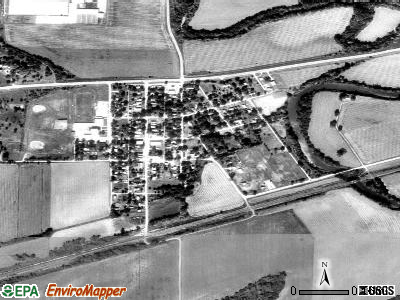
Linwood, Kansas
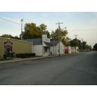
Linwood: Downtown City of Linwood, Kansas_1
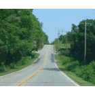
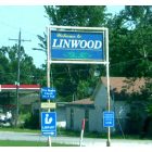
Linwood: City of Linwood, Kansas_Road into Linwood
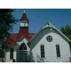
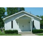
Linwood: City of Linwood, Kansas_United Methodist Church
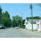
Linwood: City of Linwood, Kansas_Downtown Main Street_2
Linwood: First Baptist Church, Linwood, Kansas

Linwood: City of Linwood, Kansas_ Cemetary_1
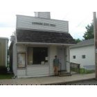
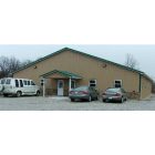
Linwood: Linwood City Hall, Kansas
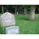
Linwood: City of Linwood, Kansas_Downtown Cemetary_2
Linwood: City of Linwood, Kansas_United Methodist Church
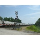
Linwood: City of Linwood, Kansas_Train going through Linwood
Linwood: City of Linwood, Kansas_
- see
15
more - add
your
Submit your own pictures of this city and show them to the world
- OSM Map
- General Map
- Google Map
- MSN Map
Population change since 2000: +14.2%
 |
| Males: 198 | |
| Females: 229 |
| Median resident age: | 30.5 years |
| Kansas median age: | 37.6 years |
Zip codes: 66052.
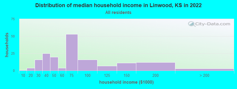
| Linwood: | $56,577 |
| KS: | $68,925 |
Estimated per capita income in 2022: $32,907 (it was $13,008 in 2000)
Linwood city income, earnings, and wages data
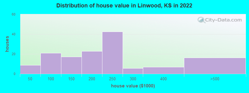
Estimated median house or condo value in 2022: $222,537 (it was $67,500 in 2000)
| Linwood: | $222,537 |
| KS: | $206,600 |
Mean prices in 2022: all housing units: $276,551; detached houses: $289,135; mobile homes: $38,379
Median gross rent in 2022: $928.
(7.2% for White Non-Hispanic residents, 6.7% for two or more races residents)
Detailed information about poverty and poor residents in Linwood, KS
Compare current foreclosures near Linwood, KS:
| Photo | Address | Area | Beds / Baths | Price | Details |
|---|---|---|---|---|---|

|
#1
206th St
Linwood, KS 66052
|
1,545 sq. feet
|
2 baths 3 beds |
show details | |

|
#2
Kreider Rd
Linwood, KS 66052
|
2,007 sq. feet
|
3 baths 3 beds |
show details | |

|
#3
174th St
Linwood, KS 66052
|
- sq. feet
|
- baths - beds |
show details | |

|
#4
Sharon Dr
Lawrence, KS 66049
|
1,648 sq. feet
|
2 baths 3 beds |
show details | |

|
#5
W 26th Ln
Eudora, KS 66025
|
1,514 sq. feet
|
2 baths 3 beds |
show details | |

|
#6
N 6th St
Baldwin City, KS 66006
|
2,548 sq. feet
|
3 baths 3 beds |
show details | |

|
#7
E 1950th Rd
Eudora, KS 66025
|
1,507 sq. feet
|
2 baths 3 beds |
show details | |

|
#8
Pamela Ln
Lawrence, KS 66049
|
1,344 sq. feet
|
2 baths 4 beds |
show details | |

|
#9
E 5th St
Edgerton, KS 66021
|
1,214 sq. feet
|
1 baths 3 beds |
show details | |

|
#10
E 120th St
Olathe, KS 66061
|
1,268 sq. feet
|
2 baths 3 beds |
show details |
| Photo | Address | Area | Beds / Baths | Price | Details |
|---|---|---|---|---|---|

|
#11
N 121st Ter
Kansas City, KS 66109
|
2,153 sq. feet
|
2 baths 3 beds |
show details | |

|
#12
Charlotte St
Shawnee, KS 66216
|
1,622 sq. feet
|
2 baths 3 beds |
show details | |

|
#13
Woodstone St
Lenexa, KS 66219
|
2,441 sq. feet
|
2 baths 4 beds |
show details | |

|
#14
Pinewood St
Gardner, KS 66030
|
1,808 sq. feet
|
2 baths 4 beds |
show details | |

|
#15
Polfer Rd
Kansas City, KS 66109
|
1,342 sq. feet
|
2 baths 3 beds |
show details | |

|
#16
E Cedar St
Olathe, KS 66061
|
816 sq. feet
|
1 baths 2 beds |
show details | |

|
#17
Buck Creek Rd
Perry, KS 66073
|
1,652 sq. feet
|
1 baths 3 beds |
show details | |

|
#18
S Oak St
Gardner, KS 66030
|
984 sq. feet
|
1 baths 3 beds |
show details | |

|
#19
N Anne Shirley Dr
Olathe, KS 66061
|
1,734 sq. feet
|
3 baths 3 beds |
show details | |

|
#20
S Stevenson St
Olathe, KS 66061
|
1,650 sq. feet
|
2 baths 4 beds |
show details |
| Photo | Address | Area | Beds / Baths | Price | Details |
|---|---|---|---|---|---|

|
#21
N 123rd Ter
Kansas City, KS 66109
|
1,820 sq. feet
|
2 baths 3 beds |
show details | |

|
#22
Congressional Way
Lawrence, KS 66049
|
1,627 sq. feet
|
3 baths 4 beds |
show details | |

|
#23
Swarner Dr
Lenexa, KS 66219
|
2,595 sq. feet
|
3 baths 4 beds |
show details | |

|
#24
E Cedar St
Olathe, KS 66061
|
1,782 sq. feet
|
2 baths 3 beds |
show details | |

|
#25
E Shawnee St
Gardner, KS 66030
|
1,700 sq. feet
|
2 baths 4 beds |
show details | |

|
#26
E Piatt Ln
Olathe, KS 66061
|
1,889 sq. feet
|
2 baths 4 beds |
show details | |

|
#27
N Church St
Olathe, KS 66061
|
1,765 sq. feet
|
2 baths 3 beds |
show details | |

|
#28
Coneflower Ct
Lawrence, KS 66047
|
2,298 sq. feet
|
2 baths 4 beds |
show details | |

|
#29
E Cothrell St
Olathe, KS 66061
|
1,377 sq. feet
|
2 baths 3 beds |
show details | |

|
#30
Oakview Ln
Shawnee, KS 66216
|
2,747 sq. feet
|
3 baths 4 beds |
show details |
| Photo | Address | Area | Beds / Baths | Price | Details |
|---|---|---|---|---|---|

|
#31
Whispering Ln
Kansas City, KS 66109
|
1,335 sq. feet
|
2 baths 3 beds |
show details | |

|
#32
E Cedar St
Olathe, KS 66061
|
792 sq. feet
|
1 baths 2 beds |
show details | |

|
#33
Elm St
Gardner, KS 66030
|
2,003 sq. feet
|
2 baths 4 beds |
show details | |

|
#34
E Dogwood St
Gardner, KS 66030
|
2,128 sq. feet
|
3 baths 4 beds |
show details | |

|
#35
Webster Ave
Kansas City, KS 66109
|
2,102 sq. feet
|
3 baths 4 beds |
show details | |

|
#36
S Sheridan Cir
Olathe, KS 66061
|
1,296 sq. feet
|
2 baths 3 beds |
show details | |

|
#37
E Willow St
Gardner, KS 66030
|
1,576 sq. feet
|
2 baths 3 beds |
show details | |

|
#38
S Sheridan Cir
Olathe, KS 66061
|
1,590 sq. feet
|
2 baths 3 beds |
show details | |

|
#39
W 185th St
Gardner, KS 66030
|
1,901 sq. feet
|
3 baths 4 beds |
show details | |

|
#40
E Sheridan St
Olathe, KS 66061
|
1,626 sq. feet
|
2 baths 4 beds |
show details |
| Photo | Address | Area | Beds / Baths | Price | Details |
|---|---|---|---|---|---|

|
#41
Barnett Ave
Kansas City, KS 66112
|
2,659 sq. feet
|
3 baths 4 beds |
show details | |

|
#42
S Sheridan Cir
Olathe, KS 66061
|
912 sq. feet
|
1 baths 3 beds |
show details | |

|
#43
Greenwood St
Lenexa, KS 66215
|
1,991 sq. feet
|
2 baths 3 beds |
show details | |

|
#44
W 89th St
Lenexa, KS 66215
|
2,828 sq. feet
|
3 baths 4 beds |
show details | |

|
#45
W 93rd St
Lenexa, KS 66215
|
1,912 sq. feet
|
3 baths 5 beds |
show details | |

|
#46
Rankin Dr
Lawrence, KS 66049
|
2,255 sq. feet
|
3 baths 5 beds |
show details | |

|
#47
Butternut St
Gardner, KS 66030
|
1,854 sq. feet
|
3 baths 3 beds |
show details | |

|
#48
Whispering Ln
Kansas City, KS 66109
|
1,622 sq. feet
|
2 baths 3 beds |
show details | |

|
#49
Stoneback Dr
Lawrence, KS 66047
|
1,142 sq. feet
|
3 baths 4 beds |
show details | |

|
Check over 1 million property listings on Foreclosure.com!
|
browse all offers | |||


- 32188.2%White alone
- 3910.7%Hispanic
- 30.8%Two or more races
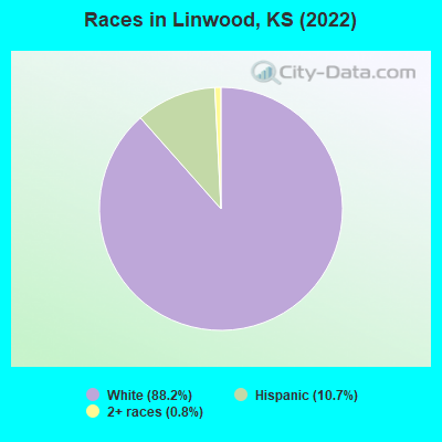
Races in Linwood detailed stats: ancestries, foreign born residents, place of birth
According to our research of Kansas and other state lists, there were 4 registered sex offenders living in Linwood, Kansas as of April 29, 2024.
The ratio of all residents to sex offenders in Linwood is 98 to 1.
 Recent articles from our blog. Our writers, many of them Ph.D. graduates or candidates, create easy-to-read articles on a wide variety of topics.


Latest news from Linwood, KS collected exclusively by city-data.com from local newspapers, TV, and radio stations
Ancestries: American (38.8%), Swedish (21.1%), English (10.2%), German (4.8%), Polish (4.1%), Irish (2.7%).
Current Local Time: CST time zone
Elevation: 800 feet
Land area: 0.41 square miles.
Population density: 1,030 people per square mile (low).
4 residents are foreign born
| This city: | 1.1% |
| Kansas: | 7.1% |
Median real estate property taxes paid for housing units with mortgages in 2022: $2,942 (1.2%)
Median real estate property taxes paid for housing units with no mortgage in 2022: $1,076 (0.7%)
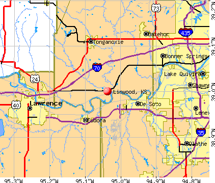
Nearest city with pop. 50,000+: Lawrence, KS  (12.0 miles , pop. 80,098).
Nearest city with pop. 200,000+: Kansas City, MO (26.4 miles , pop. 441,545).
Nearest city with pop. 1,000,000+: Chicago, IL (434.2 miles , pop. 2,896,016).
Nearest cities:
)Latitude: 39.00 N, Longitude: 95.04 W
Area code: 913
Single-family new house construction building permits:
- 2021: 2 buildings, average cost: $80,700
- 2020: 4 buildings, average cost: $128,400
- 2019: 6 buildings, average cost: $157,900
- 2018: 12 buildings, average cost: $142,000
- 2016: 1 building, cost: $150,700
- 2008: 4 buildings, average cost: $60,000
- 2006: 1 building, cost: $126,000
- 2005: 5 buildings, average cost: $93,000
- 2004: 2 buildings, average cost: $95,000
- 2003: 1 building, cost: $100,000
- 2002: 4 buildings, average cost: $122,500
- 2001: 1 building, cost: $80,000
- 2000: 1 building, cost: $40,000
| Here: | 2.1% |
| Kansas: | 2.0% |
- Construction (7.8%)
- Health care (7.8%)
- Machinery (6.1%)
- Truck transportation (5.0%)
- Administrative & support & waste management services (5.0%)
- Professional, scientific, technical services (4.4%)
- Repair & maintenance (4.4%)
- Construction (15.1%)
- Administrative & support & waste management services (8.6%)
- Machinery (7.5%)
- Repair & maintenance (6.5%)
- Motor vehicle & parts dealers (5.4%)
- Truck transportation (5.4%)
- Professional & commercial equipment & supplies merchant wholesalers (3.2%)
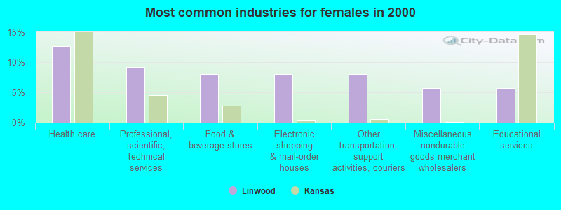
- Health care (12.6%)
- Professional, scientific, technical services (9.2%)
- Food & beverage stores (8.0%)
- Electronic shopping & mail-order houses (8.0%)
- Other transportation, support activities, couriers (8.0%)
- Miscellaneous nondurable goods merchant wholesalers (5.7%)
- Educational services (5.7%)
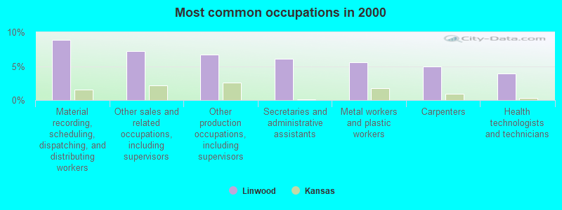
- Material recording, scheduling, dispatching, and distributing workers (8.9%)
- Other sales and related occupations, including supervisors (7.2%)
- Other production occupations, including supervisors (6.7%)
- Secretaries and administrative assistants (6.1%)
- Metal workers and plastic workers (5.6%)
- Carpenters (5.0%)
- Health technologists and technicians (3.9%)
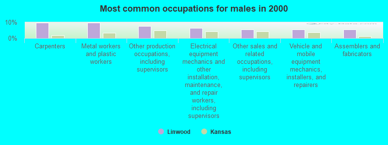
- Carpenters (9.7%)
- Metal workers and plastic workers (9.7%)
- Other production occupations, including supervisors (7.5%)
- Electrical equipment mechanics and other installation, maintenance, and repair workers, including supervisors (6.5%)
- Other sales and related occupations, including supervisors (5.4%)
- Vehicle and mobile equipment mechanics, installers, and repairers (5.4%)
- Assemblers and fabricators (5.4%)
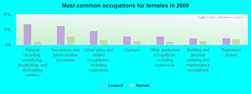
- Material recording, scheduling, dispatching, and distributing workers (13.8%)
- Secretaries and administrative assistants (12.6%)
- Other sales and related occupations, including supervisors (9.2%)
- Cashiers (5.7%)
- Other production occupations, including supervisors (5.7%)
- Building and grounds cleaning and maintenance occupations (4.6%)
- Registered nurses (4.6%)
Average climate in Linwood, Kansas
Based on data reported by over 4,000 weather stations


(lower is better)
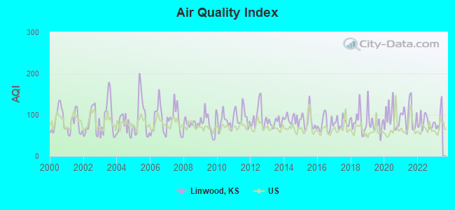
Air Quality Index (AQI) level in 2022 was 81.3. This is about average.
| City: | 81.3 |
| U.S.: | 72.6 |
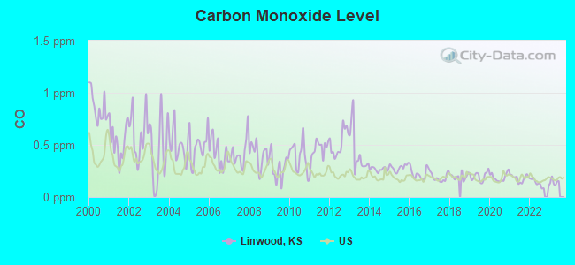
Carbon Monoxide (CO) [ppm] level in 2022 was 0.132. This is significantly better than average. Closest monitor was 11.3 miles away from the city center.
| City: | 0.132 |
| U.S.: | 0.251 |
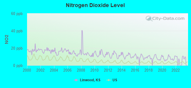
Nitrogen Dioxide (NO2) [ppb] level in 2021 was 8.27. This is significantly worse than average. Closest monitor was 10.9 miles away from the city center.
| City: | 8.27 |
| U.S.: | 5.11 |
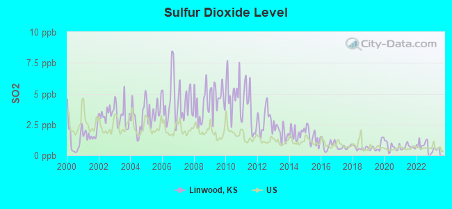
Sulfur Dioxide (SO2) [ppb] level in 2022 was 0.856. This is significantly better than average. Closest monitor was 10.9 miles away from the city center.
| City: | 0.856 |
| U.S.: | 1.515 |
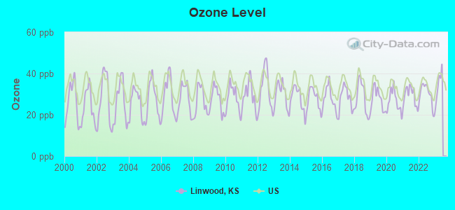
Ozone [ppb] level in 2022 was 30.0. This is about average. Closest monitor was 9.0 miles away from the city center.
| City: | 30.0 |
| U.S.: | 33.3 |
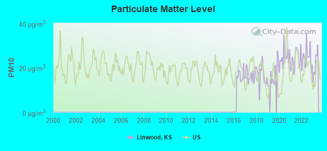
Particulate Matter (PM10) [µg/m3] level in 2022 was 24.3. This is worse than average. Closest monitor was 18.6 miles away from the city center.
| City: | 24.3 |
| U.S.: | 19.2 |
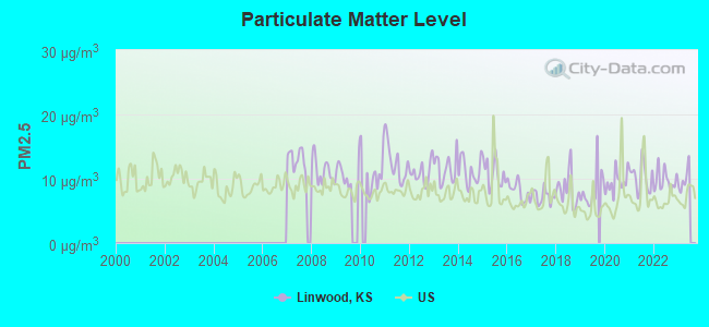
Particulate Matter (PM2.5) [µg/m3] level in 2022 was 9.72. This is about average. Closest monitor was 17.3 miles away from the city center.
| City: | 9.72 |
| U.S.: | 8.11 |
Tornado activity:
Linwood-area historical tornado activity is slightly above Kansas state average. It is 109% greater than the overall U.S. average.
On 5/22/1952, a category F4 (max. wind speeds 207-260 mph) tornado 9.9 miles away from the Linwood city center injured 3 people and caused between $50,000 and $500,000 in damages.
On 6/8/1966, a category F5 (max. wind speeds 261-318 mph) tornado 29.7 miles away from the city center killed 16 people and injured 450 people and caused between $50,000,000 and $500,000,000 in damages.
Earthquake activity:
Linwood-area historical earthquake activity is significantly above Kansas state average. It is 533% greater than the overall U.S. average.On 9/3/2016 at 12:02:44, a magnitude 5.8 (5.8 MW, Depth: 3.5 mi, Class: Moderate, Intensity: VI - VII) earthquake occurred 206.0 miles away from the city center
On 11/6/2011 at 03:53:10, a magnitude 5.7 (5.7 MW, Depth: 3.2 mi) earthquake occurred 258.1 miles away from Linwood center
On 11/12/2014 at 21:40:00, a magnitude 4.9 (4.9 MW, Depth: 2.5 mi, Class: Light, Intensity: IV - V) earthquake occurred 184.5 miles away from the city center
On 11/7/2016 at 01:44:24, a magnitude 5.0 (5.0 MW, Depth: 2.8 mi) earthquake occurred 229.6 miles away from the city center
On 2/13/2016 at 17:07:06, a magnitude 5.1 (5.1 MW, Depth: 5.2 mi) earthquake occurred 265.5 miles away from Linwood center
On 1/19/2020 at 19:08:42, a magnitude 4.5 (4.5 MW, Depth: 3.1 mi) earthquake occurred 172.6 miles away from Linwood center
Magnitude types: moment magnitude (MW)
Natural disasters:
The number of natural disasters in Leavenworth County (20) is greater than the US average (15).Major Disasters (Presidential) Declared: 15
Emergencies Declared: 3
Causes of natural disasters: Floods: 14, Storms: 11, Tornadoes: 6, Winter Storms: 4, Heavy Rain: 1, Hurricane: 1, Ice Storm: 1, Landslide: 1, Mudslide: 1, Snowstorm: 1, Wind: 1, Other: 1 (Note: some incidents may be assigned to more than one category).

Hospitals and medical centers near Linwood:
- CEDAR GROVE HEALTH CARE (Nursing Home, about 4 miles away; DE SOTO, KS)
- HILLSIDE VILLAGE OF DESOTO (Nursing Home, about 4 miles away; DE SOTO, KS)
- MEDICALODGES EUDORA (Nursing Home, about 6 miles away; EUDORA, KS)
- TONGANOXIE NURSING CENTER (Nursing Home, about 8 miles away; TONGANOXIE, KS)
- KANSAS INSTITUTE (Hospital, about 10 miles away; OLATHE, KS)
- HILLSIDE HEALTH CARE CENTER (Nursing Home, about 10 miles away; BONNER SPRINGS, KS)
- BONNER SPRINGS NURSING AND REHABILITATION CENTER (Nursing Home, about 10 miles away; BONNER SPRINGS, KS)
Colleges/universities with over 2000 students nearest to Linwood:
- University of Kansas (about 12 miles; Lawrence, KS; Full-time enrollment: 22,788)
- MidAmerica Nazarene University (about 17 miles; Olathe, KS; FT enrollment: 2,158)
- Johnson County Community College (about 18 miles; Overland Park, KS; FT enrollment: 11,976)
- Baker University (about 18 miles; Baldwin City, KS; FT enrollment: 2,752)
- Kansas City Kansas Community College (about 18 miles; Kansas City, KS; FT enrollment: 4,718)
- Wright Career College (about 21 miles; Overland Park, KS; FT enrollment: 3,107)
- Park University (about 24 miles; Parkville, MO; FT enrollment: 9,131)
Points of interest:
Notable locations in Linwood: Linwood City Hall (A), Linwood Community Library (B), Sherman Township Fire Department Storage Barn (C), Sherman Township Fire Department Linwood (D). Display/hide their locations on the map
Churches in Linwood include: Linwood Church of Christ (A), First Baptist Church of Linwood (B), Linwood United Methodist Church (C). Display/hide their locations on the map
Cemetery: Congregational Cemetery (1). Display/hide its location on the map
Drinking water stations with addresses in Linwood and their reported violations in the past:
LEAVENWORTH CO RWD 10 (Population served: 499, Purch surface water):Past monitoring violations:
- 5 routine major monitoring violations
Drinking water stations with addresses in Linwood that have no violations reported:
- LINWOOD, CITY OF (Population served: 381, Primary Water Source Type: Purch surface water)
| This city: | 2.7 people |
| Kansas: | 2.5 people |
| This city: | 66.2% |
| Whole state: | 66.0% |
| This city: | 15.8% |
| Whole state: | 5.8% |
No gay or lesbian households reported
For population 15 years and over in Linwood:
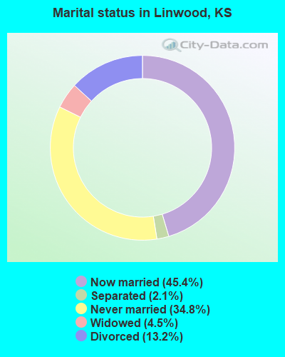
- Never married: 34.8%
- Now married: 45.4%
- Separated: 2.1%
- Widowed: 4.5%
- Divorced: 13.2%
For population 25 years and over in Linwood:
- High school or higher: 84.2%
- Bachelor's degree or higher: 22.5%
- Graduate or professional degree: 1.4%
- Unemployed: 1.1%
- Mean travel time to work (commute): 35.8 minutes
| Here: | 7.5 |
| Kansas average: | 11.5 |
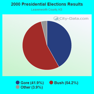
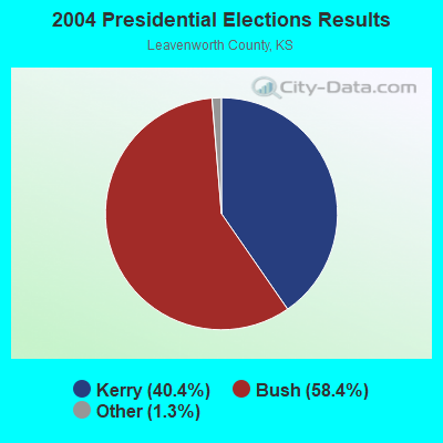
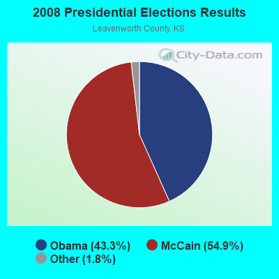
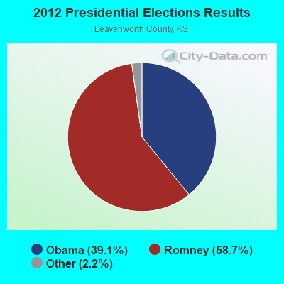
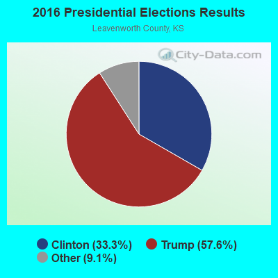
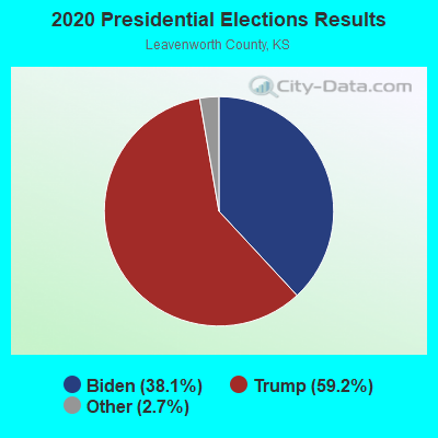
Graphs represent county-level data. Detailed 2008 Election Results
Religion statistics for Linwood, KS (based on Leavenworth County data)
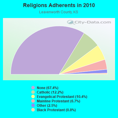
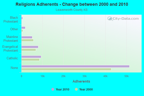
| Religion | Adherents | Congregations |
|---|---|---|
| Catholic | 9,321 | 7 |
| Evangelical Protestant | 7,953 | 44 |
| Mainline Protestant | 5,094 | 19 |
| Other | 1,869 | 8 |
| Black Protestant | 579 | 4 |
| None | 51,411 | - |
Food Environment Statistics:
| This county: | 0.82 / 10,000 pop. |
| Kansas: | 1.96 / 10,000 pop. |
| This county: | 0.14 / 10,000 pop. |
| Kansas: | 0.51 / 10,000 pop. |
| Leavenworth County: | 3.26 / 10,000 pop. |
| State: | 3.84 / 10,000 pop. |
| Here: | 4.35 / 10,000 pop. |
| Kansas: | 7.33 / 10,000 pop. |
| Leavenworth County: | 7.8% |
| State: | 8.1% |
| This county: | 27.8% |
| Kansas: | 27.9% |
| This county: | 13.9% |
| Kansas: | 13.4% |
Health and Nutrition:
| Linwood: | 52.4% |
| State: | 49.2% |
| Linwood: | 52.4% |
| State: | 46.3% |
| This city: | 27.1 |
| Kansas: | 28.6 |
| This city: | 19.4% |
| Kansas: | 21.2% |
| Linwood: | 7.6% |
| State: | 10.5% |
| Linwood: | 7.0 |
| Kansas: | 6.8 |
| Linwood: | 27.9% |
| Kansas: | 33.5% |
| Linwood: | 61.4% |
| Kansas: | 56.0% |
| Linwood: | 82.2% |
| State: | 78.6% |
More about Health and Nutrition of Linwood, KS Residents
| Local government employment and payroll (March 2022) | |||||
| Function | Full-time employees | Monthly full-time payroll | Average yearly full-time wage | Part-time employees | Monthly part-time payroll |
|---|---|---|---|---|---|
| Financial Administration | 5 | $11,341 | $27,218 | 0 | $0 |
| Other Government Administration | 0 | $0 | 6 | $30 | |
| Totals for Government | 5 | $11,341 | $27,218 | 6 | $30 |
Linwood government finances - Expenditure in 2017 (per resident):
- Current Operations - Central Staff Services: $54,000 ($126.46)
Sewerage: $52,000 ($121.78)
Water Utilities: $46,000 ($107.73)
Solid Waste Management: $19,000 ($44.50)
Financial Administration: $3,000 ($7.03)
- General - Interest on Debt: $14,000 ($32.79)
- Other Capital Outlay - Sewerage: $60,000 ($140.52)
Regular Highways: $50,000 ($117.10)
Financial Administration: $47,000 ($110.07)
Water Utilities: $20,000 ($46.84)
Toll Highways: $5,000 ($11.71)
Parks and Recreation: $1,000 ($2.34)
Linwood government finances - Revenue in 2017 (per resident):
- Charges - Sewerage: $52,000 ($121.78)
Solid Waste Management: $1,000 ($2.34)
- Revenue - Water Utilities: $46,000 ($107.73)
- State Intergovernmental - Highways: $4,000 ($9.37)
General Local Government Support: $2,000 ($4.68)
- Tax - Property: $55,000 ($128.81)
Other Selective Sales: $12,000 ($28.10)
General Sales and Gross Receipts: $10,000 ($23.42)
Linwood government finances - Debt in 2017 (per resident):
- Long Term Debt - Beginning Outstanding - Unspecified Public Purpose: $345,000 ($807.96)
Outstanding Unspecified Public Purpose: $291,000 ($681.50)
Retired Unspecified Public Purpose: $54,000 ($126.46)
10.92% of this county's 2021 resident taxpayers lived in other counties in 2020 ($74,110 average adjusted gross income)
| Here: | 10.92% |
| Kansas average: | 6.64% |
0.31% of residents moved from foreign countries ($2,028 average AGI)
Leavenworth County: 0.31% Kansas average: 0.04%
Top counties from which taxpayers relocated into this county between 2020 and 2021:
| from Wyandotte County, KS | |
| from Johnson County, KS | |
| from Douglas County, KS |
10.24% of this county's 2020 resident taxpayers moved to other counties in 2021 ($64,678 average adjusted gross income)
| Here: | 10.24% |
| Kansas average: | 6.88% |
0.23% of residents moved to foreign countries ($2,050 average AGI)
Leavenworth County: 0.23% Kansas average: 0.03%
Top counties to which taxpayers relocated from this county between 2020 and 2021:
| to Johnson County, KS | |
| to Wyandotte County, KS | |
| to Jackson County, MO |
Strongest AM radio stations in Linwood:
- WHB (810 AM; 50 kW; KANSAS CITY, MO; Owner: UNION BROADCASTING, INC.)
- KKHK (1250 AM; 25 kW; KANSAS CITY, KS)
- KCSP (610 AM; 5 kW; KANSAS CITY, MO; Owner: ENTERCOM KANSAS CITY LICENSE, LLC)
- KXTR (1660 AM; 10 kW; KANSAS CITY, KS; Owner: ENTERCOM KANSAS CITY LICENSE, LLC)
- KCMO (710 AM; 10 kW; KANSAS CITY, MO; Owner: SUSQUEHANNA KANSAS CITY PARTNERSHIP)
- KMBZ (980 AM; 5 kW; KANSAS CITY, MO; Owner: ENTERCOM KANSAS CITY LICENSE, LLC)
- KCCV (760 AM; daytime; 6 kW; OVERLAND PARK, KS; Owner: BOTT BROADCASTING COMPANY)
- KKLO (1410 AM; 5 kW; LEAVENWORTH, KS; Owner: CHARA COMMUNICATIONS, INC.)
- KCTE (1510 AM; daytime; 10 kW; INDEPENDENCE, MO; Owner: UNION BROADCASTING, INC.)
- KPHN (1190 AM; 5 kW; KANSAS CITY, MO; Owner: ABC, INC.)
- WIBW (580 AM; 5 kW; TOPEKA, KS; Owner: MCC RADIO, LLC)
- KCNW (1380 AM; 2 kW; FAIRWAY, KS; Owner: KANSAS CITY RADIO, INC.)
- KMAJ (1440 AM; 5 kW; TOPEKA, KS; Owner: CUMULUS LICENSING CORP.)
Strongest FM radio stations in Linwood:
- KANU (91.5 FM; LAWRENCE, KS; Owner: UNIVERSITY OF KANSAS)
- KCCV-FM (92.3 FM; OLATHE, KS; Owner: BOTT BROADCASTING COMPANY)
- KFKF-FM (94.1 FM; KANSAS CITY, KS; Owner: INFINITY RADIO SUBSIDIARY OPERATIONS INC.)
- KZPL (97.3 FM; LEE'S SUMMIT, MO; Owner: UNION FIRST BROADCASTING, LLC)
- KCMO-FM (94.9 FM; KANSAS CITY, MO; Owner: SUSQUEHANNA KANSAS CITY PARTNERSHIP)
- KQRC-FM (98.9 FM; LEAVENWORTH, KS; Owner: ENTERCOM KANSAS CITY LICENSE, LLC)
- KRBZ (96.5 FM; KANSAS CITY, MO; Owner: ENTERCOM KANSAS CITY LICENSE, LLC)
- KYYS (99.7 FM; KANSAS CITY, MO; Owner: ENTERCOM KANSAS CITY LICENSE, LLC)
- KLZR (105.9 FM; LAWRENCE, KS; Owner: ZIMMER RADIO OF MID-MISSOURI, INC)
- KMXV (93.3 FM; KANSAS CITY, MO; Owner: INFINITY RADIO OPERATIONS INC.)
- KCHZ (95.7 FM; OTTAWA, KS; Owner: SYNCOM RADIO CORPORATION)
- WDAF-FM (106.5 FM; LIBERTY, MO; Owner: ENTERCOM KANSAS CITY LICENSE, LLC)
- KUDL (98.1 FM; KANSAS CITY, KS; Owner: ENTERCOM KANSAS CITY LICENSE, LLC)
- KSRC (102.1 FM; KANSAS CITY, MO; Owner: INFINITY RADIO OPERATIONS INC.)
- KPRS (103.3 FM; KANSAS CITY, MO; Owner: CARTER BROADCAST GROUP, INC.)
- KJHK (90.7 FM; LAWRENCE, KS; Owner: THE UNIVERSITY OF KANSAS)
- KBEQ-FM (104.3 FM; KANSAS CITY, MO; Owner: INFINITY RADIO SUBSIDIARY OPERATIONS INC.)
- KCFX (101.1 FM; HARRISONVILLE, MO; Owner: SUSQUEHANNA KANSAS CITY PARTNERSHIP)
- KCUR-FM (89.3 FM; KANSAS CITY, MO; Owner: CURATORS OF UNIVERSITY OF MISSOURI)
- KLJC (88.5 FM; KANSAS CITY, MO; Owner: CALVARY BIBLE COLLEGE)
TV broadcast stations around Linwood:
- KCTV (Channel 5; KANSAS CITY, MO; Owner: MEREDITH CORPORATION)
- KMBC-TV (Channel 9; KANSAS CITY, MO; Owner: KMBC HEARST-ARGYLE TELEVISION, INC.)
- KSHB-TV (Channel 41; KANSAS CITY, MO; Owner: SCRIPPS HOWARD BROADCASTING COMPANY)
- KMCI (Channel 38; LAWRENCE, KS; Owner: SCRIPPS HOWARD BROADCASTING COMPANY)
- WDAF-TV (Channel 4; KANSAS CITY, MO; Owner: WDAF LICENSE, INC.)
- KPXE (Channel 50; KANSAS CITY, MO; Owner: PAXSON KANSAS CITY LICENSE, INC.)
- KUJH-LP (Channel 14; LAWRENCE, KS; Owner: UNIVERSITY OF KANSAS)
- KCPT (Channel 19; KANSAS CITY, MO; Owner: PUBLIC TELEVISION 19, INC.)
- KCWE (Channel 29; KANSAS CITY, MO; Owner: KCWE-TV, INC.)
- KSMO-TV (Channel 62; KANSAS CITY, MO; Owner: KSMO LICENSEE, INC.)
- K35CT (Channel 35; KANSAS CITY, MO; Owner: WORD OF GOD FELLOWSHIP, INC.)
- K48FS (Channel 48; KANSAS CITY, MO; Owner: WORD OF GOD FELLOWSHIP, INC.)
- KTWU (Channel 11; TOPEKA, KS; Owner: WASHBURN UNIVERSITY OF TOPEKA)
- KTKA-TV (Channel 49; TOPEKA, KS; Owner: NORTHEAST KANSAS BROADCAST SERVICE, INC.)
- KSNT (Channel 27; TOPEKA, KS; Owner: EMMIS TELEVISION LICENSE CORPORATION OF TOPEKA)
- K58CX (Channel 58; LAWRENCE, KS; Owner: NORTHEAST KANSAS BROADCAST SERVICE, INC.)
- K26CR (Channel 26; KANSAS CITY, MO; Owner: VENTANA TELEVISION, INC.)
Linwood fatal accident list:
Apr 17, 1997 00:30 AM, 32, Vehicles: 1, Persons: 1, Fatalities: 1, Drunk persons involved: 1
Jan 30, 1994 00:45 AM, M05202, Vehicles: 1, Persons: 1, Fatalities: 1, Drunk persons involved: 1
- National Bridge Inventory (NBI) Statistics
- 13Number of bridges
- 249ft / 75.7mTotal length
- $1,485,000Total costs
- 35,116Total average daily traffic
- 6,527Total average daily truck traffic
- 56,298Total future (year 2038) average daily traffic
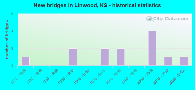
- New bridges - historical statistics
- 11920-1929
- 21950-1959
- 21970-1979
- 21980-1989
- 42000-2009
- 12010-2019
- 12020-2022
FCC Registered Antenna Towers:
13 (See the full list of FCC Registered Antenna Towers in Linwood)FCC Registered Broadcast Land Mobile Towers:
3- Uprr Loring 4 Mi Ne (Lat: 39.035833 Lon: -94.982472), Type: Tower, Structure height: 49 m, Overall height: 53 m, Call Sign: WNLM330,
Assigned Frequencies: 935.887 MHz, 935.937 MHz, 935.987 MHz, 936.887 MHz, 936.937 MHz, 936.987 MHz, Grant Date: 02/11/1998, Expiration Date: 02/11/2003, Cancellation Date: 04/13/2001, Certifier: Robert Vandeberg, Registrant: B & R Consultants Inc, 13360 S Cliffside Dr, Mulino, OR 97042-9636, Fax: (503) 632-3142
- mobile, Call Sign: WQAP266,
Assigned Frequencies: 457.762 MHz, Grant Date: 06/21/2014, Expiration Date: 07/13/2024, Certifier: Larry Kopiasz, Registrant: Prokarma, 222 So 15th St., Suite 505n, Omaha, NE 68102, Phone: (402) 522-5068, Fax: (402) 343-6676, Email:
- Lat: 39.001222 Lon: -95.039194, Call Sign: WQNG674,
Assigned Frequencies: 460.537 MHz, 465.537 MHz, Grant Date: 12/09/2020, Expiration Date: 02/01/2031, Certifier: Charles D Call, Registrant: Business Radio Licensing, 30251 Golden Lantern, Suite E # 501, Laguna Niguel, CA 92677, Phone: (949) 348-8510, Fax: (949) 348-8514, Email:
FCC Registered Microwave Towers:
7- STATION, Loring 40 Mi Ne Of (Lat: 39.035833 Lon: -94.982444), Overall height: 53.3 m, Call Sign: WNTL784,
Assigned Frequencies: 952.018 MHz, 928.018 MHz, Grant Date: 11/19/2021, Expiration Date: 12/31/2031, Cancellation Date: 06/29/2022, Registrant: Prokarma, 222 S 15th St Suite 505n, Omaha, NE 68102, Phone: (402) 522-5068, Fax: (402) 346-6676, Email:
- KS00135, Lat: 39.044500 Lon: -94.991944, Type: Tank, Structure height: 39.6 m, Call Sign: WQMJ533,
Assigned Frequencies: 3650.00 MHz, Grant Date: 08/24/2010, Expiration Date: 10/17/2020, Cancellation Date: 12/19/2020, Certifier: Matt Sams, Registrant: Mercury Access Solutions, 6714 Pointe Inverness Way, Ste 230, Fort Wayne, IN 46804, Phone: (800) 354-4915, Fax: (785) 748-4624, Email:
- Linwood, 1.5 Km Ne (Lat: 39.012500 Lon: -95.029722), Type: Gtower, Structure height: 318.5 m, Overall height: 319.7 m, Call Sign: WRMB344,
Assigned Frequencies: 10915.0 MHz, 11245.0 MHz, 10915.0 MHz, 11245.0 MHz, 10915.0 MHz, 11245.0 MHz, 10915.0 MHz, 11245.0 MHz, 11245.0 MHz, 11245.0 MHz... (+8 more), Grant Date: 03/16/2021, Expiration Date: 03/16/2031, Certifier: Stan J Gray, Registrant: Micronet Communications, Inc., 812 Lexington Dr, Plano, TX 75075, Phone: (972) 422-7200, Email:
- LIBM, 1.5 Km Ne (Lat: 39.012500 Lon: -95.029722), Type: Gtower, Structure height: 318.5 m, Overall height: 319.7 m, Call Sign: WRME257, Licensee ID: L01973315,
Assigned Frequencies: 17900.0 MHz, 17900.0 MHz, 17900.0 MHz, 17900.0 MHz, 17900.0 MHz, 17900.0 MHz, 17900.0 MHz, 17900.0 MHz, 17900.0 MHz, 17900.0 MHz... (+37 more), Grant Date: 03/26/2021, Expiration Date: 03/26/2031, Certifier: Garrett Wiseman, Registrant: Mercury Wireless Kansas, LLC, 3301 S Kansas Ave, Topeka, KS 66611, Phone: (800) 354-4915, Email:
- LORING, Loring 4.0 Mi Ne Of (Lat: 39.035833 Lon: -94.982444), Type: Tower, Structure height: 53.3 m, Call Sign: KTM85,
Assigned Frequencies: 6745.00 MHz, 6865.00 MHz, Grant Date: 04/23/2021, Expiration Date: 12/20/2030, Registrant: Prokarma, 222 S 15th St Suite 505n, Omaha, NE 68102, Phone: (402) 522-5068, Fax: (402) 346-6676, Email:
FCC Registered Amateur Radio Licenses:
22 (See the full list of FCC Registered Amateur Radio Licenses in Linwood)| Home Mortgage Disclosure Act Aggregated Statistics For Year 2009 (Based on 1 partial tract) | ||
| C) Refinancings | ||
|---|---|---|
| Number | Average Value | |
| LOANS ORIGINATED | 1 | $140,490 |
| APPLICATIONS APPROVED, NOT ACCEPTED | 0 | $0 |
| APPLICATIONS DENIED | 0 | $0 |
| APPLICATIONS WITHDRAWN | 0 | $0 |
| FILES CLOSED FOR INCOMPLETENESS | 0 | $0 |
Detailed HMDA statistics for the following Tracts: 0714.00
2002 - 2018 National Fire Incident Reporting System (NFIRS) incidents
- Fire incident types reported to NFIRS in Linwood, KS
- 40763.0%Outside Fires
- 13220.4%Structure Fires
- 589.0%Mobile Property/Vehicle Fires
- 497.6%Other
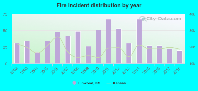 According to the data from the years 2002 - 2018 the average number of fire incidents per year is 38. The highest number of reported fires - 67 took place in 2011, and the least - 17 in 2004. The data has a decreasing trend.
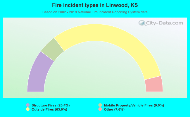 When looking into fire subcategories, the most incidents belonged to: Outside Fires (63.0%), and Structure Fires (20.4%).
| Most common first names in Linwood, KS among deceased individuals | ||
| Name | Count | Lived (average) |
|---|---|---|
| William | 12 | 74.0 years |
| Robert | 12 | 70.6 years |
| Mary | 10 | 76.7 years |
| John | 9 | 85.4 years |
| George | 8 | 76.6 years |
| Charles | 7 | 76.4 years |
| James | 7 | 76.3 years |
| Anna | 6 | 77.7 years |
| Clarence | 5 | 81.2 years |
| Helen | 4 | 74.8 years |
| Most common last names in Linwood, KS among deceased individuals | ||
| Last name | Count | Lived (average) |
|---|---|---|
| Jones | 7 | 77.3 years |
| Wilson | 5 | 75.0 years |
| Jenkins | 4 | 82.0 years |
| Bailey | 4 | 76.0 years |
| Holmes | 4 | 87.2 years |
| Browning | 4 | 85.2 years |
| Torneden | 4 | 80.3 years |
| Bryant | 3 | 79.0 years |
| Hamill | 3 | 76.4 years |
| Huffman | 3 | 72.0 years |
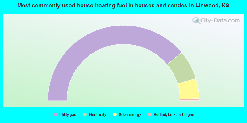
- 78.0%Utility gas
- 12.6%Electricity
- 8.7%Solar energy
- 0.8%Bottled, tank, or LP gas
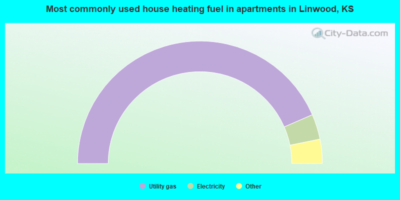
- 92.9%Utility gas
- 7.1%Electricity
Linwood compared to Kansas state average:
- Unemployed percentage significantly below state average.
- Black race population percentage significantly below state average.
- Foreign-born population percentage significantly below state average.
- Number of college students significantly below state average.

|
Total of 2 patent applications in 2008-2024.