Ramapo, New York
Submit your own pictures of this town and show them to the world
- OSM Map
- General Map
- Google Map
- MSN Map
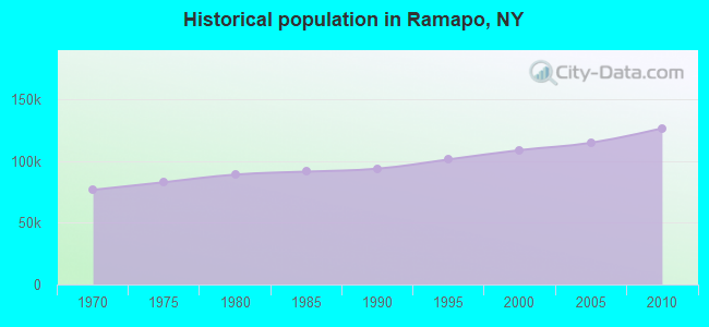
Population change since 2000: +16.2%
 |
| Males: 63,291 | |
| Females: 63,304 |
| Median resident age: | 28.9 years |
| New York median age: | 40.7 years |
Zip codes: 10952.
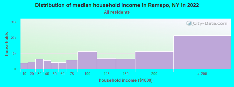
| Ramapo: | $89,143 |
| NY: | $79,557 |
Estimated per capita income in 2022: $36,098 (it was $22,868 in 2000)
Ramapo town income, earnings, and wages data
Estimated median house or condo value in 2022: $520,194 (it was $220,600 in 2000)
| Ramapo: | $520,194 |
| NY: | $400,400 |
Mean prices in 2022: all housing units: $622,388; detached houses: $694,132; townhouses or other attached units: $449,914; in 2-unit structures: $608,490; in 3-to-4-unit structures: $239,911; in 5-or-more-unit structures: $366,943; mobile homes: $68,506
Detailed information about poverty and poor residents in Ramapo, NY
Compare current foreclosures near Ramapo, NY:
| Photo | Address | Area | Beds / Baths | Price | Details |
|---|---|---|---|---|---|

|
#1
Forest Ave
Paramus, NJ 07652
|
2,428 sq. feet
|
3 baths 5 beds |
$749,900
|
show details |

|
#2
Lenni Lenape Ct
Stony Point, NY 10980
|
3,252 sq. feet
|
3 baths 4 beds |
$699,900
|
show details |

|
#3
N Broadway
Irvington, NY 10533
|
850 sq. feet
|
1 baths 2 beds |
$315,000
|
show details |

|
#4
Central Park Ave Apt 9m
Yonkers, NY 10710
|
1,300 sq. feet
|
2 baths 3 beds |
$319,900
|
show details |

|
#5
N Broadway Apt A6
Yonkers, NY 10701
|
950 sq. feet
|
2 baths 2 beds |
$219,900
|
show details |

|
#6
Oakdale Mnr Apt A6d
Suffern, NY 10901
|
750 sq. feet
|
1 baths 1 beds |
$99,900
|
show details |

|
#7
Secora Rd Apt G14
Monsey, NY 10952
|
800 sq. feet
|
1 baths 1 beds |
$139,500
|
show details |

|
#8
N Riverside Ave
Croton On Hudson, NY 10520
|
1,642 sq. feet
|
2 baths 3 beds |
$595,000
|
show details |

|
#9
Beverly Rd
Oradell, NJ 07649
|
1,200 sq. feet
|
1 baths 3 beds |
$569,900
|
show details |

|
#10
N Main St Apt C-15
Spring Valley, NY 10977
|
800 sq. feet
|
1 baths 1 beds |
$85,000
|
show details |
| Photo | Address | Area | Beds / Baths | Price | Details |
|---|---|---|---|---|---|

|
#11
Martin Dr
Harrington Park, NJ 07640
|
1,746 sq. feet
|
3 baths 3 beds |
$965,000
|
show details |

|
#12
Lookout Rd
Tuxedo Park, NY 10987
|
1,945 sq. feet
|
2 baths 1 beds |
$479,900
|
show details |

|
#13
Fifth Street
Hillburn, NY 10931
|
- sq. feet
|
1 baths 3 beds |
$462,800
|
show details |

|
#14
Glenwood Ave Apt 74
Yonkers, NY 10703
|
- sq. feet
|
1 baths 3 beds |
$313,000
|
show details |

|
#15
6th St
Hillburn, NY 10931
|
2,469 sq. feet
|
3 baths 5 beds |
show details | |

|
#16
Lexington Hl # 7
Harriman, NY 10926
|
950 sq. feet
|
2 baths 2 beds |
show details | |

|
#17
Central Park Ave
Yonkers, NY 10710
|
1,000 sq. feet
|
1 baths 2 beds |
show details | |

|
#18
Pickerel Rd
Monroe, NY 10950
|
2,092 sq. feet
|
1 baths 2 beds |
show details | |

|
#19
William St
Ossining, NY 10562
|
1,160 sq. feet
|
2 baths 3 beds |
show details | |

|
#20
Voorhis Ave
New Milford, NJ 07646
|
2,200 sq. feet
|
2 baths 3 beds |
show details |
| Photo | Address | Area | Beds / Baths | Price | Details |
|---|---|---|---|---|---|

|
#21
Sard St
Sloatsburg, NY 10974
|
1,584 sq. feet
|
1 baths 3 beds |
show details | |

|
#22
Seabird Ave
Spring Valley, NY 10977
|
2,211 sq. feet
|
4 baths 5 beds |
show details | |

|
#23
Lenape Ln
Oakland, NJ 07436
|
1,224 sq. feet
|
1 baths 2 beds |
show details | |

|
#24
James St
Stony Point, NY 10980
|
1,134 sq. feet
|
1 baths 2 beds |
show details | |

|
#25
Captain Shankey Dr
Garnerville, NY 10923
|
981 sq. feet
|
1 baths 2 beds |
show details | |

|
#26
Paul Ct
Pearl River, NY 10965
|
1,490 sq. feet
|
2 baths 3 beds |
show details | |

|
#27
Orchard St
Bloomingdale, NJ 07403
|
1,536 sq. feet
|
1 baths 4 beds |
show details | |

|
#28
Berdan St
Rochelle Park, NJ 07662
|
1,900 sq. feet
|
2 baths 3 beds |
show details | |

|
#29
Ellis Pl
Ossining, NY 10562
|
1,432 sq. feet
|
2 baths 3 beds |
show details | |

|
#30
Lafayette Ave
Westwood, NJ 07675
|
616 sq. feet
|
1 baths 3 beds |
show details |
| Photo | Address | Area | Beds / Baths | Price | Details |
|---|---|---|---|---|---|

|
#31
Hillside Ave
Yonkers, NY 10703
|
2,436 sq. feet
|
3 baths 6 beds |
show details | |

|
#32
Juniper St
Dumont, NJ 07628
|
1,550 sq. feet
|
2 baths 3 beds |
show details | |

|
#33
Kitchawan Rd
Ossining, NY 10562
|
7,000 sq. feet
|
5 baths 8 beds |
show details | |

|
#34
E 22nd St
Paterson, NJ 07513
|
1,698 sq. feet
|
2 baths 6 beds |
show details | |

|
#35
Liberty Rd
Englewood, NJ 07631
|
1,200 sq. feet
|
1 baths 3 beds |
show details | |

|
#36
Harrington Ct
Harrington Park, NJ 07640
|
3,340 sq. feet
|
2 baths 3 beds |
show details | |

|
#37
Union Ave
Garfield, NJ 07026
|
1,148 sq. feet
|
2 baths 4 beds |
show details | |

|
#38
Wilson Ct
Westwood, NJ 07675
|
1,552 sq. feet
|
2 baths 3 beds |
show details | |

|
#39
Oakwood Dr
Woodcliff Lake, NJ 07677
|
2,605 sq. feet
|
2 baths 3 beds |
show details | |

|
#40
Haverstraw Rd
Suffern, NY 10901
|
1,218 sq. feet
|
1 baths 3 beds |
show details |
| Photo | Address | Area | Beds / Baths | Price | Details |
|---|---|---|---|---|---|

|
#41
Oakland Ave
Central Valley, NY 10917
|
1,904 sq. feet
|
2 baths 4 beds |
show details | |

|
#42
Gerow Ave
Spring Valley, NY 10977
|
1,220 sq. feet
|
2 baths 5 beds |
show details | |

|
#43
Sherman Ave
Paterson, NJ 07502
|
2,288 sq. feet
|
2 baths 5 beds |
show details | |

|
#44
Clinton Ln # 3
Spring Valley, NY 10977
|
5,015 sq. feet
|
4 baths 10 beds |
show details | |

|
#45
Grace Ave
Garfield, NJ 07026
|
1,042 sq. feet
|
1 baths 3 beds |
show details | |

|
#46
Rella Dr
New City, NY 10956
|
3,433 sq. feet
|
3 baths 6 beds |
show details | |

|
#47
Marlboro Rd
Glen Rock, NJ 07452
|
1,400 sq. feet
|
2 baths 3 beds |
show details | |

|
#48
Stowe Rd
Peekskill, NY 10566
|
- sq. feet
|
2 baths 4 beds |
show details | |

|
#49
Portland Pl
Yonkers, NY 10703
|
- sq. feet
|
3 baths 6 beds |
show details | |

|
Check over 1 million property listings on Foreclosure.com!
|
browse all offers | |||

- 83,09465.6%White alone
- 19,17315.1%Black alone
- 17,22313.6%Hispanic
- 5,0134.0%Asian alone
- 1,5691.2%Two or more races
- 2530.2%American Indian alone
- 2520.2%Other race alone
- 180.01%Native Hawaiian and Other
Pacific Islander alone
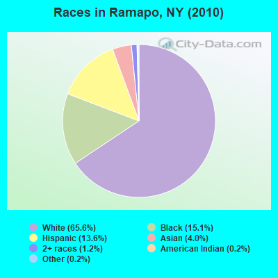
Races in Ramapo detailed stats: ancestries, foreign born residents, place of birth
The City-Data.com crime index weighs serious crimes and violent crimes more heavily. Higher means more crime, U.S. average is 246.1. It adjusts for the number of visitors and daily workers commuting into cities.
- means the value is smaller than the state average.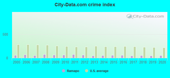
Crime rate in Ramapo detailed stats: murders, rapes, robberies, assaults, burglaries, thefts, arson
Full-time law enforcement employees in 2021, including police officers: 118 (101 officers - 89 male; 12 female).
| Officers per 1,000 residents here: | 1.05 |
| New York average: | 3.28 |
 Recent articles from our blog. Our writers, many of them Ph.D. graduates or candidates, create easy-to-read articles on a wide variety of topics.

 | Upper Middle class african-american communities in ny (2035 replies) |
| East Ramapo school board awarded $76M in contracts to nonprofit led by influential rabbi (0 replies) |
| smaller Upstate NY cities and towns/African American communities (5956 replies) |
| For those interested in state political issues (424 replies) |
| Graduation videos… (38 replies) |
| What is it like living in Suffern 10901? (3 replies) |
Latest news from Ramapo, NY collected exclusively by city-data.com from local newspapers, TV, and radio stations
Ancestries: Italian (9.2%), West Indian (8.9%), Irish (7.9%), United States (6.2%), Polish (5.6%), German (5.2%).
Current Local Time: EST time zone
Elevation: 314 feet
Land area: 61.2 square miles.
Population density: 2,067 people per square mile (low).
24,848 residents are foreign born (11.3% Latin America, 5.3% Europe, 5.2% Asia).
| This town: | 22.8% |
| New York: | 20.4% |
| Ramapo town: | 2.8% ($6,184) |
| New York: | 1.9% ($2,847) |
Nearest city with pop. 200,000+: Bronx, NY  (22.0 miles , pop. 1,332,650).
Nearest cities:
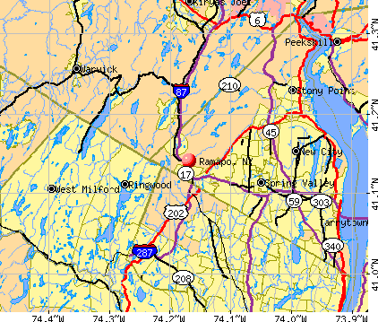
), ), ), ), )Latitude: 41.12 N, Longitude: 74.08 W

Ramapo, New York accommodation & food services, waste management - Economy and Business Data
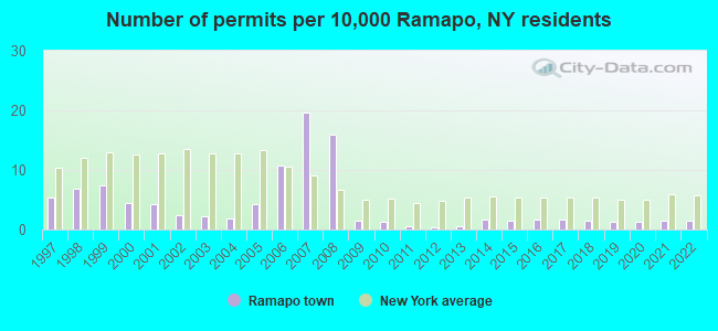
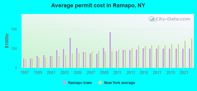
Single-family new house construction building permits:
- 2022: 16 buildings, average cost: $253,500
- 2021: 17 buildings, average cost: $253,500
- 2020: 14 buildings, average cost: $253,500
- 2019: 15 buildings, average cost: $253,500
- 2018: 17 buildings, average cost: $253,500
- 2017: 18 buildings, average cost: $253,600
- 2016: 19 buildings, average cost: $253,100
- 2015: 17 buildings, average cost: $255,300
- 2014: 18 buildings, average cost: $241,000
- 2013: 7 buildings, average cost: $233,900
- 2012: 4 buildings, average cost: $236,600
- 2011: 6 buildings, average cost: $220,300
- 2010: 14 buildings, average cost: $465,200
- 2009: 16 buildings, average cost: $264,800
- 2008: 174 buildings, average cost: $187,300
- 2007: 214 buildings, average cost: $189,200
- 2006: 116 buildings, average cost: $214,100
- 2005: 47 buildings, average cost: $258,700
- 2004: 21 buildings, average cost: $389,300
- 2003: 24 buildings, average cost: $250,000
- 2002: 27 buildings, average cost: $234,300
- 2001: 47 buildings, average cost: $155,700
- 2000: 48 buildings, average cost: $168,900
- 1999: 80 buildings, average cost: $156,300
- 1998: 74 buildings, average cost: $127,600
- 1997: 59 buildings, average cost: $127,400
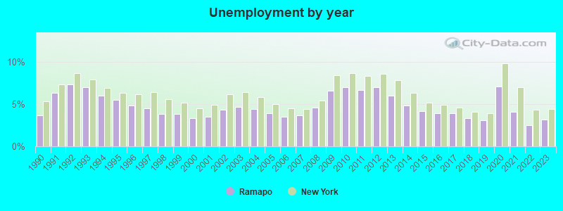
| Here: | 3.2% |
| New York: | 4.4% |
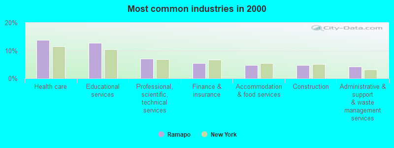
- Health care (13.8%)
- Educational services (12.7%)
- Professional, scientific, technical services (7.0%)
- Finance & insurance (5.5%)
- Accommodation & food services (4.7%)
- Construction (4.7%)
- Administrative & support & waste management services (4.3%)
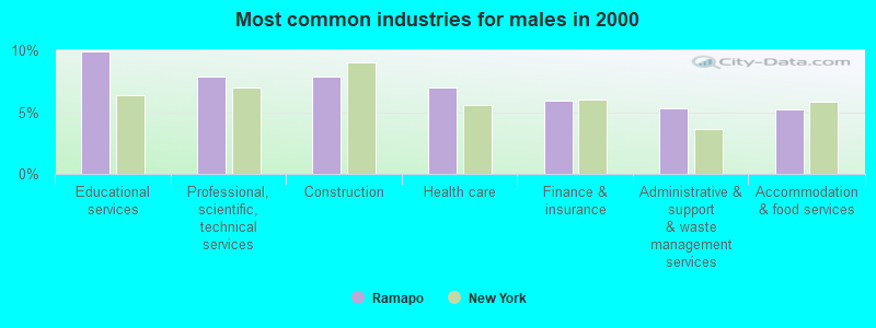
- Educational services (9.9%)
- Professional, scientific, technical services (7.9%)
- Construction (7.9%)
- Health care (7.0%)
- Finance & insurance (5.9%)
- Administrative & support & waste management services (5.3%)
- Accommodation & food services (5.2%)
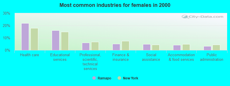
- Health care (21.9%)
- Educational services (16.1%)
- Professional, scientific, technical services (6.0%)
- Finance & insurance (5.1%)
- Social assistance (4.9%)
- Accommodation & food services (4.1%)
- Public administration (3.3%)
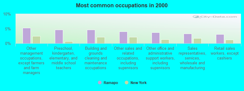
- Other management occupations, except farmers and farm managers (5.3%)
- Preschool, kindergarten, elementary, and middle school teachers (4.7%)
- Building and grounds cleaning and maintenance occupations (4.6%)
- Other sales and related occupations, including supervisors (4.0%)
- Other office and administrative support workers, including supervisors (3.7%)
- Sales representatives, services, wholesale and manufacturing (3.3%)
- Retail sales workers, except cashiers (3.1%)
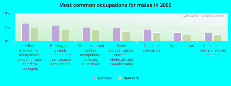
- Other management occupations, except farmers and farm managers (6.4%)
- Building and grounds cleaning and maintenance occupations (5.7%)
- Other sales and related occupations, including supervisors (4.9%)
- Sales representatives, services, wholesale and manufacturing (4.7%)
- Computer specialists (4.2%)
- Top executives (3.1%)
- Retail sales workers, except cashiers (2.9%)
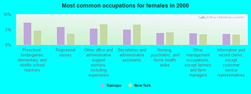
- Preschool, kindergarten, elementary, and middle school teachers (7.5%)
- Registered nurses (6.0%)
- Other office and administrative support workers, including supervisors (5.4%)
- Secretaries and administrative assistants (5.2%)
- Nursing, psychiatric, and home health aides (4.0%)
- Other management occupations, except farmers and farm managers (3.9%)
- Information and record clerks, except customer service representatives (3.7%)
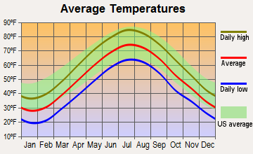
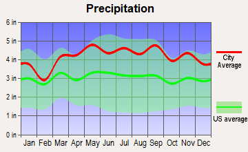
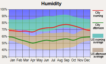
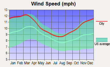
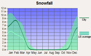
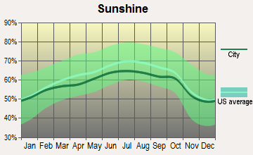
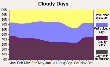
Average climate in Ramapo, New York
Based on data reported by over 4,000 weather stations
(lower is better)
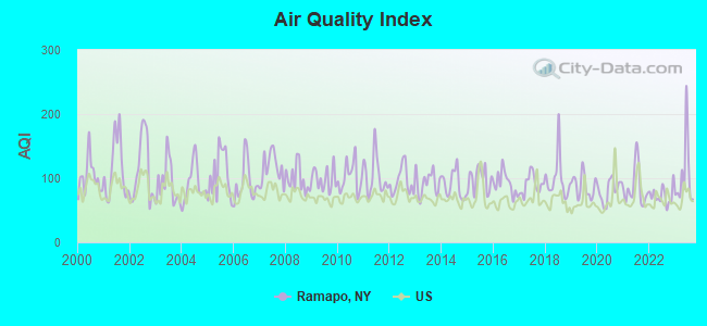
Air Quality Index (AQI) level in 2023 was 103. This is significantly worse than average.
| City: | 103 |
| U.S.: | 73 |
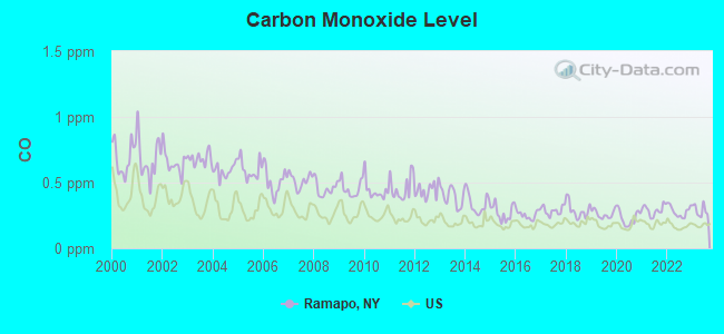
Carbon Monoxide (CO) [ppm] level in 2023 was 0.287. This is about average. Closest monitor was 13.9 miles away from the city center.
| City: | 0.287 |
| U.S.: | 0.251 |
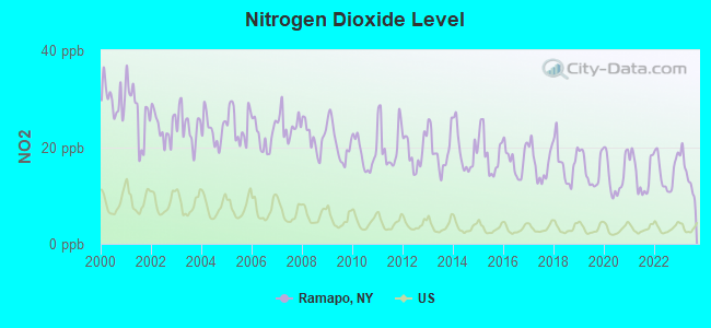
Nitrogen Dioxide (NO2) [ppb] level in 2023 was 14.4. This is significantly worse than average. Closest monitor was 13.6 miles away from the city center.
| City: | 14.4 |
| U.S.: | 5.1 |
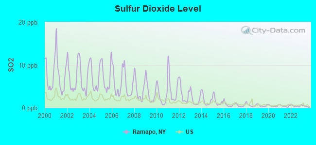
Sulfur Dioxide (SO2) [ppb] level in 2023 was 0.394. This is significantly better than average. Closest monitor was 5.2 miles away from the city center.
| City: | 0.394 |
| U.S.: | 1.515 |
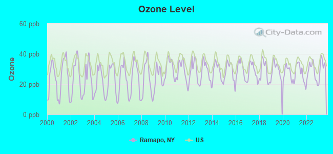
Ozone [ppb] level in 2023 was 30.9. This is about average. Closest monitor was 5.1 miles away from the city center.
| City: | 30.9 |
| U.S.: | 33.3 |
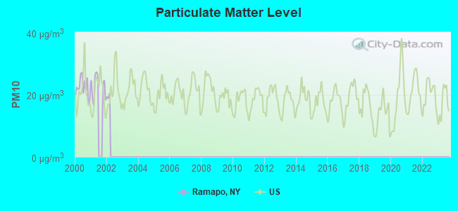
Particulate Matter (PM10) [µg/m3] level in 2001 was 22.6. This is about average. Closest monitor was 3.8 miles away from the city center.
| City: | 22.6 |
| U.S.: | 19.2 |
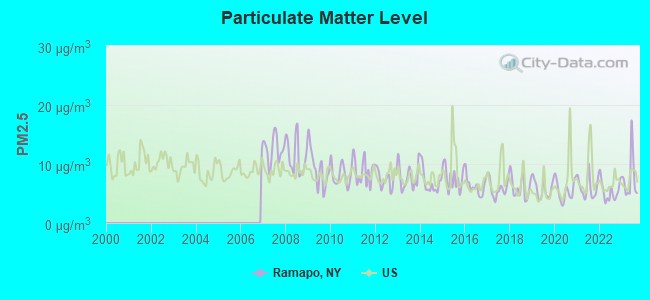
Particulate Matter (PM2.5) [µg/m3] level in 2023 was 7.54. This is about average. Closest monitor was 14.8 miles away from the city center.
| City: | 7.54 |
| U.S.: | 8.11 |
Tornado activity:
Ramapo-area historical tornado activity is above New York state average. It is 35% smaller than the overall U.S. average.
On 7/14/1988, a category F3 (max. wind speeds 158-206 mph) tornado 24.7 miles away from the Ramapo town center injured one person and caused between $500,000 and $5,000,000 in damages.
On 5/28/1973, a category F3 tornado 31.1 miles away from the town center caused between $50,000 and $500,000 in damages.
Earthquake activity:
Ramapo-area historical earthquake activity is significantly above New York state average. It is 68% smaller than the overall U.S. average.On 10/7/1983 at 10:18:46, a magnitude 5.3 (5.1 MB, 5.3 LG, 5.1 ML, Class: Moderate, Intensity: VI - VII) earthquake occurred 196.3 miles away from the city center
On 8/23/2011 at 17:51:04, a magnitude 5.8 (5.8 MW, Depth: 3.7 mi) earthquake occurred 302.6 miles away from the city center
On 4/20/2002 at 10:50:47, a magnitude 5.3 (5.3 ML, Depth: 3.0 mi) earthquake occurred 235.3 miles away from the city center
On 4/20/2002 at 10:50:47, a magnitude 5.2 (5.2 MB, 4.2 MS, 5.2 MW, 5.0 MW) earthquake occurred 233.5 miles away from Ramapo center
On 1/16/1994 at 01:49:16, a magnitude 4.6 (4.6 MB, 4.6 LG, Depth: 3.1 mi, Class: Light, Intensity: IV - V) earthquake occurred 116.1 miles away from Ramapo center
On 1/19/1982 at 00:14:42, a magnitude 4.7 (4.5 MB, 4.7 MD, 4.5 LG) earthquake occurred 207.8 miles away from Ramapo center
Magnitude types: regional Lg-wave magnitude (LG), body-wave magnitude (MB), duration magnitude (MD), local magnitude (ML), surface-wave magnitude (MS), moment magnitude (MW)
Natural disasters:
The number of natural disasters in Rockland County (23) is greater than the US average (15).Major Disasters (Presidential) Declared: 14
Emergencies Declared: 8
Causes of natural disasters: Hurricanes: 7, Floods: 6, Storms: 6, Blizzards: 2, Heavy Rains: 2, Tropical Storms: 2, Landslide: 1, Power Outage: 1, Snowstorm: 1, Water Shortage: 1, Other: 3 (Note: some incidents may be assigned to more than one category).
Hospitals and medical centers near Ramapo:
- NORTHERN METROPOLITAN R H C F INC (Nursing Home, about 1 miles away; MONSEY, NY)
- JAWONIO, INC. (Hospital, about 2 miles away; WESLEY HILLS, NY)
- JAWONIO, INC. (Hospital, about 2 miles away; MONSEY, NY)
- CAMP VENTURE, INC (Hospital, about 2 miles away; MONSEY, NY)
- ROCKLAND COUNTY CHAPTER NYS ARC (Hospital, about 3 miles away; POMONA, NY)
- PINE VALLEY CENTER FOR REHAB AND NURSING (Nursing Home, about 3 miles away; SPRING VALLEY, NY)
- AMERICARE CERTIFIED SPECIAL SERVICES SUB-UNIT (Home Health Center, about 3 miles away; SUFFERN, NY)
Amtrak stations near Ramapo:
- 12 miles: CROTON-HARMON (CROTON-ON-HUDSON, CROTON POINT AVE.) . Services: partially wheelchair accessible, enclosed waiting area, public restrooms, public payphones, snack bar, paid short-term parking, paid long-term parking, call for car rental service, call for taxi service, public transit connection.
- 16 miles: YONKERS (FOOT OF DOCK ST. & WELLS AVE.) . Services: fully wheelchair accessible, enclosed waiting area, public restrooms, public payphones, snack bar, paid short-term parking, paid long-term parking, call for car rental service, taxi stand, public transit connection.
Operable nuclear power plants near Ramapo:
- 13 miles: Indian Point 2 and 3 in Buchanan, NY.
Colleges/universities with over 2000 students nearest to Ramapo:
- Rockland Community College (about 1 miles; Suffern, NY; Full-time enrollment: 6,026)
- Ramapo College of New Jersey (about 9 miles; Mahwah, NJ; FT enrollment: 5,864)
- Nyack College (about 9 miles; Nyack, NY; FT enrollment: 2,590)
- Bergen Community College (about 12 miles; Paramus, NJ; FT enrollment: 11,826)
- Mercy College (about 13 miles; Dobbs Ferry, NY; FT enrollment: 8,602)
- William Paterson University of New Jersey (about 14 miles; Wayne, NJ; FT enrollment: 10,198)
- Passaic County Community College (about 15 miles; Paterson, NJ; FT enrollment: 6,351)
Points of interest:
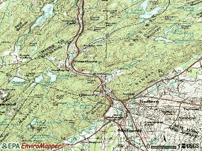
Notable locations in Ramapo: New York Country Club (A), Cedar Hollow Country Club (B), Kanes Open Camp (C), Minisceogo Golf Course (D), Rockland County Health and Social Services Complex (E), Masonic Camp (F), Spook Rock Golf Course (G), Monsey Station (H), Ramapo Rest Area (I), Sloatsburg Rest Area (J), Vacation Camp for the Blind (K), Duryea Farm (L), Matterhorn Nursery (M), Orchards of Concklin (N), Brucker Hall (O), Saint Joseph Adult Care Home (P), Doctor Robert L Yeager Center (Q), Hillcrest Fire Company 1 (R), Spring Valley Fire Department Columbian Engine Company 1 (S), Finkelstein Memorial Library (T). Display/hide their locations on the map
Churches in Ramapo include: New Life Pentecostal Church (A), Sons of Israel Synagogue (B), Saint Paul's African Methodist Episcopal Church (C), Saint James Greek Orthodox Church (D), First Baptist Church (E), Church of the Nazarene (F), Saint Joseph's Church (G), United Church of Spring Valley (H), First Congregational Church (I). Display/hide their locations on the map
Cemeteries: Maple Grove Cemetery (1), Airmont Cemetery (2). Display/hide their locations on the map
Lakes, reservoirs, and swamps: Mirror Lake (A), Pine Meadow Lake (B), Lake Wanoksink (C), Lake Antrim (D), Bockar Lake (E), Monsey Lake (F), Potake Pond (G), Hillburn Reservoir (H). Display/hide their locations on the map
Streams, rivers, and creeks: Stony Brook (A), Torne Brook (B), Pine Meadow Brook (C), Diamond Creek (D), Spring Brook (E). Display/hide their locations on the map
Parks in Ramapo include: Capital Park (1), Dater Mountain County Park (2), Dexter Park (3), Fairway Park (4), Kings Gate Park (5), Lorna Lane Park (6), Memorial Park (7), Mount Ivy County Park (8), Pine Brook Farms Park (9). Display/hide their locations on the map
| This town: | 3.6 people |
| New York: | 2.6 people |
| This town: | 78.5% |
| Whole state: | 63.5% |
| This town: | 3.6% |
| Whole state: | 6.8% |
Likely homosexual households (counted as self-reported same-sex unmarried-partner households)
- Lesbian couples: 0.4% of all households
- Gay men: 0.3% of all households
| This town: | 16.3% |
| Whole state: | 14.6% |
| This town: | 9.0% |
| Whole state: | 7.4% |
People in group quarters in Ramapo in 2010:
- 936 people in nursing facilities/skilled-nursing facilities
- 388 people in group homes intended for adults
- 374 people in workers' group living quarters and job corps centers
- 221 people in other noninstitutional facilities
- 195 people in college/university student housing
- 80 people in residential treatment centers for adults
- 25 people in emergency and transitional shelters (with sleeping facilities) for people experiencing homelessness
- 16 people in group homes for juveniles (non-correctional)
- 9 people in mental (psychiatric) hospitals and psychiatric units in other hospitals
People in group quarters in Ramapo in 2000:
- 1,233 people in nursing homes
- 274 people in homes for the mentally retarded
- 268 people in homes for the mentally ill
- 264 people in other noninstitutional group quarters
- 169 people in residential treatment centers for emotionally disturbed children
- 166 people in college dormitories (includes college quarters off campus)
- 109 people in other group homes
- 57 people in religious group quarters
- 36 people in other nonhousehold living situations
- 18 people in schools, hospitals, or wards for the intellectually disabled
- 16 people in homes for the physically handicapped
- 13 people in unknown juvenile institutions
- 8 people in training schools for juvenile delinquents
For population 15 years and over in Ramapo:
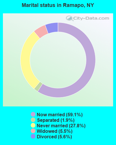
- Never married: 27.8%
- Now married: 59.1%
- Separated: 1.9%
- Widowed: 5.5%
- Divorced: 5.6%
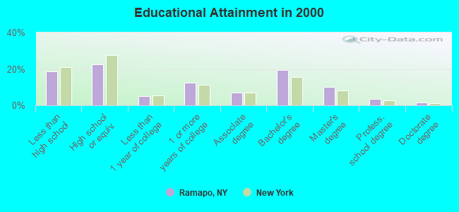
For population 25 years and over in Ramapo:
- High school or higher: 81.5%
- Bachelor's degree or higher: 34.5%
- Graduate or professional degree: 15.1%
- Unemployed: 4.3%
- Mean travel time to work (commute): 33.0 minutes
| Here: | 14.3 |
| New York average: | 14.2 |
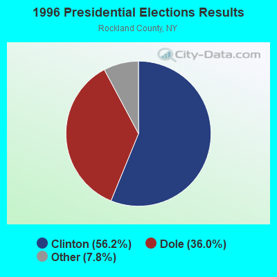
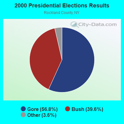
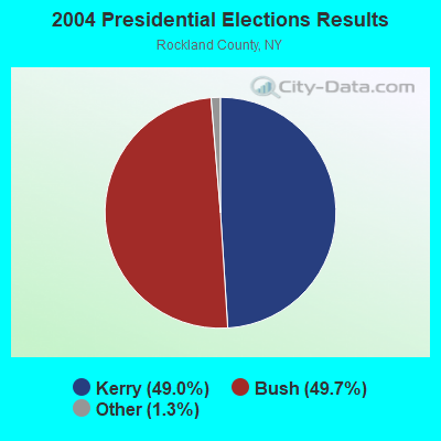
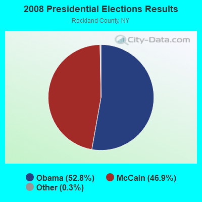
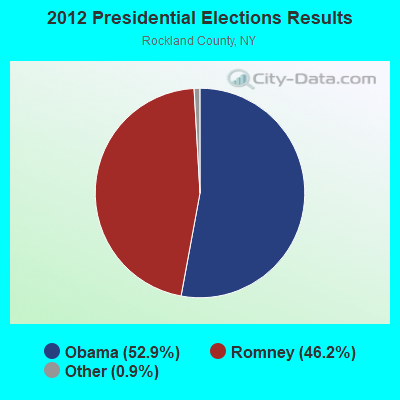
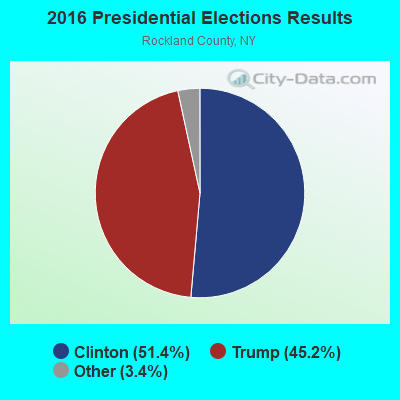
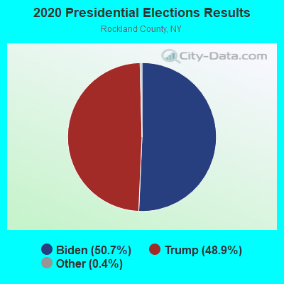
Graphs represent county-level data. Detailed 2008 Election Results
Religion statistics for Ramapo, NY (based on Rockland County data)
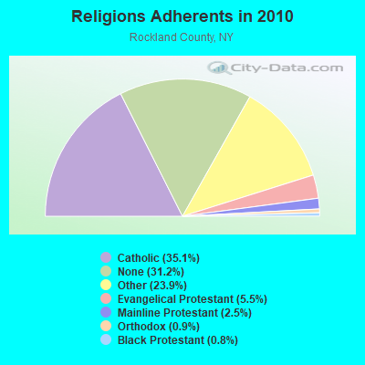
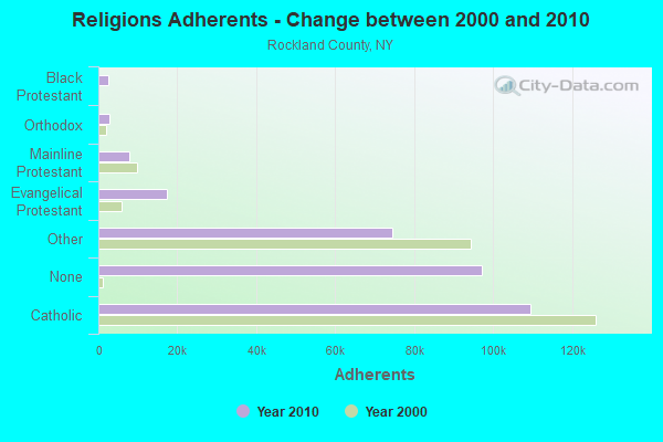
| Religion | Adherents | Congregations |
|---|---|---|
| Catholic | 109,386 | 21 |
| Other | 74,477 | 136 |
| Evangelical Protestant | 17,221 | 84 |
| Mainline Protestant | 7,852 | 48 |
| Orthodox | 2,909 | 14 |
| Black Protestant | 2,640 | 8 |
| None | 97,202 | - |
Food Environment Statistics:
| Rockland County: | 3.20 / 10,000 pop. |
| State: | 4.13 / 10,000 pop. |
| Rockland County: | 0.07 / 10,000 pop. |
| New York: | 0.06 / 10,000 pop. |
| Rockland County: | 1.21 / 10,000 pop. |
| New York: | 0.92 / 10,000 pop. |
| This county: | 0.98 / 10,000 pop. |
| New York: | 1.68 / 10,000 pop. |
| Rockland County: | 9.70 / 10,000 pop. |
| State: | 8.82 / 10,000 pop. |
| This county: | 8.7% |
| New York: | 8.2% |
| This county: | 24.1% |
| State: | 23.8% |
| Here: | 11.0% |
| New York: | 15.6% |
5.89% of this county's 2020 resident taxpayers moved to other counties in 2021 ($101,456 average adjusted gross income)
| Here: | 5.89% |
| New York average: | 6.93% |
0.02% of residents moved to foreign countries ($114 average AGI)
Rockland County: 0.02% New York average: 0.02%
Top counties to which taxpayers relocated from this county between 2020 and 2021:
| to Bergen County, NJ | |
| to Orange County, NY | |
| to Westchester County, NY |
Businesses in Ramapo, NY
- McDonald's: 1
Strongest AM radio stations in Ramapo:
- WABC (770 AM; 50 kW; NEW YORK, NY; Owner: WABC-AM RADIO, INC.)
- WVNJ (1160 AM; 20 kW; OAKLAND, NJ; Owner: UNIVERSAL B/CASTING OF NEW YORK,INC.)
- WOR (710 AM; 50 kW; NEW YORK, NY; Owner: BUCKLEY BROADCASTING CORPORATION)
- WFAN (660 AM; 50 kW; NEW YORK, NY; Owner: INFINITY BROADCASTING OPERATIONS, INC.)
- WMCA (570 AM; 50 kW; NEW YORK, NY; Owner: SALEM MEDIA OF NEW YORK, LLC)
- WINS (1010 AM; 50 kW; NEW YORK, NY; Owner: INFINITY BROADCASTING OPERATIONS, INC.)
- WSNR (620 AM; 20 kW; JERSEY CITY, NJ)
- WEPN (1050 AM; 50 kW; NEW YORK, NY; Owner: NEW YORK AM RADIO, LLC)
- WCBS (880 AM; 50 kW; NEW YORK, NY; Owner: INFINITY BROADCASTING OPERATIONS, INC.)
- WBBR (1130 AM; 50 kW; NEW YORK, NY; Owner: BLOOMBERG COMMUNICATIONS INC.)
- WADO (1280 AM; 50 kW; NEW YORK, NY; Owner: WADO-AM LICENSE CORP.)
- WRKL (910 AM; 1 kW; NEW CITY, NY; Owner: POLNET COMMUNICATIONS, LTD.)
- WLIB (1190 AM; 30 kW; NEW YORK, NY; Owner: ICBC BROADCAST HOLDINGS-NY, INC.)
Strongest FM radio stations in Ramapo:
- WPLJ (95.5 FM; NEW YORK, NY; Owner: WPLJ-FM RADIO, INC.)
- WNYK (88.7 FM; NYACK, NY; Owner: NYACK COLLEGE)
- WKCR-FM (89.9 FM; NEW YORK, NY; Owner: TRUSTEES OF COLUMBIA UNIVERSITY IN NEW YORK)
- WLJP (89.3 FM; MONROE, NY; Owner: SOUND OF LIFE, INC.)
- WNEW (102.7 FM; NEW YORK, NY; Owner: INFINITY BROADCASTING OPERATIONS, INC.)
- WKTU (103.5 FM; LAKE SUCCESS, NY; Owner: AMFM RADIO LICENSES, LLC)
- WRKS (98.7 FM; NEW YORK, NY; Owner: EMMIS RADIO LICENSE CORP OF NEW YORK)
- WFAS-FM (103.9 FM; WHITE PLAINS, NY; Owner: CUMULUS LICENSING CORP.)
- WQCD (101.9 FM; NEW YORK, NY; Owner: EMMIS RADIO LICENSE CORPORATION)
- WAXQ (104.3 FM; NEW YORK, NY; Owner: AMFM NEW YORK LICENSES, LLC)
- WHTZ (100.3 FM; NEWARK, NJ; Owner: AMFM RADIO LICENSES, L.L.C.)
- WWPR-FM (105.1 FM; NEW YORK, NY; Owner: AMFM RADIO LICENSES, L.L.C.)
- WCBS-FM (101.1 FM; NEW YORK, NY; Owner: INFINITY BROADCASTING OPERATIONS, INC.)
- WCAA (105.9 FM; NEWARK, NJ; Owner: WADO-AM LICENSE CORP. ("WADO"))
- WBAI (99.5 FM; NEW YORK, NY; Owner: PACIFICA FOUNDATION, INC.)
- WBLS (107.5 FM; NEW YORK, NY; Owner: ICBC BROADCAST HOLDINGS-NY, INC.)
- WLTW (106.7 FM; NEW YORK, NY; Owner: AMFM NEW YORK LICENSES, LLC)
- WQXR-FM (96.3 FM; NEW YORK, NY; Owner: THE NEW YORK TIMES ELECTRONIC MEDIA COMPANY)
- WSKQ-FM (97.9 FM; NEW YORK, NY; Owner: WSKQ LICENSING, INC.)
- WXRK (92.3 FM; NEW YORK, NY; Owner: INFINITY BROADCASTING OPERATIONS, INC.)
TV broadcast stations around Ramapo:
- WFME-TV (Channel 66; WEST MILFORD, NJ; Owner: FAMILY STATIONS, INC.)
- WNYW (Channel 5; NEW YORK, NY; Owner: FOX TELEVISION STATIONS, INC.)
- WCBS-TV (Channel 2; NEW YORK, NY; Owner: CBS BROADCASTING INC.)
- WABC-TV (Channel 7; NEW YORK, NY; Owner: AMERICAN BROADCASTING COMPANIES, INC)
- WPIX (Channel 11; NEW YORK, NY; Owner: WPIX, INC.)
- WWOR-TV (Channel 9; SECAUCUS, NJ; Owner: FOX TELEVISION STATIONS, INC.)
- W68DN (Channel 68; CHERRY HILL, ETC., NJ; Owner: MARCIA COHEN)
- WNJU (Channel 47; LINDEN, NJ; Owner: WNJU LICENSE CORPORATION)
- WFUT (Channel 68; NEWARK, NJ; Owner: UNIVISION NEW YORK LLC)
- WPXN-TV (Channel 31; NEW YORK, NY; Owner: PAXSON COMMUNICATIONS LICENSE COMPANY, LLC)
- WXNY-LP (Channel 32; NEW YORK, NY; Owner: ISLAND BROADCASTING COMPANY)
- WPXO-LP (Channel 34; EAST ORANGE, NJ; Owner: PAXSON COMMUNICATIONS LPTV, INC.)
- WNYE-TV (Channel 25; NEW YORK, NY; Owner: NEW YORK CITY BOARD OF EDUCATION)
- WNBC (Channel 4; NEW YORK, NY; Owner: NATIONAL BROADCASTING COMPANY, INC.)
- WNET (Channel 13; NEWARK, NJ; Owner: EDUCATIONAL BROADCASTING CORPORATION)
- WXTV (Channel 41; PATERSON, NJ; Owner: WXTV LICENSE PARTNERSHIP, G.P.)
- WKOB-LP (Channel 53; NEW YORK, NY; Owner: WKOB COMMUNICATIONS, INC.)
- WEBR-CA (Channel 17; MANHATTAN, NY; Owner: K LICENSEE INC.)
- WRNN-LP (Channel 57; NYACK, NY; Owner: LP NYACK LIMITED PARTNERSHIP)
- W60AI (Channel 60; NEW YORK, NY; Owner: VENTANA TELEVISION, INC.)
- WTBY (Channel 54; POUGHKEEPSIE, NY; Owner: TRINITY BROADCASTING OF NEW YORK, INC.)
- W38CL (Channel 38; BRONX, NY; Owner: RENARD COMMUNICATIONS CORP.)
- WNXY-LP (Channel 26; NEW YORK, NY; Owner: ISLAND BROADCASTING COMPANY)
- W33BS (Channel 33; DARIEN, CT; Owner: CT&T BROADCASTING, INC.)
- WNYN-LP (Channel 39; NEW YORK, NY; Owner: ISLAND BROADCASTING COMPANY)
- National Bridge Inventory (NBI) Statistics
- 34Number of bridges
- 397ft / 121mTotal length
- $142,953,000Total costs
- 950,726Total average daily traffic
- 57,918Total average daily truck traffic
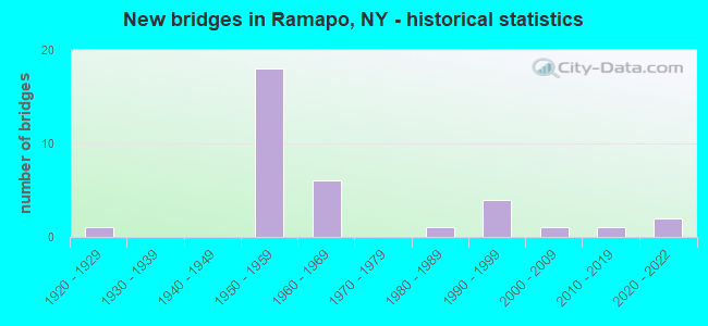
- New bridges - historical statistics
- 11920-1929
- 181950-1959
- 61960-1969
- 11980-1989
- 41990-1999
- 12000-2009
- 12010-2019
- 22020-2022
FCC Registered Antenna Towers:
6- John Throckmorton, 631 Route 306 (Lat: 41.177278 Lon: -74.068278), Type: 50.3, Structure height: 36087 m, Overall height: 45.7 m, Registrant: Municipal Communications, LLC, Jthrockmorton@municipalcom.Com, Bldg 11 Suite 411, Atlan-ta, Phone: (404) 995-1893
- John Throckmorton, 631 Route 306 (Lat: 41.177278 Lon: -74.068278), Type: 50.3, Structure height: 36087 m, Overall height: 45.7 m, Registrant: Municipal Communications, LLC, Jthrockmorton@municipalcom.Com, Bldg 11 Suite 411, Atlan-ta, Phone: (404) 995-1893
- John Throckmorton, 631 Route 306 (Lat: 41.177278 Lon: -74.068278), Type: 50.3, Structure height: 36087 m, Overall height: 45.7 m, Registrant: Municipal Communications, LLC, Jthrockmorton@municipalcom.Com, Bldg 11 Suite 411, Atlan-ta, Phone: (404) 995-1893
- Alyse Brussard, 631 Route 306 (Lat: 41.177278 Lon: -74.068278), Type: 50.3, Structure height: 36087 m, Overall height: 45.7 m, Registrant: American Towers LLC, Faa-Fcc@americantower.Com, , Wobur-n, Phone: (781) 926-4500
- Courtney Schoonover, 631 Route 306 (284987) (Lat: 41.177278 Lon: -74.068278), Type: 50.3, Structure height: 36087 m, Overall height: 47.2 m, Registrant: American Towers LLC, Faa-Fcc@americantower.Com, , Wobur-n, Phone: (781) 926-4500
- Courtney Schoonover, 631 Route 306 (284987) (Lat: 41.177278 Lon: -74.068278), Type: 50.3, Structure height: 36087 m, Overall height: 47.2 m, Registrant: American Towers LLC, Faa-Fcc@americantower.Com, , Wobur-n, Phone: (781) 926-4500
FCC Registered Broadcast Land Mobile Towers:
2- SLOATSBURG, Sloatsburg Service Area Nys Thruway Mp 33.0 (Lat: 41.149056 Lon: -74.187806), Type: Mtower, Structure height: 36.6 m, Overall height: 39.6 m, Call Sign: KRA529,
Assigned Frequencies: 453.425 MHz, 453.525 MHz, Grant Date: 11/17/2023, Expiration Date: 01/27/2034, Registrant: New York State Thruway Authority, 200 Southern Blvd., Bldg. 11, Albany, NY 12209, Phone: (518) 471-4436, Fax: (518) 436-3068, Email:
- HILL TOP PLACE, 10 Hilltop Pl (Lat: 41.120278 Lon: -74.084750), Type: Pole, Structure height: 15.2 m, Overall height: 23.5 m, Call Sign: WRKV773,
Assigned Frequencies: 772.331 MHz, 771.593 MHz, Grant Date: 02/22/2021, Expiration Date: 02/22/2031, Certifier: Sylvain Klein, Registrant: Vcomm, L.L.C., 2540 Us Highway 130, Suite 101, Cranbury, NJ 08512, Phone: (800) 930-4307, Fax: (609) 409-1927, Email:
FCC Registered Microwave Towers:
3- Various Locations (Lat: 41.150083 Lon: -74.166250), Overall height: 6.1 m, Call Sign: WPJC827,
Assigned Frequencies: 956.256 MHz, Grant Date: 03/23/2011, Expiration Date: 03/05/2021, Cancellation Date: 05/08/2021, Registrant: Blooston, Mordkofsky, Dickens, Duffy & Prendergast, LLP, 2120 L Street, N.W., Suite 300, Washington, DC 20037, Phone: (202) 828-5536, Fax: (202) 828-5568
- NY06XC478, 430 New Hemstead Rd. (Lat: 41.150639 Lon: -74.027806), Type: Mtower, Structure height: 38.1 m, Overall height: 39.3 m, Call Sign: WQQQ271,
Assigned Frequencies: 10935.0 MHz, 10935.0 MHz, 10935.0 MHz, Grant Date: 02/12/2013, Expiration Date: 02/12/2023, Cancellation Date: 08/01/2014, Certifier: Kyle B Entz, Registrant: Sprint Nextel Corporation, 12502 Sunrise Valley Drive, Reston, VA 20196, Phone: (703) 433-4000, Fax: (703) 433-4483
- Ramapo, Torn Valley Rd. 3 Mi. Ne Of Jct. Of Rt. 17 & 59 (Lat: 41.150083 Lon: -74.155139), Type: Tower, Structure height: 18.3 m, Call Sign: WAA717,
Assigned Frequencies: 6615.00 MHz, Grant Date: 10/26/2020, Expiration Date: 10/18/2030, Registrant: Blooston, Mordkofsky, Dickens & Prendergast, LLP, 2120 L Street, N.W., Suite 825, Washington, DC 20037, Phone: (202) 828-5565, Fax: (202) 828-5568, Email:
FCC Registered Paging Towers:
3- 20 Secora Road (Lat: 41.108417 Lon: -74.057917), Type: Tower, Structure height: 32 m, Call Sign: KNKM812, Licensee ID: L01422065,
Assigned Frequencies: 931.837 MHz, Grant Date: 09/03/2008, Expiration Date: 07/01/2018, Cancellation Date: 01/28/2014, Certifier: Shawn E Endsley, Registrant: Usa Mobility Wireless, Inc., 3000 Technology Dr. #400, Plano, TX 75074, Phone: (972) 801-0000, Fax: (972) 801-1699, Email:
- 20 Secora Road (Lat: 41.108417 Lon: -74.057917), Structure height: 30.1 m, Call Sign: KRS674,
Assigned Frequencies: 454.100 MHz, Grant Date: 05/11/1999, Expiration Date: 04/01/2009, Cancellation Date: 11/15/2004, Certifier: Paul H Kuzia, Registrant: Wilkinson Barker Knaurer, LLP, 2300 N Street, N.W. 7th Floor, Washington, DC 20037, Phone: (202) 783-4141, Fax: (202) 783-5851, Email:
- Mark Drive (Lat: 41.154528 Lon: -74.061250), Type: Building, Structure height: 7.6 m, Overall height: 13.4 m, Call Sign: WXS346,
Assigned Frequencies: 473.012 MHz, 473.037 MHz, 473.062 MHz, 473.087 MHz, 473.112 MHz, Grant Date: 05/18/1999, Expiration Date: 04/01/2009, Cancellation Date: 10/20/2003, Registrant: Fletcher, Heald, & Hildreth, 1300 North 17th St, 11th Floor, Rosslyn, VA 22209, Phone: (703) 812-0400, Fax: (703) 812-0486, Email:
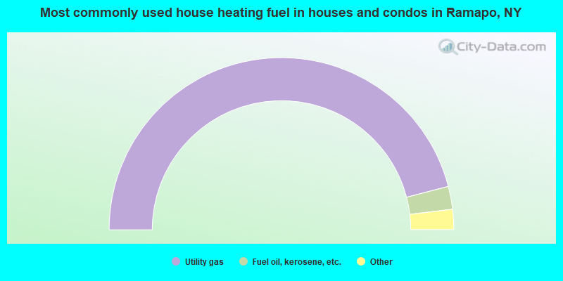
- 92.0%Utility gas
- 4.3%Fuel oil, kerosene, etc.
- 2.6%Electricity
- 0.6%Bottled, tank, or LP gas
- 0.2%No fuel used
- 0.2%Wood
- 0.1%Other fuel
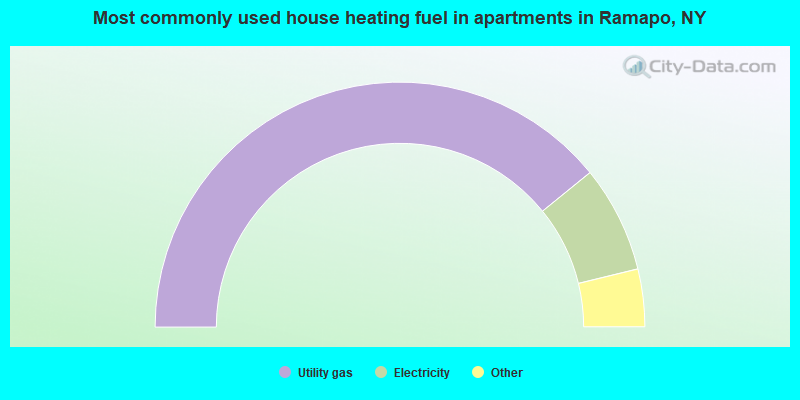
- 78.3%Utility gas
- 14.1%Electricity
- 3.9%Fuel oil, kerosene, etc.
- 2.1%Bottled, tank, or LP gas
- 1.1%No fuel used
- 0.5%Other fuel
Ramapo compared to New York state average:
- Unemployed percentage significantly below state average.
- Median age significantly below state average.
- Length of stay since moving in significantly above state average.
- Number of rooms per house significantly below state average.
- House age significantly below state average.
Ramapo, NY compared to other similar cities:
Ramapo on our top lists:
- #1 on the list of "Top 101 cities with largest percentage of males in occupations: other teachers and instructors, education, training, and library occupations (population 50,000+)"
- #1 on the list of "Top 101 cities with largest percentage of females in occupations: therapists (population 50,000+)"
- #2 on the list of "Top 101 cities with the largest percentage of elementary and middle school students in private schools (5,000+ students)"
- #2 on the list of "Top 101 cities with the largest percentage of high school students in private schools (3,000+ students)"
- #3 on the list of "Top 101 cities with largest percentage of males in occupations: preschool, kindergarten, elementary and middle school teachers (population 50,000+)"
- #3 on the list of "Top 101 cities with largest percentage of males in occupations: religious workers (population 50,000+)"
- #3 on the list of "Top 101 cities with largest percentage of females in occupations: motor vehicle operators except bus and truck drivers (population 50,000+)"
- #3 on the list of "Top 101 cities with largest percentage of males in occupations: special education teachers (population 50,000+)"
- #4 on the list of "Top 101 cities with largest percentage of females in industries: health care (population 50,000+)"
- #4 on the list of "Top 101 cities with largest percentage of males in industries: religious, grantmaking, civic, professional, and similar organizations (population 50,000+)"
- #4 on the list of "Top 101 larger cities with the highest real estate taxes percentage (population 50,000+)"
- #6 on the list of "Top 101 cities with largest percentage of males in industries: miscellaneous durable goods merchant wholesalers (population 50,000+)"
- #6 on the list of "Top 101 cities with the most people below 50% of the poverty level, excluding cities with 15% or more of residents in college and with the median age below 28 (population 50,000+)"
- #7 on the list of "Top 101 cities with largest percentage of males in industries: gasoline stations (population 50,000+)"
- #7 on the list of "Top 101 cities with largest percentage of males in industries: vending machine operators (population 50,000+)"
- #8 on the list of "Top 101 cities with largest percentage of females in industries: social assistance (population 50,000+)"
- #8 on the list of "Top 101 cities with largest percentage of males in industries: apparel, fabrics, and notions merchant wholesalers (population 50,000+)"
- #9 on the list of "Top 101 cities with largest percentage of males in industries: health and personal care, except drug, stores (population 50,000+)"
- #9 on the list of "Top 101 cities with largest percentage of females in industries: chemicals (population 50,000+)"
- #9 on the list of "Top 101 cities with largest percentage of males in industries: textile mills and textile products (population 50,000+)"
- #3 (10952) on the list of "Top 101 zip codes with the largest charity contributions deductions as a percentage of AGI in 2012 (pop 5,000+)"
- #17 (10952) on the list of "Top 101 zip codes with the largest percentage of Hungarian first ancestries"
- #19 on the list of "Top 101 counties with the lowest number of infant deaths per 1000 residents 2007-2013 (pop. 50,000+)"
- #32 on the list of "Top 101 counties with the most Other adherents"
- #33 on the list of "Top 101 counties with the most Orthodox congregations"
- #34 on the list of "Top 101 counties with the most Other congregations"
- #45 on the list of "Top 101 counties with the lowest percentage of residents relocating from other counties between 2010 and 2011 (pop. 50,000+)"