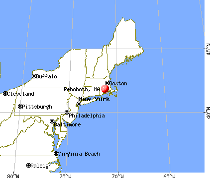
Rehoboth, Massachusetts
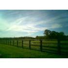
Submit your own pictures of this town and show them to the world
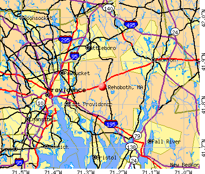
- OSM Map
- General Map
- Google Map
- MSN Map
Population change since 2000: +14.1%
 |
| Males: 5,805 | |
| Females: 5,803 |
| Median resident age: | 43.5 years |
| Massachusetts median age: | 39.2 years |
Zip codes: 02769.
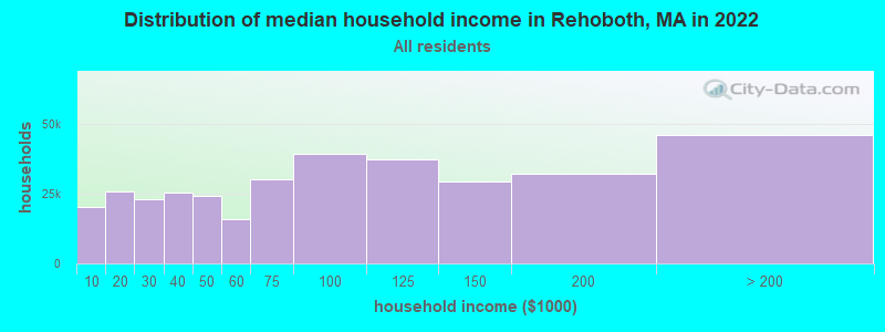
| Rehoboth: | $122,568 |
| MA: | $94,488 |
Estimated per capita income in 2022: $53,969 (it was $26,467 in 2000)
Rehoboth town income, earnings, and wages data
Estimated median house or condo value in 2022: $587,356 (it was $200,000 in 2000)
| Rehoboth: | $587,356 |
| MA: | $534,700 |
Mean prices in 2022: all housing units: $449,660; detached houses: $484,124; townhouses or other attached units: $382,766; in 2-unit structures: $322,469; in 3-to-4-unit structures: $355,875; in 5-or-more-unit structures: $269,714; mobile homes: $156,871; occupied boats, rvs, vans, etc.: $49,834
Detailed information about poverty and poor residents in Rehoboth, MA


Compare current foreclosures near Rehoboth, MA:
| Photo | Address | Area | Beds / Baths | Price | Details |
|---|---|---|---|---|---|

|
#1
Quint Rd
Rehoboth, MA 02769
|
1,762 sq. feet
|
1 baths 3 beds |
show details | |

|
#2
Bay State Rd
Rehoboth, MA 02769
|
3,809 sq. feet
|
4 baths 5 beds |
show details | |

|
#3
Wheeler St
Rehoboth, MA 02769
|
1,824 sq. feet
|
1 baths 3 beds |
show details | |

|
#4
Old Barney Ave
Rehoboth, MA 02769
|
1,132 sq. feet
|
1 baths 3 beds |
show details | |

|
#5
Broad St
Rehoboth, MA 02769
|
2,352 sq. feet
|
2 baths 4 beds |
show details | |

|
#6
Peck St
Rehoboth, MA 02769
|
1,296 sq. feet
|
1 baths 3 beds |
show details | |

|
#7
County St
Rehoboth, MA 02769
|
1,692 sq. feet
|
2 baths 2 beds |
show details | |

|
#8
Danforth St
Rehoboth, MA 02769
|
- sq. feet
|
- baths - beds |
show details | |

|
#9
Somerset Ave
Taunton, MA 02780
|
3,196 sq. feet
|
3 baths 4 beds |
$754,900
|
show details |

|
#10
Hebron Ave
Attleboro, MA 02703
|
2,939 sq. feet
|
4 baths 6 beds |
$559,900
|
show details |
| Photo | Address | Area | Beds / Baths | Price | Details |
|---|---|---|---|---|---|

|
#11
Loomis St
North Attleboro, MA 02760
|
2,294 sq. feet
|
2 baths 4 beds |
$700,000
|
show details |

|
#12
Cook Rd
Cumberland, RI 02864
|
2,050 sq. feet
|
2 baths 4 beds |
$749,500
|
show details |

|
#13
Horton St
North Dighton, MA 02764
|
816 sq. feet
|
1 baths 2 beds |
$259,900
|
show details |

|
#14
Whittier Ave
Providence, RI 02909
|
3 sq. feet
|
3 baths 6 beds |
$109,900
|
show details |

|
#15
County St
East Taunton, MA 02718
|
1,157 sq. feet
|
1 baths 1 beds |
$219,900
|
show details |

|
#16
Albion St
Fall River, MA 02723
|
2,481 sq. feet
|
3 baths 6 beds |
show details | |

|
#17
Valley Green Court
Providence, RI 02904
|
1,440 sq. feet
|
3 baths 2 beds |
show details | |

|
#18
What Cheer Ave
Providence, RI 02909
|
2,280 sq. feet
|
2 baths 3 beds |
show details | |

|
#19
Mount Hope St
North Attleboro, MA 02760
|
3,554 sq. feet
|
2 baths 4 beds |
show details | |

|
#20
Woburn St
Cranston, RI 02910
|
1,212 sq. feet
|
1 baths 4 beds |
show details |
| Photo | Address | Area | Beds / Baths | Price | Details |
|---|---|---|---|---|---|

|
#21
Depot St
North Attleboro, MA 02760
|
- sq. feet
|
2 baths 3 beds |
show details | |

|
#22
Maxwell St
Taunton, MA 02780
|
1,537 sq. feet
|
2 baths 5 beds |
show details | |

|
#23
Lisa Ln
Bristol, RI 02809
|
1,658 sq. feet
|
2 baths 3 beds |
show details | |

|
#24
Marion Avenue
Providence, RI 02905
|
1,252 sq. feet
|
1 baths 3 beds |
show details | |

|
#25
Tyndall Ave
Providence, RI 02908
|
1,523 sq. feet
|
1 baths 4 beds |
show details | |

|
#26
Chace Ave
Warren, RI 02885
|
1,224 sq. feet
|
1 baths 2 beds |
show details | |

|
#27
Bracken St
Cranston, RI 02920
|
1,248 sq. feet
|
1 baths 4 beds |
show details | |

|
#28
Branch Ave
Providence, RI 02904
|
2,921 sq. feet
|
4 baths 6 beds |
show details | |

|
#29
Claremont Avenue A/k/a 5 Claremont Avenue
Bristol, RI 02809
|
1,852 sq. feet
|
2 baths 2 beds |
show details | |

|
#30
Pokross St
Fall River, MA 02724
|
960 sq. feet
|
1 baths 3 beds |
show details |
| Photo | Address | Area | Beds / Baths | Price | Details |
|---|---|---|---|---|---|

|
#31
Pridemark Ln
Attleboro, MA 02703
|
1,340 sq. feet
|
1 baths 2 beds |
show details | |

|
#32
Hancock St
Tiverton, RI 02878
|
1,628 sq. feet
|
2 baths 3 beds |
show details | |

|
#33
S Elm St
West Bridgewater, MA 02379
|
2,546 sq. feet
|
2 baths 4 beds |
show details | |

|
#34
Guertin St
West Warwick, RI 02893
|
1,338 sq. feet
|
2 baths 4 beds |
show details | |

|
#35
Braley Rd
East Freetown, MA 02717
|
819 sq. feet
|
1 baths 2 beds |
show details | |

|
#36
Putnam Pike
Greenville, RI 02828
|
1,114 sq. feet
|
1 baths 2 beds |
show details | |

|
#37
Ivy Ln
Lakeville, MA 02347
|
496 sq. feet
|
1 baths 1 beds |
show details | |

|
#38
Mill St
Foxboro, MA 02035
|
1,584 sq. feet
|
2 baths 3 beds |
show details | |

|
#39
Spooner Ave
Warwick, RI 02886
|
1,777 sq. feet
|
2 baths 4 beds |
show details | |

|
#40
Verndale St
Warwick, RI 02889
|
1,206 sq. feet
|
1 baths 2 beds |
show details |
| Photo | Address | Area | Beds / Baths | Price | Details |
|---|---|---|---|---|---|

|
#41
Hazard Ave
Warwick, RI 02889
|
1,017 sq. feet
|
1 baths 3 beds |
show details | |

|
#42
Pinnery Ave
Warwick, RI 02886
|
1,299 sq. feet
|
1 baths 3 beds |
show details | |

|
#43
Atwood Ave
Johnston, RI 02919
|
1,792 sq. feet
|
1 baths 4 beds |
show details | |

|
#44
Atwood Ave
Johnston, RI 02919
|
1,792 sq. feet
|
2 baths 4 beds |
show details | |

|
#45
Follett St
East Providence, RI 02914
|
1,584 sq. feet
|
2 baths 4 beds |
show details | |

|
#46
Wingold St
Fall River, MA 02720
|
1,028 sq. feet
|
1 baths 2 beds |
show details | |

|
#47
Cynthia Dr Apt 13
North Providence, RI 02911
|
768 sq. feet
|
1 baths 2 beds |
show details | |

|
#48
Thacher St
Attleboro, MA 02703
|
1,040 sq. feet
|
1 baths 3 beds |
show details | |

|
#49
Van Zandt Ave
Warwick, RI 02889
|
800 sq. feet
|
1 baths 4 beds |
show details | |

|
Check over 1 million property listings on Foreclosure.com!
|
browse all offers | |||

- 11,08495.5%White alone
- 1831.6%Hispanic
- 1151.0%Asian alone
- 1181.0%Two or more races
- 560.5%Black alone
- 220.2%American Indian alone
- 260.2%Other race alone
- 40.03%Native Hawaiian and Other
Pacific Islander alone
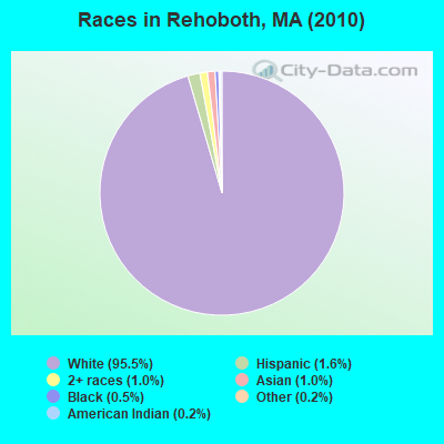
Races in Rehoboth detailed stats: ancestries, foreign born residents, place of birth
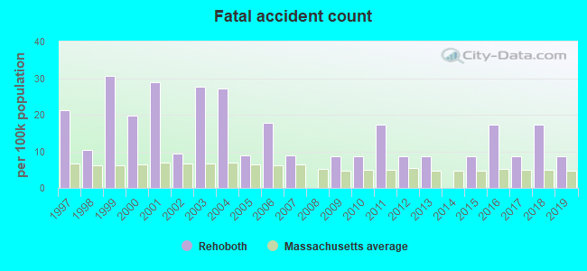
According to our research of Massachusetts and other state lists, there were 11 registered sex offenders living in Rehoboth, Massachusetts as of April 28, 2024.
The ratio of all residents to sex offenders in Rehoboth is 1,055 to 1.
Type |
2009 |
2010 |
2011 |
2012 |
2013 |
2014 |
2015 |
2016 |
2017 |
2018 |
2019 |
2020 |
2021 |
2022 |
|---|---|---|---|---|---|---|---|---|---|---|---|---|---|---|
| Murders (per 100,000) | 0 (0.0) | 2 (17.2) | 0 (0.0) | 0 (0.0) | 0 (0.0) | 0 (0.0) | 0 (0.0) | 0 (0.0) | 0 (0.0) | 0 (0.0) | 0 (0.0) | 0 (0.0) | 0 (0.0) | 0 (0.0) |
| Rapes (per 100,000) | 0 (0.0) | 2 (17.2) | 2 (17.1) | 1 (8.5) | 1 (8.5) | 2 (16.8) | 2 (16.7) | 2 (16.6) | 1 (8.2) | 0 (0.0) | 0 (0.0) | 4 (32.2) | 1 (7.9) | 3 (23.2) |
| Robberies (per 100,000) | 3 (25.4) | 0 (0.0) | 0 (0.0) | 0 (0.0) | 1 (8.5) | 0 (0.0) | 0 (0.0) | 1 (8.3) | 0 (0.0) | 0 (0.0) | 1 (8.2) | 0 (0.0) | 1 (7.9) | 0 (0.0) |
| Assaults (per 100,000) | 25 (212.0) | 10 (86.1) | 9 (77.1) | 13 (110.9) | 11 (93.1) | 7 (58.7) | 13 (108.3) | 14 (116.3) | 9 (74.1) | 8 (65.2) | 7 (57.1) | 5 (40.3) | 11 (86.6) | 11 (85.0) |
| Burglaries (per 100,000) | 75 (635.9) | 57 (491.0) | 46 (393.9) | 46 (392.4) | 51 (431.9) | 24 (201.3) | 28 (233.2) | 35 (290.9) | 15 (123.4) | 14 (114.1) | 16 (130.6) | 9 (72.5) | 11 (86.6) | 7 (54.1) |
| Thefts (per 100,000) | 85 (720.6) | 88 (758.1) | 103 (881.9) | 130 (1,109) | 83 (702.9) | 76 (637.4) | 81 (674.7) | 65 (540.2) | 41 (337.4) | 77 (627.6) | 26 (212.2) | 35 (282.1) | 28 (220.5) | 40 (309.2) |
| Auto thefts (per 100,000) | 12 (101.7) | 14 (120.6) | 7 (59.9) | 6 (51.2) | 9 (76.2) | 6 (50.3) | 7 (58.3) | 4 (33.2) | 7 (57.6) | 8 (65.2) | 4 (32.6) | 9 (72.5) | 5 (39.4) | 4 (30.9) |
| Arson (per 100,000) | 2 (17.0) | 4 (34.5) | 0 (0.0) | 1 (8.5) | 0 (0.0) | 0 (0.0) | 1 (8.3) | 1 (8.3) | 1 (8.2) | 0 (0.0) | 0 (0.0) | 0 (0.0) | 0 (0.0) | 0 (0.0) |
| City-Data.com crime index | 131.5 | 139.8 | 96.8 | 104.9 | 92.4 | 68.8 | 83.0 | 83.7 | 48.1 | 51.4 | 34.1 | 56.0 | 44.0 | 54.2 |
The City-Data.com crime index weighs serious crimes and violent crimes more heavily. Higher means more crime, U.S. average is 246.1. It adjusts for the number of visitors and daily workers commuting into cities.
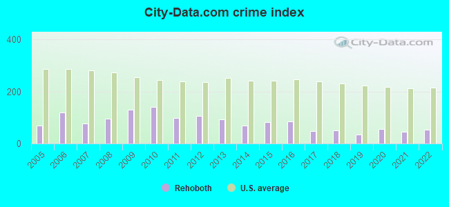
Crime rate in Rehoboth detailed stats: murders, rapes, robberies, assaults, burglaries, thefts, arson
Full-time law enforcement employees in 2021, including police officers: 35 (29 officers - 28 male; 1 female).
| Officers per 1,000 residents here: | 2.28 |
| Massachusetts average: | 2.53 |
 Recent articles from our blog. Our writers, many of them Ph.D. graduates or candidates, create easy-to-read articles on a wide variety of topics.

 | Trans male knocks out teens teeth in swampScott. (44 replies) |
| Coronavirus in Massachusetts (18047 replies) |
| Best coastal town in Mass for young retirees (106 replies) |
| Police expecting a rough summer ahead, in the city. (2481 replies) |
| Moving to Massachusetts (75 replies) |
| Towns in Boston MSA, but many might think not (44 replies) |
Latest news from Rehoboth, MA collected exclusively by city-data.com from local newspapers, TV, and radio stations
Ancestries: Irish (22.5%), English (22.2%), Portuguese (21.7%), French (14.2%), Italian (11.8%), French Canadian (8.4%).
Current Local Time: EST time zone
Incorporated in 1645
Elevation: 50 feet
Land area: 46.5 square miles.
Population density: 250 people per square mile (very low).
462 residents are foreign born (3.4% Europe, 0.7% Asia).
| This town: | 4.5% |
| Massachusetts: | 12.2% |
| Rehoboth town: | 1.1% ($2,275) |
| Massachusetts: | 1.3% ($2,336) |
Nearest city with pop. 50,000+: Pawtucket, RI  (6.5 miles , pop. 72,958).
Nearest city with pop. 200,000+: Boston, MA (34.8 miles , pop. 589,141).
Nearest city with pop. 1,000,000+: Bronx, NY (151.9 miles , pop. 1,332,650).
Nearest cities:
), ), Latitude: 41.84 N, Longitude: 71.26 W
Area codes: 508, 774

Rehoboth, Massachusetts accommodation & food services, waste management - Economy and Business Data
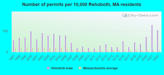
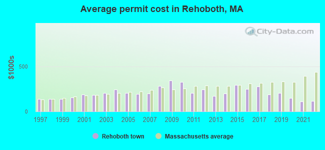
Single-family new house construction building permits:
- 2022: 108 buildings, average cost: $115,600
- 2021: 131 buildings, average cost: $108,000
- 2020: 75 buildings, average cost: $149,100
- 2019: 41 buildings, average cost: $207,200
- 2018: 48 buildings, average cost: $190,000
- 2017: 25 buildings, average cost: $275,700
- 2016: 53 buildings, average cost: $248,500
- 2015: 25 buildings, average cost: $294,300
- 2014: 25 buildings, average cost: $201,100
- 2013: 40 buildings, average cost: $172,700
- 2012: 33 buildings, average cost: $242,400
- 2011: 19 buildings, average cost: $204,100
- 2010: 21 buildings, average cost: $329,400
- 2009: 28 buildings, average cost: $343,900
- 2008: 21 buildings, average cost: $284,000
- 2007: 46 buildings, average cost: $201,000
- 2006: 81 buildings, average cost: $191,600
- 2005: 82 buildings, average cost: $203,800
- 2004: 90 buildings, average cost: $243,600
- 2003: 81 buildings, average cost: $202,700
- 2002: 93 buildings, average cost: $182,800
- 2001: 63 buildings, average cost: $190,200
- 2000: 102 buildings, average cost: $153,700
- 1999: 71 buildings, average cost: $136,100
- 1998: 70 buildings, average cost: $135,500
- 1997: 58 buildings, average cost: $137,900
| Here: | 3.0% |
| Massachusetts: | 3.5% |
- Health care (11.3%)
- Educational services (10.2%)
- Construction (8.8%)
- Finance & insurance (5.6%)
- Professional, scientific, technical services (5.4%)
- Computer & electronic products (4.0%)
- Accommodation & food services (3.8%)
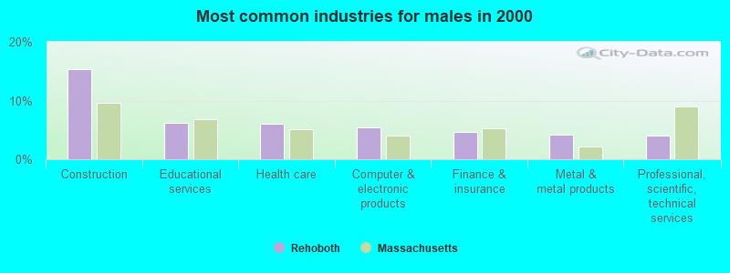
- Construction (15.4%)
- Educational services (6.1%)
- Health care (6.0%)
- Computer & electronic products (5.4%)
- Finance & insurance (4.7%)
- Metal & metal products (4.3%)
- Professional, scientific, technical services (4.1%)
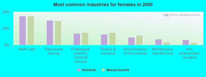
- Health care (17.5%)
- Educational services (14.9%)
- Professional, scientific, technical services (6.9%)
- Finance & insurance (6.6%)
- Accommodation & food services (4.7%)
- Miscellaneous manufacturing (3.6%)
- Arts, entertainment, recreation (3.1%)
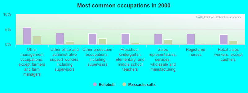
- Other management occupations, except farmers and farm managers (5.6%)
- Other office and administrative support workers, including supervisors (3.8%)
- Other production occupations, including supervisors (3.6%)
- Preschool, kindergarten, elementary, and middle school teachers (3.6%)
- Sales representatives, services, wholesale and manufacturing (3.5%)
- Registered nurses (3.5%)
- Retail sales workers, except cashiers (3.3%)
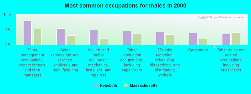
- Other management occupations, except farmers and farm managers (7.8%)
- Sales representatives, services, wholesale and manufacturing (5.3%)
- Vehicle and mobile equipment mechanics, installers, and repairers (5.0%)
- Other production occupations, including supervisors (4.6%)
- Material recording, scheduling, dispatching, and distributing workers (4.3%)
- Carpenters (3.9%)
- Other sales and related occupations, including supervisors (3.6%)
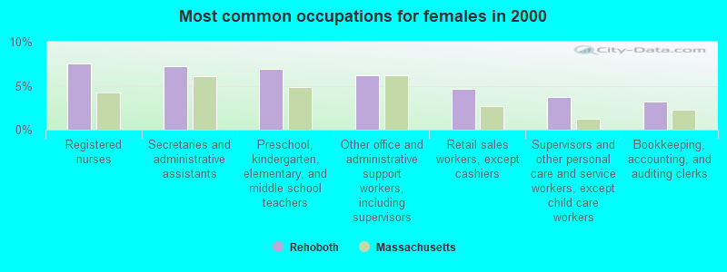
- Registered nurses (7.5%)
- Secretaries and administrative assistants (7.2%)
- Preschool, kindergarten, elementary, and middle school teachers (6.9%)
- Other office and administrative support workers, including supervisors (6.1%)
- Retail sales workers, except cashiers (4.6%)
- Supervisors and other personal care and service workers, except child care workers (3.7%)
- Bookkeeping, accounting, and auditing clerks (3.2%)
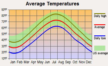
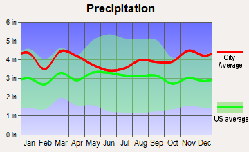
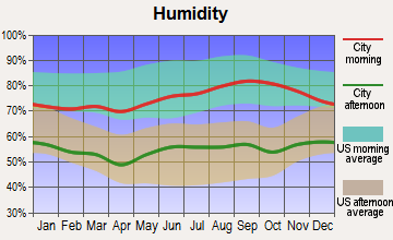
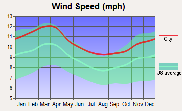
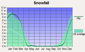
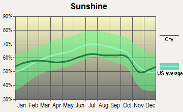
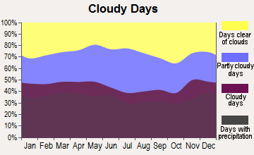
Average climate in Rehoboth, Massachusetts
Based on data reported by over 4,000 weather stations
(lower is better)
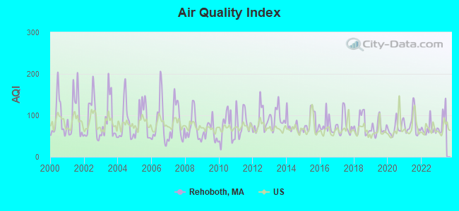
Air Quality Index (AQI) level in 2022 was 66.8. This is about average.
| City: | 66.8 |
| U.S.: | 72.6 |
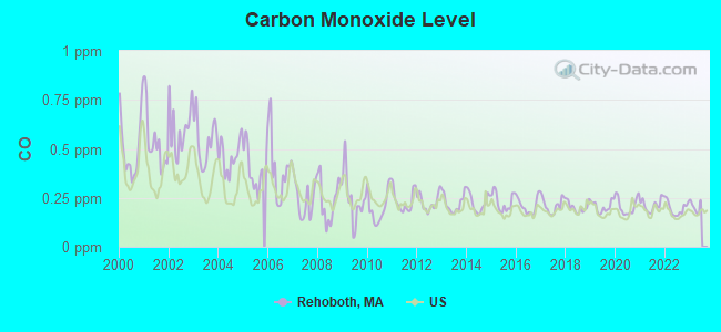
Carbon Monoxide (CO) [ppm] level in 2022 was 0.196. This is better than average. Closest monitor was 5.2 miles away from the city center.
| City: | 0.196 |
| U.S.: | 0.251 |
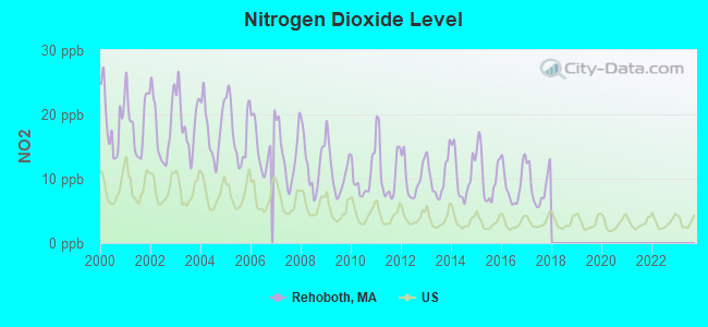
Nitrogen Dioxide (NO2) [ppb] level in 2017 was 8.78. This is significantly worse than average. Closest monitor was 4.8 miles away from the city center.
| City: | 8.78 |
| U.S.: | 5.11 |
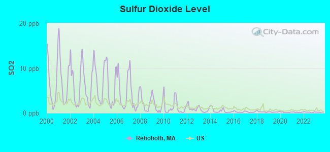
Sulfur Dioxide (SO2) [ppb] level in 2022 was 0.179. This is significantly better than average. Closest monitor was 4.8 miles away from the city center.
| City: | 0.179 |
| U.S.: | 1.515 |
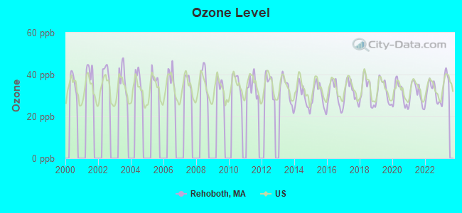
Ozone [ppb] level in 2022 was 31.5. This is about average. Closest monitor was 6.4 miles away from the city center.
| City: | 31.5 |
| U.S.: | 33.3 |
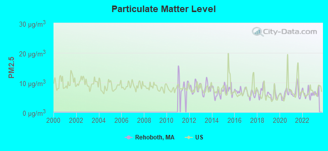
Particulate Matter (PM2.5) [µg/m3] level in 2022 was 6.23. This is better than average. Closest monitor was 5.2 miles away from the city center.
| City: | 6.23 |
| U.S.: | 8.11 |
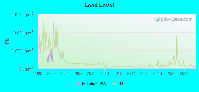
Lead (Pb) [µg/m3] level in 2001 was 0.0146. This is significantly worse than average. Closest monitor was 5.2 miles away from the city center.
| City: | 0.0146 |
| U.S.: | 0.0093 |
Tornado activity:
Rehoboth-area historical tornado activity is slightly below Massachusetts state average. It is 53% smaller than the overall U.S. average.
On 6/9/1953, a category F4 (max. wind speeds 207-260 mph) tornado 34.8 miles away from the Rehoboth town center killed 90 people and injured 1228 people and caused between $50,000,000 and $500,000,000 in damages.
On 6/9/1953, a category F3 (max. wind speeds 158-206 mph) tornado 15.2 miles away from the town center injured 17 people and caused between $500,000 and $5,000,000 in damages.
Earthquake activity:
Rehoboth-area historical earthquake activity is significantly above Massachusetts state average. It is 74% smaller than the overall U.S. average.On 10/7/1983 at 10:18:46, a magnitude 5.3 (5.1 MB, 5.3 LG, 5.1 ML, Class: Moderate, Intensity: VI - VII) earthquake occurred 214.1 miles away from the city center
On 4/20/2002 at 10:50:47, a magnitude 5.3 (5.3 ML, Depth: 3.0 mi) earthquake occurred 222.2 miles away from the city center
On 1/19/1982 at 00:14:42, a magnitude 4.7 (4.5 MB, 4.7 MD, 4.5 LG, Class: Light, Intensity: IV - V) earthquake occurred 116.4 miles away from the city center
On 4/20/2002 at 10:50:47, a magnitude 5.2 (5.2 MB, 4.2 MS, 5.2 MW, 5.0 MW) earthquake occurred 221.4 miles away from the city center
On 10/16/2012 at 23:12:25, a magnitude 4.7 (4.7 ML, Depth: 10.0 mi) earthquake occurred 125.7 miles away from Rehoboth center
On 8/22/1992 at 12:20:32, a magnitude 4.8 (4.8 MB, 3.8 MS, 4.7 LG, Depth: 6.2 mi) earthquake occurred 195.2 miles away from the city center
Magnitude types: regional Lg-wave magnitude (LG), body-wave magnitude (MB), duration magnitude (MD), local magnitude (ML), surface-wave magnitude (MS), moment magnitude (MW)
Natural disasters:
The number of natural disasters in Bristol County (23) is greater than the US average (15).Major Disasters (Presidential) Declared: 12
Emergencies Declared: 11
Causes of natural disasters: Floods: 8, Hurricanes: 7, Storms: 5, Snows: 3, Snowstorms: 3, Winter Storms: 3, Blizzards: 2, Explosion: 1, Heavy Rain: 1, Snowfall: 1, Tropical Storm: 1, Wind: 1 (Note: some incidents may be assigned to more than one category).

Hospitals and medical centers near Rehoboth:
- CULTURED CARE, INC (Home Health Center, about 5 miles away; SWANSEA, MA)
- EVERGREEN HOUSE HEALTH CENTER (Nursing Home, about 5 miles away; EAST PROVIDENCE, RI)
- BEACON HOSPICE (Hospital, about 5 miles away; EAST PROVIDENCE, RI)
- PAWTUCKET SKILLED NURSING AND REHABILITATION (Nursing Home, about 6 miles away; PAWTUCKET, RI)
- OPTION CARE (Home Health Center, about 6 miles away; EAST PROVIDENCE, RI)
- EAST SIDE MANOR (Nursing Home, about 6 miles away; EAST PROVIDENCE, RI)
- EDMUND PLACE HEALTH CENTER (Nursing Home, about 6 miles away; EAST PROVIDENCE, RI)
Heliports located in Rehoboth:
Amtrak station near Rehoboth:
Colleges/universities with over 2000 students nearest to Rehoboth:
- Brown University (about 8 miles; Providence, RI; Full-time enrollment: 8,458)
- Rhode Island School of Design (about 8 miles; Providence, RI; FT enrollment: 2,714)
- Johnson & Wales University-Providence (about 8 miles; Providence, RI; FT enrollment: 10,898)
- Providence College (about 10 miles; Providence, RI; FT enrollment: 4,312)
- Rhode Island College (about 11 miles; Providence, RI; FT enrollment: 7,189)
- Bristol Community College (about 11 miles; Fall River, MA; FT enrollment: 5,707)
- Roger Williams University (about 13 miles; Bristol, RI; FT enrollment: 4,375)
Public elementary/middle schools in Rehoboth:
- PALMER RIVER (Students: 753, Location: 326 WINTHROP STREET, Grades: KG-4)
- DOROTHY L BECKWITH (Students: 619, Location: 330R WINTHROP STREET, Grades: 5-8)
Private elementary/middle school in Rehoboth:
Points of interest:
Notable locations in Rehoboth: Attleboro Rod and Gun Club (A), Bettencourt Farms (B), Sun Valley Golf Club (C), Crestwood Country Club (D), YMCA Camp (E), Rehoboth Country Club (F), Rehoboth Fire Department Station 2 (G), Rehoboth Fire Department Station 3 (H), Rehoboth Fire Department Station 1 Headquarters (I). Display/hide their locations on the map
Churches in Rehoboth include: Bethel Mission Church (A), Hornbine Church (B). Display/hide their locations on the map
Cemeteries: Stevens Corner Cemetery (1), Oak Knoll Cemetery (2), Coldbrook Cemetery (3), Bosworth Cemetery (4), Hix Cemetery (5), Palmer River Cemetery (6). Display/hide their locations on the map
Lakes, reservoirs, and swamps: Perryville Pond (A), Sabin Pond (B), Shad Factory Pond (C), Warren Upper Reservoir (D), Bad Luck Swamp (E), Oak Swamp (F), Manwhague Swamp (G), Squannakonk Swamp (H). Display/hide their locations on the map
Streams, rivers, and creeks: West Branch Palmer River (A), East Branch Palmer River (B), Oak Swamp Brook (C), Carpenter Brook (D), Bliss Brook (E), Wolf Plain Brook (F), Torrey Creek (G), Rocky Run (H), Clear Run Brook (I). Display/hide their locations on the map
Tourist attraction: Carpenter Museum (4 Locust Avenue) (1). Display/hide its approximate location on the map
Birthplace of: John W. Davis (governor) - Politician, Benjamin West (astronomer) - Astronomer, Phanuel Bishop - Politician.
Drinking water stations with addresses in Rehoboth and their reported violations in the past:
HORTON ESTATES CONDOMINIUM TRUST, INC. (Address: 15 SAMANTHA LANE , Population served: 64, Groundwater):Past monitoring violations:WINTHROP VILLAGE PLAZA (Address: 183 WINTHROP STREET , Population served: 50, Groundwater):
- Notification, State - In JUL-2012, Contaminant: Coliform (TCR). Follow-up actions: St AO (w/o penalty) issued (NOV-30-2012), St Compliance achieved (JAN-16-2013)
Past health violations:Past monitoring violations:
- MCL, Monthly (TCR) - In MAY-2013, Contaminant: Coliform. Follow-up actions: St AO (w/o penalty) issued (AUG-30-2013), St Compliance achieved (AUG-30-2013)
- Notification, State - In JUN-2013, Contaminant: Coliform (TCR). Follow-up actions: St AO (w/o penalty) issued (AUG-30-2013), St Compliance achieved (AUG-30-2013)
- 3 routine major monitoring violations
- One regular monitoring violation
| This town: | 2.8 people |
| Massachusetts: | 2.5 people |
| This town: | 80.0% |
| Whole state: | 63.0% |
| This town: | 6.1% |
| Whole state: | 7.0% |
Likely homosexual households (counted as self-reported same-sex unmarried-partner households)
- Lesbian couples: 0.5% of all households
- Gay men: 0.5% of all households
| This town: | 3.1% |
| Whole state: | 9.3% |
| This town: | 1.2% |
| Whole state: | 4.4% |
Banks with branches in Rehoboth (2011 data):
- Bristol County Savings Bank: Rehoboth Branch at 257 Winthrop Street, branch established on 1981/04/27. Info updated 2007/09/11: Bank assets: $1,338.8 mil, Deposits: $1,027.4 mil, headquarters in Taunton, MA, positive income, Commercial Lending Specialization, 13 total offices, Holding Company: Beacon Bancorp
For population 15 years and over in Rehoboth:
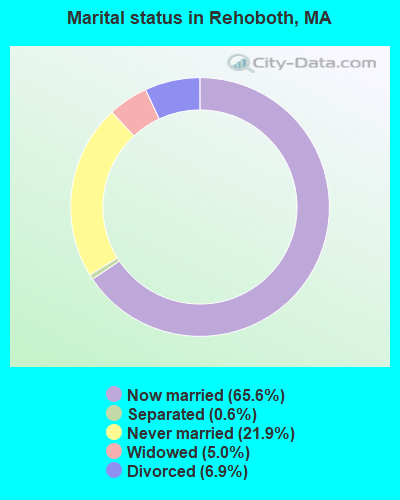
- Never married: 21.9%
- Now married: 65.6%
- Separated: 0.6%
- Widowed: 5.0%
- Divorced: 6.9%
For population 25 years and over in Rehoboth:
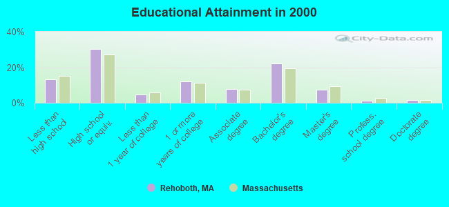
- High school or higher: 86.8%
- Bachelor's degree or higher: 32.1%
- Graduate or professional degree: 10.1%
- Unemployed: 3.3%
- Mean travel time to work (commute): 26.6 minutes
| Here: | 11.5 |
| Massachusetts average: | 13.1 |
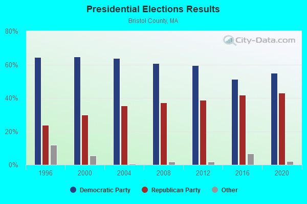
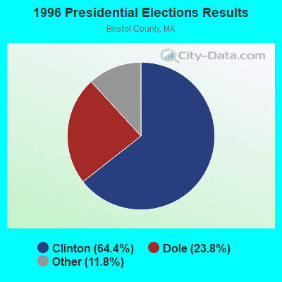
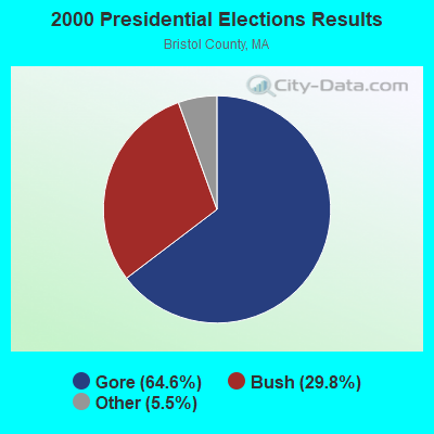
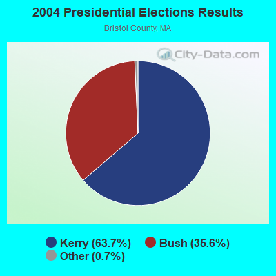
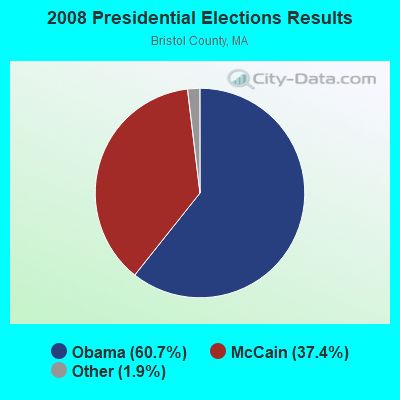
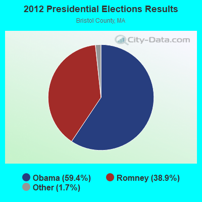

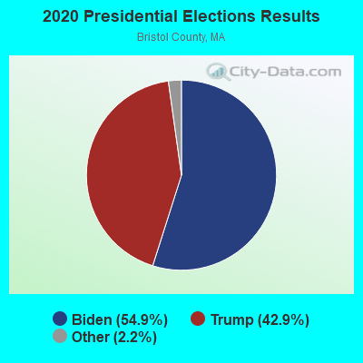
Graphs represent county-level data. Detailed 2008 Election Results
Religion statistics for Rehoboth, MA (based on Bristol County data)
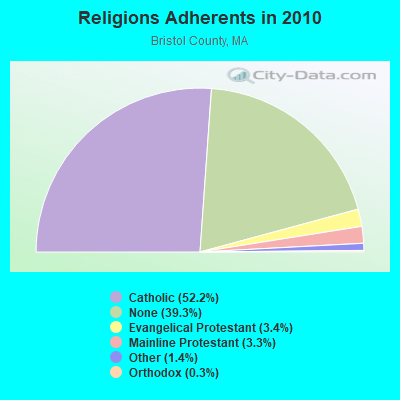
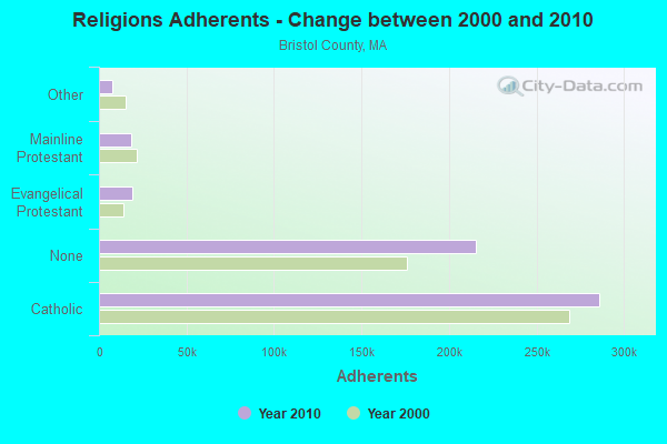
| Religion | Adherents | Congregations |
|---|---|---|
| Catholic | 286,113 | 72 |
| Evangelical Protestant | 18,765 | 128 |
| Mainline Protestant | 18,246 | 83 |
| Other | 7,807 | 33 |
| Orthodox | 1,565 | 4 |
| Black Protestant | 511 | 5 |
| None | 215,278 | - |
Food Environment Statistics:
| This county: | 2.00 / 10,000 pop. |
| Massachusetts: | 1.98 / 10,000 pop. |
| Bristol County: | 0.09 / 10,000 pop. |
| State: | 0.05 / 10,000 pop. |
| Bristol County: | 1.93 / 10,000 pop. |
| Massachusetts: | 2.22 / 10,000 pop. |
| Bristol County: | 2.35 / 10,000 pop. |
| State: | 1.77 / 10,000 pop. |
| Bristol County: | 8.20 / 10,000 pop. |
| Massachusetts: | 8.76 / 10,000 pop. |
| Here: | 9.5% |
| Massachusetts: | 8.1% |
| This county: | 26.9% |
| Massachusetts: | 22.5% |
| This county: | 14.4% |
| Massachusetts: | 16.5% |
4.76% of this county's 2021 resident taxpayers lived in other counties in 2020 ($70,162 average adjusted gross income)
| Here: | 4.76% |
| Massachusetts average: | 6.35% |
0.01% of residents moved from foreign countries ($64 average AGI)
Bristol County: 0.01% Massachusetts average: 0.01%
Top counties from which taxpayers relocated into this county between 2020 and 2021:
| from Plymouth County, MA | |
| from Norfolk County, MA | |
| from Providence County, RI |
4.63% of this county's 2020 resident taxpayers moved to other counties in 2021 ($72,404 average adjusted gross income)
| Here: | 4.63% |
| Massachusetts average: | 7.18% |
0.01% of residents moved to foreign countries ($83 average AGI)
Bristol County: 0.01% Massachusetts average: 0.02%
Top counties to which taxpayers relocated from this county between 2020 and 2021:
| to Plymouth County, MA | |
| to Providence County, RI | |
| to Norfolk County, MA |
Businesses in Rehoboth, MA
- Dunkin Donuts: 1
- FedEx: 1
- U-Haul: 1
Strongest AM radio stations in Rehoboth:
- WPRO (630 AM; 5 kW; PROVIDENCE, RI; Owner: CITADEL BROADCASTING COMPANY)
- WSKO (790 AM; 5 kW; PROVIDENCE, RI; Owner: CITADEL BROADCASTING COMPANY)
- WHJJ (920 AM; 5 kW; PROVIDENCE, RI)
- WPMZ (1110 AM; daytime; 5 kW; EAST PROVIDENCE, RI; Owner: VIDEO MUNDO B/CASTING CO., LLC)
- WALE (990 AM; 50 kW; GREENVILLE, RI; Owner: NORTH AMERICAN BROADCASTING CO., INC.)
- WDDZ (550 AM; 5 kW; PAWTUCKET, RI; Owner: ABC, INC.)
- WRNI (1290 AM; 10 kW; PROVIDENCE, RI; Owner: WRNI FOUNDATION)
- WEEI (850 AM; 50 kW; BOSTON, MA; Owner: ENTERCOM BOSTON LICENSE, LLC)
- WSAR (1480 AM; 5 kW; FALL RIVER, MA; Owner: BRISTOL COUNTY BROADCASTING, INC.)
- WARL (1320 AM; 5 kW; ATTLEBORO, MA; Owner: THE ADD RADIO GROUP, INC.)
- WKOX (1200 AM; 50 kW; FRAMINGHAM, MA; Owner: CAPSTAR TX LIMITED PARTNERSHIP)
- WBZ (1030 AM; 50 kW; BOSTON, MA; Owner: INFINITY BROADCASTING OPERATIONS, INC.)
- WBIX (1060 AM; 40 kW; NATICK, MA; Owner: LANGER BROADCASTING CORPORATION)
Strongest FM radio stations in Rehoboth:
- WWBB (101.5 FM; PROVIDENCE, RI; Owner: CLEAR CHANNEL BROADCASTING LICENSES, INC.)
- WSNE-FM (93.3 FM; TAUNTON, MA; Owner: CAPSTAR TX LIMITED PARTNERSHIP)
- WBRU (95.5 FM; PROVIDENCE, RI; Owner: BROWN BROADCASTING SERVICE, INC.)
- WHJY (94.1 FM; PROVIDENCE, RI; Owner: CAPSTAR TX LIMITED PARTNERSHIP)
- WPRO-FM (92.3 FM; PROVIDENCE, RI; Owner: CITADEL BROADCASTING COMPANY)
- WWLI (105.1 FM; PROVIDENCE, RI; Owner: CITADEL BROADCASTING COMPANY)
- WELH (88.1 FM; PROVIDENCE, RI; Owner: THE WHEELER SCHOOL)
- WKKB (100.3 FM; MIDDLETOWN, RI; Owner: CITADEL BROADCASTING COMPANY)
- WWKX (106.3 FM; WOONSOCKET, RI; Owner: AAA ENTERTAINMENT LICENSING LLC)
- WBMX (98.5 FM; BOSTON, MA; Owner: INFINITY RADIO OPERATIONS INC.)
- WBOS (92.9 FM; BROOKLINE, MA; Owner: GREATER BOSTON RADIO, INC.)
- WJMN (94.5 FM; BOSTON, MA; Owner: AMFM RADIO LICENSES, L.L.C.)
- WCRB (102.5 FM; WALTHAM, MA; Owner: CHARLES RIVER BROADCASTING WCRB LICE)
- WTKK (96.9 FM; BOSTON, MA; Owner: GREATER BOSTON RADIO, INC.)
- WROR-FM (105.7 FM; FRAMINGHAM, MA; Owner: GREATER BOSTON RADIO, INC.)
- WBOT (97.7 FM; BROCKTON, MA; Owner: RADIO ONE LICENSES, LLC)
- WGBH (89.7 FM; BOSTON, MA; Owner: WGBH EDUCATIONAL FOUNDATION)
- WXKS-FM (107.9 FM; MEDFORD, MA; Owner: AMFM RADIO LICENSES, L.L.C.)
- WBUR-FM (90.9 FM; BOSTON, MA; Owner: TRUSTEES OF BOSTON UNIVERSITY)
- WMJX (106.7 FM; BOSTON, MA; Owner: GREATER BOSTON RADIO, INC.)
TV broadcast stations around Rehoboth:
- WLNE-TV (Channel 6; NEW BEDFORD, MA; Owner: FREEDOM BROADCASTING OF SOUTHERN NEW ENGLAND, INC.)
- WJAR (Channel 10; PROVIDENCE, RI; Owner: OUTLET BROADCASTING, INC.)
- WSBE-TV (Channel 36; PROVIDENCE, RI; Owner: RHODE ISLAND PUBLIC TELECOM. AUTHORITY)
- WNAC-TV (Channel 64; PROVIDENCE, RI; Owner: WNAC, LLC)
- WPRI-TV (Channel 12; PROVIDENCE, RI; Owner: TVL BROADCASTING OF RHODE ISLAND, LLC)
- WWDP (Channel 46; NORWELL, MA; Owner: NORWELL TELEVISION, LLC)
- WPXQ (Channel 69; BLOCK ISLAND, RI; Owner: OCEAN STATE TELEVISION, L.L.C.)
- WLWC (Channel 28; NEW BEDFORD, MA; Owner: C-28 FCC LICENSEE SUBSIDIARY, LLC)
- WCVB-TV (Channel 5; BOSTON, MA; Owner: WCVB HEARST-ARGYLE TV, INC.)
- WGBH-TV (Channel 2; BOSTON, MA; Owner: WGBH EDUCATIONAL FOUNDATION)
- WHDH-TV (Channel 7; BOSTON, MA; Owner: WHDH-TV)
- WMFP (Channel 62; LAWRENCE, MA; Owner: WSAH LICENSE, INC.)
- WSBK-TV (Channel 38; BOSTON, MA; Owner: VIACOM INC.)
- WLVI-TV (Channel 56; CAMBRIDGE, MA; Owner: WLVI, INC.)
- WBZ-TV (Channel 4; BOSTON, MA; Owner: VIACOM INC.)
- WGBX-TV (Channel 44; BOSTON, MA; Owner: WGBH EDUCATIONAL FOUNDATION)
- WRIW-LP (Channel 50; PROVIDENCE, RI; Owner: ZGS PROVIDENCE, INC.)
- WFXT (Channel 25; BOSTON, MA; Owner: FOX TELEVISION STATIONS INC.)
- WUNI (Channel 27; WORCESTER, MA; Owner: ENTRAVISION HOLDINGS, LLC)
- WUTF (Channel 66; MARLBOROUGH, MA; Owner: TELEFUTURA BOSTON LLC)
- WBPX (Channel 68; BOSTON, MA; Owner: PAXSON BOSTON-68 LICENSE, INC.)
- W40BO (Channel 40; BOSTON, MA; Owner: PAXSON COMMUNICATIONS LPTV, INC.)
- WTMU-LP (Channel 32; BOSTON, MA; Owner: ZGS BOSTON, INC.)
- WCEA-LP (Channel 58; BOSTON, MA; Owner: CHANNEL 19 TV CORPORATION)
- National Bridge Inventory (NBI) Statistics
- 14Number of bridges
- 112ft / 34.3mTotal length
- $26,956,000Total costs
- 295,999Total average daily traffic
- 6,101Total average daily truck traffic
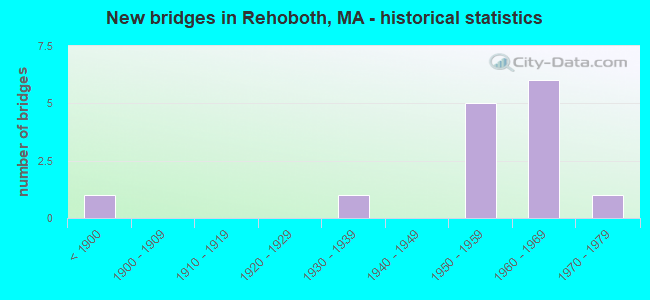
- New bridges - historical statistics
- 1Before 1900
- 11930-1939
- 51950-1959
- 61960-1969
- 11970-1979
FCC Registered Cell Phone Towers:
2 (See the full list of FCC Registered Cell Phone Towers in Rehoboth)FCC Registered Antenna Towers:
42 (See the full list of FCC Registered Antenna Towers)FCC Registered Commercial Land Mobile Towers:
2- Lat: 41.865111 Lon: -71.287000, Structure height: 164 m, Call Sign: KPJ203,
Assigned Frequencies: 450.020 MHz, Grant Date: 11/05/1985, Cancellation Date: 09/30/2008, Registrant: Dow Lohnes Pllc, 1200 New Hampshire Ave, Nw, Suite 800, Washington, DC 20036, Phone: (202) 776-2000, Fax: (202) 776-2222, Email:
- 33 Pine St (Lat: 41.870667 Lon: -71.295333), Call Sign: KPM579,
Assigned Frequencies: 450.990 MHz, Grant Date: 03/10/1994, Expiration Date: 04/01/1998, Cancellation Date: 09/24/2000, Registrant: Wilks Schwartz Broadcasting Of Providence Inc, 1445 Wampanoag Trail, East Providence, RI 02915, Phone: (401) 433-1000
FCC Registered Broadcast Land Mobile Towers:
5- 356 Tremont St (Lat: 41.903444 Lon: -71.262833), Call Sign: WYJ716, Licensee ID: L00321527,
Assigned Frequencies: 35.1000 MHz, Grant Date: 09/18/2013, Expiration Date: 12/08/2023, Cancellation Date: 02/10/2024, Registrant: Glenn L Doucette, 356 Tremont St, Rehoboth, MA 02769, Phone: (508) 222-2592, Fax: (508) 222-2983, Email:
- Longhill 2.5 Mi Ese (Lat: 41.835389 Lon: -71.203111), Type: Pole, Structure height: 27 m, Call Sign: WPMF476,
Assigned Frequencies: 49.0200 MHz, Grant Date: 06/03/2003, Expiration Date: 07/01/2013, Cancellation Date: 04/15/2013, Certifier: Scott Pittman, Registrant: Spectra Energy, 5400 Westheimer Court, Houston, TX 77056-5310, Phone: (713) 627-5229, Fax: (713) 386-4185, Email:
- 195 Homestead Avenue (Lat: 41.876667 Lon: -71.282500), Type: Tower, Structure height: 28.6 m, Overall height: 29.5 m, Call Sign: WPYI299,
Assigned Frequencies: 5350.00 MHz, Grant Date: 08/14/2003, Expiration Date: 02/14/2004, Cancellation Date: 12/10/2003, Certifier: Marcia L Greene, Registrant: Covington & Burling, 1201 Pennsylvania Avenue, N.W., Washington, DC 20004-2401, Phone: (202) 662-5120, Fax: (202) 662-6291, Email:
- 195 Homestead Avenue (Lat: 41.876667 Lon: -71.282500), Type: Tower, Structure height: 28.6 m, Overall height: 29.5 m, Call Sign: WPYW785,
Assigned Frequencies: 5350.00 MHz, Grant Date: 11/18/2003, Expiration Date: 11/18/2013, Cancellation Date: 08/29/2013, Certifier: Marcia L Greene, Registrant: Lin Television Corporation, One West Exchange Street, Suite 5a, Providence, RI 02903, Phone: (401) 454-2880, Fax: (401) 454-2817, Email:
- Lat: 41.824028 Lon: -71.277889, Call Sign: WQBL817,
Assigned Frequencies: 452.187 MHz, 457.187 MHz, Grant Date: 11/02/2004, Expiration Date: 11/02/2014, Cancellation Date: 01/03/2015, Certifier: Frank Aanda, Registrant: Cara Enterprises Inc, Salt Lake City, UT 84117-0503, Phone: (801) 278-9728, Fax: (801) 278-7239
FCC Registered Microwave Towers:
25 (See the full list of FCC Registered Microwave Towers in this town)FCC Registered Paging Towers:
5 (See the full list of FCC Registered Paging Towers)FCC Registered Amateur Radio Licenses:
74 (See the full list of FCC Registered Amateur Radio Licenses in Rehoboth)FAA Registered Aircraft:
6- Aircraft: JOHN M NYS RV10 (Category: Land, Seats: 4, Weight: Up to 12,499 Pounds), Engine: LYCOMING IO-540-EXP (330 HP) (Reciprocating)
N-Number: 10YS, N10YS, N-10YS, Serial Number: 41023, Year manufactured: 2012, Airworthiness Date: 12/18/2012, Certificate Issue Date: 11/05/2020
Registrant (Individual): Michael Lupo, 34 Reynolds Ave, Rehoboth, MA 02769 - Aircraft: AERONCA 65-CA (Category: Land, Seats: 2, Weight: Up to 12,499 Pounds, Speed: 75 mph), Engine: CONT MOTOR A&C65 SERIES (65 HP) (Reciprocating)
N-Number: 34573, N34573, N-34573, Serial Number: CA-15411, Year manufactured: 1941, Airworthiness Date: 12/23/1959, Certificate Issue Date: 01/06/2014
Registrant (Individual): William R Arsenault, 19 Pine St, Rehoboth, MA 02769 - Aircraft: ENSTROM HELICOPTER CORP 480B (Category: Land, Seats: 5, Weight: 12,500 - 19,999 Pounds), Engine: ALLISON 250 SER (420 HP) (Turbo-shaft)
N-Number: 723BF, N723BF, N-723BF, Serial Number: 5047, Year manufactured: 2002, Airworthiness Date: 02/05/2002, Certificate Issue Date: 08/04/2009
Registrant (Corporation): J & J Materials Corp, 71 Fall River Ave, Rehoboth, MA 02769 - Aircraft: CHAMPION 7GCAA (Category: Land, Seats: 2, Weight: Up to 12,499 Pounds, Speed: 90 mph), Engine: LYCOMING 0-320 SERIES (180 HP) (Reciprocating)
N-Number: 7501F, N7501F, N-7501F, Serial Number: 204, Year manufactured: 1969, Airworthiness Date: 09/08/1969, Certificate Issue Date: 01/06/2010
Registrant (Corporation): Stafford Tech Inc, 237 Hornbine Rd, Rehoboth, MA 02769 - Aircraft: CESSNA 140 (Category: Land, Seats: 2, Weight: Up to 12,499 Pounds, Speed: 105 mph), Engine: CONT MOTOR C85 SERIES (85 HP) (Reciprocating)
N-Number: 77330, N77330, N-77330, Serial Number: 11772, Year manufactured: 1946, Airworthiness Date: 05/26/1955, Certificate Issue Date: 08/27/2004
Registrant (Individual): Paul D Proulx, 10 Katherine Rd, Rehoboth, MA 02769 - Aircraft: GREEN BOBBY R RV4 (Category: Land, Seats: 2, Weight: Up to 12,499 Pounds), Engine: LYCOMING 0-320 SERIES (180 HP) (Reciprocating)
N-Number: 929RV, N929RV, N-929RV, Serial Number: 4039, Year manufactured: 2005, Airworthiness Date: 08/22/2005, Certificate Issue Date: 06/30/2015
Registrant (Corporation): Stafford Tech Inc, 237 Hornbine Rd, Rehoboth, MA 02769
2002 - 2018 National Fire Incident Reporting System (NFIRS) incidents
- Fire incident types reported to NFIRS in Rehoboth, MA
- 48250.4%Structure Fires
- 34736.3%Outside Fires
- 10811.3%Mobile Property/Vehicle Fires
- 192.0%Other
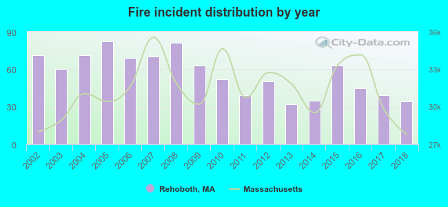 Based on the data from the years 2002 - 2018 the average number of fire incidents per year is 56. The highest number of reported fire incidents - 82 took place in 2005, and the least - 32 in 2013. The data has a dropping trend.
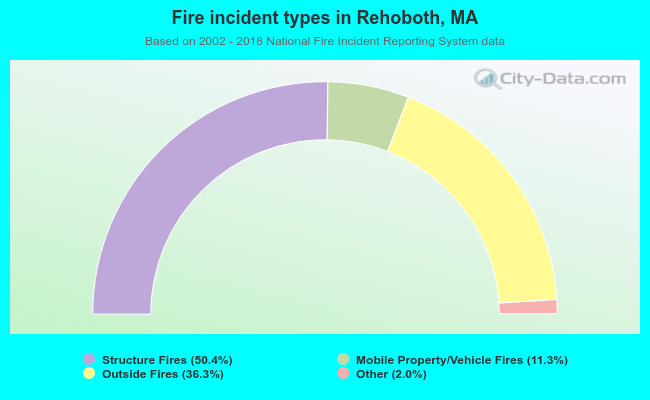 When looking into fire subcategories, the most reports belonged to: Structure Fires (50.4%), and Outside Fires (36.3%).
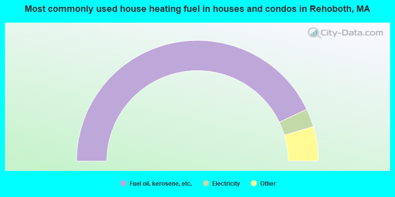
- 85.9%Fuel oil, kerosene, etc.
- 4.9%Electricity
- 3.6%Bottled, tank, or LP gas
- 3.0%Wood
- 1.8%Utility gas
- 0.4%Coal or coke
- 0.4%Other fuel
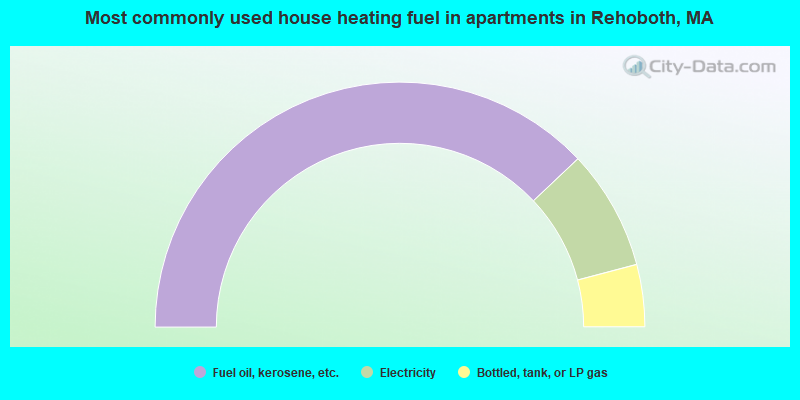
- 75.9%Fuel oil, kerosene, etc.
- 15.9%Electricity
- 8.2%Bottled, tank, or LP gas
Rehoboth compared to Massachusetts state average:
- Unemployed percentage significantly below state average.
- Black race population percentage significantly below state average.
- Hispanic race population percentage significantly below state average.
- Median age above state average.
- Foreign-born population percentage significantly below state average.
- Renting percentage significantly below state average.
- Length of stay since moving in significantly above state average.
- Number of rooms per house significantly below state average.
- House age significantly below state average.
Rehoboth on our top lists:
- #9 on the list of "Top 101 cities with largest percentage of males in occupations: other healthcare support occupations (population 5,000+)"
- #30 on the list of "Top 101 cities with largest percentage of females in industries: jewelry, luggage, and leather goods stores (population 5,000+)"
- #35 on the list of "Top 101 cities with largest percentage of females in occupations: social scientists and related workers (population 5,000+)"
- #36 on the list of "Top 101 cities with largest percentage of females in occupations: architects, surveyors, and cartographers (population 5,000+)"
- #44 on the list of "Top 101 cities with largest percentage of females in occupations: registered nurses (population 5,000+)"
- #51 on the list of "Top 101 cities with largest percentage of females in occupations: supervisors and other personal care and service workers except personal appearance, transportation, and child care workers (population 5,000+)"
- #53 on the list of "Top 101 cities with largest percentage of females in industries: miscellaneous manufacturing (population 5,000+)"
- #55 on the list of "Top 101 cities with largest percentage of males in industries: furniture and home furnishings, and household appliance stores (population 5,000+)"
- #60 on the list of "Top 101 cities with largest percentage of males in industries: miscellaneous nondurable goods merchant wholesalers (population 5,000+)"
- #63 on the list of "Top 101 cities with largest percentage of males in industries: farm product raw materials merchant wholesalers (population 5,000+)"
- #66 on the list of "Top 101 cities with largest percentage of males in occupations: motor vehicle operators except bus and truck drivers (population 5,000+)"
- #70 on the list of "Top 101 cities with largest percentage of females in industries: drugs, sundries, and chemical and allied products merchant wholesalers (population 5,000+)"
- #84 on the list of "Top 101 cities with largest percentage of males in industries: retail florists (population 5,000+)"
- #87 on the list of "Top 101 cities with largest percentage of males in industries: miscellaneous manufacturing (population 5,000+)"
- #99 on the list of "Top 101 cities with largest percentage of males in industries: jewelry, luggage, and leather goods stores (population 5,000+)"
- #99 on the list of "Top 101 cities with largest percentage of males in industries: u. s. postal service (population 5,000+)"
- #58 (02769) on the list of "Top 101 zip codes with the largest percentage of Portuguese first ancestries (pop 5,000+)"
- #14 on the list of "Top 101 counties with the lowest percentage of residents that keep firearms around their homes"
- #29 on the list of "Top 101 counties with the lowest percentage of residents relocating to foreign countries in 2011 (pop. 50,000+)"
- #32 on the list of "Top 101 counties with the most Catholic congregations"
- #34 on the list of "Top 101 counties with the highest percentage of residents that smoked 100+ cigarettes in their lives"
- #41 on the list of "Top 101 counties with the most Catholic adherents"

|
|
Total of 116 patent applications in 2008-2024.