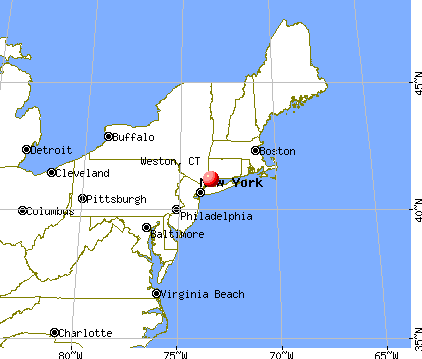
Weston, Connecticut
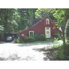
Submit your own pictures of this town and show them to the world
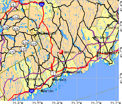
- OSM Map
- General Map
- Google Map
- MSN Map
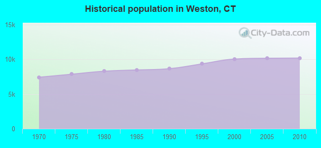
Population change since 2000: +1.4%
 |
| Males: 5,035 | |
| Females: 5,144 |
| Median resident age: | 43.4 years |
| Connecticut median age: | 39.2 years |
Zip codes: 06883.
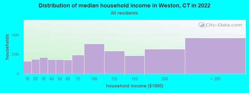
| Weston: | over $200,000 |
| CT: | $88,429 |
Estimated per capita income in 2022: $134,156 (it was $74,817 in 2000)
Weston town income, earnings, and wages data
Estimated median house or condo value in 2022: over $1,000,000 (it was $633,100 in 2000)
| Weston: | over $1,000,000 |
| CT: | $347,200 |
Mean prices in 2022: all housing units: $773,995; detached houses: $872,764; townhouses or other attached units: $449,164; in 2-unit structures: $329,188; in 3-to-4-unit structures: $346,815; in 5-or-more-unit structures: $346,835; mobile homes: $65,227
Detailed information about poverty and poor residents in Weston, CT
Compare current foreclosures near Weston, CT:
| Photo | Address | Area | Beds / Baths | Price | Details |
|---|---|---|---|---|---|

|
#1
Mountain View Dr
Weston, CT 06883
|
4,687 sq. feet
|
3 baths 4 beds |
show details | |

|
#2
Briar Oak Dr
Weston, CT 06883
|
2,634 sq. feet
|
3 baths 4 beds |
show details | |

|
#3
Briar Oak Dr
Weston, CT 06883
|
2,463 sq. feet
|
3 baths 4 beds |
show details | |

|
#4
Ravenwood Dr
Weston, CT 06883
|
1,469 sq. feet
|
2 baths 3 beds |
show details | |

|
#5
Newtown Tpke
Weston, CT 06883
|
6,141 sq. feet
|
5 baths 4 beds |
show details | |

|
#6
Plymouth St
Stratford, CT 06614
|
1,824 sq. feet
|
2 baths 3 beds |
$499,900
|
show details |

|
#7
Olcott Way # 122
Ridgefield, CT 06877
|
920 sq. feet
|
1 baths 1 beds |
$364,900
|
show details |

|
#8
Abbott Ave
Danbury, CT 06810
|
1,401 sq. feet
|
1 baths 3 beds |
$499,900
|
show details |

|
#9
Beecher Ave
Shelton, CT 06484
|
1,911 sq. feet
|
2 baths 4 beds |
$589,900
|
show details |

|
#10
Limerick St
Stamford, CT 06902
|
1,382 sq. feet
|
4 baths 5 beds |
$919,900
|
show details |
| Photo | Address | Area | Beds / Baths | Price | Details |
|---|---|---|---|---|---|

|
#11
Highland Park Dr
Danbury, CT 06811
|
875 sq. feet
|
2 baths 2 beds |
$460,000
|
show details |

|
#12
Santangelo Terrace #30
Derby, CT 06418
|
652 sq. feet
|
1 baths 1 beds |
$189,000
|
show details |

|
#13
Lynne Pl
Bridgeport, CT 06610
|
1,152 sq. feet
|
2 baths 3 beds |
$389,900
|
show details |

|
#14
Partridge Dr
Seymour, CT 06483
|
1,500 sq. feet
|
1 baths 3 beds |
$300,000
|
show details |

|
#15
Lindley St
Bridgeport, CT 06606
|
- sq. feet
|
2 baths 4 beds |
$421,900
|
show details |

|
#16
Sasco Hill Rd
Fairfield, CT 06824
|
- sq. feet
|
4 baths 5 beds |
$6,700,000
|
show details |

|
#17
Talmadge Hill Rd
Darien, CT 06820
|
- sq. feet
|
4 baths 5 beds |
$2,395,000
|
show details |

|
#18
Vista St
Stamford, CT 06902
|
2,240 sq. feet
|
3 baths 7 beds |
show details | |

|
#19
Remington St
Bridgeport, CT 06610
|
1,292 sq. feet
|
1 baths 3 beds |
show details | |

|
#20
Patricia Rd Unit B
Bridgeport, CT 06606
|
1,275 sq. feet
|
1 baths 2 beds |
show details |
| Photo | Address | Area | Beds / Baths | Price | Details |
|---|---|---|---|---|---|

|
#21
Buttery Rd
New Canaan, CT 06840
|
1,986 sq. feet
|
2 baths 4 beds |
show details | |

|
#22
Lockwood Rd
Fairfield, CT 06825
|
3,635 sq. feet
|
2 baths 5 beds |
show details | |

|
#23
Northill St Apt 2x
Stamford, CT 06907
|
1,076 sq. feet
|
2 baths 2 beds |
show details | |

|
#24
Wyndover Ln
Stamford, CT 06902
|
4,398 sq. feet
|
3 baths 3 beds |
show details | |

|
#25
Wooster St
Bethel, CT 06801
|
2,573 sq. feet
|
3 baths 5 beds |
show details | |

|
#26
High View Dr
Stratford, CT 06614
|
2,574 sq. feet
|
2 baths 4 beds |
show details | |

|
#27
Lexington Ave Apt 203
Bridgeport, CT 06604
|
715 sq. feet
|
1 baths 1 beds |
show details | |

|
#28
Park Ave Unit 22
Bridgeport, CT 06604
|
2,296 sq. feet
|
2 baths 2 beds |
show details | |

|
#29
Harris St
Norwalk, CT 06850
|
1,176 sq. feet
|
2 baths 3 beds |
show details | |

|
#30
Beechwood Ave
Bridgeport, CT 06604
|
2,167 sq. feet
|
2 baths 3 beds |
show details |
| Photo | Address | Area | Beds / Baths | Price | Details |
|---|---|---|---|---|---|

|
#31
-337 Ridgefield Ave
Bridgeport, CT 06610
|
3,679 sq. feet
|
3 baths 6 beds |
show details | |

|
#32
High Meadow Rd
Southport, CT 06890
|
3,566 sq. feet
|
3 baths 4 beds |
show details | |

|
#33
Madison Ave
Bridgeport, CT 06606
|
1,100 sq. feet
|
1 baths 3 beds |
show details | |

|
#34
Courtland Ave Apt 2w
Stamford, CT 06902
|
1,032 sq. feet
|
2 baths 2 beds |
show details | |

|
#35
Soundview Ave Unit 60
Stamford, CT 06902
|
2,189 sq. feet
|
1 baths 3 beds |
show details | |

|
#36
Huntington Ct
Bethel, CT 06801
|
1,312 sq. feet
|
1 baths 2 beds |
show details | |

|
#37
82 Herkimer St
Bridgeport, CT 06604
|
- sq. feet
|
3 baths 5 beds |
show details | |

|
#38
Overlook Ave
Bridgeport, CT 06606
|
1,232 sq. feet
|
2 baths 3 beds |
show details | |

|
#39
Weber Ave
Bridgeport, CT 06610
|
1,322 sq. feet
|
2 baths 3 beds |
show details | |

|
#40
Horseshoe Dr
Trumbull, CT 06611
|
2,546 sq. feet
|
2 baths 4 beds |
show details |
| Photo | Address | Area | Beds / Baths | Price | Details |
|---|---|---|---|---|---|

|
#41
Chestnut Hill Rd
Wilton, CT 06897
|
4,630 sq. feet
|
4 baths 5 beds |
show details | |

|
#42
Rennell St
Bridgeport, CT 06604
|
1,419 sq. feet
|
1 baths 3 beds |
show details | |

|
#43
Great Plain Road15
Danbury, CT 06811
|
715 sq. feet
|
1 baths 1 beds |
show details | |

|
#44
Daniel Ct
Westport, CT 06880
|
4,566 sq. feet
|
4 baths 4 beds |
show details | |

|
#45
Broadbridge Rd
Bridgeport, CT 06610
|
1,310 sq. feet
|
2 baths 2 beds |
show details | |

|
#46
Wood Acres Lane
Monroe, CT 06468
|
3,159 sq. feet
|
4 baths 4 beds |
show details | |

|
#47
Upland Ct
Norwalk, CT 06854
|
1,368 sq. feet
|
1 baths 4 beds |
show details | |

|
#48
Oak Crest Dr
Brookfield, CT 06804
|
2,074 sq. feet
|
1 baths 3 beds |
show details | |

|
#49
Elm St
Monroe, CT 06468
|
2,450 sq. feet
|
2 baths 3 beds |
show details | |

|
Check over 1 million property listings on Foreclosure.com!
|
browse all offers | |||

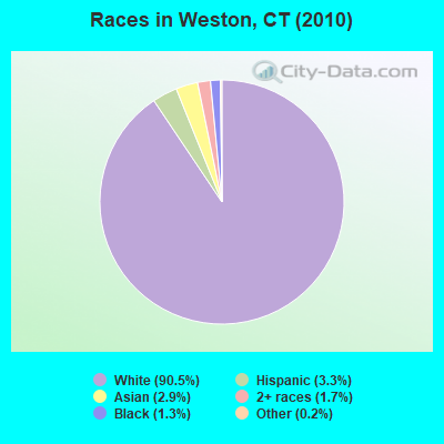
- 9,21290.5%White alone
- 3363.3%Hispanic
- 2932.9%Asian alone
- 1771.7%Two or more races
- 1301.3%Black alone
- 190.2%Other race alone
- 100.10%American Indian alone
- 20.02%Native Hawaiian and Other
Pacific Islander alone
Races in Weston detailed stats: ancestries, foreign born residents, place of birth
According to our research of Connecticut and other state lists, there was 1 registered sex offender living in Weston, Connecticut as of April 27, 2024.
The ratio of all residents to sex offenders in Weston is 10,179 to 1.
The ratio of registered sex offenders to all residents in this city is much lower than the state average.
Type |
2009 |
2010 |
2011 |
2012 |
2013 |
2014 |
2015 |
2016 |
2017 |
2018 |
2019 |
2020 |
2021 |
2022 |
|---|---|---|---|---|---|---|---|---|---|---|---|---|---|---|
| Murders (per 100,000) | 0 (0.0) | 0 (0.0) | 0 (0.0) | 0 (0.0) | 0 (0.0) | 0 (0.0) | 0 (0.0) | 0 (0.0) | 0 (0.0) | 0 (0.0) | 0 (0.0) | 0 (0.0) | 0 (0.0) | 0 (0.0) |
| Rapes (per 100,000) | 0 (0.0) | 1 (9.8) | 0 (0.0) | 0 (0.0) | 1 (9.6) | 0 (0.0) | 0 (0.0) | 0 (0.0) | 0 (0.0) | 0 (0.0) | 0 (0.0) | 0 (0.0) | 0 (0.0) | 0 (0.0) |
| Robberies (per 100,000) | 0 (0.0) | 0 (0.0) | 0 (0.0) | 0 (0.0) | 0 (0.0) | 0 (0.0) | 0 (0.0) | 0 (0.0) | 0 (0.0) | 0 (0.0) | 0 (0.0) | 0 (0.0) | 0 (0.0) | 0 (0.0) |
| Assaults (per 100,000) | 2 (19.6) | 0 (0.0) | 1 (9.8) | 3 (29.1) | 0 (0.0) | 2 (19.2) | 1 (9.6) | 0 (0.0) | 4 (38.8) | 0 (0.0) | 0 (0.0) | 0 (0.0) | 0 (0.0) | 0 (0.0) |
| Burglaries (per 100,000) | 6 (58.8) | 7 (68.8) | 9 (88.3) | 11 (106.7) | 13 (125.0) | 6 (57.6) | 3 (28.7) | 1 (9.6) | 1 (9.7) | 0 (0.0) | 1 (9.8) | 2 (19.5) | 1 (9.8) | 1 (9.7) |
| Thefts (per 100,000) | 53 (519.8) | 58 (569.8) | 44 (431.5) | 30 (291.0) | 24 (230.7) | 27 (259.2) | 20 (191.6) | 14 (134.3) | 32 (310.1) | 25 (241.5) | 14 (136.5) | 15 (146.2) | 8 (78.4) | 12 (115.9) |
| Auto thefts (per 100,000) | 2 (19.6) | 3 (29.5) | 1 (9.8) | 0 (0.0) | 0 (0.0) | 0 (0.0) | 1 (9.6) | 0 (0.0) | 4 (38.8) | 2 (19.3) | 0 (0.0) | 10 (97.5) | 4 (39.2) | 9 (87.0) |
| Arson (per 100,000) | 1 (9.8) | 1 (9.8) | 1 (9.8) | 0 (0.0) | 0 (0.0) | 0 (0.0) | 0 (0.0) | 0 (0.0) | 0 (0.0) | 0 (0.0) | 0 (0.0) | 0 (0.0) | 0 (0.0) | 0 (0.0) |
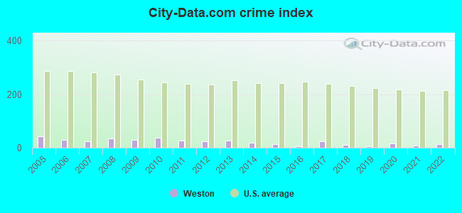
| City-Data.com crime index | 30.4 | 37.8 | 26.2 | 24.9 | 25.7 | 18.2 | 12.4 | 6.0 | 23.9 | 11.2 | 6.1 | 15.0 | 7.0 | 12.3 |
The City-Data.com crime index weighs serious crimes and violent crimes more heavily. Higher means more crime, U.S. average is 246.1. It adjusts for the number of visitors and daily workers commuting into cities.
Crime rate in Weston detailed stats: murders, rapes, robberies, assaults, burglaries, thefts, arson
Full-time law enforcement employees in 2021, including police officers: 18 (17 officers - 17 male; 0 female).
| Officers per 1,000 residents here: | 1.67 |
| Connecticut average: | 2.10 |
 Recent articles from our blog. Our writers, many of them Ph.D. graduates or candidates, create easy-to-read articles on a wide variety of topics.

Latest news from Weston, CT collected exclusively by city-data.com from local newspapers, TV, and radio stations
Ancestries: Irish (17.7%), Italian (13.9%), English (13.7%), German (13.4%), United States (7.0%), Russian (6.9%).
Current Local Time: EST time zone
Incorporated on 10/1787
Elevation: 311 feet
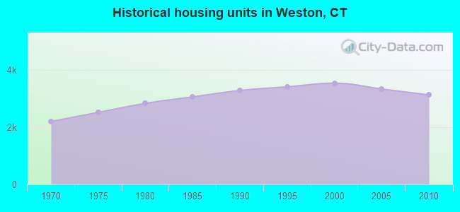
Land area: 19.8 square miles.
Population density: 514 people per square mile (low).
821 residents are foreign born (4.5% Europe, 1.3% Asia, 1.0% Latin America).
| This town: | 8.2% |
| Connecticut: | 10.9% |
| Weston town: | 1.1% ($7,029) |
| Connecticut: | 1.8% ($2,961) |
Nearest city with pop. 50,000+: Fairfield, CT  (6.9 miles , pop. 57,340).
Nearest city with pop. 200,000+: North Hempstead, NY (34.0 miles , pop. 222,611).
Nearest city with pop. 1,000,000+: Bronx, NY (36.5 miles , pop. 1,332,650).
Nearest cities:
), ), ), ), Latitude: 41.22 N, Longitude: 73.37 W
Area code commonly used in this area: 203

Weston, Connecticut accommodation & food services, waste management - Economy and Business Data
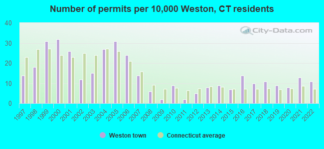
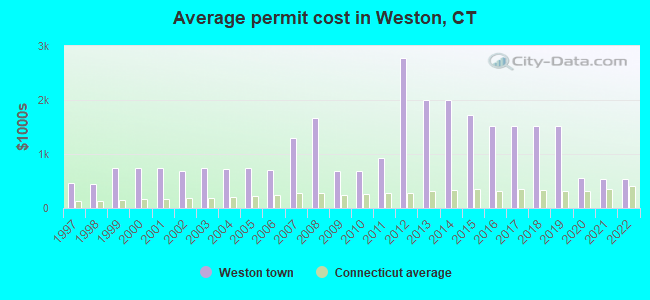
Single-family new house construction building permits:
- 2022: 11 buildings, average cost: $544,100
- 2021: 13 buildings, average cost: $543,400
- 2020: 8 buildings, average cost: $551,000
- 2019: 9 buildings, average cost: $1,519,600
- 2018: 11 buildings, average cost: $1,519,600
- 2017: 10 buildings, average cost: $1,519,600
- 2016: 14 buildings, average cost: $1,519,600
- 2015: 7 buildings, average cost: $1,714,300
- 2014: 9 buildings, average cost: $2,000,000
- 2013: 8 buildings, average cost: $2,000,000
- 2012: 5 buildings, average cost: $2,770,200
- 2011: 2 buildings, average cost: $930,000
- 2010: 9 buildings, average cost: $677,400
- 2009: 2 buildings, average cost: $693,500
- 2008: 6 buildings, average cost: $1,666,700
- 2007: 14 buildings, average cost: $1,300,000
- 2006: 24 buildings, average cost: $701,800
- 2005: 31 buildings, average cost: $734,200
- 2004: 27 buildings, average cost: $725,600
- 2003: 15 buildings, average cost: $742,300
- 2002: 12 buildings, average cost: $689,900
- 2001: 26 buildings, average cost: $741,100
- 2000: 32 buildings, average cost: $741,500
- 1999: 31 buildings, average cost: $739,000
- 1998: 18 buildings, average cost: $448,000
- 1997: 14 buildings, average cost: $457,700
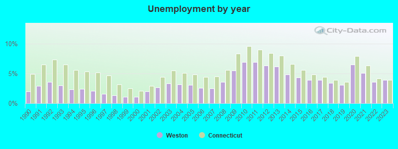
| Here: | 3.9% |
| Connecticut: | 3.9% |
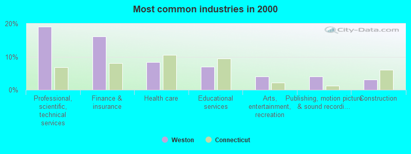
- Professional, scientific, technical services (19.1%)
- Finance & insurance (16.1%)
- Health care (8.4%)
- Educational services (7.0%)
- Arts, entertainment, recreation (4.0%)
- Publishing, motion picture & sound recording industries (4.0%)
- Construction (3.1%)
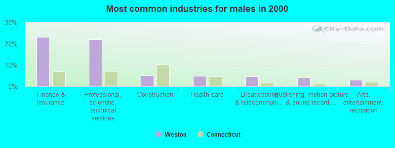
- Finance & insurance (23.2%)
- Professional, scientific, technical services (22.1%)
- Construction (5.0%)
- Health care (4.9%)
- Broadcasting & telecommunications (4.6%)
- Publishing, motion picture & sound recording industries (4.1%)
- Arts, entertainment, recreation (3.1%)
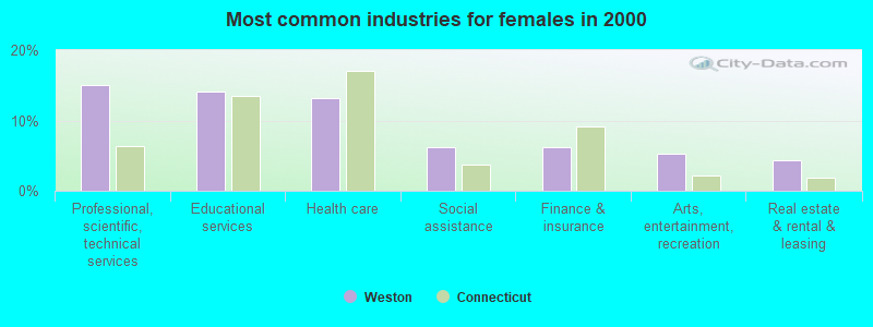
- Professional, scientific, technical services (15.0%)
- Educational services (14.2%)
- Health care (13.2%)
- Social assistance (6.2%)
- Finance & insurance (6.2%)
- Arts, entertainment, recreation (5.3%)
- Real estate & rental & leasing (4.3%)
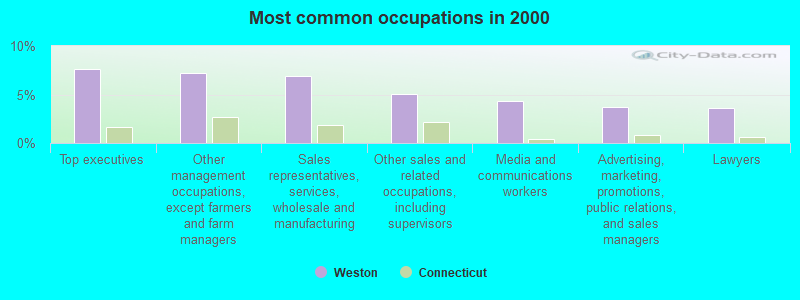
- Top executives (7.6%)
- Other management occupations, except farmers and farm managers (7.2%)
- Sales representatives, services, wholesale and manufacturing (6.9%)
- Other sales and related occupations, including supervisors (5.0%)
- Media and communications workers (4.3%)
- Advertising, marketing, promotions, public relations, and sales managers (3.7%)
- Lawyers (3.6%)
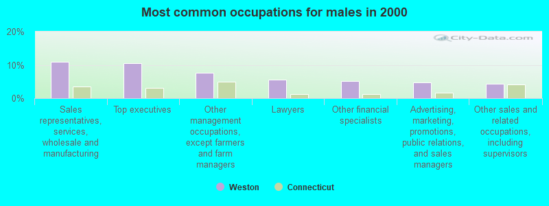
- Sales representatives, services, wholesale and manufacturing (10.9%)
- Top executives (10.5%)
- Other management occupations, except farmers and farm managers (7.6%)
- Lawyers (5.6%)
- Other financial specialists (5.1%)
- Advertising, marketing, promotions, public relations, and sales managers (4.8%)
- Other sales and related occupations, including supervisors (4.4%)
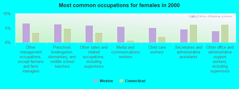
- Other management occupations, except farmers and farm managers (6.7%)
- Preschool, kindergarten, elementary, and middle school teachers (6.4%)
- Other sales and related occupations, including supervisors (6.0%)
- Media and communications workers (5.6%)
- Child care workers (5.1%)
- Secretaries and administrative assistants (4.7%)
- Other office and administrative support workers, including supervisors (4.1%)
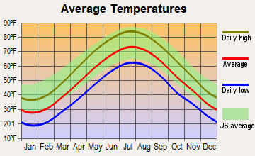
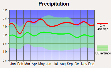
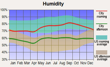
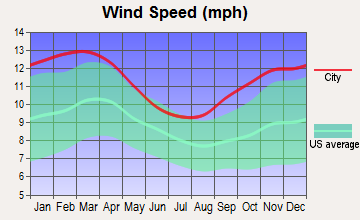
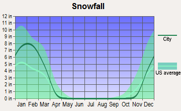
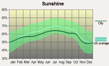
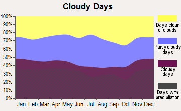
Average climate in Weston, Connecticut
Based on data reported by over 4,000 weather stations
(lower is better)
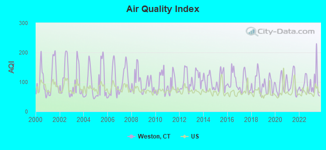
Air Quality Index (AQI) level in 2023 was 95.5. This is worse than average.
| City: | 95.5 |
| U.S.: | 72.6 |
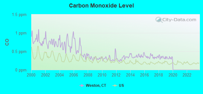
Carbon Monoxide (CO) [ppm] level in 2019 was 0.322. This is worse than average. Closest monitor was 7.0 miles away from the city center.
| City: | 0.322 |
| U.S.: | 0.251 |
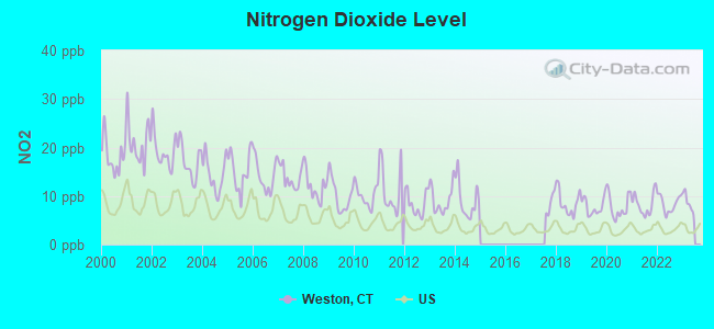
Nitrogen Dioxide (NO2) [ppb] level in 2022 was 8.39. This is significantly worse than average. Closest monitor was 7.0 miles away from the city center.
| City: | 8.39 |
| U.S.: | 5.11 |
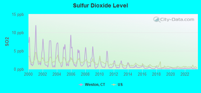
Sulfur Dioxide (SO2) [ppb] level in 2022 was 0.221. This is significantly better than average. Closest monitor was 7.0 miles away from the city center.
| City: | 0.221 |
| U.S.: | 1.515 |
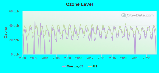
Ozone [ppb] level in 2023 was 30.6. This is about average. Closest monitor was 9.7 miles away from the city center.
| City: | 30.6 |
| U.S.: | 33.3 |
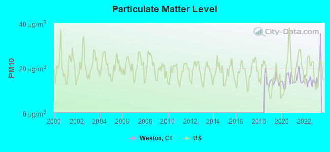
Particulate Matter (PM10) [µg/m3] level in 2022 was 14.3. This is better than average. Closest monitor was 7.0 miles away from the city center.
| City: | 14.3 |
| U.S.: | 19.2 |
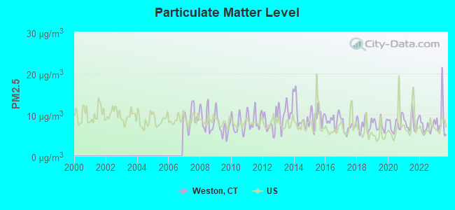
Particulate Matter (PM2.5) [µg/m3] level in 2023 was 8.74. This is about average. Closest monitor was 7.0 miles away from the city center.
| City: | 8.74 |
| U.S.: | 8.11 |
Tornado activity:
Weston-area historical tornado activity is slightly below Connecticut state average. It is 38% smaller than the overall U.S. average.
On 7/10/1989, a category F4 (max. wind speeds 207-260 mph) tornado 24.6 miles away from the Weston town center injured 40 people and caused between $50,000,000 and $500,000,000 in damages.
On 5/24/1962, a category F3 (max. wind speeds 158-206 mph) tornado 26.5 miles away from the town center killed one person and injured 50 people and caused between $500,000 and $5,000,000 in damages.
Earthquake activity:
Weston-area historical earthquake activity is significantly above Connecticut state average. It is 70% smaller than the overall U.S. average.On 10/7/1983 at 10:18:46, a magnitude 5.3 (5.1 MB, 5.3 LG, 5.1 ML, Class: Moderate, Intensity: VI - VII) earthquake occurred 195.6 miles away from Weston center
On 4/20/2002 at 10:50:47, a magnitude 5.3 (5.3 ML, Depth: 3.0 mi) earthquake occurred 228.6 miles away from the city center
On 8/23/2011 at 17:51:04, a magnitude 5.8 (5.8 MW, Depth: 3.7 mi) earthquake occurred 333.9 miles away from Weston center
On 4/20/2002 at 10:50:47, a magnitude 5.2 (5.2 MB, 4.2 MS, 5.2 MW, 5.0 MW) earthquake occurred 226.9 miles away from Weston center
On 1/16/1994 at 01:49:16, a magnitude 4.6 (4.6 MB, 4.6 LG, Depth: 3.1 mi, Class: Light, Intensity: IV - V) earthquake occurred 152.4 miles away from Weston center
On 1/19/1982 at 00:14:42, a magnitude 4.7 (4.5 MB, 4.7 MD, 4.5 LG) earthquake occurred 182.1 miles away from Weston center
Magnitude types: regional Lg-wave magnitude (LG), body-wave magnitude (MB), duration magnitude (MD), local magnitude (ML), surface-wave magnitude (MS), moment magnitude (MW)
Natural disasters:
The number of natural disasters in Fairfield County (24) is greater than the US average (15).Major Disasters (Presidential) Declared: 13
Emergencies Declared: 11
Causes of natural disasters: Storms: 6, Floods: 5, Hurricanes: 5, Snowstorms: 4, Blizzards: 3, Snows: 3, Winter Storms: 3, Tropical Storms: 2, Snowfall: 1, Wind: 1 (Note: some incidents may be assigned to more than one category).

Hospitals and medical centers near Weston:
- MEADOW RIDGE (Nursing Home, about 5 miles away; WEST REDDING, CT)
- LOURDES HEALTH CARE CENTER, IN (Nursing Home, about 5 miles away; WILTON, CT)
- VISITING NURSE AND HOSPICE OF FAIRFIELD COUNTY, INC (Home Health Center, about 5 miles away; NORWALK, CT)
- WESTPORT HEALTH CARE CTR (Nursing Home, about 6 miles away; WESTPORT, CT)
- AURORA SENIOR LIVING OF NORWALK (Nursing Home, about 6 miles away; NORWALK, CT)
- SILVER HILL HOSPITAL INC (Hospital, about 7 miles away; NEW CANAAN, CT)
- JEWISH HM FOR THE ELDERLY FAIR (Nursing Home, about 7 miles away; FAIRFIELD, CT)
Amtrak stations near Weston:
- 11 miles: BRIDGEPORT (525 WATER ST.) . Services: fully wheelchair accessible, enclosed waiting area, public restrooms, public payphones, snack bar, paid short-term parking, paid long-term parking, call for car rental service, taxi stand, intercity bus service, public transit connection.
- 15 miles: STAMFORD (WASHINGTON BLVD. & E. STATE ST.) . Services: ticket office, fully wheelchair accessible, enclosed waiting area, public restrooms, public payphones, snack bar, ATM, paid short-term parking, paid long-term parking, call for car rental service, taxi stand, public transit connection.
Colleges/universities with over 2000 students nearest to Weston:
- Sacred Heart University (about 7 miles; Fairfield, CT; Full-time enrollment: 5,650)
- Fairfield University (about 8 miles; Fairfield, CT; FT enrollment: 4,640)
- Norwalk Community College (about 9 miles; Norwalk, CT; FT enrollment: 4,085)
- Housatonic Community College (about 10 miles; Bridgeport, CT; FT enrollment: 3,677)
- University of Bridgeport (about 11 miles; Bridgeport, CT; FT enrollment: 3,708)
- Porter and Chester Institute of Stratford (about 13 miles; Stratford, CT; FT enrollment: 2,822)
- Western Connecticut State University (about 14 miles; Danbury, CT; FT enrollment: 5,345)
Public high school in Weston:
- WESTON HIGH SCHOOL (Students: 550, Location: 115 SCHOOL ROAD, Grades: 9-12)
Public elementary/middle schools in Weston:
- WESTON MIDDLE SCHOOL (Students: 1,046, Location: 135 SCHOOL ROAD, Grades: 6-8)
- HURLBUTT ELEMENTARY SCHOOL (Students: 931, Location: 9 SCHOOL ROAD, Grades: PK-2)
- WESTON INTERMEDIATE SCHOOL (Students: 41, Location: 95 SCHOOL ROAD, Grades: 3-5)
Library in Weston:
- WESTON PUBLIC LIBRARY (Operating income: $378,735; Location: 56 NORFIELD RD.; 48,221 books; 4,188 e-books; 2,347 audio materials; 3,565 video materials; 1 local licensed databases; 34 state licensed databases; 3 other licensed databases; 128 print serial subscriptions; 3 electronic serial subscriptions)
User-submitted facts and corrections:
- Weston now has a new school: Weston Intermediate School (grades 3-4-5) so now Hurlbutt has PK-2 and the middle school has 6-8 (highschool 9-12) The 2nd murder ever in Weston(2003) was comitted by a man with mental dissabilities, killed his Father. So, really Weston is quite safe.
Points of interest:
Notable locations in Weston: Aspetuck Valley Country Club (A), Weston Public Library (B), Weston Volunteer Emergency Medical Services (C), Weston Volunteer Fire Department Station 2 (D), Weston Town Fire Chief's Office (E), Weston Volunteer Fire Department Station 1 Headquarters (F). Display/hide their locations on the map
Churches in Weston include: Emmanuel Episcopal Church (A), Saint Francis of Assisi Church (B). Display/hide their locations on the map
Cemetery: Coleytown Cemetery (1). Display/hide its location on the map
Lakes and reservoirs: Cobbs Mill Pond (A), Davidge Pond (B), Godfrey Pond (C), Laurel Lake (D), Princes Pond (E), Beaver Brook Pond (F), Held Pond (G), Saugatuck Reservoir (H). Display/hide their locations on the map
Streams, rivers, and creeks: North Branch West Branch Saugatuck River (A), Beaver Brook (B), Davidge Brook (C), Godfrey Brook (D), Hawleys Brook (E), Jennings Brook (F), Kettle Creek (G). Display/hide their locations on the map
Parks in Weston include: Scribner Park (1), Devils Glen Park (2). Display/hide their locations on the map
Birthplace of: Jared Cohen - Non-fiction writer, Mariette Hartley - Actress, Rob Sisca - College basketball player (Vermont Catamounts).
Drinking water stations with addresses in Weston that have no violations reported:
- WESTON RACQUET CLUB (Population served: 25, Primary Water Source Type: Groundwater)
| This town: | 3.0 people |
| Connecticut: | 2.5 people |
| This town: | 84.5% |
| Whole state: | 66.3% |
| This town: | 2.6% |
| Whole state: | 6.6% |
Likely homosexual households (counted as self-reported same-sex unmarried-partner households)
- Lesbian couples: 0.2% of all households
- Gay men: 0.6% of all households
| This town: | 1.9% |
| Whole state: | 7.9% |
| This town: | 1.2% |
| Whole state: | 3.9% |
Banks with branches in Weston (2011 data):
- Fairfield County Bank: Weston Branch at 190 Weston Road, branch established on 2007/05/04. Info updated 2012/01/12: Bank assets: $1,441.4 mil, Deposits: $1,172.5 mil, headquarters in Ridgefield, CT, positive income, Commercial Lending Specialization, 22 total offices
For population 15 years and over in Weston:
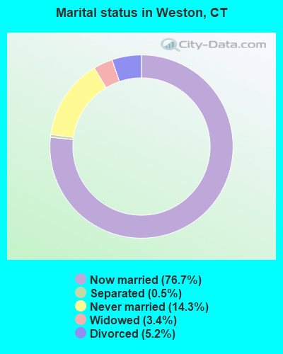
- Never married: 14.3%
- Now married: 76.7%
- Separated: 0.5%
- Widowed: 3.4%
- Divorced: 5.2%
For population 25 years and over in Weston:
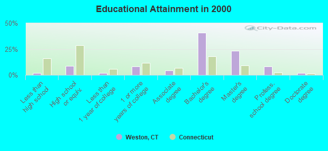
- High school or higher: 98.1%
- Bachelor's degree or higher: 74.4%
- Graduate or professional degree: 33.7%
- Unemployed: 1.2%
- Mean travel time to work (commute): 41.6 minutes
| Here: | 8.0 |
| Connecticut average: | 12.8 |
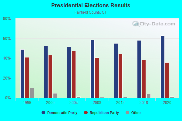
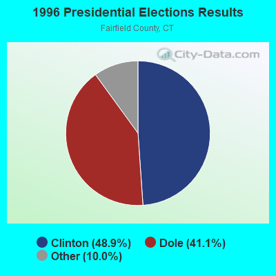
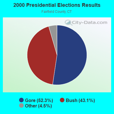
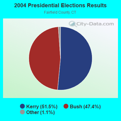
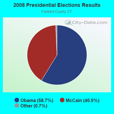
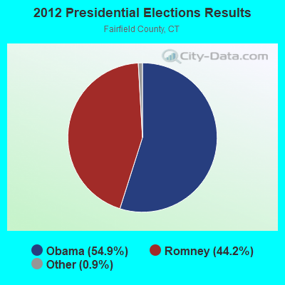
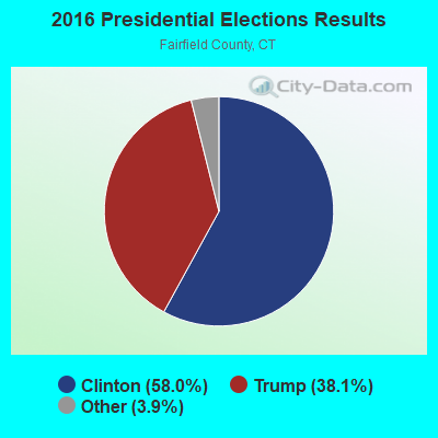
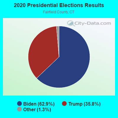
Graphs represent county-level data. Detailed 2008 Election Results
Religion statistics for Weston, CT (based on Fairfield County data)
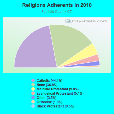
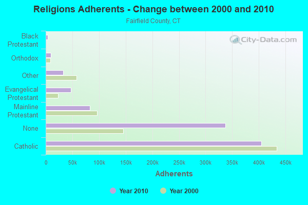
| Religion | Adherents | Congregations |
|---|---|---|
| Catholic | 404,341 | 94 |
| Mainline Protestant | 82,604 | 175 |
| Evangelical Protestant | 46,888 | 242 |
| Other | 32,501 | 95 |
| Orthodox | 9,215 | 21 |
| Black Protestant | 4,144 | 27 |
| None | 337,136 | - |
Food Environment Statistics:
| Fairfield County: | 2.50 / 10,000 pop. |
| State: | 2.21 / 10,000 pop. |
| Fairfield County: | 0.06 / 10,000 pop. |
| Connecticut: | 0.07 / 10,000 pop. |
| Fairfield County: | 0.85 / 10,000 pop. |
| State: | 1.02 / 10,000 pop. |
| Here: | 1.70 / 10,000 pop. |
| Connecticut: | 2.27 / 10,000 pop. |
| Fairfield County: | 9.67 / 10,000 pop. |
| State: | 9.19 / 10,000 pop. |
| Here: | 6.5% |
| Connecticut: | 7.3% |
| Fairfield County: | 17.9% |
| Connecticut: | 21.5% |
| Fairfield County: | 17.2% |
| Connecticut: | 15.8% |
5.92% of this county's 2021 resident taxpayers lived in other counties in 2020 ($194,373 average adjusted gross income)
| Here: | 5.92% |
| Connecticut average: | 5.79% |
0.01% of residents moved from foreign countries ($50 average AGI)
Fairfield County: 0.01% Connecticut average: 0.02%
Top counties from which taxpayers relocated into this county between 2020 and 2021:
| from Westchester County, NY | |
| from New York County, NY | |
| from New Haven County, CT |
6.13% of this county's 2020 resident taxpayers moved to other counties in 2021 ($174,109 average adjusted gross income)
| Here: | 6.13% |
| Connecticut average: | 5.82% |
0.01% of residents moved to foreign countries ($428 average AGI)
Fairfield County: 0.01% Connecticut average: 0.02%
Top counties to which taxpayers relocated from this county between 2020 and 2021:
| to New Haven County, CT | |
| to New York County, NY | |
| to Westchester County, NY |
Strongest AM radio stations in Weston:
- WFAN (660 AM; 50 kW; NEW YORK, NY; Owner: INFINITY BROADCASTING OPERATIONS, INC.)
- WCBS (880 AM; 50 kW; NEW YORK, NY; Owner: INFINITY BROADCASTING OPERATIONS, INC.)
- WGSM (740 AM; 25 kW; HUNTINGTON, NY; Owner: K RADIO LICENSEE, INC.)
- WREF (850 AM; 2 kW; RIDGEFIELD, CT; Owner: THE BERKSHIRE BROADCASTING CORP.)
- WDJZ (1530 AM; daytime; 5 kW; BRIDGEPORT, CT; Owner: PEOPLE'S BROADCAST NETWORK, LLC)
- WABC (770 AM; 50 kW; NEW YORK, NY; Owner: WABC-AM RADIO, INC.)
- WMCA (570 AM; 50 kW; NEW YORK, NY; Owner: SALEM MEDIA OF NEW YORK, LLC)
- WOR (710 AM; 50 kW; NEW YORK, NY; Owner: BUCKLEY BROADCASTING CORPORATION)
- WEPN (1050 AM; 50 kW; NEW YORK, NY; Owner: NEW YORK AM RADIO, LLC)
- WBBR (1130 AM; 50 kW; NEW YORK, NY; Owner: BLOOMBERG COMMUNICATIONS INC.)
- WINS (1010 AM; 50 kW; NEW YORK, NY; Owner: INFINITY BROADCASTING OPERATIONS, INC.)
- WSHU (1260 AM; 1 kW; WESTPORT, CT; Owner: SACRED HEART UNIVERSITY, INC.)
- WTIC (1080 AM; 50 kW; HARTFORD, CT; Owner: INFINITY RADIO OPERATIONS INC.)
Strongest FM radio stations in Weston:
- WEZN-FM (99.9 FM; BRIDGEPORT, CT; Owner: CXR HOLDINGS, INC.)
- WSHU-FM (91.1 FM; FAIRFIELD, CT; Owner: SACRED HEART UNIVERSITY, INC.)
- WPKN (89.5 FM; BRIDGEPORT, CT; Owner: WPKN, INC.)
- WWPT (90.3 FM; WESTPORT, CT; Owner: WESTPORT CT. BOARD OF EDUCATION)
- WDAQ (98.3 FM; DANBURY, CT; Owner: BERKSHIRE BROADCASTING CORP.)
- WMNR (88.1 FM; MONROE, CT; Owner: MONROE BOARD OF EDUCATION)
- WEFX (95.9 FM; NORWALK, CT; Owner: COX RADIO, INC.)
- WEBE (107.9 FM; WESTPORT, CT; Owner: CUMULUS LICENSING CORP.)
- WFAF (106.3 FM; MOUNT KISCO, NY; Owner: CUMULUS LICENSING CORP.)
- WSLX (91.9 FM; NEW CANAAN, CT; Owner: ST. LUKE'S FOUNDATION, INC.)
- WKCI-FM (101.3 FM; HAMDEN, CT; Owner: CLEAR CHANNEL BROADCASTING LICENSES, INC.)
- WMNR-FM1 (88.1 FM; HUNTINGTON, CT; Owner: MONROE BOARD OF EDUCATION)
- WPLJ (95.5 FM; NEW YORK, NY; Owner: WPLJ-FM RADIO, INC.)
- WPLR (99.1 FM; NEW HAVEN, CT; Owner: COX RADIO, INC.)
- WRKI (95.1 FM; BROOKFIELD, CT; Owner: CUMULUS LICENSING CORP.)
- WRXC (90.1 FM; SHELTON, CT; Owner: MONROE BOARD OF EDUCATION)
- WSPK (104.7 FM; POUGHKEEPSIE, NY; Owner: 6 JOHNSON ROAD LICENSES, INC.)
- WALK-FM (97.5 FM; PATCHOGUE, NY; Owner: AMFM RADIO LICENSES, L.L.C.)
- WKCR-FM (89.9 FM; NEW YORK, NY; Owner: TRUSTEES OF COLUMBIA UNIVERSITY IN NEW YORK)
- WKHL (96.7 FM; STAMFORD, CT; Owner: COX RADIO, INC.)
TV broadcast stations around Weston:
- WEDW (Channel 49; BRIDGEPORT, CT; Owner: CONNECTICUT PUBLIC BROADCASTING, INC.)
- WNYW (Channel 5; NEW YORK, NY; Owner: FOX TELEVISION STATIONS, INC.)
- WCBS-TV (Channel 2; NEW YORK, NY; Owner: CBS BROADCASTING INC.)
- WTNH (Channel 8; NEW HAVEN, CT; Owner: WTNH BROADCASTING, INC.)
- WABC-TV (Channel 7; NEW YORK, NY; Owner: AMERICAN BROADCASTING COMPANIES, INC)
- WPIX (Channel 11; NEW YORK, NY; Owner: WPIX, INC.)
- WWOR-TV (Channel 9; SECAUCUS, NJ; Owner: FOX TELEVISION STATIONS, INC.)
- WTIC-TV (Channel 61; HARTFORD, CT; Owner: TRIBUNE TELEVISION COMPANY)
- W11BJ (Channel 11; HARTFORD, CT; Owner: COMMUNICATIONS SITE MANAGEMENT LLC)
- WEDY (Channel 65; NEW HAVEN, CT; Owner: CONNECTICUT PUBLIC BROADCASTING, INC.)
- WCTX (Channel 59; NEW HAVEN, CT; Owner: WTNH BROADCASTING, INC.)
- WNJU (Channel 47; LINDEN, NJ; Owner: WNJU LICENSE CORPORATION)
- WXNY-LP (Channel 32; NEW YORK, NY; Owner: ISLAND BROADCASTING COMPANY)
- WPXN-TV (Channel 31; NEW YORK, NY; Owner: PAXSON COMMUNICATIONS LICENSE COMPANY, LLC)
- WFUT (Channel 68; NEWARK, NJ; Owner: UNIVISION NEW YORK LLC)
- WNBC (Channel 4; NEW YORK, NY; Owner: NATIONAL BROADCASTING COMPANY, INC.)
- WNET (Channel 13; NEWARK, NJ; Owner: EDUCATIONAL BROADCASTING CORPORATION)
- WXTV (Channel 41; PATERSON, NJ; Owner: WXTV LICENSE PARTNERSHIP, G.P.)
- WTXX (Channel 20; WATERBURY, CT; Owner: WTXX INC.)
- WNYE-TV (Channel 25; NEW YORK, NY; Owner: NEW YORK CITY BOARD OF EDUCATION)
- WTBY (Channel 54; POUGHKEEPSIE, NY; Owner: TRINITY BROADCASTING OF NEW YORK, INC.)
- WVIT (Channel 30; NEW BRITAIN, CT; Owner: OUTLET BROADCASTING, INC)
- WKOB-LP (Channel 53; NEW YORK, NY; Owner: WKOB COMMUNICATIONS, INC.)
- WEBR-CA (Channel 17; MANHATTAN, NY; Owner: K LICENSEE INC.)
- WRNN-LP (Channel 57; NYACK, NY; Owner: LP NYACK LIMITED PARTNERSHIP)
- National Bridge Inventory (NBI) Statistics
- 10Number of bridges
- 52ft / 16.5mTotal length
- $6,388,000Total costs
- 36,790Total average daily traffic
- 1,186Total average daily truck traffic
- 54,668Total future (year 2036) average daily traffic
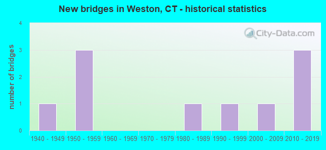
- New bridges - historical statistics
- 11940-1949
- 31950-1959
- 11980-1989
- 11990-1999
- 12000-2009
- 32010-2019
FCC Registered Broadcast Land Mobile Towers:
9 (See the full list of FCC Registered Broadcast Land Mobile Towers in Weston, CT)FCC Registered Microwave Towers:
2- WESTON NORFIELD RD, 52 Norfield Rd (Lat: 41.202417 Lon: -73.379778), Type: Mtower, Structure height: 57.9 m, Call Sign: WSAS344, Licensee ID: L02442623,
Assigned Frequencies: 11565.0 MHz, 11565.0 MHz, 11565.0 MHz, 11565.0 MHz, 11565.0 MHz, 11565.0 MHz, 11565.0 MHz, 11565.0 MHz, Grant Date: 02/08/2024, Expiration Date: 02/08/2034, Certifier: Laurence Roberts, Registrant: Town Of Weston Communications Center, 56 Norfield Road, Weston, CT 06883, Phone: (203) 222-2600, Email:
- WESTON TRANSFR STATI, 237 Godfrey Rd E (Lat: 41.242028 Lon: -73.364306), Type: Mast, Structure height: 54.9 m, Call Sign: WSAS345, Licensee ID: L02442623,
Assigned Frequencies: 11615.0 MHz, 11615.0 MHz, 11615.0 MHz, 11615.0 MHz, 11615.0 MHz, 11615.0 MHz, 11615.0 MHz, 11615.0 MHz, Grant Date: 02/08/2024, Expiration Date: 02/08/2034, Certifier: Laurence Roberts, Registrant: Town Of Weston Communications Center, 56 Norfield Road, Weston, CT 06883, Phone: (203) 222-2600, Email:
FCC Registered Amateur Radio Licenses:
35 (See the full list of FCC Registered Amateur Radio Licenses in Weston)FAA Registered Aircraft:
8 (See the full list of FAA Registered Aircraft in Weston)2002 - 2018 National Fire Incident Reporting System (NFIRS) incidents
- Fire incident types reported to NFIRS in Weston, CT
- 34562.2%Structure Fires
- 14726.5%Outside Fires
- 407.2%Mobile Property/Vehicle Fires
- 234.1%Other
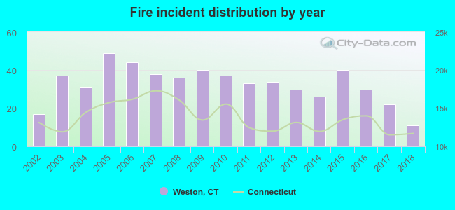 According to the data from the years 2002 - 2018 the average number of fires per year is 33. The highest number of reported fires - 49 took place in 2005, and the least - 11 in 2018. The data has a declining trend.
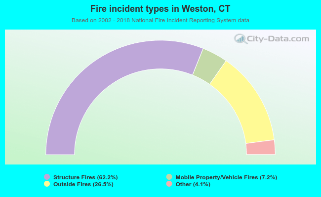 When looking into fire subcategories, the most reports belonged to: Structure Fires (62.2%), and Outside Fires (26.5%).
- 85.6%Fuel oil, kerosene, etc.
- 8.8%Utility gas
- 2.4%Bottled, tank, or LP gas
- 2.2%Electricity
- 0.5%Wood
- 0.4%Other fuel
- 0.2%No fuel used
- 86.7%Fuel oil, kerosene, etc.
- 9.7%Electricity
- 3.5%Bottled, tank, or LP gas
Weston compared to Connecticut state average:
- Median household income significantly above state average.
- Median house value significantly above state average.
- Unemployed percentage significantly below state average.
- Black race population percentage significantly below state average.
- Hispanic race population percentage significantly below state average.
- Median age above state average.
- Foreign-born population percentage below state average.
- Renting percentage significantly below state average.
- Length of stay since moving in significantly above state average.
- Number of rooms per house significantly below state average.
- House age significantly below state average.
- Number of college students below state average.
- Percentage of population with a bachelor's degree or higher significantly above state average.
Weston on our top lists:
- #2 on the list of "Top 101 cities with the highest cost per building permit(population 5,000+)"
- #2 on the list of "Top 101 cities with largest percentage of females in occupations: media and communication equipment workers (population 5,000+)"
- #3 on the list of "Top 101 cities with largest percentage of males in industries: apparel, fabrics, and notions merchant wholesalers (population 5,000+)"
- #4 on the list of "Top 101 cities with largest percentage of males in occupations: sales representatives, services, wholesale and manufacturing (population 5,000+)"
- #4 on the list of "Top 101 cities with largest percentage of females in occupations: social scientists and related workers (population 5,000+)"
- #4 on the list of "Top 101 cities with largest percentage of males in occupations: art and design workers (population 5,000+)"
- #6 on the list of "Top 101 cities with largest percentage of males in occupations: business operations specialists (population 5,000+)"
- #7 on the list of "Top 101 cities with largest percentage of males in industries: publishing, and motion picture and sound recording industries (population 5,000+)"
- #8 on the list of "Top 101 cities with largest percentage of males in occupations: media and communication equipment workers (population 5,000+)"
- #13 on the list of "Top 101 cities with the highest percentage of workers working at home, population 5,000+"
- #15 on the list of "Top 101 cities with largest percentage of workers with very long commute times (90 or more minutes) (population 5,000+)"
- #15 on the list of "Top 101 cities with largest percentage of females in industries: publishing, and motion picture and sound recording industries (population 5,000+)"
- #18 on the list of "Top 101 cities with the most people taking railroad to work (population 5,000+)"
- #20 on the list of "Top 101 cities with largest percentage of males in industries: finance and insurance (population 5,000+)"
- #20 on the list of "Top 101 cities with largest percentage of females in industries: private households (population 5,000+)"
- #23 on the list of "Top 101 cities with largest percentage of males in industries: broadcasting and telecommunications (population 5,000+)"
- #24 on the list of "Top 100 cities with highest median household income (pop. 5,000+)"
- #42 on the list of "Top 101 cities with the lowest city-data.com crime index (population 5,000+)"
- #43 on the list of "Top 101 cities with the largest percentage of one, detached housing units in structures (2,000+ housing units)"
- #46 on the list of "Top 101 cities with the most residents born in Asia, n.e.c. (population 500+)"
- #26 (06883) on the list of "Top 101 zip codes with the largest percentage of taxpayers using charity contributions deductions in 2012 (pop 5,000+)"
- #30 (06883) on the list of "Top 101 zip codes with the highest 2012 average reported profit/loss from business (pop 5,000+)"
- #32 (06883) on the list of "Top 101 zip codes with the largest percentage of taxpayers reporting taxable interest in 2012 (pop 5,000+)"
- #35 (06883) on the list of "Top 101 zip codes with the highest average reported salary/wage in 2012 (pop 5,000+)"
- #59 (06883) on the list of "Top 101 zip codes with the largest percentage of taxpayers reporting net capital gain/loss in 2012 (pop 5,000+)"
- #77 (06883) on the list of "Top 101 zip codes with the highest 2012 average Adjusted Gross Income (AGI) for individuals (pop 5,000+)"
- #87 (06883) on the list of "Top 101 zip codes with the largest percentage of Russian first ancestries (pop 5,000+)"
- #14 on the list of "Top 101 counties with the most Orthodox congregations"
- #18 on the list of "Top 101 counties with the best general health status score of residents (1-5), 3 years of data"
- #21 on the list of "Top 101 counties with the most Catholic congregations"
- #21 on the list of "Top 101 counties with the most Catholic adherents"
- #22 on the list of "Top 101 counties with the highest percentage of residents that visited a dentist within the past year"

|
|
Total of 339 patent applications in 2008-2024.