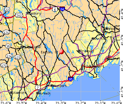
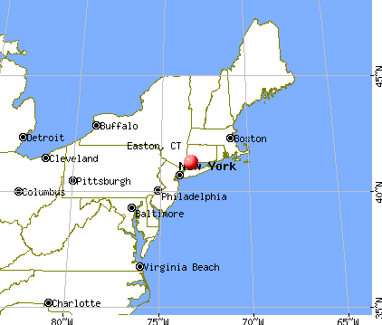
Easton, Connecticut
Submit your own pictures of this town and show them to the world
- OSM Map
- General Map
- Google Map
- MSN Map
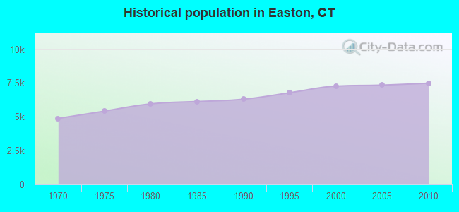
Population change since 2000: +3.0%
 |
| Males: 3,714 | |
| Females: 3,776 |
| Median resident age: | 45.1 years |
| Connecticut median age: | 39.2 years |
Zip codes: 06612.
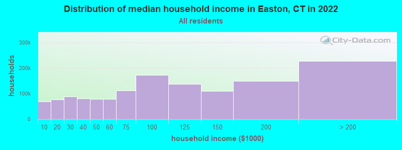
| Easton: | over $200,000 |
| CT: | $88,429 |
Estimated per capita income in 2022: $96,622 (it was $53,885 in 2000)
Easton town income, earnings, and wages data
Estimated median house or condo value in 2022: $991,876 (it was $458,800 in 2000)
| Easton: | $991,876 |
| CT: | $347,200 |
Mean prices in 2022: all housing units: $773,995; detached houses: $872,764; townhouses or other attached units: $449,164; in 2-unit structures: $329,188; in 3-to-4-unit structures: $346,815; in 5-or-more-unit structures: $346,835; mobile homes: $65,227
Detailed information about poverty and poor residents in Easton, CT
Compare current foreclosures near Easton, CT:
| Photo | Address | Area | Beds / Baths | Price | Details |
|---|---|---|---|---|---|

|
#1
Soundview Dr
Easton, CT 06612
|
4,684 sq. feet
|
3 baths 5 beds |
show details | |

|
#2
Buck Hill Rd
Easton, CT 06612
|
3,222 sq. feet
|
3 baths 3 beds |
show details | |

|
#3
Senior Dr
Easton, CT 06612
|
2,156 sq. feet
|
2 baths 3 beds |
show details | |

|
#4
Marsh Rd
Easton, CT 06612
|
1,383 sq. feet
|
1 baths 4 beds |
show details | |

|
#5
Rock House Rd
Easton, CT 06612
|
- sq. feet
|
- baths - beds |
show details | |

|
#6
Santangelo Terrace #30
Derby, CT 06418
|
652 sq. feet
|
1 baths 1 beds |
$189,000
|
show details |

|
#7
Abbott Ave
Danbury, CT 06810
|
1,401 sq. feet
|
1 baths 3 beds |
$499,900
|
show details |

|
#8
Lynne Pl
Bridgeport, CT 06610
|
1,152 sq. feet
|
2 baths 3 beds |
$389,900
|
show details |

|
#9
Davis Dr
Milford, CT 06460
|
1,165 sq. feet
|
1 baths 4 beds |
$454,900
|
show details |

|
#10
N Star Dr
Seymour, CT 06483
|
1,670 sq. feet
|
2 baths 3 beds |
$424,900
|
show details |
| Photo | Address | Area | Beds / Baths | Price | Details |
|---|---|---|---|---|---|

|
#11
Partridge Dr
Seymour, CT 06483
|
1,500 sq. feet
|
1 baths 3 beds |
$300,000
|
show details |

|
#12
Beecher Ave
Shelton, CT 06484
|
1,911 sq. feet
|
2 baths 4 beds |
$589,900
|
show details |

|
#13
Olcott Way # 122
Ridgefield, CT 06877
|
920 sq. feet
|
1 baths 1 beds |
$364,900
|
show details |

|
#14
Highland Park Dr
Danbury, CT 06811
|
875 sq. feet
|
2 baths 2 beds |
$460,000
|
show details |

|
#15
Meadow Brook Rd
Brookfield, CT 06804
|
2,261 sq. feet
|
2 baths 4 beds |
$520,000
|
show details |

|
#16
Sasco Hill Rd
Fairfield, CT 06824
|
- sq. feet
|
5 baths 5 beds |
$6,700,000
|
show details |

|
#17
Lindley St
Bridgeport, CT 06606
|
- sq. feet
|
2 baths 4 beds |
$421,900
|
show details |

|
#18
Kennedy Dr
Bridgeport, CT 06606
|
1,063 sq. feet
|
1 baths 2 beds |
$224,900
|
show details |

|
#19
Talmadge Hill Rd
Darien, CT 06820
|
- sq. feet
|
4 baths 5 beds |
$2,395,000
|
show details |

|
#20
82 Herkimer St
Bridgeport, CT 06604
|
- sq. feet
|
3 baths 5 beds |
show details |
| Photo | Address | Area | Beds / Baths | Price | Details |
|---|---|---|---|---|---|

|
#21
Polk St
Bridgeport, CT 06606
|
1,280 sq. feet
|
1 baths 3 beds |
show details | |

|
#22
Governors Hill Rd
Oxford, CT 06478
|
2,106 sq. feet
|
2 baths 3 beds |
show details | |

|
#23
Mountain View Dr
Weston, CT 06883
|
4,687 sq. feet
|
3 baths 4 beds |
show details | |

|
#24
Riverdale Rd
Milford, CT 06460
|
912 sq. feet
|
1 baths 3 beds |
show details | |

|
#25
Park Ave Unit 22
Bridgeport, CT 06604
|
2,296 sq. feet
|
2 baths 2 beds |
show details | |

|
#26
Great Plain Road15
Danbury, CT 06811
|
715 sq. feet
|
1 baths 1 beds |
show details | |

|
#27
Dover St
Bridgeport, CT 06610
|
982 sq. feet
|
1 baths 2 beds |
show details | |

|
#28
Daniel Ct
Westport, CT 06880
|
4,566 sq. feet
|
4 baths 4 beds |
show details | |

|
#29
Upland Ct
Norwalk, CT 06854
|
1,368 sq. feet
|
1 baths 4 beds |
show details | |

|
#30
Elm St
Monroe, CT 06468
|
2,450 sq. feet
|
2 baths 3 beds |
show details |
| Photo | Address | Area | Beds / Baths | Price | Details |
|---|---|---|---|---|---|

|
#31
Allencrest Dr
Stratford, CT 06614
|
1,884 sq. feet
|
2 baths 4 beds |
show details | |

|
#32
Rennell St
Bridgeport, CT 06604
|
1,419 sq. feet
|
1 baths 3 beds |
show details | |

|
#33
-337 Ridgefield Ave
Bridgeport, CT 06610
|
3,679 sq. feet
|
3 baths 6 beds |
show details | |

|
#34
Buttery Rd
New Canaan, CT 06840
|
1,986 sq. feet
|
2 baths 4 beds |
show details | |

|
#35
Hawthorne Ave
Derby, CT 06418
|
5,129 sq. feet
|
5 baths 7 beds |
show details | |

|
#36
Wooster St
Bethel, CT 06801
|
2,573 sq. feet
|
3 baths 5 beds |
show details | |

|
#37
Huntington Ct
Bethel, CT 06801
|
1,312 sq. feet
|
1 baths 2 beds |
show details | |

|
#38
High View Dr
Stratford, CT 06614
|
2,574 sq. feet
|
2 baths 4 beds |
show details | |

|
#39
Wood Acres Lane
Monroe, CT 06468
|
3,159 sq. feet
|
4 baths 4 beds |
show details | |

|
#40
Beechwood Ave
Bridgeport, CT 06604
|
2,167 sq. feet
|
2 baths 3 beds |
show details |
| Photo | Address | Area | Beds / Baths | Price | Details |
|---|---|---|---|---|---|

|
#41
Madison Ave
Bridgeport, CT 06606
|
1,100 sq. feet
|
1 baths 3 beds |
show details | |

|
#42
Forest Hills Rd
West Haven, CT 06516
|
1,638 sq. feet
|
1 baths 3 beds |
show details | |

|
#43
Horseshoe Dr
Trumbull, CT 06611
|
2,546 sq. feet
|
2 baths 4 beds |
show details | |

|
#44
Lockwood Rd
Fairfield, CT 06825
|
3,635 sq. feet
|
2 baths 5 beds |
show details | |

|
#45
Arden Rd
Trumbull, CT 06611
|
1,767 sq. feet
|
2 baths 3 beds |
show details | |

|
#46
Seymour Rd
Woodbridge, CT 06525
|
2,201 sq. feet
|
2 baths 4 beds |
show details | |

|
#47
Overlook Ave
Bridgeport, CT 06606
|
1,232 sq. feet
|
2 baths 3 beds |
show details | |

|
#48
Linwood St
West Haven, CT 06516
|
1,387 sq. feet
|
1 baths 2 beds |
show details | |

|
#49
Eastwood Rd
Bridgeport, CT 06606
|
1,034 sq. feet
|
2 baths 3 beds |
show details | |

|
Check over 1 million property listings on Foreclosure.com!
|
browse all offers | |||

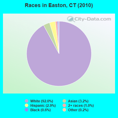
- 6,89292.0%White alone
- 2383.2%Asian alone
- 2202.9%Hispanic
- 761.0%Two or more races
- 460.6%Black alone
- 130.2%Other race alone
- 30.04%American Indian alone
- 20.03%Native Hawaiian and Other
Pacific Islander alone
Races in Easton detailed stats: ancestries, foreign born residents, place of birth
According to our research of Connecticut and other state lists, there were 4 registered sex offenders living in Easton, Connecticut as of May 09, 2024.
The ratio of all residents to sex offenders in Easton is 1,873 to 1.
The ratio of registered sex offenders to all residents in this city is much lower than the state average.
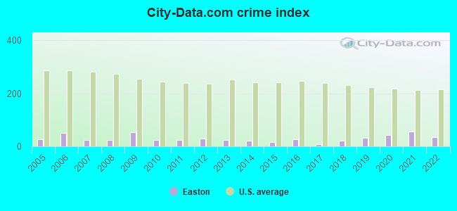
Type |
2009 |
2010 |
2011 |
2012 |
2013 |
2014 |
2015 |
2016 |
2017 |
2018 |
2019 |
2020 |
2021 |
2022 |
|---|---|---|---|---|---|---|---|---|---|---|---|---|---|---|
| Murders (per 100,000) | 0 (0.0) | 0 (0.0) | 0 (0.0) | 0 (0.0) | 0 (0.0) | 0 (0.0) | 0 (0.0) | 0 (0.0) | 0 (0.0) | 0 (0.0) | 0 (0.0) | 0 (0.0) | 0 (0.0) | 0 (0.0) |
| Rapes (per 100,000) | 0 (0.0) | 0 (0.0) | 0 (0.0) | 0 (0.0) | 0 (0.0) | 0 (0.0) | 0 (0.0) | 0 (0.0) | 0 (0.0) | 0 (0.0) | 0 (0.0) | 0 (0.0) | 0 (0.0) | 0 (0.0) |
| Robberies (per 100,000) | 0 (0.0) | 0 (0.0) | 0 (0.0) | 0 (0.0) | 0 (0.0) | 0 (0.0) | 0 (0.0) | 0 (0.0) | 0 (0.0) | 1 (13.2) | 0 (0.0) | 0 (0.0) | 0 (0.0) | 0 (0.0) |
| Assaults (per 100,000) | 2 (27.2) | 0 (0.0) | 4 (53.3) | 0 (0.0) | 1 (13.1) | 0 (0.0) | 0 (0.0) | 1 (13.1) | 0 (0.0) | 0 (0.0) | 0 (0.0) | 0 (0.0) | 0 (0.0) | 0 (0.0) |
| Burglaries (per 100,000) | 28 (381.3) | 15 (200.3) | 3 (40.0) | 17 (224.2) | 15 (196.4) | 10 (130.8) | 8 (104.4) | 7 (91.5) | 3 (39.6) | 2 (26.4) | 13 (172.9) | 5 (66.5) | 4 (53.6) | 4 (52.5) |
| Thefts (per 100,000) | 32 (435.7) | 20 (267.0) | 19 (253.2) | 22 (290.1) | 14 (183.3) | 21 (274.7) | 16 (208.8) | 33 (431.4) | 6 (79.3) | 24 (316.2) | 21 (279.3) | 58 (771.1) | 65 (871.1) | 46 (604.2) |
| Auto thefts (per 100,000) | 3 (40.8) | 0 (0.0) | 1 (13.3) | 1 (13.2) | 1 (13.1) | 0 (0.0) | 0 (0.0) | 0 (0.0) | 1 (13.2) | 3 (39.5) | 8 (106.4) | 7 (93.1) | 15 (201.0) | 6 (78.8) |
| Arson (per 100,000) | 0 (0.0) | 0 (0.0) | 3 (40.0) | 0 (0.0) | 0 (0.0) | 0 (0.0) | 0 (0.0) | 0 (0.0) | 0 (0.0) | 0 (0.0) | 0 (0.0) | 0 (0.0) | 0 (0.0) | 0 (0.0) |
| City-Data.com crime index | 52.8 | 24.7 | 24.7 | 28.3 | 24.8 | 20.1 | 15.7 | 26.3 | 7.0 | 21.6 | 31.8 | 42.9 | 54.7 | 34.2 |
The City-Data.com crime index weighs serious crimes and violent crimes more heavily. Higher means more crime, U.S. average is 246.1. It adjusts for the number of visitors and daily workers commuting into cities.
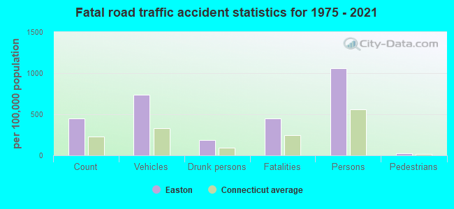
Crime rate in Easton detailed stats: murders, rapes, robberies, assaults, burglaries, thefts, arson
Full-time law enforcement employees in 2021, including police officers: 19 (14 officers - 13 male; 1 female).
| Officers per 1,000 residents here: | 1.88 |
| Connecticut average: | 2.10 |
 Recent articles from our blog. Our writers, many of them Ph.D. graduates or candidates, create easy-to-read articles on a wide variety of topics.

Latest news from Easton, CT collected exclusively by city-data.com from local newspapers, TV, and radio stations
Easton, CT City Guides:
Ancestries: Italian (22.5%), Irish (18.2%), English (12.8%), German (12.1%), Polish (7.3%), United States (4.9%).
Current Local Time: EST time zone
Incorporated on 05/1845
Elevation: 393 feet
Land area: 27.4 square miles.
Population density: 273 people per square mile (very low).
737 residents are foreign born (7.0% Europe, 1.7% Asia).
| This town: | 10.1% |
| Connecticut: | 10.9% |
| Easton town: | 1.3% ($5,866) |
| Connecticut: | 1.8% ($2,961) |
Nearest city with pop. 50,000+: Fairfield, CT  (6.0 miles , pop. 57,340).
Nearest city with pop. 200,000+: North Hempstead, NY (38.4 miles , pop. 222,611).
Nearest city with pop. 1,000,000+: Bronx, NY (41.5 miles , pop. 1,332,650).
Nearest cities:
), ), Latitude: 41.25 N, Longitude: 73.29 W
Area code commonly used in this area: 203

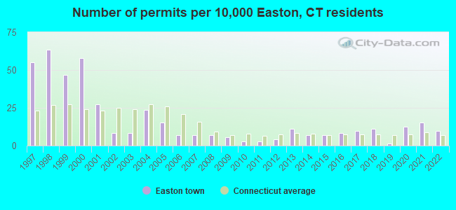
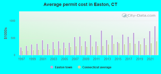
Single-family new house construction building permits:
- 2022: 7 buildings, average cost: $850,000
- 2021: 11 buildings, average cost: $702,600
- 2020: 9 buildings, average cost: $498,700
- 2019: 1 building, cost: $418,700
- 2018: 8 buildings, average cost: $654,500
- 2017: 7 buildings, average cost: $539,700
- 2016: 6 buildings, average cost: $603,600
- 2015: 5 buildings, average cost: $391,000
- 2014: 5 buildings, average cost: $581,800
- 2013: 8 buildings, average cost: $448,300
- 2012: 3 buildings, average cost: $723,100
- 2011: 2 buildings, average cost: $401,000
- 2010: 2 buildings, average cost: $590,800
- 2009: 4 buildings, average cost: $412,600
- 2008: 5 buildings, average cost: $549,700
- 2007: 5 buildings, average cost: $535,400
- 2006: 5 buildings, average cost: $369,300
- 2005: 11 buildings, average cost: $375,600
- 2004: 17 buildings, average cost: $414,000
- 2003: 6 buildings, average cost: $391,000
- 2002: 6 buildings, average cost: $327,600
- 2001: 20 buildings, average cost: $437,800
- 2000: 42 buildings, average cost: $341,300
- 1999: 34 buildings, average cost: $320,300
- 1998: 46 buildings, average cost: $270,900
- 1997: 40 buildings, average cost: $232,100
| Here: | 3.1% |
| Connecticut: | 3.9% |
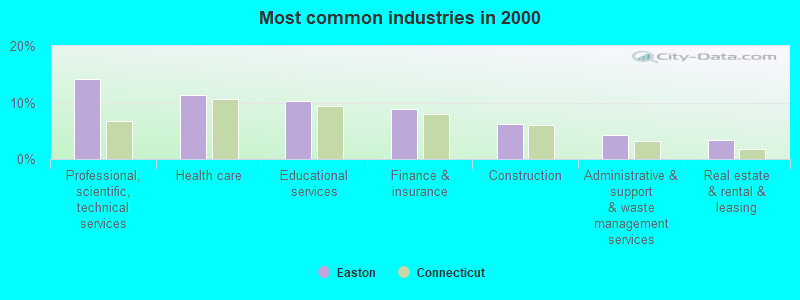
- Professional, scientific, technical services (14.1%)
- Health care (11.3%)
- Educational services (10.2%)
- Finance & insurance (8.8%)
- Construction (6.1%)
- Administrative & support & waste management services (4.3%)
- Real estate & rental & leasing (3.4%)
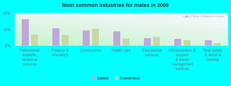
- Professional, scientific, technical services (16.4%)
- Finance & insurance (10.9%)
- Construction (9.5%)
- Health care (9.1%)
- Educational services (4.8%)
- Administrative & support & waste management services (4.5%)
- Real estate & rental & leasing (3.5%)
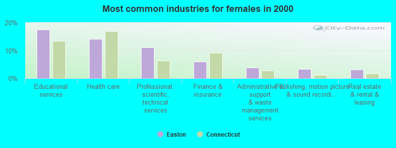
- Educational services (17.4%)
- Health care (14.2%)
- Professional, scientific, technical services (11.2%)
- Finance & insurance (6.1%)
- Administrative & support & waste management services (4.0%)
- Publishing, motion picture & sound recording industries (3.4%)
- Real estate & rental & leasing (3.2%)
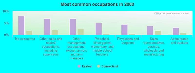
- Top executives (8.2%)
- Other sales and related occupations, including supervisors (6.9%)
- Other management occupations, except farmers and farm managers (6.9%)
- Preschool, kindergarten, elementary, and middle school teachers (5.0%)
- Physicians and surgeons (4.4%)
- Sales representatives, services, wholesale and manufacturing (3.9%)
- Accountants and auditors (3.1%)
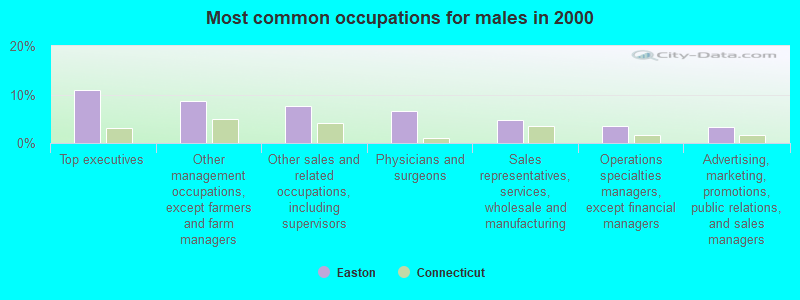
- Top executives (10.9%)
- Other management occupations, except farmers and farm managers (8.6%)
- Other sales and related occupations, including supervisors (7.5%)
- Physicians and surgeons (6.6%)
- Sales representatives, services, wholesale and manufacturing (4.8%)
- Operations specialties managers, except financial managers (3.4%)
- Advertising, marketing, promotions, public relations, and sales managers (3.3%)
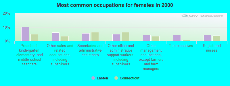
- Preschool, kindergarten, elementary, and middle school teachers (10.4%)
- Other sales and related occupations, including supervisors (6.1%)
- Secretaries and administrative assistants (5.7%)
- Other office and administrative support workers, including supervisors (5.0%)
- Other management occupations, except farmers and farm managers (4.6%)
- Top executives (4.6%)
- Registered nurses (4.2%)
Average climate in Easton, Connecticut
Based on data reported by over 4,000 weather stations


(lower is better)
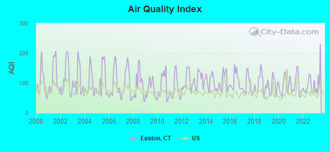
Air Quality Index (AQI) level in 2022 was 88.6. This is worse than average.
| City: | 88.6 |
| U.S.: | 72.6 |
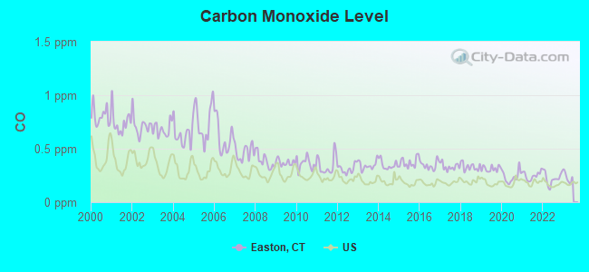
Carbon Monoxide (CO) [ppm] level in 2022 was 0.223. This is about average. Closest monitor was 7.4 miles away from the city center.
| City: | 0.223 |
| U.S.: | 0.251 |
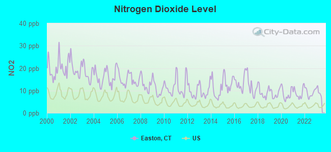
Nitrogen Dioxide (NO2) [ppb] level in 2022 was 9.00. This is significantly worse than average. Closest monitor was 7.1 miles away from the city center.
| City: | 9.00 |
| U.S.: | 5.11 |
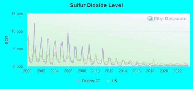
Sulfur Dioxide (SO2) [ppb] level in 2022 was 0.220. This is significantly better than average. Closest monitor was 7.1 miles away from the city center.
| City: | 0.220 |
| U.S.: | 1.515 |
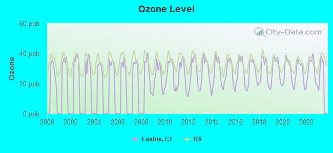
Ozone [ppb] level in 2022 was 29.0. This is about average. Closest monitor was 7.1 miles away from the city center.
| City: | 29.0 |
| U.S.: | 33.3 |
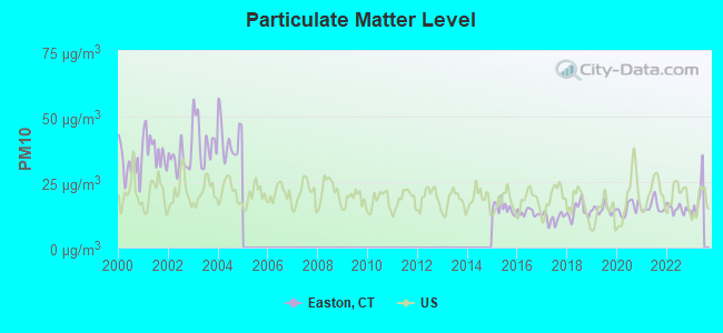
Particulate Matter (PM10) [µg/m3] level in 2022 was 14.7. This is better than average. Closest monitor was 7.1 miles away from the city center.
| City: | 14.7 |
| U.S.: | 19.2 |
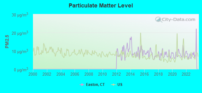
Particulate Matter (PM2.5) [µg/m3] level in 2022 was 7.55. This is about average. Closest monitor was 7.1 miles away from the city center.
| City: | 7.55 |
| U.S.: | 8.11 |
Tornado activity:
Easton-area historical tornado activity is near Connecticut state average. It is 37% smaller than the overall U.S. average.
On 7/10/1989, a category F4 (max. wind speeds 207-260 mph) tornado 19.7 miles away from the Easton town center injured 40 people and caused between $50,000,000 and $500,000,000 in damages.
On 5/24/1962, a category F3 (max. wind speeds 158-206 mph) tornado 22.3 miles away from the town center killed one person and injured 50 people and caused between $500,000 and $5,000,000 in damages.
Earthquake activity:
Easton-area historical earthquake activity is significantly above Connecticut state average. It is 70% smaller than the overall U.S. average.On 10/7/1983 at 10:18:46, a magnitude 5.3 (5.1 MB, 5.3 LG, 5.1 ML, Class: Moderate, Intensity: VI - VII) earthquake occurred 194.2 miles away from Easton center
On 4/20/2002 at 10:50:47, a magnitude 5.3 (5.3 ML, Depth: 3.0 mi) earthquake occurred 226.3 miles away from the city center
On 4/20/2002 at 10:50:47, a magnitude 5.2 (5.2 MB, 4.2 MS, 5.2 MW, 5.0 MW) earthquake occurred 224.7 miles away from the city center
On 8/23/2011 at 17:51:04, a magnitude 5.8 (5.8 MW, Depth: 3.7 mi) earthquake occurred 338.9 miles away from Easton center
On 1/16/1994 at 01:49:16, a magnitude 4.6 (4.6 MB, 4.6 LG, Depth: 3.1 mi, Class: Light, Intensity: IV - V) earthquake occurred 157.5 miles away from the city center
On 1/19/1982 at 00:14:42, a magnitude 4.7 (4.5 MB, 4.7 MD, 4.5 LG) earthquake occurred 177.7 miles away from Easton center
Magnitude types: regional Lg-wave magnitude (LG), body-wave magnitude (MB), duration magnitude (MD), local magnitude (ML), surface-wave magnitude (MS), moment magnitude (MW)
Natural disasters:
The number of natural disasters in Fairfield County (24) is greater than the US average (15).Major Disasters (Presidential) Declared: 13
Emergencies Declared: 11
Causes of natural disasters: Storms: 6, Floods: 5, Hurricanes: 5, Snowstorms: 4, Blizzards: 3, Snows: 3, Winter Storms: 3, Tropical Storms: 2, Snowfall: 1, Wind: 1 (Note: some incidents may be assigned to more than one category).

Hospitals and medical centers near Easton:
- JEWISH HM FOR THE ELDERLY FAIR (Nursing Home, about 3 miles away; FAIRFIELD, CT)
- LUDLOWE CENTER FOR HEALTH AND REHABILITATION, LLC (Nursing Home, about 3 miles away; FAIRFIELD, CT)
- JEWISH HOME CARE AGENCY (Home Health Center, about 4 miles away; FAIRFIELD, CT)
- ST JOSEPH'S MANOR CARE AND REHABILITATION CENTER (Nursing Home, about 4 miles away; TRUMBULL, CT)
- CONN HOME HEALTH CARE INC (Home Health Center, about 5 miles away; TRUMBULL, CT)
- GENTIVA HEALTH SERVICES (Home Health Center, about 5 miles away; TRUMBULL, CT)
- UNITED VISITING NURSE ASSOCIAI (Hospital, about 5 miles away; TRUMBULL, CT)
Amtrak stations near Easton:
- 8 miles: BRIDGEPORT (525 WATER ST.) . Services: fully wheelchair accessible, enclosed waiting area, public restrooms, public payphones, snack bar, paid short-term parking, paid long-term parking, call for car rental service, taxi stand, intercity bus service, public transit connection.
- 20 miles: NEW HAVEN (50 UNION AVE.) . Services: ticket office, partially wheelchair accessible, enclosed waiting area, public restrooms, public payphones, snack bar, ATM, paid short-term parking, paid long-term parking, car rental agency, taxi stand, intercity bus service, public transit connection.
- 20 miles: STAMFORD (WASHINGTON BLVD. & E. STATE ST.) . Services: ticket office, fully wheelchair accessible, enclosed waiting area, public restrooms, public payphones, snack bar, ATM, paid short-term parking, paid long-term parking, call for car rental service, taxi stand, public transit connection.
Colleges/universities with over 2000 students nearest to Easton:
- Sacred Heart University (about 4 miles; Fairfield, CT; Full-time enrollment: 5,650)
- Fairfield University (about 7 miles; Fairfield, CT; FT enrollment: 4,640)
- Housatonic Community College (about 8 miles; Bridgeport, CT; FT enrollment: 3,677)
- University of Bridgeport (about 8 miles; Bridgeport, CT; FT enrollment: 3,708)
- Porter and Chester Institute of Stratford (about 10 miles; Stratford, CT; FT enrollment: 2,822)
- Western Connecticut State University (about 13 miles; Danbury, CT; FT enrollment: 5,345)
- Norwalk Community College (about 14 miles; Norwalk, CT; FT enrollment: 4,085)
Private high school in Easton:
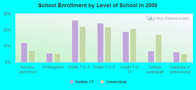
Public elementary/middle schools in Easton:
- SAMUEL STAPLES ELEMENTARY SCHOOL (Students: 782, Location: 515 MOREHOUSE ROAD, Grades: PK-5)
- HELEN KELLER MIDDLE SCHOOL (Students: 374, Location: 360 SPORT HILL ROAD, Grades: 6-8)
User-submitted facts and corrections:
- There is no high school in Easton, CT. Students attend a regional high school shared with Redding, CT located in Redding on Route 58/Black Rock Turnpike, Joel Barlow High School
added by Joel Barlow Graduate
- Bridgeport Hospital is one of the two hospitals serving this region - about 10 miles.Stamford Hospital is much more than 6 miles; Norwalk Hospital is closer. Hal Brooke is rehab. center.
- You may wish to investigate further, but recent article in FORBES on Rolling Stones has Keith Richards with a home in Easton. added by Glimmer Twin
- There is no high school in Easton. Easton shares a high school called Joel Barlow High School which is located in Redding CT. Remove \"homebound\" as a school in Easton.
- Bridgeport Hospital is one of the two hospitals serving this region - about 10 miles.Stamford Hospital is much more than 6 miles; Norwalk Hospital is closer. Hal Brooke is rehab. center.
Points of interest:
Notable locations in Easton: Twin Bridges (A), Connecticut Golf Club (B), Aspetuck Four Corners (C), Easton Volunteer Emergency Management Service (D), Easton Volunteer Fire Department (E). Display/hide their locations on the map
Churches in Easton include: Covenant Church of Easton (A), Easton Baptist Church (B), Christ Church (C), Jesse Lee United Methodist Church (D), Notre Dame of Easton (E). Display/hide their locations on the map
Cemeteries: Gilbertown Cemetery (1), Union Cemetery (2), Aspetuck Cemetery (3), Old Indian Cemetery (4), Maple Grove Memorial Park (5). Display/hide their locations on the map
Lakes and reservoirs: Kachele Pond (A), Livermore Pond (B), Mother Superior Lake (C), Pfeiffer Pond (D), Big Lake (E), Aspetuck Reservoir (F), Hemlock Reservoir (G), Easton Reservoir (H). Display/hide their locations on the map
Streams, rivers, and creeks: Patterson Brook (A), Ballwall Brook (B), Canoe Brook (C), Chub Brook (D), Gilbert Brook (E), Tatetuck Brook (F). Display/hide their locations on the map
Park in Easton: Senoir Park (1). Display/hide its location on the map
Tourist attraction: Historical Society of Easton (Museums; 691 Morehouse Road) (1). Display/hide its approximate location on the map
Birthplace of: Ellen Stagg - Photographer.
| This town: | 2.9 people |
| Connecticut: | 2.5 people |
| This town: | 81.7% |
| Whole state: | 66.3% |
| This town: | 2.9% |
| Whole state: | 6.6% |
Likely homosexual households (counted as self-reported same-sex unmarried-partner households)
- Lesbian couples: 0.2% of all households
- Gay men: 0.3% of all households
| This town: | 2.4% |
| Whole state: | 7.9% |
| This town: | 1.1% |
| Whole state: | 3.9% |
For population 15 years and over in Easton:
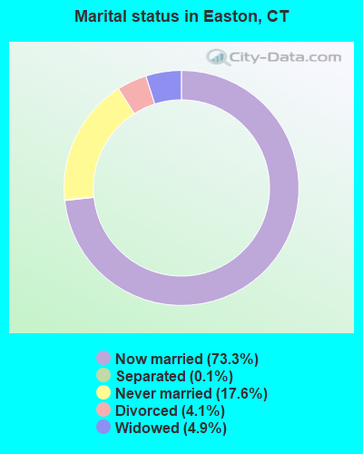
- Never married: 17.6%
- Now married: 73.3%
- Separated: 0.1%
- Widowed: 4.9%
- Divorced: 4.1%
For population 25 years and over in Easton:
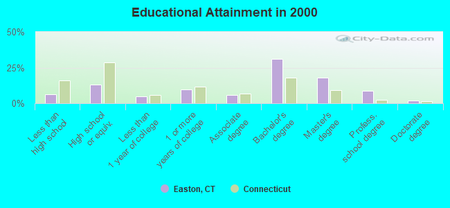
- High school or higher: 93.8%
- Bachelor's degree or higher: 59.5%
- Graduate or professional degree: 28.6%
- Unemployed: 2.3%
- Mean travel time to work (commute): 34.8 minutes
| Here: | 10.9 |
| Connecticut average: | 12.8 |
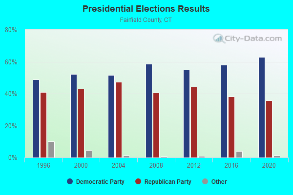
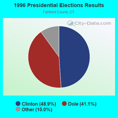
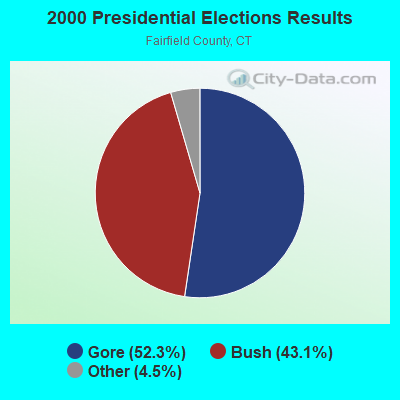
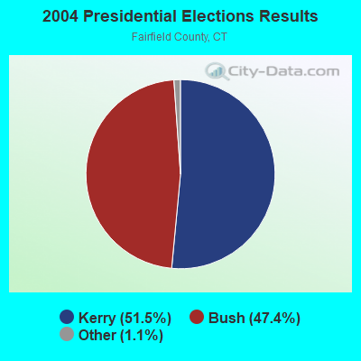
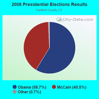
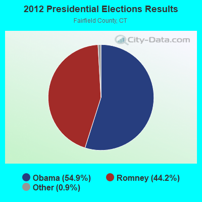
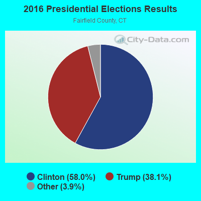
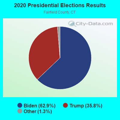
Graphs represent county-level data. Detailed 2008 Election Results
Religion statistics for Easton, CT (based on Fairfield County data)
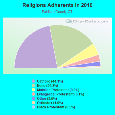
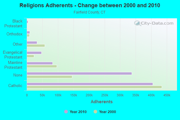
| Religion | Adherents | Congregations |
|---|---|---|
| Catholic | 404,341 | 94 |
| Mainline Protestant | 82,604 | 175 |
| Evangelical Protestant | 46,888 | 242 |
| Other | 32,501 | 95 |
| Orthodox | 9,215 | 21 |
| Black Protestant | 4,144 | 27 |
| None | 337,136 | - |
Food Environment Statistics:
| This county: | 2.50 / 10,000 pop. |
| Connecticut: | 2.21 / 10,000 pop. |
| Fairfield County: | 0.06 / 10,000 pop. |
| Connecticut: | 0.07 / 10,000 pop. |
| Fairfield County: | 0.85 / 10,000 pop. |
| Connecticut: | 1.02 / 10,000 pop. |
| Here: | 1.70 / 10,000 pop. |
| Connecticut: | 2.27 / 10,000 pop. |
| This county: | 9.67 / 10,000 pop. |
| Connecticut: | 9.19 / 10,000 pop. |
| Fairfield County: | 6.5% |
| Connecticut: | 7.3% |
| Fairfield County: | 17.9% |
| Connecticut: | 21.5% |
| This county: | 17.2% |
| Connecticut: | 15.8% |
5.92% of this county's 2021 resident taxpayers lived in other counties in 2020 ($194,373 average adjusted gross income)
| Here: | 5.92% |
| Connecticut average: | 5.79% |
0.01% of residents moved from foreign countries ($50 average AGI)
Fairfield County: 0.01% Connecticut average: 0.02%
Top counties from which taxpayers relocated into this county between 2020 and 2021:
| from Westchester County, NY | |
| from New York County, NY | |
| from New Haven County, CT |
6.13% of this county's 2020 resident taxpayers moved to other counties in 2021 ($174,109 average adjusted gross income)
| Here: | 6.13% |
| Connecticut average: | 5.82% |
0.01% of residents moved to foreign countries ($428 average AGI)
Fairfield County: 0.01% Connecticut average: 0.02%
Top counties to which taxpayers relocated from this county between 2020 and 2021:
| to New Haven County, CT | |
| to New York County, NY | |
| to Westchester County, NY |
Strongest AM radio stations in Easton:
- WDJZ (1530 AM; daytime; 5 kW; BRIDGEPORT, CT; Owner: PEOPLE'S BROADCAST NETWORK, LLC)
- WFAN (660 AM; 50 kW; NEW YORK, NY; Owner: INFINITY BROADCASTING OPERATIONS, INC.)
- WCBS (880 AM; 50 kW; NEW YORK, NY; Owner: INFINITY BROADCASTING OPERATIONS, INC.)
- WGSM (740 AM; 25 kW; HUNTINGTON, NY; Owner: K RADIO LICENSEE, INC.)
- WADS (690 AM; daytime; 3 kW; ANSONIA, CT; Owner: RADIO AMOR, INC.)
- WFIF (1500 AM; daytime; 5 kW; MILFORD, CT)
- WCUM (1450 AM; 1 kW; BRIDGEPORT, CT; Owner: RADIO CUMBRE BROADCASTING, INC.)
- WMCA (570 AM; 50 kW; NEW YORK, NY; Owner: SALEM MEDIA OF NEW YORK, LLC)
- WABC (770 AM; 50 kW; NEW YORK, NY; Owner: WABC-AM RADIO, INC.)
- WREF (850 AM; 2 kW; RIDGEFIELD, CT; Owner: THE BERKSHIRE BROADCASTING CORP.)
- WOR (710 AM; 50 kW; NEW YORK, NY; Owner: BUCKLEY BROADCASTING CORPORATION)
- WTIC (1080 AM; 50 kW; HARTFORD, CT; Owner: INFINITY RADIO OPERATIONS INC.)
- WICC (600 AM; 1 kW; BRIDGEPORT, CT; Owner: CUMULUS LICENSING CORP.)
Strongest FM radio stations in Easton:
- WEZN-FM (99.9 FM; BRIDGEPORT, CT; Owner: CXR HOLDINGS, INC.)
- WSHU-FM (91.1 FM; FAIRFIELD, CT; Owner: SACRED HEART UNIVERSITY, INC.)
- WPKN (89.5 FM; BRIDGEPORT, CT; Owner: WPKN, INC.)
- WMNR (88.1 FM; MONROE, CT; Owner: MONROE BOARD OF EDUCATION)
- WEBE (107.9 FM; WESTPORT, CT; Owner: CUMULUS LICENSING CORP.)
- WMNR-FM1 (88.1 FM; HUNTINGTON, CT; Owner: MONROE BOARD OF EDUCATION)
- WDAQ (98.3 FM; DANBURY, CT; Owner: BERKSHIRE BROADCASTING CORP.)
- W285DE (104.9 FM; BRIDGEPORT, CT; Owner: DANBURY COMMUNITY RADIO, INC.)
- WRXC (90.1 FM; SHELTON, CT; Owner: MONROE BOARD OF EDUCATION)
- WKCI-FM (101.3 FM; HAMDEN, CT; Owner: CLEAR CHANNEL BROADCASTING LICENSES, INC.)
- WPLR (99.1 FM; NEW HAVEN, CT; Owner: COX RADIO, INC.)
- W220CF (91.9 FM; HUNTINGTON, CT; Owner: MONROE BOARD OF EDUCATION)
- WRKI (95.1 FM; BROOKFIELD, CT; Owner: CUMULUS LICENSING CORP.)
- WWPT (90.3 FM; WESTPORT, CT; Owner: WESTPORT CT. BOARD OF EDUCATION)
- WYBC-FM (94.3 FM; NEW HAVEN, CT; Owner: YALE BROADCASTING CO., INC.)
- WEFX (95.9 FM; NORWALK, CT; Owner: COX RADIO, INC.)
- WALK-FM (97.5 FM; PATCHOGUE, NY; Owner: AMFM RADIO LICENSES, L.L.C.)
- WPLJ (95.5 FM; NEW YORK, NY; Owner: WPLJ-FM RADIO, INC.)
- WFAF (106.3 FM; MOUNT KISCO, NY; Owner: CUMULUS LICENSING CORP.)
- WSPK (104.7 FM; POUGHKEEPSIE, NY; Owner: 6 JOHNSON ROAD LICENSES, INC.)
TV broadcast stations around Easton:
- WEDW (Channel 49; BRIDGEPORT, CT; Owner: CONNECTICUT PUBLIC BROADCASTING, INC.)
- WTNH (Channel 8; NEW HAVEN, CT; Owner: WTNH BROADCASTING, INC.)
- WEDY (Channel 65; NEW HAVEN, CT; Owner: CONNECTICUT PUBLIC BROADCASTING, INC.)
- WCTX (Channel 59; NEW HAVEN, CT; Owner: WTNH BROADCASTING, INC.)
- WTIC-TV (Channel 61; HARTFORD, CT; Owner: TRIBUNE TELEVISION COMPANY)
- W11BJ (Channel 11; HARTFORD, CT; Owner: COMMUNICATIONS SITE MANAGEMENT LLC)
- WNYW (Channel 5; NEW YORK, NY; Owner: FOX TELEVISION STATIONS, INC.)
- WSAH (Channel 43; BRIDGEPORT, CT; Owner: WSAH LICENSE, INC.)
- WCBS-TV (Channel 2; NEW YORK, NY; Owner: CBS BROADCASTING INC.)
- WTXX (Channel 20; WATERBURY, CT; Owner: WTXX INC.)
- WABC-TV (Channel 7; NEW YORK, NY; Owner: AMERICAN BROADCASTING COMPANIES, INC)
- WPIX (Channel 11; NEW YORK, NY; Owner: WPIX, INC.)
- WWOR-TV (Channel 9; SECAUCUS, NJ; Owner: FOX TELEVISION STATIONS, INC.)
- WVIT (Channel 30; NEW BRITAIN, CT; Owner: OUTLET BROADCASTING, INC)
- WNJU (Channel 47; LINDEN, NJ; Owner: WNJU LICENSE CORPORATION)
- WEDH (Channel 24; HARTFORD, CT; Owner: CONNECTICUT PUBLIC BROADCASTING, INC.)
- WXNY-LP (Channel 32; NEW YORK, NY; Owner: ISLAND BROADCASTING COMPANY)
- WPXN-TV (Channel 31; NEW YORK, NY; Owner: PAXSON COMMUNICATIONS LICENSE COMPANY, LLC)
- WFUT (Channel 68; NEWARK, NJ; Owner: UNIVISION NEW YORK LLC)
- WNBC (Channel 4; NEW YORK, NY; Owner: NATIONAL BROADCASTING COMPANY, INC.)
- WNET (Channel 13; NEWARK, NJ; Owner: EDUCATIONAL BROADCASTING CORPORATION)
- WXTV (Channel 41; PATERSON, NJ; Owner: WXTV LICENSE PARTNERSHIP, G.P.)
- WNYE-TV (Channel 25; NEW YORK, NY; Owner: NEW YORK CITY BOARD OF EDUCATION)
- WUVN (Channel 18; HARTFORD, CT; Owner: ENTRAVISION HOLDINGS, LLC)
- W65DZ (Channel 65; BRIDGEPORT, CT; Owner: PAGING ASSOCIATES, INC.)
- National Bridge Inventory (NBI) Statistics
- 7Number of bridges
- 33ft / 9.8mTotal length
- 19,100Total average daily traffic
- 978Total average daily truck traffic
- 28,381Total future (year 2038) average daily traffic
FCC Registered Antenna Towers:
10 (See the full list of FCC Registered Antenna Towers in Easton)FCC Registered Commercial Land Mobile Towers:
1 (See the full list of FCC Registered Commercial Land Mobile Towers in Easton, CT)FCC Registered Private Land Mobile Towers:
4 (See the full list of FCC Registered Private Land Mobile Towers)FCC Registered Broadcast Land Mobile Towers:
8 (See the full list of FCC Registered Broadcast Land Mobile Towers)FCC Registered Microwave Towers:
2- EASTON POLICE, 700 Morehouse Road (Lat: 41.254417 Lon: -73.298333), Type: Building, Structure height: 6.1 m, Call Sign: WPUB477,
Assigned Frequencies: 959.150 MHz, Grant Date: 01/29/2002, Expiration Date: 01/29/2012, Cancellation Date: 03/31/2012, Certifier: John Solomon, Registrant: New England Communications Syst, Inc, 15 Industrial Park Place, Middletown, CT 06457, Phone: (860) 632-2678, Fax: (860) 613-0827
- EASTON ELEMENTARY, 660 Morehouse Road (Lat: 41.253000 Lon: -73.297500), Type: Building, Structure height: 6.1 m, Call Sign: WPUB582,
Assigned Frequencies: 955.550 MHz, Grant Date: 01/30/2002, Expiration Date: 01/30/2012, Cancellation Date: 03/31/2012, Certifier: John Solomon, Registrant: New England Communications Syst, Inc, 15 Industrial Park Place, Middletown, CT 06457, Phone: (860) 632-2678, Fax: (860) 613-0827
FCC Registered Paging Towers:
3- Route 59 At Silverman Farm (Lat: 41.251472 Lon: -73.283167), Call Sign: KNKE863,
Assigned Frequencies: 931.687 MHz, 931.687 MHz, Grant Date: 04/19/1999, Expiration Date: 04/01/2009, Cancellation Date: 08/07/2001, Certifier: Name On File, Registrant: Wilkinson, Barker, Knauer LLP, 2300 N Street N. W., Suite 700, Washinton, DC 20037-1128, Phone: (202) 783-4141, Fax: (202) 783-5851, Email:
- Top Of Round Hill, Rt 59, 2.6 Mi North Of Merritt Exp (Lat: 41.251472 Lon: -73.283167), Call Sign: KNKG616,
Assigned Frequencies: 931.612 MHz, Grant Date: 04/27/1999, Expiration Date: 04/01/2009, Cancellation Date: 01/30/2009, Certifier: Shawn E Endsley, Registrant: Usa Mobility Wireless, Inc., 300 Technology Drive #400, Plano, TX 75074, Phone: (972) 801-1626, Fax: (972) 801-1699, Email:
- Top Of Round Hill, Rt 59, 2.6 Mi N Of Merit Exp. (Lat: 41.251472 Lon: -73.283167), Overall height: 22.6 m, Call Sign: KNKH919,
Assigned Frequencies: 931.062 MHz, Grant Date: 04/27/1999, Expiration Date: 04/01/2009, Cancellation Date: 01/30/2009, Certifier: Shawn E Endsley, Registrant: Usa Mobility Wireless, Inc., 300 Technology Drive #400, Plano, TX 75074, Phone: (972) 801-1626, Fax: (972) 801-1699, Email:
FCC Registered Amateur Radio Licenses:
32 (See the full list of FCC Registered Amateur Radio Licenses in Easton)FAA Registered Aircraft:
9 (See the full list of FAA Registered Aircraft in Easton)2002 - 2018 National Fire Incident Reporting System (NFIRS) incidents
- Fire incident types reported to NFIRS in Easton, CT
- 16844.1%Structure Fires
- 13635.7%Outside Fires
- 4511.8%Mobile Property/Vehicle Fires
- 328.4%Other
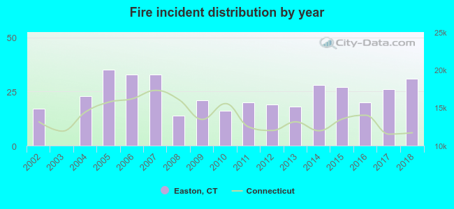 According to the data from the years 2002 - 2018 the average number of fires per year is 22. The highest number of reported fires - 35 took place in 2005, and the least - 0 in 2003. The data has a growing trend.
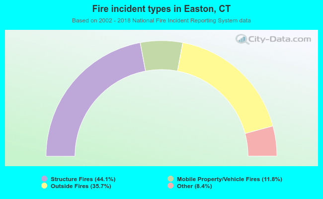 When looking into fire subcategories, the most incidents belonged to: Structure Fires (44.1%), and Outside Fires (35.7%).
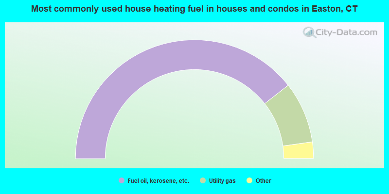
- 78.9%Fuel oil, kerosene, etc.
- 16.7%Utility gas
- 2.2%Electricity
- 2.0%Bottled, tank, or LP gas
- 0.3%Wood
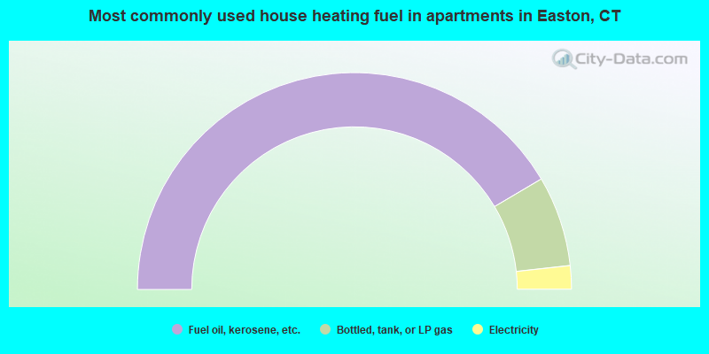
- 83.0%Fuel oil, kerosene, etc.
- 13.5%Bottled, tank, or LP gas
- 3.5%Electricity
Easton compared to Connecticut state average:
- Median household income significantly above state average.
- Median house value significantly above state average.
- Unemployed percentage significantly below state average.
- Black race population percentage significantly below state average.
- Hispanic race population percentage significantly below state average.
- Median age above state average.
- Renting percentage significantly below state average.
- Length of stay since moving in significantly above state average.
- Number of rooms per house significantly below state average.
- House age significantly below state average.
- Percentage of population with a bachelor's degree or higher above state average.
Easton on our top lists:
- #3 on the list of "Top 101 cities with largest percentage of females in occupations: top executives (population 5,000+)"
- #4 on the list of "Top 101 cities with largest percentage of females in occupations: librarians, curators, and archivists (population 5,000+)"
- #8 on the list of "Top 101 cities with largest percentage of females in industries: electronic shopping and mail-order houses (population 5,000+)"
- #9 on the list of "Top 101 cities with largest percentage of males in occupations: physicians and surgeons (population 5,000+)"
- #10 on the list of "Top 101 cities with largest percentage of males in occupations: top executives (population 5,000+)"
- #12 on the list of "Top 101 cities with largest percentage of males in industries: data processing, libraries, and other information services (population 5,000+)"
- #13 on the list of "Top 101 cities with largest percentage of females in occupations: preschool, kindergarten, elementary and middle school teachers (population 5,000+)"
- #15 on the list of "Top 101 cities with largest percentage of males in occupations: social scientists and related workers (population 5,000+)"
- #20 on the list of "Top 101 cities with largest percentage of males in industries: apparel, fabrics, and notions merchant wholesalers (population 5,000+)"
- #22 on the list of "Top 101 cities with the largest percentage of one, detached housing units in structures (2,000+ housing units)"
- #25 on the list of "Top 101 cities with largest percentage of females in industries: publishing, and motion picture and sound recording industries (population 5,000+)"
- #36 on the list of "Top 101 cities with largest percentage of males in industries: health care (population 5,000+)"
- #42 on the list of "Top 100 safest cities (lowest city-data.com crime index) (pop. 5,000+)"
- #53 on the list of "Top 101 cities with largest percentage of females in industries: sewing, needlework, and piece goods stores (population 5,000+)"
- #53 on the list of "Top 101 cities with the lowest number of thefts per 100,000 residents (population 5,000+)"
- #55 on the list of "Top 100 cities with highest median household income (pop. 5,000+)"
- #56 on the list of "Top 101 cities with the lowest city-data.com crime index (population 5,000+)"
- #59 on the list of "Top 101 cities with the smallest city-data.com crime index per police officer (population 5,000+)"
- #60 on the list of "Top 101 cities with the largest city-data.com crime index increase from 2011 to 2012 (population 5,000+)"
- #60 on the list of "Top 101 cities with the lowest number of assaults per 100,000 residents (population 5,000+)"
- #83 (06612) on the list of "Top 101 zip codes with the largest percentage of taxpayers reporting taxable interest in 2012 (pop 5,000+)"
- #90 (06612) on the list of "Top 101 zip codes with the largest percentage of taxpayers using charity contributions deductions in 2012 (pop 5,000+)"
- #101 (06612) on the list of "Top 101 zip codes with the largest percentage of Hungarian first ancestries (pop 5,000+)"
- #14 on the list of "Top 101 counties with the most Orthodox congregations"
- #18 on the list of "Top 101 counties with the best general health status score of residents (1-5), 3 years of data"
- #21 on the list of "Top 101 counties with the most Catholic congregations"
- #21 on the list of "Top 101 counties with the most Catholic adherents"
- #22 on the list of "Top 101 counties with the highest percentage of residents that visited a dentist within the past year"

|
|
Total of 291 patent applications in 2008-2024.