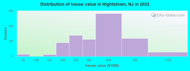
Estimated median house or condo value in 2022: $328,594 (it was $137,300 in 2000)
Hightstown:
$328,594
NJ:
$428,900
Mean prices in 2022:all housing units: $349,725; detached houses: $366,694; townhouses or other attached units: $390,363; in 2-unit structures: $382,947; in 3-to-4-unit structures: $243,957; in 5-or-more-unit structures: $287,426
Median gross rent in 2022: $1,615.
March 2022 cost of living index in Hightstown: 112.7 (more than average, U.S. average is 100)
Percentage of residents living in poverty in 2022: 1.4%
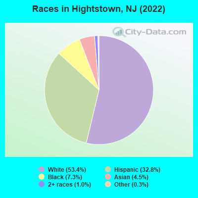
(1.7% for White Non-Hispanic residents, 2.8% for Black residents, 0.7% for Hispanic or Latino residents, 8.7% for two or more races residents)
According to our research of New Jersey and other state lists, there was 1 registered sex offender living in Hightstown, New Jersey as of May 11, 2024. The ratio of all residents to sex offenders in Hightstown is 5,530 to 1. The ratio of registered sex offenders to all residents in this city is much lower than the state average.
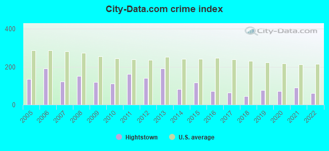
Crime rates in Hightstown by year
Type
2009
2010
2011
2012
2013
2014
2015
2016
2017
2018
2019
2020
2021
2022
Murders (per 100,000)
0 (0.0)
0 (0.0)
0 (0.0)
0 (0.0)
0 (0.0)
0 (0.0)
0 (0.0)
0 (0.0)
0 (0.0)
0 (0.0)
0 (0.0)
0 (0.0)
0 (0.0)
0 (0.0)
Rapes (per 100,000)
2 (37.7)
0 (0.0)
3 (54.4)
3 (54.2)
4 (71.8)
0 (0.0)
2 (35.9)
1 (18.2)
1 (18.1)
1 (18.9)
3 (57.0)
1 (19.0)
3 (54.8)
0 (0.0)
Robberies (per 100,000)
1 (18.9)
6 (109.2)
4 (72.6)
3 (54.2)
2 (35.9)
3 (53.6)
0 (0.0)
4 (72.8)
1 (18.1)
0 (0.0)
1 (19.0)
0 (0.0)
0 (0.0)
2 (34.1)
Assaults (per 100,000)
5 (94.3)
3 (54.6)
6 (108.9)
5 (90.4)
4 (71.8)
4 (71.5)
12 (215.3)
1 (18.2)
3 (54.3)
0 (0.0)
2 (38.0)
9 (170.7)
8 (146.2)
5 (85.3)
Burglaries (per 100,000)
21 (396.0)
25 (455.0)
16 (290.3)
16 (289.2)
27 (484.6)
13 (232.5)
8 (143.5)
3 (54.6)
8 (144.9)
6 (113.4)
2 (38.0)
1 (19.0)
3 (54.8)
7 (119.5)
Thefts (per 100,000)
47 (886.3)
46 (837.3)
67 (1,216)
60 (1,084)
96 (1,723)
51 (912.0)
45 (807.3)
37 (673.8)
32 (579.5)
28 (529.4)
19 (360.9)
25 (474.1)
15 (274.1)
30 (512.0)
Auto thefts (per 100,000)
1 (18.9)
2 (36.4)
4 (72.6)
0 (0.0)
4 (71.8)
0 (0.0)
1 (17.9)
1 (18.2)
0 (0.0)
0 (0.0)
1 (19.0)
1 (19.0)
2 (36.5)
3 (51.2)
Arson (per 100,000)
0 (0.0)
0 (0.0)
2 (36.3)
0 (0.0)
0 (0.0)
0 (0.0)
0 (0.0)
0 (0.0)
0 (0.0)
0 (0.0)
0 (0.0)
0 (0.0)
0 (0.0)
0 (0.0)
City-Data.com crime index
119.4
111.9
161.8
141.3
191.1
83.2
115.5
72.3
64.1
44.2
77.5
71.1
90.8
60.2
The City-Data.com crime index weighs serious crimes and violent crimes more heavily. Higher means more crime, U.S. average is 246.1. It adjusts for the number of visitors and daily workers commuting into cities.
Latest news from Hightstown, NJ collected exclusively by city-data.com from local newspapers, TV, and radio stations
Ancestries: German (14.1%), Italian (10.1%), Nigerian (5.7%), American (3.7%), Russian (3.5%), Hungarian (2.5%).
Current Local Time: EST time zone
Incorporated in 1853
Elevation: 84 feet
Land area: 1.23 square miles.
Population density: 4,773 people per square mile (average).
1,459 residents are foreign born (16.0% Latin America, 3.0% Asia, 2.8% Europe).
This borough:
25.1%
New Jersey:
23.2%
Median real estate property taxes paid for housing units with mortgages in 2022: $8,042 (2.6%) Median real estate property taxes paid for housing units with no mortgage in 2022: $9,787 (2.7%)
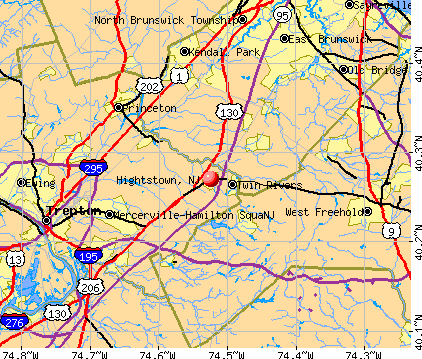
Nearest city with pop. 50,000+: Trenton, NJ (12.7 miles , pop. 85,403).
Nearest city with pop. 200,000+: Staten Island, NY (29.6 miles , pop. 443,728).
Nearest city with pop. 1,000,000+: Philadelphia, PA (37.8 miles , pop. 1,517,550).
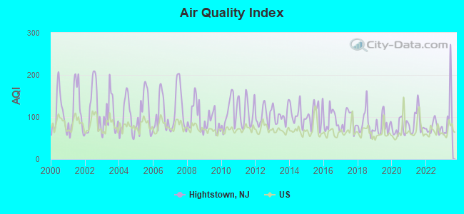
Air Quality Index (AQI) level in 2023 was 107. This is significantly worse than average.
City:
107
U.S.:
73
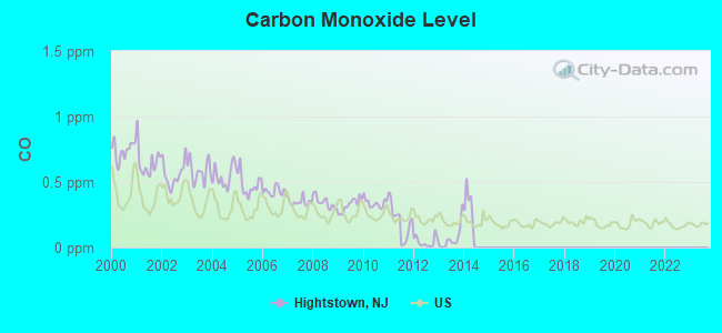
Carbon Monoxide (CO) [ppm] level in 2013 was 0.0690. This is significantly better than average.Closest monitor was 13.2 miles away from the city center.
City:
0.0690
U.S.:
0.2513
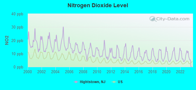
Nitrogen Dioxide (NO2) [ppb] level in 2022 was 7.95. This is significantly worse than average.Closest monitor was 5.3 miles away from the city center.
City:
7.95
U.S.:
5.11
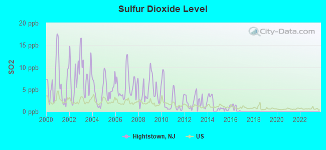
Sulfur Dioxide (SO2) [ppb] level in 2016 was 0.754. This is significantly better than average.Closest monitor was 11.6 miles away from the city center.
City:
0.754
U.S.:
1.515
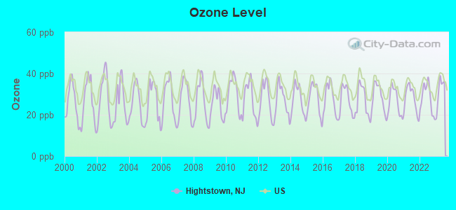
Ozone [ppb] level in 2023 was 31.6. This is about average.Closest monitor was 5.3 miles away from the city center.
City:
31.6
U.S.:
33.3
Particulate Matter (PM10) [µg/m3] level in 2008 was 16.0. This is better than average.Closest monitor was 13.0 miles away from the city center.
City:
16.0
U.S.:
19.2
Particulate Matter (PM2.5) [µg/m3] level in 2022 was 7.57. This is about average.Closest monitor was 11.6 miles away from the city center.
City:
7.57
U.S.:
8.11
Tornado activity:
Hightstown-area historical tornado activity is near New Jersey state average. It is 27% smaller than the overall U.S. average.
On 10/18/1990, a category F3 (max. wind speeds 158-206 mph) tornado 19.5 miles away from the Hightstown borough center injured 8 peopleand causedbetween $500,000 and $5,000,000 in damages.
On 5/24/1962, a category F2 (max. wind speeds 113-157 mph) tornado 5.1 miles away from the borough center injured one personand causedbetween $50,000 and $500,000 in damages.
Earthquake activity:
Hightstown-area historical earthquake activity is significantly above New Jersey state average. It is 68% smaller than the overall U.S. average.
On 8/23/2011 at 17:51:04, a magnitude 5.8 (5.8 MW, Depth: 3.7 mi, Class: Moderate, Intensity: VI - VII) earthquake occurred 245.3 miles away from Hightstown center On 1/16/1994 at 01:49:16, a magnitude 4.6 (4.6 MB, 4.6 LG, Depth: 3.1 mi, Class: Light, Intensity: IV - V) earthquake occurred 79.9 miles away from Hightstown center On 10/7/1983 at 10:18:46, a magnitude 5.3 (5.1 MB, 5.3 LG, 5.1 ML) earthquake occurred 254.9 miles away from the city center On 1/16/1994 at 00:42:43, a magnitude 4.2 (4.2 MB, 4.0 LG, Depth: 3.1 mi) earthquake occurred 78.3 miles away from the city center On 4/20/2002 at 10:50:47, a magnitude 5.3 (5.3 ML, Depth: 3.0 mi) earthquake occurred 296.5 miles away from Hightstown center On 4/20/2002 at 10:50:47, a magnitude 5.2 (5.2 MB, 4.2 MS, 5.2 MW, 5.0 MW) earthquake occurred 294.6 miles away from Hightstown center Magnitude types: regional Lg-wave magnitude (LG), body-wave magnitude (MB), local magnitude (ML), surface-wave magnitude (MS), moment magnitude (MW)
Natural disasters:
The number of natural disasters in Mercer County (25) is a lot greater than the US average (15). Major Disasters (Presidential) Declared: 16 Emergencies Declared: 9
Causes of natural disasters: Hurricanes: 7, Floods: 5, Storms: 4, Snowstorms: 3, Blizzards: 2, Heavy Rains: 2, Water Shortages: 2, Winter Storms: 2, Tornado: 1, Tropical Depression: 1, Tropical Storm: 1, Wind: 1, Other: 3 (Note: some incidents may be assigned to more than one category).
Hospitals and medical centers in Hightstown:
PRESBYTERIAN HOME - MEADOW LAKES (300 MEADOW LAKES)
SUN LAWN NURSING HOME (576 NORTH MAIN STREET)
Other hospitals and medical centers near Hightstown:
EMBRACING HOSPICECARE OF NEW JERSEY WEST LLC (Hospital, about 2 miles away; CRANBURY, NJ)
GARDENS AT MONROE HEALTHCARE AND REHABILITATION, T (Nursing Home, about 3 miles away; MONROE TOWNSHIP, NJ)
ELMS OF CRANBURY, THE (Nursing Home, about 4 miles away; CRANBURY, NJ)
CRANBURY CENTER (Nursing Home, about 4 miles away; MONROE TOWNSHIP, NJ)
DAVITA PRINCETON JUNCTION DIALYSIS (Dialysis Facility, about 6 miles away; PRINCETON JUNCTION, NJ)
MONROE VILLAGE HCC (Nursing Home, about 7 miles away; JAMESBURG, NJ)
MERWICK CARE AND REHABILITATION CENTER (Nursing Home, about 7 miles away; PLAINSBORO, NJ)
Churches in Hightstown include: First Presbyterian Church (A), First United Methodist Church (B), Saint James African Methodist Episcopal Church (C), Mount Olivet Baptist Church (D). Display/hide their locations on the map
Tourist attraction: Hightstown-East Windsor Historical Society (Museums; 164 North Main Street).
Hotels: Hampton Inn (384 Monmouth St), Days Inn (460 Route 33 East), Colonial-Windsor Motel (USHighway 130 North).
Birthplace of: Eli Thompson Fryer - Marine Corps Brigadier General, John Hundley - Television executive, Reid Lamberty - Television news host, Rich Gunnell - College football player (Boston College Eagles).
Mercer County has a predicted average indoor radon screening level greater than 4 pCi/L (pico curies per liter) - Highest Potential
Drinking water stations with addresses in Hightstown and their reported violations in the past:
HIGHTSTOWN WATER DEPARTMENT (Population served: 5,400, Groundwater):
Past health violations:
MCL, Monthly (TCR) - In JUL-2012, Contaminant: Coliform. Follow-up actions: St Public Notif requested (JUL-30-2012), St Formal NOV issued (JUL-30-2012), St Compliance achieved (AUG-01-2012), St Public Notif received (AUG-27-2012)
Past monitoring violations:
21 regular monitoring violations
Average household size:
This borough:
2.7 people
New Jersey:
2.7 people
Percentage of family households:
This borough:
68.4%
Whole state:
69.3%
Percentage of households with unmarried partners:
This borough:
6.1%
Whole state:
5.9%
Likely homosexual households (counted as self-reported same-sex unmarried-partner households)
Lesbian couples: 0.7% of all households
Gay men: 0.3% of all households
72 people in workers' group living quarters and job corps centers in 2010
22 people in group homes intended for adults in 2010
People in group quarters in Hightstown in 2000:
15 people in other noninstitutional group quarters
5 people in homes for the mentally retarded
2 people in religious group quarters
Banks with branches in Hightstown (2011 data):
1st Constitution Bank: Hightstown Branch at 140 Mercer Street, branch established on 2007/02/27. Info updated 2011/08/31: Bank assets: $791.7 mil, Deposits: $624.5 mil, headquarters in Cranbury, NJ, positive income, Commercial Lending Specialization, 14 total offices, Holding Company: 1st Constitution Bancorp
Wells Fargo Bank, National Association: Hightstown Branch at 105 South Main Street, branch established on 1870/01/01. Info updated 2011/04/05: Bank assets: $1,161,490.0 mil, Deposits: $905,653.0 mil, headquarters in Sioux Falls, SD, positive income, 6395 total offices, Holding Company: Wells Fargo & Company
JPMorgan Chase Bank, National Association: East Windsor Banking Center at 392 Us Highway 130, branch established on 2009/12/15. Info updated 2011/11/10: Bank assets: $1,811,678.0 mil, Deposits: $1,190,738.0 mil, headquarters in Columbus, OH, positive income, International Specialization, 5577 total offices, Holding Company: Jpmorgan Chase & Co.
Bank of America, National Association: East Windsor Shop Rite at 319 Ushy 130, branch established on 1998/02/25. Info updated 2009/11/18: Bank assets: $1,451,969.3 mil, Deposits: $1,077,176.8 mil, headquarters in Charlotte, NC, positive income, 5782 total offices, Holding Company: Bank Of America Corporation
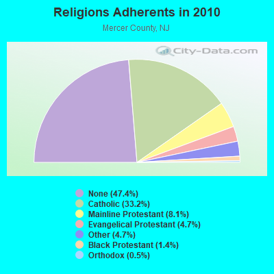
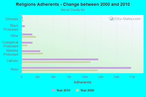
Religion statistics for Hightstown, NJ (based on Mercer County data)
Religion
Adherents
Congregations
Catholic
121,650
26
Mainline Protestant
29,638
86
Evangelical Protestant
17,274
91
Other
17,115
38
Black Protestant
5,146
30
Orthodox
1,960
5
None
173,730
-
Source: Clifford Grammich, Kirk Hadaway, Richard Houseal, Dale E.Jones, Alexei Krindatch, Richie Stanley and Richard H.Taylor. 2012. 2010 U.S.Religion Census: Religious Congregations & Membership Study. Association of Statisticians of American Religious Bodies. Jones, Dale E., et al. 2002. Congregations and Membership in the United States 2000. Nashville, TN: Glenmary Research Center. Graphs represent county-level data
Aircraft: CZECH SPORT AIRCRAFT AS PIPER SPORT (Category: Land, Seats: 2, Weight: Up to 12,499 Pounds), Engine: ROTAX 912ULS SERIES (100 HP) (4 Cycle) N-Number: 31SH, N31SH, N-31SH, Serial Number: P1001065, Year manufactured: 2010, Airworthiness Date: 01/18/2011, Certificate Issue Date: 09/27/2019 Registrant (Individual): Glenn C Heidel, 105 Hutchinson St, Hightstown, NJ 08520
Aircraft: BOEING B75 (Category: Land, Seats: 2, Weight: Up to 12,499 Pounds, Speed: 93 mph), Engine: LYCOMING R680-4P-B4 (225 HP) (Reciprocating) N-Number: 46Y, N46Y, N-46Y, Serial Number: 75-1377, Year manufactured: 1941, Airworthiness Date: 08/17/1961, Certificate Issue Date: 06/07/2001 Registrant (Individual): Quentin G Marty, 12 Huber Ct, Hightstown, NJ 08520
Aircraft: CESSNA 150F (Category: Land, Seats: 2, Weight: Up to 12,499 Pounds, Speed: 90 mph), Engine: CONT MOTOR 0-200 SERIES (100 HP) (Reciprocating) N-Number: 7846F, N7846F, N-7846F, Serial Number: 15063946, Year manufactured: 1966, Airworthiness Date: 04/28/1966, Certificate Issue Date: 01/13/2010 Registrant (Individual): Steven M Grossman, Po Box 746, Hightstown, NJ 08520
Aircraft: BEECH 56TC (Category: Land, Engines: 2, Seats: 6, Weight: Up to 12,499 Pounds, Speed: 165 mph), Engine: LYCOMING TI0-541 SER (310 HP) (Reciprocating) N-Number: 79X, N79X, N-79X, Serial Number: TG-26, Year manufactured: 1967, Airworthiness Date: 10/06/1967, Certificate Issue Date: 05/26/2004 Registrant (LLC): Rumson Capital Holdings LLC, Po Box 1550, Hightstown, NJ 08520
Aircraft: PIPER PA-18 (Category: Land, Seats: 2, Weight: Up to 12,499 Pounds, Speed: 97 mph), Engine: CONT MOTOR C90 SERIES (95 HP) (Reciprocating) N-Number: 9375D, N9375D, N-9375D, Serial Number: 18-6640, Year manufactured: 1958 Registrant (Individual): Alan W Bowen, 564 S Main St, Hightstown, NJ 08520 Deregistered:Cancel Date: 11/02/2018
Aircraft: WESTLAND BELL 47G3 B1 SOLOY (Category: Land, Seats: 3, Weight: Up to 12,499 Pounds), Engine: Turbo-shaft N-Number: 22549, N22549, N-22549, Serial Number: WAN-045, Certificate Issue Date: 09/14/1999 Registrant (Corporation): C & C Brokerage & Leasing Inc, 145 Applegarth Rd, Hightstown, NJ 08520 Deregistered:Cancel Date: 07/01/1996, Exported to: Canada
Home Mortgage Disclosure Act Aggregated Statistics For Year 2009 (Based on 1 full tract)
A) FHA, FSA/RHS & VA Home Purchase Loans
B) Conventional Home Purchase Loans
C) Refinancings
D) Home Improvement Loans
E) Loans on Dwellings For 5+ Families
F) Non-occupant Loans on < 5 Family Dwellings (A B C & D)
Number
Average Value
Number
Average Value
Number
Average Value
Number
Average Value
Number
Average Value
Number
Average Value
LOANS ORIGINATED
19
$208,000
28
$206,571
102
$192,647
3
$104,000
0
$0
3
$170,667
APPLICATIONS APPROVED, NOT ACCEPTED
0
$0
2
$319,000
18
$181,944
0
$0
0
$0
0
$0
APPLICATIONS DENIED
5
$212,600
6
$244,833
66
$248,667
4
$111,750
1
$12,500,000
2
$388,500
APPLICATIONS WITHDRAWN
1
$231,000
5
$245,800
35
$235,400
1
$250,000
0
$0
2
$161,000
FILES CLOSED FOR INCOMPLETENESS
0
$0
1
$162,000
8
$279,250
0
$0
0
$0
0
$0
Aggregated Statistics For Year 2008 (Based on 1 full tract)
A) FHA, FSA/RHS & VA Home Purchase Loans
B) Conventional Home Purchase Loans
C) Refinancings
D) Home Improvement Loans
F) Non-occupant Loans on < 5 Family Dwellings (A B C & D)
Number
Average Value
Number
Average Value
Number
Average Value
Number
Average Value
Number
Average Value
LOANS ORIGINATED
13
$223,231
39
$211,231
65
$191,677
8
$63,625
8
$169,750
APPLICATIONS APPROVED, NOT ACCEPTED
0
$0
7
$353,571
13
$171,077
1
$60,000
2
$101,500
APPLICATIONS DENIED
3
$256,667
8
$288,250
70
$228,786
11
$36,091
2
$30,000
APPLICATIONS WITHDRAWN
1
$195,000
7
$249,571
20
$246,550
1
$25,000
3
$151,667
FILES CLOSED FOR INCOMPLETENESS
0
$0
0
$0
6
$223,500
0
$0
0
$0
Aggregated Statistics For Year 2007 (Based on 1 full tract)
A) FHA, FSA/RHS & VA Home Purchase Loans
B) Conventional Home Purchase Loans
C) Refinancings
D) Home Improvement Loans
E) Loans on Dwellings For 5+ Families
F) Non-occupant Loans on < 5 Family Dwellings (A B C & D)
Number
Average Value
Number
Average Value
Number
Average Value
Number
Average Value
Number
Average Value
Number
Average Value
LOANS ORIGINATED
5
$223,200
97
$222,732
105
$185,314
19
$68,526
1
$177,000
14
$195,214
APPLICATIONS APPROVED, NOT ACCEPTED
1
$336,000
10
$271,800
33
$168,242
5
$82,400
0
$0
1
$140,000
APPLICATIONS DENIED
1
$270,000
24
$248,167
80
$212,950
17
$75,000
0
$0
4
$152,500
APPLICATIONS WITHDRAWN
1
$202,000
15
$229,333
39
$240,846
2
$10,000
0
$0
4
$230,500
FILES CLOSED FOR INCOMPLETENESS
0
$0
3
$142,333
13
$245,923
0
$0
0
$0
1
$182,000
Aggregated Statistics For Year 2006 (Based on 1 full tract)
A) FHA, FSA/RHS & VA Home Purchase Loans
B) Conventional Home Purchase Loans
C) Refinancings
D) Home Improvement Loans
F) Non-occupant Loans on < 5 Family Dwellings (A B C & D)
Number
Average Value
Number
Average Value
Number
Average Value
Number
Average Value
Number
Average Value
LOANS ORIGINATED
4
$308,750
104
$194,798
161
$202,783
23
$85,348
18
$202,333
APPLICATIONS APPROVED, NOT ACCEPTED
0
$0
14
$258,000
39
$170,179
14
$53,143
5
$99,200
APPLICATIONS DENIED
0
$0
30
$224,767
78
$215,526
8
$111,875
8
$202,375
APPLICATIONS WITHDRAWN
0
$0
19
$221,842
67
$214,313
3
$136,000
5
$212,400
FILES CLOSED FOR INCOMPLETENESS
0
$0
5
$201,600
17
$242,353
2
$142,000
1
$278,000
Aggregated Statistics For Year 2005 (Based on 1 full tract)
A) FHA, FSA/RHS & VA Home Purchase Loans
B) Conventional Home Purchase Loans
C) Refinancings
D) Home Improvement Loans
E) Loans on Dwellings For 5+ Families
F) Non-occupant Loans on < 5 Family Dwellings (A B C & D)
G) Loans On Manufactured Home Dwelling (A B C & D)
Number
Average Value
Number
Average Value
Number
Average Value
Number
Average Value
Number
Average Value
Number
Average Value
Number
Average Value
LOANS ORIGINATED
3
$231,667
132
$198,924
173
$191,318
25
$77,560
2
$2,191,500
24
$207,000
0
$0
APPLICATIONS APPROVED, NOT ACCEPTED
2
$201,500
15
$187,400
39
$180,846
5
$42,600
0
$0
3
$103,333
0
$0
APPLICATIONS DENIED
0
$0
21
$214,143
75
$202,853
22
$60,636
0
$0
9
$194,444
2
$164,000
APPLICATIONS WITHDRAWN
3
$245,667
17
$223,882
80
$219,412
8
$215,125
1
$25,000
7
$245,571
0
$0
FILES CLOSED FOR INCOMPLETENESS
0
$0
4
$213,750
11
$257,273
0
$0
0
$0
3
$210,667
0
$0
Aggregated Statistics For Year 2004 (Based on 1 full tract)
A) FHA, FSA/RHS & VA Home Purchase Loans
B) Conventional Home Purchase Loans
C) Refinancings
D) Home Improvement Loans
F) Non-occupant Loans on < 5 Family Dwellings (A B C & D)
Number
Average Value
Number
Average Value
Number
Average Value
Number
Average Value
Number
Average Value
LOANS ORIGINATED
6
$209,500
124
$215,113
163
$174,969
25
$48,360
17
$167,706
APPLICATIONS APPROVED, NOT ACCEPTED
0
$0
9
$192,889
21
$148,762
5
$23,400
2
$52,000
APPLICATIONS DENIED
2
$218,500
31
$219,097
58
$172,586
16
$68,312
6
$156,667
APPLICATIONS WITHDRAWN
2
$247,500
13
$219,538
62
$192,177
8
$102,125
3
$149,333
FILES CLOSED FOR INCOMPLETENESS
1
$193,000
4
$302,250
10
$183,900
0
$0
0
$0
Aggregated Statistics For Year 2003 (Based on 1 full tract)
A) FHA, FSA/RHS & VA Home Purchase Loans
B) Conventional Home Purchase Loans
C) Refinancings
D) Home Improvement Loans
F) Non-occupant Loans on < 5 Family Dwellings (A B C & D)
Number
Average Value
Number
Average Value
Number
Average Value
Number
Average Value
Number
Average Value
LOANS ORIGINATED
11
$158,727
122
$185,082
356
$145,728
13
$58,538
31
$100,968
APPLICATIONS APPROVED, NOT ACCEPTED
0
$0
18
$203,167
58
$120,672
9
$53,333
3
$112,333
APPLICATIONS DENIED
0
$0
11
$183,273
89
$127,697
18
$39,444
7
$134,143
APPLICATIONS WITHDRAWN
0
$0
21
$173,905
62
$150,968
2
$15,000
0
$0
FILES CLOSED FOR INCOMPLETENESS
0
$0
9
$227,444
23
$192,565
1
$30,000
1
$145,000
Aggregated Statistics For Year 2002 (Based on 1 full tract)
A) FHA, FSA/RHS & VA Home Purchase Loans
B) Conventional Home Purchase Loans
C) Refinancings
D) Home Improvement Loans
E) Loans on Dwellings For 5+ Families
F) Non-occupant Loans on < 5 Family Dwellings (A B C & D)
Number
Average Value
Number
Average Value
Number
Average Value
Number
Average Value
Number
Average Value
Number
Average Value
LOANS ORIGINATED
14
$139,143
151
$759,649
193
$186,461
16
$59,312
2
$4,020,000
21
$3,836,810
APPLICATIONS APPROVED, NOT ACCEPTED
1
$179,000
23
$183,826
35
$112,486
3
$26,000
0
$0
2
$36,000
APPLICATIONS DENIED
1
$123,000
17
$136,294
67
$104,642
7
$11,429
1
$8,500,000
4
$79,500
APPLICATIONS WITHDRAWN
0
$0
18
$787,389
39
$120,231
1
$35,000
0
$0
3
$4,029,000
FILES CLOSED FOR INCOMPLETENESS
1
$182,000
5
$221,200
8
$141,125
1
$30,000
0
$0
0
$0
Aggregated Statistics For Year 2001 (Based on 1 full tract)
A) FHA, FSA/RHS & VA Home Purchase Loans
B) Conventional Home Purchase Loans
C) Refinancings
D) Home Improvement Loans
F) Non-occupant Loans on < 5 Family Dwellings (A B C & D)
Number
Average Value
Number
Average Value
Number
Average Value
Number
Average Value
Number
Average Value
LOANS ORIGINATED
28
$123,036
95
$133,116
133
$120,857
22
$41,182
10
$108,700
APPLICATIONS APPROVED, NOT ACCEPTED
1
$75,000
11
$101,818
23
$83,348
7
$34,286
1
$76,000
APPLICATIONS DENIED
3
$87,000
12
$155,083
43
$113,116
22
$24,500
2
$98,000
APPLICATIONS WITHDRAWN
3
$123,667
17
$128,294
40
$100,250
4
$75,500
0
$0
FILES CLOSED FOR INCOMPLETENESS
1
$171,000
2
$168,000
11
$107,545
1
$52,000
0
$0
Aggregated Statistics For Year 2000 (Based on 1 full tract)
A) FHA, FSA/RHS & VA Home Purchase Loans
B) Conventional Home Purchase Loans
C) Refinancings
D) Home Improvement Loans
F) Non-occupant Loans on < 5 Family Dwellings (A B C & D)
Number
Average Value
Number
Average Value
Number
Average Value
Number
Average Value
Number
Average Value
LOANS ORIGINATED
21
$106,238
112
$138,938
35
$86,343
17
$26,824
10
$80,800
APPLICATIONS APPROVED, NOT ACCEPTED
4
$134,750
27
$179,185
13
$84,769
7
$29,857
3
$61,333
APPLICATIONS DENIED
3
$118,333
13
$155,231
41
$70,829
14
$32,857
2
$131,500
APPLICATIONS WITHDRAWN
4
$113,500
13
$156,615
27
$61,630
1
$35,000
0
$0
FILES CLOSED FOR INCOMPLETENESS
0
$0
1
$292,000
6
$37,667
0
$0
0
$0
Aggregated Statistics For Year 1999 (Based on 1 partial tract)
A) FHA, FSA/RHS & VA Home Purchase Loans
B) Conventional Home Purchase Loans
C) Refinancings
D) Home Improvement Loans
E) Loans on Dwellings For 5+ Families
F) Non-occupant Loans on < 5 Family Dwellings (A B C & D)
Detailed PMIC statistics for the following Tracts:0044.03
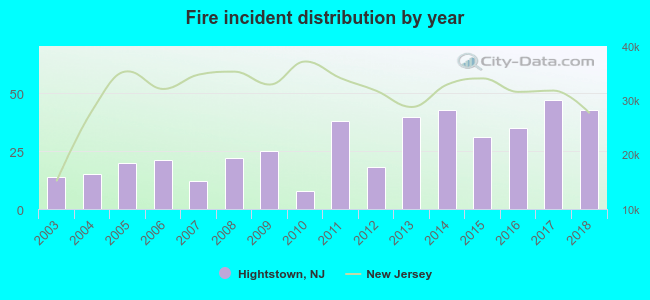
2003 - 2018 National Fire Incident Reporting System (NFIRS) incidents
According to the data from the years 2003 - 2018 the average number of fire incidents per year is 27. The highest number of fire incidents - 47 took place in 2017, and the least - 8 in 2010. The data has an increasing trend.
When looking into fire subcategories, the most incidents belonged to: Structure Fires (72.5%), and Mobile Property/Vehicle Fires (12.2%).
Fire incident types reported to NFIRS in Hightstown, NJ
#5 on the list of "Top 101 cities with the most residents born in Ecuador (population 500+)"
#41 on the list of "Top 101 cities with the most residents born in South America (population 500+)"
#53 on the list of "Top 101 cities with the most residents born in Other Western Africa (population 500+)"
#66 on the list of "Top 101 cities with largest percentage of females in industries: transportation and warehousing (population 5,000+)"
#84 on the list of "Top 101 cities with largest percentage of males in industries: administrative and support and waste management services (population 5,000+)"
#14 on the list of "Top 101 counties with the largest increase in the number of infant deaths per 1000 residents 2000-2006 to 2007-2013 (pop. 50,000+)"
#22 on the list of "Top 101 counties with the lowest percentage of residents that keep firearms around their homes"
#34 on the list of "Top 101 counties with the highest average weight of females"
#39 on the list of "Top 101 counties with the highest number of infant deaths per 1000 residents 2007-2013 (pop. 50,000+)"
#40 on the list of "Top 101 counties with the largest number of people moving out compared to moving in (pop. 50,000+)"


 Recent articles from our blog. Our writers, many of them Ph.D. graduates or candidates, create easy-to-read articles on a wide variety of topics.

 (12.7 miles


 According to the data from the years 2003 - 2018 the average number of fire incidents per year is 27. The highest number of fire incidents - 47 took place in 2017, and the least - 8 in 2010. The data has an increasing trend.
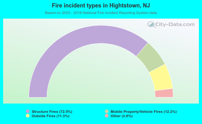 When looking into fire subcategories, the most incidents belonged to: Structure Fires (72.5%), and Mobile Property/Vehicle Fires (12.2%).