Bridge Statistics for Stockton, California (CA)
Condition, Traffic, Stress, Structural Evaluation, Project Costs
- National Bridge Inventory (NBI) Statistics
- 327Number of bridges
- 5,604ft / 1,708mTotal length
- $142,880,000Total costs
- 8,556,472Total average daily traffic
- 1,227,785Total average daily truck traffic
- National Bridge Inventory (NBI) Registered Bridges for Stockton
- No street view available for this location
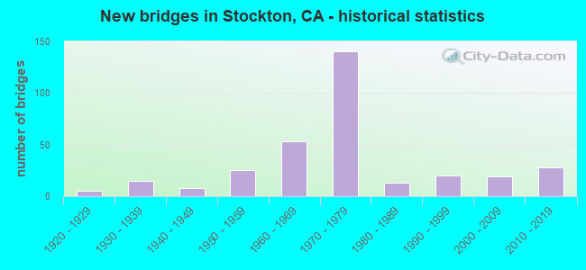
- New bridges - historical statistics
- 11910-1919
- 51920-1929
- 151930-1939
- 81940-1949
- 251950-1959
- 531960-1969
- 1401970-1979
- 131980-1989
- 201990-1999
- 192000-2009
- 282010-2019

- Reconstructed bridges - Historical Statistics
- 21940-1949
- 01950-1959
- 61960-1969
- 41970-1979
- 31980-1989
- 81990-1999
- 92000-2009
- 152010-2019


- Bridge Condition - Deck
- 40.6%Good
- 9.9%Satisfactory
- 36.6%Fair
- 12.9%Poor

- Bridge Condition - Superstructure
- 58.1%Good
- 5.9%Satisfactory
- 26.1%Fair
- 9.9%Poor

- Bridge Condition - Substructure
- 78.8%Good
- 4.4%Satisfactory
- 16.7%Fair

- Bridge Condition - Channel
- 6.9%Excellent
- 22.8%Very good
- 42.1%Good
- 20.7%Satisfactory
- 5.5%Fair
- 1.4%Poor
- 0.7%Serious

- Bridge Condition - Culverts
- 4.0%Very good
- 44.0%Good
- 48.0%Satisfactory
- 4.0%Poor
Find on map >> Show street view
Structure Number: 29C0416, Location: .9 MI W OF W LINNE RD (Lat: 37.678889, Lng: -121.434450), Route carried "on" structure: County highway , Year Built: 1948, Status: Open, Structure Length: 2.16m (7.09ft), Average Daily Traffic: 1,680 (year 2002), Truck Traffic: 12%, Average Future Daily Traffic: 2,130 (year 2034), Features Intersected: Delta-Mendota Canal, Facility Carried by Structure: S Tracy Blvd
Minimum Vertical Clearance: 30+ m (98+ ft), Kilometerpoint: 26.114, Lanes on structure: 2, Owner: Bureau of Reclamation, Approaching Roadway Width: 6.7m (22.0ft), Skew: 4 degrees, Material/Design: Concrete continuous, Design/Construction: Culvert, Number Of Spans In Main Unit: 4, Length of Maximum Span: 5.2m (17.1ft)
Condition: Channel: Excellent, Culverts: Very good, Operating Rating: 54.0 metric tons, Method Used To Determine Operating Rating: Field evaluation and documented engineering judgment, Inventory Rating: 32.4 metric tons, Method Used To Determine Inventory Rating: Field evaluation and documented engineering judgment, Structural Evaluation: Equal to present desirable criteria, Waterway Adequacy: Superior to present desirable criteria, Approach Roadway Alignment: Superior to present desirable criteria, Designated Inspection Frequency: Every 48 months, Underwater Inspection Frequency: Every 60 months, Inspection Date: Febuary 2020, Underwater Inspection Date: Febuary 2020
Find on map >> Show street view
Structure Number: 29 0008L, Location: 10-SJ-099-21.79 (Lat: 38.004611, Lng: -121.257828), Route carried "on" structure: State highway 99, Year Built: 1930, Year Reconstructed: 2007, Status: Open, Structure Length: 3.11m (10.20ft), Average Daily Traffic: 35,500 (year 2009), Truck Traffic: 13%, Average Future Daily Traffic: 59,520 (year 2040), Design Load: HS 15, Features Intersected: CALAVERAS RIVER
Minimum Vertical Clearance: 30+ m (98+ ft), Kilometerpoint: 21.790, Lanes on structure: 4, Base Highway Network: Yes (, Subroute: 1), Owner: State Highway Agency, Approaching Roadway Width: 20.7m (67.9ft), Skew: 2 degrees, Material/Design: Concrete continuous, Design/Construction: Tee Beam, Number Of Spans In Main Unit: 3, Length of Maximum Span: 10.4m (34.1ft), Curb-To-Curb Width: 20.7m (67.9ft), Out-to-Out Width: 21.8m (71.5ft)
Condition: Deck: Good, Superstructure: Good, Substructure: Fair, Channel: Good, Operating Rating: 29.8 metric tons, Method Used To Determine Operating Rating: Load and Resistance Factor Rating (LRFR) rating reported by rating factor(RF) method using HL-93 loadings, Inventory Rating: 23.0 metric tons, Method Used To Determine Inventory Rating: Load and Resistance Factor Rating (LRFR) rating reported by rating factor(RF) method using HL-93 loadings, Structural Evaluation: Somewhat better than minimum adequacy, Deck Geometry: Equal to present minimum criteria, Waterway Adequacy: Equal to present desirable criteria, Approach Roadway Alignment: Equal to present desirable criteria, Length Of Structure Improvement: 3.11m (10.20ft), Designated Inspection Frequency: Every 24 months, Inspection Date: June 2020, Deck Structure Type: Concrete Cast-file-Place, Wearing Surface/Protective System: Wearing Surface: Bituminous
Find on map >> Show street view
Structure Number: 29 0008R, Location: 10-SJ-099-21.79 (Lat: 38.004747, Lng: -121.257403), Route carried "on" structure: State highway 99, Year Built: 1949, Year Reconstructed: 2007, Status: Open, Structure Length: 4.08m (13.39ft), Average Daily Traffic: 35,500 (year 2009), Truck Traffic: 13%, Average Future Daily Traffic: 59,520 (year 2040), Design Load: HS 20, Features Intersected: CALAVERAS RIVER
Minimum Vertical Clearance: 30+ m (98+ ft), Kilometerpoint: 21.790, Lanes on structure: 4, Base Highway Network: Yes (, Subroute: 1), Owner: State Highway Agency, Approaching Roadway Width: 19.8m (65.0ft), Skew: 1 degrees, Material/Design: Steel, Design/Construction: Stringer/Multi-beam, Number Of Spans In Main Unit: 3, Length of Maximum Span: 16.5m (54.1ft), Curb-To-Curb Width: 19.8m (65.0ft), Out-to-Out Width: 20.8m (68.2ft)
Condition: Deck: Good, Superstructure: Good, Substructure: Good, Channel: Good, Operating Rating: 61.6 metric tons, Method Used To Determine Operating Rating: Load Factor (LF), Inventory Rating: 36.9 metric tons, Method Used To Determine Inventory Rating: Load Factor (LF), Structural Evaluation: Better than present minimum criteria, Deck Geometry: Equal to present minimum criteria, Waterway Adequacy: Equal to present desirable criteria, Approach Roadway Alignment: Equal to present desirable criteria, Length Of Structure Improvement: 4.08m (13.39ft), Designated Inspection Frequency: Every 24 months, Inspection Date: June 2020, Deck Structure Type: Concrete Cast-file-Place, Wearing Surface/Protective System: Wearing Surface: Bituminous
Find on map >> Show street view
Structure Number: 29 0014, Location: 10-SJ-099-15.22 (Lat: 37.913222, Lng: -121.226031), Route carried "on" structure: State highway 99, Year Built: 1956, Status: Open, Structure Length: 0.61m (2.00ft), Average Daily Traffic: 70,500 (year 2009), Truck Traffic: 20%, Average Future Daily Traffic: 91,368 (year 2040), Features Intersected: BERGS CANAL
Minimum Vertical Clearance: 30+ m (98+ ft), Kilometerpoint: 15.220, Lanes on structure: 4, Base Highway Network: Yes (, Subroute: 1), Owner: State Highway Agency, Approaching Roadway Width: 21.4m (70.2ft), Skew: 31 degrees, Material/Design: Concrete continuous, Design/Construction: Culvert, Number Of Spans In Main Unit: 2, Length of Maximum Span: 3.0m (9.8ft)
Condition: Channel: Good, Culverts: Good, Operating Rating: 54.1 metric tons, Method Used To Determine Operating Rating: Field evaluation and documented engineering judgment, Inventory Rating: 32.4 metric tons, Method Used To Determine Inventory Rating: Field evaluation and documented engineering judgment, Structural Evaluation: Better than present minimum criteria, Waterway Adequacy: Better than present minimum criteria, Approach Roadway Alignment: Equal to present desirable criteria, Designated Inspection Frequency: Every 24 months, Inspection Date: June 2020
Find on map >> Show street view
Structure Number: 29 0017, Location: 10-SJ-099-12.53 (Lat: 37.874953, Lng: -121.219419), Route carried "on" structure: State highway 99, Year Built: 1955, Year Reconstructed: 2014, Status: Open, Structure Length: 2.10m (6.89ft), Average Daily Traffic: 35,250 (year 2009), Truck Traffic: 13%, Average Future Daily Traffic: 46,049 (year 2040), Design Load: HS 20, Features Intersected: LITTLEJOHNS CREEK
Minimum Vertical Clearance: 30+ m (98+ ft), Kilometerpoint: 12.530, Lanes on structure: 6, Base Highway Network: Yes (, Subroute: 1), Owner: State Highway Agency, Approaching Roadway Width: 32.6m (107.0ft), Skew: 31 degrees, Material/Design: Concrete continuous, Design/Construction: Slab, Number Of Spans In Main Unit: 3, Length of Maximum Span: 7.1m (23.3ft), Curb-To-Curb Width: 32.6m (107.0ft), Out-to-Out Width: 33.3m (109.3ft)
Condition: Deck: Good, Superstructure: Good, Substructure: Good, Channel: Satisfactory, Operating Rating: 56.1 metric tons, Method Used To Determine Operating Rating: Load Factor (LF), Inventory Rating: 33.7 metric tons, Method Used To Determine Inventory Rating: Load Factor (LF), Structural Evaluation: Better than present minimum criteria, Deck Geometry: Superior to present desirable criteria, Waterway Adequacy: Equal to present minimum criteria, Approach Roadway Alignment: Equal to present desirable criteria, Designated Inspection Frequency: Every 24 months, Inspection Date: June 2020, Deck Structure Type: Concrete Cast-file-Place, Wearing Surface/Protective System: Wearing Surface: Integral Concrete
Find on map >> Show street view
Structure Number: 29 0019, Location: 10-SJ-099-12.33 (Lat: 37.872003, Lng: -121.219203), Route carried "on" structure: State highway 99, Year Built: 1955, Year Reconstructed: 2014, Status: Open, Structure Length: 2.39m (7.84ft), Average Daily Traffic: 35,250 (year 2009), Truck Traffic: 13%, Average Future Daily Traffic: 46,049 (year 2040), Design Load: HS 20, Features Intersected: FRENCH CAMP SLOUGH
Minimum Vertical Clearance: 30+ m (98+ ft), Kilometerpoint: 12.330, Lanes on structure: 6, Base Highway Network: Yes (, Subroute: 1), Owner: State Highway Agency, Approaching Roadway Width: 32.6m (107.0ft), Skew: 1 degrees, Material/Design: Concrete continuous, Design/Construction: Slab, Number Of Spans In Main Unit: 4, Length of Maximum Span: 6.2m (20.3ft), Curb-To-Curb Width: 32.6m (107.0ft), Out-to-Out Width: 33.7m (110.6ft)
Condition: Deck: Good, Superstructure: Good, Substructure: Fair, Channel: Satisfactory, Operating Rating: 39.2 metric tons, Method Used To Determine Operating Rating: Load and Resistance Factor Rating (LRFR) rating reported by rating factor(RF) method using HL-93 loadings, Inventory Rating: 30.5 metric tons, Method Used To Determine Inventory Rating: Load and Resistance Factor Rating (LRFR) rating reported by rating factor(RF) method using HL-93 loadings, Structural Evaluation: Somewhat better than minimum adequacy, Deck Geometry: Superior to present desirable criteria, Waterway Adequacy: Equal to present minimum criteria, Approach Roadway Alignment: Equal to present desirable criteria, Designated Inspection Frequency: Every 24 months, Inspection Date: June 2020, Deck Structure Type: Concrete Cast-file-Place, Wearing Surface/Protective System: Wearing Surface: Integral Concrete
Find on map >> Show street view
Structure Number: 29 0023, Location: 10-SJ-099-11.80 (Lat: 37.864408, Lng: -121.218933), Route carried "on" structure: State highway 99, Year Built: 1955, Year Reconstructed: 2014, Status: Open, Structure Length: 1.92m (6.30ft), Average Daily Traffic: 70,500 (year 2009), Truck Traffic: 13%, Average Future Daily Traffic: 92,715 (year 2042), Design Load: HS 20+Mod, Features Intersected: LONE TREE SLOUGH
Minimum Vertical Clearance: 30+ m (98+ ft), Kilometerpoint: 11.800, Lanes on structure: 8, Base Highway Network: Yes (, Subroute: 1), Owner: State Highway Agency, Approaching Roadway Width: 40.3m (132.2ft), Skew: 32 degrees, Material/Design: Concrete continuous, Design/Construction: Slab, Number Of Spans In Main Unit: 3, Length of Maximum Span: 6.1m (20.0ft), Curb-To-Curb Width: 40.3m (132.2ft), Out-to-Out Width: 41.2m (135.2ft)
Condition: Deck: Good, Superstructure: Good, Substructure: Fair, Channel: Very good, Operating Rating: 33.7 metric tons, Method Used To Determine Operating Rating: Load and Resistance Factor Rating (LRFR) rating reported by rating factor(RF) method using HL-93 loadings, Inventory Rating: 25.9 metric tons, Method Used To Determine Inventory Rating: Load and Resistance Factor Rating (LRFR) rating reported by rating factor(RF) method using HL-93 loadings, Structural Evaluation: Somewhat better than minimum adequacy, Deck Geometry: Superior to present desirable criteria, Waterway Adequacy: Better than present minimum criteria, Approach Roadway Alignment: Equal to present desirable criteria, Designated Inspection Frequency: Every 24 months, Inspection Date: October 2020, Deck Structure Type: Concrete Cast-file-Place, Wearing Surface/Protective System: Wearing Surface: Integral Concrete, Deck Protection: Bituminous
Find on map >> Show street view
Structure Number: 29 0023K, Location: 10-SJ-099-11.80 (Lat: 37.864453, Lng: -121.219125), Route carried "on" structure: Ramp State highway 99, Year Built: 2014, Status: Open, Structure Length: 1.86m (6.10ft), Average Daily Traffic: 70,500 (year 2009), Truck Traffic: 13%, Average Future Daily Traffic: 92,715 (year 2042), Design Load: HL 93, Features Intersected: LONE TREE SLOUGH
Minimum Vertical Clearance: 30+ m (98+ ft), Kilometerpoint: 11.800, Lanes on structure: 1, Base Highway Network: Yes (, Subroute: 1), Owner: State Highway Agency, Approaching Roadway Width: 7.3m (24.0ft), Skew: 1 degrees, Material/Design: Concrete continuous, Design/Construction: Slab, Number Of Spans In Main Unit: 3, Length of Maximum Span: 6.4m (21.0ft), Curb-To-Curb Width: 7.3m (24.0ft), Out-to-Out Width: 8.2m (26.9ft)
Condition: Deck: Fair, Superstructure: Fair, Substructure: Good, Channel: Satisfactory, Operating Rating: 42.1 metric tons, Method Used To Determine Operating Rating: Assigned ratings based on Load and Resistance Factor Design (LRFD) reported by rating factor (RF) using HL93 loadings, Inventory Rating: 32.4 metric tons, Method Used To Determine Inventory Rating: Assigned ratings based on Load and Resistance Factor Design (LRFD) reported by rating factor (RF) using HL93 loadings, Structural Evaluation: Somewhat better than minimum adequacy, Deck Geometry: Better than present minimum criteria, Waterway Adequacy: Superior to present desirable criteria, Approach Roadway Alignment: Equal to present desirable criteria, Designated Inspection Frequency: Every 24 months, Inspection Date: October 2020, Deck Structure Type: Concrete Cast-file-Place
Find on map >> Show street view
Structure Number: 29 005, Location: 10-SJ-004-14.15 (Lat: 37.928536, Lng: -121.328275), Route carried "on" structure: State highway 4, Year Built: 1933, Status: Open, Structure Length: 9.20m (30.18ft), Average Daily Traffic: 19,950 (year 2009), Truck Traffic: 17%, Average Future Daily Traffic: 20,919 (year 2043), Design Load: H 15, Features Intersected: SAN JOAQUIN RIVER
Minimum Vertical Clearance: 4.80m (15.75ft), Kilometerpoint: 14.150, Lanes on structure: 2, Base Highway Network: Yes (, Subroute: 1), Owner: State Highway Agency, Approaching Roadway Width: 8.8m (28.9ft), Navigation Control: Yes ( Vertical Clearance: 4.6m (15.1ft), Horizontal Clearance: 31.1m (102.0ft)), Material/Design: Steel, Design/Construction: Movable - Swing, Number Of Spans In Main Unit: 2, Number Of Approach Spans: 1, Length of Maximum Span: 39.3m (128.9ft), Curb or Sidewalk Widths: Left: 0.2m (0.7ft), Right: 1.1m (3.6ft), Curb-To-Curb Width: 7.3m (24.0ft), Out-to-Out Width: 7.8m (25.6ft)
Condition: Deck: Fair, Superstructure: Fair, Substructure: Fair, Channel: Satisfactory, Operating Rating: 45.7 metric tons, Method Used To Determine Operating Rating: Load Factor (LF), Inventory Rating: 27.2 metric tons, Method Used To Determine Inventory Rating: Load Factor (LF), Structural Evaluation: Somewhat better than minimum adequacy, Deck Geometry: High priority of replacement, Waterway Adequacy: Better than present minimum criteria, Approach Roadway Alignment: Equal to present desirable criteria, Designated Inspection Frequency: Every 24 months, Critical Feature Inspection Frequency: Every 24 months, Underwater Inspection Frequency: Every 60 months, Inspection Date: April 2021, Critical Feature Inspection Date: August 2021, Underwater Inspection Date: September 2019, Deck Structure Type: Concrete Cast-file-Place, Wearing Surface/Protective System: Wearing Surface: Integral Concrete
Find on map >> Show street view
Structure Number: 29 0051, Location: 10-SJ-004-14.22 (Lat: 37.928900, Lng: -121.326956), Route carried "on" structure: State highway 4, Year Built: 1933, Status: Open, Structure Length: 0.76m (2.49ft), Average Daily Traffic: 19,950 (year 2009), Truck Traffic: 17%, Average Future Daily Traffic: 17,401 (year 2041), Design Load: H 15, Features Intersected: PRIVATE ACCESS
Minimum Vertical Clearance: 30+ m (98+ ft), Kilometerpoint: 14.220, Lanes on structure: 2, Base Highway Network: Yes (, Subroute: 1), Owner: State Highway Agency, Approaching Roadway Width: 7.9m (25.9ft), Material/Design: Steel, Design/Construction: Stringer/Multi-beam, Number Of Spans In Main Unit: 1, Length of Maximum Span: 7.3m (24.0ft), Curb-To-Curb Width: 8.6m (28.2ft), Out-to-Out Width: 9.4m (30.8ft)
Condition: Deck: Good, Superstructure: Fair, Substructure: Fair, Operating Rating: 38.6 metric tons, Method Used To Determine Operating Rating: Load Factor (LF), Inventory Rating: 23.0 metric tons, Method Used To Determine Inventory Rating: Load Factor (LF), Structural Evaluation: Somewhat better than minimum adequacy, Deck Geometry: High priority of replacement, Approach Roadway Alignment: Equal to present desirable criteria, Designated Inspection Frequency: Every 24 months, Inspection Date: June 2021, Deck Structure Type: Concrete Cast-file-Place, Wearing Surface/Protective System: Wearing Surface: Bituminous
Find on map >> Show street view
Structure Number: 29 0095, Location: 10-SJ-099-21.91 (Lat: 38.006442, Lng: -121.258375), Route carried "on" structure: County highway , Year Built: 1964, Status: Open, Structure Length: 7.13m (23.39ft), Average Daily Traffic: 500 (year 1998), Truck Traffic: 10%, Average Future Daily Traffic: 5,451 (year 2036), Design Load: HS 20+Mod, Features Intersected: STATE ROUTE 99, Facility Carried by Structure: FRONTAGE ROAD
Minimum Vertical Clearance: 30+ m (98+ ft), Kilometerpoint: 0.000, Lanes on structure: 2, Lanes under structure: 8, Owner: State Highway Agency, Approaching Roadway Width: 11.3m (37.1ft), Material/Design: Prestressed concrete, Design/Construction: Stringer/Multi-beam, Number Of Spans In Main Unit: 2, Number Of Approach Spans: 2, Length of Maximum Span: 24.4m (80.1ft), Curb or Sidewalk Widths: Left: 0.0m, Right: 2.0m (6.6ft), Curb-To-Curb Width: 9.8m (32.2ft), Out-to-Out Width: 12.0m (39.4ft)
Condition: Deck: Good, Superstructure: Good, Substructure: Good, Operating Rating: 36.6 metric tons, Method Used To Determine Operating Rating: Load and Resistance Factor Rating (LRFR) rating reported by rating factor(RF) method using HL-93 loadings, Inventory Rating: 21.7 metric tons, Method Used To Determine Inventory Rating: Load and Resistance Factor Rating (LRFR) rating reported by rating factor(RF) method using HL-93 loadings, Structural Evaluation: Equal to present minimum criteria, Deck Geometry: Equal to present minimum criteria, Underclear: Meets minimum limits, Approach Roadway Alignment: Equal to present minimum criteria, Designated Inspection Frequency: Every 48 months, Inspection Date: June 2018, Deck Structure Type: Concrete Cast-file-Place, Wearing Surface/Protective System: Wearing Surface: Bituminous
Find on map >> Show street view
Structure Number: 29 0097, Location: 10-SJ-099-24.03 (Lat: 38.037208, Lng: -121.258856), Route carried "on" structure: County highway , Year Built: 1964, Status: Open, Structure Length: 7.99m (26.21ft), Average Daily Traffic: 3,025 (year 1998), Truck Traffic: 2%, Average Future Daily Traffic: 11,049 (year 2040), Design Load: HS 20, Features Intersected: STATE ROUTE 99, Facility Carried by Structure: MORADA LANE
Minimum Vertical Clearance: 30+ m (98+ ft), Kilometerpoint: 0.000, Lanes on structure: 2, Lanes under structure: 8, Owner: State Highway Agency, Approaching Roadway Width: 11.3m (37.1ft), Material/Design: Prestressed concrete, Design/Construction: Stringer/Multi-beam, Number Of Spans In Main Unit: 2, Number Of Approach Spans: 2, Length of Maximum Span: 30.5m (100.1ft), Curb or Sidewalk Widths: Left: 0.0m, Right: 1.8m (5.9ft), Curb-To-Curb Width: 9.8m (32.2ft), Out-to-Out Width: 12.0m (39.4ft)
Condition: Deck: Good, Superstructure: Good, Substructure: Good, Operating Rating: 32.1 metric tons, Method Used To Determine Operating Rating: Load and Resistance Factor Rating (LRFR) rating reported by rating factor(RF) method using HL-93 loadings, Inventory Rating: 17.8 metric tons, Method Used To Determine Inventory Rating: Load and Resistance Factor Rating (LRFR) rating reported by rating factor(RF) method using HL-93 loadings, Structural Evaluation: Meets minimum limits, Deck Geometry: Meets minimum limits, Underclear: Somewhat better than minimum adequacy, Approach Roadway Alignment: Equal to present desirable criteria, Designated Inspection Frequency: Every 24 months, Inspection Date: June 2020, Deck Structure Type: Concrete Cast-file-Place, Wearing Surface/Protective System: Wearing Surface: Bituminous
Find on map >> Show street view
Structure Number: 29 01, Location: 10-SJ-099-25.42 (Lat: 38.057364, Lng: -121.259939), Route carried "on" structure: County highway W815, Year Built: 1964, Status: Open, Structure Length: 7.05m (23.13ft), Average Daily Traffic: 5,840 (year 1998), Truck Traffic: 2%, Average Future Daily Traffic: 4,450 (year 2042), Design Load: HS 20, Features Intersected: STATE ROUTE 99, Facility Carried by Structure: EIGHT MILE RD
Minimum Vertical Clearance: 30+ m (98+ ft), Kilometerpoint: 0.000, Lanes on structure: 2, Lanes under structure: 8, Owner: State Highway Agency, Approaching Roadway Width: 12.2m (40.0ft), Material/Design: Prestressed concrete continuous, Design/Construction: Stringer/Multi-beam, Number Of Spans In Main Unit: 2, Number Of Approach Spans: 2, Length of Maximum Span: 24.2m (79.4ft), Curb or Sidewalk Widths: Left: 1.8m (5.9ft), Right: 0.0m, Curb-To-Curb Width: 9.8m (32.2ft), Out-to-Out Width: 12.0m (39.4ft)
Condition: Deck: Good, Superstructure: Good, Substructure: Good, Operating Rating: 32.4 metric tons, Method Used To Determine Operating Rating: Load and Resistance Factor Rating (LRFR) rating reported by rating factor(RF) method using HL-93 loadings, Inventory Rating: 21.7 metric tons, Method Used To Determine Inventory Rating: Load and Resistance Factor Rating (LRFR) rating reported by rating factor(RF) method using HL-93 loadings, Structural Evaluation: Somewhat better than minimum adequacy, Deck Geometry: Meets minimum limits, Underclear: Somewhat better than minimum adequacy, Approach Roadway Alignment: Equal to present desirable criteria, Designated Inspection Frequency: Every 24 months, Inspection Date: June 2020, Deck Structure Type: Concrete Cast-file-Place, Wearing Surface/Protective System: Wearing Surface: Monolithic Concrete
Find on map >> Show street view
Structure Number: 29 0118C, Location: 10-SJ-099-21.67 (Lat: 38.002842, Lng: -121.257661), Route carried "on" structure: Ramp State highway 99, Year Built: 1949, Status: Open, Structure Length: 5.20m (17.06ft), Average Daily Traffic: 5,100 (year 1998), Truck Traffic: 2%, Average Future Daily Traffic: 12,911 (year 2042), Design Load: HS 20, Features Intersected: STATE ROUTE 99 SB
Minimum Vertical Clearance: 30+ m (98+ ft), Kilometerpoint: 21.670, Lanes on structure: 1, Lanes under structure: 3, Base Highway Network: Yes (, Subroute: 1), Owner: State Highway Agency, Approaching Roadway Width: 10.6m (34.8ft), Skew: 9 degrees, Material/Design: Steel continuous, Design/Construction: Stringer/Multi-beam, Number Of Spans In Main Unit: 3, Length of Maximum Span: 22.9m (75.1ft), Curb-To-Curb Width: 8.4m (27.6ft), Out-to-Out Width: 9.8m (32.2ft)
Condition: Deck: Good, Superstructure: Good, Substructure: Good, Operating Rating: 65.4 metric tons, Method Used To Determine Operating Rating: Load Factor (LF), Inventory Rating: 39.2 metric tons, Method Used To Determine Inventory Rating: Load Factor (LF), Structural Evaluation: Better than present minimum criteria, Deck Geometry: Superior to present desirable criteria, Underclear: High priority of corrective action, Approach Roadway Alignment: Better than present minimum criteria, Designated Inspection Frequency: Every 48 months, Inspection Date: June 2020, Deck Structure Type: Concrete Cast-file-Place, Wearing Surface/Protective System: Wearing Surface: Bituminous
Find on map >> Show street view
Structure Number: 29 0155, Location: 10-SJ-004-19.75 (Lat: 37.941117, Lng: -121.235278), Route carried "on" structure: Bypass State highway 4, Year Built: 1959, Status: Open, Structure Length: 6.25m (20.51ft), Average Daily Traffic: 7,100 (year 2009), Truck Traffic: 5%, Average Future Daily Traffic: 14,882 (year 2039), Design Load: HS 20, Features Intersected: STATE ROUTE 99, Facility Carried by Structure: FARMINGTON ROAD
Minimum Vertical Clearance: 30+ m (98+ ft), Kilometerpoint: 19.750, Lanes on structure: 2, Lanes under structure: 5, Base Highway Network: Yes (, Subroute: 1), Owner: State Highway Agency, Approaching Roadway Width: 9.1m (29.9ft), Material/Design: Steel, Design/Construction: Stringer/Multi-beam, Number Of Spans In Main Unit: 2, Number Of Approach Spans: 2, Length of Maximum Span: 22.0m (72.2ft), Curb or Sidewalk Widths: Left: 1.5m (4.9ft), Right: 0.5m (1.6ft), Curb-To-Curb Width: 8.5m (27.9ft), Out-to-Out Width: 11.2m (36.7ft)
Condition: Deck: Fair, Superstructure: Good, Substructure: Good, Operating Rating: 62.5 metric tons, Method Used To Determine Operating Rating: Load Factor (LF), Inventory Rating: 37.3 metric tons, Method Used To Determine Inventory Rating: Load Factor (LF), Structural Evaluation: Better than present minimum criteria, Deck Geometry: Meets minimum limits, Underclear: High priority of corrective action, Approach Roadway Alignment: Equal to present desirable criteria, Designated Inspection Frequency: Every 24 months, Inspection Date: June 2021, Deck Structure Type: Concrete Cast-file-Place, Wearing Surface/Protective System: Wearing Surface: Bituminous
Find on map >> Show street view
Structure Number: 29 0173L, Location: 10-SJ-005-28.26-STKN (Lat: 37.960486, Lng: -121.333717), Route carried "on" structure: Interstate 5, Year Built: 1968, Status: Open, Structure Length: 12.41m (40.72ft), Average Daily Traffic: 52,500 (year 2009), Truck Traffic: 23%, Average Future Daily Traffic: 105,115 (year 2041), Design Load: HS 20+Mod, Features Intersected: SHIMIZU DR & SMITH CANAL
Minimum Vertical Clearance: 30+ m (98+ ft), Kilometerpoint: 28.260, Lanes on structure: 5, Lanes under structure: 2, Base Highway Network: Yes (, Subroute: 1), Owner: State Highway Agency, Approaching Roadway Width: 22.3m (73.2ft), Skew: 1 degrees, Material/Design: Concrete continuous, Design/Construction: Tee Beam, Number Of Spans In Main Unit: 8, Length of Maximum Span: 17.4m (57.1ft), Curb-To-Curb Width: 21.9m (71.9ft), Out-to-Out Width: 22.6m (74.1ft)
Condition: Deck: Good, Superstructure: Good, Substructure: Good, Channel: Good, Operating Rating: 39.2 metric tons, Method Used To Determine Operating Rating: Load and Resistance Factor Rating (LRFR) rating reported by rating factor(RF) method using HL-93 loadings, Inventory Rating: 28.8 metric tons, Method Used To Determine Inventory Rating: Load and Resistance Factor Rating (LRFR) rating reported by rating factor(RF) method using HL-93 loadings, Structural Evaluation: Better than present minimum criteria, Deck Geometry: Meets minimum limits, Underclear: Somewhat better than minimum adequacy, Waterway Adequacy: Better than present minimum criteria, Approach Roadway Alignment: Equal to present desirable criteria, Designated Inspection Frequency: Every 24 months, Underwater Inspection Frequency: Every 60 months, Inspection Date: January 2021, Underwater Inspection Date: Febuary 2020, Deck Structure Type: Concrete Cast-file-Place, Wearing Surface/Protective System: Wearing Surface: Integral Concrete
Find on map >> Show street view
Structure Number: 29 0173R, Location: 10-SJ-005-28.26-STKN (Lat: 37.960567, Lng: -121.333389), Route carried "on" structure: Interstate 5, Year Built: 1968, Year Reconstructed: 2004, Status: Open, Structure Length: 12.44m (40.81ft), Average Daily Traffic: 52,500 (year 2009), Truck Traffic: 7%, Average Future Daily Traffic: 105,115 (year 2041), Design Load: HS 20+Mod, Features Intersected: SHIMIZU DR & SMITH CANAL
Minimum Vertical Clearance: 30+ m (98+ ft), Kilometerpoint: 28.260, Lanes on structure: 5, Lanes under structure: 2, Base Highway Network: Yes (, Subroute: 1), Owner: State Highway Agency, Approaching Roadway Width: 23.8m (78.1ft), Skew: 1 degrees, Material/Design: Concrete continuous, Design/Construction: Tee Beam, Number Of Spans In Main Unit: 8, Length of Maximum Span: 17.4m (57.1ft), Curb-To-Curb Width: 23.8m (78.1ft), Out-to-Out Width: 24.6m (80.7ft)
Condition: Deck: Good, Superstructure: Good, Substructure: Good, Channel: Good, Operating Rating: 25.6 metric tons, Method Used To Determine Operating Rating: Load and Resistance Factor Rating (LRFR) rating reported by rating factor(RF) method using HL-93 loadings, Inventory Rating: 17.5 metric tons, Method Used To Determine Inventory Rating: Load and Resistance Factor Rating (LRFR) rating reported by rating factor(RF) method using HL-93 loadings, Structural Evaluation: Meets minimum limits, Deck Geometry: Equal to present minimum criteria, Underclear: Somewhat better than minimum adequacy, Waterway Adequacy: Better than present minimum criteria, Approach Roadway Alignment: Equal to present desirable criteria, Designated Inspection Frequency: Every 24 months, Underwater Inspection Frequency: Every 60 months, Inspection Date: January 2021, Underwater Inspection Date: Febuary 2020, Deck Structure Type: Concrete Cast-file-Place, Wearing Surface/Protective System: Wearing Surface: Integral Concrete
Find on map >> Show street view
Structure Number: 29 0174, Location: 10-SJ-005-29.56 (Lat: 37.978528, Lng: -121.340708), Route carried "on" structure: Interstate 5, Year Built: 1968, Year Reconstructed: 2017, Status: Open, Structure Length: 15.85m (52.00ft), Average Daily Traffic: 124,000 (year 2009), Truck Traffic: 23%, Average Future Daily Traffic: 237,000 (year 2038), Design Load: HL 93, Features Intersected: BROOKSIDE, CALAVERAS RIV
Minimum Vertical Clearance: 30+ m (98+ ft), Kilometerpoint: 29.560, Lanes on structure: 8, Lanes under structure: 4, Base Highway Network: Yes (, Subroute: 1), Owner: State Highway Agency, Approaching Roadway Width: 49.3m (161.7ft), Skew: 31 degrees, Material/Design: Concrete continuous, Design/Construction: Tee Beam, Number Of Spans In Main Unit: 11, Length of Maximum Span: 17.1m (56.1ft), Curb-To-Curb Width: 49.3m (161.7ft), Out-to-Out Width: 50.5m (165.7ft)
Condition: Deck: Fair, Superstructure: Good, Substructure: Good, Channel: Good, Operating Rating: 42.1 metric tons, Method Used To Determine Operating Rating: Assigned ratings based on Load and Resistance Factor Design (LRFD) reported by rating factor (RF) using HL93 loadings, Inventory Rating: 32.4 metric tons, Method Used To Determine Inventory Rating: Assigned ratings based on Load and Resistance Factor Design (LRFD) reported by rating factor (RF) using HL93 loadings, Structural Evaluation: Better than present minimum criteria, Deck Geometry: Superior to present desirable criteria, Underclear: Meets minimum limits, Waterway Adequacy: Equal to present desirable criteria, Approach Roadway Alignment: Equal to present desirable criteria, Designated Inspection Frequency: Every 24 months, Underwater Inspection Frequency: Every 60 months, Inspection Date: January 2021, Underwater Inspection Date: September 2019, Deck Structure Type: Concrete Cast-file-Place, Wearing Surface/Protective System: Wearing Surface: Integral Concrete
Find on map >> Show street view
Structure Number: 29 0175, Location: 10-SJ-005-31.00-STKN (Lat: 37.998400, Lng: -121.348642), Route carried "on" structure: Interstate 5, Year Built: 1968, Year Reconstructed: 2017, Status: Open, Structure Length: 6.52m (21.39ft), Average Daily Traffic: 111,000 (year 2009), Truck Traffic: 23%, Average Future Daily Traffic: 299,905 (year 2041), Design Load: HL 93, Features Intersected: FOURTEEN MILE SLOUGH
Minimum Vertical Clearance: 30+ m (98+ ft), Kilometerpoint: 31.000, Lanes on structure: 8, Base Highway Network: Yes (, Subroute: 1), Owner: State Highway Agency, Approaching Roadway Width: 53.8m (176.5ft), Skew: 32 degrees, Material/Design: Concrete continuous, Design/Construction: Slab, Number Of Spans In Main Unit: 7, Length of Maximum Span: 9.8m (32.2ft), Curb-To-Curb Width: 53.8m (176.5ft), Out-to-Out Width: 54.5m (178.8ft)
Condition: Deck: Good, Superstructure: Good, Substructure: Good, Channel: Very good, Operating Rating: 27.9 metric tons, Method Used To Determine Operating Rating: Load and Resistance Factor Rating (LRFR) rating reported by rating factor(RF) method using HL-93 loadings, Inventory Rating: 21.7 metric tons, Method Used To Determine Inventory Rating: Load and Resistance Factor Rating (LRFR) rating reported by rating factor(RF) method using HL-93 loadings, Structural Evaluation: Somewhat better than minimum adequacy, Deck Geometry: Superior to present desirable criteria, Waterway Adequacy: Equal to present desirable criteria, Approach Roadway Alignment: Equal to present desirable criteria, Designated Inspection Frequency: Every 24 months, Inspection Date: January 2021, Deck Structure Type: Concrete Cast-file-Place, Wearing Surface/Protective System: Wearing Surface: Integral Concrete
Find on map >> Show street view
Structure Number: 29 0176L, Location: 10-SJ-005-26.47-STKN (Lat: 37.951008, Lng: -121.304686), Route carried "on" structure: Interstate 5, Year Built: 1972, Status: Open, Structure Length: 83.06m (272.51ft), Average Daily Traffic: 113,000 (year 2009), Truck Traffic: 7%, Average Future Daily Traffic: 227,345 (year 2041), Design Load: HS 20, Features Intersected: WEBER,PERSHING,FREMONT
Minimum Vertical Clearance: 30+ m (98+ ft), Kilometerpoint: 26.470, Lanes on structure: 5, Lanes under structure: 8, Base Highway Network: Yes (, Subroute: 1), Owner: State Highway Agency, Approaching Roadway Width: 20.1m (65.9ft), Skew: 5 degrees, Navigation Control: Yes ( Vertical Clearance: 15.2m (49.9ft), Horizontal Clearance: 45.7m (149.9ft)), Material/Design: Steel continuous, Design/Construction: Stringer/Multi-beam, Number Of Spans In Main Unit: 13, Length of Maximum Span: 109.7m (359.9ft), Curb-To-Curb Width: 20.1m (65.9ft), Out-to-Out Width: 20.7m (67.9ft)
Condition: Deck: Poor, Superstructure: Good, Substructure: Good, Channel: Very good, Operating Rating: 33.7 metric tons, Method Used To Determine Operating Rating: Load and Resistance Factor Rating (LRFR) rating reported by rating factor(RF) method using HL-93 loadings, Inventory Rating: 25.9 metric tons, Method Used To Determine Inventory Rating: Load and Resistance Factor Rating (LRFR) rating reported by rating factor(RF) method using HL-93 loadings, Structural Evaluation: Equal to present minimum criteria, Deck Geometry: Meets minimum limits, Underclear: High priority of replacement, Waterway Adequacy: Superior to present desirable criteria, Approach Roadway Alignment: Equal to present desirable criteria, Length Of Structure Improvement: 83.06m (272.51ft), Designated Inspection Frequency: Every 24 months, Critical Feature Inspection Frequency: Every 24 months, Underwater Inspection Frequency: Every 60 months, Other Special Inspection Frequency: Every 48 months, Inspection Date: August 2021, Critical Feature Inspection Date: Febuary 2022, Underwater Inspection Date: September 2019, Other Special Inspection Date: Febuary 2022, Bridge Improvement Cost: $55,542,000, Roadway Improvement Cost: $11,108,000, Total Project Cost: $93,311,000 ( Estimate for 2020), Deck Structure Type: Concrete Cast-file-Place
Find on map >> Show street view
Structure Number: 29 0176R, Location: 10-SJ-005-26.47-STKN (Lat: 37.951153, Lng: -121.304425), Route carried "on" structure: Interstate 5, Year Built: 1972, Status: Open, Structure Length: 83.06m (272.51ft), Average Daily Traffic: 56,500 (year 2009), Truck Traffic: 23%, Average Future Daily Traffic: 113,673 (year 2041), Design Load: HS 20, Features Intersected: WEBER,PERSHING,FREMONT
Minimum Vertical Clearance: 30+ m (98+ ft), Kilometerpoint: 26.470, Lanes on structure: 5, Lanes under structure: 8, Base Highway Network: Yes (, Subroute: 1), Owner: State Highway Agency, Approaching Roadway Width: 20.1m (65.9ft), Skew: 5 degrees, Navigation Control: Yes ( Vertical Clearance: 15.2m (49.9ft), Horizontal Clearance: 45.7m (149.9ft)), Material/Design: Steel, Design/Construction: Stringer/Multi-beam, Number Of Spans In Main Unit: 14, Length of Maximum Span: 109.7m (359.9ft), Curb-To-Curb Width: 20.1m (65.9ft), Out-to-Out Width: 20.7m (67.9ft)
Condition: Deck: Fair, Superstructure: Good, Substructure: Good, Channel: Very good, Operating Rating: 29.5 metric tons, Method Used To Determine Operating Rating: Load and Resistance Factor Rating (LRFR) rating reported by rating factor(RF) method using HL-93 loadings, Inventory Rating: 22.7 metric tons, Method Used To Determine Inventory Rating: Load and Resistance Factor Rating (LRFR) rating reported by rating factor(RF) method using HL-93 loadings, Structural Evaluation: Somewhat better than minimum adequacy, Deck Geometry: Meets minimum limits, Underclear: High priority of corrective action, Waterway Adequacy: Superior to present desirable criteria, Approach Roadway Alignment: Equal to present desirable criteria, Designated Inspection Frequency: Every 24 months, Critical Feature Inspection Frequency: Every 24 months, Underwater Inspection Frequency: Every 60 months, Other Special Inspection Frequency: Every 48 months, Inspection Date: August 2021, Critical Feature Inspection Date: August 2020, Underwater Inspection Date: September 2019, Other Special Inspection Date: August 2020, Deck Structure Type: Concrete Cast-file-Place
Find on map >> Show street view
Structure Number: 29 0177L, Location: 10-SJ-005-34.26 (Lat: 38.043022, Lng: -121.368106), Route carried "on" structure: Interstate 5, Year Built: 1975, Status: Open, Structure Length: 6.64m (21.78ft), Average Daily Traffic: 38,500 (year 2009), Truck Traffic: 22%, Average Future Daily Traffic: 77,797 (year 2038), Design Load: HS 20+Mod, Features Intersected: BEAR CREEK
Minimum Vertical Clearance: 30+ m (98+ ft), Kilometerpoint: 34.260, Lanes on structure: 3, Base Highway Network: Yes (, Subroute: 1), Owner: State Highway Agency, Approaching Roadway Width: 15.5m (50.9ft), Skew: 1 degrees, Material/Design: Concrete continuous, Design/Construction: Tee Beam, Number Of Spans In Main Unit: 6, Length of Maximum Span: 12.2m (40.0ft), Curb-To-Curb Width: 15.3m (50.2ft), Out-to-Out Width: 16.6m (54.5ft)
Condition: Deck: Fair, Superstructure: Good, Substructure: Good, Channel: Very good, Operating Rating: 44.1 metric tons, Method Used To Determine Operating Rating: Load and Resistance Factor Rating (LRFR) rating reported by rating factor(RF) method using HL-93 loadings, Inventory Rating: 31.1 metric tons, Method Used To Determine Inventory Rating: Load and Resistance Factor Rating (LRFR) rating reported by rating factor(RF) method using HL-93 loadings, Structural Evaluation: Better than present minimum criteria, Deck Geometry: Meets minimum limits, Waterway Adequacy: Equal to present desirable criteria, Approach Roadway Alignment: Equal to present desirable criteria, Designated Inspection Frequency: Every 24 months, Underwater Inspection Frequency: Every 60 months, Inspection Date: January 2021, Underwater Inspection Date: May 2018, Deck Structure Type: Concrete Cast-file-Place, Wearing Surface/Protective System: Wearing Surface: Integral Concrete
Find on map >> Show street view
Structure Number: 29 0177R, Location: 10-SJ-005-34.25 (Lat: 38.043017, Lng: -121.367744), Route carried "on" structure: Interstate 5, Year Built: 1975, Status: Open, Structure Length: 6.64m (21.78ft), Average Daily Traffic: 48,000 (year 2009), Truck Traffic: 22%, Average Future Daily Traffic: 81,427 (year 2038), Design Load: HS 20+Mod, Features Intersected: BEAR CREEK
Minimum Vertical Clearance: 30+ m (98+ ft), Kilometerpoint: 34.250, Lanes on structure: 3, Base Highway Network: Yes (, Subroute: 1), Owner: State Highway Agency, Approaching Roadway Width: 15.8m (51.8ft), Skew: 1 degrees, Material/Design: Concrete continuous, Design/Construction: Tee Beam, Number Of Spans In Main Unit: 6, Length of Maximum Span: 12.2m (40.0ft), Curb-To-Curb Width: 15.3m (50.2ft), Out-to-Out Width: 16.6m (54.5ft)
Condition: Deck: Good, Superstructure: Good, Substructure: Good, Channel: Very good, Operating Rating: 58.0 metric tons, Method Used To Determine Operating Rating: Load and Resistance Factor Rating (LRFR) rating reported by rating factor(RF) method using HL-93 loadings, Inventory Rating: 42.1 metric tons, Method Used To Determine Inventory Rating: Load and Resistance Factor Rating (LRFR) rating reported by rating factor(RF) method using HL-93 loadings, Structural Evaluation: Better than present minimum criteria, Deck Geometry: Meets minimum limits, Waterway Adequacy: Equal to present desirable criteria, Approach Roadway Alignment: Equal to present desirable criteria, Designated Inspection Frequency: Every 24 months, Underwater Inspection Frequency: Every 60 months, Inspection Date: January 2021, Underwater Inspection Date: May 2018, Deck Structure Type: Concrete Cast-file-Place, Wearing Surface/Protective System: Wearing Surface: Integral Concrete
Find on map >> Show street view
Structure Number: 29 0180L, Location: 10-SJ-205-R11.72 (Lat: 37.765494, Lng: -121.349697), Route carried "on" structure: Interstate 205, Year Built: 1970, Year Reconstructed: 2010, Status: Open, Structure Length: 12.30m (40.35ft), Average Daily Traffic: 48,500 (year 2009), Truck Traffic: 11%, Average Future Daily Traffic: 62,130 (year 2040), Design Load: HS 20+Mod, Features Intersected: CANAL ROAD
Minimum Vertical Clearance: 30+ m (98+ ft), Kilometerpoint: 11.720, Lanes on structure: 3, Lanes under structure: 2, Base Highway Network: Yes (Inventory Route: 2, Subroute: 1), Owner: State Highway Agency, Approaching Roadway Width: 17.0m (55.8ft), Skew: 4 degrees, Material/Design: Concrete continuous, Design/Construction: Box Beam or Girders - Multiple, Number Of Spans In Main Unit: 5, Length of Maximum Span: 24.4m (80.1ft), Curb-To-Curb Width: 17.0m (55.8ft), Out-to-Out Width: 17.7m (58.1ft)
Condition: Deck: Satisfactory, Superstructure: Good, Substructure: Good, Channel: Excellent, Operating Rating: 54.1 metric tons, Method Used To Determine Operating Rating: Assigned rating based on Load Factor Design (LFD) reported in metric tons, Inventory Rating: 32.4 metric tons, Method Used To Determine Inventory Rating: Assigned rating based on Load Factor Design (LFD) reported in metric tons, Structural Evaluation: Better than present minimum criteria, Deck Geometry: Equal to present minimum criteria, Underclear: High priority of corrective action, Waterway Adequacy: Superior to present desirable criteria, Approach Roadway Alignment: Equal to present desirable criteria, Designated Inspection Frequency: Every 24 months, Inspection Date: April 2020, Deck Structure Type: Concrete Cast-file-Place, Wearing Surface/Protective System: Wearing Surface: Integral Concrete
Find on map >> Show street view
Structure Number: 29 0188L, Location: 10-SJ-005-27.91-STKN (Lat: 37.957047, Lng: -121.329200), Route carried "on" structure: Interstate 5, Year Built: 1970, Status: Open, Structure Length: 5.06m (16.60ft), Average Daily Traffic: 113,000 (year 2009), Truck Traffic: 7%, Average Future Daily Traffic: 227,345 (year 2041), Design Load: HS 20+Mod, Features Intersected: MONTE DIABLO AVE
Minimum Vertical Clearance: 30+ m (98+ ft), Kilometerpoint: 27.910, Lanes on structure: 4, Lanes under structure: 2, Base Highway Network: Yes (, Subroute: 1), Owner: State Highway Agency, Approaching Roadway Width: 20.1m (65.9ft), Skew: 5 degrees, Material/Design: Prestressed concrete, Design/Construction: Box Beam or Girders - Multiple, Number Of Spans In Main Unit: 1, Length of Maximum Span: 50.6m (166.0ft), Curb-To-Curb Width: 20.1m (65.9ft), Out-to-Out Width: 20.7m (67.9ft)
Condition: Deck: Satisfactory, Superstructure: Poor, Substructure: Satisfactory, Operating Rating: 93.6 metric tons, Method Used To Determine Operating Rating: Load Factor (LF), Inventory Rating: 32.4 metric tons, Method Used To Determine Inventory Rating: Load Factor (LF), Structural Evaluation: Meets minimum limits, Deck Geometry: Equal to present minimum criteria, Underclear: Superior to present desirable criteria, Approach Roadway Alignment: Equal to present desirable criteria, Length Of Structure Improvement: 5.06m (16.60ft), Designated Inspection Frequency: Every 24 months, Inspection Date: August 2021, Bridge Improvement Cost: $1,049,000, Roadway Improvement Cost: $209,000, Total Project Cost: $1,762,000 ( Estimate for 2018), Deck Structure Type: Concrete Cast-file-Place
Find on map >> Show street view
Structure Number: 29 0188R, Location: 10-SJ-005-27.91-STKN (Lat: 37.957142, Lng: -121.328633), Route carried "on" structure: Interstate 5, Year Built: 1970, Year Reconstructed: 2005, Status: Open, Structure Length: 5.12m (16.80ft), Average Daily Traffic: 56,500 (year 2009), Truck Traffic: 23%, Average Future Daily Traffic: 113,673 (year 2041), Design Load: HS 20+Mod, Features Intersected: MONTE DIABLO AVE
Minimum Vertical Clearance: 30+ m (98+ ft), Kilometerpoint: 27.910, Lanes on structure: 4, Lanes under structure: 2, Base Highway Network: Yes (, Subroute: 1), Owner: State Highway Agency, Approaching Roadway Width: 24.9m (81.7ft), Skew: 5 degrees, Material/Design: Prestressed concrete, Design/Construction: Box Beam or Girders - Multiple, Number Of Spans In Main Unit: 1, Length of Maximum Span: 50.6m (166.0ft), Curb-To-Curb Width: 24.9m (81.7ft), Out-to-Out Width: 25.5m (83.7ft)
Condition: Deck: Fair, Superstructure: Fair, Substructure: Good, Operating Rating: 91.0 metric tons, Method Used To Determine Operating Rating: Load Factor (LF), Inventory Rating: 32.4 metric tons, Method Used To Determine Inventory Rating: Load Factor (LF), Structural Evaluation: Somewhat better than minimum adequacy, Deck Geometry: Superior to present desirable criteria, Underclear: Better than present minimum criteria, Approach Roadway Alignment: Equal to present desirable criteria, Designated Inspection Frequency: Every 24 months, Inspection Date: August 2021, Deck Structure Type: Concrete Cast-file-Place
Find on map >> Show street view
Structure Number: 29 0189, Location: 10-SJ-005-28.53-STKN (Lat: 37.964278, Lng: -121.335111), Route carried "on" structure: Interstate 5, Year Built: 1970, Year Reconstructed: 2017, Status: Open, Structure Length: 3.84m (12.60ft), Average Daily Traffic: 124,000 (year 2009), Truck Traffic: 23%, Average Future Daily Traffic: 201,233 (year 2038), Design Load: HS 20+Mod, Features Intersected: COUNTRY CLUB BLVD
Minimum Vertical Clearance: 30+ m (98+ ft), Kilometerpoint: 28.530, Lanes on structure: 8, Lanes under structure: 4, Base Highway Network: Yes (, Subroute: 1), Owner: State Highway Agency, Approaching Roadway Width: 45.5m (149.3ft), Skew: 30 degrees, Material/Design: Prestressed concrete, Design/Construction: Box Beam or Girders - Multiple, Number Of Spans In Main Unit: 1, Length of Maximum Span: 38.2m (125.3ft), Curb-To-Curb Width: 45.5m (149.3ft), Out-to-Out Width: 46.9m (153.9ft)
Condition: Deck: Fair, Superstructure: Fair, Substructure: Fair, Operating Rating: 31.8 metric tons, Method Used To Determine Operating Rating: Load and Resistance Factor Rating (LRFR) rating reported by rating factor(RF) method using HL-93 loadings, Inventory Rating: 21.7 metric tons, Method Used To Determine Inventory Rating: Load and Resistance Factor Rating (LRFR) rating reported by rating factor(RF) method using HL-93 loadings, Structural Evaluation: Somewhat better than minimum adequacy, Deck Geometry: Superior to present desirable criteria, Underclear: Equal to present minimum criteria, Approach Roadway Alignment: Equal to present desirable criteria, Designated Inspection Frequency: Every 24 months, Inspection Date: January 2021, Deck Structure Type: Concrete Cast-file-Place
Find on map >> Show street view
Structure Number: 29 019, Location: 10-SJ-005-28.75 (Lat: 37.967231, Lng: -121.336283), Route carried "on" structure: Interstate 5, Year Built: 1970, Year Reconstructed: 2016, Status: Open, Structure Length: 3.05m (10.01ft), Average Daily Traffic: 124,000 (year 2009), Truck Traffic: 23%, Average Future Daily Traffic: 201,233 (year 2038), Design Load: HS 20+Mod, Features Intersected: MICHIGAN AVE
Minimum Vertical Clearance: 30+ m (98+ ft), Kilometerpoint: 28.750, Lanes on structure: 8, Lanes under structure: 3, Base Highway Network: Yes (, Subroute: 1), Owner: State Highway Agency, Approaching Roadway Width: 45.6m (149.6ft), Skew: 30 degrees, Material/Design: Prestressed concrete, Design/Construction: Box Beam or Girders - Multiple, Number Of Spans In Main Unit: 1, Length of Maximum Span: 29.9m (98.1ft), Curb-To-Curb Width: 45.6m (149.6ft), Out-to-Out Width: 46.9m (153.9ft)
Condition: Deck: Good, Superstructure: Fair, Substructure: Good, Operating Rating: 43.1 metric tons, Method Used To Determine Operating Rating: Load and Resistance Factor Rating (LRFR) rating reported by rating factor(RF) method using HL-93 loadings, Inventory Rating: 33.4 metric tons, Method Used To Determine Inventory Rating: Load and Resistance Factor Rating (LRFR) rating reported by rating factor(RF) method using HL-93 loadings, Structural Evaluation: Somewhat better than minimum adequacy, Deck Geometry: Superior to present desirable criteria, Underclear: Equal to present minimum criteria, Approach Roadway Alignment: Equal to present desirable criteria, Designated Inspection Frequency: Every 24 months, Inspection Date: January 2021, Deck Structure Type: Concrete Cast-file-Place, Wearing Surface/Protective System: Wearing Surface: Integral Concrete
Find on map >> Show street view
Structure Number: 29 0191, Location: 10-SJ-005-28.97 (Lat: 37.970283, Lng: -121.337489), Route carried "on" structure: Interstate 5, Year Built: 1970, Year Reconstructed: 2017, Status: Open, Structure Length: 3.57m (11.71ft), Average Daily Traffic: 124,000 (year 2009), Truck Traffic: 23%, Average Future Daily Traffic: 201,233 (year 2038), Design Load: HS 20+Mod, Features Intersected: ALPINE AVE
Minimum Vertical Clearance: 30+ m (98+ ft), Kilometerpoint: 28.970, Lanes on structure: 3, Lanes under structure: 4, Base Highway Network: Yes (, Subroute: 1), Owner: State Highway Agency, Approaching Roadway Width: 45.4m (149.0ft), Skew: 30 degrees, Material/Design: Prestressed concrete, Design/Construction: Box Beam or Girders - Multiple, Number Of Spans In Main Unit: 1, Length of Maximum Span: 35.0m (114.8ft), Curb-To-Curb Width: 45.4m (149.0ft), Out-to-Out Width: 46.9m (153.9ft)
Condition: Deck: Fair, Superstructure: Fair, Substructure: Fair, Operating Rating: 43.4 metric tons, Method Used To Determine Operating Rating: Load and Resistance Factor Rating (LRFR) rating reported by rating factor(RF) method using HL-93 loadings, Inventory Rating: 33.4 metric tons, Method Used To Determine Inventory Rating: Load and Resistance Factor Rating (LRFR) rating reported by rating factor(RF) method using HL-93 loadings, Structural Evaluation: Somewhat better than minimum adequacy, Deck Geometry: Superior to present desirable criteria, Underclear: Equal to present minimum criteria, Approach Roadway Alignment: Equal to present desirable criteria, Designated Inspection Frequency: Every 24 months, Inspection Date: January 2021, Deck Structure Type: Concrete Cast-file-Place, Wearing Surface/Protective System: Wearing Surface: Integral Concrete
Find on map >> Show street view
Structure Number: 29 0192, Location: 10-SJ-005-29.19 (Lat: 37.973403, Lng: -121.338617), Route carried "on" structure: Interstate 5, Year Built: 1970, Year Reconstructed: 2016, Status: Open, Structure Length: 3.05m (10.01ft), Average Daily Traffic: 124,000 (year 2009), Truck Traffic: 23%, Average Future Daily Traffic: 237,000 (year 2038), Design Load: HL 93, Features Intersected: TELEGRAPH AVE
Minimum Vertical Clearance: 30+ m (98+ ft), Kilometerpoint: 29.190, Lanes on structure: 8, Lanes under structure: 3, Base Highway Network: Yes (, Subroute: 1), Owner: State Highway Agency, Approaching Roadway Width: 58.4m (191.6ft), Skew: 30 degrees, Material/Design: Prestressed concrete, Design/Construction: Box Beam or Girders - Multiple, Number Of Spans In Main Unit: 1, Length of Maximum Span: 30.0m (98.4ft), Curb-To-Curb Width: 58.4m (191.6ft), Out-to-Out Width: 59.9m (196.5ft)
Condition: Deck: Fair, Superstructure: Fair, Substructure: Fair, Operating Rating: 42.1 metric tons, Method Used To Determine Operating Rating: Field evaluation and documented engineering judgment, Inventory Rating: 32.4 metric tons, Method Used To Determine Inventory Rating: Field evaluation and documented engineering judgment, Structural Evaluation: Somewhat better than minimum adequacy, Deck Geometry: Superior to present desirable criteria, Underclear: Equal to present minimum criteria, Approach Roadway Alignment: Equal to present desirable criteria, Designated Inspection Frequency: Every 24 months, Inspection Date: January 2021, Deck Structure Type: Concrete Cast-file-Place, Wearing Surface/Protective System: Wearing Surface: Integral Concrete
Find on map >> Show street view
Structure Number: 29 0193, Location: 10-SJ-005-29.99-STKN (Lat: 37.984419, Lng: -121.343078), Route carried "on" structure: Interstate 5, Year Built: 1970, Year Reconstructed: 2016, Status: Open, Structure Length: 4.09m (13.42ft), Average Daily Traffic: 124,000 (year 2009), Truck Traffic: 23%, Average Future Daily Traffic: 237,000 (year 2038), Design Load: HL 93, Features Intersected: W MARCH LANE
Minimum Vertical Clearance: 30+ m (98+ ft), Kilometerpoint: 29.990, Lanes on structure: 8, Lanes under structure: 9, Base Highway Network: Yes (, Subroute: 1), Owner: State Highway Agency, Approaching Roadway Width: 45.7m (149.9ft), Skew: 31 degrees, Material/Design: Prestressed concrete, Design/Construction: Box Beam or Girders - Multiple, Number Of Spans In Main Unit: 1, Length of Maximum Span: 40.3m (132.2ft), Curb-To-Curb Width: 45.7m (149.9ft), Out-to-Out Width: 46.9m (153.9ft)
Condition: Deck: Good, Superstructure: Fair, Substructure: Fair, Operating Rating: 42.1 metric tons, Method Used To Determine Operating Rating: Assigned ratings based on Load and Resistance Factor Design (LRFD) reported by rating factor (RF) using HL93 loadings, Inventory Rating: 32.4 metric tons, Method Used To Determine Inventory Rating: Assigned ratings based on Load and Resistance Factor Design (LRFD) reported by rating factor (RF) using HL93 loadings, Structural Evaluation: Somewhat better than minimum adequacy, Deck Geometry: Superior to present desirable criteria, Underclear: Equal to present minimum criteria, Approach Roadway Alignment: Equal to present desirable criteria, Designated Inspection Frequency: Every 24 months, Inspection Date: January 2021, Deck Structure Type: Concrete Cast-file-Place, Wearing Surface/Protective System: Wearing Surface: Integral Concrete
Find on map >> Show street view
Structure Number: 29 0194, Location: 10-SJ-005-31.45-STKN (Lat: 38.004642, Lng: -121.351075), Route carried "on" structure: Interstate 5, Year Built: 1970, Year Reconstructed: 2016, Status: Open, Structure Length: 3.87m (12.70ft), Average Daily Traffic: 111,000 (year 2009), Truck Traffic: 23%, Average Future Daily Traffic: 237,000 (year 2038), Design Load: HL 93, Features Intersected: W BENJAMIN HOLT DR
Minimum Vertical Clearance: 30+ m (98+ ft), Kilometerpoint: 31.450, Lanes on structure: 8, Lanes under structure: 7, Base Highway Network: Yes (, Subroute: 1), Owner: State Highway Agency, Approaching Roadway Width: 45.7m (149.9ft), Skew: 31 degrees, Material/Design: Prestressed concrete, Design/Construction: Box Beam or Girders - Multiple, Number Of Spans In Main Unit: 1, Length of Maximum Span: 38.7m (127.0ft), Curb-To-Curb Width: 45.7m (149.9ft), Out-to-Out Width: 47.0m (154.2ft)
Condition: Deck: Good, Superstructure: Good, Substructure: Good, Operating Rating: 42.1 metric tons, Method Used To Determine Operating Rating: Field evaluation and documented engineering judgment, Inventory Rating: 32.4 metric tons, Method Used To Determine Inventory Rating: Field evaluation and documented engineering judgment, Structural Evaluation: Better than present minimum criteria, Deck Geometry: Superior to present desirable criteria, Underclear: Equal to present minimum criteria, Approach Roadway Alignment: Equal to present desirable criteria, Designated Inspection Frequency: Every 24 months, Inspection Date: January 2021, Deck Structure Type: Concrete Cast-file-Place, Wearing Surface/Protective System: Wearing Surface: Integral Concrete
Find on map >> Show street view
Structure Number: 29 0195L, Location: 10-SJ-005-27.28-STKN (Lat: 37.955928, Lng: -121.317797), Route carried "on" structure: Interstate 5, Year Built: 1970, Status: Open, Structure Length: 3.35m (10.99ft), Average Daily Traffic: 113,000 (year 2009), Truck Traffic: 7%, Average Future Daily Traffic: 227,345 (year 2041), Design Load: HS 20+Mod, Features Intersected: BUENA VISTA UC
Minimum Vertical Clearance: 30+ m (98+ ft), Kilometerpoint: 27.280, Lanes on structure: 4, Lanes under structure: 2, Base Highway Network: Yes (, Subroute: 1), Owner: State Highway Agency, Approaching Roadway Width: 20.1m (65.9ft), Skew: 1 degrees, Material/Design: Prestressed concrete, Design/Construction: Box Beam or Girders - Multiple, Number Of Spans In Main Unit: 1, Length of Maximum Span: 33.2m (108.9ft), Curb-To-Curb Width: 20.1m (65.9ft), Out-to-Out Width: 20.7m (67.9ft)
Condition: Deck: Fair, Superstructure: Satisfactory, Substructure: Good, Operating Rating: 36.3 metric tons, Method Used To Determine Operating Rating: Load and Resistance Factor Rating (LRFR) rating reported by rating factor(RF) method using HL-93 loadings, Inventory Rating: 24.6 metric tons, Method Used To Determine Inventory Rating: Load and Resistance Factor Rating (LRFR) rating reported by rating factor(RF) method using HL-93 loadings, Structural Evaluation: Equal to present minimum criteria, Deck Geometry: Equal to present minimum criteria, Underclear: Better than present minimum criteria, Approach Roadway Alignment: Equal to present desirable criteria, Designated Inspection Frequency: Every 24 months, Inspection Date: August 2021, Deck Structure Type: Concrete Cast-file-Place
Find on map >> Show street view
Structure Number: 29 0195R, Location: 10-SJ-005-27.28-STKN (Lat: 37.956206, Lng: -121.317869), Route carried "on" structure: Interstate 5, Year Built: 1970, Year Reconstructed: 2003, Status: Open, Structure Length: 3.35m (10.99ft), Average Daily Traffic: 56,500 (year 2009), Truck Traffic: 23%, Average Future Daily Traffic: 113,673 (year 2041), Design Load: HS 20+Mod, Features Intersected: BUENA VISTA UC
Minimum Vertical Clearance: 30+ m (98+ ft), Kilometerpoint: 27.280, Lanes on structure: 4, Lanes under structure: 2, Base Highway Network: Yes (, Subroute: 1), Owner: State Highway Agency, Approaching Roadway Width: 24.2m (79.4ft), Skew: 1 degrees, Material/Design: Prestressed concrete, Design/Construction: Box Beam or Girders - Multiple, Number Of Spans In Main Unit: 1, Length of Maximum Span: 33.2m (108.9ft), Curb-To-Curb Width: 24.2m (79.4ft), Out-to-Out Width: 26.5m (86.9ft)
Condition: Deck: Fair, Superstructure: Satisfactory, Substructure: Good, Operating Rating: 54.1 metric tons, Method Used To Determine Operating Rating: Assigned rating based on Load Factor Design (LFD) reported in metric tons, Inventory Rating: 32.4 metric tons, Method Used To Determine Inventory Rating: Assigned rating based on Load Factor Design (LFD) reported in metric tons, Structural Evaluation: Equal to present minimum criteria, Deck Geometry: Superior to present desirable criteria, Underclear: Equal to present minimum criteria, Approach Roadway Alignment: Equal to present desirable criteria, Designated Inspection Frequency: Every 24 months, Inspection Date: August 2021, Deck Structure Type: Concrete Cast-file-Place
Find on map >> Show street view
Structure Number: 29 0196, Location: 10-SJ-005-27.79-STKN (Lat: 37.956161, Lng: -121.327067), Route carried "on" structure: Interstate 5, Year Built: 1970, Status: Open, Structure Length: 0.70m (2.30ft), Average Daily Traffic: 113,000 (year 2009), Truck Traffic: 7%, Average Future Daily Traffic: 227,345 (year 2041), Design Load: HS 20, Features Intersected: UP RR SPUR, W ACACIA ST
Minimum Vertical Clearance: 30+ m (98+ ft), Kilometerpoint: 27.790, Lanes on structure: 9, Base Highway Network: Yes (, Subroute: 1), Owner: State Highway Agency, Approaching Roadway Width: 51.8m (169.9ft), Skew: 12 degrees, Material/Design: Concrete, Design/Construction: Slab, Number Of Spans In Main Unit: 1, Length of Maximum Span: 6.4m (21.0ft), Curb-To-Curb Width: 51.7m (169.6ft), Out-to-Out Width: 57.9m (190.0ft)
Condition: Deck: Good, Superstructure: Good, Substructure: Good, Operating Rating: 47.6 metric tons, Method Used To Determine Operating Rating: Load Factor (LF), Inventory Rating: 28.5 metric tons, Method Used To Determine Inventory Rating: Load Factor (LF), Structural Evaluation: Better than present minimum criteria, Deck Geometry: Superior to present desirable criteria, Approach Roadway Alignment: Equal to present desirable criteria, Designated Inspection Frequency: Every 24 months, Inspection Date: August 2021
Find on map >> Show street view
Structure Number: 29 0198L, Location: 10-SJ-005-27.66-STKN (Lat: 37.956175, Lng: -121.324747), Route carried "on" structure: Interstate 5, Year Built: 1970, Status: Open, Structure Length: 3.51m (11.52ft), Average Daily Traffic: 113,000 (year 2009), Truck Traffic: 7%, Average Future Daily Traffic: 227,345 (year 2041), Design Load: HS 20, Features Intersected: CARLTON AVE
Minimum Vertical Clearance: 30+ m (98+ ft), Kilometerpoint: 27.660, Lanes on structure: 4, Lanes under structure: 2, Base Highway Network: Yes (, Subroute: 1), Owner: State Highway Agency, Approaching Roadway Width: 21.9m (71.9ft), Skew: 1 degrees, Material/Design: Prestressed concrete, Design/Construction: Box Beam or Girders - Multiple, Number Of Spans In Main Unit: 1, Length of Maximum Span: 34.7m (113.8ft), Curb-To-Curb Width: 20.8m (68.2ft), Out-to-Out Width: 21.4m (70.2ft)
Condition: Deck: Fair, Superstructure: Satisfactory, Substructure: Good, Operating Rating: 37.3 metric tons, Method Used To Determine Operating Rating: Load and Resistance Factor Rating (LRFR) rating reported by rating factor(RF) method using HL-93 loadings, Inventory Rating: 24.3 metric tons, Method Used To Determine Inventory Rating: Load and Resistance Factor Rating (LRFR) rating reported by rating factor(RF) method using HL-93 loadings, Structural Evaluation: Equal to present minimum criteria, Deck Geometry: Equal to present minimum criteria, Underclear: Superior to present desirable criteria, Approach Roadway Alignment: Equal to present desirable criteria, Designated Inspection Frequency: Every 24 months, Inspection Date: August 2021, Deck Structure Type: Concrete Cast-file-Place
Find on map >> Show street view
Structure Number: 29 0198R, Location: 10-SJ-005-27.66-STKN (Lat: 37.956417, Lng: -121.324814), Route carried "on" structure: Interstate 5, Year Built: 1970, Status: Open, Structure Length: 3.51m (11.52ft), Average Daily Traffic: 56,500 (year 2009), Truck Traffic: 23%, Average Future Daily Traffic: 113,673 (year 2041), Design Load: HS 20, Features Intersected: CARLTON AVE
Minimum Vertical Clearance: 30+ m (98+ ft), Kilometerpoint: 27.660, Lanes on structure: 4, Lanes under structure: 2, Base Highway Network: Yes (, Subroute: 1), Owner: State Highway Agency, Approaching Roadway Width: 20.1m (65.9ft), Skew: 1 degrees, Material/Design: Prestressed concrete, Design/Construction: Box Beam or Girders - Multiple, Number Of Spans In Main Unit: 1, Length of Maximum Span: 34.7m (113.8ft), Curb-To-Curb Width: 20.1m (65.9ft), Out-to-Out Width: 20.7m (67.9ft)
Condition: Deck: Fair, Superstructure: Satisfactory, Substructure: Good, Operating Rating: 23.3 metric tons, Method Used To Determine Operating Rating: Load and Resistance Factor Rating (LRFR) rating reported by rating factor(RF) method using HL-93 loadings, Inventory Rating: 15.6 metric tons, Method Used To Determine Inventory Rating: Load and Resistance Factor Rating (LRFR) rating reported by rating factor(RF) method using HL-93 loadings, Structural Evaluation: High priority of corrective action, Deck Geometry: Equal to present minimum criteria, Underclear: Better than present minimum criteria, Approach Roadway Alignment: Equal to present desirable criteria, Designated Inspection Frequency: Every 24 months, Inspection Date: August 2021, Deck Structure Type: Concrete Cast-file-Place
Find on map >> Show street view
Structure Number: 29 0198S, Location: 10-SJ-005-27.66-STKN (Lat: 37.956533, Lng: -121.324847), Route carried "on" structure: Ramp Interstate 5, Year Built: 1970, Year Reconstructed: 2003, Status: Open, Structure Length: 3.60m (11.81ft), Average Daily Traffic: 1,750 (year 2009), Truck Traffic: 2%, Average Future Daily Traffic: 2,091 (year 2041), Design Load: HS 20, Features Intersected: CARLTON AVE
Minimum Vertical Clearance: 30+ m (98+ ft), Kilometerpoint: 27.660, Lanes on structure: 1, Lanes under structure: 2, Base Highway Network: Yes (, Subroute: 1), Owner: State Highway Agency, Approaching Roadway Width: 7.9m (25.9ft), Skew: 2 degrees, Material/Design: Prestressed concrete, Design/Construction: Box Beam or Girders - Multiple, Number Of Spans In Main Unit: 1, Length of Maximum Span: 35.8m (117.5ft), Curb-To-Curb Width: 7.9m (25.9ft), Out-to-Out Width: 8.7m (28.5ft)
Condition: Deck: Satisfactory, Superstructure: Good, Substructure: Satisfactory, Operating Rating: 54.1 metric tons, Method Used To Determine Operating Rating: Assigned rating based on Load Factor Design (LFD) reported in metric tons, Inventory Rating: 32.4 metric tons, Method Used To Determine Inventory Rating: Assigned rating based on Load Factor Design (LFD) reported in metric tons, Structural Evaluation: Equal to present minimum criteria, Deck Geometry: Equal to present desirable criteria, Underclear: Equal to present minimum criteria, Approach Roadway Alignment: Equal to present desirable criteria, Designated Inspection Frequency: Every 24 months, Inspection Date: August 2021, Deck Structure Type: Concrete Cast-file-Place