Bridge Statistics for Stockton, California (CA)
Condition, Traffic, Stress, Structural Evaluation, Project Costs
- National Bridge Inventory (NBI) Statistics
- 327Number of bridges
- 5,604ft / 1,708mTotal length
- $142,880,000Total costs
- 8,556,472Total average daily traffic
- 1,227,785Total average daily truck traffic
- National Bridge Inventory (NBI) Registered Bridges for Stockton
- No street view available for this location
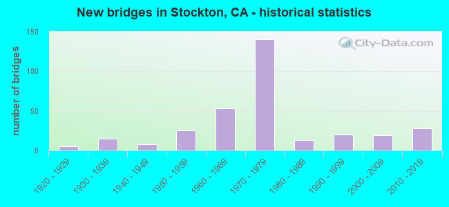
- New bridges - historical statistics
- 11910-1919
- 51920-1929
- 151930-1939
- 81940-1949
- 251950-1959
- 531960-1969
- 1401970-1979
- 131980-1989
- 201990-1999
- 192000-2009
- 282010-2019

- Reconstructed bridges - Historical Statistics
- 21940-1949
- 01950-1959
- 61960-1969
- 41970-1979
- 31980-1989
- 81990-1999
- 92000-2009
- 152010-2019


- Bridge Condition - Deck
- 40.6%Good
- 9.9%Satisfactory
- 36.6%Fair
- 12.9%Poor

- Bridge Condition - Superstructure
- 58.1%Good
- 5.9%Satisfactory
- 26.1%Fair
- 9.9%Poor

- Bridge Condition - Substructure
- 78.8%Good
- 4.4%Satisfactory
- 16.7%Fair

- Bridge Condition - Channel
- 6.9%Excellent
- 22.8%Very good
- 42.1%Good
- 20.7%Satisfactory
- 5.5%Fair
- 1.4%Poor
- 0.7%Serious

- Bridge Condition - Culverts
- 4.0%Very good
- 44.0%Good
- 48.0%Satisfactory
- 4.0%Poor
Find on map >> Show street view
Structure Number: 29 0199L, Location: 10-SJ-005-33.50 (Lat: 38.032386, Lng: -121.364350), Route carried "on" structure: Interstate 5, Year Built: 1975, Status: Open, Structure Length: 4.02m (13.19ft), Average Daily Traffic: 48,000 (year 2009), Truck Traffic: 22%, Average Future Daily Traffic: 81,427 (year 2038), Design Load: HS 20+Mod, Features Intersected: MOSHER SLOUGH
Minimum Vertical Clearance: 30+ m (98+ ft), Kilometerpoint: 33.500, Lanes on structure: 3, Base Highway Network: Yes (, Subroute: 1), Owner: State Highway Agency, Approaching Roadway Width: 15.8m (51.8ft), Skew: 2 degrees, Material/Design: Concrete continuous, Design/Construction: Tee Beam, Number Of Spans In Main Unit: 3, Length of Maximum Span: 13.1m (43.0ft), Curb-To-Curb Width: 15.4m (50.5ft), Out-to-Out Width: 16.6m (54.5ft)
Condition: Deck: Fair, Superstructure: Good, Substructure: Good, Channel: Very good, Operating Rating: 56.7 metric tons, Method Used To Determine Operating Rating: Load and Resistance Factor Rating (LRFR) rating reported by rating factor(RF) method using HL-93 loadings, Inventory Rating: 42.1 metric tons, Method Used To Determine Inventory Rating: Load and Resistance Factor Rating (LRFR) rating reported by rating factor(RF) method using HL-93 loadings, Structural Evaluation: Better than present minimum criteria, Deck Geometry: Somewhat better than minimum adequacy, Waterway Adequacy: Equal to present desirable criteria, Approach Roadway Alignment: Equal to present desirable criteria, Designated Inspection Frequency: Every 24 months, Inspection Date: January 2021, Deck Structure Type: Concrete Cast-file-Place
Find on map >> Show street view
Structure Number: 29 0199R, Location: 10-SJ-005-33.49 (Lat: 38.032392, Lng: -121.363969), Route carried "on" structure: Interstate 5, Year Built: 1975, Status: Open, Structure Length: 4.02m (13.19ft), Average Daily Traffic: 48,000 (year 2009), Truck Traffic: 22%, Average Future Daily Traffic: 81,427 (year 2038), Design Load: HS 20+Mod, Features Intersected: MOSHER SLOUGH
Minimum Vertical Clearance: 30+ m (98+ ft), Kilometerpoint: 33.490, Lanes on structure: 3, Base Highway Network: Yes (, Subroute: 1), Owner: State Highway Agency, Approaching Roadway Width: 15.8m (51.8ft), Skew: 2 degrees, Material/Design: Concrete continuous, Design/Construction: Tee Beam, Number Of Spans In Main Unit: 3, Length of Maximum Span: 13.1m (43.0ft), Curb-To-Curb Width: 15.4m (50.5ft), Out-to-Out Width: 16.6m (54.5ft)
Condition: Deck: Poor, Superstructure: Good, Substructure: Good, Channel: Very good, Operating Rating: 57.7 metric tons, Method Used To Determine Operating Rating: Load and Resistance Factor Rating (LRFR) rating reported by rating factor(RF) method using HL-93 loadings, Inventory Rating: 41.8 metric tons, Method Used To Determine Inventory Rating: Load and Resistance Factor Rating (LRFR) rating reported by rating factor(RF) method using HL-93 loadings, Structural Evaluation: Better than present minimum criteria, Deck Geometry: Somewhat better than minimum adequacy, Waterway Adequacy: Equal to present desirable criteria, Approach Roadway Alignment: Equal to present desirable criteria, Designated Inspection Frequency: Every 24 months, Inspection Date: January 2021, Deck Structure Type: Concrete Cast-file-Place
Find on map >> Show street view
Structure Number: 29 0200L, Location: 10-SJ-005-34.46 (Lat: 38.045911, Lng: -121.369006), Route carried "on" structure: Interstate 5, Year Built: 1975, Status: Open, Structure Length: 2.75m (9.02ft), Average Daily Traffic: 38,500 (year 2009), Truck Traffic: 22%, Average Future Daily Traffic: 78,056 (year 2039), Design Load: HS 20+Mod, Features Intersected: MCAULIFFE RD
Minimum Vertical Clearance: 30+ m (98+ ft), Kilometerpoint: 34.460, Lanes on structure: 3, Lanes under structure: 2, Base Highway Network: Yes (, Subroute: 1), Owner: State Highway Agency, Approaching Roadway Width: 15.4m (50.5ft), Skew: 1 degrees, Material/Design: Concrete continuous, Design/Construction: Tee Beam, Number Of Spans In Main Unit: 3, Length of Maximum Span: 12.2m (40.0ft), Curb-To-Curb Width: 15.4m (50.5ft), Out-to-Out Width: 16.7m (54.8ft)
Condition: Deck: Satisfactory, Superstructure: Good, Substructure: Good, Operating Rating: 42.1 metric tons, Method Used To Determine Operating Rating: Load and Resistance Factor Rating (LRFR) rating reported by rating factor(RF) method using HL-93 loadings, Inventory Rating: 32.7 metric tons, Method Used To Determine Inventory Rating: Load and Resistance Factor Rating (LRFR) rating reported by rating factor(RF) method using HL-93 loadings, Structural Evaluation: Better than present minimum criteria, Deck Geometry: Somewhat better than minimum adequacy, Underclear: High priority of corrective action, Approach Roadway Alignment: Equal to present desirable criteria, Length Of Structure Improvement: 2.75m (9.02ft), Designated Inspection Frequency: Every 24 months, Inspection Date: March 2021, Bridge Improvement Cost: $457,000, Roadway Improvement Cost: $91,000, Total Project Cost: $767,000 ( Estimate for 2020), Deck Structure Type: Concrete Cast-file-Place
Find on map >> Show street view
Structure Number: 29 0200R, Location: 10-SJ-005-34.46 (Lat: 38.045925, Lng: -121.368658), Route carried "on" structure: Interstate 5, Year Built: 1975, Status: Open, Structure Length: 2.74m (8.99ft), Average Daily Traffic: 38,500 (year 2009), Truck Traffic: 22%, Average Future Daily Traffic: 78,056 (year 2039), Design Load: HS 20+Mod, Features Intersected: MCAULIFFE RD
Minimum Vertical Clearance: 30+ m (98+ ft), Kilometerpoint: 34.460, Lanes on structure: 3, Lanes under structure: 2, Base Highway Network: Yes (, Subroute: 1), Owner: State Highway Agency, Approaching Roadway Width: 15.4m (50.5ft), Skew: 1 degrees, Material/Design: Concrete continuous, Design/Construction: Tee Beam, Number Of Spans In Main Unit: 3, Length of Maximum Span: 12.2m (40.0ft), Curb-To-Curb Width: 15.4m (50.5ft), Out-to-Out Width: 16.7m (54.8ft)
Condition: Deck: Fair, Superstructure: Good, Substructure: Good, Operating Rating: 43.1 metric tons, Method Used To Determine Operating Rating: Load and Resistance Factor Rating (LRFR) rating reported by rating factor(RF) method using HL-93 loadings, Inventory Rating: 33.4 metric tons, Method Used To Determine Inventory Rating: Load and Resistance Factor Rating (LRFR) rating reported by rating factor(RF) method using HL-93 loadings, Structural Evaluation: Better than present minimum criteria, Deck Geometry: Somewhat better than minimum adequacy, Underclear: Meets minimum limits, Approach Roadway Alignment: Equal to present desirable criteria, Designated Inspection Frequency: Every 24 months, Inspection Date: March 2021, Deck Structure Type: Concrete Cast-file-Place
Find on map >> Show street view
Structure Number: 29 0202S, Location: 10-SJ-005-27.00-STKN (Lat: 37.956131, Lng: -121.311667), Route carried "on" structure: Ramp Interstate 5, Year Built: 1970, Status: Open, Structure Length: 3.51m (11.52ft), Average Daily Traffic: 9,900 (year 2009), Truck Traffic: 3%, Average Future Daily Traffic: 16,086 (year 2041), Design Load: HS 20, Features Intersected: PARK STREET
Minimum Vertical Clearance: 30+ m (98+ ft), Kilometerpoint: 27.000, Lanes on structure: 1, Lanes under structure: 2, Base Highway Network: Yes (, Subroute: 1), Owner: State Highway Agency, Approaching Roadway Width: 7.3m (24.0ft), Skew: 2 degrees, Material/Design: Prestressed concrete, Design/Construction: Box Beam or Girders - Multiple, Number Of Spans In Main Unit: 1, Length of Maximum Span: 34.7m (113.8ft), Curb-To-Curb Width: 7.3m (24.0ft), Out-to-Out Width: 7.9m (25.9ft)
Condition: Deck: Good, Superstructure: Good, Substructure: Good, Operating Rating: 74.8 metric tons, Method Used To Determine Operating Rating: Load Factor (LF), Inventory Rating: 32.4 metric tons, Method Used To Determine Inventory Rating: Load Factor (LF), Structural Evaluation: Better than present minimum criteria, Deck Geometry: Better than present minimum criteria, Underclear: Equal to present minimum criteria, Approach Roadway Alignment: Equal to present desirable criteria, Designated Inspection Frequency: Every 24 months, Inspection Date: August 2021, Deck Structure Type: Concrete Cast-file-Place
Find on map >> Show street view
Structure Number: 29 0209L, Location: 10-SJ-005-35.30 (Lat: 38.057722, Lng: -121.372722), Route carried "on" structure: Interstate 5, Year Built: 1975, Status: Open, Structure Length: 4.10m (13.45ft), Average Daily Traffic: 38,500 (year 2009), Truck Traffic: 22%, Average Future Daily Traffic: 78,056 (year 2039), Design Load: HS 20+Mod, Features Intersected: EIGHT MILE RD
Minimum Vertical Clearance: 30+ m (98+ ft), Kilometerpoint: 35.300, Lanes on structure: 3, Lanes under structure: 7, Base Highway Network: Yes (, Subroute: 1), Owner: State Highway Agency, Approaching Roadway Width: 15.4m (50.5ft), Skew: 1 degrees, Material/Design: Prestressed concrete, Design/Construction: Box Beam or Girders - Multiple, Number Of Spans In Main Unit: 1, Length of Maximum Span: 40.5m (132.9ft), Curb-To-Curb Width: 15.4m (50.5ft), Out-to-Out Width: 16.7m (54.8ft)
Condition: Deck: Fair, Superstructure: Good, Substructure: Good, Operating Rating: 43.1 metric tons, Method Used To Determine Operating Rating: Load and Resistance Factor Rating (LRFR) rating reported by rating factor(RF) method using HL-93 loadings, Inventory Rating: 30.5 metric tons, Method Used To Determine Inventory Rating: Load and Resistance Factor Rating (LRFR) rating reported by rating factor(RF) method using HL-93 loadings, Structural Evaluation: Better than present minimum criteria, Deck Geometry: Somewhat better than minimum adequacy, Underclear: High priority of corrective action, Approach Roadway Alignment: Equal to present desirable criteria, Designated Inspection Frequency: Every 24 months, Inspection Date: March 2021, Deck Structure Type: Concrete Cast-file-Place
Find on map >> Show street view
Structure Number: 29 0209R, Location: 10-SJ-005-35.30 (Lat: 38.057731, Lng: -121.372364), Route carried "on" structure: Interstate 5, Year Built: 1975, Status: Open, Structure Length: 4.10m (13.45ft), Average Daily Traffic: 38,500 (year 2009), Truck Traffic: 22%, Average Future Daily Traffic: 78,056 (year 2039), Design Load: HS 20+Mod, Features Intersected: EIGHT MILE RD
Minimum Vertical Clearance: 30+ m (98+ ft), Kilometerpoint: 35.300, Lanes on structure: 3, Lanes under structure: 7, Base Highway Network: Yes (, Subroute: 1), Owner: State Highway Agency, Approaching Roadway Width: 15.4m (50.5ft), Skew: 1 degrees, Material/Design: Prestressed concrete, Design/Construction: Box Beam or Girders - Multiple, Number Of Spans In Main Unit: 1, Length of Maximum Span: 40.6m (133.2ft), Curb-To-Curb Width: 15.4m (50.5ft), Out-to-Out Width: 16.7m (54.8ft)
Condition: Deck: Fair, Superstructure: Good, Substructure: Good, Operating Rating: 42.8 metric tons, Method Used To Determine Operating Rating: Load and Resistance Factor Rating (LRFR) rating reported by rating factor(RF) method using HL-93 loadings, Inventory Rating: 30.1 metric tons, Method Used To Determine Inventory Rating: Load and Resistance Factor Rating (LRFR) rating reported by rating factor(RF) method using HL-93 loadings, Structural Evaluation: Better than present minimum criteria, Deck Geometry: Somewhat better than minimum adequacy, Underclear: High priority of corrective action, Approach Roadway Alignment: Equal to present desirable criteria, Designated Inspection Frequency: Every 24 months, Inspection Date: March 2021, Deck Structure Type: Concrete Cast-file-Place
Find on map >> Show street view
Structure Number: 29 021, Location: 10-SJ-005-32.10-STKN (Lat: 38.013736, Lng: -121.355097), Route carried "on" structure: Interstate 5, Year Built: 1970, Year Reconstructed: 2017, Status: Open, Structure Length: 0.85m (2.79ft), Average Daily Traffic: 111,000 (year 2009), Truck Traffic: 17%, Average Future Daily Traffic: 130,582 (year 2038), Design Load: HS 20+Mod, Features Intersected: FIVE MILE SLOUGH
Minimum Vertical Clearance: 30+ m (98+ ft), Kilometerpoint: 32.100, Lanes on structure: 8, Base Highway Network: Yes (, Subroute: 1), Owner: State Highway Agency, Approaching Roadway Width: 49.3m (161.7ft), Skew: 32 degrees, Material/Design: Concrete continuous, Design/Construction: Culvert, Number Of Spans In Main Unit: 2, Length of Maximum Span: 3.9m (12.8ft), Curb-To-Curb Width: 49.3m (161.7ft), Out-to-Out Width: 50.9m (167.0ft)
Condition: Channel: Very good, Culverts: Good, Operating Rating: 54.1 metric tons, Method Used To Determine Operating Rating: Field evaluation and documented engineering judgment, Inventory Rating: 32.4 metric tons, Method Used To Determine Inventory Rating: Field evaluation and documented engineering judgment, Structural Evaluation: Better than present minimum criteria, Deck Geometry: Superior to present desirable criteria, Waterway Adequacy: Equal to present desirable criteria, Approach Roadway Alignment: Equal to present desirable criteria, Designated Inspection Frequency: Every 24 months, Inspection Date: January 2021
Find on map >> Show street view
Structure Number: 29 0212L, Location: 10-SJ-005-32.66-STKN (Lat: 38.021153, Lng: -121.358861), Route carried "on" structure: Interstate 5, Year Built: 1970, Status: Open, Structure Length: 4.40m (14.44ft), Average Daily Traffic: 48,000 (year 2009), Truck Traffic: 22%, Average Future Daily Traffic: 81,427 (year 2038), Design Load: HS 20+Mod, Features Intersected: W HAMMER LANE
Minimum Vertical Clearance: 30+ m (98+ ft), Kilometerpoint: 32.660, Lanes on structure: 3, Lanes under structure: 8, Base Highway Network: Yes (, Subroute: 1), Owner: State Highway Agency, Approaching Roadway Width: 15.5m (50.9ft), Skew: 2 degrees, Material/Design: Prestressed concrete, Design/Construction: Box Beam or Girders - Multiple, Number Of Spans In Main Unit: 1, Length of Maximum Span: 43.3m (142.1ft), Curb-To-Curb Width: 15.5m (50.9ft), Out-to-Out Width: 16.1m (52.8ft)
Condition: Deck: Fair, Superstructure: Good, Substructure: Fair, Operating Rating: 51.2 metric tons, Method Used To Determine Operating Rating: Load and Resistance Factor Rating (LRFR) rating reported by rating factor(RF) method using HL-93 loadings, Inventory Rating: 33.7 metric tons, Method Used To Determine Inventory Rating: Load and Resistance Factor Rating (LRFR) rating reported by rating factor(RF) method using HL-93 loadings, Structural Evaluation: Somewhat better than minimum adequacy, Deck Geometry: Somewhat better than minimum adequacy, Underclear: Equal to present minimum criteria, Approach Roadway Alignment: Equal to present desirable criteria, Designated Inspection Frequency: Every 24 months, Inspection Date: January 2021, Deck Structure Type: Concrete Cast-file-Place
Find on map >> Show street view
Structure Number: 29 0212R, Location: 10-SJ-005-32.66-STKN (Lat: 38.021150, Lng: -121.358453), Route carried "on" structure: Interstate 5, Year Built: 1970, Status: Open, Structure Length: 4.40m (14.44ft), Average Daily Traffic: 48,000 (year 2009), Truck Traffic: 22%, Average Future Daily Traffic: 81,427 (year 2038), Design Load: HS 20+Mod, Features Intersected: W HAMMER LANE
Minimum Vertical Clearance: 30+ m (98+ ft), Kilometerpoint: 32.660, Lanes on structure: 3, Lanes under structure: 8, Base Highway Network: Yes (, Subroute: 1), Owner: State Highway Agency, Approaching Roadway Width: 15.5m (50.9ft), Skew: 2 degrees, Material/Design: Prestressed concrete, Design/Construction: Box Beam or Girders - Multiple, Number Of Spans In Main Unit: 1, Length of Maximum Span: 43.3m (142.1ft), Curb-To-Curb Width: 15.5m (50.9ft), Out-to-Out Width: 16.1m (52.8ft)
Condition: Deck: Fair, Superstructure: Good, Substructure: Good, Operating Rating: 51.2 metric tons, Method Used To Determine Operating Rating: Load and Resistance Factor Rating (LRFR) rating reported by rating factor(RF) method using HL-93 loadings, Inventory Rating: 33.7 metric tons, Method Used To Determine Inventory Rating: Load and Resistance Factor Rating (LRFR) rating reported by rating factor(RF) method using HL-93 loadings, Structural Evaluation: Better than present minimum criteria, Deck Geometry: Somewhat better than minimum adequacy, Underclear: Equal to present minimum criteria, Approach Roadway Alignment: Equal to present desirable criteria, Designated Inspection Frequency: Every 24 months, Inspection Date: January 2021, Deck Structure Type: Concrete Cast-file-Place
Find on map >> Show street view
Structure Number: 29 0215, Location: 10-SJ-005-31.11 (Lat: 37.999936, Lng: -121.349172), Route carried "on" structure: Interstate 5, Year Built: 1970, Year Reconstructed: 2016, Status: Open, Structure Length: 3.17m (10.40ft), Average Daily Traffic: 111,000 (year 2009), Truck Traffic: 23%, Average Future Daily Traffic: 237,000 (year 2038), Design Load: HL 93, Features Intersected: W SWAIN ROAD
Minimum Vertical Clearance: 30+ m (98+ ft), Kilometerpoint: 31.110, Lanes on structure: 8, Lanes under structure: 2, Base Highway Network: Yes (, Subroute: 1), Owner: State Highway Agency, Approaching Roadway Width: 52.9m (173.6ft), Skew: 31 degrees, Material/Design: Prestressed concrete, Design/Construction: Box Beam or Girders - Multiple, Number Of Spans In Main Unit: 1, Length of Maximum Span: 31.1m (102.0ft), Curb-To-Curb Width: 52.9m (173.6ft), Out-to-Out Width: 54.5m (178.8ft)
Condition: Deck: Good, Superstructure: Good, Substructure: Fair, Operating Rating: 42.1 metric tons, Method Used To Determine Operating Rating: Field evaluation and documented engineering judgment, Inventory Rating: 32.4 metric tons, Method Used To Determine Inventory Rating: Field evaluation and documented engineering judgment, Structural Evaluation: Somewhat better than minimum adequacy, Deck Geometry: Superior to present desirable criteria, Underclear: Equal to present minimum criteria, Approach Roadway Alignment: Equal to present desirable criteria, Designated Inspection Frequency: Every 24 months, Inspection Date: January 2021, Deck Structure Type: Concrete Cast-file-Place, Wearing Surface/Protective System: Wearing Surface: Integral Concrete
Find on map >> Show street view
Structure Number: 29 0220L, Location: 10-SJ-005-R22.51 (Lat: 37.896881, Lng: -121.283811), Route carried "on" structure: Interstate 5, Year Built: 1971, Year Reconstructed: 2015, Status: Open, Structure Length: 4.82m (15.81ft), Average Daily Traffic: 87,500 (year 2009), Truck Traffic: 16%, Average Future Daily Traffic: 170,705 (year 2043), Design Load: HS 20+Mod, Features Intersected: FRENCH CAMP ROAD
Minimum Vertical Clearance: 30+ m (98+ ft), Kilometerpoint: 22.510, Lanes on structure: 4, Lanes under structure: 6, Base Highway Network: Yes (, Subroute: 1), Owner: State Highway Agency, Approaching Roadway Width: 23.6m (77.4ft), Skew: 1 degrees, Material/Design: Concrete continuous, Design/Construction: Box Beam or Girders - Multiple, Number Of Spans In Main Unit: 2, Length of Maximum Span: 23.8m (78.1ft), Curb-To-Curb Width: 21.3m (69.9ft), Out-to-Out Width: 22.1m (72.5ft)
Condition: Deck: Good, Superstructure: Good, Substructure: Good, Operating Rating: 98.5 metric tons, Method Used To Determine Operating Rating: Load Factor (LF), Inventory Rating: 59.3 metric tons, Method Used To Determine Inventory Rating: Load Factor (LF), Structural Evaluation: Better than present minimum criteria, Deck Geometry: Better than present minimum criteria, Underclear: Superior to present desirable criteria, Approach Roadway Alignment: Equal to present desirable criteria, Designated Inspection Frequency: Every 24 months, Inspection Date: October 2021, Deck Structure Type: Concrete Cast-file-Place, Wearing Surface/Protective System: Wearing Surface: Integral Concrete
Find on map >> Show street view
Structure Number: 29 0221L, Location: 10-SJ-005-R23.25 (Lat: 37.907406, Lng: -121.287608), Route carried "on" structure: Interstate 5, Year Built: 1971, Year Reconstructed: 2015, Status: Open, Structure Length: 7.04m (23.10ft), Average Daily Traffic: 87,500 (year 2015), Truck Traffic: 16%, Average Future Daily Traffic: 170,705 (year 2043), Design Load: HS 20+Mod, Features Intersected: FRENCH CAMP SLOUGH
Minimum Vertical Clearance: 30+ m (98+ ft), Kilometerpoint: 23.250, Lanes on structure: 3, Base Highway Network: Yes (, Subroute: 1), Owner: State Highway Agency, Approaching Roadway Width: 15.5m (50.9ft), Skew: 5 degrees, Material/Design: Concrete continuous, Design/Construction: Slab, Number Of Spans In Main Unit: 7, Length of Maximum Span: 10.4m (34.1ft), Curb-To-Curb Width: 19.1m (62.7ft), Out-to-Out Width: 19.7m (64.6ft)
Condition: Deck: Fair, Superstructure: Fair, Substructure: Fair, Channel: Good, Operating Rating: 70.3 metric tons, Method Used To Determine Operating Rating: Load Factor (LF), Inventory Rating: 42.4 metric tons, Method Used To Determine Inventory Rating: Load Factor (LF), Structural Evaluation: Somewhat better than minimum adequacy, Deck Geometry: Superior to present desirable criteria, Waterway Adequacy: Equal to present desirable criteria, Approach Roadway Alignment: Equal to present desirable criteria, Designated Inspection Frequency: Every 24 months, Underwater Inspection Frequency: Every 60 months, Inspection Date: October 2021, Underwater Inspection Date: September 2019, Deck Structure Type: Concrete Cast-file-Place
Find on map >> Show street view
Structure Number: 29 0221R, Location: 10-SJ-005-R23.25 (Lat: 37.907161, Lng: -121.287161), Route carried "on" structure: Interstate 5, Year Built: 1971, Year Reconstructed: 2013, Status: Open, Structure Length: 7.04m (23.10ft), Average Daily Traffic: 43,750 (year 2009), Truck Traffic: 24%, Average Future Daily Traffic: 85,351 (year 2043), Design Load: HS 20+Mod, Features Intersected: FRENCH CAMP SLOUGH
Minimum Vertical Clearance: 30+ m (98+ ft), Kilometerpoint: 23.250, Lanes on structure: 4, Base Highway Network: Yes (, Subroute: 1), Owner: State Highway Agency, Approaching Roadway Width: 19.3m (63.3ft), Skew: 5 degrees, Material/Design: Concrete continuous, Design/Construction: Slab, Number Of Spans In Main Unit: 7, Length of Maximum Span: 10.4m (34.1ft), Curb-To-Curb Width: 19.3m (63.3ft), Out-to-Out Width: 20.0m (65.6ft)
Condition: Deck: Fair, Superstructure: Fair, Substructure: Fair, Channel: Good, Operating Rating: 70.3 metric tons, Method Used To Determine Operating Rating: Load Factor (LF), Inventory Rating: 42.4 metric tons, Method Used To Determine Inventory Rating: Load Factor (LF), Structural Evaluation: Somewhat better than minimum adequacy, Deck Geometry: Somewhat better than minimum adequacy, Waterway Adequacy: Equal to present desirable criteria, Approach Roadway Alignment: Equal to present desirable criteria, Designated Inspection Frequency: Every 24 months, Underwater Inspection Frequency: Every 60 months, Inspection Date: October 2021, Underwater Inspection Date: September 2019, Deck Structure Type: Concrete Cast-file-Place
Find on map >> Show street view
Structure Number: 29 0222L, Location: 10-SJ-005-R23.66 (Lat: 37.912875, Lng: -121.289581), Route carried "on" structure: Interstate 5, Year Built: 1971, Status: Open, Structure Length: 3.87m (12.70ft), Average Daily Traffic: 43,750 (year 2015), Truck Traffic: 24%, Average Future Daily Traffic: 85,351 (year 2043), Design Load: HS 20, Features Intersected: DOWNING AVENUE
Minimum Vertical Clearance: 30+ m (98+ ft), Kilometerpoint: 23.660, Lanes on structure: 3, Lanes under structure: 6, Base Highway Network: Yes (, Subroute: 1), Owner: State Highway Agency, Approaching Roadway Width: 15.5m (50.9ft), Material/Design: Prestressed concrete, Design/Construction: Box Beam or Girders - Multiple, Number Of Spans In Main Unit: 1, Length of Maximum Span: 38.4m (126.0ft), Curb-To-Curb Width: 15.5m (50.9ft), Out-to-Out Width: 16.2m (53.1ft)
Condition: Deck: Fair, Superstructure: Fair, Substructure: Good, Operating Rating: 29.8 metric tons, Method Used To Determine Operating Rating: Load and Resistance Factor Rating (LRFR) rating reported by rating factor(RF) method using HL-93 loadings, Inventory Rating: 22.4 metric tons, Method Used To Determine Inventory Rating: Load and Resistance Factor Rating (LRFR) rating reported by rating factor(RF) method using HL-93 loadings, Structural Evaluation: Somewhat better than minimum adequacy, Deck Geometry: Somewhat better than minimum adequacy, Underclear: Equal to present minimum criteria, Approach Roadway Alignment: Equal to present desirable criteria, Designated Inspection Frequency: Every 24 months, Inspection Date: October 2021, Deck Structure Type: Concrete Cast-file-Place
Find on map >> Show street view
Structure Number: 29 0222R, Location: 10-SJ-005-R23.66 (Lat: 37.912914, Lng: -121.289233), Route carried "on" structure: Interstate 5, Year Built: 1971, Status: Open, Structure Length: 3.87m (12.70ft), Average Daily Traffic: 43,750 (year 2015), Truck Traffic: 24%, Average Future Daily Traffic: 85,351 (year 2043), Design Load: HS 20, Features Intersected: DOWNING AVENUE
Minimum Vertical Clearance: 30+ m (98+ ft), Kilometerpoint: 23.660, Lanes on structure: 3, Lanes under structure: 6, Base Highway Network: Yes (, Subroute: 1), Owner: State Highway Agency, Approaching Roadway Width: 15.5m (50.9ft), Material/Design: Prestressed concrete, Design/Construction: Box Beam or Girders - Multiple, Number Of Spans In Main Unit: 1, Length of Maximum Span: 38.4m (126.0ft), Curb-To-Curb Width: 15.5m (50.9ft), Out-to-Out Width: 16.2m (53.1ft)
Condition: Deck: Fair, Superstructure: Fair, Substructure: Fair, Operating Rating: 42.8 metric tons, Method Used To Determine Operating Rating: Load and Resistance Factor Rating (LRFR) rating reported by rating factor(RF) method using HL-93 loadings, Inventory Rating: 32.1 metric tons, Method Used To Determine Inventory Rating: Load and Resistance Factor Rating (LRFR) rating reported by rating factor(RF) method using HL-93 loadings, Structural Evaluation: Somewhat better than minimum adequacy, Deck Geometry: Somewhat better than minimum adequacy, Underclear: Better than present minimum criteria, Approach Roadway Alignment: Equal to present desirable criteria, Designated Inspection Frequency: Every 24 months, Inspection Date: October 2021, Deck Structure Type: Concrete Cast-file-Place
Find on map >> Show street view
Structure Number: 29 0223L, Location: 10-SJ-005-R23.93-STKN (Lat: 37.916728, Lng: -121.290969), Route carried "on" structure: Interstate 5, Year Built: 1971, Status: Open, Structure Length: 3.60m (11.81ft), Average Daily Traffic: 43,750 (year 2015), Truck Traffic: 24%, Average Future Daily Traffic: 84,785 (year 2043), Design Load: HS 20+Mod, Features Intersected: WALKER SLOUGH
Minimum Vertical Clearance: 30+ m (98+ ft), Kilometerpoint: 23.930, Lanes on structure: 3, Base Highway Network: Yes (, Subroute: 1), Owner: State Highway Agency, Approaching Roadway Width: 15.5m (50.9ft), Skew: 1 degrees, Material/Design: Concrete continuous, Design/Construction: Slab, Number Of Spans In Main Unit: 5, Length of Maximum Span: 7.9m (25.9ft), Curb-To-Curb Width: 15.5m (50.9ft), Out-to-Out Width: 16.2m (53.1ft)
Condition: Deck: Poor, Superstructure: Poor, Substructure: Good, Channel: Very good, Operating Rating: 55.7 metric tons, Method Used To Determine Operating Rating: Load Factor (LF), Inventory Rating: 33.4 metric tons, Method Used To Determine Inventory Rating: Load Factor (LF), Structural Evaluation: Meets minimum limits, Deck Geometry: Somewhat better than minimum adequacy, Waterway Adequacy: Equal to present desirable criteria, Approach Roadway Alignment: Equal to present desirable criteria, Length Of Structure Improvement: 3.60m (11.81ft), Designated Inspection Frequency: Every 24 months, Inspection Date: October 2021, Bridge Improvement Cost: $581,000, Roadway Improvement Cost: $116,000, Total Project Cost: $976,000 ( Estimate for 2020), Deck Structure Type: Concrete Cast-file-Place
Find on map >> Show street view
Structure Number: 29 0223R, Location: 10-SJ-005-R23.93-STKN (Lat: 37.916742, Lng: -121.290572), Route carried "on" structure: Interstate 5, Year Built: 1971, Status: Open, Structure Length: 3.60m (11.81ft), Average Daily Traffic: 43,750 (year 2009), Truck Traffic: 24%, Average Future Daily Traffic: 85,351 (year 2043), Features Intersected: WALKER SLOUGH
Minimum Vertical Clearance: 30+ m (98+ ft), Kilometerpoint: 23.930, Lanes on structure: 4, Base Highway Network: Yes (, Subroute: 1), Owner: State Highway Agency, Approaching Roadway Width: 19.5m (64.0ft), Skew: 1 degrees, Material/Design: Concrete continuous, Design/Construction: Slab, Number Of Spans In Main Unit: 5, Length of Maximum Span: 7.9m (25.9ft), Curb-To-Curb Width: 18.6m (61.0ft), Out-to-Out Width: 19.2m (63.0ft)
Condition: Deck: Fair, Superstructure: Fair, Substructure: Good, Channel: Very good, Operating Rating: 55.7 metric tons, Method Used To Determine Operating Rating: Load Factor (LF), Inventory Rating: 33.4 metric tons, Method Used To Determine Inventory Rating: Load Factor (LF), Structural Evaluation: Somewhat better than minimum adequacy, Deck Geometry: Meets minimum limits, Waterway Adequacy: Equal to present desirable criteria, Approach Roadway Alignment: Equal to present desirable criteria, Designated Inspection Frequency: Every 24 months, Inspection Date: October 2021, Deck Structure Type: Concrete Cast-file-Place
Find on map >> Show street view
Structure Number: 29 0224L, Location: 10-SJ-005-24.64-STKN (Lat: 37.926544, Lng: -121.294511), Route carried "on" structure: Interstate 5, Year Built: 1971, Status: Open, Structure Length: 4.15m (13.62ft), Average Daily Traffic: 41,050 (year 2009), Truck Traffic: 16%, Average Future Daily Traffic: 109,692 (year 2041), Design Load: HS 20+Mod, Features Intersected: EIGHTH STREET
Minimum Vertical Clearance: 30+ m (98+ ft), Kilometerpoint: 24.640, Lanes on structure: 3, Lanes under structure: 4, Base Highway Network: Yes (, Subroute: 1), Owner: State Highway Agency, Approaching Roadway Width: 15.5m (50.9ft), Skew: 1 degrees, Material/Design: Prestressed concrete, Design/Construction: Box Beam or Girders - Multiple, Number Of Spans In Main Unit: 1, Length of Maximum Span: 40.8m (133.9ft), Curb-To-Curb Width: 15.5m (50.9ft), Out-to-Out Width: 16.2m (53.1ft)
Condition: Deck: Fair, Superstructure: Good, Substructure: Good, Operating Rating: 30.1 metric tons, Method Used To Determine Operating Rating: Load and Resistance Factor Rating (LRFR) rating reported by rating factor(RF) method using HL-93 loadings, Inventory Rating: 22.7 metric tons, Method Used To Determine Inventory Rating: Load and Resistance Factor Rating (LRFR) rating reported by rating factor(RF) method using HL-93 loadings, Structural Evaluation: Somewhat better than minimum adequacy, Deck Geometry: Somewhat better than minimum adequacy, Underclear: Equal to present minimum criteria, Approach Roadway Alignment: Equal to present desirable criteria, Designated Inspection Frequency: Every 24 months, Inspection Date: August 2021, Deck Structure Type: Concrete Cast-file-Place
Find on map >> Show street view
Structure Number: 29 0224R, Location: 10-SJ-005-24.64-STKN (Lat: 37.926583, Lng: -121.294164), Route carried "on" structure: Interstate 5, Year Built: 1971, Status: Open, Structure Length: 4.24m (13.91ft), Average Daily Traffic: 43,750 (year 2009), Truck Traffic: 24%, Average Future Daily Traffic: 83,109 (year 2041), Design Load: HS 20+Mod, Features Intersected: EIGHTH STREET
Minimum Vertical Clearance: 30+ m (98+ ft), Kilometerpoint: 24.640, Lanes on structure: 3, Lanes under structure: 5, Base Highway Network: Yes (, Subroute: 1), Owner: State Highway Agency, Approaching Roadway Width: 15.5m (50.9ft), Material/Design: Prestressed concrete, Design/Construction: Box Beam or Girders - Multiple, Number Of Spans In Main Unit: 1, Length of Maximum Span: 41.8m (137.1ft), Curb-To-Curb Width: 15.5m (50.9ft), Out-to-Out Width: 16.2m (53.1ft)
Condition: Deck: Fair, Superstructure: Good, Substructure: Satisfactory, Operating Rating: 53.1 metric tons, Method Used To Determine Operating Rating: Load and Resistance Factor Rating (LRFR) rating reported by rating factor(RF) method using HL-93 loadings, Inventory Rating: 40.2 metric tons, Method Used To Determine Inventory Rating: Load and Resistance Factor Rating (LRFR) rating reported by rating factor(RF) method using HL-93 loadings, Structural Evaluation: Equal to present minimum criteria, Deck Geometry: Somewhat better than minimum adequacy, Underclear: Equal to present minimum criteria, Approach Roadway Alignment: Equal to present desirable criteria, Designated Inspection Frequency: Every 24 months, Inspection Date: August 2021, Deck Structure Type: Concrete Cast-file-Place
Find on map >> Show street view
Structure Number: 29 0225L, Location: 10-SJ-005-25.35-STKN (Lat: 37.936572, Lng: -121.297544), Route carried "on" structure: Interstate 5, Year Built: 1971, Status: Open, Structure Length: 4.57m (14.99ft), Average Daily Traffic: 61,050 (year 2009), Truck Traffic: 16%, Average Future Daily Traffic: 109,692 (year 2041), Design Load: HS 20+Mod, Features Intersected: STATE RTE 4 (CHARTER WY)
Minimum Vertical Clearance: 30+ m (98+ ft), Kilometerpoint: 25.350, Lanes on structure: 4, Lanes under structure: 6, Base Highway Network: Yes (, Subroute: 1), Owner: State Highway Agency, Approaching Roadway Width: 20.1m (65.9ft), Skew: 1 degrees, Material/Design: Prestressed concrete, Design/Construction: Box Beam or Girders - Multiple, Number Of Spans In Main Unit: 1, Length of Maximum Span: 45.1m (148.0ft), Curb-To-Curb Width: 20.1m (65.9ft), Out-to-Out Width: 20.7m (67.9ft)
Condition: Deck: Satisfactory, Superstructure: Good, Substructure: Good, Operating Rating: 31.4 metric tons, Method Used To Determine Operating Rating: Load and Resistance Factor Rating (LRFR) rating reported by rating factor(RF) method using HL-93 loadings, Inventory Rating: 23.7 metric tons, Method Used To Determine Inventory Rating: Load and Resistance Factor Rating (LRFR) rating reported by rating factor(RF) method using HL-93 loadings, Structural Evaluation: Somewhat better than minimum adequacy, Deck Geometry: Equal to present minimum criteria, Underclear: High priority of corrective action, Approach Roadway Alignment: Equal to present desirable criteria, Designated Inspection Frequency: Every 24 months, Inspection Date: August 2021, Deck Structure Type: Concrete Cast-file-Place
Find on map >> Show street view
Structure Number: 29 0225R, Location: 10-SJ-005-25.35-STKN (Lat: 37.936647, Lng: -121.297258), Route carried "on" structure: Interstate 5, Year Built: 1971, Status: Open, Structure Length: 4.60m (15.09ft), Average Daily Traffic: 63,750 (year 2009), Truck Traffic: 24%, Average Future Daily Traffic: 83,109 (year 2041), Design Load: HS 20+Mod, Features Intersected: STATE RTE 4 (CHARTER WY)
Minimum Vertical Clearance: 30+ m (98+ ft), Kilometerpoint: 25.350, Lanes on structure: 4, Lanes under structure: 6, Base Highway Network: Yes (, Subroute: 1), Owner: State Highway Agency, Approaching Roadway Width: 20.1m (65.9ft), Skew: 1 degrees, Material/Design: Prestressed concrete, Design/Construction: Box Beam or Girders - Multiple, Number Of Spans In Main Unit: 1, Length of Maximum Span: 45.4m (149.0ft), Curb-To-Curb Width: 20.1m (65.9ft), Out-to-Out Width: 20.7m (67.9ft)
Condition: Deck: Satisfactory, Superstructure: Good, Substructure: Good, Operating Rating: 50.9 metric tons, Method Used To Determine Operating Rating: Load and Resistance Factor Rating (LRFR) rating reported by rating factor(RF) method using HL-93 loadings, Inventory Rating: 38.6 metric tons, Method Used To Determine Inventory Rating: Load and Resistance Factor Rating (LRFR) rating reported by rating factor(RF) method using HL-93 loadings, Structural Evaluation: Better than present minimum criteria, Deck Geometry: Equal to present minimum criteria, Underclear: High priority of corrective action, Approach Roadway Alignment: Equal to present desirable criteria, Designated Inspection Frequency: Every 24 months, Inspection Date: August 2021, Deck Structure Type: Concrete Cast-file-Place
Find on map >> Show street view
Structure Number: 29 0226, Location: 10-SJ-005-29.83 (Lat: 37.982347, Lng: -121.342258), Route carried "on" structure: Interstate 5, Year Built: 1970, Year Reconstructed: 2016, Status: Open, Structure Length: 7.56m (24.80ft), Average Daily Traffic: 124,000 (year 2009), Truck Traffic: 23%, Average Future Daily Traffic: 237,000 (year 2038), Design Load: HL 93, Features Intersected: EBMUD AQUEDUCT
Minimum Vertical Clearance: 30+ m (98+ ft), Kilometerpoint: 29.830, Lanes on structure: 8, Base Highway Network: Yes (, Subroute: 1), Owner: State Highway Agency, Approaching Roadway Width: 50.7m (166.3ft), Skew: 31 degrees, Material/Design: Concrete continuous, Design/Construction: Box Beam or Girders - Multiple, Number Of Spans In Main Unit: 4, Length of Maximum Span: 26.8m (87.9ft), Curb-To-Curb Width: 50.7m (166.3ft), Out-to-Out Width: 52.1m (170.9ft)
Condition: Deck: Good, Superstructure: Fair, Substructure: Good, Operating Rating: 42.1 metric tons, Method Used To Determine Operating Rating: Field evaluation and documented engineering judgment, Inventory Rating: 32.4 metric tons, Method Used To Determine Inventory Rating: Field evaluation and documented engineering judgment, Structural Evaluation: Somewhat better than minimum adequacy, Deck Geometry: Superior to present desirable criteria, Approach Roadway Alignment: Equal to present desirable criteria, Designated Inspection Frequency: Every 24 months, Inspection Date: January 2021, Deck Structure Type: Concrete Cast-file-Place, Wearing Surface/Protective System: Wearing Surface: Integral Concrete
Find on map >> Show street view
Structure Number: 29 0226S, Location: 10-SJ-005-29.83 (Lat: 37.982433, Lng: -121.342017), Route carried "on" structure: Ramp Interstate 5, Year Built: 1970, Year Reconstructed: 1997, Status: Open, Structure Length: 7.80m (25.59ft), Average Daily Traffic: 10,800 (year 1998), Truck Traffic: 6%, Average Future Daily Traffic: 21,808 (year 2041), Design Load: HS 20+Mod, Features Intersected: EBMUD AQUEDUCT
Minimum Vertical Clearance: 30+ m (98+ ft), Kilometerpoint: 29.830, Lanes on structure: 3, Owner: State Highway Agency, Approaching Roadway Width: 14.8m (48.6ft), Skew: 1 degrees, Material/Design: Concrete continuous, Design/Construction: Box Beam or Girders - Multiple, Number Of Spans In Main Unit: 4, Length of Maximum Span: 27.7m (90.9ft), Curb-To-Curb Width: 14.8m (48.6ft), Out-to-Out Width: 15.9m (52.2ft)
Condition: Deck: Fair, Superstructure: Good, Substructure: Good, Operating Rating: 54.1 metric tons, Method Used To Determine Operating Rating: Field evaluation and documented engineering judgment, Inventory Rating: 32.4 metric tons, Method Used To Determine Inventory Rating: Field evaluation and documented engineering judgment, Structural Evaluation: Better than present minimum criteria, Deck Geometry: Equal to present desirable criteria, Approach Roadway Alignment: Equal to present desirable criteria, Designated Inspection Frequency: Every 24 months, Inspection Date: January 2021, Deck Structure Type: Concrete Cast-file-Place
Find on map >> Show street view
Structure Number: 29 0229L, Location: 10-SJ-005-25.64-STKN (Lat: 37.940758, Lng: -121.298239), Route carried "on" structure: Interstate 5, Year Built: 1971, Status: Open, Structure Length: 3.35m (10.99ft), Average Daily Traffic: 87,500 (year 2009), Truck Traffic: 16%, Average Future Daily Traffic: 166,220 (year 2041), Design Load: HS 20+Mod, Features Intersected: ANDERSON STREET
Minimum Vertical Clearance: 30+ m (98+ ft), Kilometerpoint: 25.640, Lanes on structure: 5, Lanes under structure: 2, Base Highway Network: Yes (, Subroute: 1), Owner: State Highway Agency, Approaching Roadway Width: 23.8m (78.1ft), Material/Design: Prestressed concrete, Design/Construction: Box Beam or Girders - Multiple, Number Of Spans In Main Unit: 1, Length of Maximum Span: 33.5m (109.9ft), Curb-To-Curb Width: 23.8m (78.1ft), Out-to-Out Width: 24.4m (80.1ft)
Condition: Deck: Fair, Superstructure: Good, Substructure: Good, Operating Rating: 39.9 metric tons, Method Used To Determine Operating Rating: Load and Resistance Factor Rating (LRFR) rating reported by rating factor(RF) method using HL-93 loadings, Inventory Rating: 30.8 metric tons, Method Used To Determine Inventory Rating: Load and Resistance Factor Rating (LRFR) rating reported by rating factor(RF) method using HL-93 loadings, Structural Evaluation: Better than present minimum criteria, Deck Geometry: Equal to present minimum criteria, Underclear: Better than present minimum criteria, Approach Roadway Alignment: Equal to present desirable criteria, Designated Inspection Frequency: Every 24 months, Inspection Date: August 2021, Deck Structure Type: Concrete Cast-file-Place
Find on map >> Show street view
Structure Number: 29 0229R, Location: 10-SJ-005-25.64-STKN (Lat: 37.940811, Lng: -121.297908), Route carried "on" structure: Interstate 5, Year Built: 1971, Status: Open, Structure Length: 3.35m (10.99ft), Average Daily Traffic: 43,750 (year 2009), Truck Traffic: 24%, Average Future Daily Traffic: 83,109 (year 2041), Design Load: HS 20+Mod, Features Intersected: ANDERSON STREET
Minimum Vertical Clearance: 30+ m (98+ ft), Kilometerpoint: 25.640, Lanes on structure: 5, Lanes under structure: 2, Base Highway Network: Yes (, Subroute: 1), Owner: State Highway Agency, Approaching Roadway Width: 23.8m (78.1ft), Material/Design: Prestressed concrete, Design/Construction: Box Beam or Girders - Multiple, Number Of Spans In Main Unit: 1, Length of Maximum Span: 33.5m (109.9ft), Curb-To-Curb Width: 23.8m (78.1ft), Out-to-Out Width: 24.4m (80.1ft)
Condition: Deck: Fair, Superstructure: Good, Substructure: Good, Operating Rating: 39.9 metric tons, Method Used To Determine Operating Rating: Load and Resistance Factor Rating (LRFR) rating reported by rating factor(RF) method using HL-93 loadings, Inventory Rating: 30.8 metric tons, Method Used To Determine Inventory Rating: Load and Resistance Factor Rating (LRFR) rating reported by rating factor(RF) method using HL-93 loadings, Structural Evaluation: Better than present minimum criteria, Deck Geometry: Equal to present minimum criteria, Underclear: Better than present minimum criteria, Approach Roadway Alignment: Equal to present desirable criteria, Designated Inspection Frequency: Every 24 months, Inspection Date: August 2021, Deck Structure Type: Concrete Cast-file-Place
Find on map >> Show street view
Structure Number: 29 0230L, Location: 10-SJ-005-25.78-STKN (Lat: 37.942728, Lng: -121.298564), Route carried "on" structure: Interstate 5, Year Built: 1972, Status: Open, Structure Length: 4.30m (14.11ft), Average Daily Traffic: 87,500 (year 2009), Truck Traffic: 16%, Average Future Daily Traffic: 166,220 (year 2041), Design Load: HS 20+Mod, Features Intersected: BNSF RY & AMTRAK
Minimum Vertical Clearance: 30+ m (98+ ft), Kilometerpoint: 25.780, Lanes on structure: 6, Base Highway Network: Yes (, Subroute: 1), Owner: State Highway Agency, Approaching Roadway Width: 28.3m (92.8ft), Material/Design: Prestressed concrete, Design/Construction: Box Beam or Girders - Multiple, Number Of Spans In Main Unit: 1, Length of Maximum Span: 43.0m (141.1ft), Curb-To-Curb Width: 27.7m (90.9ft), Out-to-Out Width: 28.4m (93.2ft)
Condition: Deck: Fair, Superstructure: Good, Substructure: Good, Operating Rating: 55.1 metric tons, Method Used To Determine Operating Rating: Load and Resistance Factor Rating (LRFR) rating reported by rating factor(RF) method using HL-93 loadings, Inventory Rating: 36.6 metric tons, Method Used To Determine Inventory Rating: Load and Resistance Factor Rating (LRFR) rating reported by rating factor(RF) method using HL-93 loadings, Structural Evaluation: Better than present minimum criteria, Deck Geometry: Equal to present minimum criteria, Underclear: Better than present minimum criteria, Approach Roadway Alignment: Equal to present desirable criteria, Designated Inspection Frequency: Every 24 months, Inspection Date: August 2021, Deck Structure Type: Concrete Cast-file-Place
Find on map >> Show street view
Structure Number: 29 0230R, Location: 10-SJ-005-25.78-STKN (Lat: 37.942800, Lng: -121.298158), Route carried "on" structure: Interstate 5, Year Built: 1972, Status: Open, Structure Length: 4.30m (14.11ft), Average Daily Traffic: 43,750 (year 2009), Truck Traffic: 24%, Average Future Daily Traffic: 83,109 (year 2041), Design Load: HS 20+Mod, Features Intersected: BNSF RY & AMTRAK
Minimum Vertical Clearance: 30+ m (98+ ft), Kilometerpoint: 25.780, Lanes on structure: 6, Base Highway Network: Yes (, Subroute: 1), Owner: State Highway Agency, Approaching Roadway Width: 30.5m (100.1ft), Material/Design: Prestressed concrete, Design/Construction: Box Beam or Girders - Multiple, Number Of Spans In Main Unit: 1, Length of Maximum Span: 43.0m (141.1ft), Curb-To-Curb Width: 30.5m (100.1ft), Out-to-Out Width: 31.1m (102.0ft)
Condition: Deck: Fair, Superstructure: Satisfactory, Substructure: Good, Operating Rating: 55.7 metric tons, Method Used To Determine Operating Rating: Load and Resistance Factor Rating (LRFR) rating reported by rating factor(RF) method using HL-93 loadings, Inventory Rating: 37.3 metric tons, Method Used To Determine Inventory Rating: Load and Resistance Factor Rating (LRFR) rating reported by rating factor(RF) method using HL-93 loadings, Structural Evaluation: Equal to present minimum criteria, Deck Geometry: Superior to present desirable criteria, Underclear: Better than present minimum criteria, Approach Roadway Alignment: Equal to present desirable criteria, Designated Inspection Frequency: Every 24 months, Inspection Date: August 2021, Deck Structure Type: Concrete Cast-file-Place
Find on map >> Show street view
Structure Number: 29 0231H, Location: 10-SJ-004-R16.00-STKN (Lat: 37.945978, Lng: -121.300136), Route carried "on" structure: Ramp State highway 4, Year Built: 1972, Status: Open, Structure Length: 3.29m (10.79ft), Average Daily Traffic: 19,400 (year 2000), Truck Traffic: 8%, Average Future Daily Traffic: 31,311 (year 2041), Design Load: HS 20+Mod, Features Intersected: CHURCH STREET
Minimum Vertical Clearance: 30+ m (98+ ft), Kilometerpoint: 16.000, Lanes on structure: 3, Lanes under structure: 2, Base Highway Network: Yes (, Subroute: 1), Owner: State Highway Agency, Approaching Roadway Width: 17.4m (57.1ft), Skew: 1 degrees, Material/Design: Prestressed concrete, Design/Construction: Box Beam or Girders - Multiple, Number Of Spans In Main Unit: 1, Length of Maximum Span: 32.0m (105.0ft), Curb-To-Curb Width: 16.6m (54.5ft), Out-to-Out Width: 17.2m (56.4ft)
Condition: Deck: Satisfactory, Superstructure: Good, Substructure: Fair, Operating Rating: 51.5 metric tons, Method Used To Determine Operating Rating: Load and Resistance Factor Rating (LRFR) rating reported by rating factor(RF) method using HL-93 loadings, Inventory Rating: 38.2 metric tons, Method Used To Determine Inventory Rating: Load and Resistance Factor Rating (LRFR) rating reported by rating factor(RF) method using HL-93 loadings, Structural Evaluation: Somewhat better than minimum adequacy, Deck Geometry: Superior to present desirable criteria, Underclear: Somewhat better than minimum adequacy, Approach Roadway Alignment: Equal to present desirable criteria, Designated Inspection Frequency: Every 24 months, Inspection Date: June 2021, Deck Structure Type: Concrete Cast-file-Place
Find on map >> Show street view
Structure Number: 29 0231L, Location: 10-SJ-005-25.99-STKN (Lat: 37.945758, Lng: -121.299175), Route carried "on" structure: Interstate 5, Year Built: 1972, Status: Open, Structure Length: 5.21m (17.09ft), Average Daily Traffic: 87,500 (year 2009), Truck Traffic: 16%, Average Future Daily Traffic: 166,220 (year 2041), Design Load: HS 20+Mod, Features Intersected: CHURCH STREET
Minimum Vertical Clearance: 30+ m (98+ ft), Kilometerpoint: 25.990, Lanes on structure: 4, Lanes under structure: 2, Base Highway Network: Yes (, Subroute: 1), Owner: State Highway Agency, Approaching Roadway Width: 20.4m (66.9ft), Material/Design: Prestressed concrete, Design/Construction: Box Beam or Girders - Multiple, Number Of Spans In Main Unit: 1, Length of Maximum Span: 51.2m (168.0ft), Curb-To-Curb Width: 20.1m (65.9ft), Out-to-Out Width: 20.7m (67.9ft)
Condition: Deck: Fair, Superstructure: Good, Substructure: Good, Operating Rating: 58.6 metric tons, Method Used To Determine Operating Rating: Load and Resistance Factor Rating (LRFR) rating reported by rating factor(RF) method using HL-93 loadings, Inventory Rating: 36.0 metric tons, Method Used To Determine Inventory Rating: Load and Resistance Factor Rating (LRFR) rating reported by rating factor(RF) method using HL-93 loadings, Structural Evaluation: Better than present minimum criteria, Deck Geometry: Equal to present minimum criteria, Underclear: Equal to present minimum criteria, Approach Roadway Alignment: Equal to present desirable criteria, Designated Inspection Frequency: Every 24 months, Inspection Date: August 2021, Deck Structure Type: Concrete Cast-file-Place
Find on map >> Show street view
Structure Number: 29 0231R, Location: 10-SJ-005-25.99-STKN (Lat: 37.945803, Lng: -121.298883), Route carried "on" structure: Interstate 5, Year Built: 1972, Status: Open, Structure Length: 5.15m (16.90ft), Average Daily Traffic: 43,750 (year 2009), Truck Traffic: 24%, Average Future Daily Traffic: 83,109 (year 2041), Design Load: HS 20+Mod, Features Intersected: CHURCH STREET
Minimum Vertical Clearance: 30+ m (98+ ft), Kilometerpoint: 25.990, Lanes on structure: 4, Lanes under structure: 2, Base Highway Network: Yes (, Subroute: 1), Owner: State Highway Agency, Approaching Roadway Width: 20.4m (66.9ft), Material/Design: Prestressed concrete, Design/Construction: Box Beam or Girders - Multiple, Number Of Spans In Main Unit: 1, Length of Maximum Span: 50.6m (166.0ft), Curb-To-Curb Width: 20.1m (65.9ft), Out-to-Out Width: 20.7m (67.9ft)
Condition: Deck: Satisfactory, Superstructure: Good, Substructure: Satisfactory, Operating Rating: 58.6 metric tons, Method Used To Determine Operating Rating: Load and Resistance Factor Rating (LRFR) rating reported by rating factor(RF) method using HL-93 loadings, Inventory Rating: 36.0 metric tons, Method Used To Determine Inventory Rating: Load and Resistance Factor Rating (LRFR) rating reported by rating factor(RF) method using HL-93 loadings, Structural Evaluation: Equal to present minimum criteria, Deck Geometry: Equal to present minimum criteria, Underclear: Equal to present minimum criteria, Approach Roadway Alignment: Equal to present desirable criteria, Designated Inspection Frequency: Every 24 months, Inspection Date: August 2021, Deck Structure Type: Concrete Cast-file-Place
Find on map >> Show street view
Structure Number: 29 0232L, Location: 10-SJ-005-26.12-STKN (Lat: 37.947503, Lng: -121.300081), Route carried "on" structure: Interstate 5, Year Built: 1972, Status: Open, Structure Length: 22.49m (73.79ft), Average Daily Traffic: 87,500 (year 2009), Truck Traffic: 16%, Average Future Daily Traffic: 166,220 (year 2041), Design Load: HS 20+Mod, Features Intersected: STATE ROUTE 4
Minimum Vertical Clearance: 5.38m (17.65ft), Kilometerpoint: 26.120, Lanes on structure: 4, Lanes under structure: 9, Base Highway Network: Yes (, Subroute: 1), Owner: State Highway Agency, Approaching Roadway Width: 20.1m (65.9ft), Skew: 3 degrees, Material/Design: Concrete continuous, Design/Construction: Box Beam or Girders - Multiple, Number Of Spans In Main Unit: 6, Length of Maximum Span: 47.2m (154.9ft), Curb-To-Curb Width: 20.1m (65.9ft), Out-to-Out Width: 20.7m (67.9ft)
Condition: Deck: Fair, Superstructure: Good, Substructure: Good, Operating Rating: 98.5 metric tons, Method Used To Determine Operating Rating: Load Factor (LF), Inventory Rating: 59.0 metric tons, Method Used To Determine Inventory Rating: Load Factor (LF), Structural Evaluation: Better than present minimum criteria, Deck Geometry: Equal to present minimum criteria, Underclear: High priority of corrective action, Approach Roadway Alignment: Equal to present desirable criteria, Designated Inspection Frequency: Every 24 months, Inspection Date: August 2021, Deck Structure Type: Concrete Cast-file-Place
Find on map >> Show street view
Structure Number: 29 0232R, Location: 10-SJ-005-26.12-STKN (Lat: 37.947681, Lng: -121.299869), Route carried "on" structure: State highway 5, Year Built: 1972, Status: Open, Structure Length: 22.86m (75.00ft), Average Daily Traffic: 43,750 (year 2009), Truck Traffic: 24%, Average Future Daily Traffic: 83,109 (year 2041), Design Load: HS 20+Mod, Features Intersected: STATE ROUTE 4
Minimum Vertical Clearance: 5.23m (17.16ft), Kilometerpoint: 26.120, Lanes on structure: 4, Lanes under structure: 9, Base Highway Network: Yes (, Subroute: 1), Owner: State Highway Agency, Approaching Roadway Width: 20.1m (65.9ft), Skew: 9 degrees, Material/Design: Concrete continuous, Design/Construction: Box Beam or Girders - Multiple, Number Of Spans In Main Unit: 7, Length of Maximum Span: 42.7m (140.1ft), Curb-To-Curb Width: 20.1m (65.9ft), Out-to-Out Width: 20.7m (67.9ft)
Condition: Deck: Fair, Superstructure: Good, Substructure: Fair, Operating Rating: 99.8 metric tons, Method Used To Determine Operating Rating: Load Factor (LF), Inventory Rating: 81.6 metric tons, Method Used To Determine Inventory Rating: Load Factor (LF), Structural Evaluation: Somewhat better than minimum adequacy, Deck Geometry: Equal to present minimum criteria, Underclear: High priority of corrective action, Approach Roadway Alignment: Equal to present desirable criteria, Designated Inspection Frequency: Every 24 months, Inspection Date: August 2021, Deck Structure Type: Concrete Cast-file-Place
Find on map >> Show street view
Structure Number: 29 0233H, Location: 10-SJ-005-25.87-STKN (Lat: 37.945856, Lng: -121.298322), Route carried "on" structure: Ramp Interstate 5, Year Built: 1972, Status: Open, Structure Length: 167.40m (549.21ft), Average Daily Traffic: 37,450 (year 2009), Truck Traffic: 2%, Average Future Daily Traffic: 48,257 (year 2041), Design Load: HS 20+Mod, Features Intersected: I 5 & SR4,CONS,SLU,3 STS
Minimum Vertical Clearance: 30+ m (98+ ft), Kilometerpoint: 25.870, Lanes on structure: 2, Lanes under structure: 23, Base Highway Network: Yes, Owner: State Highway Agency, Approaching Roadway Width: 12.2m (40.0ft), Skew: 10 degrees, Material/Design: Prestressed concrete continuous, Design/Construction: Box Beam or Girders - Multiple, Number Of Spans In Main Unit: 10, Number Of Approach Spans: 24, Length of Maximum Span: 59.1m (193.9ft), Curb-To-Curb Width: 11.9m (39.0ft), Out-to-Out Width: 12.5m (41.0ft)
Condition: Deck: Fair, Superstructure: Good, Substructure: Good, Channel: Very good, Operating Rating: 88.8 metric tons, Method Used To Determine Operating Rating: Load Factor (LF), Inventory Rating: 32.4 metric tons, Method Used To Determine Inventory Rating: Load Factor (LF), Structural Evaluation: Better than present minimum criteria, Deck Geometry: Superior to present desirable criteria, Underclear: High priority of corrective action, Waterway Adequacy: Equal to present desirable criteria, Approach Roadway Alignment: Equal to present desirable criteria, Designated Inspection Frequency: Every 24 months, Underwater Inspection Frequency: Every 60 months, Inspection Date: August 2021, Underwater Inspection Date: March 2021, Deck Structure Type: Concrete Cast-file-Place
Find on map >> Show street view
Structure Number: 29 0235L, Location: 10-SJ-004-R16.02-STKN (Lat: 37.948222, Lng: -121.301506), Route carried "on" structure: State highway 4, Year Built: 1972, Status: Open, Structure Length: 15.51m (50.89ft), Average Daily Traffic: 7,900 (year 2009), Truck Traffic: 11%, Average Future Daily Traffic: 12,229 (year 2039), Design Load: HS 20+Mod, Features Intersected: E4-N5, W4-S5 CONN RAMPS
Minimum Vertical Clearance: 5.49m (18.01ft), Kilometerpoint: 16.020, Lanes on structure: 3, Lanes under structure: 4, Base Highway Network: Yes (, Subroute: 1), Owner: State Highway Agency, Approaching Roadway Width: 17.8m (58.4ft), Skew: 5 degrees, Material/Design: Concrete continuous, Design/Construction: Box Beam or Girders - Multiple, Number Of Spans In Main Unit: 6, Length of Maximum Span: 32.0m (105.0ft), Curb-To-Curb Width: 17.8m (58.4ft), Out-to-Out Width: 18.4m (60.4ft)
Condition: Deck: Fair, Superstructure: Fair, Substructure: Good, Operating Rating: 99.8 metric tons, Method Used To Determine Operating Rating: Load Factor (LF), Inventory Rating: 76.5 metric tons, Method Used To Determine Inventory Rating: Load Factor (LF), Structural Evaluation: Somewhat better than minimum adequacy, Deck Geometry: Better than present minimum criteria, Underclear: Superior to present desirable criteria, Approach Roadway Alignment: Equal to present desirable criteria, Designated Inspection Frequency: Every 24 months, Inspection Date: June 2021, Deck Structure Type: Concrete Cast-file-Place
Find on map >> Show street view
Structure Number: 29 0235R, Location: 10-SJ-004-R16.01-STKN (Lat: 37.947914, Lng: -121.301731), Route carried "on" structure: State highway 4, Year Built: 1972, Status: Open, Structure Length: 15.30m (50.20ft), Average Daily Traffic: 7,900 (year 2009), Truck Traffic: 11%, Average Future Daily Traffic: 12,229 (year 2039), Design Load: HS 20+Mod, Features Intersected: E4-N5, W4-S5 CONN RAMPS
Minimum Vertical Clearance: 5.33m (17.49ft), Kilometerpoint: 16.010, Lanes on structure: 2, Lanes under structure: 3, Base Highway Network: Yes (, Subroute: 1), Owner: State Highway Agency, Approaching Roadway Width: 15.8m (51.8ft), Skew: 5 degrees, Material/Design: Concrete continuous, Design/Construction: Box Beam or Girders - Multiple, Number Of Spans In Main Unit: 6, Length of Maximum Span: 32.0m (105.0ft), Curb-To-Curb Width: 15.4m (50.5ft), Out-to-Out Width: 16.0m (52.5ft)
Condition: Deck: Fair, Superstructure: Good, Substructure: Good, Operating Rating: 99.8 metric tons, Method Used To Determine Operating Rating: Load Factor (LF), Inventory Rating: 77.1 metric tons, Method Used To Determine Inventory Rating: Load Factor (LF), Structural Evaluation: Better than present minimum criteria, Deck Geometry: Superior to present desirable criteria, Underclear: Superior to present desirable criteria, Approach Roadway Alignment: Equal to present desirable criteria, Designated Inspection Frequency: Every 24 months, Inspection Date: June 2021, Deck Structure Type: Concrete Cast-file-Place
Find on map >> Show street view
Structure Number: 29 0236F, Location: 10-SJ-004-R16.20-STKN (Lat: 37.949236, Lng: -121.298200), Route carried "on" structure: Ramp State highway 4, Year Built: 1972, Status: Open, Structure Length: 18.35m (60.20ft), Average Daily Traffic: 40,200 (year 2004), Truck Traffic: 14%, Average Future Daily Traffic: 63,809 (year 2041), Features Intersected: LINCOLN, UP RR, BNSF RY
Minimum Vertical Clearance: 30+ m (98+ ft), Kilometerpoint: 16.200, Lanes on structure: 4, Lanes under structure: 6, Base Highway Network: Yes (, Subroute: 1), Owner: State Highway Agency, Approaching Roadway Width: 19.2m (63.0ft), Material/Design: Prestressed concrete continuous, Design/Construction: Box Beam or Girders - Multiple, Number Of Spans In Main Unit: 3, Number Of Approach Spans: 2, Length of Maximum Span: 55.2m (181.1ft), Curb-To-Curb Width: 19.2m (63.0ft), Out-to-Out Width: 19.8m (65.0ft)
Condition: Deck: Poor, Superstructure: Good, Substructure: Good, Channel: Very good, Operating Rating: 32.4 metric tons, Method Used To Determine Operating Rating: Field evaluation and documented engineering judgment, Inventory Rating: 32.4 metric tons, Method Used To Determine Inventory Rating: Field evaluation and documented engineering judgment, Structural Evaluation: Better than present minimum criteria, Deck Geometry: Superior to present desirable criteria, Underclear: Equal to present minimum criteria, Waterway Adequacy: Superior to present desirable criteria, Approach Roadway Alignment: Equal to present desirable criteria, Designated Inspection Frequency: Every 24 months, Underwater Inspection Frequency: Every 60 months, Inspection Date: June 2021, Underwater Inspection Date: March 2021, Deck Structure Type: Concrete Cast-file-Place
Find on map >> Show street view
Structure Number: 29 0237L, Location: 10-SJ-004-R16.20-STKN (Lat: 37.948797, Lng: -121.298103), Route carried "on" structure: State highway 4, Year Built: 1972, Status: Open, Structure Length: 18.14m (59.51ft), Average Daily Traffic: 37,000 (year 2009), Truck Traffic: 10%, Average Future Daily Traffic: 56,720 (year 2039), Design Load: HS 20+Mod, Features Intersected: LINCOLN, UP RR, BNSF RY
Minimum Vertical Clearance: 30+ m (98+ ft), Kilometerpoint: 16.200, Lanes on structure: 2, Lanes under structure: 4, Base Highway Network: Yes (, Subroute: 1), Owner: State Highway Agency, Approaching Roadway Width: 15.5m (50.9ft), Material/Design: Concrete continuous, Design/Construction: Box Beam or Girders - Multiple, Number Of Spans In Main Unit: 6, Length of Maximum Span: 33.5m (109.9ft), Curb-To-Curb Width: 15.5m (50.9ft), Out-to-Out Width: 16.2m (53.1ft)
Condition: Deck: Poor, Superstructure: Good, Substructure: Good, Channel: Very good, Operating Rating: 56.7 metric tons, Method Used To Determine Operating Rating: Load and Resistance Factor Rating (LRFR) rating reported by rating factor(RF) method using HL-93 loadings, Inventory Rating: 35.6 metric tons, Method Used To Determine Inventory Rating: Load and Resistance Factor Rating (LRFR) rating reported by rating factor(RF) method using HL-93 loadings, Structural Evaluation: Better than present minimum criteria, Deck Geometry: Superior to present desirable criteria, Underclear: Superior to present desirable criteria, Waterway Adequacy: Superior to present desirable criteria, Approach Roadway Alignment: Equal to present desirable criteria, Designated Inspection Frequency: Every 24 months, Underwater Inspection Frequency: Every 60 months, Inspection Date: June 2021, Underwater Inspection Date: March 2021, Deck Structure Type: Concrete Cast-file-Place
Find on map >> Show street view
Structure Number: 29 0237R, Location: 10-SJ-004-R16.20-STKN (Lat: 37.948542, Lng: -121.298031), Route carried "on" structure: State highway 4, Year Built: 1972, Status: Open, Structure Length: 18.14m (59.51ft), Average Daily Traffic: 37,000 (year 2009), Truck Traffic: 10%, Average Future Daily Traffic: 56,720 (year 2039), Design Load: HS 20+Mod, Features Intersected: LINCOLN, UP RR, BNSF RY
Minimum Vertical Clearance: 30+ m (98+ ft), Kilometerpoint: 16.200, Lanes on structure: 2, Lanes under structure: 4, Base Highway Network: Yes (, Subroute: 1), Owner: State Highway Agency, Approaching Roadway Width: 17.7m (58.1ft), Material/Design: Concrete continuous, Design/Construction: Box Beam or Girders - Multiple, Number Of Spans In Main Unit: 6, Length of Maximum Span: 33.5m (109.9ft), Curb-To-Curb Width: 15.5m (50.9ft), Out-to-Out Width: 16.2m (53.1ft)
Condition: Deck: Fair, Superstructure: Fair, Substructure: Good, Channel: Very good, Operating Rating: 56.7 metric tons, Method Used To Determine Operating Rating: Load and Resistance Factor Rating (LRFR) rating reported by rating factor(RF) method using HL-93 loadings, Inventory Rating: 35.6 metric tons, Method Used To Determine Inventory Rating: Load and Resistance Factor Rating (LRFR) rating reported by rating factor(RF) method using HL-93 loadings, Structural Evaluation: Somewhat better than minimum adequacy, Deck Geometry: Superior to present desirable criteria, Underclear: Superior to present desirable criteria, Waterway Adequacy: Superior to present desirable criteria, Approach Roadway Alignment: Equal to present desirable criteria, Designated Inspection Frequency: Every 24 months, Underwater Inspection Frequency: Every 60 months, Inspection Date: June 2021, Underwater Inspection Date: March 2021, Deck Structure Type: Concrete Cast-file-Place
Find on map >> Show street view
Structure Number: 29 0238K, Location: 10-SJ-004-R16.20-STKN (Lat: 37.949031, Lng: -121.298103), Route carried "on" structure: Ramp State highway 4, Year Built: 1972, Status: Open, Structure Length: 4.02m (13.19ft), Average Daily Traffic: 700 (year 2002), Truck Traffic: 10%, Average Future Daily Traffic: 1,117 (year 2041), Design Load: HS 20+Mod, Features Intersected: MORMON SLOUGH
Minimum Vertical Clearance: 30+ m (98+ ft), Kilometerpoint: 16.200, Lanes on structure: 2, Base Highway Network: Yes (, Subroute: 1), Owner: State Highway Agency, Approaching Roadway Width: 8.5m (27.9ft), Material/Design: Concrete continuous, Design/Construction: Slab, Number Of Spans In Main Unit: 5, Length of Maximum Span: 8.5m (27.9ft), Curb or Sidewalk Widths: Left: 0.6m (2.0ft), Right: 0.6m (2.0ft), Curb-To-Curb Width: 8.5m (27.9ft), Out-to-Out Width: 10.3m (33.8ft)
Condition: Deck: Fair, Superstructure: Fair, Substructure: Fair, Channel: Very good, Operating Rating: 56.4 metric tons, Method Used To Determine Operating Rating: Load Factor (LF), Inventory Rating: 34.0 metric tons, Method Used To Determine Inventory Rating: Load Factor (LF), Structural Evaluation: Somewhat better than minimum adequacy, Deck Geometry: High priority of corrective action, Waterway Adequacy: Equal to present desirable criteria, Approach Roadway Alignment: Equal to present desirable criteria, Designated Inspection Frequency: Every 24 months, Underwater Inspection Frequency: Every 60 months, Inspection Date: June 2021, Underwater Inspection Date: March 2021, Deck Structure Type: Concrete Cast-file-Place