Bridge Statistics for Stockton, California (CA)
Condition, Traffic, Stress, Structural Evaluation, Project Costs
- National Bridge Inventory (NBI) Statistics
- 327Number of bridges
- 5,604ft / 1,708mTotal length
- $142,880,000Total costs
- 8,556,472Total average daily traffic
- 1,227,785Total average daily truck traffic
- National Bridge Inventory (NBI) Registered Bridges for Stockton
- No street view available for this location
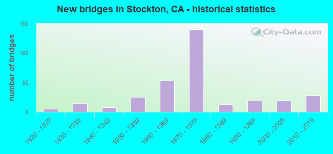
- New bridges - historical statistics
- 11910-1919
- 51920-1929
- 151930-1939
- 81940-1949
- 251950-1959
- 531960-1969
- 1401970-1979
- 131980-1989
- 201990-1999
- 192000-2009
- 282010-2019

- Reconstructed bridges - Historical Statistics
- 21940-1949
- 01950-1959
- 61960-1969
- 41970-1979
- 31980-1989
- 81990-1999
- 92000-2009
- 152010-2019


- Bridge Condition - Deck
- 40.6%Good
- 9.9%Satisfactory
- 36.6%Fair
- 12.9%Poor

- Bridge Condition - Superstructure
- 58.1%Good
- 5.9%Satisfactory
- 26.1%Fair
- 9.9%Poor

- Bridge Condition - Substructure
- 78.8%Good
- 4.4%Satisfactory
- 16.7%Fair

- Bridge Condition - Channel
- 6.9%Excellent
- 22.8%Very good
- 42.1%Good
- 20.7%Satisfactory
- 5.5%Fair
- 1.4%Poor
- 0.7%Serious

- Bridge Condition - Culverts
- 4.0%Very good
- 44.0%Good
- 48.0%Satisfactory
- 4.0%Poor
Find on map >> Show street view
Structure Number: 29 0238S, Location: 10-SJ-004-R16.20-STKN (Lat: 37.948358, Lng: -121.297922), Route carried "on" structure: Ramp State highway 4, Year Built: 1972, Status: Open, Structure Length: 4.02m (13.19ft), Average Daily Traffic: 4,700 (year 2000), Truck Traffic: 10%, Average Future Daily Traffic: 7,615 (year 2041), Design Load: HS 20+Mod, Features Intersected: MORMON SLOUGH
Minimum Vertical Clearance: 30+ m (98+ ft), Kilometerpoint: 16.200, Lanes on structure: 2, Base Highway Network: Yes (, Subroute: 1), Owner: State Highway Agency, Approaching Roadway Width: 8.5m (27.9ft), Material/Design: Concrete continuous, Design/Construction: Slab, Number Of Spans In Main Unit: 5, Length of Maximum Span: 8.5m (27.9ft), Curb or Sidewalk Widths: Left: 0.6m (2.0ft), Right: 0.6m (2.0ft), Curb-To-Curb Width: 8.5m (27.9ft), Out-to-Out Width: 10.3m (33.8ft)
Condition: Deck: Good, Superstructure: Good, Substructure: Fair, Channel: Good, Operating Rating: 57.0 metric tons, Method Used To Determine Operating Rating: Load Factor (LF), Inventory Rating: 34.3 metric tons, Method Used To Determine Inventory Rating: Load Factor (LF), Structural Evaluation: Somewhat better than minimum adequacy, Deck Geometry: High priority of corrective action, Waterway Adequacy: Equal to present desirable criteria, Approach Roadway Alignment: Equal to present desirable criteria, Designated Inspection Frequency: Every 24 months, Underwater Inspection Frequency: Every 60 months, Inspection Date: June 2021, Underwater Inspection Date: March 2021, Deck Structure Type: Concrete Cast-file-Place
Find on map >> Show street view
Structure Number: 29 0239F, Location: 10-SJ-004-R16.48-STKN (Lat: 37.949803, Lng: -121.293342), Route carried "on" structure: Ramp State highway 4, Year Built: 1972, Status: Open, Structure Length: 4.51m (14.80ft), Average Daily Traffic: 15,500 (year 2009), Truck Traffic: 14%, Average Future Daily Traffic: 16,630 (year 2041), Design Load: HS 20+Mod, Features Intersected: MADISON STREET
Minimum Vertical Clearance: 30+ m (98+ ft), Kilometerpoint: 16.480, Lanes on structure: 4, Lanes under structure: 4, Base Highway Network: Yes (, Subroute: 1), Owner: State Highway Agency, Approaching Roadway Width: 22.9m (75.1ft), Skew: 20 degrees, Material/Design: Prestressed concrete, Design/Construction: Box Beam or Girders - Multiple, Number Of Spans In Main Unit: 1, Length of Maximum Span: 44.2m (145.0ft), Curb-To-Curb Width: 22.3m (73.2ft), Out-to-Out Width: 23.1m (75.8ft)
Condition: Deck: Fair, Superstructure: Good, Substructure: Good, Operating Rating: 54.1 metric tons, Method Used To Determine Operating Rating: Load and Resistance Factor Rating (LRFR) rating reported by rating factor(RF) method using HL-93 loadings, Inventory Rating: 36.0 metric tons, Method Used To Determine Inventory Rating: Load and Resistance Factor Rating (LRFR) rating reported by rating factor(RF) method using HL-93 loadings, Structural Evaluation: Better than present minimum criteria, Deck Geometry: Superior to present desirable criteria, Underclear: Equal to present desirable criteria, Approach Roadway Alignment: Equal to present desirable criteria, Designated Inspection Frequency: Every 24 months, Inspection Date: June 2021, Deck Structure Type: Concrete Cast-file-Place
Find on map >> Show street view
Structure Number: 29 0239H, Location: 10-SJ-005-26.11-STKN (Lat: 37.949044, Lng: -121.293142), Route carried "on" structure: Ramp Interstate 5, Year Built: 1972, Status: Open, Structure Length: 4.51m (14.80ft), Average Daily Traffic: 31,200 (year 2009), Truck Traffic: 2%, Average Future Daily Traffic: 39,678 (year 2041), Design Load: HS 20+Mod, Features Intersected: MADISON STREET
Minimum Vertical Clearance: 30+ m (98+ ft), Kilometerpoint: 26.110, Lanes on structure: 5, Lanes under structure: 2, Base Highway Network: Yes (, Subroute: 1), Owner: State Highway Agency, Approaching Roadway Width: 22.2m (72.8ft), Material/Design: Prestressed concrete, Design/Construction: Box Beam or Girders - Multiple, Number Of Spans In Main Unit: 1, Length of Maximum Span: 44.1m (144.7ft), Curb-To-Curb Width: 22.2m (72.8ft), Out-to-Out Width: 24.8m (81.4ft)
Condition: Deck: Satisfactory, Superstructure: Good, Substructure: Good, Operating Rating: 51.8 metric tons, Method Used To Determine Operating Rating: Load and Resistance Factor Rating (LRFR) rating reported by rating factor(RF) method using HL-93 loadings, Inventory Rating: 36.0 metric tons, Method Used To Determine Inventory Rating: Load and Resistance Factor Rating (LRFR) rating reported by rating factor(RF) method using HL-93 loadings, Structural Evaluation: Better than present minimum criteria, Deck Geometry: Equal to present desirable criteria, Underclear: Equal to present desirable criteria, Approach Roadway Alignment: Equal to present desirable criteria, Designated Inspection Frequency: Every 24 months, Inspection Date: August 2021, Deck Structure Type: Concrete Cast-file-Place
Find on map >> Show street view
Structure Number: 29 0239L, Location: 10-SJ-004-R16.47-STKN (Lat: 37.949606, Lng: -121.293328), Route carried "on" structure: State highway 4, Year Built: 1972, Status: Open, Structure Length: 4.51m (14.80ft), Average Daily Traffic: 15,500 (year 2009), Truck Traffic: 11%, Average Future Daily Traffic: 38,636 (year 2041), Design Load: HS 20+Mod, Features Intersected: MADISON STREET
Minimum Vertical Clearance: 30+ m (98+ ft), Kilometerpoint: 16.470, Lanes on structure: 2, Lanes under structure: 2, Base Highway Network: Yes (, Subroute: 1), Owner: State Highway Agency, Approaching Roadway Width: 15.8m (51.8ft), Material/Design: Prestressed concrete, Design/Construction: Box Beam or Girders - Multiple, Number Of Spans In Main Unit: 1, Length of Maximum Span: 44.2m (145.0ft), Curb-To-Curb Width: 15.5m (50.9ft), Out-to-Out Width: 16.3m (53.5ft)
Condition: Deck: Satisfactory, Superstructure: Good, Substructure: Fair, Operating Rating: 42.4 metric tons, Method Used To Determine Operating Rating: Load and Resistance Factor Rating (LRFR) rating reported by rating factor(RF) method using HL-93 loadings, Inventory Rating: 27.2 metric tons, Method Used To Determine Inventory Rating: Load and Resistance Factor Rating (LRFR) rating reported by rating factor(RF) method using HL-93 loadings, Structural Evaluation: Somewhat better than minimum adequacy, Deck Geometry: Superior to present desirable criteria, Underclear: Equal to present desirable criteria, Approach Roadway Alignment: Equal to present desirable criteria, Designated Inspection Frequency: Every 24 months, Inspection Date: June 2021, Deck Structure Type: Concrete Cast-file-Place
Find on map >> Show street view
Structure Number: 29 0239R, Location: 10-SJ-004-R16.47-STKN (Lat: 37.949358, Lng: -121.293228), Route carried "on" structure: State highway 4, Year Built: 1972, Status: Open, Structure Length: 4.51m (14.80ft), Average Daily Traffic: 15,500 (year 2009), Truck Traffic: 11%, Average Future Daily Traffic: 38,636 (year 2041), Design Load: HS 20+Mod, Features Intersected: MADISON STREET
Minimum Vertical Clearance: 30+ m (98+ ft), Kilometerpoint: 16.470, Lanes on structure: 2, Lanes under structure: 4, Base Highway Network: Yes (, Subroute: 1), Owner: State Highway Agency, Approaching Roadway Width: 15.8m (51.8ft), Material/Design: Prestressed concrete, Design/Construction: Box Beam or Girders - Multiple, Number Of Spans In Main Unit: 1, Length of Maximum Span: 44.2m (145.0ft), Curb-To-Curb Width: 15.5m (50.9ft), Out-to-Out Width: 16.2m (53.1ft)
Condition: Deck: Fair, Superstructure: Good, Substructure: Good, Operating Rating: 42.4 metric tons, Method Used To Determine Operating Rating: Load and Resistance Factor Rating (LRFR) rating reported by rating factor(RF) method using HL-93 loadings, Inventory Rating: 27.2 metric tons, Method Used To Determine Inventory Rating: Load and Resistance Factor Rating (LRFR) rating reported by rating factor(RF) method using HL-93 loadings, Structural Evaluation: Equal to present minimum criteria, Deck Geometry: Superior to present desirable criteria, Underclear: Equal to present desirable criteria, Approach Roadway Alignment: Equal to present desirable criteria, Designated Inspection Frequency: Every 24 months, Inspection Date: June 2021, Deck Structure Type: Concrete Cast-file-Place
Find on map >> Show street view
Structure Number: 29 0240L, Location: 10-SJ-004-R15.67-STKN (Lat: 37.946228, Lng: -121.307158), Route carried "on" structure: State highway 4, Year Built: 1972, Status: Open, Structure Length: 5.91m (19.39ft), Average Daily Traffic: 13,250 (year 2009), Truck Traffic: 5%, Average Future Daily Traffic: 11,690 (year 2041), Design Load: HS 20+Mod, Features Intersected: SPBR & GARFIELD AVE
Minimum Vertical Clearance: 30+ m (98+ ft), Kilometerpoint: 15.670, Lanes on structure: 4, Lanes under structure: 2, Base Highway Network: Yes (, Subroute: 1), Owner: State Highway Agency, Approaching Roadway Width: 22.9m (75.1ft), Skew: 2 degrees, Material/Design: Concrete continuous, Design/Construction: Box Beam or Girders - Multiple, Number Of Spans In Main Unit: 2, Length of Maximum Span: 35.1m (115.2ft), Curb-To-Curb Width: 22.9m (75.1ft), Out-to-Out Width: 23.6m (77.4ft)
Condition: Deck: Poor, Superstructure: Fair, Substructure: Good, Operating Rating: 85.9 metric tons, Method Used To Determine Operating Rating: Load Factor (LF), Inventory Rating: 51.5 metric tons, Method Used To Determine Inventory Rating: Load Factor (LF), Structural Evaluation: Somewhat better than minimum adequacy, Deck Geometry: Superior to present desirable criteria, Underclear: Somewhat better than minimum adequacy, Approach Roadway Alignment: Equal to present desirable criteria, Designated Inspection Frequency: Every 24 months, Inspection Date: June 2021, Deck Structure Type: Concrete Cast-file-Place
Find on map >> Show street view
Structure Number: 29 0240R, Location: 10-SJ-004-R15.67-STKN (Lat: 37.945844, Lng: -121.307053), Route carried "on" structure: State highway 4, Year Built: 1972, Status: Open, Structure Length: 5.91m (19.39ft), Average Daily Traffic: 13,250 (year 2009), Truck Traffic: 5%, Average Future Daily Traffic: 11,690 (year 2041), Design Load: HS 20+Mod, Features Intersected: SPBR & GARFIELD AVE
Minimum Vertical Clearance: 30+ m (98+ ft), Kilometerpoint: 15.670, Lanes on structure: 4, Lanes under structure: 2, Base Highway Network: Yes (, Subroute: 1), Owner: State Highway Agency, Approaching Roadway Width: 26.2m (86.0ft), Skew: 2 degrees, Material/Design: Concrete continuous, Design/Construction: Box Beam or Girders - Multiple, Number Of Spans In Main Unit: 2, Length of Maximum Span: 35.1m (115.2ft), Curb-To-Curb Width: 26.2m (86.0ft), Out-to-Out Width: 26.8m (87.9ft)
Condition: Deck: Poor, Superstructure: Fair, Substructure: Good, Operating Rating: 99.8 metric tons, Method Used To Determine Operating Rating: Load Factor (LF), Inventory Rating: 60.9 metric tons, Method Used To Determine Inventory Rating: Load Factor (LF), Structural Evaluation: Somewhat better than minimum adequacy, Deck Geometry: Superior to present desirable criteria, Underclear: Somewhat better than minimum adequacy, Approach Roadway Alignment: Equal to present desirable criteria, Designated Inspection Frequency: Every 24 months, Inspection Date: June 2021, Deck Structure Type: Concrete Cast-file-Place
Find on map >> Show street view
Structure Number: 29 0260L, Location: 10-SJ-005-6.41 (Lat: 37.681061, Lng: -121.343381), Route carried "on" structure: Interstate 5, Year Built: 1971, Status: Open, Structure Length: 11.40m (37.40ft), Average Daily Traffic: 11,400 (year 2016), Truck Traffic: 25%, Average Future Daily Traffic: 22,365 (year 2038), Design Load: HS 20+Mod, Features Intersected: CFNR & STATE ROUTE 33
Minimum Vertical Clearance: 30+ m (98+ ft), Kilometerpoint: 6.410, Lanes on structure: 2, Lanes under structure: 3, Base Highway Network: Yes (, Subroute: 1), Owner: State Highway Agency, Approaching Roadway Width: 12.5m (41.0ft), Skew: 4 degrees, Material/Design: Prestressed concrete continuous, Design/Construction: Box Beam or Girders - Multiple, Number Of Spans In Main Unit: 2, Length of Maximum Span: 57.0m (187.0ft), Curb-To-Curb Width: 12.5m (41.0ft), Out-to-Out Width: 13.4m (44.0ft)
Condition: Deck: Fair, Superstructure: Good, Substructure: Fair, Operating Rating: 99.8 metric tons, Method Used To Determine Operating Rating: Load Factor (LF), Inventory Rating: 32.4 metric tons, Method Used To Determine Inventory Rating: Load Factor (LF), Structural Evaluation: Somewhat better than minimum adequacy, Deck Geometry: Better than present minimum criteria, Underclear: Equal to present minimum criteria, Approach Roadway Alignment: Equal to present desirable criteria, Designated Inspection Frequency: Every 24 months, Inspection Date: October 2020, Deck Structure Type: Concrete Cast-file-Place
Find on map >> Show street view
Structure Number: 29 0269, Location: 10-SJ-004-R16.62-STKN (Lat: 37.949703, Lng: -121.290542), Route carried "on" structure: State highway 4, Year Built: 1975, Year Reconstructed: 1988, Status: Open, Structure Length: 133.11m (436.71ft), Average Daily Traffic: 74,000 (year 2009), Truck Traffic: 10%, Average Future Daily Traffic: 114,198 (year 2041), Design Load: HS 20+Mod, Features Intersected: CROSSTOWN FWY VIADUCT
Minimum Vertical Clearance: 30+ m (98+ ft), Kilometerpoint: 16.620, Lanes on structure: 6, Lanes under structure: 23, Base Highway Network: Yes (, Subroute: 1), Owner: State Highway Agency, Approaching Roadway Width: 37.9m (124.3ft), Skew: 10 degrees, Material/Design: Prestressed concrete continuous, Design/Construction: Box Beam or Girders - Multiple, Number Of Spans In Main Unit: 36, Length of Maximum Span: 39.6m (129.9ft), Curb-To-Curb Width: 30.6m (100.4ft), Out-to-Out Width: 33.1m (108.6ft)
Condition: Deck: Satisfactory, Superstructure: Fair, Substructure: Good, Operating Rating: 54.1 metric tons, Method Used To Determine Operating Rating: Assigned rating based on Load Factor Design (LFD) reported in metric tons, Inventory Rating: 32.4 metric tons, Method Used To Determine Inventory Rating: Assigned rating based on Load Factor Design (LFD) reported in metric tons, Structural Evaluation: Somewhat better than minimum adequacy, Deck Geometry: Superior to present desirable criteria, Underclear: Meets minimum limits, Approach Roadway Alignment: Equal to present desirable criteria, Designated Inspection Frequency: Every 24 months, Inspection Date: June 2021, Deck Structure Type: Concrete Cast-file-Place
Find on map >> Show street view
Structure Number: 29 0300L, Location: 10-SJ-004-R17.56-STKN (Lat: 37.952894, Lng: -121.273911), Route carried "on" structure: State highway 4, Year Built: 1988, Status: Open, Structure Length: 4.94m (16.21ft), Average Daily Traffic: 44,500 (year 2009), Truck Traffic: 11%, Average Future Daily Traffic: 68,846 (year 2041), Design Load: HS 20+Mod, Features Intersected: AIRPORT WAY
Minimum Vertical Clearance: 30+ m (98+ ft), Kilometerpoint: 17.560, Lanes on structure: 4, Lanes under structure: 4, Base Highway Network: Yes (, Subroute: 1), Owner: State Highway Agency, Approaching Roadway Width: 17.1m (56.1ft), Material/Design: Prestressed concrete, Design/Construction: Box Beam or Girders - Multiple, Number Of Spans In Main Unit: 1, Length of Maximum Span: 47.9m (157.2ft), Curb-To-Curb Width: 20.4m (66.9ft), Out-to-Out Width: 22.2m (72.8ft)
Condition: Deck: Good, Superstructure: Satisfactory, Substructure: Good, Operating Rating: 54.1 metric tons, Method Used To Determine Operating Rating: Assigned rating based on Load Factor Design (LFD) reported in metric tons, Inventory Rating: 32.4 metric tons, Method Used To Determine Inventory Rating: Assigned rating based on Load Factor Design (LFD) reported in metric tons, Structural Evaluation: Equal to present minimum criteria, Deck Geometry: Equal to present minimum criteria, Underclear: Better than present minimum criteria, Approach Roadway Alignment: Equal to present desirable criteria, Designated Inspection Frequency: Every 24 months, Inspection Date: June 2021, Deck Structure Type: Concrete Cast-file-Place
Find on map >> Show street view
Structure Number: 29 0300R, Location: 10-SJ-004-R17.56-STKN (Lat: 37.952569, Lng: -121.273822), Route carried "on" structure: State highway 4, Year Built: 1988, Status: Open, Structure Length: 4.94m (16.21ft), Average Daily Traffic: 44,500 (year 2009), Truck Traffic: 11%, Average Future Daily Traffic: 68,846 (year 2041), Design Load: HS 20+Mod, Features Intersected: AIRPORT WAY
Minimum Vertical Clearance: 30+ m (98+ ft), Kilometerpoint: 17.560, Lanes on structure: 4, Lanes under structure: 4, Base Highway Network: Yes (, Subroute: 1), Owner: State Highway Agency, Approaching Roadway Width: 17.1m (56.1ft), Skew: 10 degrees, Material/Design: Prestressed concrete, Design/Construction: Box Beam or Girders - Multiple, Number Of Spans In Main Unit: 1, Length of Maximum Span: 47.9m (157.2ft), Curb-To-Curb Width: 15.3m (50.2ft), Out-to-Out Width: 16.6m (54.5ft)
Condition: Deck: Fair, Superstructure: Satisfactory, Substructure: Satisfactory, Operating Rating: 54.1 metric tons, Method Used To Determine Operating Rating: Assigned rating based on Load Factor Design (LFD) reported in metric tons, Inventory Rating: 32.4 metric tons, Method Used To Determine Inventory Rating: Assigned rating based on Load Factor Design (LFD) reported in metric tons, Structural Evaluation: Equal to present minimum criteria, Deck Geometry: High priority of replacement, Underclear: Equal to present minimum criteria, Approach Roadway Alignment: Equal to present desirable criteria, Designated Inspection Frequency: Every 24 months, Inspection Date: June 2021, Deck Structure Type: Concrete Cast-file-Place
Find on map >> Show street view
Structure Number: 29 0303, Location: 10-SJ-004-R18.06-STKN (Lat: 37.955456, Lng: -121.265933), Route carried "on" structure: City street , Year Built: 1992, Status: Open, Structure Length: 8.69m (28.51ft), Average Daily Traffic: 12,000 (year 2009), Truck Traffic: 3%, Average Future Daily Traffic: 16,138 (year 2041), Design Load: HS 20+Mod, Features Intersected: SR 4, Facility Carried by Structure: MAIN STREET
Minimum Vertical Clearance: 30+ m (98+ ft), Kilometerpoint: 0.000, Lanes on structure: 4, Lanes under structure: 6, Owner: State Highway Agency, Approaching Roadway Width: 24.4m (80.1ft), Skew: 4 degrees, Material/Design: Prestressed concrete continuous, Design/Construction: Box Beam or Girders - Multiple, Number Of Spans In Main Unit: 2, Length of Maximum Span: 44.9m (147.3ft), Curb or Sidewalk Widths: Left: 2.4m (7.9ft), Right: 2.4m (7.9ft), Curb-To-Curb Width: 19.5m (64.0ft), Out-to-Out Width: 25.0m (82.0ft)
Condition: Deck: Satisfactory, Superstructure: Fair, Substructure: Good, Operating Rating: 54.1 metric tons, Method Used To Determine Operating Rating: Assigned rating based on Load Factor Design (LFD) reported in metric tons, Inventory Rating: 32.4 metric tons, Method Used To Determine Inventory Rating: Assigned rating based on Load Factor Design (LFD) reported in metric tons, Structural Evaluation: Somewhat better than minimum adequacy, Deck Geometry: Better than present minimum criteria, Underclear: Somewhat better than minimum adequacy, Approach Roadway Alignment: Equal to present desirable criteria, Designated Inspection Frequency: Every 24 months, Inspection Date: June 2021, Deck Structure Type: Concrete Cast-file-Place
Find on map >> Show street view
Structure Number: 29 0304, Location: 10-SJ-004-R18.52-STKN (Lat: 37.958772, Lng: -121.258328), Route carried "on" structure: City street , Year Built: 1992, Status: Open, Structure Length: 6.22m (20.41ft), Average Daily Traffic: 2,200 (year 2009), Truck Traffic: 2%, Average Future Daily Traffic: 3,240 (year 2043), Design Load: HS 20+Mod, Features Intersected: SR 4, Facility Carried by Structure: E ST
Minimum Vertical Clearance: 30+ m (98+ ft), Kilometerpoint: 0.000, Lanes on structure: 2, Lanes under structure: 6, Owner: State Highway Agency, Approaching Roadway Width: 17.1m (56.1ft), Material/Design: Prestressed concrete continuous, Design/Construction: Box Beam or Girders - Multiple, Number Of Spans In Main Unit: 2, Length of Maximum Span: 31.4m (103.0ft), Curb or Sidewalk Widths: Left: 2.4m (7.9ft), Right: 2.4m (7.9ft), Curb-To-Curb Width: 12.2m (40.0ft), Out-to-Out Width: 17.7m (58.1ft)
Condition: Deck: Satisfactory, Superstructure: Good, Substructure: Good, Operating Rating: 54.1 metric tons, Method Used To Determine Operating Rating: Assigned rating based on Load Factor Design (LFD) reported in metric tons, Inventory Rating: 32.4 metric tons, Method Used To Determine Inventory Rating: Assigned rating based on Load Factor Design (LFD) reported in metric tons, Structural Evaluation: Better than present minimum criteria, Deck Geometry: Equal to present minimum criteria, Underclear: Equal to present minimum criteria, Approach Roadway Alignment: Equal to present desirable criteria, Designated Inspection Frequency: Every 24 months, Inspection Date: June 2021, Deck Structure Type: Concrete Cast-file-Place
Find on map >> Show street view
Structure Number: 29 0305, Location: 10-SJ-004-R18.77-STKN (Lat: 37.959878, Lng: -121.253894), Route carried "on" structure: City street , Year Built: 1992, Status: Open, Structure Length: 5.52m (18.11ft), Average Daily Traffic: 16,500 (year 2009), Truck Traffic: 3%, Average Future Daily Traffic: 23,128 (year 2043), Design Load: HS 20+Mod, Features Intersected: SR 4, Facility Carried by Structure: FILBERT ST
Minimum Vertical Clearance: 30+ m (98+ ft), Kilometerpoint: 0.000, Lanes on structure: 6, Lanes under structure: 6, Owner: State Highway Agency, Approaching Roadway Width: 28.0m (91.9ft), Material/Design: Prestressed concrete continuous, Design/Construction: Box Beam or Girders - Multiple, Number Of Spans In Main Unit: 2, Length of Maximum Span: 28.7m (94.2ft), Curb or Sidewalk Widths: Left: 2.4m (7.9ft), Right: 2.4m (7.9ft), Curb-To-Curb Width: 23.2m (76.1ft), Out-to-Out Width: 28.7m (94.2ft)
Condition: Deck: Fair, Superstructure: Fair, Substructure: Fair, Operating Rating: 54.1 metric tons, Method Used To Determine Operating Rating: Assigned rating based on Load Factor Design (LFD) reported in metric tons, Inventory Rating: 32.4 metric tons, Method Used To Determine Inventory Rating: Assigned rating based on Load Factor Design (LFD) reported in metric tons, Structural Evaluation: Somewhat better than minimum adequacy, Deck Geometry: Meets minimum limits, Underclear: Equal to present minimum criteria, Approach Roadway Alignment: Equal to present desirable criteria, Designated Inspection Frequency: Every 24 months, Inspection Date: June 2021, Deck Structure Type: Concrete Cast-file-Place
Find on map >> Show street view
Structure Number: 29 0306L, Location: 10-SJ-004-R17.71-STKN (Lat: 37.953347, Lng: -121.271147), Route carried "on" structure: State highway 4, Year Built: 1992, Status: Open, Structure Length: 4.94m (16.21ft), Average Daily Traffic: 45,500 (year 2009), Truck Traffic: 11%, Average Future Daily Traffic: 68,846 (year 2041), Design Load: HS 20+Mod, Features Intersected: WILSON WAY
Minimum Vertical Clearance: 30+ m (98+ ft), Kilometerpoint: 17.710, Lanes on structure: 3, Lanes under structure: 5, Base Highway Network: Yes (, Subroute: 1), Owner: State Highway Agency, Approaching Roadway Width: 17.1m (56.1ft), Material/Design: Prestressed concrete, Design/Construction: Box Beam or Girders - Multiple, Number Of Spans In Main Unit: 1, Length of Maximum Span: 48.0m (157.5ft), Curb-To-Curb Width: 16.6m (54.5ft), Out-to-Out Width: 18.4m (60.4ft)
Condition: Deck: Satisfactory, Superstructure: Fair, Substructure: Good, Operating Rating: 54.1 metric tons, Method Used To Determine Operating Rating: Assigned rating based on Load Factor Design (LFD) reported in metric tons, Inventory Rating: 32.4 metric tons, Method Used To Determine Inventory Rating: Assigned rating based on Load Factor Design (LFD) reported in metric tons, Structural Evaluation: Somewhat better than minimum adequacy, Deck Geometry: Equal to present minimum criteria, Underclear: Better than present minimum criteria, Approach Roadway Alignment: Equal to present desirable criteria, Designated Inspection Frequency: Every 24 months, Inspection Date: June 2021, Deck Structure Type: Concrete Cast-file-Place
Find on map >> Show street view
Structure Number: 29 0306R, Location: 10-SJ-004-R17.71-STKN (Lat: 37.953111, Lng: -121.271089), Route carried "on" structure: State highway 4, Year Built: 1992, Status: Open, Structure Length: 4.94m (16.21ft), Average Daily Traffic: 45,500 (year 2009), Truck Traffic: 11%, Average Future Daily Traffic: 68,846 (year 2041), Design Load: HS 20+Mod, Features Intersected: WILSON WAY
Minimum Vertical Clearance: 30+ m (98+ ft), Kilometerpoint: 17.710, Lanes on structure: 3, Lanes under structure: 5, Base Highway Network: Yes (, Subroute: 1), Owner: State Highway Agency, Approaching Roadway Width: 17.1m (56.1ft), Material/Design: Prestressed concrete, Design/Construction: Box Beam or Girders - Multiple, Number Of Spans In Main Unit: 1, Length of Maximum Span: 48.0m (157.5ft), Curb-To-Curb Width: 16.6m (54.5ft), Out-to-Out Width: 18.4m (60.4ft)
Condition: Deck: Fair, Superstructure: Fair, Substructure: Good, Operating Rating: 54.1 metric tons, Method Used To Determine Operating Rating: Assigned rating based on Load Factor Design (LFD) reported in metric tons, Inventory Rating: 32.4 metric tons, Method Used To Determine Inventory Rating: Assigned rating based on Load Factor Design (LFD) reported in metric tons, Structural Evaluation: Somewhat better than minimum adequacy, Deck Geometry: Equal to present minimum criteria, Underclear: Better than present minimum criteria, Approach Roadway Alignment: Equal to present desirable criteria, Designated Inspection Frequency: Every 24 months, Inspection Date: June 2021, Deck Structure Type: Concrete Cast-file-Place
Find on map >> Show street view
Structure Number: 29 0308, Location: 10-SJ-099-18.89 (Lat: 37.964136, Lng: -121.243492), Route carried "on" structure: County highway , Year Built: 1991, Status: Open, Structure Length: 9.55m (31.33ft), Average Daily Traffic: 500 (year 1998), Truck Traffic: 3%, Average Future Daily Traffic: 1,631 (year 2040), Design Load: HS 20+Mod, Features Intersected: STATE ROUTE 99 & RAMPS, Facility Carried by Structure: MYRTLE STREET
Minimum Vertical Clearance: 30+ m (98+ ft), Kilometerpoint: 0.000, Lanes on structure: 2, Lanes under structure: 8, Owner: State Highway Agency, Approaching Roadway Width: 12.2m (40.0ft), Material/Design: Prestressed concrete continuous, Design/Construction: Box Beam or Girders - Multiple, Number Of Spans In Main Unit: 2, Length of Maximum Span: 51.8m (169.9ft), Curb or Sidewalk Widths: Left: 2.7m (8.9ft), Right: 0.0m, Curb-To-Curb Width: 12.2m (40.0ft), Out-to-Out Width: 15.9m (52.2ft)
Condition: Deck: Good, Superstructure: Good, Substructure: Good, Operating Rating: 54.1 metric tons, Method Used To Determine Operating Rating: Assigned rating based on Load Factor Design (LFD) reported in metric tons, Inventory Rating: 32.4 metric tons, Method Used To Determine Inventory Rating: Assigned rating based on Load Factor Design (LFD) reported in metric tons, Structural Evaluation: Better than present minimum criteria, Deck Geometry: Equal to present desirable criteria, Underclear: Equal to present minimum criteria, Approach Roadway Alignment: Better than present minimum criteria, Designated Inspection Frequency: Every 24 months, Inspection Date: June 2020, Deck Structure Type: Concrete Cast-file-Place
Find on map >> Show street view
Structure Number: 29 0316, Location: 10-SJ-099-14.61-STKN (Lat: 37.904283, Lng: -121.222411), Route carried "on" structure: State highway 99, Year Built: 2006, Status: Open, Structure Length: 14.30m (46.92ft), Average Daily Traffic: 70,500 (year 2009), Truck Traffic: 20%, Average Future Daily Traffic: 91,368 (year 2040), Design Load: HS 20+Mod, Features Intersected: ARCH ROAD
Minimum Vertical Clearance: 30+ m (98+ ft), Kilometerpoint: 14.610, Lanes on structure: 6, Lanes under structure: 6, Base Highway Network: Yes (, Subroute: 1), Owner: State Highway Agency, Approaching Roadway Width: 34.9m (114.5ft), Skew: 30 degrees, Material/Design: Prestressed concrete continuous, Design/Construction: Box Beam or Girders - Multiple, Number Of Spans In Main Unit: 3, Length of Maximum Span: 70.0m (229.7ft), Curb-To-Curb Width: 34.9m (114.5ft), Out-to-Out Width: 36.0m (118.1ft)
Condition: Deck: Good, Superstructure: Good, Substructure: Fair, Operating Rating: 54.1 metric tons, Method Used To Determine Operating Rating: Assigned rating based on Load Factor Design (LFD) reported in metric tons, Inventory Rating: 32.4 metric tons, Method Used To Determine Inventory Rating: Assigned rating based on Load Factor Design (LFD) reported in metric tons, Structural Evaluation: Somewhat better than minimum adequacy, Deck Geometry: Superior to present desirable criteria, Underclear: Meets minimum limits, Approach Roadway Alignment: Equal to present desirable criteria, Designated Inspection Frequency: Every 24 months, Inspection Date: June 2020, Deck Structure Type: Concrete Cast-file-Place
Find on map >> Show street view
Structure Number: 29 032, Location: 10-SJ-099-2.34-RIP (Lat: 37.752364, Lng: -121.141967), Route carried "on" structure: Business County highway W813, Year Built: 2001, Status: Open, Structure Length: 9.32m (30.58ft), Average Daily Traffic: 20,000 (year 2009), Truck Traffic: 30%, Average Future Daily Traffic: 32,821 (year 2042), Design Load: HS 20+Mod, Features Intersected: STATE ROUTE 99, Facility Carried by Structure: JACK TONE ROAD
Minimum Vertical Clearance: 30+ m (98+ ft), Kilometerpoint: 0.000, Lanes on structure: 4, Lanes under structure: 7, Base Highway Network: Yes, Owner: State Highway Agency, Approaching Roadway Width: 16.8m (55.1ft), Skew: 33 degrees, Material/Design: Prestressed concrete continuous, Design/Construction: Box Beam or Girders - Single/Spread, Number Of Spans In Main Unit: 2, Length of Maximum Span: 48.7m (159.8ft), Curb or Sidewalk Widths: Left: 0.0m, Right: 3.4m (11.2ft), Curb-To-Curb Width: 16.8m (55.1ft), Out-to-Out Width: 23.5m (77.1ft)
Condition: Deck: Good, Superstructure: Good, Substructure: Satisfactory, Operating Rating: 54.1 metric tons, Method Used To Determine Operating Rating: Assigned rating based on Load Factor Design (LFD) reported in metric tons, Inventory Rating: 32.4 metric tons, Method Used To Determine Inventory Rating: Assigned rating based on Load Factor Design (LFD) reported in metric tons, Structural Evaluation: Equal to present minimum criteria, Deck Geometry: Somewhat better than minimum adequacy, Underclear: High priority of corrective action, Approach Roadway Alignment: Equal to present desirable criteria, Designated Inspection Frequency: Every 24 months, Inspection Date: October 2020, Deck Structure Type: Concrete Cast-file-Place
Find on map >> Show street view
Structure Number: 29 0324, Location: 10-SJ-099-22.92 (Lat: 38.021025, Lng: -121.258692), Route carried "on" structure: City street , Year Built: 2007, Status: Open, Structure Length: 8.76m (28.74ft), Average Daily Traffic: 18,000 (year 1999), Truck Traffic: 5%, Average Future Daily Traffic: 26,845 (year 2042), Design Load: HS 20+Mod, Features Intersected: STATE ROUTE 99, Facility Carried by Structure: HAMMER LANE
Minimum Vertical Clearance: 30+ m (98+ ft), Kilometerpoint: 0.000, Lanes on structure: 8, Lanes under structure: 9, Owner: State Highway Agency, Approaching Roadway Width: 33.0m (108.3ft), Skew: 20 degrees, Material/Design: Prestressed concrete continuous, Design/Construction: Box Beam or Girders - Multiple, Number Of Spans In Main Unit: 2, Length of Maximum Span: 45.5m (149.3ft), Curb or Sidewalk Widths: Left: 0.0m, Right: 1.5m (4.9ft), Curb-To-Curb Width: 33.0m (108.3ft), Out-to-Out Width: 36.5m (119.8ft)
Condition: Deck: Good, Superstructure: Good, Substructure: Good, Operating Rating: 93.3 metric tons, Method Used To Determine Operating Rating: Field evaluation and documented engineering judgment, Inventory Rating: 56.1 metric tons, Method Used To Determine Inventory Rating: Field evaluation and documented engineering judgment, Structural Evaluation: Better than present minimum criteria, Deck Geometry: Somewhat better than minimum adequacy, Underclear: Equal to present minimum criteria, Approach Roadway Alignment: Equal to present desirable criteria, Designated Inspection Frequency: Every 24 months, Inspection Date: June 2020, Deck Structure Type: Concrete Cast-file-Place, Wearing Surface/Protective System: Wearing Surface: Integral Concrete
Find on map >> Show street view
Structure Number: 29 0325, Location: 10-SJ-099-16.68-STKN (Lat: 37.933822, Lng: -121.234450), Route carried "on" structure: City street , Year Built: 2016, Status: Open, Structure Length: 9.37m (30.74ft), Average Daily Traffic: 9,400 (year 2015), Truck Traffic: 2%, Average Future Daily Traffic: 20,471 (year 2042), Design Load: HL 93, Features Intersected: SR 99, Facility Carried by Structure: MARIPOSA ROAD
Minimum Vertical Clearance: 30+ m (98+ ft), Kilometerpoint: 0.000, Lanes on structure: 6, Lanes under structure: 8, Base Highway Network: Yes, Owner: State Highway Agency, Approaching Roadway Width: 28.0m (91.9ft), Skew: 3 degrees, Material/Design: Prestressed concrete continuous, Design/Construction: Box Beam or Girders - Multiple, Number Of Spans In Main Unit: 2, Length of Maximum Span: 47.5m (155.8ft), Curb or Sidewalk Widths: Left: 2.0m (6.6ft), Right: 2.0m (6.6ft), Curb-To-Curb Width: 28.0m (91.9ft), Out-to-Out Width: 32.0m (105.0ft)
Condition: Deck: Good, Superstructure: Good, Substructure: Good, Operating Rating: 42.1 metric tons, Method Used To Determine Operating Rating: Assigned ratings based on Load and Resistance Factor Design (LRFD) reported by rating factor (RF) using HL93 loadings, Inventory Rating: 32.4 metric tons, Method Used To Determine Inventory Rating: Assigned ratings based on Load and Resistance Factor Design (LRFD) reported by rating factor (RF) using HL93 loadings, Structural Evaluation: Better than present minimum criteria, Deck Geometry: Superior to present desirable criteria, Underclear: Equal to present minimum criteria, Approach Roadway Alignment: Equal to present desirable criteria, Designated Inspection Frequency: Every 24 months, Inspection Date: June 2020, Deck Structure Type: Concrete Cast-file-Place
Find on map >> Show street view
Structure Number: 29 0327, Location: 10-SJ-099-18.15-STKN (Lat: 37.954222, Lng: -121.239492), Route carried "on" structure: City street , Year Built: 2016, Status: Open, Structure Length: 6.10m (20.01ft), Average Daily Traffic: 20,000 (year 2016), Truck Traffic: 5%, Average Future Daily Traffic: 24,566 (year 2040), Design Load: HL 93, Features Intersected: STATE ROUTE 99, Facility Carried by Structure: MAIN STREET
Minimum Vertical Clearance: 30+ m (98+ ft), Kilometerpoint: 0.000, Lanes on structure: 4, Lanes under structure: 8, Base Highway Network: Yes, Owner: State Highway Agency, Approaching Roadway Width: 19.5m (64.0ft), Skew: 2 degrees, Material/Design: Prestressed concrete continuous, Design/Construction: Box Beam or Girders - Multiple, Number Of Spans In Main Unit: 2, Length of Maximum Span: 30.5m (100.1ft), Curb or Sidewalk Widths: Left: 3.0m (9.8ft), Right: 3.0m (9.8ft), Curb-To-Curb Width: 19.5m (64.0ft), Out-to-Out Width: 26.2m (86.0ft)
Condition: Deck: Good, Superstructure: Good, Substructure: Good, Operating Rating: 42.1 metric tons, Method Used To Determine Operating Rating: Assigned ratings based on Load and Resistance Factor Design (LRFD) reported by rating factor (RF) using HL93 loadings, Inventory Rating: 32.4 metric tons, Method Used To Determine Inventory Rating: Assigned ratings based on Load and Resistance Factor Design (LRFD) reported by rating factor (RF) using HL93 loadings, Structural Evaluation: Better than present minimum criteria, Deck Geometry: Better than present minimum criteria, Underclear: Somewhat better than minimum adequacy, Approach Roadway Alignment: Equal to present desirable criteria, Designated Inspection Frequency: Every 24 months, Inspection Date: June 2020, Deck Structure Type: Concrete Cast-file-Place
Find on map >> Show street view
Structure Number: 29 0329, Location: 10-SJ-099-18.02-STKN (Lat: 37.952453, Lng: -121.238958), Route carried "on" structure: City street , Year Built: 2016, Status: Open, Structure Length: 8.05m (26.41ft), Average Daily Traffic: 11,700 (year 2015), Truck Traffic: 2%, Average Future Daily Traffic: 20,471 (year 2042), Design Load: HL 93, Features Intersected: HWY 99, Facility Carried by Structure: DR MLK JR BLVD
Minimum Vertical Clearance: 30+ m (98+ ft), Kilometerpoint: 0.000, Lanes on structure: 2, Lanes under structure: 8, Base Highway Network: Yes, Owner: State Highway Agency, Approaching Roadway Width: 15.2m (49.9ft), Skew: 4 degrees, Material/Design: Prestressed concrete continuous, Design/Construction: Box Beam or Girders - Multiple, Number Of Spans In Main Unit: 2, Number Of Approach Spans: 2, Length of Maximum Span: 41.9m (137.5ft), Curb or Sidewalk Widths: Left: 1.7m (5.6ft), Right: 1.7m (5.6ft), Curb-To-Curb Width: 15.2m (49.9ft), Out-to-Out Width: 19.2m (63.0ft)
Condition: Deck: Good, Superstructure: Good, Substructure: Good, Operating Rating: 42.1 metric tons, Method Used To Determine Operating Rating: Assigned ratings based on Load and Resistance Factor Design (LRFD) reported by rating factor (RF) using HL93 loadings, Inventory Rating: 32.4 metric tons, Method Used To Determine Inventory Rating: Assigned ratings based on Load and Resistance Factor Design (LRFD) reported by rating factor (RF) using HL93 loadings, Structural Evaluation: Better than present minimum criteria, Deck Geometry: Superior to present desirable criteria, Underclear: Equal to present minimum criteria, Approach Roadway Alignment: Equal to present desirable criteria, Designated Inspection Frequency: Every 24 months, Inspection Date: June 2020, Deck Structure Type: Concrete Cast-file-Place
Find on map >> Show street view
Structure Number: 29 0334, Location: 10-SJ-099-16.46-STKN (Lat: 37.930861, Lng: -121.232831), Route carried "on" structure: Ramp State highway 99, Year Built: 2016, Status: Open, Structure Length: 1.55m (5.09ft), Average Daily Traffic: 5,000 (year 2016), Truck Traffic: 13%, Average Future Daily Traffic: 10,202 (year 2042), Design Load: HL 93, Features Intersected: DUCK CREEK SOUTH BRANCH
Minimum Vertical Clearance: 30+ m (98+ ft), Kilometerpoint: 16.460, Lanes on structure: 1, Base Highway Network: Yes (, Subroute: 1), Owner: State Highway Agency, Approaching Roadway Width: 10.1m (33.1ft), Skew: 5 degrees, Material/Design: Prestressed concrete, Design/Construction: Slab, Number Of Spans In Main Unit: 1, Length of Maximum Span: 15.5m (50.9ft), Curb-To-Curb Width: 10.1m (33.1ft), Out-to-Out Width: 10.9m (35.8ft)
Condition: Deck: Good, Superstructure: Good, Substructure: Good, Channel: Excellent, Operating Rating: 42.1 metric tons, Method Used To Determine Operating Rating: Assigned ratings based on Load and Resistance Factor Design (LRFD) reported by rating factor (RF) using HL93 loadings, Inventory Rating: 32.4 metric tons, Method Used To Determine Inventory Rating: Assigned ratings based on Load and Resistance Factor Design (LRFD) reported by rating factor (RF) using HL93 loadings, Structural Evaluation: Better than present minimum criteria, Deck Geometry: Superior to present desirable criteria, Waterway Adequacy: Superior to present desirable criteria, Approach Roadway Alignment: Equal to present desirable criteria, Designated Inspection Frequency: Every 24 months, Inspection Date: June 2020, Deck Structure Type: Concrete Cast-file-Place
Find on map >> Show street view
Structure Number: 29 0335, Location: 10-SJ-099-16.48-STKN (Lat: 37.931067, Lng: -121.232867), Route carried "on" structure: Ramp State highway 99, Year Built: 2016, Status: Open, Structure Length: 3.32m (10.89ft), Average Daily Traffic: 5,000 (year 2016), Truck Traffic: 13%, Average Future Daily Traffic: 10,202 (year 2042), Design Load: HL 93, Features Intersected: DUCK CREEK
Minimum Vertical Clearance: 30+ m (98+ ft), Kilometerpoint: 16.480, Lanes on structure: 1, Base Highway Network: Yes (, Subroute: 1), Owner: State Highway Agency, Approaching Roadway Width: 14.7m (48.2ft), Skew: 4 degrees, Material/Design: Concrete continuous, Design/Construction: Slab, Number Of Spans In Main Unit: 3, Length of Maximum Span: 12.8m (42.0ft), Curb-To-Curb Width: 14.7m (48.2ft), Out-to-Out Width: 15.5m (50.9ft)
Condition: Deck: Good, Superstructure: Good, Substructure: Good, Channel: Excellent, Operating Rating: 42.1 metric tons, Method Used To Determine Operating Rating: Assigned ratings based on Load and Resistance Factor Design (LRFD) reported by rating factor (RF) using HL93 loadings, Inventory Rating: 32.4 metric tons, Method Used To Determine Inventory Rating: Assigned ratings based on Load and Resistance Factor Design (LRFD) reported by rating factor (RF) using HL93 loadings, Structural Evaluation: Better than present minimum criteria, Deck Geometry: Superior to present desirable criteria, Waterway Adequacy: Superior to present desirable criteria, Approach Roadway Alignment: Equal to present desirable criteria, Designated Inspection Frequency: Every 24 months, Inspection Date: June 2020, Deck Structure Type: Concrete Cast-file-Place
Find on map >> Show street view
Structure Number: 29 035, Location: 10-SJ-004-R15.70-STKN (Lat: 37.938800, Lng: -121.320064), Route carried "on" structure: State highway 4, Year Built: 2017, Status: Open, Structure Length: 87.49m (287.04ft), Average Daily Traffic: 15,800 (year 2009), Truck Traffic: 11%, Average Future Daily Traffic: 24,457 (year 2043), Design Load: HL 93, Features Intersected: STATE ROUTE 4
Minimum Vertical Clearance: 30+ m (98+ ft), Kilometerpoint: 15.700, Lanes on structure: 2, Lanes under structure: 8, Base Highway Network: Yes (, Subroute: 1), Owner: State Highway Agency, Approaching Roadway Width: 11.0m (36.1ft), Skew: 30 degrees, Material/Design: Prestressed concrete continuous, Design/Construction: Stringer/Multi-beam, Number Of Spans In Main Unit: 21, Length of Maximum Span: 50.3m (165.0ft), Curb-To-Curb Width: 11.0m (36.1ft), Out-to-Out Width: 11.9m (39.0ft)
Condition: Deck: Satisfactory, Superstructure: Good, Substructure: Good, Operating Rating: 42.1 metric tons, Method Used To Determine Operating Rating: Assigned ratings based on Load and Resistance Factor Design (LRFD) reported by rating factor (RF) using HL93 loadings, Inventory Rating: 32.4 metric tons, Method Used To Determine Inventory Rating: Assigned ratings based on Load and Resistance Factor Design (LRFD) reported by rating factor (RF) using HL93 loadings, Structural Evaluation: Better than present minimum criteria, Deck Geometry: Meets minimum limits, Underclear: Superior to present desirable criteria, Approach Roadway Alignment: Equal to present desirable criteria, Designated Inspection Frequency: Every 24 months, Inspection Date: August 2021, Deck Structure Type: Concrete Cast-file-Place, Wearing Surface/Protective System: Wearing Surface: Integral Concrete
Find on map >> Show street view
Structure Number: 29C0051, Location: S/E OF S.H. 26 (Lat: 38.049289, Lng: -121.014128), Route carried "on" structure: County highway , Year Built: 1966, Status: Open, Structure Length: 6.80m (22.31ft), Average Daily Traffic: 2,430 (year 2013), Truck Traffic: 25%, Average Future Daily Traffic: 1,363 (year 2041), Design Load: HS 20, Features Intersected: MORMON SLOUGH, Facility Carried by Structure: ESCALON BELLOTA RD
Minimum Vertical Clearance: 30+ m (98+ ft), Kilometerpoint: 0.000, Lanes on structure: 2, Owner: County Highway Agency, Approaching Roadway Width: 12.2m (40.0ft), Skew: 1 degrees, Material/Design: Concrete continuous, Design/Construction: Slab, Number Of Spans In Main Unit: 9, Length of Maximum Span: 7.9m (25.9ft), Curb-To-Curb Width: 12.2m (40.0ft), Out-to-Out Width: 12.4m (40.7ft)
Condition: Deck: Poor, Superstructure: Poor, Substructure: Fair, Channel: Serious, Operating Rating: 52.5 metric tons, Method Used To Determine Operating Rating: Load Factor (LF), Inventory Rating: 31.4 metric tons, Method Used To Determine Inventory Rating: Load Factor (LF), Structural Evaluation: Meets minimum limits, Deck Geometry: Equal to present minimum criteria, Waterway Adequacy: Superior to present desirable criteria, Approach Roadway Alignment: Equal to present desirable criteria, Length Of Structure Improvement: 6.80m (22.31ft), Designated Inspection Frequency: Every 24 months, Inspection Date: Febuary 2021, Bridge Improvement Cost: $843,000, Roadway Improvement Cost: $168,000, Total Project Cost: $1,416,000 ( Estimate for 2017), Deck Structure Type: Concrete Cast-file-Place, Wearing Surface/Protective System: Wearing Surface: Bituminous
Find on map >> Show street view
Structure Number: 29C0052, Location: S DAVIS RD IN TX (Lat: 38.028222, Lng: -121.331492), Route carried "on" structure: County highway , Year Built: 1931, Year Reconstructed: 1970, Status: Open, Structure Length: 1.65m (5.41ft), Average Daily Traffic: 26,616 (year 2013), Truck Traffic: 2%, Average Future Daily Traffic: 25,607 (year 2042), Features Intersected: MOSHER SLOUGH, Facility Carried by Structure: THORNTON ROAD
Minimum Vertical Clearance: 30+ m (98+ ft), Kilometerpoint: 0.000, Lanes on structure: 5, Base Highway Network: Yes, Owner: County Highway Agency, Approaching Roadway Width: 28.0m (91.9ft), Skew: 23 degrees, Material/Design: Concrete continuous, Design/Construction: Slab, Number Of Spans In Main Unit: 3, Length of Maximum Span: 5.3m (17.4ft), Curb or Sidewalk Widths: Left: 1.9m (6.2ft), Right: 2.9m (9.5ft), Curb-To-Curb Width: 25.6m (84.0ft), Out-to-Out Width: 32.5m (106.6ft)
Condition: Deck: Good, Superstructure: Good, Substructure: Good, Channel: Good, Operating Rating: 26.9 metric tons, Method Used To Determine Operating Rating: Field evaluation and documented engineering judgment, Inventory Rating: 16.2 metric tons, Method Used To Determine Inventory Rating: Field evaluation and documented engineering judgment, Structural Evaluation: Meets minimum limits, Deck Geometry: Superior to present desirable criteria, Waterway Adequacy: Superior to present desirable criteria, Approach Roadway Alignment: Better than present minimum criteria, Designated Inspection Frequency: Every 24 months, Inspection Date: January 2022, Deck Structure Type: Concrete Cast-file-Place, Wearing Surface/Protective System: Wearing Surface: Bituminous
Find on map >> Show street view
Structure Number: 29C0058L, Location: 0.25 MI N FULTON ST (Lat: 37.983725, Lng: -121.309611), Route carried "on" structure: City street , Year Built: 1921, Year Reconstructed: 1951, Status: Open, Structure Length: 7.71m (25.30ft), Average Daily Traffic: 18,350 (year 2010), Truck Traffic: 5%, Average Future Daily Traffic: 23,863 (year 2042), Features Intersected: CALAVERAS RIVER, Facility Carried by Structure: PACIFIC AVE
Minimum Vertical Clearance: 30+ m (98+ ft), Kilometerpoint: 0.000, Lanes on structure: 2, Owner: City or Municipal Highway Agency, Approaching Roadway Width: 7.3m (24.0ft), Skew: 1 degrees, Material/Design: Concrete, Design/Construction: Tee Beam, Number Of Spans In Main Unit: 6, Length of Maximum Span: 12.8m (42.0ft), Curb or Sidewalk Widths: Left: 2.8m (9.2ft), Right: 1.0m (3.3ft), Curb-To-Curb Width: 7.3m (24.0ft), Out-to-Out Width: 11.4m (37.4ft)
Condition: Deck: Good, Superstructure: Good, Substructure: Good, Channel: Poor, Operating Rating: 23.3 metric tons, Method Used To Determine Operating Rating: Load and Resistance Factor Rating (LRFR) rating reported by rating factor(RF) method using HL-93 loadings, Inventory Rating: 18.1 metric tons, Method Used To Determine Inventory Rating: Load and Resistance Factor Rating (LRFR) rating reported by rating factor(RF) method using HL-93 loadings, Structural Evaluation: Meets minimum limits, Deck Geometry: High priority of replacement, Waterway Adequacy: Equal to present desirable criteria, Approach Roadway Alignment: Equal to present minimum criteria, Designated Inspection Frequency: Every 24 months, Inspection Date: January 2022, Deck Structure Type: Concrete Cast-file-Place, Wearing Surface/Protective System: Wearing Surface: Bituminous
Find on map >> Show street view
Structure Number: 29C0058R, Location: 0.25 MI N FULTON ST (Lat: 37.983856, Lng: -121.309436), Route carried "on" structure: City street , Year Built: 1952, Status: Open, Structure Length: 7.80m (25.59ft), Average Daily Traffic: 18,350 (year 2010), Truck Traffic: 5%, Average Future Daily Traffic: 23,863 (year 2042), Design Load: H 20, Features Intersected: CALAVERAS RIVER, Facility Carried by Structure: PACIFIC AVE
Minimum Vertical Clearance: 30+ m (98+ ft), Kilometerpoint: 0.000, Lanes on structure: 2, Owner: City or Municipal Highway Agency, Approaching Roadway Width: 7.9m (25.9ft), Skew: 1 degrees, Material/Design: Concrete continuous, Design/Construction: Slab, Number Of Spans In Main Unit: 12, Length of Maximum Span: 6.4m (21.0ft), Curb or Sidewalk Widths: Left: 0.7m (2.3ft), Right: 2.0m (6.6ft), Curb-To-Curb Width: 7.9m (25.9ft), Out-to-Out Width: 10.0m (32.8ft)
Condition: Deck: Good, Superstructure: Good, Substructure: Good, Channel: Satisfactory, Operating Rating: 48.0 metric tons, Method Used To Determine Operating Rating: Load Factor (LF), Inventory Rating: 28.8 metric tons, Method Used To Determine Inventory Rating: Load Factor (LF), Structural Evaluation: Better than present minimum criteria, Deck Geometry: High priority of replacement, Waterway Adequacy: Equal to present desirable criteria, Approach Roadway Alignment: Equal to present minimum criteria, Designated Inspection Frequency: Every 24 months, Inspection Date: January 2022, Deck Structure Type: Concrete Cast-file-Place
Find on map >> Show street view
Structure Number: 29C0061, Location: 0.1 MI S JAHANT RD (Lat: 38.204828, Lng: -121.092653), Route carried "on" structure: County highway , Year Built: 1976, Status: Open, Structure Length: 11.06m (36.29ft), Average Daily Traffic: 1,202 (year 2016), Truck Traffic: 15%, Average Future Daily Traffic: 858 (year 2039), Design Load: HS 20, Features Intersected: MOKELUMNE RIVER, Facility Carried by Structure: MACKVILLE ROAD
Minimum Vertical Clearance: 30+ m (98+ ft), Kilometerpoint: 0.000, Lanes on structure: 2, Owner: County Highway Agency, Approaching Roadway Width: 6.1m (20.0ft), Material/Design: Prestressed concrete continuous, Design/Construction: Stringer/Multi-beam, Number Of Spans In Main Unit: 3, Length of Maximum Span: 36.6m (120.1ft), Curb or Sidewalk Widths: Left: 0.0m, Right: 1.5m (4.9ft), Curb-To-Curb Width: 9.8m (32.2ft), Out-to-Out Width: 12.4m (40.7ft)
Condition: Deck: Poor, Superstructure: Good, Substructure: Good, Channel: Satisfactory, Operating Rating: 48.3 metric tons, Method Used To Determine Operating Rating: Load and Resistance Factor Rating (LRFR) rating reported by rating factor(RF) method using HL-93 loadings, Inventory Rating: 30.1 metric tons, Method Used To Determine Inventory Rating: Load and Resistance Factor Rating (LRFR) rating reported by rating factor(RF) method using HL-93 loadings, Structural Evaluation: Better than present minimum criteria, Deck Geometry: Somewhat better than minimum adequacy, Waterway Adequacy: Equal to present desirable criteria, Approach Roadway Alignment: Equal to present desirable criteria, Designated Inspection Frequency: Every 24 months, Underwater Inspection Frequency: Every 60 months, Inspection Date: January 2022, Underwater Inspection Date: July 2021, Deck Structure Type: Concrete Cast-file-Place
Find on map >> Show street view
Structure Number: 29C0066, Location: 0.8 MI S OF 8 MILE ROAD (Lat: 38.042758, Lng: -121.258983), Route carried "on" structure: County highway , Year Built: 1964, Status: Open, Structure Length: 2.53m (8.30ft), Average Daily Traffic: 2,000 (year 2015), Truck Traffic: 18%, Average Future Daily Traffic: 3,000 (year 2038), Design Load: HS 20, Features Intersected: MOSHER SLOUGH, Facility Carried by Structure: 99 FRONTAGE RD W
Minimum Vertical Clearance: 30+ m (98+ ft), Kilometerpoint: 0.000, Lanes on structure: 2, Owner: City or Municipal Highway Agency, Approaching Roadway Width: 9.4m (30.8ft), Material/Design: Concrete continuous, Design/Construction: Slab, Number Of Spans In Main Unit: 3, Length of Maximum Span: 8.2m (26.9ft), Curb or Sidewalk Widths: Left: 0.6m (2.0ft), Right: 0.6m (2.0ft), Curb-To-Curb Width: 7.9m (25.9ft), Out-to-Out Width: 9.8m (32.2ft)
Condition: Deck: Good, Superstructure: Good, Substructure: Good, Channel: Good, Operating Rating: 64.2 metric tons, Method Used To Determine Operating Rating: Load Factor (LF), Inventory Rating: 38.6 metric tons, Method Used To Determine Inventory Rating: Load Factor (LF), Structural Evaluation: Better than present minimum criteria, Deck Geometry: Meets minimum limits, Waterway Adequacy: Equal to present desirable criteria, Approach Roadway Alignment: Equal to present desirable criteria, Designated Inspection Frequency: Every 24 months, Inspection Date: December 2021, Deck Structure Type: Concrete Cast-file-Place, Wearing Surface/Protective System: Wearing Surface: Bituminous
Find on map >> Show street view
Structure Number: 29C0068, Location: 0.4 MI N OF 8 MILE RD (Lat: 38.060247, Lng: -121.259864), Route carried "on" structure: County highway , Year Built: 1964, Status: Open, Structure Length: 5.04m (16.54ft), Average Daily Traffic: 3,737 (year 2015), Truck Traffic: 15%, Average Future Daily Traffic: 8,008 (year 2038), Design Load: HS 20, Features Intersected: BEAR CREEK, Facility Carried by Structure: 99 FRONTAGE RD W
Minimum Vertical Clearance: 30+ m (98+ ft), Kilometerpoint: 0.000, Lanes on structure: 2, Owner: County Highway Agency, Approaching Roadway Width: 9.1m (29.9ft), Skew: 4 degrees, Material/Design: Concrete continuous, Design/Construction: Slab, Number Of Spans In Main Unit: 5, Length of Maximum Span: 11.0m (36.1ft), Curb or Sidewalk Widths: Left: 0.6m (2.0ft), Right: 0.6m (2.0ft), Curb-To-Curb Width: 7.9m (25.9ft), Out-to-Out Width: 9.8m (32.2ft)
Condition: Deck: Good, Superstructure: Good, Substructure: Good, Channel: Satisfactory, Operating Rating: 59.6 metric tons, Method Used To Determine Operating Rating: Load Factor (LF), Inventory Rating: 35.6 metric tons, Method Used To Determine Inventory Rating: Load Factor (LF), Structural Evaluation: Better than present minimum criteria, Deck Geometry: High priority of corrective action, Waterway Adequacy: Better than present minimum criteria, Approach Roadway Alignment: Equal to present minimum criteria, Designated Inspection Frequency: Every 24 months, Inspection Date: September 2021, Deck Structure Type: Concrete Cast-file-Place, Wearing Surface/Protective System: Wearing Surface: Bituminous
Find on map >> Show street view
Structure Number: 29C0074, Location: 1.2 MI N MARIPOSA RD (Lat: 37.921275, Lng: -121.147542), Route carried "on" structure: County highway , Year Built: 1961, Status: Open, Structure Length: 3.47m (11.38ft), Average Daily Traffic: 3,202 (year 2013), Truck Traffic: 2%, Average Future Daily Traffic: 2,254 (year 2043), Design Load: HS 20, Features Intersected: NORTH LITTLE JOHNS CREEK, Facility Carried by Structure: JACK TONE RD
Minimum Vertical Clearance: 30+ m (98+ ft), Kilometerpoint: 0.000, Lanes on structure: 2, Owner: County Highway Agency, Approaching Roadway Width: 9.8m (32.2ft), Skew: 2 degrees, Material/Design: Concrete continuous, Design/Construction: Slab, Number Of Spans In Main Unit: 4, Length of Maximum Span: 9.8m (32.2ft), Curb-To-Curb Width: 9.8m (32.2ft), Out-to-Out Width: 9.9m (32.5ft)
Condition: Deck: Good, Superstructure: Good, Substructure: Good, Channel: Good, Operating Rating: 65.4 metric tons, Method Used To Determine Operating Rating: Load Factor (LF), Inventory Rating: 39.2 metric tons, Method Used To Determine Inventory Rating: Load Factor (LF), Structural Evaluation: Better than present minimum criteria, Deck Geometry: Meets minimum limits, Waterway Adequacy: Equal to present desirable criteria, Approach Roadway Alignment: Equal to present desirable criteria, Designated Inspection Frequency: Every 48 months, Inspection Date: March 2021, Deck Structure Type: Concrete Cast-file-Place, Wearing Surface/Protective System: Wearing Surface: Bituminous
Find on map >> Show street view
Structure Number: 29C008, Location: 1 MI N LIVE OAK RD (Lat: 38.094094, Lng: -121.150756), Route carried "on" structure: County highway , Year Built: 1962, Status: Open, Structure Length: 1.65m (5.41ft), Average Daily Traffic: 2,715 (year 2013), Truck Traffic: 30%, Average Future Daily Traffic: 2,137 (year 2038), Design Load: HS 20, Features Intersected: PADDY CREEK SOUTH, Facility Carried by Structure: JACK TONE RD
Minimum Vertical Clearance: 30+ m (98+ ft), Kilometerpoint: 0.000, Lanes on structure: 2, Owner: County Highway Agency, Approaching Roadway Width: 9.8m (32.2ft), Material/Design: Concrete continuous, Design/Construction: Slab, Number Of Spans In Main Unit: 2, Length of Maximum Span: 7.9m (25.9ft), Curb-To-Curb Width: 9.8m (32.2ft), Out-to-Out Width: 9.9m (32.5ft)
Condition: Deck: Good, Superstructure: Good, Substructure: Good, Channel: Good, Operating Rating: 55.4 metric tons, Method Used To Determine Operating Rating: Load Factor (LF), Inventory Rating: 33.4 metric tons, Method Used To Determine Inventory Rating: Load Factor (LF), Structural Evaluation: Better than present minimum criteria, Deck Geometry: Meets minimum limits, Waterway Adequacy: Better than present minimum criteria, Approach Roadway Alignment: Equal to present desirable criteria, Designated Inspection Frequency: Every 24 months, Inspection Date: September 2021, Deck Structure Type: Concrete Cast-file-Place, Wearing Surface/Protective System: Wearing Surface: Bituminous
Find on map >> Show street view
Structure Number: 29C0086, Location: 0.5 MI N HAMMER LANE (Lat: 38.028053, Lng: -121.294800), Route carried "on" structure: City street , Year Built: 1966, Year Reconstructed: 1972, Status: Open, Structure Length: 1.89m (6.20ft), Average Daily Traffic: 27,300 (year 2007), Truck Traffic: 16%, Average Future Daily Traffic: 23,280 (year 2038), Design Load: H 20, Features Intersected: MOSHER SLOUGH, Facility Carried by Structure: WEST LANE
Minimum Vertical Clearance: 30+ m (98+ ft), Kilometerpoint: 0.000, Lanes on structure: 4, Base Highway Network: Yes, Owner: City or Municipal Highway Agency, Approaching Roadway Width: 25.9m (85.0ft), Skew: 20 degrees, Material/Design: Concrete continuous, Design/Construction: Slab, Number Of Spans In Main Unit: 3, Length of Maximum Span: 7.3m (24.0ft), Curb or Sidewalk Widths: Left: 0.0m, Right: 1.6m (5.2ft), Curb-To-Curb Width: 21.4m (70.2ft), Out-to-Out Width: 29.3m (96.1ft)
Condition: Deck: Satisfactory, Superstructure: Satisfactory, Substructure: Good, Channel: Satisfactory, Operating Rating: 46.7 metric tons, Method Used To Determine Operating Rating: Load Factor (LF), Inventory Rating: 27.9 metric tons, Method Used To Determine Inventory Rating: Load Factor (LF), Structural Evaluation: Equal to present minimum criteria, Deck Geometry: Superior to present desirable criteria, Waterway Adequacy: Better than present minimum criteria, Approach Roadway Alignment: Equal to present desirable criteria, Designated Inspection Frequency: Every 24 months, Inspection Date: December 2021, Deck Structure Type: Concrete Cast-file-Place, Wearing Surface/Protective System: Wearing Surface: Bituminous
Find on map >> Show street view
Structure Number: 29C0087, Location: 1/2 MI N/W OF S.H. 99 (Lat: 37.948439, Lng: -121.241836), Route carried "on" structure: County highway , Year Built: 1966, Year Reconstructed: 2015, Status: Open, Structure Length: 3.66m (12.01ft), Average Daily Traffic: 2,469 (year 2017), Truck Traffic: 2%, Average Future Daily Traffic: 3,600 (year 2039), Design Load: HS 20, Features Intersected: MORMON SLOUGH, Facility Carried by Structure: GOLDEN GATE AVENUE
Minimum Vertical Clearance: 30+ m (98+ ft), Kilometerpoint: 0.000, Lanes on structure: 2, Owner: County Highway Agency, Approaching Roadway Width: 17.6m (57.7ft), Skew: 2 degrees, Material/Design: Concrete continuous, Design/Construction: Slab, Number Of Spans In Main Unit: 4, Length of Maximum Span: 9.1m (29.9ft), Curb or Sidewalk Widths: Left: 1.5m (4.9ft), Right: 1.5m (4.9ft), Curb-To-Curb Width: 17.6m (57.7ft), Out-to-Out Width: 21.2m (69.6ft)
Condition: Deck: Good, Superstructure: Good, Substructure: Good, Channel: Good, Operating Rating: 60.6 metric tons, Method Used To Determine Operating Rating: Load Factor (LF), Inventory Rating: 36.3 metric tons, Method Used To Determine Inventory Rating: Load Factor (LF), Structural Evaluation: Better than present minimum criteria, Deck Geometry: Superior to present desirable criteria, Waterway Adequacy: Equal to present desirable criteria, Approach Roadway Alignment: Equal to present desirable criteria, Designated Inspection Frequency: Every 48 months, Inspection Date: January 2019, Deck Structure Type: Concrete Cast-file-Place
Find on map >> Show street view
Structure Number: 29C0088, Location: 0.3 MI W LINCOLN ST (Lat: 37.951467, Lng: -121.303667), Route carried "on" structure: City street , Year Built: 1969, Status: Open, Structure Length: 4.63m (15.19ft), Average Daily Traffic: 6,100 (year 2005), Truck Traffic: 5%, Average Future Daily Traffic: 7,321 (year 2038), Design Load: HS 20, Features Intersected: MORMON SLOUGH, Facility Carried by Structure: WEBER ST
Minimum Vertical Clearance: 30+ m (98+ ft), Kilometerpoint: 0.000, Lanes on structure: 2, Owner: City or Municipal Highway Agency, Approaching Roadway Width: 28.7m (94.2ft), Skew: 5 degrees, Material/Design: Concrete continuous, Design/Construction: Culvert, Number Of Spans In Main Unit: 6, Length of Maximum Span: 4.0m (13.1ft), Curb or Sidewalk Widths: Left: 2.1m (6.9ft), Right: 2.1m (6.9ft), Curb-To-Curb Width: 28.7m (94.2ft), Out-to-Out Width: 33.5m (109.9ft)
Condition: Channel: Good, Culverts: Satisfactory, Operating Rating: 54.1 metric tons, Method Used To Determine Operating Rating: Field evaluation and documented engineering judgment, Inventory Rating: 32.4 metric tons, Method Used To Determine Inventory Rating: Field evaluation and documented engineering judgment, Structural Evaluation: Equal to present minimum criteria, Deck Geometry: Superior to present desirable criteria, Waterway Adequacy: Equal to present desirable criteria, Approach Roadway Alignment: Equal to present desirable criteria, Designated Inspection Frequency: Every 48 months, Underwater Inspection Frequency: Every 60 months, Inspection Date: January 2021, Underwater Inspection Date: September 2019, Deck Structure Type: Concrete Cast-file-Place, Wearing Surface/Protective System: Wearing Surface: Bituminous
Find on map >> Show street view
Structure Number: 29C009, Location: 17.52 MI N STNLAUS CO LI (Lat: 37.880803, Lng: -121.249019), Route carried "on" structure: County highway , Year Built: 1968, Status: Open, Structure Length: 6.46m (21.19ft), Average Daily Traffic: 12,716 (year 2015), Truck Traffic: 5%, Average Future Daily Traffic: 6,456 (year 2039), Design Load: HS 20, Features Intersected: FRENCH CAMP SLOUGH, Facility Carried by Structure: AIRPORT WAY
Minimum Vertical Clearance: 30+ m (98+ ft), Kilometerpoint: 0.000, Lanes on structure: 4, Owner: City or Municipal Highway Agency, Approaching Roadway Width: 25.9m (85.0ft), Skew: 22 degrees, Material/Design: Concrete continuous, Design/Construction: Slab, Number Of Spans In Main Unit: 7, Length of Maximum Span: 9.1m (29.9ft), Curb-To-Curb Width: 28.7m (94.2ft), Out-to-Out Width: 28.9m (94.8ft)
Condition: Deck: Good, Superstructure: Good, Substructure: Good, Channel: Satisfactory, Operating Rating: 49.6 metric tons, Method Used To Determine Operating Rating: Load Factor (LF), Inventory Rating: 29.8 metric tons, Method Used To Determine Inventory Rating: Load Factor (LF), Structural Evaluation: Better than present minimum criteria, Deck Geometry: Superior to present desirable criteria, Waterway Adequacy: Equal to present desirable criteria, Approach Roadway Alignment: Equal to present minimum criteria, Designated Inspection Frequency: Every 24 months, Inspection Date: Febuary 2021, Deck Structure Type: Concrete Cast-file-Place, Wearing Surface/Protective System: Wearing Surface: Bituminous