Bridge Statistics for Stockton, California (CA)
Condition, Traffic, Stress, Structural Evaluation, Project Costs
- National Bridge Inventory (NBI) Statistics
- 327Number of bridges
- 5,604ft / 1,708mTotal length
- $142,880,000Total costs
- 8,556,472Total average daily traffic
- 1,227,785Total average daily truck traffic
- National Bridge Inventory (NBI) Registered Bridges for Stockton
- No street view available for this location
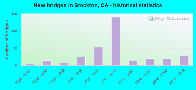
- New bridges - historical statistics
- 11910-1919
- 51920-1929
- 151930-1939
- 81940-1949
- 251950-1959
- 531960-1969
- 1401970-1979
- 131980-1989
- 201990-1999
- 192000-2009
- 282010-2019

- Reconstructed bridges - Historical Statistics
- 21940-1949
- 01950-1959
- 61960-1969
- 41970-1979
- 31980-1989
- 81990-1999
- 92000-2009
- 152010-2019


- Bridge Condition - Deck
- 40.6%Good
- 9.9%Satisfactory
- 36.6%Fair
- 12.9%Poor

- Bridge Condition - Superstructure
- 58.1%Good
- 5.9%Satisfactory
- 26.1%Fair
- 9.9%Poor

- Bridge Condition - Substructure
- 78.8%Good
- 4.4%Satisfactory
- 16.7%Fair

- Bridge Condition - Channel
- 6.9%Excellent
- 22.8%Very good
- 42.1%Good
- 20.7%Satisfactory
- 5.5%Fair
- 1.4%Poor
- 0.7%Serious

- Bridge Condition - Culverts
- 4.0%Very good
- 44.0%Good
- 48.0%Satisfactory
- 4.0%Poor
Find on map >> Show street view
Structure Number: 29 0212L, Location: 10-SJ-005-32.66-STKN (Lat: 38.021153, Lng: -121.358861), Route carried "under" structure: County highway , Year Built: 1970, Structure Length: 0. m, Average Daily Traffic: 26,800 (year 1999), Truck Traffic: 10%, Features Intersected: W HAMMER LANE, Facility Carried by Structure: INTERSTATE 5 SB
Minimum Vertical Clearance: 4.57m (14.99ft), Kilometerpoint: 0.000, Lanes on structure: 3, Lanes under structure: 8, Material/Design: Prestressed concrete, Design/Construction: Box Beam or Girders - Multiple, Length of Maximum Span: 43.3m (142.1ft)
Find on map >> Show street view
Structure Number: 29 0212R, Location: 10-SJ-005-32.66-STKN (Lat: 38.021150, Lng: -121.358453), Route carried "under" structure: City street , Year Built: 1970, Structure Length: 0. m, Average Daily Traffic: 26,800 (year 1999), Truck Traffic: 10%, Features Intersected: W HAMMER LANE, Facility Carried by Structure: INTERSTATE 5 NB
Minimum Vertical Clearance: 4.59m (15.06ft), Kilometerpoint: 0.000, Lanes on structure: 3, Lanes under structure: 8, Material/Design: Prestressed concrete, Design/Construction: Box Beam or Girders - Multiple, Length of Maximum Span: 43.3m (142.1ft)
Find on map >> Show street view
Structure Number: 29 0215, Location: 10-SJ-005-31.11 (Lat: 37.999936, Lng: -121.349172), Route carried "under" structure: County highway , Year Built: 1970, Structure Length: 0. m, Average Daily Traffic: 13,300 (year 1999), Truck Traffic: 10%, Features Intersected: W SWAIN ROAD, Facility Carried by Structure: INTERSTATE 5 NB
Minimum Vertical Clearance: 4.55m (14.93ft), Kilometerpoint: 0.000, Lanes on structure: 8, Lanes under structure: 2, Material/Design: Prestressed concrete, Design/Construction: Box Beam or Girders - Multiple, Length of Maximum Span: 31.1m (102.0ft)
Find on map >> Show street view
Structure Number: 29 0224L, Location: 10-SJ-005-24.64-STKN (Lat: 37.926544, Lng: -121.294511), Route carried "under" structure: City street F123, Year Built: 1971, Structure Length: 0. m, Average Daily Traffic: 650 (year 1998), Truck Traffic: 2%, Features Intersected: EIGHTH STREET, Facility Carried by Structure: INTERSTATE 5
Minimum Vertical Clearance: 4.62m (15.16ft), Kilometerpoint: 0.000, Lanes on structure: 3, Lanes under structure: 4, Material/Design: Prestressed concrete, Design/Construction: Box Beam or Girders - Multiple, Length of Maximum Span: 40.8m (133.9ft)
Find on map >> Show street view
Structure Number: 29 0224R, Location: 10-SJ-005-24.64-STKN (Lat: 37.926583, Lng: -121.294164), Route carried "under" structure: City street F123, Year Built: 1971, Structure Length: 0. m, Average Daily Traffic: 650 (year 1998), Truck Traffic: 5%, Features Intersected: EIGHTH STREET, Facility Carried by Structure: INTERSTATE 5 NB
Minimum Vertical Clearance: 5.20m (17.06ft), Kilometerpoint: 0.000, Lanes on structure: 3, Lanes under structure: 5, Material/Design: Prestressed concrete, Design/Construction: Box Beam or Girders - Multiple, Length of Maximum Span: 41.8m (137.1ft)
Find on map >> Show street view
Structure Number: 29 0225L, Location: 10-SJ-005-25.35-STKN (Lat: 37.936572, Lng: -121.297544), Route carried "under" structure: State highway 4, Year Built: 1971, Structure Length: 0. m, Average Daily Traffic: 12,800 (year 2009), Truck Traffic: 11%, Features Intersected: STATE RTE 4 (CHARTER WY), Facility Carried by Structure: INTERSTATE 5 SB
Minimum Vertical Clearance: 4.75m (15.58ft), Kilometerpoint: 15.910, Lanes on structure: 4, Lanes under structure: 6, Material/Design: Prestressed concrete, Design/Construction: Box Beam or Girders - Multiple, Length of Maximum Span: 45.1m (148.0ft)
Find on map >> Show street view
Structure Number: 29 0225R, Location: 10-SJ-005-25.35-STKN (Lat: 37.936647, Lng: -121.297258), Route carried "under" structure: State highway 4, Year Built: 1971, Structure Length: 0. m, Average Daily Traffic: 27,200 (year 2009), Truck Traffic: 14%, Features Intersected: STATE RTE 4 (CHARTER WY), Facility Carried by Structure: INTERSTATE 5 NB
Minimum Vertical Clearance: 5.28m (17.32ft), Kilometerpoint: 15.910, Lanes on structure: 4, Lanes under structure: 6, Material/Design: Prestressed concrete, Design/Construction: Box Beam or Girders - Multiple, Length of Maximum Span: 45.4m (149.0ft)
Find on map >> Show street view
Structure Number: 29 0231H, Location: 10-SJ-004-R16.00-STKN (Lat: 37.945978, Lng: -121.300136), Route carried "under" structure: City street F119, Year Built: 1972, Structure Length: 0. m, Average Daily Traffic: 1,100 (year 2006), Truck Traffic: 2%, Features Intersected: CHURCH STREET, Facility Carried by Structure: E&W4-S5 CONNECTOR
Minimum Vertical Clearance: 4.85m (15.91ft), Kilometerpoint: 0.000, Lanes on structure: 3, Lanes under structure: 2, Material/Design: Prestressed concrete, Design/Construction: Box Beam or Girders - Multiple, Length of Maximum Span: 32.0m (105.0ft)
Find on map >> Show street view
Structure Number: 29 0231L, Location: 10-SJ-005-25.99-STKN (Lat: 37.945758, Lng: -121.299175), Route carried "under" structure: City street F119, Year Built: 1972, Structure Length: 0. m, Average Daily Traffic: 2,000 (year 2009), Truck Traffic: 3%, Features Intersected: CHURCH STREET, Facility Carried by Structure: INTERSTATE 5 SB
Minimum Vertical Clearance: 9.14m (29.99ft), Kilometerpoint: 0.000, Lanes on structure: 4, Lanes under structure: 2, Material/Design: Prestressed concrete, Design/Construction: Box Beam or Girders - Multiple, Length of Maximum Span: 51.2m (168.0ft)
Find on map >> Show street view
Structure Number: 29 0231R, Location: 10-SJ-005-25.99-STKN (Lat: 37.945803, Lng: -121.298883), Route carried "under" structure: City street F119, Year Built: 1972, Structure Length: 0. m, Average Daily Traffic: 250 (year 2009), Truck Traffic: 3%, Features Intersected: CHURCH STREET, Facility Carried by Structure: INTERSTATE 5 NB
Minimum Vertical Clearance: 9.14m (29.99ft), Kilometerpoint: 0.000, Lanes on structure: 4, Lanes under structure: 2, Material/Design: Prestressed concrete, Design/Construction: Box Beam or Girders - Multiple, Length of Maximum Span: 50.6m (166.0ft)
Find on map >> Show street view
Structure Number: 29 0232L, Location: 10-SJ-005-26.12-STKN (Lat: 37.947503, Lng: -121.300081), Route carried "under" structure: State highway 4, Year Built: 1972, Structure Length: 0. m, Average Daily Traffic: 27,200 (year 2009), Truck Traffic: 14%, Features Intersected: STATE ROUTE 4, Facility Carried by Structure: INTERSTATE 5 SB
Minimum Vertical Clearance: 4.93m (16.17ft), Kilometerpoint: 16.030, Lanes on structure: 4, Lanes under structure: 6, Material/Design: Concrete continuous, Design/Construction: Box Beam or Girders - Multiple, Length of Maximum Span: 47.2m (154.9ft)
Find on map >> Show street view
Structure Number: 29 0232L, Location: 10-SJ-005-26.12-STKN (Lat: 37.947503, Lng: -121.300081), Route carried "under" structure: Ramp State highway 4, Year Built: 1972, Structure Length: 0. m, Average Daily Traffic: 500 (year 2009), Truck Traffic: 1%, Features Intersected: STATE ROUTE 4, Facility Carried by Structure: INTERSTATE 5 SB
Minimum Vertical Clearance: 11.80m (38.71ft), Kilometerpoint: 16.060, Lanes on structure: 4, Lanes under structure: 2, Material/Design: Concrete continuous, Design/Construction: Box Beam or Girders - Multiple, Length of Maximum Span: 47.2m (154.9ft)
Find on map >> Show street view
Structure Number: 29 0232L, Location: 10-SJ-005-26.12-STKN (Lat: 37.947503, Lng: -121.300081), Route carried "under" structure: Ramp State highway 4, Year Built: 1972, Structure Length: 0. m, Average Daily Traffic: 450 (year 2009), Truck Traffic: 2%, Features Intersected: STATE ROUTE 4, Facility Carried by Structure: INTERSTATE 5 SB
Minimum Vertical Clearance: 12.20m (40.03ft), Kilometerpoint: 16.060, Lanes on structure: 4, Lanes under structure: 1, Material/Design: Concrete continuous, Design/Construction: Box Beam or Girders - Multiple, Length of Maximum Span: 47.2m (154.9ft)
Find on map >> Show street view
Structure Number: 29 0232R, Location: 10-SJ-005-26.12-STKN (Lat: 37.947681, Lng: -121.299869), Route carried "under" structure: State highway 4, Year Built: 1972, Structure Length: 0. m, Average Daily Traffic: 21,200 (year 2009), Truck Traffic: 5%, Features Intersected: STATE ROUTE 4, Facility Carried by Structure: INTERSTATE 5 NB
Minimum Vertical Clearance: 5.36m (17.59ft), Kilometerpoint: 16.030, Lanes on structure: 4, Lanes under structure: 6, Material/Design: Concrete continuous, Design/Construction: Box Beam or Girders - Multiple, Length of Maximum Span: 42.7m (140.1ft)
Find on map >> Show street view
Structure Number: 29 0232R, Location: 10-SJ-005-26.12-STKN (Lat: 37.947681, Lng: -121.299869), Route carried "under" structure: Ramp State highway 4, Year Built: 1972, Structure Length: 0. m, Average Daily Traffic: 980 (year 2009), Truck Traffic: 6%, Features Intersected: STATE ROUTE 4, Facility Carried by Structure: INTERSTATE 5 NB
Minimum Vertical Clearance: 12.80m (41.99ft), Kilometerpoint: 16.060, Lanes on structure: 4, Lanes under structure: 2, Material/Design: Concrete continuous, Design/Construction: Box Beam or Girders - Multiple, Length of Maximum Span: 42.7m (140.1ft)
Find on map >> Show street view
Structure Number: 29 0232R, Location: 10-SJ-005-26.12-STKN (Lat: 37.947681, Lng: -121.299869), Route carried "under" structure: Ramp State highway 4, Year Built: 1972, Structure Length: 0. m, Average Daily Traffic: 890 (year 2009), Truck Traffic: 6%, Features Intersected: STATE ROUTE 4, Facility Carried by Structure: INTERSTATE 5 NB
Minimum Vertical Clearance: 12.50m (41.01ft), Kilometerpoint: 16.060, Lanes on structure: 4, Lanes under structure: 1, Material/Design: Concrete continuous, Design/Construction: Box Beam or Girders - Multiple, Length of Maximum Span: 42.7m (140.1ft)
Find on map >> Show street view
Structure Number: 29 0233H, Location: 10-SJ-005-25.87-STKN (Lat: 37.945856, Lng: -121.298322), Route carried "under" structure: Interstate 5, Year Built: 1972, Structure Length: 0. m, Average Daily Traffic: 98,000 (year 2009), Truck Traffic: 2%, Features Intersected: I 5 & SR4,CONS,SLU,3 STS
Minimum Vertical Clearance: 5.18m (16.99ft), Kilometerpoint: 25.870, Lanes on structure: 2, Lanes under structure: 10, Material/Design: Prestressed concrete continuous, Design/Construction: Box Beam or Girders - Multiple, Length of Maximum Span: 59.1m (193.9ft)
Find on map >> Show street view
Structure Number: 29 0233H, Location: 10-SJ-005-25.87-STKN (Lat: 37.945856, Lng: -121.298322), Route carried "under" structure: State highway 4, Year Built: 1972, Structure Length: 0. m, Average Daily Traffic: 13,300 (year 2009), Truck Traffic: 2%, Features Intersected: I 5 & SR4,CONS,SLU,3 STS
Minimum Vertical Clearance: 9.45m (31.00ft), Kilometerpoint: 16.020, Lanes on structure: 2, Lanes under structure: 4, Material/Design: Prestressed concrete continuous, Design/Construction: Box Beam or Girders - Multiple, Length of Maximum Span: 59.1m (193.9ft)
Find on map >> Show street view
Structure Number: 29 0233H, Location: 10-SJ-005-25.87-STKN (Lat: 37.945856, Lng: -121.298322), Route carried "under" structure: City street F141, Year Built: 1972, Structure Length: 0. m, Average Daily Traffic: 600 (year 2009), Truck Traffic: 2%, Features Intersected: I 5 & SR4,CONS,SLU,3 STS, Facility Carried by Structure: N5-W4 & S5-E4 CONN
Minimum Vertical Clearance: 10.19m (33.43ft), Kilometerpoint: 0.000, Lanes on structure: 2, Lanes under structure: 3, Material/Design: Prestressed concrete continuous, Design/Construction: Box Beam or Girders - Multiple, Length of Maximum Span: 59.1m (193.9ft)
Find on map >> Show street view
Structure Number: 29 0233H, Location: 10-SJ-005-25.87-STKN (Lat: 37.945856, Lng: -121.298322), Route carried "under" structure: City street F139, Year Built: 1972, Structure Length: 0. m, Average Daily Traffic: 450 (year 2009), Truck Traffic: 2%, Features Intersected: I 5 & SR4,CONS,SLU,3 STS, Facility Carried by Structure: N5-W4 & S5-E4 CONN
Minimum Vertical Clearance: 7.82m (25.66ft), Kilometerpoint: 0.000, Lanes on structure: 2, Lanes under structure: 3, Material/Design: Prestressed concrete continuous, Design/Construction: Box Beam or Girders - Multiple, Length of Maximum Span: 59.1m (193.9ft)
Find on map >> Show street view
Structure Number: 29 0233H, Location: 10-SJ-005-25.87-STKN (Lat: 37.945856, Lng: -121.298322), Route carried "under" structure: City street F119, Year Built: 1972, Structure Length: 0. m, Average Daily Traffic: 450 (year 2009), Truck Traffic: 2%, Features Intersected: I 5 & SR4,CONS,SLU,3 STS, Facility Carried by Structure: N5-W4 & S5-E4 CONN
Minimum Vertical Clearance: 19.97m (65.52ft), Kilometerpoint: 0.000, Lanes on structure: 2, Lanes under structure: 3, Material/Design: Prestressed concrete continuous, Design/Construction: Box Beam or Girders - Multiple, Length of Maximum Span: 59.1m (193.9ft)
Find on map >> Show street view
Structure Number: 29 0235L, Location: 10-SJ-004-R16.02-STKN (Lat: 37.948222, Lng: -121.301506), Route carried "under" structure: Ramp State highway 4, Year Built: 1972, Structure Length: 0. m, Average Daily Traffic: 27,200 (year 1997), Truck Traffic: 15%, Features Intersected: E4-N5, W4-S5 CONN RAMPS
Minimum Vertical Clearance: 5.48m (17.98ft), Kilometerpoint: 16.020, Lanes on structure: 3, Lanes under structure: 1, Material/Design: Concrete continuous, Design/Construction: Box Beam or Girders - Multiple, Length of Maximum Span: 32.0m (105.0ft)
Find on map >> Show street view
Structure Number: 29 0235L, Location: 10-SJ-004-R16.02-STKN (Lat: 37.948222, Lng: -121.301506), Route carried "under" structure: Ramp State highway 4, Year Built: 1972, Structure Length: 0. m, Average Daily Traffic: 27,200 (year 1997), Truck Traffic: 15%, Features Intersected: E4-N5, W4-S5 CONN RAMPS
Minimum Vertical Clearance: 5.38m (17.65ft), Kilometerpoint: 16.020, Lanes on structure: 3, Lanes under structure: 3, Material/Design: Concrete continuous, Design/Construction: Box Beam or Girders - Multiple, Length of Maximum Span: 32.0m (105.0ft)
Find on map >> Show street view
Structure Number: 29 0235R, Location: 10-SJ-004-R16.01-STKN (Lat: 37.947914, Lng: -121.301731), Route carried "under" structure: Ramp State highway 4, Year Built: 1972, Structure Length: 0. m, Average Daily Traffic: 27,200 (year 1997), Truck Traffic: 15%, Features Intersected: E4-N5, W4-S5 CONN RAMPS
Minimum Vertical Clearance: 5.48m (17.98ft), Kilometerpoint: 16.010, Lanes on structure: 2, Lanes under structure: 1, Material/Design: Concrete continuous, Design/Construction: Box Beam or Girders - Multiple, Length of Maximum Span: 32.0m (105.0ft)
Find on map >> Show street view
Structure Number: 29 0235R, Location: 10-SJ-004-R16.01-STKN (Lat: 37.947914, Lng: -121.301731), Route carried "under" structure: Ramp State highway 4, Year Built: 1972, Structure Length: 0. m, Average Daily Traffic: 27,200 (year 1997), Truck Traffic: 15%, Features Intersected: E4-N5, W4-S5 CONN RAMPS
Minimum Vertical Clearance: 5.33m (17.49ft), Kilometerpoint: 16.010, Lanes on structure: 2, Lanes under structure: 2, Material/Design: Concrete continuous, Design/Construction: Box Beam or Girders - Multiple, Length of Maximum Span: 32.0m (105.0ft)
Find on map >> Show street view
Structure Number: 29 0236F, Location: 10-SJ-004-R16.20-STKN (Lat: 37.949236, Lng: -121.298200), Route carried "under" structure: City street F178, Year Built: 1972, Structure Length: 0. m, Average Daily Traffic: 6,000 (year 2003), Truck Traffic: 2%, Features Intersected: LINCOLN, UP RR, BNSF RY, Facility Carried by Structure: W4-N&S5 CONNECTOR
Minimum Vertical Clearance: 5.05m (16.57ft), Kilometerpoint: 0.000, Lanes on structure: 4, Lanes under structure: 4, Material/Design: Prestressed concrete continuous, Design/Construction: Box Beam or Girders - Multiple, Length of Maximum Span: 55.2m (181.1ft)
Find on map >> Show street view
Structure Number: 29 0237L, Location: 10-SJ-004-R16.20-STKN (Lat: 37.948797, Lng: -121.298103), Route carried "under" structure: City street F141, Year Built: 1972, Structure Length: 0. m, Average Daily Traffic: 6,000 (year 2003), Truck Traffic: 2%, Features Intersected: LINCOLN, UP RR, BNSF RY, Facility Carried by Structure: SR 4 WB
Minimum Vertical Clearance: 6.57m (21.56ft), Kilometerpoint: 0.000, Lanes on structure: 2, Lanes under structure: 4, Material/Design: Concrete continuous, Design/Construction: Box Beam or Girders - Multiple, Length of Maximum Span: 33.5m (109.9ft)
Find on map >> Show street view
Structure Number: 29 0237R, Location: 10-SJ-004-R16.20-STKN (Lat: 37.948542, Lng: -121.298031), Route carried "under" structure: City street F141, Year Built: 1972, Structure Length: 0. m, Average Daily Traffic: 6,000 (year 2003), Truck Traffic: 2%, Features Intersected: LINCOLN, UP RR, BNSF RY, Facility Carried by Structure: SR 4 EB
Minimum Vertical Clearance: 6.29m (20.64ft), Kilometerpoint: 0.000, Lanes on structure: 2, Lanes under structure: 4, Material/Design: Concrete continuous, Design/Construction: Box Beam or Girders - Multiple, Length of Maximum Span: 33.5m (109.9ft)
Find on map >> Show street view
Structure Number: 29 0239F, Location: 10-SJ-004-R16.48-STKN (Lat: 37.949803, Lng: -121.293342), Route carried "under" structure: City street F136, Year Built: 1972, Structure Length: 0. m, Average Daily Traffic: 500 (year 1999), Truck Traffic: 2%, Features Intersected: MADISON STREET, Facility Carried by Structure: W4-N&S5 CONNECTOR
Minimum Vertical Clearance: 6.78m (22.24ft), Kilometerpoint: 0.000, Lanes on structure: 4, Lanes under structure: 4, Material/Design: Prestressed concrete, Design/Construction: Box Beam or Girders - Multiple, Length of Maximum Span: 44.2m (145.0ft)
Find on map >> Show street view
Structure Number: 29 0239H, Location: 10-SJ-005-26.11-STKN (Lat: 37.949044, Lng: -121.293142), Route carried "under" structure: City street F136, Year Built: 1972, Structure Length: 0. m, Average Daily Traffic: 950 (year 2009), Truck Traffic: 5%, Features Intersected: MADISON STREET, Facility Carried by Structure: I5-E4 & CENTER
Minimum Vertical Clearance: 6.53m (21.42ft), Kilometerpoint: 0.000, Lanes on structure: 5, Lanes under structure: 2, Material/Design: Prestressed concrete, Design/Construction: Box Beam or Girders - Multiple, Length of Maximum Span: 44.1m (144.7ft)
Find on map >> Show street view
Structure Number: 29 0239L, Location: 10-SJ-004-R16.47-STKN (Lat: 37.949606, Lng: -121.293328), Route carried "under" structure: City street F136, Year Built: 1972, Structure Length: 0. m, Average Daily Traffic: 500 (year 1999), Truck Traffic: 2%, Features Intersected: MADISON STREET, Facility Carried by Structure: STATE ROUTE 4
Minimum Vertical Clearance: 6.93m (22.74ft), Kilometerpoint: 0.000, Lanes on structure: 2, Lanes under structure: 2, Material/Design: Prestressed concrete, Design/Construction: Box Beam or Girders - Multiple, Length of Maximum Span: 44.2m (145.0ft)
Find on map >> Show street view
Structure Number: 29 0239R, Location: 10-SJ-004-R16.47-STKN (Lat: 37.949358, Lng: -121.293228), Route carried "under" structure: City street F136, Year Built: 1972, Structure Length: 0. m, Average Daily Traffic: 500 (year 1999), Truck Traffic: 2%, Features Intersected: MADISON STREET, Facility Carried by Structure: STATE ROUTE 4
Minimum Vertical Clearance: 6.98m (22.90ft), Kilometerpoint: 0.000, Lanes on structure: 2, Lanes under structure: 4, Material/Design: Prestressed concrete, Design/Construction: Box Beam or Girders - Multiple, Length of Maximum Span: 44.2m (145.0ft)
Find on map >> Show street view
Structure Number: 29 0240L, Location: 10-SJ-004-R15.67-STKN (Lat: 37.946228, Lng: -121.307158), Route carried "under" structure: City street F119, Year Built: 1972, Structure Length: 0. m, Average Daily Traffic: 510 (year 2000), Truck Traffic: 2%, Features Intersected: SPBR & GARFIELD AVE, Facility Carried by Structure: STATE ROUTE 4 WB
Minimum Vertical Clearance: 6.98m (22.90ft), Kilometerpoint: 0.000, Lanes on structure: 4, Lanes under structure: 2, Material/Design: Concrete continuous, Design/Construction: Box Beam or Girders - Multiple, Length of Maximum Span: 35.1m (115.2ft)
Find on map >> Show street view
Structure Number: 29 0240R, Location: 10-SJ-004-R15.67-STKN (Lat: 37.945844, Lng: -121.307053), Route carried "under" structure: City street F119, Year Built: 1972, Structure Length: 0. m, Average Daily Traffic: 510 (year 2000), Truck Traffic: 2%, Features Intersected: SPBR & GARFIELD AVE, Facility Carried by Structure: STATE ROUTE 4 EB
Minimum Vertical Clearance: 6.47m (21.23ft), Kilometerpoint: 0.000, Lanes on structure: 4, Lanes under structure: 2, Material/Design: Concrete continuous, Design/Construction: Box Beam or Girders - Multiple, Length of Maximum Span: 35.1m (115.2ft)
Find on map >> Show street view
Structure Number: 29 0269, Location: 10-SJ-004-R16.62-STKN (Lat: 37.949703, Lng: -121.290542), Route carried "under" structure: City street F108, Year Built: 1975, Structure Length: 0. m, Average Daily Traffic: 16,000 (year 2000), Truck Traffic: 2%, Features Intersected: CROSSTOWN FWY VIADUCT, Facility Carried by Structure: STATE ROUTE 4
Minimum Vertical Clearance: 4.59m (15.06ft), Kilometerpoint: 0.000, Lanes on structure: 6, Lanes under structure: 4, Material/Design: Prestressed concrete continuous, Design/Construction: Box Beam or Girders - Multiple, Length of Maximum Span: 39.6m (129.9ft)
Find on map >> Show street view
Structure Number: 29 0269, Location: 10-SJ-004-R16.62-STKN (Lat: 37.949703, Lng: -121.290542), Route carried "under" structure: City street F170, Year Built: 1975, Structure Length: 0. m, Average Daily Traffic: 11,600 (year 2000), Truck Traffic: 2%, Features Intersected: CROSSTOWN FWY VIADUCT, Facility Carried by Structure: STATE ROUTE 4
Minimum Vertical Clearance: 5.48m (17.98ft), Kilometerpoint: 0.000, Lanes on structure: 6, Lanes under structure: 4, Material/Design: Prestressed concrete continuous, Design/Construction: Box Beam or Girders - Multiple, Length of Maximum Span: 39.6m (129.9ft)
Find on map >> Show street view
Structure Number: 29 0269, Location: 10-SJ-004-R16.62-STKN (Lat: 37.949703, Lng: -121.290542), Route carried "under" structure: City street F177, Year Built: 1975, Structure Length: 0. m, Average Daily Traffic: 2,000 (year 2000), Truck Traffic: 2%, Features Intersected: CROSSTOWN FWY VIADUCT, Facility Carried by Structure: STATE ROUTE 4
Minimum Vertical Clearance: 4.65m (15.26ft), Kilometerpoint: 0.000, Lanes on structure: 6, Lanes under structure: 2, Material/Design: Prestressed concrete continuous, Design/Construction: Box Beam or Girders - Multiple, Length of Maximum Span: 39.6m (129.9ft)
Find on map >> Show street view
Structure Number: 29 0269, Location: 10-SJ-004-R16.62-STKN (Lat: 37.949703, Lng: -121.290542), Route carried "under" structure: Other road , Year Built: 1975, Structure Length: 0. m, Average Daily Traffic: 4,000 (year 2000), Truck Traffic: 2%, Features Intersected: CROSSTOWN FWY VIADUCT, Facility Carried by Structure: STATE ROUTE 4
Minimum Vertical Clearance: 4.77m (15.65ft), Kilometerpoint: 0.000, Lanes on structure: 6, Lanes under structure: 3, Material/Design: Prestressed concrete continuous, Design/Construction: Box Beam or Girders - Multiple, Length of Maximum Span: 39.6m (129.9ft)
Find on map >> Show street view
Structure Number: 29 0269, Location: 10-SJ-004-R16.62-STKN (Lat: 37.949703, Lng: -121.290542), Route carried "under" structure: City street , Year Built: 1975, Structure Length: 0. m, Average Daily Traffic: 4,810 (year 2000), Truck Traffic: 2%, Features Intersected: CROSSTOWN FWY VIADUCT, Facility Carried by Structure: STATE ROUTE 4
Minimum Vertical Clearance: 6.73m (22.08ft), Kilometerpoint: 0.000, Lanes on structure: 6, Lanes under structure: 2, Material/Design: Prestressed concrete continuous, Design/Construction: Box Beam or Girders - Multiple, Length of Maximum Span: 39.6m (129.9ft)
Find on map >> Show street view
Structure Number: 29 0269, Location: 10-SJ-004-R16.62-STKN (Lat: 37.949703, Lng: -121.290542), Route carried "under" structure: City street , Year Built: 1975, Structure Length: 0. m, Average Daily Traffic: 1,860 (year 2000), Truck Traffic: 2%, Features Intersected: CROSSTOWN FWY VIADUCT, Facility Carried by Structure: STATE ROUTE 4
Minimum Vertical Clearance: 7.59m (24.90ft), Kilometerpoint: 0.000, Lanes on structure: 6, Lanes under structure: 2, Material/Design: Prestressed concrete continuous, Design/Construction: Box Beam or Girders - Multiple, Length of Maximum Span: 39.6m (129.9ft)
Find on map >> Show street view
Structure Number: 29 0269, Location: 10-SJ-004-R16.62-STKN (Lat: 37.949703, Lng: -121.290542), Route carried "under" structure: City street F115, Year Built: 1975, Structure Length: 0. m, Average Daily Traffic: 5,600 (year 2000), Truck Traffic: 2%, Features Intersected: CROSSTOWN FWY VIADUCT, Facility Carried by Structure: STATE ROUTE 4
Minimum Vertical Clearance: 4.59m (15.06ft), Kilometerpoint: 0.000, Lanes on structure: 6, Lanes under structure: 2, Material/Design: Prestressed concrete continuous, Design/Construction: Box Beam or Girders - Multiple, Length of Maximum Span: 39.6m (129.9ft)
Find on map >> Show street view
Structure Number: 29 0269, Location: 10-SJ-004-R16.62-STKN (Lat: 37.949703, Lng: -121.290542), Route carried "under" structure: Other road F124, Year Built: 1975, Structure Length: 0. m, Average Daily Traffic: 20,600 (year 1999), Truck Traffic: 2%, Features Intersected: CROSSTOWN FWY VIADUCT, Facility Carried by Structure: STATE ROUTE 4
Minimum Vertical Clearance: 5.41m (17.75ft), Kilometerpoint: 0.000, Lanes on structure: 6, Lanes under structure: 4, Material/Design: Prestressed concrete continuous, Design/Construction: Box Beam or Girders - Multiple, Length of Maximum Span: 39.6m (129.9ft)
Find on map >> Show street view
Structure Number: 29 0300L, Location: 10-SJ-004-R17.56-STKN (Lat: 37.952894, Lng: -121.273911), Route carried "under" structure: City street , Year Built: 1988, Structure Length: 0. m, Average Daily Traffic: 13,580 (year 1999), Truck Traffic: 3%, Features Intersected: AIRPORT WAY, Facility Carried by Structure: SR 4 WB
Minimum Vertical Clearance: 5.99m (19.65ft), Kilometerpoint: 0.000, Lanes on structure: 4, Lanes under structure: 4, Material/Design: Prestressed concrete, Design/Construction: Box Beam or Girders - Multiple, Length of Maximum Span: 47.9m (157.2ft)
Find on map >> Show street view
Structure Number: 29 0300R, Location: 10-SJ-004-R17.56-STKN (Lat: 37.952569, Lng: -121.273822), Route carried "under" structure: City street , Year Built: 1988, Structure Length: 0. m, Average Daily Traffic: 13,580 (year 1999), Truck Traffic: 3%, Features Intersected: AIRPORT WAY, Facility Carried by Structure: STATE ROUTE 4 EB
Minimum Vertical Clearance: 5.94m (19.49ft), Kilometerpoint: 0.000, Lanes on structure: 4, Lanes under structure: 4, Material/Design: Prestressed concrete, Design/Construction: Box Beam or Girders - Multiple, Length of Maximum Span: 47.9m (157.2ft)
Find on map >> Show street view
Structure Number: 29 0302, Location: 10-SJ-004-R18.13-STKN (Lat: 37.956411, Lng: -121.264539), Route carried "under" structure: State highway 4, Year Built: 1992, Structure Length: 0. m, Average Daily Traffic: 91,000 (year 2009), Truck Traffic: 11%, Features Intersected: STATE ROUTE 4, Facility Carried by Structure: CCT RR
Minimum Vertical Clearance: 5.15m (16.90ft), Kilometerpoint: 18.130, Lanes under structure: 6, Material/Design: Prestressed concrete continuous, Design/Construction: Box Beam or Girders - Multiple, Length of Maximum Span: 33.2m (108.9ft)
Find on map >> Show street view
Structure Number: 29 0303, Location: 10-SJ-004-R18.06-STKN (Lat: 37.955456, Lng: -121.265933), Route carried "under" structure: State highway 4, Year Built: 1992, Structure Length: 0. m, Average Daily Traffic: 91,000 (year 2009), Truck Traffic: 11%, Features Intersected: SR 4, Facility Carried by Structure: MAIN STREET
Minimum Vertical Clearance: 5.35m (17.55ft), Kilometerpoint: 18.060, Lanes on structure: 4, Lanes under structure: 6, Material/Design: Prestressed concrete continuous, Design/Construction: Box Beam or Girders - Multiple, Length of Maximum Span: 44.9m (147.3ft)
Find on map >> Show street view
Structure Number: 29 0304, Location: 10-SJ-004-R18.52-STKN (Lat: 37.958772, Lng: -121.258328), Route carried "under" structure: State highway 4, Year Built: 1992, Structure Length: 0. m, Average Daily Traffic: 85,000 (year 2009), Truck Traffic: 13%, Features Intersected: SR 4, Facility Carried by Structure: E ST
Minimum Vertical Clearance: 5.08m (16.67ft), Kilometerpoint: 18.520, Lanes on structure: 2, Lanes under structure: 6, Material/Design: Prestressed concrete continuous, Design/Construction: Box Beam or Girders - Multiple, Length of Maximum Span: 31.4m (103.0ft)
Find on map >> Show street view
Structure Number: 29 0305, Location: 10-SJ-004-R18.77-STKN (Lat: 37.959878, Lng: -121.253894), Route carried "under" structure: State highway 4, Year Built: 1992, Structure Length: 0. m, Average Daily Traffic: 85,000 (year 2009), Truck Traffic: 13%, Features Intersected: SR 4, Facility Carried by Structure: FILBERT ST
Minimum Vertical Clearance: 5.10m (16.73ft), Kilometerpoint: 18.770, Lanes on structure: 6, Lanes under structure: 6, Material/Design: Prestressed concrete continuous, Design/Construction: Box Beam or Girders - Multiple, Length of Maximum Span: 28.7m (94.2ft)
Find on map >> Show street view
Structure Number: 29 0306L, Location: 10-SJ-004-R17.71-STKN (Lat: 37.953347, Lng: -121.271147), Route carried "under" structure: City street F182, Year Built: 1992, Structure Length: 0. m, Average Daily Traffic: 19,450 (year 1999), Truck Traffic: 8%, Features Intersected: WILSON WAY, Facility Carried by Structure: ROUTE 4 WB
Minimum Vertical Clearance: 5.15m (16.90ft), Kilometerpoint: 0.000, Lanes on structure: 3, Lanes under structure: 5, Material/Design: Prestressed concrete, Design/Construction: Box Beam or Girders - Multiple, Length of Maximum Span: 48.0m (157.5ft)
Find on map >> Show street view
Structure Number: 29 0306R, Location: 10-SJ-004-R17.71-STKN (Lat: 37.953111, Lng: -121.271089), Route carried "under" structure: City street F182, Year Built: 1992, Structure Length: 0. m, Average Daily Traffic: 19,450 (year 1999), Truck Traffic: 8%, Features Intersected: WILSON WAY, Facility Carried by Structure: STATE ROUTE 4 EB
Minimum Vertical Clearance: 5.61m (18.41ft), Kilometerpoint: 0.000, Lanes on structure: 3, Lanes under structure: 5, Material/Design: Prestressed concrete, Design/Construction: Box Beam or Girders - Multiple, Length of Maximum Span: 48.0m (157.5ft)
Find on map >> Show street view
Structure Number: 29 0307, Location: 10-SJ-099-18.47 (Lat: 37.959306, Lng: -121.242119), Route carried "under" structure: State highway 99, Year Built: 1991, Structure Length: 0. m, Average Daily Traffic: 96,000 (year 2009), Truck Traffic: 13%, Features Intersected: STATE ROUTE 99 AND RAMPS, Facility Carried by Structure: PEDESTRIAN WALKWAY
Minimum Vertical Clearance: 5.99m (19.65ft), Kilometerpoint: 18.470, Lanes under structure: 7, Material/Design: Prestressed concrete continuous, Design/Construction: Box Beam or Girders - Single/Spread, Length of Maximum Span: 53.3m (174.9ft)
Find on map >> Show street view
Structure Number: 29 0308, Location: 10-SJ-099-18.89 (Lat: 37.964136, Lng: -121.243492), Route carried "under" structure: State highway 99, Year Built: 1991, Structure Length: 0. m, Average Daily Traffic: 83,000 (year 2009), Truck Traffic: 13%, Features Intersected: STATE ROUTE 99 & RAMPS, Facility Carried by Structure: MYRTLE STREET
Minimum Vertical Clearance: 5.05m (16.57ft), Kilometerpoint: 18.890, Lanes on structure: 2, Lanes under structure: 8, Material/Design: Prestressed concrete continuous, Design/Construction: Box Beam or Girders - Multiple, Length of Maximum Span: 51.8m (169.9ft)
Find on map >> Show street view
Structure Number: 29 0310G, Location: 10-SJ-004-R19.40-STKN (Lat: 37.961481, Lng: -121.242297), Route carried "under" structure: State highway 99, Year Built: 1993, Structure Length: 0. m, Average Daily Traffic: 101,000 (year 2000), Truck Traffic: 17%, Features Intersected: STATE ROUTE 99
Minimum Vertical Clearance: 5.13m (16.83ft), Kilometerpoint: 18.800, Lanes on structure: 2, Lanes under structure: 8, Material/Design: Prestressed concrete continuous, Design/Construction: Box Beam or Girders - Multiple, Length of Maximum Span: 45.3m (148.6ft)
Find on map >> Show street view
Structure Number: 29 0316, Location: 10-SJ-099-14.61-STKN (Lat: 37.904283, Lng: -121.222411), Route carried "under" structure: Alternate City street , Year Built: 2006, Structure Length: 0. m, Average Daily Traffic: 13,600 (year 2005), Truck Traffic: 4%, Features Intersected: ARCH ROAD, Facility Carried by Structure: STATE ROUTE 99
Minimum Vertical Clearance: 5.20m (17.06ft), Kilometerpoint: 0.000, Lanes on structure: 6, Lanes under structure: 6, Material/Design: Prestressed concrete continuous, Design/Construction: Box Beam or Girders - Multiple, Length of Maximum Span: 70.0m (229.7ft)
Find on map >> Show street view
Structure Number: 29 0324, Location: 10-SJ-099-22.92 (Lat: 38.021025, Lng: -121.258692), Route carried "under" structure: State highway 99, Year Built: 2007, Structure Length: 0. m, Average Daily Traffic: 64,000 (year 2009), Features Intersected: STATE ROUTE 99, Facility Carried by Structure: HAMMER LANE
Minimum Vertical Clearance: 5.36m (17.59ft), Kilometerpoint: 22.920, Lanes on structure: 8, Lanes under structure: 9, Material/Design: Prestressed concrete continuous, Design/Construction: Box Beam or Girders - Multiple, Length of Maximum Span: 45.5m (149.3ft)
Find on map >> Show street view
Structure Number: 29 0325, Location: 10-SJ-099-16.68-STKN (Lat: 37.933822, Lng: -121.234450), Route carried "under" structure: State highway 99, Year Built: 2016, Structure Length: 0. m, Average Daily Traffic: 73,000 (year 2009), Truck Traffic: 13%, Features Intersected: SR 99, Facility Carried by Structure: MARIPOSA ROAD
Minimum Vertical Clearance: 5.48m (17.98ft), Kilometerpoint: 16.680, Lanes on structure: 6, Lanes under structure: 8, Material/Design: Prestressed concrete continuous, Design/Construction: Box Beam or Girders - Multiple, Length of Maximum Span: 47.5m (155.8ft)
Find on map >> Show street view
Structure Number: 29 0326, Location: 10-SJ-099-17.38-STKN (Lat: 37.943706, Lng: -121.235558), Route carried "under" structure: State highway 99, Year Built: 2016, Structure Length: 0. m, Average Daily Traffic: 87,000 (year 2009), Truck Traffic: 13%, Features Intersected: HWY 99, Facility Carried by Structure: BNSF RAILROAD
Minimum Vertical Clearance: 5.02m (16.47ft), Kilometerpoint: 17.380, Lanes under structure: 6, Material/Design: Steel, Design/Construction: Stringer/Multi-beam, Length of Maximum Span: 36.4m (119.4ft)
Find on map >> Show street view
Structure Number: 29 0327, Location: 10-SJ-099-18.15-STKN (Lat: 37.954222, Lng: -121.239492), Route carried "under" structure: State highway 99, Year Built: 2016, Structure Length: 0. m, Average Daily Traffic: 96,000 (year 2009), Truck Traffic: 13%, Features Intersected: STATE ROUTE 99, Facility Carried by Structure: MAIN STREET
Minimum Vertical Clearance: 5.15m (16.90ft), Kilometerpoint: 18.150, Lanes on structure: 4, Lanes under structure: 8, Material/Design: Prestressed concrete continuous, Design/Construction: Box Beam or Girders - Multiple, Length of Maximum Span: 30.5m (100.1ft)
Find on map >> Show street view
Structure Number: 29 0329, Location: 10-SJ-099-18.02-STKN (Lat: 37.952453, Lng: -121.238958), Route carried "under" structure: State highway 99, Year Built: 2016, Structure Length: 0. m, Average Daily Traffic: 87,000 (year 2009), Truck Traffic: 13%, Features Intersected: HWY 99, Facility Carried by Structure: DR MLK JR BLVD
Minimum Vertical Clearance: 5.66m (18.57ft), Kilometerpoint: 18.020, Lanes on structure: 2, Lanes under structure: 8, Material/Design: Prestressed concrete continuous, Design/Construction: Box Beam or Girders - Multiple, Length of Maximum Span: 41.9m (137.5ft)
Find on map >> Show street view
Structure Number: 29 033, Location: 10-SJ-099-17.41-STKN (Lat: 37.944392, Lng: -121.235761), Route carried "under" structure: State highway 99, Year Built: 2016, Structure Length: 0. m, Average Daily Traffic: 87,000 (year 2009), Truck Traffic: 13%, Features Intersected: HWY 99, Facility Carried by Structure: GOLDEN GATE AVE
Minimum Vertical Clearance: 5.02m (16.47ft), Kilometerpoint: 17.410, Lanes on structure: 5, Lanes under structure: 7, Material/Design: Prestressed concrete continuous, Design/Construction: Box Beam or Girders - Multiple, Length of Maximum Span: 37.5m (123.0ft)
Find on map >> Show street view
Structure Number: 29C0002, Location: 0.25 MI N NAVY RD (Lat: 37.940731, Lng: -121.311672), Route carried "under" structure: City street , Year Built: 1972, Structure Length: 0. m, Average Daily Traffic: 16,000 (year 2011), Truck Traffic: 5%, Features Intersected: FRESNO AVENUE, Facility Carried by Structure: BNSF RY & AMTRAK
Minimum Vertical Clearance: 4.60m (15.09ft), Kilometerpoint: 0.000, Lanes under structure: 2, Material/Design: Prestressed concrete continuous, Design/Construction: Slab, Length of Maximum Span: 11.9m (39.0ft)
Find on map >> Show street view
Structure Number: 29C0141, Location: OVER BIANCHI RD (Lat: 37.991789, Lng: -121.303933), Route carried "under" structure: City street , Year Built: 1962, Structure Length: 0. m, Average Daily Traffic: 10,400 (year 2007), Truck Traffic: 4%, Features Intersected: BIANCHI ROAD, Facility Carried by Structure: EL DORADO ST
Minimum Vertical Clearance: 4.47m (14.67ft), Kilometerpoint: 0.000, Lanes on structure: 4, Lanes under structure: 4, Material/Design: Concrete continuous, Design/Construction: Slab, Length of Maximum Span: 11.0m (36.1ft)
Find on map >> Show street view
Structure Number: 29C0153, Location: 0.2 MI S OF HAZELTON AVE (Lat: 37.947681, Lng: -121.269453), Route carried "under" structure: City street , Year Built: 1937, Structure Length: 0. m, Average Daily Traffic: 22,900 (year 2010), Truck Traffic: 10%, Features Intersected: WILSON WAY, Facility Carried by Structure: BNSF,WORTH,SCOTTS
Minimum Vertical Clearance: 4.54m (14.90ft), Kilometerpoint: 0.000, Lanes on structure: 4, Lanes under structure: 4, Material/Design: Concrete continuous, Design/Construction: Slab, Length of Maximum Span: 9.8m (32.2ft)
Find on map >> Show street view
Structure Number: 29C0155, Location: 0.5 MI E CALIFORNIA ST (Lat: 37.969447, Lng: -121.281806), Route carried "under" structure: City street , Year Built: 1963, Structure Length: 0. m, Average Daily Traffic: 10,000 (year 2007), Truck Traffic: 20%, Features Intersected: HARDING WAY, Facility Carried by Structure: UP RR & BNSF RY
Minimum Vertical Clearance: 4.57m (14.99ft), Kilometerpoint: 0.000, Lanes under structure: 4, Material/Design: Concrete continuous, Design/Construction: Box Beam or Girders - Multiple, Length of Maximum Span: 12.0m (39.4ft)
Find on map >> Show street view
Structure Number: 29C0156, Location: 0.1 MI E OF AURORA ST (Lat: 37.957586, Lng: -121.278644), Route carried "under" structure: City street , Year Built: 1980, Structure Length: 0. m, Average Daily Traffic: 4,500 (year 2017), Truck Traffic: 10%, Features Intersected: MINER AVENUE, Facility Carried by Structure: UP RR, BNSF,AMTRAK
Minimum Vertical Clearance: 4.70m (15.42ft), Kilometerpoint: 0.000, Lanes under structure: 4, Material/Design: Prestressed concrete, Design/Construction: Box Beam or Girders - Multiple, Length of Maximum Span: 15.8m (51.8ft)
Find on map >> Show street view
Structure Number: 29C0165, Location: 0.2 MI E AURORA ST (Lat: 37.957700, Lng: -121.277994), Route carried "under" structure: City street , Year Built: 1980, Structure Length: 0. m, Average Daily Traffic: 4,500 (year 2017), Truck Traffic: 6%, Features Intersected: MINER AVENUE, Facility Carried by Structure: ABANDONED RR ROW
Minimum Vertical Clearance: 4.98m (16.34ft), Kilometerpoint: 0.000, Lanes under structure: 4, Material/Design: Prestressed concrete, Design/Construction: Box Beam or Girders - Multiple, Length of Maximum Span: 15.2m (49.9ft)
Find on map >> Show street view
Structure Number: 29C0188, Location: AT MINER AVE (Lat: 37.957786, Lng: -121.277444), Route carried "under" structure: City street F150, Year Built: 1980, Structure Length: 0. m, Average Daily Traffic: 4,500 (year 2017), Truck Traffic: 6%, Features Intersected: MINER AVENUE, Facility Carried by Structure: UNION STREET
Minimum Vertical Clearance: 4.57m (14.99ft), Kilometerpoint: 0.000, Lanes on structure: 2, Lanes under structure: 4, Material/Design: Concrete continuous, Design/Construction: Box Beam or Girders - Multiple, Length of Maximum Span: 15.2m (49.9ft)
Find on map >> Show street view
Structure Number: 29C0233, Location: SOUTH OF CHURCH ST (Lat: 37.942894, Lng: -121.287017), Route carried "under" structure: City street , Year Built: 1959, Structure Length: 0. m, Average Daily Traffic: 12,200 (year 2015), Truck Traffic: 15%, Features Intersected: BNSF,AMTRAK,HAZELTON,ETC, Facility Carried by Structure: EL DORADO STREET
Minimum Vertical Clearance: 4.70m (15.42ft), Kilometerpoint: 0.000, Lanes on structure: 3, Lanes under structure: 4, Material/Design: Concrete continuous, Design/Construction: Box Beam or Girders - Multiple, Length of Maximum Span: 24.4m (80.1ft)
Find on map >> Show street view
Structure Number: 29C0234, Location: SOUTH OF CHURCH ST (Lat: 37.943444, Lng: -121.288528), Route carried "under" structure: City street , Year Built: 1959, Structure Length: 0. m, Average Daily Traffic: 14,900 (year 2017), Truck Traffic: 15%, Features Intersected: BNSF,AMTRAK,HAZELTON,ETC, Facility Carried by Structure: CENTER STREET
Minimum Vertical Clearance: 4.44m (14.57ft), Kilometerpoint: 0.000, Lanes on structure: 3, Lanes under structure: 4, Material/Design: Concrete continuous, Design/Construction: Box Beam or Girders - Multiple, Length of Maximum Span: 24.4m (80.1ft)
Find on map >> Show street view
Structure Number: 29C0414, Location: 1 MILE WEST OF KAISER RD (Lat: 37.911750, Lng: -121.184317), Route carried "under" structure: Business County highway , Year Built: 2002, Structure Length: 0. m, Average Daily Traffic: 900 (year 2015), Truck Traffic: 5%, Features Intersected: AUSTIN ROAD & BNSF RY, Facility Carried by Structure: MARIPOSA ROAD OH
Minimum Vertical Clearance: 6.60m (21.65ft), Kilometerpoint: 0.000, Lanes on structure: 2, Lanes under structure: 2, Material/Design: Prestressed concrete continuous, Design/Construction: Box Beam or Girders - Multiple, Length of Maximum Span: 45.7m (149.9ft)
Find on map >> Show street view
Structure Number: 29C0417, Location: 0.2 MI WEST OF AIRPORT WY (Lat: 37.940928, Lng: -121.274000), Route carried "under" structure: City street , Year Built: 1937, Structure Length: 0. m, Average Daily Traffic: 27,700 (year 2013), Truck Traffic: 14%, Features Intersected: MARTIN LUTHER KING JR BL, Facility Carried by Structure: UP RR, BNSF RY
Minimum Vertical Clearance: 4.62m (15.16ft), Kilometerpoint: 0.000, Lanes on structure: 2, Lanes under structure: 6, Material/Design: Concrete continuous, Design/Construction: Slab, Length of Maximum Span: 9.1m (29.9ft)
Find on map >> Show street view
Structure Number: 29C0418, Location: 0.1 MI W N AIRPORT WAY (Lat: 37.941117, Lng: -121.272911), Route carried "under" structure: City street , Year Built: 1937, Structure Length: 0. m, Average Daily Traffic: 27,700 (year 2013), Truck Traffic: 14%, Features Intersected: MARTIN LUTHER KING JR BL, Facility Carried by Structure: UP RR, BNSF,AMTRAK
Minimum Vertical Clearance: 4.59m (15.06ft), Kilometerpoint: 0.000, Lanes on structure: 2, Lanes under structure: 6, Material/Design: Concrete continuous, Design/Construction: Slab, Length of Maximum Span: 9.0m (29.5ft)
Find on map >> Show street view
Structure Number: 29C0432, Location: SOUTH OF ANDERSON STREET (Lat: 37.949206, Lng: -121.247503), Route carried "under" structure: City street , Year Built: 1949, Structure Length: 0. m, Average Daily Traffic: 12,500 (year 2007), Truck Traffic: 25%, Features Intersected: DR MLK JR BLVD, Facility Carried by Structure: BNSF RY & AMTRAK
Minimum Vertical Clearance: 4.60m (15.09ft), Kilometerpoint: 0.000, Lanes under structure: 2, Material/Design: Steel, Design/Construction: Stringer/Multi-beam, Length of Maximum Span: 13.1m (43.0ft)
Find on map >> Show street view
Structure Number: 29C0446, Location: SOUTH OF 8 MILE ROAD (Lat: 38.046444, Lng: -121.319250), Route carried "under" structure: City street , Year Built: 2013, Structure Length: 0. m, Average Daily Traffic: 15,100 (year 2007), Truck Traffic: 8%, Features Intersected: LOWER SACRAMENTO ROAD, Facility Carried by Structure: UP RAILROAD TRACKS
Minimum Vertical Clearance: 5.11m (16.77ft), Kilometerpoint: 0.000, Lanes under structure: 2, Material/Design: Steel, Design/Construction: Stringer/Multi-beam, Length of Maximum Span: 19.4m (63.6ft)
Find on map >> Show street view
Structure Number: 29C0453, Location: 0.46 MI EAST OF ROUTE 5 (Lat: 37.895306, Lng: -121.275833), Route carried "under" structure: Business City street , Year Built: 2013, Structure Length: 0. m, Average Daily Traffic: 6,200 (year 2017), Truck Traffic: 5%, Features Intersected: EL DORADO STREET, Facility Carried by Structure: ARCH AIRPORT ROAD
Minimum Vertical Clearance: 7.02m (23.03ft), Kilometerpoint: 0.000, Lanes on structure: 4, Lanes under structure: 2, Material/Design: Prestressed concrete continuous, Design/Construction: Box Beam or Girders - Multiple, Length of Maximum Span: 32.5m (106.6ft)
Find on map >> Show street view
Structure Number: 29C0455, Location: 0.81 MI EAST OF ROUTE 5 (Lat: 37.897417, Lng: -121.270147), Route carried "under" structure: Business City street , Year Built: 2013, Structure Length: 0. m, Average Daily Traffic: 4,300 (year 2017), Truck Traffic: 5%, Features Intersected: MCKINLEY, UPRR, PANATONI, Facility Carried by Structure: ARCH AIRPORT ROAD
Minimum Vertical Clearance: 9.50m (31.17ft), Kilometerpoint: 0.000, Lanes on structure: 4, Lanes under structure: 2, Material/Design: Prestressed concrete continuous, Design/Construction: Box Beam or Girders - Multiple, Length of Maximum Span: 56.8m (186.4ft)
Find on map >> Show street view
Structure Number: 29C0458, Location: WEST OF WEST LANE (Lat: 38.001033, Lng: -121.294250), Route carried "under" structure: Business City street , Year Built: 2003, Structure Length: 0. m, Average Daily Traffic: 28,500 (year 2007), Truck Traffic: 3%, Features Intersected: MARCH LANE, Facility Carried by Structure: UP RAILROAD TRACKS
Minimum Vertical Clearance: 4.72m (15.49ft), Kilometerpoint: 0.000, Lanes under structure: 8, Material/Design: Prestressed concrete, Design/Construction: Box Beam or Girders - Multiple, Length of Maximum Span: 21.2m (69.6ft)
Find on map >> Show street view
Structure Number: 29C0459, Location: EAST OF WEST LANE (Lat: 38.004239, Lng: -121.280783), Route carried "under" structure: Business City street , Year Built: 2003, Structure Length: 0. m, Average Daily Traffic: 35,200 (year 2007), Truck Traffic: 3%, Features Intersected: MARCH LANE, Facility Carried by Structure: UP RAILROAD TRACKS
Minimum Vertical Clearance: 4.72m (15.49ft), Kilometerpoint: 0.000, Lanes under structure: 8, Material/Design: Prestressed concrete, Design/Construction: Box Beam or Girders - Multiple, Length of Maximum Span: 23.3m (76.4ft)
Find on map >> Show street view
Structure Number: 29C046, Location: WEST OF WEST LANE (Lat: 38.020647, Lng: -121.304656), Route carried "under" structure: Business City street , Year Built: 2001, Structure Length: 0. m, Average Daily Traffic: 47,000 (year 2007), Truck Traffic: 3%, Features Intersected: EAST HAMMER LANE, Facility Carried by Structure: UP RAILROAD TRACKS
Minimum Vertical Clearance: 4.88m (16.01ft), Kilometerpoint: 0.000, Lanes under structure: 8, Material/Design: Prestressed concrete, Design/Construction: Box Beam or Girders - Multiple, Length of Maximum Span: 22.8m (74.8ft)
Find on map >> Show street view
Structure Number: 29C0461, Location: EAST OF WEST LANE (Lat: 38.020767, Lng: -121.279664), Route carried "under" structure: Business City street , Year Built: 2001, Structure Length: 0. m, Average Daily Traffic: 40,900 (year 2007), Truck Traffic: 3%, Features Intersected: EAST HAMMER LANE, Facility Carried by Structure: UP RAILROAD TRACKS
Minimum Vertical Clearance: 4.88m (16.01ft), Kilometerpoint: 0.000, Lanes under structure: 8, Material/Design: Prestressed concrete, Design/Construction: Box Beam or Girders - Multiple, Length of Maximum Span: 21.3m (69.9ft)
Find on map >> Show street view
Structure Number: 29C0474L, Location: 0.6 MI S OF W WASHINGTON (Lat: 37.937806, Lng: -121.329972), Route carried "under" structure: City street , Year Built: 2018, Structure Length: 0. m, Average Daily Traffic: 26,600 (year 2018), Truck Traffic: 70%, Features Intersected: NAVY DRIVE, Facility Carried by Structure: BNSF RR MAINLINE
Minimum Vertical Clearance: 5.05m (16.57ft), Kilometerpoint: 0.000, Lanes under structure: 4, Material/Design: Steel, Design/Construction: Stringer/Multi-beam, Length of Maximum Span: 21.0m (68.9ft)
Find on map >> Show street view
Structure Number: 29C0474R, Location: 0.6 MI S OF W WASHINGTON (Lat: 37.937769, Lng: -121.329919), Route carried "under" structure: City street , Year Built: 2018, Structure Length: 0. m, Average Daily Traffic: 26,600 (year 2018), Truck Traffic: 70%, Features Intersected: NAVY DRIVE, Facility Carried by Structure: BNSF RR SHOOFLY
Minimum Vertical Clearance: 5.06m (16.60ft), Kilometerpoint: 0.000, Lanes under structure: 4, Material/Design: Steel, Design/Construction: Stringer/Multi-beam, Length of Maximum Span: 21.0m (68.9ft)