Bridge Statistics for Tucson, Arizona (AZ)
Condition, Traffic, Stress, Structural Evaluation, Project Costs
- National Bridge Inventory (NBI) Statistics
- 573Number of bridges
- 5,620ft / 1,713mTotal length
- $151,000Total costs
- 12,896,552Total average daily traffic
- 1,465,120Total average daily truck traffic
- National Bridge Inventory (NBI) Registered Bridges for Tucson
- No street view available for this location
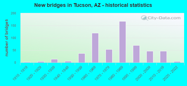
- New bridges - historical statistics
- 21910-1919
- 51920-1929
- 141930-1939
- 61940-1949
- 371950-1959
- 1201960-1969
- 541970-1979
- 1671980-1989
- 701990-1999
- 472000-2009
- 462010-2019
- 52020-2022
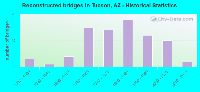
- Reconstructed bridges - Historical Statistics
- 31930-1939
- 11940-1949
- 41950-1959
- 151960-1969
- 141970-1979
- 181980-1989
- 121990-1999
- 102000-2009
- 22010-2019
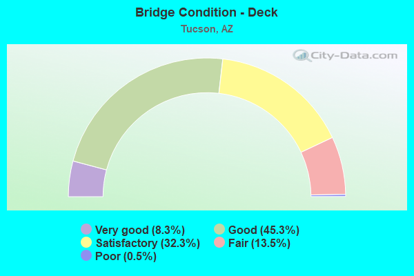
- Bridge Condition - Deck
- 8.3%Very good
- 45.3%Good
- 32.3%Satisfactory
- 13.5%Fair
- 0.5%Poor
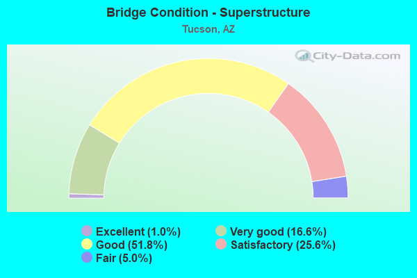
- Bridge Condition - Superstructure
- 1.0%Excellent
- 16.6%Very good
- 51.8%Good
- 25.6%Satisfactory
- 5.0%Fair
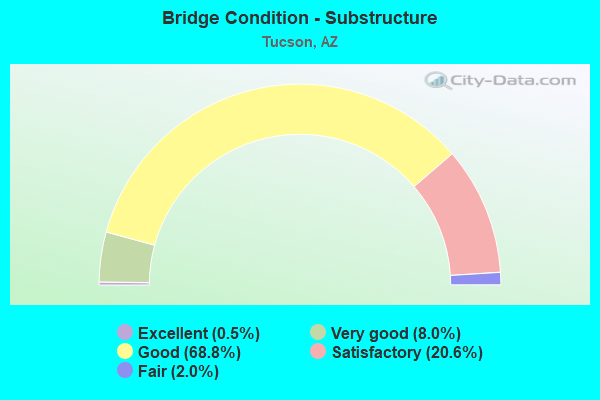
- Bridge Condition - Substructure
- 0.5%Excellent
- 8.0%Very good
- 68.8%Good
- 20.6%Satisfactory
- 2.0%Fair
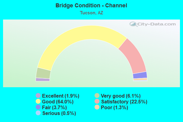
- Bridge Condition - Channel
- 1.9%Excellent
- 6.1%Very good
- 64.0%Good
- 22.5%Satisfactory
- 3.7%Fair
- 1.3%Poor
- 0.5%Serious
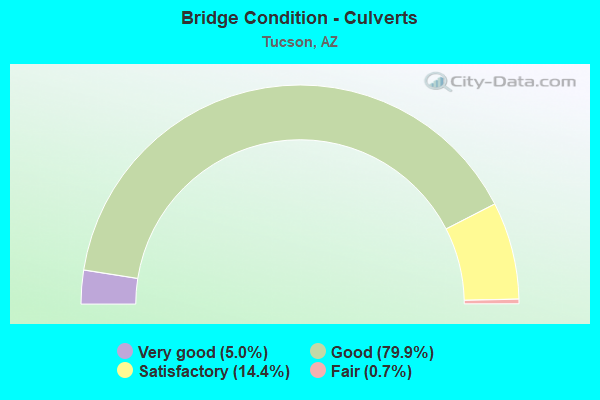
- Bridge Condition - Culverts
- 5.0%Very good
- 79.9%Good
- 14.4%Satisfactory
- 0.7%Fair
Find on map >> Show street view
Structure Number: AF49ACHA000131, Location: SITE 1 SOUTH ACCESS SECUR (Lat: 32.093264, Lng: -110.943256), Route carried "on" structure: ServiceOther road , Year Built: 1954, Status: Open, Structure Length: 1.75m (5.74ft), Average Daily Traffic: 6,000 (year 2017), Average Future Daily Traffic: 7,200 (year 2037), Features Intersected: DRAINAGE DITCH, Facility Carried by Structure: SITE 1 SOUTH ACCES
Minimum Vertical Clearance: 30+ m (98+ ft), Kilometerpoint: 0.000, Lanes on structure: 3, Owner: Air Force, Approaching Roadway Width: 7.8m (25.6ft), Material/Design: Steel, Design/Construction: Culvert, Number Of Spans In Main Unit: 10, Length of Maximum Span: 1.2m (3.9ft), Curb-To-Curb Width: 7.8m (25.6ft)
Condition: Channel: Good, Culverts: Good, Structural Evaluation: Better than present minimum criteria, Deck Geometry: High priority of replacement, Waterway Adequacy: Better than present minimum criteria, Approach Roadway Alignment: Equal to present desirable criteria, Designated Inspection Frequency: Every 24 months, Inspection Date: October 2021, Bridge Improvement Cost: $15,000, Roadway Improvement Cost: $2,000, Total Project Cost: $27,000 ( Estimate for 2017)
Find on map >> Show street view
Structure Number: AF49ACHA0001311, Location: SITE 2 S. ACCESS INTERSEC (Lat: 32.099889, Lng: -110.943222), Route carried "on" structure: ServiceOther road , Year Built: 1954, Status: Open, Structure Length: 0.97m (3.18ft), Average Daily Traffic: 6,000 (year 2017), Truck Traffic: 20%, Average Future Daily Traffic: 7,200 (year 2037), Features Intersected: DRAINAGE DITCH, Facility Carried by Structure: SITE 2 SOUTH ACCES
Minimum Vertical Clearance: 30+ m (98+ ft), Kilometerpoint: 0.000, Lanes on structure: 2, Owner: Air Force, Approaching Roadway Width: 7.6m (24.9ft), Skew: 10 degrees, Material/Design: Concrete, Design/Construction: Frame, Number Of Spans In Main Unit: 3, Length of Maximum Span: 3.0m (9.8ft), Curb-To-Curb Width: 13.8m (45.3ft), Out-to-Out Width: 24.2m (79.4ft)
Condition: Deck: Good, Superstructure: Good, Substructure: Good, Channel: Good, Operating Rating: 36.3 metric tons, Method Used To Determine Operating Rating: No rating analysis performed, Inventory Rating: 32.7 metric tons, Method Used To Determine Inventory Rating: No rating analysis performed, Structural Evaluation: Better than present minimum criteria, Deck Geometry: Superior to present desirable criteria, Waterway Adequacy: Better than present minimum criteria, Approach Roadway Alignment: Equal to present minimum criteria, Designated Inspection Frequency: Every 24 months, Inspection Date: October 2021, Deck Structure Type: Concrete Cast-file-Place, Wearing Surface/Protective System: Wearing Surface: Monolithic Concrete
Find on map >> Show street view
Structure Number: AF49ACHA0001312, Location: SITE 3 TANK FARM EAST ACC (Lat: 32.099967, Lng: -110.943642), Route carried "on" structure: ServiceOther road , Year Built: 1994, Status: Open, Structure Length: 0.97m (3.18ft), Average Daily Traffic: 10 (year 2017), Average Future Daily Traffic: 12 (year 2037), Features Intersected: DRAINAGE DITCH, Facility Carried by Structure: SITE 3 BLDG. 815 T
Minimum Vertical Clearance: 30+ m (98+ ft), Kilometerpoint: 0.000, Lanes on structure: 2, Owner: Air Force, Approaching Roadway Width: 5.6m (18.4ft), Material/Design: Concrete, Design/Construction: Frame, Number Of Spans In Main Unit: 3, Length of Maximum Span: 3.0m (9.8ft), Curb-To-Curb Width: 5.6m (18.4ft), Out-to-Out Width: 6.1m (20.0ft)
Condition: Deck: Good, Superstructure: Good, Substructure: Good, Channel: Good, Operating Rating: 36.3 metric tons, Method Used To Determine Operating Rating: No rating analysis performed, Inventory Rating: 32.7 metric tons, Method Used To Determine Inventory Rating: No rating analysis performed, Structural Evaluation: Better than present minimum criteria, Deck Geometry: Meets minimum limits, Waterway Adequacy: Better than present minimum criteria, Approach Roadway Alignment: Equal to present desirable criteria, Designated Inspection Frequency: Every 24 months, Inspection Date: October 2021, Deck Structure Type: Concrete Cast-file-Place, Wearing Surface/Protective System: Wearing Surface: Monolithic Concrete
Find on map >> Show street view
Structure Number: AF49ACHA0001313, Location: SITE 4 TANK FARM WEST ACC (Lat: 32.099992, Lng: -110.945142), Route carried "on" structure: ServiceOther road , Year Built: 1994, Status: Open, Structure Length: 0.97m (3.18ft), Average Daily Traffic: 10 (year 2017), Average Future Daily Traffic: 12 (year 2037), Features Intersected: DRAINAGE DITCH, Facility Carried by Structure: SITE 4 BLDG. 815 T
Minimum Vertical Clearance: 30+ m (98+ ft), Kilometerpoint: 0.000, Lanes on structure: 2, Owner: Air Force, Approaching Roadway Width: 5.6m (18.4ft), Material/Design: Concrete, Design/Construction: Frame, Number Of Spans In Main Unit: 3, Length of Maximum Span: 3.0m (9.8ft), Curb-To-Curb Width: 5.6m (18.4ft), Out-to-Out Width: 6.1m (20.0ft)
Condition: Deck: Satisfactory, Superstructure: Satisfactory, Substructure: Satisfactory, Channel: Fair, Operating Rating: 36.3 metric tons, Method Used To Determine Operating Rating: No rating analysis performed, Inventory Rating: 32.7 metric tons, Method Used To Determine Inventory Rating: No rating analysis performed, Structural Evaluation: Equal to present minimum criteria, Deck Geometry: Meets minimum limits, Waterway Adequacy: Better than present minimum criteria, Approach Roadway Alignment: Equal to present desirable criteria, Designated Inspection Frequency: Every 24 months, Inspection Date: October 2021, Deck Structure Type: Concrete Cast-file-Place, Wearing Surface/Protective System: Wearing Surface: Bituminous
Find on map >> Show street view
Structure Number: AF49ACHA00BRHR, Location: SITE 5 HERMANS RD FRM BLD (Lat: 32.105203, Lng: -110.951089), Route carried "on" structure: ServiceOther road , Year Built: 1954, Status: Open, Structure Length: 0.93m (3.05ft), Average Daily Traffic: 6,000 (year 2017), Average Future Daily Traffic: 7,200 (year 2037), Features Intersected: DRAINAGE DITCH, Facility Carried by Structure: SITE 5 BLDG 844 TO
Minimum Vertical Clearance: 30+ m (98+ ft), Kilometerpoint: 0.000, Lanes on structure: 4, Owner: Air Force, Approaching Roadway Width: 14.2m (46.6ft), Skew: 4 degrees, Material/Design: Concrete, Design/Construction: Frame, Number Of Spans In Main Unit: 2, Length of Maximum Span: 4.5m (14.8ft), Curb-To-Curb Width: 14.9m (48.9ft), Out-to-Out Width: 16.6m (54.5ft)
Condition: Deck: Satisfactory, Superstructure: Satisfactory, Substructure: Satisfactory, Channel: Satisfactory, Operating Rating: 36.3 metric tons, Method Used To Determine Operating Rating: No rating analysis performed, Inventory Rating: 32.7 metric tons, Method Used To Determine Inventory Rating: No rating analysis performed, Structural Evaluation: Equal to present minimum criteria, Deck Geometry: High priority of replacement, Waterway Adequacy: Better than present minimum criteria, Approach Roadway Alignment: Equal to present desirable criteria, Designated Inspection Frequency: Every 24 months, Inspection Date: October 2021, Deck Structure Type: Concrete Cast-file-Place, Wearing Surface/Protective System: Wearing Surface: Bituminous
Find on map >> Show street view
Structure Number: AFAZXHEA00091, Location: JUST NORTH OF MAIN ENTRAN (Lat: 32.133667, Lng: -110.949111), Route carried "on" structure: Other road , Year Built: 1989, Status: Open, Structure Length: 3.08m (10.10ft), Average Daily Traffic: 500 (year 2014), Average Future Daily Traffic: 600 (year 2034), Design Load: HS 20, Features Intersected: AIRPORT WASH, Facility Carried by Structure: S AIR GUARD WAY
Minimum Vertical Clearance: 5.87m (19.26ft), Kilometerpoint: 0.000, Lanes on structure: 3, Owner: Air Force, Approaching Roadway Width: 10.4m (34.1ft), Material/Design: Prestressed concrete, Design/Construction: Slab, Number Of Spans In Main Unit: 2, Length of Maximum Span: 15.2m (49.9ft), Curb-To-Curb Width: 10.4m (34.1ft), Out-to-Out Width: 11.0m (36.1ft)
Condition: Deck: Satisfactory, Superstructure: Good, Substructure: Satisfactory, Channel: Good, Operating Rating: 36.3 metric tons, Method Used To Determine Operating Rating: Field evaluation and documented engineering judgment, Inventory Rating: 32.7 metric tons, Method Used To Determine Inventory Rating: Field evaluation and documented engineering judgment, Structural Evaluation: Equal to present minimum criteria, Deck Geometry: High priority of replacement, Waterway Adequacy: Equal to present desirable criteria, Approach Roadway Alignment: Equal to present desirable criteria, Designated Inspection Frequency: Every 24 months, Inspection Date: September 2020, Deck Structure Type: Concrete Precast Panels, Wearing Surface/Protective System: Wearing Surface: Bituminous
Find on map >> Show street view
Structure Number: 596, Location: 9.0 mi E Jct I-19 (Lat: 32.114492, Lng: -110.858211), Route carried "under" structure: County highway , Year Built: 1960, Structure Length: 0. m, Average Daily Traffic: 1,802 (year 2017), Truck Traffic: 5%, Features Intersected: Wilmot Rd, Facility Carried by Structure: I-10 EB
Minimum Vertical Clearance: 4.79m (15.72ft), Kilometerpoint: 0.000, Lanes on structure: 2, Lanes under structure: 4, Material/Design: Prestressed concrete, Design/Construction: Stringer/Multi-beam, Length of Maximum Span: 15.5m (50.9ft)
Find on map >> Show street view
Structure Number: 597, Location: 9.0 mi E Jct I-19 (Lat: 32.114803, Lng: -110.858206), Route carried "under" structure: County highway , Year Built: 1960, Structure Length: 0. m, Average Daily Traffic: 1,802 (year 2017), Truck Traffic: 5%, Features Intersected: Wilmot Rd, Facility Carried by Structure: I-10 WB
Minimum Vertical Clearance: 4.68m (15.35ft), Kilometerpoint: 0.000, Lanes on structure: 2, Lanes under structure: 4, Material/Design: Prestressed concrete, Design/Construction: Stringer/Multi-beam, Length of Maximum Span: 15.5m (50.9ft)
Find on map >> Show street view
Structure Number: 711, Location: 12.8 mi E Jct I-19 (Lat: 32.082100, Lng: -110.805700), Route carried "under" structure: Interstate 10, Year Built: 1962, Structure Length: 0. m, Average Daily Traffic: 62,220 (year 2019), Truck Traffic: 16%, Features Intersected: I 10, Facility Carried by Structure: Rita Road
Minimum Vertical Clearance: 4.99m (16.37ft), Kilometerpoint: 439.576, Lanes on structure: 2, Lanes under structure: 4, Material/Design: Steel continuous, Design/Construction: Stringer/Multi-beam, Length of Maximum Span: 21.0m (68.9ft)
Find on map >> Show street view
Structure Number: 87, Location: 9.2 mi N Jct I-19 (Lat: 32.309200, Lng: -111.042100), Route carried "under" structure: City street , Year Built: 1966, Structure Length: 0. m, Average Daily Traffic: 1,000 (year 2018), Truck Traffic: 5%, Features Intersected: Sunset Road, Facility Carried by Structure: I 10; EB
Minimum Vertical Clearance: 4.42m (14.50ft), Kilometerpoint: 0.000, Lanes on structure: 3, Lanes under structure: 2, Material/Design: Prestressed concrete, Design/Construction: Stringer/Multi-beam, Length of Maximum Span: 19.2m (63.0ft)
Find on map >> Show street view
Structure Number: 871, Location: 9.2 mi N Jct I-19 (Lat: 32.309300, Lng: -111.041800), Route carried "under" structure: City street , Year Built: 1966, Structure Length: 0. m, Average Daily Traffic: 1,000 (year 2018), Truck Traffic: 5%, Features Intersected: Sunset Road, Facility Carried by Structure: I 10; WB
Minimum Vertical Clearance: 4.45m (14.60ft), Kilometerpoint: 0.000, Lanes on structure: 3, Lanes under structure: 2, Material/Design: Prestressed concrete, Design/Construction: Stringer/Multi-beam, Length of Maximum Span: 19.2m (63.0ft)
Find on map >> Show street view
Structure Number: 1107, Location: 2.0 mi East Jct I 19 (Lat: 32.178100, Lng: -110.946400), Route carried "under" structure: City street , Year Built: 1965, Structure Length: 0. m, Average Daily Traffic: 24,600 (year 2020), Truck Traffic: 5%, Features Intersected: Ajo Way, Facility Carried by Structure: I 10; EB
Minimum Vertical Clearance: 4.58m (15.03ft), Kilometerpoint: 0.000, Lanes on structure: 2, Lanes under structure: 4, Material/Design: Steel continuous, Design/Construction: Stringer/Multi-beam, Length of Maximum Span: 22.6m (74.1ft)
Find on map >> Show street view
Structure Number: 1108, Location: 2.0 mi E Jct I 19 (Lat: 32.178100, Lng: -110.945600), Route carried "under" structure: City street , Year Built: 1965, Structure Length: 0. m, Average Daily Traffic: 24,600 (year 2020), Truck Traffic: 5%, Features Intersected: Ajo Way; FAU 8173, Facility Carried by Structure: I 10; WB
Minimum Vertical Clearance: 4.60m (15.09ft), Kilometerpoint: 0.000, Lanes on structure: 2, Lanes under structure: 4, Material/Design: Steel continuous, Design/Construction: Stringer/Multi-beam, Length of Maximum Span: 22.6m (74.1ft)
Find on map >> Show street view
Structure Number: 1111, Location: 3.5 mi E Jct I 19 (Lat: 32.167000, Lng: -110.926500), Route carried "under" structure: City street , Year Built: 1966, Structure Length: 0. m, Average Daily Traffic: 7,300 (year 2020), Truck Traffic: 5%, Features Intersected: Country Club Road, Facility Carried by Structure: I 10; EB
Minimum Vertical Clearance: 4.39m (14.40ft), Kilometerpoint: 0.000, Lanes on structure: 2, Lanes under structure: 2, Material/Design: Steel continuous, Design/Construction: Stringer/Multi-beam, Length of Maximum Span: 22.9m (75.1ft)
Find on map >> Show street view
Structure Number: 1112, Location: 3.5 mi E Jct I 19 (Lat: 32.167400, Lng: -110.926500), Route carried "under" structure: City street , Year Built: 1966, Structure Length: 0. m, Average Daily Traffic: 7,300 (year 2020), Truck Traffic: 5%, Features Intersected: Country Club Road, Facility Carried by Structure: I 10; WB
Minimum Vertical Clearance: 4.54m (14.90ft), Kilometerpoint: 0.000, Lanes on structure: 2, Lanes under structure: 2, Material/Design: Steel continuous, Design/Construction: Stringer/Multi-beam, Length of Maximum Span: 22.9m (75.1ft)
Find on map >> Show street view
Structure Number: 112, Location: 3.1 mi S Jct I-10 (Lat: 32.148600, Lng: -110.987100), Route carried "under" structure: Interstate 19, Year Built: 1965, Structure Length: 0. m, Average Daily Traffic: 72,134 (year 2019), Truck Traffic: 14%, Features Intersected: I 19, Facility Carried by Structure: Drexel Road
Minimum Vertical Clearance: 5.41m (17.75ft), Kilometerpoint: 96.400, Lanes on structure: 2, Lanes under structure: 2, Material/Design: Steel continuous, Design/Construction: Stringer/Multi-beam, Length of Maximum Span: 23.8m (78.1ft)
Find on map >> Show street view
Structure Number: 1123, Location: Irvington Road (Lat: 32.163300, Lng: -110.986000), Route carried "under" structure: Interstate 19, Year Built: 1965, Structure Length: 0. m, Average Daily Traffic: 89,004 (year 2019), Truck Traffic: 10%, Features Intersected: I 19, Facility Carried by Structure: Irvington Road
Minimum Vertical Clearance: 5.15m (16.90ft), Kilometerpoint: 98.090, Lanes on structure: 5, Lanes under structure: 5, Material/Design: Steel continuous, Design/Construction: Stringer/Multi-beam, Length of Maximum Span: 23.8m (78.1ft)
Find on map >> Show street view
Structure Number: 1162, Location: 2.1 mi E Jct I-19 (Lat: 32.176800, Lng: -110.944300), Route carried "under" structure: Interstate 10, Year Built: 1967, Structure Length: 0. m, Average Daily Traffic: 85,609 (year 2017), Truck Traffic: 19%, Features Intersected: I 10; Ajo Way, Facility Carried by Structure: Kino Parkway
Minimum Vertical Clearance: 5.17m (16.96ft), Kilometerpoint: 422.501, Lanes on structure: 3, Lanes under structure: 9, Material/Design: Concrete continuous, Design/Construction: Box Beam or Girders - Single/Spread, Length of Maximum Span: 31.7m (104.0ft)
Find on map >> Show street view
Structure Number: 1163, Location: 2.1 mi E Jct I-19 (Lat: 32.176900, Lng: -110.944700), Route carried "under" structure: Interstate 10, Year Built: 1967, Structure Length: 0. m, Average Daily Traffic: 85,609 (year 2017), Truck Traffic: 19%, Features Intersected: I 10; and Ajo Way, Facility Carried by Structure: Kino Pkwy SB
Minimum Vertical Clearance: 5.49m (18.01ft), Kilometerpoint: 422.501, Lanes on structure: 3, Lanes under structure: 9, Material/Design: Concrete continuous, Design/Construction: Box Beam or Girders - Single/Spread, Length of Maximum Span: 31.7m (104.0ft)
Find on map >> Show street view
Structure Number: 1217, Location: 3.9 mi E Jct I 19 (Lat: 32.163400, Lng: -110.920200), Route carried "under" structure: City street , Year Built: 1967, Structure Length: 0. m, Average Daily Traffic: 18,972 (year 2018), Truck Traffic: 5%, Features Intersected: Irvington Road, Facility Carried by Structure: I 10; EB
Minimum Vertical Clearance: 4.90m (16.08ft), Kilometerpoint: 0.000, Lanes on structure: 3, Lanes under structure: 4, Material/Design: Steel continuous, Design/Construction: Stringer/Multi-beam, Length of Maximum Span: 22.6m (74.1ft)
Find on map >> Show street view
Structure Number: 1218, Location: 3.9 mi E Jct I 19 (Lat: 32.163400, Lng: -110.919400), Route carried "under" structure: City street , Year Built: 1967, Structure Length: 0. m, Average Daily Traffic: 18,972 (year 2018), Truck Traffic: 5%, Features Intersected: FAU 8251; Irvington Rd, Facility Carried by Structure: I 10; WB
Minimum Vertical Clearance: 4.95m (16.24ft), Kilometerpoint: 0.000, Lanes on structure: 2, Lanes under structure: 4, Material/Design: Steel continuous, Design/Construction: Stringer/Multi-beam, Length of Maximum Span: 22.6m (74.1ft)
Find on map >> Show street view
Structure Number: 1219, Location: 4.0 mi E Jct I 19 (Lat: 32.162100, Lng: -110.917900), Route carried "under" structure: City street , Year Built: 1965, Structure Length: 0. m, Average Daily Traffic: 20,784 (year 2017), Truck Traffic: 5%, Features Intersected: Palo Verde Road, Facility Carried by Structure: I 10; EB
Minimum Vertical Clearance: 4.46m (14.63ft), Kilometerpoint: 0.000, Lanes on structure: 3, Lanes under structure: 6, Material/Design: Steel continuous, Design/Construction: Stringer/Multi-beam, Length of Maximum Span: 18.9m (62.0ft)
Find on map >> Show street view
Structure Number: 122, Location: 4.0 mi E Jct I 19 (Lat: 32.162500, Lng: -110.917900), Route carried "under" structure: City street , Year Built: 1967, Structure Length: 0. m, Average Daily Traffic: 20,784 (year 2017), Truck Traffic: 5%, Features Intersected: Palo Verde Road, Facility Carried by Structure: I 10; WB
Minimum Vertical Clearance: 4.71m (15.45ft), Kilometerpoint: 0.000, Lanes on structure: 2, Lanes under structure: 2, Material/Design: Steel continuous, Design/Construction: Stringer/Multi-beam, Length of Maximum Span: 18.9m (62.0ft)
Find on map >> Show street view
Structure Number: 1224, Location: 5.6 mi E Jct I-19 (Lat: 32.149097, Lng: -110.896069), Route carried "under" structure: County highway , Year Built: 1967, Structure Length: 0. m, Average Daily Traffic: 660 (year 2016), Truck Traffic: 10%, Features Intersected: Drexel Rd, Facility Carried by Structure: I-10 WB
Minimum Vertical Clearance: 4.65m (15.26ft), Kilometerpoint: 0.000, Lanes on structure: 2, Lanes under structure: 2, Material/Design: Prestressed concrete, Design/Construction: Stringer/Multi-beam, Length of Maximum Span: 16.8m (55.1ft)
Find on map >> Show street view
Structure Number: 1226, Location: 6.7 mi E Jct I-19 (Lat: 32.134547, Lng: -110.887542), Route carried "under" structure: County highway , Year Built: 1967, Structure Length: 0. m, Average Daily Traffic: 10,164 (year 2014), Truck Traffic: 5%, Features Intersected: Valencia Road, Facility Carried by Structure: I-10 WB
Minimum Vertical Clearance: 5.08m (16.67ft), Kilometerpoint: 0.000, Lanes on structure: 2, Lanes under structure: 6, Material/Design: Prestressed concrete, Design/Construction: Stringer/Multi-beam, Length of Maximum Span: 18.3m (60.0ft)
Find on map >> Show street view
Structure Number: 1241, Location: 7.3 mi South Jct I 19 (Lat: 32.090200, Lng: -110.993100), Route carried "under" structure: Federal lands road , Year Built: 1967, Structure Length: 0. m, Average Daily Traffic: 100 (year 2018), Truck Traffic: 1%, Features Intersected: San Xavier Rd., Facility Carried by Structure: IRR I 19; NB
Minimum Vertical Clearance: 4.34m (14.24ft), Kilometerpoint: 0.000, Lanes on structure: 2, Lanes under structure: 2, Material/Design: Concrete continuous, Design/Construction: Slab, Length of Maximum Span: 7.6m (24.9ft)
Find on map >> Show street view
Structure Number: 1242, Location: 7.3 mi South of Jct I 19 (Lat: 32.090200, Lng: -110.993500), Route carried "under" structure: Federal lands road , Year Built: 1967, Structure Length: 0. m, Average Daily Traffic: 100 (year 2018), Truck Traffic: 1%, Features Intersected: San Xavier Rd, Facility Carried by Structure: IRR I 19; SB
Minimum Vertical Clearance: 4.81m (15.78ft), Kilometerpoint: 0.000, Lanes on structure: 2, Lanes under structure: 2, Material/Design: Concrete continuous, Design/Construction: Slab, Length of Maximum Span: 7.6m (24.9ft)
Find on map >> Show street view
Structure Number: 1245, Location: 6.2 mi South Jct I10 (Lat: 32.106800, Lng: -110.992600), Route carried "under" structure: County highway , Year Built: 1967, Structure Length: 0. m, Average Daily Traffic: 5,945 (year 2020), Truck Traffic: 10%, Features Intersected: San Xavier Mission Road, Facility Carried by Structure: IRR I 19; NB
Minimum Vertical Clearance: 4.77m (15.65ft), Kilometerpoint: 0.000, Lanes on structure: 2, Lanes under structure: 2, Material/Design: Steel continuous, Design/Construction: Stringer/Multi-beam, Length of Maximum Span: 30.3m (99.4ft)
Find on map >> Show street view
Structure Number: 1246, Location: 6.2 mi South of Jct I-10 (Lat: 32.106500, Lng: -110.993000), Route carried "under" structure: County highway , Year Built: 1967, Structure Length: 0. m, Average Daily Traffic: 5,945 (year 2020), Truck Traffic: 10%, Features Intersected: San Xavier Mission Road, Facility Carried by Structure: IRR I 19; SB
Minimum Vertical Clearance: 4.79m (15.72ft), Kilometerpoint: 0.000, Lanes on structure: 2, Lanes under structure: 2, Material/Design: Steel continuous, Design/Construction: Stringer/Multi-beam, Length of Maximum Span: 30.2m (99.1ft)
Find on map >> Show street view
Structure Number: 1823, Location: 10.2 mi E Jct I-19 (Lat: 32.103500, Lng: -110.841000), Route carried "under" structure: Interstate 10, Year Built: 1986, Structure Length: 0. m, Average Daily Traffic: 55,590 (year 2018), Truck Traffic: 17%, Features Intersected: I-10, Facility Carried by Structure: Kolb Road
Minimum Vertical Clearance: 5.19m (17.03ft), Kilometerpoint: 435.456, Lanes on structure: 4, Lanes under structure: 4, Material/Design: Prestressed concrete continuous, Design/Construction: Stringer/Multi-beam, Length of Maximum Span: 41.5m (136.2ft)
Find on map >> Show street view
Structure Number: 1943, Location: 4.0 miles S of I-10 jct (Lat: 32.134000, Lng: -110.986800), Route carried "under" structure: Interstate 19, Year Built: 2002, Structure Length: 0. m, Average Daily Traffic: 72,635 (year 2018), Truck Traffic: 19%, Features Intersected: Interstate 19, Facility Carried by Structure: Valencia Road
Minimum Vertical Clearance: 5.76m (18.90ft), Kilometerpoint: 94.662, Lanes on structure: 8, Lanes under structure: 10, Material/Design: Prestressed concrete continuous, Design/Construction: Stringer/Multi-beam, Length of Maximum Span: 30.5m (100.1ft)
Find on map >> Show street view
Structure Number: 2012, Location: 2.0 mi E Jct I-19 (Lat: 32.178100, Lng: -110.947300), Route carried "under" structure: City street , Year Built: 1987, Structure Length: 0. m, Average Daily Traffic: 30,000 (year 2018), Truck Traffic: 5%, Features Intersected: Ajo Way, Facility Carried by Structure: I 10 Off Ramp
Minimum Vertical Clearance: 5.96m (19.55ft), Kilometerpoint: 0.000, Lanes on structure: 1, Lanes under structure: 4, Material/Design: Prestressed concrete continuous, Design/Construction: Box Beam or Girders - Single/Spread, Length of Maximum Span: 28.0m (91.9ft)
Find on map >> Show street view
Structure Number: 2018, Location: 4.7 mi E Jct I-19 (Lat: 32.157456, Lng: -110.909558), Route carried "under" structure: County highway , Year Built: 1987, Structure Length: 0. m, Average Daily Traffic: 23,892 (year 2016), Truck Traffic: 5%, Features Intersected: Alvernon Way, Facility Carried by Structure: I-10 EB
Minimum Vertical Clearance: 5.56m (18.24ft), Kilometerpoint: 0.000, Lanes on structure: 2, Lanes under structure: 2, Material/Design: Prestressed concrete continuous, Design/Construction: Box Beam or Girders - Single/Spread, Length of Maximum Span: 32.0m (105.0ft)
Find on map >> Show street view
Structure Number: 2019, Location: 4.7 mi E Jct I-19 (Lat: 32.157800, Lng: -110.909500), Route carried "under" structure: County highway , Year Built: 1987, Structure Length: 0. m, Average Daily Traffic: 23,812 (year 2016), Truck Traffic: 5%, Features Intersected: Alvernon Way, Facility Carried by Structure: I-10 WB
Minimum Vertical Clearance: 5.50m (18.04ft), Kilometerpoint: 0.000, Lanes on structure: 2, Lanes under structure: 2, Material/Design: Prestressed concrete continuous, Design/Construction: Box Beam or Girders - Single/Spread, Length of Maximum Span: 32.0m (105.0ft)
Find on map >> Show street view
Structure Number: 2146, Location: 1.6 mi E Jct I 10 (Lat: 32.216667, Lng: -110.961111), Route carried "under" structure: City street , Year Built: 1998, Structure Length: 0. m, Average Daily Traffic: 18,224 (year 2017), Truck Traffic: 10%, Features Intersected: Euclid/Park Ave, Facility Carried by Structure: SR 210 EB
Minimum Vertical Clearance: 7.10m (23.29ft), Kilometerpoint: 0.000, Lanes on structure: 4, Lanes under structure: 4, Material/Design: Prestressed concrete continuous, Design/Construction: Box Beam or Girders - Single/Spread, Length of Maximum Span: 39.6m (129.9ft)
Find on map >> Show street view
Structure Number: 2147, Location: 1.6 mi E Jct I 10 (Lat: 32.216667, Lng: -110.961111), Route carried "under" structure: City street , Year Built: 1998, Structure Length: 0. m, Average Daily Traffic: 18,224 (year 2017), Truck Traffic: 10%, Features Intersected: Euclid/Park Ave, Facility Carried by Structure: SR 210 WB
Minimum Vertical Clearance: 5.74m (18.83ft), Kilometerpoint: 0.000, Lanes on structure: 4, Lanes under structure: 4, Material/Design: Prestressed concrete continuous, Design/Construction: Box Beam or Girders - Single/Spread, Length of Maximum Span: 43.9m (144.0ft)
Find on map >> Show street view
Structure Number: 2162, Location: 1.3 mi E Jct I-19 (Lat: 32.183700, Lng: -110.956600), Route carried "under" structure: City street , Year Built: 1991, Structure Length: 0. m, Average Daily Traffic: 19,865 (year 2015), Truck Traffic: 5%, Features Intersected: Park Avenue, Facility Carried by Structure: I 10 EB
Minimum Vertical Clearance: 5.53m (18.14ft), Kilometerpoint: 0.000, Lanes on structure: 4, Lanes under structure: 8, Material/Design: Prestressed concrete continuous, Design/Construction: Stringer/Multi-beam, Length of Maximum Span: 28.7m (94.2ft)
Find on map >> Show street view
Structure Number: 2163, Location: 1.3 mi E Jct I-19 (Lat: 32.184000, Lng: -110.956600), Route carried "under" structure: City street , Year Built: 1992, Structure Length: 0. m, Average Daily Traffic: 19,865 (year 2015), Truck Traffic: 5%, Features Intersected: Park Avenue, Facility Carried by Structure: I 10 WB
Minimum Vertical Clearance: 6.22m (20.41ft), Kilometerpoint: 0.000, Lanes on structure: 4, Lanes under structure: 4, Material/Design: Prestressed concrete continuous, Design/Construction: Stringer/Multi-beam, Length of Maximum Span: 28.3m (92.8ft)
Find on map >> Show street view
Structure Number: 2164, Location: 1.0 mi E Jct I-19 (Lat: 32.185800, Lng: -110.961700), Route carried "under" structure: City street , Year Built: 1991, Structure Length: 0. m, Average Daily Traffic: 1,100 (year 2017), Truck Traffic: 5%, Features Intersected: Loop Road and SPRR, Facility Carried by Structure: WB Frontage Road
Minimum Vertical Clearance: 4.59m (15.06ft), Kilometerpoint: 0.000, Lanes on structure: 2, Lanes under structure: 1, Material/Design: Prestressed concrete continuous, Design/Construction: Stringer/Multi-beam, Length of Maximum Span: 16.8m (55.1ft)
Find on map >> Show street view
Structure Number: 2186, Location: 2.7 mi N Jct I-19 (Lat: 32.229700, Lng: -110.982500), Route carried "under" structure: City street , Year Built: 2009, Structure Length: 0. m, Average Daily Traffic: 35,000 (year 2018), Truck Traffic: 5%, Features Intersected: St. Mary's Rd, Facility Carried by Structure: I-10
Minimum Vertical Clearance: 5.36m (17.59ft), Kilometerpoint: 0.000, Lanes on structure: 10, Lanes under structure: 6, Material/Design: Prestressed concrete continuous, Design/Construction: Stringer/Multi-beam, Length of Maximum Span: 31.7m (104.0ft)
Find on map >> Show street view
Structure Number: 2194, Location: 0.2 mi E Jct I-19 (Lat: 32.190442, Lng: -110.974806), Route carried "under" structure: City street , Year Built: 1991, Structure Length: 0. m, Average Daily Traffic: 6,700 (year 2018), Truck Traffic: 1%, Features Intersected: 10th Avenue, Facility Carried by Structure: I 10
Minimum Vertical Clearance: 4.64m (15.22ft), Kilometerpoint: 0.000, Lanes on structure: 8, Lanes under structure: 2, Material/Design: Prestressed concrete continuous, Design/Construction: Box Beam or Girders - Single/Spread, Length of Maximum Span: 26.8m (87.9ft)
Find on map >> Show street view
Structure Number: 2195, Location: 0.8 mi SE Jct I-19 (Lat: 32.186800, Lng: -110.968300), Route carried "under" structure: Interstate 10, Year Built: 1990, Structure Length: 0. m, Average Daily Traffic: 117,146 (year 2017), Truck Traffic: 19%, Features Intersected: I 10, Facility Carried by Structure: B 19
Minimum Vertical Clearance: 5.28m (17.32ft), Kilometerpoint: 420.023, Lanes on structure: 6, Lanes under structure: 6, Material/Design: Prestressed concrete continuous, Design/Construction: Stringer/Multi-beam, Length of Maximum Span: 31.1m (102.0ft)
Find on map >> Show street view
Structure Number: 2196, Location: 1.0 mi E Jct I-19 (Lat: 32.185100, Lng: -110.961700), Route carried "under" structure: City street , Year Built: 1991, Structure Length: 0. m, Average Daily Traffic: 1,100 (year 2017), Truck Traffic: 5%, Features Intersected: SPRR and EB Loop Road, Facility Carried by Structure: I 10 EB Fr Road
Minimum Vertical Clearance: 4.49m (14.73ft), Kilometerpoint: 420.699, Lanes on structure: 3, Lanes under structure: 1, Material/Design: Prestressed concrete continuous, Design/Construction: Stringer/Multi-beam, Length of Maximum Span: 16.8m (55.1ft)
Find on map >> Show street view
Structure Number: 2197, Location: 1.0 mi E of Jct I 19 (Lat: 32.185400, Lng: -110.961700), Route carried "under" structure: Ramp City street , Year Built: 1991, Structure Length: 0. m, Average Daily Traffic: 562 (year 2020), Truck Traffic: 2%, Features Intersected: SPRR & 4th Ave Ramp, Facility Carried by Structure: I 10; EB & WB
Minimum Vertical Clearance: 4.53m (14.86ft), Kilometerpoint: 0.000, Lanes on structure: 6, Lanes under structure: 6, Material/Design: Steel continuous, Design/Construction: Stringer/Multi-beam, Length of Maximum Span: 19.5m (64.0ft)
Find on map >> Show street view
Structure Number: 2362, Location: Jct SR 77 (Lat: 32.260100, Lng: -111.003000), Route carried "under" structure: Interstate 10, Year Built: 1995, Structure Length: 0. m, Average Daily Traffic: 124,645 (year 2017), Truck Traffic: 19%, Features Intersected: I 10, Facility Carried by Structure: SR 77; Miracle Mil
Minimum Vertical Clearance: 6.46m (21.19ft), Kilometerpoint: 410.833, Lanes on structure: 4, Lanes under structure: 8, Material/Design: Prestressed concrete continuous, Design/Construction: Box Beam or Girders - Single/Spread, Length of Maximum Span: 38.1m (125.0ft)
Find on map >> Show street view
Structure Number: 2598, Location: Jct I-19 (Lat: 32.197900, Lng: -110.979300), Route carried "under" structure: Ramp Interstate 10, Year Built: 2003, Structure Length: 0. m, Average Daily Traffic: 1,500 (year 2017), Truck Traffic: 5%, Features Intersected: Ramp EB, Facility Carried by Structure: Ramp E-S
Minimum Vertical Clearance: 5.29m (17.36ft), Kilometerpoint: 418.413, Lanes on structure: 2, Lanes under structure: 2, Material/Design: Prestressed concrete continuous, Design/Construction: Box Beam or Girders - Single/Spread, Length of Maximum Span: 54.9m (180.1ft)
Find on map >> Show street view
Structure Number: 26, Location: 0.6 mi N Jct I-19 (Lat: 32.199700, Lng: -110.979300), Route carried "under" structure: City street , Year Built: 2004, Structure Length: 0. m, Average Daily Traffic: 11,500 (year 2018), Truck Traffic: 5%, Features Intersected: 29th Street, Facility Carried by Structure: I 10 EB
Minimum Vertical Clearance: 5.95m (19.52ft), Kilometerpoint: 0.000, Lanes on structure: 5, Lanes under structure: 6, Material/Design: Prestressed concrete continuous, Design/Construction: Box Beam or Girders - Single/Spread, Length of Maximum Span: 22.9m (75.1ft)
Find on map >> Show street view
Structure Number: 2601, Location: Jct I-19 (Lat: 32.197100, Lng: -110.978100), Route carried "under" structure: Interstate 10, Year Built: 2003, Structure Length: 0. m, Average Daily Traffic: 156,011 (year 2017), Truck Traffic: 19%, Features Intersected: I 10 Mainline
Minimum Vertical Clearance: 7.05m (23.13ft), Kilometerpoint: 418.719, Lanes on structure: 2, Lanes under structure: 8, Material/Design: Prestressed concrete continuous, Design/Construction: Box Beam or Girders - Single/Spread, Length of Maximum Span: 64.0m (210.0ft)
Find on map >> Show street view
Structure Number: 2602, Location: Jct I-10 & I-19 (Lat: 32.195700, Lng: -110.977200), Route carried "under" structure: Interstate 10, Year Built: 2003, Structure Length: 0. m, Average Daily Traffic: 156,011 (year 2017), Truck Traffic: 19%, Features Intersected: I 10, Facility Carried by Structure: I 19 Ramp N
Minimum Vertical Clearance: 6.56m (21.52ft), Kilometerpoint: 418.719, Lanes on structure: 1, Lanes under structure: 9, Material/Design: Prestressed concrete continuous, Design/Construction: Box Beam or Girders - Single/Spread, Length of Maximum Span: 36.6m (120.1ft)
Find on map >> Show street view
Structure Number: 2603, Location: Jct I-10 & I-19 (Lat: 32.195200, Lng: -110.977000), Route carried "under" structure: Interstate 10, Year Built: 2003, Structure Length: 0. m, Average Daily Traffic: 156,011 (year 2017), Truck Traffic: 19%, Features Intersected: I-10, Facility Carried by Structure: 12th to 29th Ramp
Minimum Vertical Clearance: 5.49m (18.01ft), Kilometerpoint: 418.719, Lanes on structure: 1, Lanes under structure: 8, Material/Design: Prestressed concrete continuous, Design/Construction: Box Beam or Girders - Single/Spread, Length of Maximum Span: 57.3m (188.0ft)
Find on map >> Show street view
Structure Number: 2604, Location: 0.6 mi N Jct I-19 (Lat: 32.199700, Lng: -110.979000), Route carried "under" structure: City street , Year Built: 2004, Structure Length: 0. m, Average Daily Traffic: 11,400 (year 2018), Truck Traffic: 5%, Features Intersected: 29th Street, Facility Carried by Structure: I 10 WB
Minimum Vertical Clearance: 5.18m (16.99ft), Kilometerpoint: 0.000, Lanes on structure: 5, Lanes under structure: 6, Material/Design: Prestressed concrete continuous, Design/Construction: Box Beam or Girders - Single/Spread, Length of Maximum Span: 22.9m (75.1ft)
Find on map >> Show street view
Structure Number: 2657, Location: 1 mi E Jct I 10 (Lat: 32.222222, Lng: -110.972222), Route carried "under" structure: State highway 210, Year Built: 1998, Structure Length: 0. m, Average Daily Traffic: 21,031 (year 2017), Truck Traffic: 7%, Features Intersected: Broadway Blvd, Facility Carried by Structure: Council/Toole Ave.
Minimum Vertical Clearance: 5.95m (19.52ft), Kilometerpoint: 1.529, Lanes on structure: 2, Lanes under structure: 2, Material/Design: Concrete continuous, Design/Construction: Box Beam or Girders - Single/Spread, Length of Maximum Span: 38.1m (125.0ft)
Find on map >> Show street view
Structure Number: 2658, Location: 1.0 mi E Jct I 10 (Lat: 32.220600, Lng: -110.963300), Route carried "under" structure: State highway 210, Year Built: 1998, Structure Length: 0. m, Average Daily Traffic: 21,031 (year 2017), Truck Traffic: 7%, Features Intersected: Broadway Blvd, Facility Carried by Structure: SPRR
Minimum Vertical Clearance: 5.64m (18.50ft), Kilometerpoint: 1.577, Lanes under structure: 7, Material/Design: Concrete continuous, Design/Construction: Box Beam or Girders - Single/Spread, Length of Maximum Span: 29.6m (97.1ft)
Find on map >> Show street view
Structure Number: 2659, Location: 1.6 mi E Jct I 10 (Lat: 32.215700, Lng: -110.956800), Route carried "under" structure: State highway 210, Year Built: 1998, Structure Length: 0. m, Average Daily Traffic: 21,031 (year 2017), Truck Traffic: 7%, Features Intersected: Euclid/Park Ave, Facility Carried by Structure: SPRR Mainline
Minimum Vertical Clearance: 6.75m (22.15ft), Kilometerpoint: 2.269, Lanes under structure: 4, Material/Design: Prestressed concrete continuous, Design/Construction: Box Beam or Girders - Single/Spread, Length of Maximum Span: 28.3m (92.8ft)
Find on map >> Show street view
Structure Number: 266, Location: 1.6 mi E Jct I 10 (Lat: 32.215300, Lng: -110.956700), Route carried "under" structure: State highway 210, Year Built: 1998, Structure Length: 0. m, Average Daily Traffic: 21,031 (year 2017), Truck Traffic: 7%, Features Intersected: Euclid/Park Ave, Facility Carried by Structure: SPRR Nogales
Minimum Vertical Clearance: 7.36m (24.15ft), Kilometerpoint: 2.285, Lanes under structure: 4, Material/Design: Prestressed concrete continuous, Design/Construction: Box Beam or Girders - Single/Spread, Length of Maximum Span: 22.3m (73.2ft)
Find on map >> Show street view
Structure Number: 2661, Location: 1.6 mi E Jct I 10 (Lat: 32.225000, Lng: -110.961111), Route carried "under" structure: State highway 210, Year Built: 1998, Structure Length: 0. m, Average Daily Traffic: 21,031 (year 2017), Truck Traffic: 7%, Features Intersected: Euclid/Park Ave, Facility Carried by Structure: 16th St/Mill St
Minimum Vertical Clearance: 6.71m (22.01ft), Kilometerpoint: 2.285, Lanes on structure: 2, Lanes under structure: 2, Material/Design: Prestressed concrete continuous, Design/Construction: Box Beam or Girders - Single/Spread, Length of Maximum Span: 21.6m (70.9ft)
Find on map >> Show street view
Structure Number: 2783, Location: 4.0 mi N Jct I-19 (Lat: 32.250600, Lng: -110.993300), Route carried "under" structure: City street , Year Built: 2009, Structure Length: 0. m, Average Daily Traffic: 37,000 (year 2018), Truck Traffic: 5%, Features Intersected: Grant Road, Facility Carried by Structure: I-10 EB & WB
Minimum Vertical Clearance: 5.38m (17.65ft), Kilometerpoint: 0.000, Lanes on structure: 8, Lanes under structure: 6, Material/Design: Prestressed concrete continuous, Design/Construction: Stringer/Multi-beam, Length of Maximum Span: 35.4m (116.1ft)
Find on map >> Show street view
Structure Number: 2784, Location: 5.0 mi N Jct I-19 (Lat: 32.236000, Lng: -110.984100), Route carried "under" structure: City street , Year Built: 2009, Structure Length: 0. m, Average Daily Traffic: 31,000 (year 2018), Truck Traffic: 5%, Features Intersected: Speedway Blvd., Facility Carried by Structure: I-10
Minimum Vertical Clearance: 5.29m (17.36ft), Kilometerpoint: 0.000, Lanes on structure: 8, Lanes under structure: 6, Material/Design: Prestressed concrete continuous, Design/Construction: Stringer/Multi-beam, Length of Maximum Span: 29.9m (98.1ft)
Find on map >> Show street view
Structure Number: 2853, Location: 1.8 mi N Jct I-19 (Lat: 32.221100, Lng: -110.980100), Route carried "under" structure: City street , Year Built: 2009, Structure Length: 0. m, Average Daily Traffic: 20,000 (year 2018), Truck Traffic: 5%, Features Intersected: Congress Street, Facility Carried by Structure: I-10 EB & WB
Minimum Vertical Clearance: 5.31m (17.42ft), Kilometerpoint: 0.000, Lanes on structure: 8, Lanes under structure: 8, Material/Design: Prestressed concrete continuous, Design/Construction: Stringer/Multi-beam, Length of Maximum Span: 29.0m (95.1ft)
Find on map >> Show street view
Structure Number: 2854, Location: 1.6 mi N Jct I-19 (Lat: 32.217500, Lng: -110.979700), Route carried "under" structure: City street , Year Built: 2009, Structure Length: 0. m, Average Daily Traffic: 3,200 (year 2018), Truck Traffic: 1%, Features Intersected: Clark Street, Facility Carried by Structure: I-10 EB & WB
Minimum Vertical Clearance: 6.43m (21.10ft), Kilometerpoint: 0.000, Lanes on structure: 8, Lanes under structure: 4, Material/Design: Prestressed concrete continuous, Design/Construction: Stringer/Multi-beam, Length of Maximum Span: 25.9m (85.0ft)
Find on map >> Show street view
Structure Number: 2855, Location: 1.6 mi N Jct I-19 (Lat: 32.217500, Lng: -110.979300), Route carried "under" structure: City street , Year Built: 2009, Structure Length: 0. m, Average Daily Traffic: 3,200 (year 2018), Truck Traffic: 1%, Features Intersected: Clark Street, Facility Carried by Structure: I-10 WB Off Ramp
Minimum Vertical Clearance: 5.58m (18.31ft), Kilometerpoint: 0.000, Lanes on structure: 2, Lanes under structure: 3, Material/Design: Prestressed concrete continuous, Design/Construction: Stringer/Multi-beam, Length of Maximum Span: 25.9m (85.0ft)
Find on map >> Show street view
Structure Number: 2856, Location: 1.6 mi N Jct I-19 (Lat: 32.217500, Lng: -110.980000), Route carried "under" structure: City street , Year Built: 2009, Structure Length: 0. m, Average Daily Traffic: 3,200 (year 2018), Truck Traffic: 1%, Features Intersected: Clark Street, Facility Carried by Structure: I-10 EB On Ramp
Minimum Vertical Clearance: 5.36m (17.59ft), Kilometerpoint: 0.000, Lanes on structure: 2, Lanes under structure: 3, Material/Design: Prestressed concrete continuous, Design/Construction: Stringer/Multi-beam, Length of Maximum Span: 25.9m (85.0ft)
Find on map >> Show street view
Structure Number: 2857, Location: 1.2 mi N Jct I-19 (Lat: 32.212200, Lng: -110.979600), Route carried "under" structure: City street , Year Built: 2009, Structure Length: 0. m, Features Intersected: 18th Street, Facility Carried by Structure: I-10 EB & WB
Minimum Vertical Clearance: 0.00m, Kilometerpoint: 0.000, Lanes on structure: 11, Material/Design: Prestressed concrete, Design/Construction: Box Beam or Girders - Single/Spread, Length of Maximum Span: 36.9m (121.1ft)
Find on map >> Show street view
Structure Number: 2858, Location: 1.0 mi N Jct I-19 (Lat: 32.207000, Lng: -110.979600), Route carried "under" structure: City street , Year Built: 2009, Structure Length: 0. m, Average Daily Traffic: 27,500 (year 2018), Truck Traffic: 5%, Features Intersected: 22nd Street, Facility Carried by Structure: I-10 EB & WB
Minimum Vertical Clearance: 5.54m (18.18ft), Kilometerpoint: 0.000, Lanes on structure: 8, Lanes under structure: 6, Material/Design: Prestressed concrete continuous, Design/Construction: Stringer/Multi-beam, Length of Maximum Span: 29.0m (95.1ft)
Find on map >> Show street view
Structure Number: 2895, Location: 0.9 mi N Jct SR 77 (Lat: 32.275000, Lng: -111.016667), Route carried "under" structure: Interstate 10, Year Built: 2013, Structure Length: 0. m, Average Daily Traffic: 127,179 (year 2019), Truck Traffic: 8%, Features Intersected: I-10, Facility Carried by Structure: Prince Rd
Minimum Vertical Clearance: 5.49m (18.01ft), Kilometerpoint: 409.321, Lanes on structure: 7, Lanes under structure: 7, Material/Design: Prestressed concrete, Design/Construction: Stringer/Multi-beam, Length of Maximum Span: 34.1m (111.9ft)
Find on map >> Show street view
Structure Number: 7579, Location: 0.5 mi W Jct Swan Rd (Lat: 32.199900, Lng: -110.900700), Route carried "under" structure: City street , Year Built: 1989, Structure Length: 0. m, Average Daily Traffic: 13,320 (year 2016), Truck Traffic: 10%, Features Intersected: 29th Street, Facility Carried by Structure: Pedestrian OP
Minimum Vertical Clearance: 5.32m (17.45ft), Kilometerpoint: 0.000, Lanes under structure: 5, Material/Design: Concrete, Design/Construction: Tee Beam, Length of Maximum Span: 26.5m (86.9ft)
Find on map >> Show street view
Structure Number: 7987, Location: 0.03 mi S of 6th Street (Lat: 32.227100, Lng: -110.971700), Route carried "under" structure: City street , Year Built: 1936, Structure Length: 0. m, Average Daily Traffic: 11,916 (year 2020), Truck Traffic: 5%, Features Intersected: Stone Ave., Facility Carried by Structure: SPRR
Minimum Vertical Clearance: 4.46m (14.63ft), Kilometerpoint: 0.000, Material/Design: Concrete continuous, Design/Construction: Slab, Length of Maximum Span: 7.6m (24.9ft)
Find on map >> Show street view
Structure Number: 7988, Location: 0.16 mi S of 6th Street (Lat: 32.225300, Lng: -110.968700), Route carried "under" structure: City street , Year Built: 1929, Structure Length: 0. m, Average Daily Traffic: 9,840 (year 2020), Truck Traffic: 4%, Features Intersected: 6th Ave, Facility Carried by Structure: SPRR
Minimum Vertical Clearance: 3.35m (10.99ft), Kilometerpoint: 0.000, Lanes on structure: 1, Lanes under structure: 1, Material/Design: Concrete, Design/Construction: Stringer/Multi-beam, Length of Maximum Span: 3.7m (12.1ft)
Find on map >> Show street view
Structure Number: 8742, Location: 3.6 mi N Jct I-10 (Lat: 32.155700, Lng: -110.840614), Route carried "under" structure: City street , Year Built: 1984, Structure Length: 0. m, Average Daily Traffic: 36,594 (year 2020), Truck Traffic: 10%, Features Intersected: Kolb Road, Facility Carried by Structure: DMAFB Tow Road
Minimum Vertical Clearance: 5.24m (17.19ft), Kilometerpoint: 0.000, Material/Design: Prestressed concrete continuous, Design/Construction: Box Beam or Girders - Single/Spread, Length of Maximum Span: 21.6m (70.9ft)
Find on map >> Show street view
Structure Number: 8743, Location: 2.8 mi N Jct I-10 (Lat: 32.144461, Lng: -110.840689), Route carried "under" structure: City street , Year Built: 1984, Structure Length: 0. m, Average Daily Traffic: 49,486 (year 2020), Truck Traffic: 5%, Features Intersected: Kolb Road, Facility Carried by Structure: DMAFB gravel Rd
Minimum Vertical Clearance: 5.09m (16.70ft), Kilometerpoint: 0.000, Material/Design: Prestressed concrete continuous, Design/Construction: Box Beam or Girders - Single/Spread, Length of Maximum Span: 24.4m (80.1ft)
Find on map >> Show street view
Structure Number: 8748, Location: 3.0 mi N Jct I-10 (Lat: 32.147300, Lng: -110.840900), Route carried "under" structure: City street , Year Built: 1984, Structure Length: 0. m, Average Daily Traffic: 49,486 (year 2020), Truck Traffic: 5%, Features Intersected: Kolb Road, Facility Carried by Structure: Yuma Street
Minimum Vertical Clearance: 5.29m (17.36ft), Kilometerpoint: 0.000, Lanes on structure: 2, Lanes under structure: 2, Material/Design: Prestressed concrete continuous, Design/Construction: Box Beam or Girders - Single/Spread, Length of Maximum Span: 26.8m (87.9ft)
Find on map >> Show street view
Structure Number: 8895, Location: 1 mi E Jct Sabino Cyn Rd (Lat: 32.253000, Lng: -110.823900), Route carried "under" structure: City street , Year Built: 1985, Structure Length: 0. m, Average Daily Traffic: 27,078 (year 2018), Truck Traffic: 5%, Features Intersected: Pantano Rd, Facility Carried by Structure: Tanque Verde Road
Minimum Vertical Clearance: 5.09m (16.70ft), Kilometerpoint: 0.000, Lanes on structure: 2, Lanes under structure: 2, Material/Design: Prestressed concrete, Design/Construction: Box Beam or Girders - Single/Spread, Length of Maximum Span: 49.7m (163.1ft)
Find on map >> Show street view
Structure Number: 8999, Location: 500 ft E Jct Sarnoff Dr (Lat: 32.235500, Lng: -110.814900), Route carried "under" structure: City street , Year Built: 1988, Structure Length: 0. m, Average Daily Traffic: 26,222 (year 2020), Truck Traffic: 5%, Features Intersected: Speedwy Blvd, Facility Carried by Structure: Speedwy Blvd
Minimum Vertical Clearance: 5.25m (17.22ft), Kilometerpoint: 0.000, Lanes under structure: 6, Material/Design: Concrete continuous, Design/Construction: Box Beam or Girders - Single/Spread, Length of Maximum Span: 19.2m (63.0ft)
Find on map >> Show street view
Structure Number: 9011, Location: 22nd St@ Campbell Av (Lat: 32.207000, Lng: -110.944400), Route carried "under" structure: City street 210, Year Built: 1966, Structure Length: 0. m, Average Daily Traffic: 35,391 (year 2020), Truck Traffic: 8%, Features Intersected: SPRR; Aviation Hwy, Facility Carried by Structure: 22nd Street
Minimum Vertical Clearance: 7.86m (25.79ft), Kilometerpoint: 4.619, Lanes on structure: 4, Lanes under structure: 4, Material/Design: Steel continuous, Design/Construction: Stringer/Multi-beam, Length of Maximum Span: 42.7m (140.1ft)
Find on map >> Show street view
Structure Number: 9347, Location: 0.15 mi E of I 10 (Lat: 32.235800, Lng: -110.981500), Route carried "under" structure: City street , Year Built: 1958, Structure Length: 0. m, Average Daily Traffic: 35,508 (year 2020), Truck Traffic: 10%, Features Intersected: Speedway Wash, Facility Carried by Structure: SPRR
Minimum Vertical Clearance: 4.48m (14.70ft), Kilometerpoint: 0.000, Lanes under structure: 4, Material/Design: Steel, Design/Construction: Stringer/Multi-beam, Length of Maximum Span: 13.7m (44.9ft)
Find on map >> Show street view
Structure Number: 9781, Location: 0.8 mi W Jct I-10 (Lat: 32.205500, Lng: -110.993700), Route carried "under" structure: City street , Year Built: 1981, Structure Length: 0. m, Average Daily Traffic: 15,001 (year 2020), Truck Traffic: 5%, Features Intersected: Mission Road, Facility Carried by Structure: 22nd Street
Minimum Vertical Clearance: 7.69m (25.23ft), Kilometerpoint: 0.000, Lanes on structure: 3, Lanes under structure: 4, Material/Design: Prestressed concrete, Design/Construction: Stringer/Multi-beam, Length of Maximum Span: 25.6m (84.0ft)
Find on map >> Show street view
Structure Number: 9809, Location: 1.1 mi N Jct Ajo Way (Lat: 32.190000, Lng: -110.909200), Route carried "under" structure: City street , Year Built: 1984, Structure Length: 0. m, Average Daily Traffic: 19,237 (year 2020), Truck Traffic: 10%, Features Intersected: Aviation Hwy, Facility Carried by Structure: Alvernon Way
Minimum Vertical Clearance: 5.29m (17.36ft), Kilometerpoint: 0.000, Lanes on structure: 4, Lanes under structure: 4, Material/Design: Prestressed concrete, Design/Construction: Box Beam or Girders - Single/Spread, Length of Maximum Span: 25.0m (82.0ft)
Find on map >> Show street view
Structure Number: 9811, Location: 0.6 mi N Jct Ajo Way (Lat: 32.183300, Lng: -110.907400), Route carried "under" structure: Ramp City street , Year Built: 1984, Structure Length: 0. m, Average Daily Traffic: 5,913 (year 2020), Truck Traffic: 5%, Features Intersected: Alvernon Way NB Ramp, Facility Carried by Structure: Alvernon Way
Minimum Vertical Clearance: 4.99m (16.37ft), Kilometerpoint: 0.000, Lanes on structure: 6, Lanes under structure: 2, Material/Design: Prestressed concrete continuous, Design/Construction: Stringer/Multi-beam, Length of Maximum Span: 22.9m (75.1ft)
Find on map >> Show street view
Structure Number: 9812, Location: SB Alvernon Way and Div (Lat: 32.194053, Lng: -110.910564), Route carried "under" structure: County highway , Year Built: 1984, Structure Length: 0. m, Average Daily Traffic: 3,000 (year 2020), Truck Traffic: 5%, Features Intersected: PV Road/Diversion Chnl, Facility Carried by Structure: SB Alvernon
Minimum Vertical Clearance: 5.61m (18.41ft), Kilometerpoint: 0.000, Lanes on structure: 2, Lanes under structure: 2, Material/Design: Steel, Design/Construction: Stringer/Multi-beam, Length of Maximum Span: 41.1m (134.8ft)
Find on map >> Show street view
Structure Number: 9815, Location: 1.0 mi W Jct Swan Rd (Lat: 32.189800, Lng: -110.907300), Route carried "under" structure: City street , Year Built: 1984, Structure Length: 0. m, Average Daily Traffic: 15,601 (year 2020), Truck Traffic: 10%, Features Intersected: Aviation Ramps, Facility Carried by Structure: Golf Links Road
Minimum Vertical Clearance: 5.52m (18.11ft), Kilometerpoint: 0.000, Lanes on structure: 6, Lanes under structure: 4, Material/Design: Prestressed concrete continuous, Design/Construction: Stringer/Multi-beam, Length of Maximum Span: 41.1m (134.8ft)
Find on map >> Show street view
Structure Number: 9821, Location: 0.3 mi W Jct Pantano Rd (Lat: 32.250700, Lng: -110.828200), Route carried "under" structure: Ramp City street , Year Built: 1984, Structure Length: 0. m, Average Daily Traffic: 4,900 (year 2020), Truck Traffic: 5%, Features Intersected: Wrightstown Road NB, Facility Carried by Structure: Tanq Verde Rd EB
Minimum Vertical Clearance: 4.82m (15.81ft), Kilometerpoint: 0.000, Lanes on structure: 2, Lanes under structure: 1, Material/Design: Prestressed concrete continuous, Design/Construction: Box Beam or Girders - Single/Spread, Length of Maximum Span: 36.6m (120.1ft)
Find on map >> Show street view
Structure Number: 9836, Location: 0.6 mi S Jct Irvington Rd (Lat: 32.155400, Lng: -110.935200), Route carried "under" structure: City street , Year Built: 1986, Structure Length: 0. m, Average Daily Traffic: 13,319 (year 2020), Truck Traffic: 5%, Features Intersected: Tucson Blvd, Facility Carried by Structure: Esperanza Ped OP
Minimum Vertical Clearance: 5.42m (17.78ft), Kilometerpoint: 0.000, Lanes under structure: 5, Material/Design: Concrete continuous, Design/Construction: Slab, Length of Maximum Span: 19.5m (64.0ft)
Find on map >> Show street view
Structure Number: 9862, Location: 0.3 mi N of 22nd Street (Lat: 32.211200, Lng: -110.949100), Route carried "under" structure: City street , Year Built: 1986, Structure Length: 0. m, Average Daily Traffic: 28,514 (year 2018), Truck Traffic: 6%, Features Intersected: Factory & Warehouse Ave, Facility Carried by Structure: Kino Blvd
Minimum Vertical Clearance: 7.50m (24.61ft), Kilometerpoint: 0.000, Lanes on structure: 7, Lanes under structure: 7, Material/Design: Prestressed concrete continuous, Design/Construction: Box Beam or Girders - Single/Spread, Length of Maximum Span: 40.5m (132.9ft)
Find on map >> Show street view
Structure Number: 9868, Location: 0.2 mi W Jct Kolb Rd (Lat: 32.206300, Lng: -110.845100), Route carried "under" structure: City street , Year Built: 1981, Structure Length: 0. m, Average Daily Traffic: 34,082 (year 2020), Truck Traffic: 10%, Features Intersected: W. of Kolb at PVHS, Facility Carried by Structure: Pedestrian UP
Minimum Vertical Clearance: 4.76m (15.62ft), Kilometerpoint: 0.000, Lanes under structure: 7, Material/Design: Steel continuous, Length of Maximum Span: 19.5m (64.0ft)