Bridge Statistics for Tucson, Arizona (AZ)
Condition, Traffic, Stress, Structural Evaluation, Project Costs
- National Bridge Inventory (NBI) Statistics
- 573Number of bridges
- 5,620ft / 1,713mTotal length
- $151,000Total costs
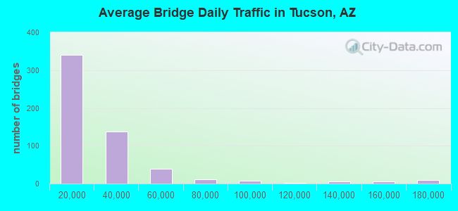
- 12,896,552Total average daily traffic
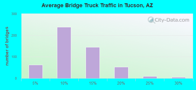
- 1,465,120Total average daily truck traffic
- National Bridge Inventory (NBI) Registered Bridges for Tucson
- No street view available for this location
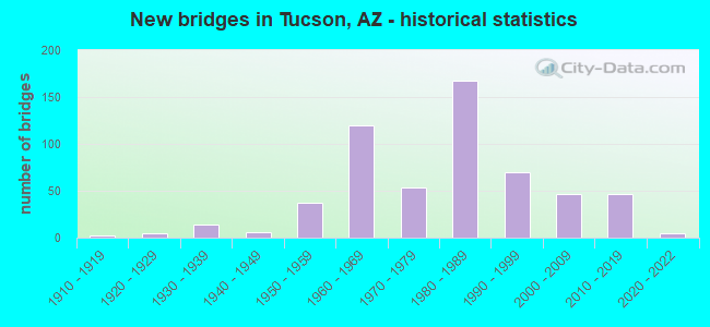
- New bridges - historical statistics
- 21910-1919
- 51920-1929
- 141930-1939
- 61940-1949
- 371950-1959
- 1201960-1969
- 541970-1979
- 1671980-1989
- 701990-1999
- 472000-2009
- 462010-2019
- 52020-2022
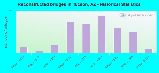
- Reconstructed bridges - Historical Statistics
- 31930-1939
- 11940-1949
- 41950-1959
- 151960-1969
- 141970-1979
- 181980-1989
- 121990-1999
- 102000-2009
- 22010-2019
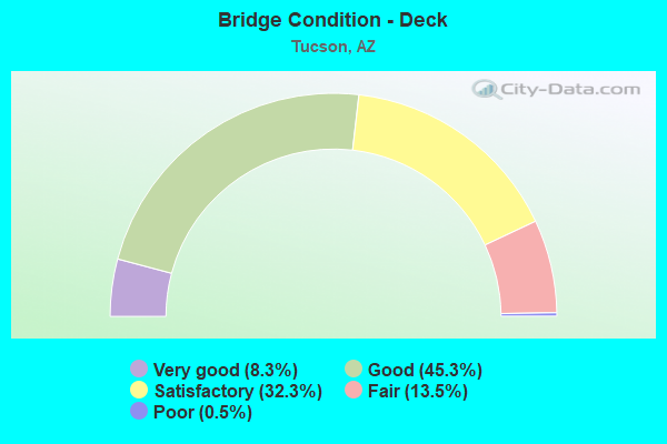
- Bridge Condition - Deck
- 8.3%Very good
- 45.3%Good
- 32.3%Satisfactory
- 13.5%Fair
- 0.5%Poor
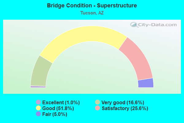
- Bridge Condition - Superstructure
- 1.0%Excellent
- 16.6%Very good
- 51.8%Good
- 25.6%Satisfactory
- 5.0%Fair
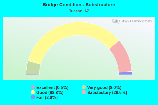
- Bridge Condition - Substructure
- 0.5%Excellent
- 8.0%Very good
- 68.8%Good
- 20.6%Satisfactory
- 2.0%Fair
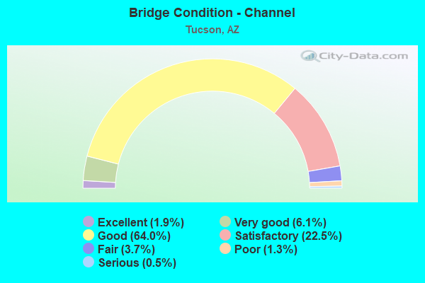
- Bridge Condition - Channel
- 1.9%Excellent
- 6.1%Very good
- 64.0%Good
- 22.5%Satisfactory
- 3.7%Fair
- 1.3%Poor
- 0.5%Serious
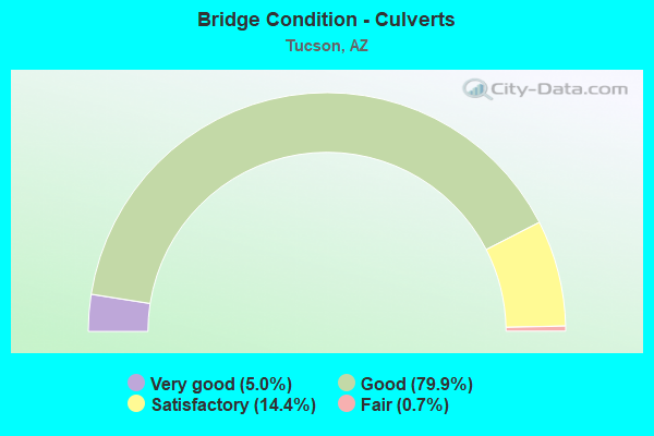
- Bridge Condition - Culverts
- 5.0%Very good
- 79.9%Good
- 14.4%Satisfactory
- 0.7%Fair
Find on map >> Show street view
Structure Number: 9938, Location: 0.13 mi E of Granada Ave (Lat: 32.221500, Lng: -110.973800), Route carried "under" structure: City street , Year Built: 1986, Structure Length: 0. m, Average Daily Traffic: 25,486 (year 2020), Truck Traffic: 10%, Features Intersected: Congress St, Facility Carried by Structure: Congress St Ped UP
Minimum Vertical Clearance: 4.96m (16.27ft), Kilometerpoint: 0.000, Lanes under structure: 5, Material/Design: Concrete continuous, Design/Construction: Box Beam or Girders - Single/Spread, Length of Maximum Span: 24.7m (81.0ft)
Find on map >> Show street view
Structure Number: 9944, Location: 0.08 mi E of jct I-10 (Lat: 32.250300, Lng: -110.991700), Route carried "under" structure: City street , Year Built: 1963, Structure Length: 0. m, Average Daily Traffic: 31,565 (year 2020), Truck Traffic: 10%, Features Intersected: Grant Road, Facility Carried by Structure: SPRR
Minimum Vertical Clearance: 4.43m (14.53ft), Kilometerpoint: 0.000, Material/Design: Steel, Design/Construction: Stringer/Multi-beam, Length of Maximum Span: 15.8m (51.8ft)
Find on map >> Show street view
Structure Number: 9945, Location: 0.16 mi E of I 10 (Lat: 32.235700, Lng: -110.981300), Route carried "under" structure: City street , Year Built: 1958, Structure Length: 0. m, Average Daily Traffic: 35,508 (year 2020), Truck Traffic: 10%, Features Intersected: Speedway Blvd, Facility Carried by Structure: Yuma Street
Minimum Vertical Clearance: 4.56m (14.96ft), Kilometerpoint: 0.000, Lanes on structure: 1, Lanes under structure: 4, Material/Design: Concrete continuous, Design/Construction: Slab, Length of Maximum Span: 12.5m (41.0ft)
Find on map >> Show street view
Structure Number: 9946, Location: 0.15 mi E of I 10 (Lat: 32.235700, Lng: -110.981800), Route carried "under" structure: City street , Year Built: 1958, Structure Length: 0. m, Average Daily Traffic: 35,508 (year 2020), Truck Traffic: 10%, Features Intersected: Speedway Blvd, Facility Carried by Structure: Van Alstine Drive
Minimum Vertical Clearance: 4.36m (14.30ft), Kilometerpoint: 0.000, Lanes on structure: 1, Lanes under structure: 2, Material/Design: Concrete continuous, Design/Construction: Slab, Length of Maximum Span: 12.2m (40.0ft)
Find on map >> Show street view
Structure Number: 9955, Location: 0.08 W of Church St (Lat: 32.222400, Lng: -110.973900), Route carried "under" structure: City street , Year Built: 1985, Structure Length: 0. m, Average Daily Traffic: 1,562 (year 2019), Truck Traffic: 5%, Features Intersected: Pennington Street, Facility Carried by Structure: Pedestrian X-ing
Minimum Vertical Clearance: 4.87m (15.98ft), Kilometerpoint: 0.000, Material/Design: Prestressed concrete, Design/Construction: Slab, Length of Maximum Span: 14.0m (45.9ft)
Find on map >> Show street view
Structure Number: 9956, Location: 500 ft W of Church St (Lat: 32.222400, Lng: -110.973500), Route carried "under" structure: City street , Year Built: 1985, Structure Length: 0. m, Average Daily Traffic: 1,562 (year 2020), Truck Traffic: 5%, Features Intersected: Pennington Street, Facility Carried by Structure: Pedestrian X-ing
Minimum Vertical Clearance: 4.65m (15.26ft), Kilometerpoint: 0.000, Material/Design: Prestressed concrete, Design/Construction: Box Beam or Girders - Multiple, Length of Maximum Span: 14.0m (45.9ft)
Find on map >> Show street view
Structure Number: 9974, Location: 0.3 mi S Jct 29th St (Lat: 32.194900, Lng: -110.910700), Route carried "under" structure: City street , Year Built: 1984, Structure Length: 0. m, Average Daily Traffic: 694 (year 2020), Truck Traffic: 5%, Features Intersected: 34-36 Connection, Facility Carried by Structure: Alvernon Way
Minimum Vertical Clearance: 4.97m (16.31ft), Kilometerpoint: 0.000, Lanes on structure: 2, Lanes under structure: 2, Material/Design: Prestressed concrete, Design/Construction: Box Beam or Girders - Single/Spread, Length of Maximum Span: 21.0m (68.9ft)
Find on map >> Show street view
Structure Number: 10008, Location: 1 mi E Jct Sabino Cyn Rd (Lat: 32.253300, Lng: -110.823800), Route carried "under" structure: City street , Year Built: 1985, Structure Length: 0. m, Average Daily Traffic: 27,078 (year 2018), Truck Traffic: 5%, Features Intersected: Pantano Rd, Facility Carried by Structure: Tanque Verde Road
Minimum Vertical Clearance: 5.69m (18.67ft), Kilometerpoint: 0.000, Lanes on structure: 2, Lanes under structure: 2, Material/Design: Prestressed concrete, Design/Construction: Box Beam or Girders - Single/Spread, Length of Maximum Span: 49.7m (163.1ft)
Find on map >> Show street view
Structure Number: 10437, Location: 0.11 mi W of Euclid Ave (Lat: 32.221200, Lng: -110.961300), Route carried "under" structure: City street , Year Built: 2000, Structure Length: 0. m, Average Daily Traffic: 26,194 (year 2020), Truck Traffic: 10%, Features Intersected: Broadway Blvd., Facility Carried by Structure: Cycle/Pedestr. OP
Minimum Vertical Clearance: 5.47m (17.95ft), Kilometerpoint: 0.000, Lanes under structure: 10, Material/Design: Prestressed concrete continuous, Design/Construction: Box Beam or Girders - Single/Spread, Length of Maximum Span: 42.7m (140.1ft)
Find on map >> Show street view
Structure Number: 10501, Location: Palo Verde Rd at UPRR (Lat: 32.190561, Lng: -110.915889), Route carried "under" structure: State highway 210, Year Built: 2012, Structure Length: 0. m, Average Daily Traffic: 15,658 (year 2020), Truck Traffic: 5%, Features Intersected: UPRR/36th St, Facility Carried by Structure: Palo Verde Rd
Minimum Vertical Clearance: 7.16m (23.49ft), Kilometerpoint: 7.612, Lanes on structure: 4, Lanes under structure: 7, Material/Design: Prestressed concrete continuous, Design/Construction: Stringer/Multi-beam, Length of Maximum Span: 23.5m (77.1ft)
Find on map >> Show street view
Structure Number: 11354, Location: 0.3 mi S Jct SR 210 (Lat: 32.206500, Lng: -110.949500), Route carried "under" structure: City street , Year Built: 2015, Structure Length: 0. m, Average Daily Traffic: 33,373 (year 2020), Truck Traffic: 10%, Features Intersected: 22nd Street, Facility Carried by Structure: Kino Parkway
Minimum Vertical Clearance: 5.43m (17.81ft), Kilometerpoint: 0.000, Lanes on structure: 2, Lanes under structure: 6, Material/Design: Prestressed concrete continuous, Design/Construction: Box Beam or Girders - Single/Spread, Length of Maximum Span: 54.6m (179.1ft)
Find on map >> Show street view
Structure Number: 11371, Location: 0.3 mi S Jct SR 210 (Lat: 32.206500, Lng: -110.949700), Route carried "under" structure: City street , Year Built: 2015, Structure Length: 0. m, Average Daily Traffic: 33,373 (year 2020), Truck Traffic: 10%, Features Intersected: 22nd Street, Facility Carried by Structure: Kino Parkway
Minimum Vertical Clearance: 5.43m (17.81ft), Kilometerpoint: 0.000, Lanes on structure: 2, Lanes under structure: 6, Material/Design: Prestressed concrete continuous, Design/Construction: Box Beam or Girders - Single/Spread, Length of Maximum Span: 54.6m (179.1ft)
Find on map >> Show street view
Structure Number: 11551, Location: Ruthrauff Rd (Lat: 32.294200, Lng: -111.026900), Route carried "under" structure: City street , Year Built: 2021, Structure Length: 0. m, Average Daily Traffic: 200 (year 2021), Truck Traffic: 5%, Features Intersected: Davis Avenue, Facility Carried by Structure: Ruthrauff Rd
Minimum Vertical Clearance: 0.00m, Kilometerpoint: 0.000, Lanes on structure: 5, Lanes under structure: 2, Material/Design: Concrete, Design/Construction: Frame, Length of Maximum Span: 12.8m (42.0ft)
Find on map >> Show street view
Structure Number: 20059, Location: 1.50 mi S Jct I-10 (Lat: 32.177800, Lng: -110.986000), Route carried "under" structure: Interstate 19, Year Built: 2017, Structure Length: 0. m, Average Daily Traffic: 91,729 (year 2018), Truck Traffic: 19%, Features Intersected: I-19, Facility Carried by Structure: Ajo Way
Minimum Vertical Clearance: 5.45m (17.88ft), Kilometerpoint: 99.618, Lanes on structure: 8, Lanes under structure: 8, Material/Design: Prestressed concrete continuous, Design/Construction: Stringer/Multi-beam, Length of Maximum Span: 33.2m (108.9ft)
Find on map >> Show street view
Structure Number: 20092, Location: I -19 MP 61.4 (Lat: 32.170900, Lng: -110.985500), Route carried "under" structure: Interstate 19, Year Built: 2019, Structure Length: 0. m, Average Daily Traffic: 91,729 (year 2020), Truck Traffic: 19%, Features Intersected: I-19, Facility Carried by Structure: Pedestrian Crossin
Minimum Vertical Clearance: 5.45m (17.88ft), Kilometerpoint: 98.814, Material/Design: Steel, Design/Construction: Truss - Thru, Length of Maximum Span: 44.2m (145.0ft)
Find on map >> Show street view
Structure Number: 20094, Location: 11.4 mi N Jct I-19 (Lat: 32.337600, Lng: -111.066900), Route carried "under" structure: Interstate 10, Year Built: 2018, Structure Length: 0. m, Average Daily Traffic: 84,665 (year 2018), Truck Traffic: 19%, Features Intersected: I-10, Facility Carried by Structure: Ina Rd
Minimum Vertical Clearance: 6.59m (21.62ft), Kilometerpoint: 400.276, Lanes on structure: 7, Lanes under structure: 6, Material/Design: Prestressed concrete, Design/Construction: Stringer/Multi-beam, Length of Maximum Span: 43.6m (143.0ft)
Find on map >> Show street view
Structure Number: 20159, Location: 7.8 mi N Jct I-19 (Lat: 32.294200, Lng: -111.029700), Route carried "under" structure: Interstate 10, Year Built: 2019, Structure Length: 0. m, Average Daily Traffic: 111,062 (year 2020), Truck Traffic: 13%, Features Intersected: I-10, Facility Carried by Structure: Ruthrauff Rd
Minimum Vertical Clearance: 5.38m (17.65ft), Kilometerpoint: 405.555, Lanes on structure: 8, Lanes under structure: 8, Material/Design: Prestressed concrete, Design/Construction: Stringer/Multi-beam, Length of Maximum Span: 42.4m (139.1ft)
Find on map >> Show street view
Structure Number: 20173, Location: 15.1 mi E Jct I 19 (Lat: 32.061800, Lng: -110.773500), Route carried "under" structure: Interstate 10, Year Built: 2021, Structure Length: 0. m, Average Daily Traffic: 37,380 (year 2020), Truck Traffic: 20%, Features Intersected: I-10, Facility Carried by Structure: Houghton Rd
Minimum Vertical Clearance: 5.55m (18.21ft), Kilometerpoint: 443.310, Lanes on structure: 7, Lanes under structure: 4, Material/Design: Prestressed concrete, Design/Construction: Stringer/Multi-beam, Length of Maximum Span: 36.6m (120.1ft)