Bridge Statistics for Tucson, Arizona (AZ)
Condition, Traffic, Stress, Structural Evaluation, Project Costs
- National Bridge Inventory (NBI) Statistics
- 573Number of bridges
- 5,620ft / 1,713mTotal length
- $151,000Total costs
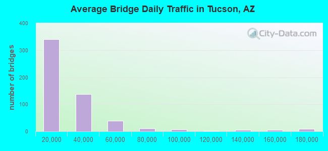
- 12,896,552Total average daily traffic
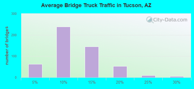
- 1,465,120Total average daily truck traffic
- National Bridge Inventory (NBI) Registered Bridges for Tucson
- No street view available for this location
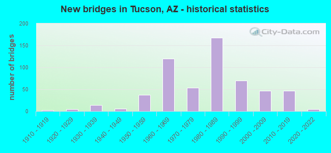
- New bridges - historical statistics
- 21910-1919
- 51920-1929
- 141930-1939
- 61940-1949
- 371950-1959
- 1201960-1969
- 541970-1979
- 1671980-1989
- 701990-1999
- 472000-2009
- 462010-2019
- 52020-2022
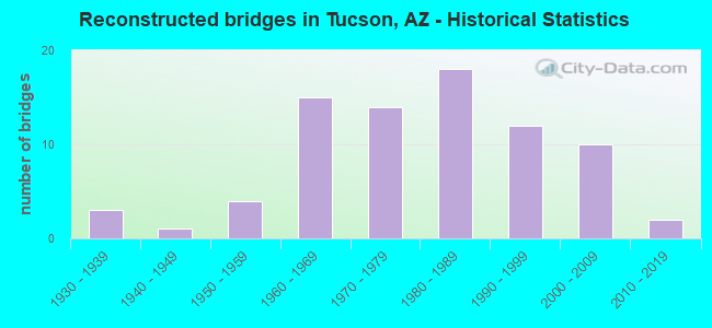
- Reconstructed bridges - Historical Statistics
- 31930-1939
- 11940-1949
- 41950-1959
- 151960-1969
- 141970-1979
- 181980-1989
- 121990-1999
- 102000-2009
- 22010-2019
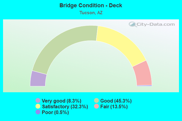
- Bridge Condition - Deck
- 8.3%Very good
- 45.3%Good
- 32.3%Satisfactory
- 13.5%Fair
- 0.5%Poor
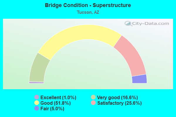
- Bridge Condition - Superstructure
- 1.0%Excellent
- 16.6%Very good
- 51.8%Good
- 25.6%Satisfactory
- 5.0%Fair
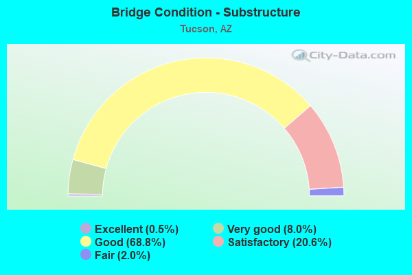
- Bridge Condition - Substructure
- 0.5%Excellent
- 8.0%Very good
- 68.8%Good
- 20.6%Satisfactory
- 2.0%Fair
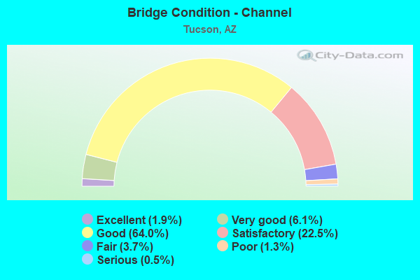
- Bridge Condition - Channel
- 1.9%Excellent
- 6.1%Very good
- 64.0%Good
- 22.5%Satisfactory
- 3.7%Fair
- 1.3%Poor
- 0.5%Serious
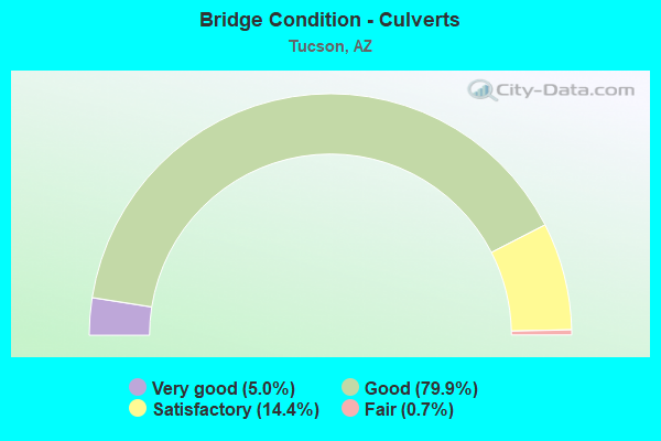
- Bridge Condition - Culverts
- 5.0%Very good
- 79.9%Good
- 14.4%Satisfactory
- 0.7%Fair
Find on map >> Show street view
Structure Number: 9879, Location: 200 ft S of 15th Street (Lat: 32.214500, Lng: -110.946700), Route carried "on" structure: City street , Year Built: 1987, Status: Open, Structure Length: 1.86m (6.10ft), Average Daily Traffic: 23,351 (year 2020), Truck Traffic: 10%, Average Future Daily Traffic: 23,361 (year 2040), Design Load: HS 20, Features Intersected: Railroad Wash, Facility Carried by Structure: Kino Blvd
Minimum Vertical Clearance: 30+ m (98+ ft), Kilometerpoint: 0.000, Lanes on structure: 6, Owner: City or Municipal Highway Agency, Approaching Roadway Width: 29.3m (96.1ft), Skew: 23 degrees, Material/Design: Concrete continuous, Design/Construction: Culvert, Number Of Spans In Main Unit: 4, Length of Maximum Span: 4.3m (14.1ft), Curb or Sidewalk Widths: Left: 1.5m (4.9ft), Right: 1.5m (4.9ft)
Condition: Channel: Satisfactory, Culverts: Good, Operating Rating: 89.8 metric tons, Method Used To Determine Operating Rating: Load Factor (LF), Inventory Rating: 89.8 metric tons, Method Used To Determine Inventory Rating: Load Factor (LF), Structural Evaluation: Better than present minimum criteria, Waterway Adequacy: Better than present minimum criteria, Approach Roadway Alignment: Equal to present desirable criteria, Designated Inspection Frequency: Every 48 months, Inspection Date: August 2021
Find on map >> Show street view
Structure Number: 9921, Location: 200 ft N of 15th Street (Lat: 32.216100, Lng: -110.945400), Route carried "on" structure: City street , Year Built: 1987, Status: Open, Structure Length: 3.26m (10.70ft), Average Daily Traffic: 28,056 (year 2020), Truck Traffic: 10%, Average Future Daily Traffic: 28,066 (year 2040), Design Load: HS 20, Features Intersected: Tucson Arroyo, Facility Carried by Structure: Kino Blvd
Minimum Vertical Clearance: 30+ m (98+ ft), Kilometerpoint: 0.000, Lanes on structure: 6, Owner: City or Municipal Highway Agency, Approaching Roadway Width: 29.3m (96.1ft), Skew: 26 degrees, Material/Design: Concrete continuous, Design/Construction: Culvert, Number Of Spans In Main Unit: 5, Length of Maximum Span: 6.1m (20.0ft), Curb or Sidewalk Widths: Left: 1.5m (4.9ft), Right: 1.5m (4.9ft)
Condition: Channel: Good, Culverts: Satisfactory, Operating Rating: 61.7 metric tons, Method Used To Determine Operating Rating: Load Factor (LF), Inventory Rating: 37.2 metric tons, Method Used To Determine Inventory Rating: Load Factor (LF), Structural Evaluation: Equal to present minimum criteria, Waterway Adequacy: Better than present minimum criteria, Approach Roadway Alignment: Equal to present desirable criteria, Designated Inspection Frequency: Every 48 months, Inspection Date: August 2021
Find on map >> Show street view
Structure Number: 993, Location: 0.25 mi S of River Rd (Lat: 32.271672, Lng: -110.892514), Route carried "on" structure: County highway , Year Built: 1985, Year Reconstructed: 1998, Status: Posted for load, Structure Length: 14.72m (48.29ft), Average Daily Traffic: 20,000 (year 2012), Average Future Daily Traffic: 31,000 (year 2030), Design Load: HS 20, Features Intersected: Rillito River, Facility Carried by Structure: Swan Road
Minimum Vertical Clearance: 30+ m (98+ ft), Kilometerpoint: 0.000, Lanes on structure: 4, Owner: County Highway Agency, Approaching Roadway Width: 32.6m (107.0ft), Skew: 22 degrees, Material/Design: Prestressed concrete, Design/Construction: Stringer/Multi-beam, Number Of Spans In Main Unit: 5, Length of Maximum Span: 29.6m (97.1ft), Curb or Sidewalk Widths: Left: 1.5m (4.9ft), Right: 1.5m (4.9ft), Curb-To-Curb Width: 28.0m (91.9ft), Out-to-Out Width: 32.6m (107.0ft)
Condition: Deck: Satisfactory, Superstructure: Good, Substructure: Good, Channel: Good, Inventory Rating: 43.5 metric tons, Method Used To Determine Inventory Rating: Load Factor (LF), Structural Evaluation: Better than present minimum criteria, Deck Geometry: Superior to present desirable criteria, Waterway Adequacy: Equal to present desirable criteria, Approach Roadway Alignment: Equal to present desirable criteria, Designated Inspection Frequency: Every 24 months, Inspection Date: December 2020, Deck Structure Type: Concrete Cast-file-Place, Wearing Surface/Protective System: Wearing Surface: Monolithic Concrete
Find on map >> Show street view
Structure Number: 9931, Location: 0.5 mi E Jct Pantano Rd (Lat: 32.191900, Lng: -110.815000), Route carried "on" structure: City street , Year Built: 1980, Status: Open, Structure Length: 2.35m (7.71ft), Average Daily Traffic: 25,845 (year 2020), Truck Traffic: 10%, Average Future Daily Traffic: 25,855 (year 2040), Design Load: HS 20, Features Intersected: Atterbury Wash, Facility Carried by Structure: Golf Links Rd
Minimum Vertical Clearance: 30+ m (98+ ft), Kilometerpoint: 0.000, Lanes on structure: 7, Owner: City or Municipal Highway Agency, Approaching Roadway Width: 15.8m (51.8ft), Skew: 30 degrees, Material/Design: Concrete continuous, Design/Construction: Culvert, Number Of Spans In Main Unit: 6, Length of Maximum Span: 3.7m (12.1ft), Curb or Sidewalk Widths: Left: 2.7m (8.9ft), Right: 2.7m (8.9ft), Curb-To-Curb Width: 28.7m (94.2ft), Out-to-Out Width: 36.7m (120.4ft)
Condition: Channel: Good, Culverts: Good, Operating Rating: 54.4 metric tons, Method Used To Determine Operating Rating: Load Factor (LF), Inventory Rating: 32.7 metric tons, Method Used To Determine Inventory Rating: Load Factor (LF), Structural Evaluation: Better than present minimum criteria, Deck Geometry: Somewhat better than minimum adequacy, Waterway Adequacy: Better than present minimum criteria, Approach Roadway Alignment: Equal to present desirable criteria, Designated Inspection Frequency: Every 48 months, Inspection Date: October 2021, Deck Structure Type: Concrete Cast-file-Place, Wearing Surface/Protective System: Wearing Surface: Bituminous
Find on map >> Show street view
Structure Number: 9932, Location: 0.25 mi W of Jct I 19 (Lat: 32.163200, Lng: -110.990200), Route carried "on" structure: City street , Year Built: 1960, Year Reconstructed: 1985, Status: Open, Structure Length: 1.74m (5.71ft), Average Daily Traffic: 20,552 (year 2020), Truck Traffic: 5%, Average Future Daily Traffic: 20,562 (year 2040), Design Load: HS 20, Features Intersected: Wash, Facility Carried by Structure: Irvington Road
Minimum Vertical Clearance: 30+ m (98+ ft), Kilometerpoint: 0.000, Lanes on structure: 4, Owner: City or Municipal Highway Agency, Approaching Roadway Width: 21.6m (70.9ft), Skew: 3 degrees, Material/Design: Concrete continuous, Design/Construction: Culvert, Number Of Spans In Main Unit: 3, Length of Maximum Span: 3.0m (9.8ft), Curb or Sidewalk Widths: Left: 2.4m (7.9ft), Right: 1.2m (3.9ft)
Condition: Channel: Good, Culverts: Satisfactory, Operating Rating: 89.8 metric tons, Method Used To Determine Operating Rating: Load Factor (LF), Inventory Rating: 71.7 metric tons, Method Used To Determine Inventory Rating: Load Factor (LF), Structural Evaluation: Equal to present minimum criteria, Waterway Adequacy: Better than present minimum criteria, Approach Roadway Alignment: Equal to present desirable criteria, Length Of Structure Improvement: 2.50m (8.20ft), Designated Inspection Frequency: Every 48 months, Inspection Date: May 2021, Total Project Cost: $2,000 ( Estimate for 2017)
Find on map >> Show street view
Structure Number: 9933, Location: 0.2 mi S Jct 22nd St (Lat: 32.203300, Lng: -110.995400), Route carried "on" structure: City street , Year Built: 1987, Status: Open, Structure Length: 0.64m (2.10ft), Average Daily Traffic: 18,916 (year 2018), Truck Traffic: 5%, Average Future Daily Traffic: 18,926 (year 2039), Design Load: HS 20, Features Intersected: Wash, Facility Carried by Structure: Mission Road
Minimum Vertical Clearance: 30+ m (98+ ft), Kilometerpoint: 0.000, Lanes on structure: 7, Owner: City or Municipal Highway Agency, Approaching Roadway Width: 30.5m (100.1ft), Skew: 20 degrees, Material/Design: Concrete continuous, Design/Construction: Culvert, Number Of Spans In Main Unit: 2, Length of Maximum Span: 3.0m (9.8ft), Curb or Sidewalk Widths: Left: 1.2m (3.9ft), Right: 1.2m (3.9ft)
Condition: Channel: Good, Culverts: Good, Operating Rating: 64.4 metric tons, Method Used To Determine Operating Rating: Load Factor (LF), Inventory Rating: 38.1 metric tons, Method Used To Determine Inventory Rating: Load Factor (LF), Structural Evaluation: Better than present minimum criteria, Waterway Adequacy: Equal to present desirable criteria, Approach Roadway Alignment: Equal to present desirable criteria, Designated Inspection Frequency: Every 48 months, Inspection Date: April 2019
Find on map >> Show street view
Structure Number: 9934, Location: 0.2 mi S Jct Drexel Rd (Lat: 32.146092, Lng: -110.934864), Route carried "on" structure: City street , Year Built: 1986, Status: Open, Structure Length: 0.91m (2.99ft), Average Daily Traffic: 17,930 (year 2017), Truck Traffic: 5%, Average Future Daily Traffic: 17,940 (year 2039), Design Load: HS 20, Features Intersected: Rodeo Wash, Facility Carried by Structure: Tucson Blvd
Minimum Vertical Clearance: 30+ m (98+ ft), Kilometerpoint: 0.000, Lanes on structure: 4, Owner: City or Municipal Highway Agency, Approaching Roadway Width: 17.1m (56.1ft), Skew: 24 degrees, Material/Design: Concrete continuous, Design/Construction: Culvert, Number Of Spans In Main Unit: 2, Length of Maximum Span: 3.0m (9.8ft), Curb or Sidewalk Widths: Left: 2.2m (7.2ft), Right: 2.3m (7.5ft), Curb-To-Curb Width: 23.3m (76.4ft), Out-to-Out Width: 28.7m (94.2ft)
Condition: Channel: Satisfactory, Culverts: Good, Operating Rating: 55.3 metric tons, Method Used To Determine Operating Rating: Load Factor (LF), Inventory Rating: 32.7 metric tons, Method Used To Determine Inventory Rating: Load Factor (LF), Structural Evaluation: Better than present minimum criteria, Deck Geometry: Superior to present desirable criteria, Waterway Adequacy: Equal to present desirable criteria, Approach Roadway Alignment: Equal to present desirable criteria, Designated Inspection Frequency: Every 48 months, Inspection Date: April 2019, Deck Structure Type: Concrete Cast-file-Place, Wearing Surface/Protective System: Wearing Surface: Bituminous
Find on map >> Show street view
Structure Number: 9935, Location: 0.2 mi N Jct Drexel Rd (Lat: 32.151500, Lng: -110.935000), Route carried "on" structure: City street , Year Built: 1986, Status: Open, Structure Length: 1.10m (3.61ft), Average Daily Traffic: 17,930 (year 2017), Truck Traffic: 5%, Average Future Daily Traffic: 17,940 (year 2039), Design Load: HS 20, Features Intersected: Wash, Facility Carried by Structure: Tucson Blvd
Minimum Vertical Clearance: 30+ m (98+ ft), Kilometerpoint: 0.000, Lanes on structure: 5, Owner: City or Municipal Highway Agency, Approaching Roadway Width: 23.2m (76.1ft), Skew: 23 degrees, Material/Design: Concrete continuous, Design/Construction: Culvert, Number Of Spans In Main Unit: 3, Length of Maximum Span: 3.0m (9.8ft), Curb or Sidewalk Widths: Left: 2.3m (7.5ft), Right: 3.5m (11.5ft), Curb-To-Curb Width: 23.2m (76.1ft), Out-to-Out Width: 28.6m (93.8ft)
Condition: Channel: Good, Culverts: Good, Operating Rating: 53.5 metric tons, Method Used To Determine Operating Rating: Load Factor (LF), Inventory Rating: 31.8 metric tons, Method Used To Determine Inventory Rating: Load Factor (LF), Structural Evaluation: Better than present minimum criteria, Deck Geometry: Better than present minimum criteria, Waterway Adequacy: Equal to present desirable criteria, Approach Roadway Alignment: Equal to present desirable criteria, Designated Inspection Frequency: Every 48 months, Inspection Date: April 2019, Deck Structure Type: Concrete Cast-file-Place, Wearing Surface/Protective System: Wearing Surface: Bituminous
Find on map >> Show street view
Structure Number: 9938, Location: 0.13 mi E of Granada Ave (Lat: 32.221500, Lng: -110.973800), Route carried "on" structure: _, Year Built: 1986, Status: Open, Structure Length: 6.37m (20.90ft), Design Load: Pedestrian, Features Intersected: Congress St, Facility Carried by Structure: Congress St Ped UP
Kilometerpoint: 0.000, Lanes under structure: 5, Owner: City or Municipal Highway Agency, Material/Design: Concrete continuous, Design/Construction: Box Beam or Girders - Single/Spread, Number Of Spans In Main Unit: 2, Number Of Approach Spans: 2, Length of Maximum Span: 24.7m (81.0ft), Out-to-Out Width: 6.7m (22.0ft)
Condition: Deck: Good, Superstructure: Good, Substructure: Good, Structural Evaluation: Better than present minimum criteria, Underclear: Equal to present minimum criteria, Designated Inspection Frequency: Every 24 months, Inspection Date: July 2021, Deck Structure Type: Concrete Cast-file-Place, Wearing Surface/Protective System: Wearing Surface: Other
Find on map >> Show street view
Structure Number: 9942, Location: 0.4 mi W of Silverbell Rd (Lat: 32.250700, Lng: -111.020800), Route carried "on" structure: City street , Year Built: 1986, Status: Open, Structure Length: 4.18m (13.71ft), Average Daily Traffic: 14,533 (year 2020), Truck Traffic: 10%, Average Future Daily Traffic: 14,543 (year 2040), Design Load: HS 20, Features Intersected: Wash, Facility Carried by Structure: Ironwood Hill Dr
Minimum Vertical Clearance: 30+ m (98+ ft), Kilometerpoint: 0.000, Lanes on structure: 3, Owner: City or Municipal Highway Agency, Approaching Roadway Width: 13.4m (44.0ft), Skew: 24 degrees, Material/Design: Concrete continuous, Design/Construction: Culvert, Number Of Spans In Main Unit: 9, Length of Maximum Span: 4.3m (14.1ft)
Condition: Channel: Good, Culverts: Good, Operating Rating: 89.8 metric tons, Method Used To Determine Operating Rating: Load Factor (LF), Inventory Rating: 74.4 metric tons, Method Used To Determine Inventory Rating: Load Factor (LF), Structural Evaluation: Better than present minimum criteria, Waterway Adequacy: Better than present minimum criteria, Approach Roadway Alignment: Equal to present desirable criteria, Length Of Structure Improvement: 4.45m (14.60ft), Designated Inspection Frequency: Every 48 months, Inspection Date: August 2021, Total Project Cost: $1,000
Find on map >> Show street view
Structure Number: 9943, Location: 0.31 mi N of Grant Rd (Lat: 32.255300, Lng: -111.016300), Route carried "on" structure: City street , Year Built: 1987, Year Reconstructed: 2015, Status: Open, Structure Length: 1.95m (6.40ft), Average Daily Traffic: 10,053 (year 2020), Truck Traffic: 10%, Average Future Daily Traffic: 10,063 (year 2040), Design Load: HS 20, Features Intersected: Wash, Facility Carried by Structure: Silverbell Road
Minimum Vertical Clearance: 30+ m (98+ ft), Kilometerpoint: 0.000, Lanes on structure: 4, Owner: City or Municipal Highway Agency, Approaching Roadway Width: 13.4m (44.0ft), Skew: 20 degrees, Material/Design: Concrete continuous, Design/Construction: Culvert, Number Of Spans In Main Unit: 5, Length of Maximum Span: 3.7m (12.1ft)
Condition: Channel: Satisfactory, Culverts: Good, Operating Rating: 64.4 metric tons, Method Used To Determine Operating Rating: Load Factor (LF), Inventory Rating: 38.1 metric tons, Method Used To Determine Inventory Rating: Load Factor (LF), Structural Evaluation: Better than present minimum criteria, Waterway Adequacy: Better than present minimum criteria, Approach Roadway Alignment: Equal to present desirable criteria, Length Of Structure Improvement: 2.74m (8.99ft), Designated Inspection Frequency: Every 48 months, Inspection Date: August 2021, Total Project Cost: $1,000
Find on map >> Show street view
Structure Number: 9944, Location: 0.08 mi E of jct I-10 (Lat: 32.250300, Lng: -110.991700), Route carried "on" structure: _, Year Built: 1963, Status: Open, Structure Length: 3.57m (11.71ft), Design Load: Railroad, Features Intersected: Grant Road, Facility Carried by Structure: SPRR
Kilometerpoint: 0.000, Lanes under structure: 4, Owner: City or Municipal Highway Agency, Skew: 3 degrees, Material/Design: Steel, Design/Construction: Stringer/Multi-beam, Number Of Spans In Main Unit: 2, Length of Maximum Span: 15.8m (51.8ft), Out-to-Out Width: 14.6m (47.9ft)
Condition: Superstructure: Fair, Substructure: Good, Operating Rating: 65.3 metric tons, Method Used To Determine Operating Rating: No rating analysis performed, Inventory Rating: 65.3 metric tons, Method Used To Determine Inventory Rating: No rating analysis performed, Structural Evaluation: Somewhat better than minimum adequacy, Underclear: High priority of corrective action, Designated Inspection Frequency: Every 24 months, Inspection Date: July 2021, Deck Structure Type: Concrete Cast-file-Place, Wearing Surface/Protective System: Wearing Surface: Gravel
Find on map >> Show street view
Structure Number: 9945, Location: 0.16 mi E of I 10 (Lat: 32.235700, Lng: -110.981300), Route carried "on" structure: City street , Year Built: 1958, Status: Open, Structure Length: 2.53m (8.30ft), Average Daily Traffic: 300 (year 2021), Truck Traffic: 5%, Average Future Daily Traffic: 310 (year 2041), Design Load: HS 20, Features Intersected: Speedway Blvd, Facility Carried by Structure: Yuma Street
Minimum Vertical Clearance: 30+ m (98+ ft), Kilometerpoint: 0.000, Lanes on structure: 1, Lanes under structure: 4, Owner: City or Municipal Highway Agency, Approaching Roadway Width: 7.9m (25.9ft), Material/Design: Concrete continuous, Design/Construction: Slab, Number Of Spans In Main Unit: 2, Length of Maximum Span: 12.5m (41.0ft), Curb or Sidewalk Widths: Left: 0.5m (1.6ft), Right: 0.5m (1.6ft), Curb-To-Curb Width: 7.9m (25.9ft), Out-to-Out Width: 9.4m (30.8ft)
Condition: Deck: Satisfactory, Superstructure: Satisfactory, Substructure: Satisfactory, Operating Rating: 59.0 metric tons, Method Used To Determine Operating Rating: Load Factor (LF), Inventory Rating: 35.4 metric tons, Method Used To Determine Inventory Rating: Load Factor (LF), Structural Evaluation: Equal to present minimum criteria, Deck Geometry: Somewhat better than minimum adequacy, Underclear: High priority of corrective action, Approach Roadway Alignment: Better than present minimum criteria, Designated Inspection Frequency: Every 24 months, Inspection Date: July 2021, Deck Structure Type: Concrete Cast-file-Place, Wearing Surface/Protective System: Wearing Surface: Monolithic Concrete
Find on map >> Show street view
Structure Number: 9946, Location: 0.15 mi E of I 10 (Lat: 32.235700, Lng: -110.981800), Route carried "on" structure: City street , Year Built: 1958, Status: Open, Structure Length: 2.53m (8.30ft), Average Daily Traffic: 500 (year 2021), Truck Traffic: 5%, Average Future Daily Traffic: 510 (year 2041), Design Load: HS 20, Features Intersected: Speedway Blvd, Facility Carried by Structure: Van Alstine Drive
Minimum Vertical Clearance: 30+ m (98+ ft), Kilometerpoint: 0.000, Lanes on structure: 1, Lanes under structure: 4, Owner: City or Municipal Highway Agency, Approaching Roadway Width: 7.9m (25.9ft), Material/Design: Concrete continuous, Design/Construction: Slab, Number Of Spans In Main Unit: 2, Length of Maximum Span: 12.2m (40.0ft), Curb or Sidewalk Widths: Left: 0.5m (1.6ft), Right: 0.5m (1.6ft), Curb-To-Curb Width: 7.9m (25.9ft), Out-to-Out Width: 9.4m (30.8ft)
Condition: Deck: Satisfactory, Superstructure: Satisfactory, Substructure: Satisfactory, Operating Rating: 59.0 metric tons, Method Used To Determine Operating Rating: Load Factor (LF), Inventory Rating: 35.4 metric tons, Method Used To Determine Inventory Rating: Load Factor (LF), Structural Evaluation: Equal to present minimum criteria, Deck Geometry: Somewhat better than minimum adequacy, Underclear: High priority of corrective action, Approach Roadway Alignment: Equal to present minimum criteria, Designated Inspection Frequency: Every 24 months, Inspection Date: July 2021, Deck Structure Type: Concrete Cast-file-Place, Wearing Surface/Protective System: Wearing Surface: Monolithic Concrete
Find on map >> Show street view
Structure Number: 9947, Location: 0.5 mi E Jct Swan Rd (Lat: 32.257900, Lng: -110.883900), Route carried "on" structure: City street , Year Built: 1986, Status: Open, Structure Length: 3.02m (9.91ft), Average Daily Traffic: 5,940 (year 2015), Truck Traffic: 5%, Average Future Daily Traffic: 5,950 (year 2039), Design Load: HS 20, Features Intersected: Arcadia Wash, Facility Carried by Structure: Glenn St
Minimum Vertical Clearance: 30+ m (98+ ft), Kilometerpoint: 0.000, Lanes on structure: 2, Owner: City or Municipal Highway Agency, Approaching Roadway Width: 13.4m (44.0ft), Skew: 3 degrees, Material/Design: Prestressed concrete, Design/Construction: Stringer/Multi-beam, Number Of Spans In Main Unit: 1, Length of Maximum Span: 29.0m (95.1ft), Curb or Sidewalk Widths: Left: 2.4m (7.9ft), Right: 2.4m (7.9ft), Curb-To-Curb Width: 13.4m (44.0ft), Out-to-Out Width: 18.4m (60.4ft)
Condition: Deck: Good, Superstructure: Good, Substructure: Good, Channel: Good, Operating Rating: 89.8 metric tons, Method Used To Determine Operating Rating: Load Factor (LF), Inventory Rating: 47.2 metric tons, Method Used To Determine Inventory Rating: Load Factor (LF), Structural Evaluation: Better than present minimum criteria, Deck Geometry: Equal to present minimum criteria, Waterway Adequacy: Equal to present desirable criteria, Approach Roadway Alignment: Equal to present desirable criteria, Designated Inspection Frequency: Every 24 months, Inspection Date: March 2021, Deck Structure Type: Concrete Cast-file-Place, Wearing Surface/Protective System: Wearing Surface: Monolithic Concrete
Find on map >> Show street view
Structure Number: 9948, Location: 0.1 mi N Jct 29th St (Lat: 32.201400, Lng: -110.892400), Route carried "on" structure: City street , Year Built: 1958, Year Reconstructed: 1971, Status: Open, Structure Length: 1.13m (3.71ft), Average Daily Traffic: 25,186 (year 2013), Truck Traffic: 10%, Average Future Daily Traffic: 25,196 (year 2039), Design Load: HS 20, Features Intersected: Wash, Facility Carried by Structure: Swan Road
Minimum Vertical Clearance: 5.49m (18.01ft), Kilometerpoint: 0.000, Lanes on structure: 4, Owner: City or Municipal Highway Agency, Approaching Roadway Width: 22.9m (75.1ft), Skew: 4 degrees, Material/Design: Concrete continuous, Design/Construction: Culvert, Number Of Spans In Main Unit: 3, Length of Maximum Span: 2.4m (7.9ft), Curb or Sidewalk Widths: Left: 1.2m (3.9ft), Right: 1.2m (3.9ft)
Condition: Channel: Good, Culverts: Good, Operating Rating: 89.8 metric tons, Method Used To Determine Operating Rating: Load Factor (LF), Inventory Rating: 89.8 metric tons, Method Used To Determine Inventory Rating: Load Factor (LF), Structural Evaluation: Better than present minimum criteria, Waterway Adequacy: Better than present minimum criteria, Approach Roadway Alignment: Equal to present desirable criteria, Designated Inspection Frequency: Every 48 months, Inspection Date: March 2019
Find on map >> Show street view
Structure Number: 9951, Location: 0.4 mi S Jct Silvrlake Rd (Lat: 32.194306, Lng: -110.998222), Route carried "on" structure: City street , Year Built: 1985, Status: Open, Structure Length: 0.64m (2.10ft), Average Daily Traffic: 24,352 (year 2018), Truck Traffic: 5%, Average Future Daily Traffic: 22,362 (year 2039), Design Load: HS 20, Features Intersected: Wash, Facility Carried by Structure: Mission Road
Minimum Vertical Clearance: 30+ m (98+ ft), Kilometerpoint: 0.000, Lanes on structure: 6, Owner: City or Municipal Highway Agency, Approaching Roadway Width: 31.1m (102.0ft), Skew: 20 degrees, Material/Design: Concrete continuous, Design/Construction: Culvert, Number Of Spans In Main Unit: 2, Length of Maximum Span: 3.0m (9.8ft)
Condition: Channel: Good, Culverts: Good, Operating Rating: 53.5 metric tons, Method Used To Determine Operating Rating: Load Factor (LF), Inventory Rating: 31.8 metric tons, Method Used To Determine Inventory Rating: Load Factor (LF), Structural Evaluation: Better than present minimum criteria, Waterway Adequacy: Equal to present desirable criteria, Approach Roadway Alignment: Equal to present desirable criteria, Designated Inspection Frequency: Every 48 months, Inspection Date: April 2019, Deck Structure Type: Concrete Cast-file-Place, Wearing Surface/Protective System: Wearing Surface: Bituminous
Find on map >> Show street view
Structure Number: 9955, Location: 0.08 W of Church St (Lat: 32.222400, Lng: -110.973900), Route carried "on" structure: _, Year Built: 1985, Status: Open, Structure Length: 1.58m (5.18ft), Design Load: Pedestrian, Features Intersected: Pennington Street, Facility Carried by Structure: Pedestrian X-ing
Kilometerpoint: 0.000, Lanes under structure: 1, Owner: City or Municipal Highway Agency, Material/Design: Prestressed concrete, Design/Construction: Slab, Number Of Spans In Main Unit: 1, Number Of Approach Spans: 1, Length of Maximum Span: 14.0m (45.9ft), Out-to-Out Width: 8.5m (27.9ft)
Condition: Deck: Satisfactory, Superstructure: Good, Substructure: Good, Structural Evaluation: Better than present minimum criteria, Underclear: Meets minimum limits, Designated Inspection Frequency: Every 24 months, Inspection Date: July 2021, Deck Structure Type: Concrete Cast-file-Place, Wearing Surface/Protective System: Wearing Surface: Other
Find on map >> Show street view
Structure Number: 997, Location: 0.3 mi E Jct Pantano Rd (Lat: 32.256000, Lng: -110.820900), Route carried "on" structure: City street , Year Built: 1987, Status: Open, Structure Length: 11.83m (38.81ft), Average Daily Traffic: 30,496 (year 2020), Truck Traffic: 5%, Average Future Daily Traffic: 30,506 (year 2040), Design Load: HS 20, Features Intersected: Tanque Verde Creek, Facility Carried by Structure: Tanque Verde Road
Minimum Vertical Clearance: 30+ m (98+ ft), Kilometerpoint: 0.000, Lanes on structure: 6, Owner: City or Municipal Highway Agency, Approaching Roadway Width: 34.1m (111.9ft), Skew: 20 degrees, Material/Design: Prestressed concrete continuous, Design/Construction: Stringer/Multi-beam, Number Of Spans In Main Unit: 4, Length of Maximum Span: 29.3m (96.1ft), Curb or Sidewalk Widths: Left: 1.5m (4.9ft), Right: 1.5m (4.9ft), Curb-To-Curb Width: 34.1m (111.9ft), Out-to-Out Width: 38.6m (126.6ft)
Condition: Deck: Satisfactory, Superstructure: Good, Substructure: Good, Channel: Good, Operating Rating: 58.1 metric tons, Method Used To Determine Operating Rating: Load Factor (LF), Inventory Rating: 32.7 metric tons, Method Used To Determine Inventory Rating: Load Factor (LF), Structural Evaluation: Better than present minimum criteria, Deck Geometry: Superior to present desirable criteria, Waterway Adequacy: Equal to present desirable criteria, Approach Roadway Alignment: Equal to present desirable criteria, Designated Inspection Frequency: Every 24 months, Inspection Date: October 2021, Deck Structure Type: Concrete Cast-file-Place, Wearing Surface/Protective System: Wearing Surface: Monolithic Concrete
Find on map >> Show street view
Structure Number: 9974, Location: 0.3 mi S Jct 29th St (Lat: 32.194900, Lng: -110.910700), Route carried "on" structure: City street , Year Built: 1984, Status: Open, Structure Length: 2.26m (7.41ft), Average Daily Traffic: 14,144 (year 2020), Truck Traffic: 5%, Average Future Daily Traffic: 14,154 (year 2040), Design Load: HS 20, Features Intersected: 34-36 Connection, Facility Carried by Structure: Alvernon Way
Minimum Vertical Clearance: 30+ m (98+ ft), Kilometerpoint: 0.000, Lanes on structure: 2, Lanes under structure: 2, Owner: City or Municipal Highway Agency, Approaching Roadway Width: 8.5m (27.9ft), Skew: 1 degrees, Material/Design: Prestressed concrete, Design/Construction: Box Beam or Girders - Single/Spread, Number Of Spans In Main Unit: 1, Length of Maximum Span: 21.0m (68.9ft), Curb-To-Curb Width: 8.5m (27.9ft), Out-to-Out Width: 9.5m (31.2ft)
Condition: Deck: Good, Superstructure: Good, Substructure: Good, Operating Rating: 54.4 metric tons, Method Used To Determine Operating Rating: Field evaluation and documented engineering judgment, Inventory Rating: 32.7 metric tons, Method Used To Determine Inventory Rating: Field evaluation and documented engineering judgment, Structural Evaluation: Better than present minimum criteria, Deck Geometry: High priority of corrective action, Underclear: High priority of replacement, Approach Roadway Alignment: Equal to present minimum criteria, Length Of Structure Improvement: 3.05m (10.01ft), Designated Inspection Frequency: Every 24 months, Inspection Date: March 2021, Total Project Cost: $1,000 ( Estimate for 2019), Deck Structure Type: Concrete Cast-file-Place, Wearing Surface/Protective System: Wearing Surface: Monolithic Concrete
Find on map >> Show street view
Structure Number: 998, Location: 0.8 mi N of Grant Road (Lat: 32.262300, Lng: -111.020500), Route carried "on" structure: City street , Year Built: 1987, Year Reconstructed: 2015, Status: Open, Structure Length: 2.77m (9.09ft), Average Daily Traffic: 10,053 (year 2020), Truck Traffic: 10%, Average Future Daily Traffic: 10,063 (year 2040), Design Load: HS 20, Features Intersected: North Mountain Ave Wash, Facility Carried by Structure: Silverbell Road
Minimum Vertical Clearance: 30+ m (98+ ft), Kilometerpoint: 0.000, Lanes on structure: 6, Owner: City or Municipal Highway Agency, Approaching Roadway Width: 17.1m (56.1ft), Skew: 24 degrees, Material/Design: Concrete continuous, Design/Construction: Culvert, Number Of Spans In Main Unit: 6, Length of Maximum Span: 4.3m (14.1ft)
Condition: Channel: Good, Culverts: Good, Operating Rating: 89.8 metric tons, Method Used To Determine Operating Rating: Load Factor (LF), Inventory Rating: 74.4 metric tons, Method Used To Determine Inventory Rating: Load Factor (LF), Structural Evaluation: Better than present minimum criteria, Waterway Adequacy: Better than present minimum criteria, Approach Roadway Alignment: Equal to present desirable criteria, Designated Inspection Frequency: Every 48 months, Inspection Date: August 2021
Find on map >> Show street view
Structure Number: 999, Location: Via Entrada at River Road (Lat: 32.291622, Lng: -110.950453), Route carried "on" structure: County highway , Year Built: 1985, Status: Open, Structure Length: 0.70m (2.30ft), Average Daily Traffic: 38,214 (year 2013), Truck Traffic: 5%, Average Future Daily Traffic: 38,224 (year 2040), Design Load: HS 20, Features Intersected: Small Wash, Facility Carried by Structure: Via Entrada
Minimum Vertical Clearance: 30+ m (98+ ft), Kilometerpoint: 0.000, Lanes on structure: 9, Owner: County Highway Agency, Approaching Roadway Width: 36.6m (120.1ft), Skew: 23 degrees, Material/Design: Concrete continuous, Design/Construction: Culvert, Number Of Spans In Main Unit: 2, Length of Maximum Span: 3.0m (9.8ft), Curb or Sidewalk Widths: Left: 1.2m (3.9ft), Right: 1.2m (3.9ft)
Condition: Channel: Satisfactory, Culverts: Good, Operating Rating: 76.2 metric tons, Method Used To Determine Operating Rating: Load Factor (LF), Inventory Rating: 45.4 metric tons, Method Used To Determine Inventory Rating: Load Factor (LF), Structural Evaluation: Better than present minimum criteria, Waterway Adequacy: Better than present minimum criteria, Approach Roadway Alignment: Equal to present minimum criteria, Designated Inspection Frequency: Every 48 months, Inspection Date: March 2020
Find on map >> Show street view
Structure Number: 9992, Location: 500 ft W Campbell Avenue (Lat: 32.287856, Lng: -110.946119), Route carried "on" structure: County highway , Year Built: 1985, Status: Open, Structure Length: 1.31m (4.30ft), Average Daily Traffic: 38,214 (year 2013), Truck Traffic: 5%, Average Future Daily Traffic: 38,224 (year 2040), Design Load: HS 20, Features Intersected: Campbell Wash RCB, Facility Carried by Structure: River Road
Minimum Vertical Clearance: 30+ m (98+ ft), Kilometerpoint: 0.000, Lanes on structure: 7, Owner: County Highway Agency, Approaching Roadway Width: 24.4m (80.1ft), Skew: 20 degrees, Material/Design: Concrete continuous, Design/Construction: Culvert, Number Of Spans In Main Unit: 4, Length of Maximum Span: 3.0m (9.8ft), Curb or Sidewalk Widths: Left: 1.2m (3.9ft), Right: 1.2m (3.9ft)
Condition: Channel: Very good, Culverts: Good, Structural Evaluation: Better than present minimum criteria, Waterway Adequacy: Better than present minimum criteria, Approach Roadway Alignment: Equal to present minimum criteria, Length Of Structure Improvement: 3.05m (10.01ft), Designated Inspection Frequency: Every 48 months, Inspection Date: March 2020
Find on map >> Show street view
Structure Number: 9993, Location: 100 ft W Via Entrada (Lat: 32.291681, Lng: -110.950728), Route carried "on" structure: County highway , Year Built: 1985, Status: Open, Structure Length: 1.28m (4.20ft), Average Daily Traffic: 38,214 (year 2013), Truck Traffic: 5%, Average Future Daily Traffic: 38,224 (year 2040), Design Load: HS 20, Features Intersected: Via Entrada Wash, Facility Carried by Structure: River Road
Minimum Vertical Clearance: 30+ m (98+ ft), Kilometerpoint: 0.000, Lanes on structure: 6, Owner: County Highway Agency, Approaching Roadway Width: 25.6m (84.0ft), Skew: 23 degrees, Material/Design: Concrete continuous, Design/Construction: Culvert, Number Of Spans In Main Unit: 4, Length of Maximum Span: 2.4m (7.9ft), Curb or Sidewalk Widths: Left: 1.2m (3.9ft), Right: 1.2m (3.9ft)
Condition: Channel: Satisfactory, Culverts: Satisfactory, Operating Rating: 78.0 metric tons, Method Used To Determine Operating Rating: Load Factor (LF), Inventory Rating: 47.2 metric tons, Method Used To Determine Inventory Rating: Load Factor (LF), Structural Evaluation: Equal to present minimum criteria, Waterway Adequacy: Better than present minimum criteria, Approach Roadway Alignment: Equal to present minimum criteria, Designated Inspection Frequency: Every 48 months, Inspection Date: March 2020
Find on map >> Show street view
Structure Number: 10008, Location: 1 mi E Jct Sabino Cyn Rd (Lat: 32.253300, Lng: -110.823800), Route carried "on" structure: City street , Year Built: 1985, Status: Open, Structure Length: 5.12m (16.80ft), Average Daily Traffic: 25,201 (year 2018), Truck Traffic: 5%, Average Future Daily Traffic: 25,211 (year 2038), Design Load: HS 20, Features Intersected: Pantano Rd, Facility Carried by Structure: Tanque Verde Road
Minimum Vertical Clearance: 30+ m (98+ ft), Kilometerpoint: 0.000, Lanes on structure: 2, Lanes under structure: 2, Owner: City or Municipal Highway Agency, Approaching Roadway Width: 10.4m (34.1ft), Skew: 1 degrees, Material/Design: Prestressed concrete, Design/Construction: Box Beam or Girders - Single/Spread, Number Of Spans In Main Unit: 1, Length of Maximum Span: 49.7m (163.1ft), Curb-To-Curb Width: 10.4m (34.1ft), Out-to-Out Width: 11.3m (37.1ft)
Condition: Deck: Good, Superstructure: Good, Substructure: Good, Operating Rating: 59.0 metric tons, Method Used To Determine Operating Rating: Load Factor (LF), Inventory Rating: 28.1 metric tons, Method Used To Determine Inventory Rating: Load Factor (LF), Structural Evaluation: Better than present minimum criteria, Deck Geometry: Somewhat better than minimum adequacy, Underclear: Meets minimum limits, Approach Roadway Alignment: Equal to present desirable criteria, Designated Inspection Frequency: Every 24 months, Inspection Date: October 2021, Deck Structure Type: Concrete Cast-file-Place, Wearing Surface/Protective System: Wearing Surface: Monolithic Concrete
Find on map >> Show street view
Structure Number: 10009, Location: 0.3 mi E Jct Houghton Rd (Lat: 32.251000, Lng: -110.767600), Route carried "on" structure: City street , Year Built: 1994, Status: Open, Structure Length: 9.14m (29.99ft), Average Daily Traffic: 9,388 (year 2015), Truck Traffic: 5%, Average Future Daily Traffic: 9,398 (year 2035), Features Intersected: Agua Caliente Wash, Facility Carried by Structure: Tanque Verde Road
Minimum Vertical Clearance: 30+ m (98+ ft), Kilometerpoint: 0.000, Lanes on structure: 2, Owner: County Highway Agency, Approaching Roadway Width: 11.0m (36.1ft), Material/Design: Prestressed concrete continuous, Design/Construction: Stringer/Multi-beam, Number Of Spans In Main Unit: 4, Length of Maximum Span: 22.9m (75.1ft), Curb-To-Curb Width: 13.7m (44.9ft), Out-to-Out Width: 14.6m (47.9ft)
Condition: Deck: Good, Superstructure: Very good, Substructure: Very good, Channel: Good, Operating Rating: 90.7 metric tons, Method Used To Determine Operating Rating: Load Factor (LF), Inventory Rating: 41.7 metric tons, Method Used To Determine Inventory Rating: Load Factor (LF), Structural Evaluation: Equal to present desirable criteria, Deck Geometry: Superior to present desirable criteria, Waterway Adequacy: Equal to present desirable criteria, Approach Roadway Alignment: Equal to present desirable criteria, Designated Inspection Frequency: Every 24 months, Inspection Date: December 2020, Deck Structure Type: Concrete Cast-file-Place, Wearing Surface/Protective System: Wearing Surface: Monolithic Concrete
Find on map >> Show street view
Structure Number: 10224, Location: 0.5 mi E Jct Mission Rd (Lat: 32.199533, Lng: -110.988164), Route carried "on" structure: City street , Year Built: 2000, Status: Open, Structure Length: 6.92m (22.70ft), Average Daily Traffic: 14,559 (year 2020), Truck Traffic: 5%, Average Future Daily Traffic: 14,569 (year 2040), Design Load: H 20, Features Intersected: Santa Cruz River, Facility Carried by Structure: Silverlake Road
Minimum Vertical Clearance: 4.57m (14.99ft), Kilometerpoint: 0.000, Lanes on structure: 4, Owner: City or Municipal Highway Agency, Approaching Roadway Width: 17.7m (58.1ft), Skew: 21 degrees, Material/Design: Prestressed concrete continuous, Design/Construction: Stringer/Multi-beam, Number Of Spans In Main Unit: 2, Length of Maximum Span: 33.8m (110.9ft), Curb or Sidewalk Widths: Left: 1.8m (5.9ft), Right: 1.8m (5.9ft), Curb-To-Curb Width: 17.7m (58.1ft), Out-to-Out Width: 28.9m (94.8ft)
Condition: Deck: Good, Superstructure: Good, Substructure: Good, Channel: Good, Operating Rating: 89.8 metric tons, Method Used To Determine Operating Rating: Load Factor (LF), Inventory Rating: 39.0 metric tons, Method Used To Determine Inventory Rating: Load Factor (LF), Structural Evaluation: Better than present minimum criteria, Deck Geometry: Somewhat better than minimum adequacy, Waterway Adequacy: Better than present minimum criteria, Approach Roadway Alignment: Equal to present desirable criteria, Designated Inspection Frequency: Every 24 months, Inspection Date: April 2021, Deck Structure Type: Concrete Cast-file-Place, Wearing Surface/Protective System: Wearing Surface: Monolithic Concrete
Find on map >> Show street view
Structure Number: 10253, Location: 0.5 mi N Jct Broadway Bl (Lat: 32.227200, Lng: -110.761000), Route carried "on" structure: City street , Year Built: 1994, Status: Open, Structure Length: 1.34m (4.40ft), Average Daily Traffic: 900 (year 2017), Truck Traffic: 1%, Average Future Daily Traffic: 910 (year 2037), Design Load: HS 20, Features Intersected: Wash, Facility Carried by Structure: Ridgeside Drive
Minimum Vertical Clearance: 30+ m (98+ ft), Kilometerpoint: 0.000, Lanes on structure: 2, Owner: City or Municipal Highway Agency, Approaching Roadway Width: 14.6m (47.9ft), Skew: 2 degrees, Material/Design: Concrete continuous, Design/Construction: Culvert, Number Of Spans In Main Unit: 4, Length of Maximum Span: 3.0m (9.8ft), Curb or Sidewalk Widths: Left: 1.2m (3.9ft), Right: 1.2m (3.9ft)
Condition: Channel: Satisfactory, Culverts: Good, Operating Rating: 89.8 metric tons, Method Used To Determine Operating Rating: Load Factor (LF), Inventory Rating: 89.8 metric tons, Method Used To Determine Inventory Rating: Load Factor (LF), Structural Evaluation: Better than present minimum criteria, Waterway Adequacy: Better than present minimum criteria, Approach Roadway Alignment: Equal to present desirable criteria, Designated Inspection Frequency: Every 48 months, Inspection Date: October 2021
Find on map >> Show street view
Structure Number: 10254, Location: 0.6 mi S Jct Broadway Bl (Lat: 32.211800, Lng: -110.806800), Route carried "on" structure: City street , Year Built: 1989, Status: Open, Structure Length: 1.22m (4.00ft), Average Daily Traffic: 11,355 (year 2020), Truck Traffic: 10%, Average Future Daily Traffic: 11,365 (year 2040), Design Load: HS 20, Features Intersected: Wash, Facility Carried by Structure: Camino Seco
Minimum Vertical Clearance: 7.62m (25.00ft), Kilometerpoint: 0.000, Lanes on structure: 4, Owner: City or Municipal Highway Agency, Approaching Roadway Width: 16.5m (54.1ft), Skew: 33 degrees, Material/Design: Concrete continuous, Design/Construction: Culvert, Number Of Spans In Main Unit: 3, Length of Maximum Span: 3.0m (9.8ft), Curb or Sidewalk Widths: Left: 1.2m (3.9ft), Right: 1.2m (3.9ft)
Condition: Channel: Good, Culverts: Good, Operating Rating: 63.5 metric tons, Method Used To Determine Operating Rating: Load Factor (LF), Inventory Rating: 38.1 metric tons, Method Used To Determine Inventory Rating: Load Factor (LF), Structural Evaluation: Better than present minimum criteria, Waterway Adequacy: Better than present minimum criteria, Approach Roadway Alignment: Equal to present desirable criteria, Designated Inspection Frequency: Every 48 months, Inspection Date: October 2021
Find on map >> Show street view
Structure Number: 10256, Location: 300' S Jct Broadway Bl (Lat: 32.219000, Lng: -110.827500), Route carried "on" structure: City street , Year Built: 1981, Status: Open, Structure Length: 0.82m (2.69ft), Average Daily Traffic: 1,250 (year 2020), Truck Traffic: 1%, Average Future Daily Traffic: 1,260 (year 2040), Design Load: HS 20, Features Intersected: Pantano Wash, Facility Carried by Structure: Apt. Complex Rd
Minimum Vertical Clearance: 30+ m (98+ ft), Kilometerpoint: 0.000, Lanes on structure: 2, Owner: City or Municipal Highway Agency, Approaching Roadway Width: 7.3m (24.0ft), Material/Design: Concrete continuous, Design/Construction: Culvert, Number Of Spans In Main Unit: 3, Length of Maximum Span: 2.4m (7.9ft), Curb or Sidewalk Widths: Left: 1.2m (3.9ft), Right: 1.2m (3.9ft)
Condition: Channel: Satisfactory, Culverts: Good, Operating Rating: 89.8 metric tons, Method Used To Determine Operating Rating: Load Factor (LF), Inventory Rating: 89.8 metric tons, Method Used To Determine Inventory Rating: Load Factor (LF), Structural Evaluation: Better than present minimum criteria, Waterway Adequacy: Better than present minimum criteria, Approach Roadway Alignment: Equal to present desirable criteria, Designated Inspection Frequency: Every 48 months, Inspection Date: October 2021
Find on map >> Show street view
Structure Number: 10257, Location: 0.1 mi E Jct Pantano Rd (Lat: 32.217500, Lng: -110.822100), Route carried "on" structure: City street , Year Built: 1981, Status: Open, Structure Length: 0.98m (3.22ft), Average Daily Traffic: 450 (year 2020), Truck Traffic: 2%, Average Future Daily Traffic: 460 (year 2040), Design Load: HS 20, Features Intersected: Wash, Facility Carried by Structure: Scarlett Street
Minimum Vertical Clearance: 30+ m (98+ ft), Kilometerpoint: 0.000, Lanes on structure: 2, Owner: City or Municipal Highway Agency, Approaching Roadway Width: 9.8m (32.2ft), Material/Design: Concrete continuous, Design/Construction: Culvert, Number Of Spans In Main Unit: 3, Length of Maximum Span: 3.0m (9.8ft), Curb-To-Curb Width: 9.8m (32.2ft), Out-to-Out Width: 13.0m (42.7ft)
Condition: Channel: Satisfactory, Culverts: Good, Operating Rating: 53.5 metric tons, Method Used To Determine Operating Rating: Load Factor (LF), Inventory Rating: 31.8 metric tons, Method Used To Determine Inventory Rating: Load Factor (LF), Structural Evaluation: Better than present minimum criteria, Deck Geometry: Equal to present minimum criteria, Waterway Adequacy: Better than present minimum criteria, Approach Roadway Alignment: Equal to present desirable criteria, Designated Inspection Frequency: Every 48 months, Inspection Date: October 2021, Deck Structure Type: Concrete Cast-file-Place, Wearing Surface/Protective System: Wearing Surface: Bituminous
Find on map >> Show street view
Structure Number: 10258, Location: 200' W Jct Camino Seco (Lat: 32.206400, Lng: -110.807700), Route carried "on" structure: City street , Year Built: 1990, Status: Open, Structure Length: 1.10m (3.61ft), Average Daily Traffic: 24,527 (year 2020), Truck Traffic: 10%, Average Future Daily Traffic: 24,537 (year 2040), Design Load: HS 20, Features Intersected: Wash, Facility Carried by Structure: 22nd Street
Minimum Vertical Clearance: 30+ m (98+ ft), Kilometerpoint: 0.000, Lanes on structure: 8, Owner: City or Municipal Highway Agency, Approaching Roadway Width: 33.5m (109.9ft), Skew: 21 degrees, Material/Design: Concrete continuous, Design/Construction: Culvert, Number Of Spans In Main Unit: 4, Length of Maximum Span: 2.4m (7.9ft), Curb or Sidewalk Widths: Left: 2.4m (7.9ft), Right: 2.4m (7.9ft), Out-to-Out Width: 37.8m (124.0ft)
Condition: Channel: Satisfactory, Culverts: Good, Operating Rating: 72.6 metric tons, Method Used To Determine Operating Rating: Load Factor (LF), Inventory Rating: 42.6 metric tons, Method Used To Determine Inventory Rating: Load Factor (LF), Structural Evaluation: Better than present minimum criteria, Waterway Adequacy: Better than present minimum criteria, Approach Roadway Alignment: Equal to present desirable criteria, Designated Inspection Frequency: Every 48 months, Inspection Date: October 2021
Find on map >> Show street view
Structure Number: 10259, Location: 0.2 mi SE Jct 22nd St (Lat: 32.204200, Lng: -110.821400), Route carried "on" structure: City street , Year Built: 1997, Status: Open, Structure Length: 1.22m (4.00ft), Average Daily Traffic: 12,037 (year 2020), Truck Traffic: 10%, Average Future Daily Traffic: 12,047 (year 2040), Design Load: HS 20, Features Intersected: Rolling Hills Wash, Facility Carried by Structure: Pantano Parkway
Minimum Vertical Clearance: 30+ m (98+ ft), Kilometerpoint: 0.000, Lanes on structure: 4, Owner: City or Municipal Highway Agency, Approaching Roadway Width: 17.7m (58.1ft), Skew: 24 degrees, Material/Design: Concrete continuous, Design/Construction: Culvert, Number Of Spans In Main Unit: 3, Length of Maximum Span: 3.7m (12.1ft), Curb or Sidewalk Widths: Left: 2.1m (6.9ft), Right: 2.0m (6.6ft), Curb-To-Curb Width: 23.8m (78.1ft), Out-to-Out Width: 43.9m (144.0ft)
Condition: Channel: Good, Culverts: Good, Operating Rating: 60.8 metric tons, Method Used To Determine Operating Rating: Load Factor (LF), Inventory Rating: 36.3 metric tons, Method Used To Determine Inventory Rating: Load Factor (LF), Structural Evaluation: Better than present minimum criteria, Deck Geometry: Superior to present desirable criteria, Waterway Adequacy: Better than present minimum criteria, Approach Roadway Alignment: Equal to present desirable criteria, Designated Inspection Frequency: Every 48 months, Inspection Date: October 2021, Deck Structure Type: Concrete Cast-file-Place, Wearing Surface/Protective System: Wearing Surface: Bituminous
Find on map >> Show street view
Structure Number: 1026, Location: 0.7 mi S Jct Golf Link Rd (Lat: 32.181400, Lng: -110.789700), Route carried "on" structure: City street , Year Built: 1986, Status: Open, Structure Length: 1.10m (3.61ft), Average Daily Traffic: 9,713 (year 2020), Truck Traffic: 10%, Average Future Daily Traffic: 9,723 (year 2040), Design Load: HS 20, Features Intersected: Wash, Facility Carried by Structure: Harrison Road
Minimum Vertical Clearance: 30+ m (98+ ft), Kilometerpoint: 0.000, Lanes on structure: 4, Owner: City or Municipal Highway Agency, Approaching Roadway Width: 21.6m (70.9ft), Skew: 21 degrees, Material/Design: Concrete continuous, Design/Construction: Culvert, Number Of Spans In Main Unit: 5, Length of Maximum Span: 1.8m (5.9ft), Curb or Sidewalk Widths: Left: 1.2m (3.9ft), Right: 0.0m, Curb-To-Curb Width: 21.6m (70.9ft), Out-to-Out Width: 24.4m (80.1ft)
Condition: Channel: Satisfactory, Culverts: Satisfactory, Operating Rating: 53.5 metric tons, Method Used To Determine Operating Rating: Load Factor (LF), Inventory Rating: 31.8 metric tons, Method Used To Determine Inventory Rating: Load Factor (LF), Structural Evaluation: Equal to present minimum criteria, Deck Geometry: Superior to present desirable criteria, Waterway Adequacy: Better than present minimum criteria, Approach Roadway Alignment: Equal to present desirable criteria, Designated Inspection Frequency: Every 48 months, Inspection Date: October 2021, Deck Structure Type: Concrete Cast-file-Place, Wearing Surface/Protective System: Wearing Surface: Bituminous
Find on map >> Show street view
Structure Number: 10261, Location: 0.1 mi E Jct Houghton Rd (Lat: 32.169100, Lng: -110.770300), Route carried "on" structure: City street , Year Built: 1985, Status: Open, Structure Length: 0.67m (2.20ft), Average Daily Traffic: 1,628 (year 2020), Average Future Daily Traffic: 1,638 (year 2040), Design Load: HS 20, Features Intersected: Wash, Facility Carried by Structure: Keystone Road
Minimum Vertical Clearance: 30+ m (98+ ft), Kilometerpoint: 0.000, Lanes on structure: 2, Owner: City or Municipal Highway Agency, Approaching Roadway Width: 11.6m (38.1ft), Skew: 21 degrees, Material/Design: Concrete continuous, Design/Construction: Culvert, Number Of Spans In Main Unit: 2, Length of Maximum Span: 3.0m (9.8ft), Curb or Sidewalk Widths: Left: 1.2m (3.9ft), Right: 1.1m (3.6ft), Curb-To-Curb Width: 11.6m (38.1ft), Out-to-Out Width: 18.3m (60.0ft)
Condition: Channel: Good, Culverts: Good, Operating Rating: 52.6 metric tons, Method Used To Determine Operating Rating: Load Factor (LF), Inventory Rating: 31.8 metric tons, Method Used To Determine Inventory Rating: Load Factor (LF), Structural Evaluation: Better than present minimum criteria, Deck Geometry: Equal to present minimum criteria, Waterway Adequacy: Better than present minimum criteria, Approach Roadway Alignment: Equal to present minimum criteria, Designated Inspection Frequency: Every 48 months, Inspection Date: November 2021, Deck Structure Type: Concrete Cast-file-Place, Wearing Surface/Protective System: Wearing Surface: Bituminous
Find on map >> Show street view
Structure Number: 10266, Location: 0.3 mi E Jct Camino Seco (Lat: 32.235500, Lng: -110.801200), Route carried "on" structure: City street , Year Built: 1987, Status: Open, Structure Length: 1.31m (4.30ft), Average Daily Traffic: 18,498 (year 2020), Truck Traffic: 6%, Average Future Daily Traffic: 18,508 (year 2040), Design Load: HS 20, Features Intersected: Ricardo Small Wash, Facility Carried by Structure: Speedway Boulevard
Minimum Vertical Clearance: 30+ m (98+ ft), Kilometerpoint: 0.000, Lanes on structure: 5, Owner: City or Municipal Highway Agency, Approaching Roadway Width: 26.8m (87.9ft), Skew: 20 degrees, Material/Design: Concrete continuous, Design/Construction: Culvert, Number Of Spans In Main Unit: 4, Length of Maximum Span: 3.0m (9.8ft), Curb or Sidewalk Widths: Left: 1.5m (4.9ft), Right: 1.8m (5.9ft)
Condition: Channel: Good, Culverts: Good, Operating Rating: 51.7 metric tons, Method Used To Determine Operating Rating: Load Factor (LF), Inventory Rating: 30.8 metric tons, Method Used To Determine Inventory Rating: Load Factor (LF), Structural Evaluation: Better than present minimum criteria, Waterway Adequacy: Better than present minimum criteria, Approach Roadway Alignment: Equal to present desirable criteria, Designated Inspection Frequency: Every 48 months, Inspection Date: October 2021
Find on map >> Show street view
Structure Number: 10267, Location: 0.2 mi W Jct Harrison Rd (Lat: 32.184600, Lng: -110.793500), Route carried "on" structure: City street , Year Built: 1972, Year Reconstructed: 1992, Status: Open, Structure Length: 0.98m (3.22ft), Average Daily Traffic: 164 (year 2020), Average Future Daily Traffic: 174 (year 2040), Design Load: HS 20, Features Intersected: East View Wash, Facility Carried by Structure: Stella Road
Minimum Vertical Clearance: 30+ m (98+ ft), Kilometerpoint: 0.000, Lanes on structure: 2, Owner: City or Municipal Highway Agency, Approaching Roadway Width: 14.6m (47.9ft), Skew: 20 degrees, Material/Design: Concrete continuous, Design/Construction: Culvert, Number Of Spans In Main Unit: 3, Length of Maximum Span: 3.0m (9.8ft), Curb or Sidewalk Widths: Left: 2.4m (7.9ft), Right: 2.9m (9.5ft)
Condition: Channel: Good, Culverts: Satisfactory, Operating Rating: 62.6 metric tons, Method Used To Determine Operating Rating: Load Factor (LF), Inventory Rating: 37.2 metric tons, Method Used To Determine Inventory Rating: Load Factor (LF), Structural Evaluation: Equal to present minimum criteria, Waterway Adequacy: Better than present minimum criteria, Approach Roadway Alignment: Equal to present desirable criteria, Designated Inspection Frequency: Every 48 months, Inspection Date: October 2021
Find on map >> Show street view
Structure Number: 10268, Location: 50 ft E Jct Day Rd (Lat: 32.245600, Lng: -110.804900), Route carried "on" structure: City street , Year Built: 1995, Status: Open, Structure Length: 0.79m (2.59ft), Average Daily Traffic: 250 (year 2020), Truck Traffic: 1%, Average Future Daily Traffic: 260 (year 2040), Design Load: HS 20, Features Intersected: Drainage channel, Facility Carried by Structure: Desert Aster Drive
Minimum Vertical Clearance: 30+ m (98+ ft), Kilometerpoint: 0.000, Lanes on structure: 2, Owner: City or Municipal Highway Agency, Approaching Roadway Width: 12.8m (42.0ft), Skew: 20 degrees, Material/Design: Concrete continuous, Design/Construction: Culvert, Number Of Spans In Main Unit: 3, Length of Maximum Span: 2.4m (7.9ft), Curb or Sidewalk Widths: Left: 1.5m (4.9ft), Right: 1.5m (4.9ft), Curb-To-Curb Width: 12.8m (42.0ft), Out-to-Out Width: 18.3m (60.0ft)
Condition: Channel: Good, Culverts: Good, Operating Rating: 49.0 metric tons, Method Used To Determine Operating Rating: Load Factor (LF), Inventory Rating: 29.0 metric tons, Method Used To Determine Inventory Rating: Load Factor (LF), Structural Evaluation: Better than present minimum criteria, Deck Geometry: Superior to present desirable criteria, Waterway Adequacy: Better than present minimum criteria, Approach Roadway Alignment: Equal to present desirable criteria, Designated Inspection Frequency: Every 48 months, Inspection Date: October 2021, Deck Structure Type: Concrete Cast-file-Place, Wearing Surface/Protective System: Wearing Surface: Bituminous
Find on map >> Show street view
Structure Number: 1027, Location: 0.2 mi W Jct Harrison Rd (Lat: 32.223700, Lng: -110.791000), Route carried "on" structure: City street , Year Built: 1988, Status: Open, Structure Length: 0.85m (2.79ft), Average Daily Traffic: 130 (year 2020), Average Future Daily Traffic: 140 (year 2020), Design Load: HS 20, Features Intersected: Hidden Hills Wash, Facility Carried by Structure: Golden West Street
Minimum Vertical Clearance: 30+ m (98+ ft), Kilometerpoint: 0.000, Lanes on structure: 2, Owner: City or Municipal Highway Agency, Approaching Roadway Width: 6.4m (21.0ft), Material/Design: Concrete continuous, Design/Construction: Culvert, Number Of Spans In Main Unit: 3, Length of Maximum Span: 2.4m (7.9ft), Curb or Sidewalk Widths: Left: 1.2m (3.9ft), Right: 0.0m, Curb-To-Curb Width: 6.6m (21.7ft), Out-to-Out Width: 8.5m (27.9ft)
Condition: Channel: Good, Culverts: Good, Operating Rating: 49.9 metric tons, Method Used To Determine Operating Rating: Load Factor (LF), Inventory Rating: 29.9 metric tons, Method Used To Determine Inventory Rating: Load Factor (LF), Structural Evaluation: Better than present minimum criteria, Deck Geometry: Meets minimum limits, Waterway Adequacy: Better than present minimum criteria, Approach Roadway Alignment: Equal to present desirable criteria, Designated Inspection Frequency: Every 48 months, Inspection Date: October 2021, Deck Structure Type: Concrete Cast-file-Place, Wearing Surface/Protective System: Wearing Surface: Bituminous
Find on map >> Show street view
Structure Number: 10271, Location: 0.1 mi W Jct Harrison Rd (Lat: 32.224000, Lng: -110.791200), Route carried "on" structure: City street , Year Built: 1988, Status: Open, Structure Length: 0.91m (2.99ft), Average Daily Traffic: 20 (year 2020), Average Future Daily Traffic: 30 (year 2040), Design Load: HS 20, Features Intersected: Hidden Hills Wash, Facility Carried by Structure: Church Access Rd
Minimum Vertical Clearance: 30+ m (98+ ft), Kilometerpoint: 0.000, Lanes on structure: 1, Owner: City or Municipal Highway Agency, Approaching Roadway Width: 4.6m (15.1ft), Skew: 3 degrees, Material/Design: Concrete continuous, Design/Construction: Culvert, Number Of Spans In Main Unit: 3, Length of Maximum Span: 2.4m (7.9ft), Curb or Sidewalk Widths: Left: 0.3m (1.0ft), Right: 0.3m (1.0ft), Curb-To-Curb Width: 4.8m (15.7ft), Out-to-Out Width: 5.1m (16.7ft)
Condition: Channel: Good, Culverts: Good, Operating Rating: 49.9 metric tons, Method Used To Determine Operating Rating: Load Factor (LF), Inventory Rating: 29.9 metric tons, Method Used To Determine Inventory Rating: Load Factor (LF), Structural Evaluation: Better than present minimum criteria, Deck Geometry: Equal to present desirable criteria, Waterway Adequacy: Better than present minimum criteria, Approach Roadway Alignment: Equal to present minimum criteria, Designated Inspection Frequency: Every 48 months, Inspection Date: October 2021, Deck Structure Type: Concrete Cast-file-Place, Wearing Surface/Protective System: Wearing Surface: Monolithic Concrete
Find on map >> Show street view
Structure Number: 10272, Location: 0.2 mi W Jct Harrison Rd (Lat: 32.223000, Lng: -110.791100), Route carried "on" structure: City street , Year Built: 1988, Status: Open, Structure Length: 0.79m (2.59ft), Average Daily Traffic: 130 (year 2020), Average Future Daily Traffic: 140 (year 2040), Design Load: HS 20, Features Intersected: Hidden Hills Wash, Facility Carried by Structure: Shiloh Street
Minimum Vertical Clearance: 30+ m (98+ ft), Kilometerpoint: 0.000, Lanes on structure: 2, Owner: City or Municipal Highway Agency, Approaching Roadway Width: 7.9m (25.9ft), Material/Design: Concrete continuous, Design/Construction: Culvert, Number Of Spans In Main Unit: 3, Length of Maximum Span: 2.4m (7.9ft), Curb or Sidewalk Widths: Left: 0.0m, Right: 1.2m (3.9ft), Curb-To-Curb Width: 7.9m (25.9ft), Out-to-Out Width: 8.8m (28.9ft)
Condition: Channel: Good, Culverts: Good, Operating Rating: 49.0 metric tons, Method Used To Determine Operating Rating: Load Factor (LF), Inventory Rating: 29.0 metric tons, Method Used To Determine Inventory Rating: Load Factor (LF), Structural Evaluation: Better than present minimum criteria, Deck Geometry: Somewhat better than minimum adequacy, Waterway Adequacy: Better than present minimum criteria, Approach Roadway Alignment: Equal to present desirable criteria, Designated Inspection Frequency: Every 48 months, Inspection Date: October 2021, Deck Structure Type: Concrete Cast-file-Place, Wearing Surface/Protective System: Wearing Surface: Bituminous
Find on map >> Show street view
Structure Number: 10273, Location: 0.1 mi E Jct Harrison Rd (Lat: 32.223100, Lng: -110.787400), Route carried "on" structure: City street , Year Built: 1974, Status: Open, Structure Length: 0.70m (2.30ft), Average Daily Traffic: 130 (year 2020), Truck Traffic: 1%, Average Future Daily Traffic: 140 (year 2040), Design Load: HS 20, Features Intersected: Wash, Facility Carried by Structure: Shiloh Street
Minimum Vertical Clearance: 30+ m (98+ ft), Kilometerpoint: 0.000, Lanes on structure: 2, Owner: City or Municipal Highway Agency, Approaching Roadway Width: 11.6m (38.1ft), Skew: 2 degrees, Material/Design: Concrete continuous, Design/Construction: Culvert, Number Of Spans In Main Unit: 2, Length of Maximum Span: 3.0m (9.8ft), Curb or Sidewalk Widths: Left: 2.1m (6.9ft), Right: 2.1m (6.9ft)
Condition: Channel: Satisfactory, Culverts: Good, Operating Rating: 89.8 metric tons, Method Used To Determine Operating Rating: Load Factor (LF), Inventory Rating: 76.2 metric tons, Method Used To Determine Inventory Rating: Load Factor (LF), Structural Evaluation: Better than present minimum criteria, Waterway Adequacy: Better than present minimum criteria, Approach Roadway Alignment: Equal to present desirable criteria, Designated Inspection Frequency: Every 48 months, Inspection Date: October 2021
Find on map >> Show street view
Structure Number: 10275, Location: S side of Golf Links Rd (Lat: 32.191500, Lng: -110.792000), Route carried "on" structure: City street , Year Built: 1988, Status: Open, Structure Length: 0.64m (2.10ft), Average Daily Traffic: 1,500 (year 2020), Truck Traffic: 1%, Average Future Daily Traffic: 1,510 (year 2040), Design Load: HS 20, Features Intersected: Rolling Hills Wash, Facility Carried by Structure: Parking lot access
Minimum Vertical Clearance: 30+ m (98+ ft), Kilometerpoint: 0.000, Lanes on structure: 6, Owner: City or Municipal Highway Agency, Approaching Roadway Width: 11.0m (36.1ft), Material/Design: Concrete continuous, Design/Construction: Culvert, Number Of Spans In Main Unit: 2, Length of Maximum Span: 3.0m (9.8ft), Curb or Sidewalk Widths: Left: 1.2m (3.9ft), Right: 1.2m (3.9ft)
Condition: Channel: Satisfactory, Culverts: Good, Operating Rating: 89.8 metric tons, Method Used To Determine Operating Rating: Load Factor (LF), Inventory Rating: 89.8 metric tons, Method Used To Determine Inventory Rating: Load Factor (LF), Structural Evaluation: Better than present minimum criteria, Waterway Adequacy: Better than present minimum criteria, Approach Roadway Alignment: Equal to present desirable criteria, Designated Inspection Frequency: Every 48 months, Inspection Date: October 2021
Find on map >> Show street view
Structure Number: 10278, Location: 0.1 mi W Jct McCulloch Dr (Lat: 32.143700, Lng: -110.848100), Route carried "on" structure: City street , Year Built: 1985, Status: Open, Structure Length: 0.98m (3.22ft), Average Daily Traffic: 350 (year 2020), Truck Traffic: 1%, Average Future Daily Traffic: 360 (year 2040), Design Load: HS 20, Features Intersected: Drainage channel, Facility Carried by Structure: Outlook Drive
Minimum Vertical Clearance: 30+ m (98+ ft), Kilometerpoint: 0.000, Lanes on structure: 2, Owner: City or Municipal Highway Agency, Approaching Roadway Width: 17.7m (58.1ft), Material/Design: Concrete continuous, Design/Construction: Culvert, Number Of Spans In Main Unit: 3, Length of Maximum Span: 3.0m (9.8ft), Curb or Sidewalk Widths: Left: 1.8m (5.9ft), Right: 0.0m
Condition: Channel: Satisfactory, Culverts: Good, Operating Rating: 89.8 metric tons, Method Used To Determine Operating Rating: Load Factor (LF), Inventory Rating: 78.0 metric tons, Method Used To Determine Inventory Rating: Load Factor (LF), Structural Evaluation: Better than present minimum criteria, Waterway Adequacy: Better than present minimum criteria, Approach Roadway Alignment: Equal to present minimum criteria, Designated Inspection Frequency: Every 48 months, Inspection Date: December 2021