Bridge Statistics for Tucson, Arizona (AZ)
Condition, Traffic, Stress, Structural Evaluation, Project Costs
- National Bridge Inventory (NBI) Statistics
- 573Number of bridges
- 5,620ft / 1,713mTotal length
- $151,000Total costs
- 12,896,552Total average daily traffic
- 1,465,120Total average daily truck traffic
- National Bridge Inventory (NBI) Registered Bridges for Tucson
- No street view available for this location
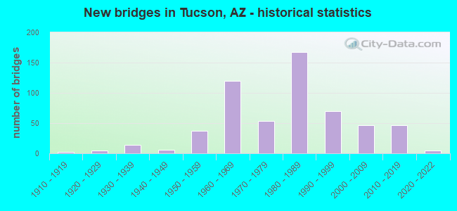
- New bridges - historical statistics
- 21910-1919
- 51920-1929
- 141930-1939
- 61940-1949
- 371950-1959
- 1201960-1969
- 541970-1979
- 1671980-1989
- 701990-1999
- 472000-2009
- 462010-2019
- 52020-2022
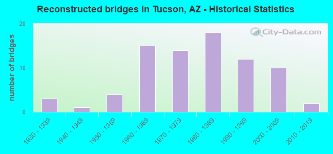
- Reconstructed bridges - Historical Statistics
- 31930-1939
- 11940-1949
- 41950-1959
- 151960-1969
- 141970-1979
- 181980-1989
- 121990-1999
- 102000-2009
- 22010-2019
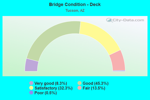
- Bridge Condition - Deck
- 8.3%Very good
- 45.3%Good
- 32.3%Satisfactory
- 13.5%Fair
- 0.5%Poor
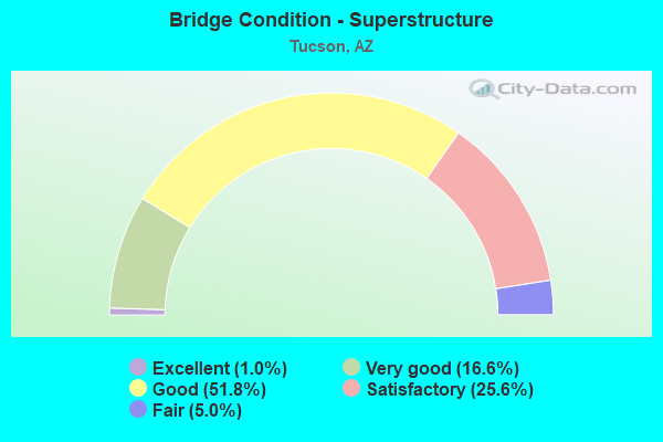
- Bridge Condition - Superstructure
- 1.0%Excellent
- 16.6%Very good
- 51.8%Good
- 25.6%Satisfactory
- 5.0%Fair
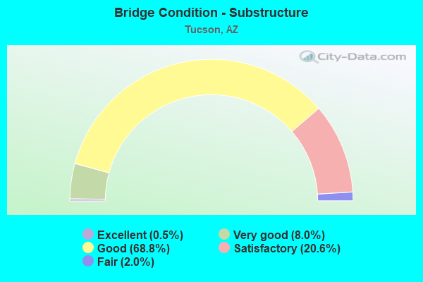
- Bridge Condition - Substructure
- 0.5%Excellent
- 8.0%Very good
- 68.8%Good
- 20.6%Satisfactory
- 2.0%Fair
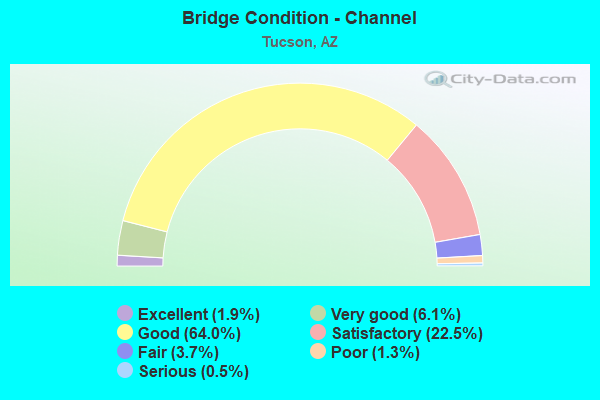
- Bridge Condition - Channel
- 1.9%Excellent
- 6.1%Very good
- 64.0%Good
- 22.5%Satisfactory
- 3.7%Fair
- 1.3%Poor
- 0.5%Serious
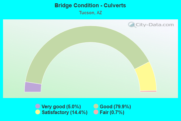
- Bridge Condition - Culverts
- 5.0%Very good
- 79.9%Good
- 14.4%Satisfactory
- 0.7%Fair
Find on map >> Show street view
Structure Number: 2659, Location: 1.6 mi E Jct I 10 (Lat: 32.215700, Lng: -110.956800), Route carried "on" structure: , Year Built: 1998, Status: Open, Structure Length: 5.94m (19.49ft), Design Load: Railroad, Features Intersected: Euclid/Park Ave, Facility Carried by Structure: SPRR Mainline
Kilometerpoint: 0.000, Lanes under structure: 6, Owner: State Highway Agency, Skew: 4 degrees, Material/Design: Prestressed concrete continuous, Design/Construction: Box Beam or Girders - Single/Spread, Number Of Spans In Main Unit: 2, Length of Maximum Span: 28.3m (92.8ft), Out-to-Out Width: 11.1m (36.4ft)
Condition: Deck: Good, Superstructure: Good, Substructure: Good, Structural Evaluation: Better than present minimum criteria, Underclear: Meets minimum limits, Designated Inspection Frequency: Every 24 months, Inspection Date: September 2020
Find on map >> Show street view
Structure Number: 266, Location: 1.6 mi E Jct I 10 (Lat: 32.215300, Lng: -110.956700), Route carried "on" structure: , Year Built: 1998, Status: Open, Structure Length: 4.48m (14.70ft), Design Load: Railroad, Features Intersected: Euclid/Park Ave, Facility Carried by Structure: SPRR Nogales
Kilometerpoint: 0.000, Lanes under structure: 6, Owner: State Highway Agency, Skew: 2 degrees, Material/Design: Prestressed concrete continuous, Design/Construction: Box Beam or Girders - Single/Spread, Number Of Spans In Main Unit: 2, Length of Maximum Span: 22.3m (73.2ft), Out-to-Out Width: 6.2m (20.3ft)
Condition: Deck: Good, Superstructure: Good, Substructure: Good, Operating Rating: 89.8 metric tons, Method Used To Determine Operating Rating: Allowable Stress (AS), Inventory Rating: 72.6 metric tons, Method Used To Determine Inventory Rating: Allowable Stress (AS), Structural Evaluation: Better than present minimum criteria, Underclear: Meets minimum limits, Designated Inspection Frequency: Every 24 months, Inspection Date: September 2020
Find on map >> Show street view
Structure Number: 2661, Location: 1.6 mi E Jct I 10 (Lat: 32.225000, Lng: -110.961111), Route carried "on" structure: City street , Year Built: 1998, Status: Open, Structure Length: 4.30m (14.11ft), Average Daily Traffic: 6,000 (year 2015), Truck Traffic: 10%, Average Future Daily Traffic: 6,010 (year 2037), Design Load: HS 20, Features Intersected: Euclid/Park Ave, Facility Carried by Structure: 16th St/Mill St
Minimum Vertical Clearance: 30+ m (98+ ft), Kilometerpoint: 0.000, Lanes on structure: 2, Lanes under structure: 6, Owner: State Highway Agency, Approaching Roadway Width: 8.5m (27.9ft), Skew: 2 degrees, Material/Design: Prestressed concrete continuous, Design/Construction: Box Beam or Girders - Single/Spread, Number Of Spans In Main Unit: 2, Length of Maximum Span: 21.6m (70.9ft), Curb or Sidewalk Widths: Left: 1.6m (5.2ft), Right: 0.0m, Curb-To-Curb Width: 8.5m (27.9ft), Out-to-Out Width: 11.4m (37.4ft)
Condition: Deck: Good, Superstructure: Good, Substructure: Good, Operating Rating: 84.4 metric tons, Method Used To Determine Operating Rating: Load Factor (LF), Inventory Rating: 46.3 metric tons, Method Used To Determine Inventory Rating: Load Factor (LF), Structural Evaluation: Better than present minimum criteria, Deck Geometry: High priority of replacement, Underclear: Meets minimum limits, Approach Roadway Alignment: Equal to present minimum criteria, Length Of Structure Improvement: 5.15m (16.90ft), Designated Inspection Frequency: Every 24 months, Inspection Date: July 2020, Total Project Cost: $1,000 ( Estimate for 2020), Deck Structure Type: Concrete Cast-file-Place, Wearing Surface/Protective System: Wearing Surface: Monolithic Concrete
Find on map >> Show street view
Structure Number: 2783, Location: 4.0 mi N Jct I-19 (Lat: 32.250600, Lng: -110.993300), Route carried "on" structure: Interstate 10, Year Built: 2009, Status: Open, Structure Length: 7.32m (24.02ft), Average Daily Traffic: 151,922 (year 2017), Truck Traffic: 19%, Average Future Daily Traffic: 151,932 (year 2037), Design Load: HS 20, Features Intersected: Grant Road
Minimum Vertical Clearance: 10.67m (35.01ft), Kilometerpoint: 412.233, Lanes on structure: 8, Lanes under structure: 6, Owner: State Highway Agency, Approaching Roadway Width: 43.6m (143.0ft), Skew: 33 degrees, Material/Design: Prestressed concrete continuous, Design/Construction: Stringer/Multi-beam, Number Of Spans In Main Unit: 2, Length of Maximum Span: 35.4m (116.1ft), Curb-To-Curb Width: 43.4m (142.4ft), Out-to-Out Width: 45.4m (149.0ft)
Condition: Deck: Good, Superstructure: Good, Substructure: Good, Operating Rating: 63.5 metric tons, Method Used To Determine Operating Rating: Load Factor (LF), Inventory Rating: 32.7 metric tons, Method Used To Determine Inventory Rating: Load Factor (LF), Structural Evaluation: Better than present minimum criteria, Deck Geometry: Superior to present desirable criteria, Underclear: Equal to present desirable criteria, Approach Roadway Alignment: Equal to present desirable criteria, Designated Inspection Frequency: Every 24 months, Inspection Date: October 2020, Deck Structure Type: Concrete Cast-file-Place, Wearing Surface/Protective System: Wearing Surface: Bituminous
Find on map >> Show street view
Structure Number: 2784, Location: 5.0 mi N Jct I-19 (Lat: 32.236000, Lng: -110.984100), Route carried "on" structure: Interstate 10, Year Built: 2009, Status: Open, Structure Length: 6.16m (20.21ft), Average Daily Traffic: 173,785 (year 2017), Truck Traffic: 19%, Average Future Daily Traffic: 173,795 (year 2038), Design Load: HS 20, Features Intersected: Speedway Blvd.
Minimum Vertical Clearance: 30+ m (98+ ft), Kilometerpoint: 414.100, Lanes on structure: 8, Lanes under structure: 6, Owner: State Highway Agency, Approaching Roadway Width: 42.1m (138.1ft), Skew: 30 degrees, Material/Design: Prestressed concrete continuous, Design/Construction: Stringer/Multi-beam, Number Of Spans In Main Unit: 2, Length of Maximum Span: 29.9m (98.1ft), Curb-To-Curb Width: 43.4m (142.4ft), Out-to-Out Width: 45.4m (149.0ft)
Condition: Deck: Good, Superstructure: Good, Substructure: Good, Operating Rating: 75.3 metric tons, Method Used To Determine Operating Rating: Load Factor (LF), Inventory Rating: 39.9 metric tons, Method Used To Determine Inventory Rating: Load Factor (LF), Structural Evaluation: Better than present minimum criteria, Deck Geometry: Superior to present desirable criteria, Underclear: Superior to present desirable criteria, Approach Roadway Alignment: Equal to present desirable criteria, Designated Inspection Frequency: Every 24 months, Inspection Date: October 2020, Deck Structure Type: Concrete Cast-file-Place, Wearing Surface/Protective System: Wearing Surface: Bituminous
Find on map >> Show street view
Structure Number: 2853, Location: 1.8 mi N Jct I-19 (Lat: 32.221100, Lng: -110.980100), Route carried "on" structure: Interstate 10, Year Built: 2009, Status: Open, Structure Length: 5.97m (19.59ft), Average Daily Traffic: 166,039 (year 2017), Truck Traffic: 19%, Average Future Daily Traffic: 166,049 (year 2037), Design Load: HS 20, Features Intersected: Congress Street
Minimum Vertical Clearance: 30+ m (98+ ft), Kilometerpoint: 415.854, Lanes on structure: 8, Lanes under structure: 8, Owner: State Highway Agency, Approaching Roadway Width: 42.1m (138.1ft), Skew: 30 degrees, Material/Design: Prestressed concrete continuous, Design/Construction: Stringer/Multi-beam, Number Of Spans In Main Unit: 2, Length of Maximum Span: 29.0m (95.1ft), Curb-To-Curb Width: 43.5m (142.7ft), Out-to-Out Width: 45.5m (149.3ft)
Condition: Deck: Very good, Superstructure: Good, Substructure: Good, Operating Rating: 89.8 metric tons, Method Used To Determine Operating Rating: Load Factor (LF), Inventory Rating: 46.3 metric tons, Method Used To Determine Inventory Rating: Load Factor (LF), Structural Evaluation: Better than present minimum criteria, Deck Geometry: Superior to present desirable criteria, Underclear: Superior to present desirable criteria, Approach Roadway Alignment: Equal to present desirable criteria, Designated Inspection Frequency: Every 24 months, Inspection Date: October 2020, Deck Structure Type: Concrete Cast-file-Place, Wearing Surface/Protective System: Wearing Surface: Bituminous
Find on map >> Show street view
Structure Number: 2854, Location: 1.6 mi N Jct I-19 (Lat: 32.217500, Lng: -110.979700), Route carried "on" structure: Interstate 10, Year Built: 2009, Status: Open, Structure Length: 7.04m (23.10ft), Average Daily Traffic: 166,039 (year 2017), Truck Traffic: 19%, Average Future Daily Traffic: 166,049 (year 2038), Design Load: HS 20, Features Intersected: Clark Street
Minimum Vertical Clearance: 30+ m (98+ ft), Kilometerpoint: 416.225, Lanes on structure: 8, Lanes under structure: 4, Owner: State Highway Agency, Approaching Roadway Width: 42.1m (138.1ft), Skew: 30 degrees, Material/Design: Prestressed concrete continuous, Design/Construction: Stringer/Multi-beam, Number Of Spans In Main Unit: 3, Length of Maximum Span: 25.9m (85.0ft), Curb-To-Curb Width: 43.5m (142.7ft), Out-to-Out Width: 45.5m (149.3ft)
Condition: Deck: Good, Superstructure: Very good, Substructure: Good, Operating Rating: 83.5 metric tons, Method Used To Determine Operating Rating: Load Factor (LF), Inventory Rating: 40.8 metric tons, Method Used To Determine Inventory Rating: Load Factor (LF), Structural Evaluation: Better than present minimum criteria, Deck Geometry: Superior to present desirable criteria, Underclear: Superior to present desirable criteria, Approach Roadway Alignment: Equal to present desirable criteria, Designated Inspection Frequency: Every 24 months, Inspection Date: October 2018, Deck Structure Type: Concrete Cast-file-Place, Wearing Surface/Protective System: Wearing Surface: Bituminous
Find on map >> Show street view
Structure Number: 2855, Location: 1.6 mi N Jct I-19 (Lat: 32.217500, Lng: -110.979300), Route carried "on" structure: Ramp Interstate 10, Year Built: 2009, Status: Open, Structure Length: 7.01m (23.00ft), Average Daily Traffic: 15,000 (year 2018), Truck Traffic: 9%, Average Future Daily Traffic: 15,010 (year 2038), Design Load: HS 20, Features Intersected: Clark Street
Minimum Vertical Clearance: 30+ m (98+ ft), Kilometerpoint: 416.225, Lanes on structure: 2, Lanes under structure: 3, Owner: State Highway Agency, Approaching Roadway Width: 11.6m (38.1ft), Material/Design: Prestressed concrete continuous, Design/Construction: Stringer/Multi-beam, Number Of Spans In Main Unit: 3, Length of Maximum Span: 25.9m (85.0ft), Curb-To-Curb Width: 11.6m (38.1ft), Out-to-Out Width: 12.6m (41.3ft)
Condition: Deck: Very good, Superstructure: Very good, Substructure: Very good, Operating Rating: 81.6 metric tons, Method Used To Determine Operating Rating: Load Factor (LF), Inventory Rating: 42.6 metric tons, Method Used To Determine Inventory Rating: Load Factor (LF), Structural Evaluation: Equal to present desirable criteria, Deck Geometry: Superior to present desirable criteria, Underclear: Superior to present desirable criteria, Approach Roadway Alignment: Equal to present desirable criteria, Designated Inspection Frequency: Every 24 months, Inspection Date: October 2020, Deck Structure Type: Concrete Cast-file-Place, Wearing Surface/Protective System: Wearing Surface: Bituminous
Find on map >> Show street view
Structure Number: 2856, Location: 1.6 mi N Jct I-19 (Lat: 32.217500, Lng: -110.980000), Route carried "on" structure: Ramp Interstate 10, Year Built: 2009, Status: Open, Structure Length: 7.04m (23.10ft), Average Daily Traffic: 14,370 (year 2018), Truck Traffic: 9%, Average Future Daily Traffic: 14,380 (year 2038), Design Load: HS 20, Features Intersected: Clark Street
Minimum Vertical Clearance: 30+ m (98+ ft), Kilometerpoint: 416.225, Lanes on structure: 2, Lanes under structure: 3, Owner: State Highway Agency, Approaching Roadway Width: 9.8m (32.2ft), Material/Design: Prestressed concrete continuous, Design/Construction: Stringer/Multi-beam, Number Of Spans In Main Unit: 3, Length of Maximum Span: 25.9m (85.0ft), Curb-To-Curb Width: 9.8m (32.2ft), Out-to-Out Width: 10.7m (35.1ft)
Condition: Deck: Very good, Superstructure: Very good, Substructure: Good, Operating Rating: 81.6 metric tons, Method Used To Determine Operating Rating: Load Factor (LF), Inventory Rating: 37.2 metric tons, Method Used To Determine Inventory Rating: Load Factor (LF), Structural Evaluation: Better than present minimum criteria, Deck Geometry: Equal to present minimum criteria, Underclear: Superior to present desirable criteria, Approach Roadway Alignment: Equal to present desirable criteria, Designated Inspection Frequency: Every 24 months, Inspection Date: October 2020, Deck Structure Type: Concrete Cast-file-Place, Wearing Surface/Protective System: Wearing Surface: Bituminous
Find on map >> Show street view
Structure Number: 2857, Location: 1.2 mi N Jct I-19 (Lat: 32.212200, Lng: -110.979600), Route carried "on" structure: Interstate 10, Year Built: 2009, Status: Open, Structure Length: 3.84m (12.60ft), Average Daily Traffic: 166,039 (year 2017), Truck Traffic: 19%, Average Future Daily Traffic: 166,049 (year 2037), Design Load: HS 20, Features Intersected: 18th Street
Minimum Vertical Clearance: 30+ m (98+ ft), Kilometerpoint: 416.820, Lanes on structure: 11, Owner: State Highway Agency, Approaching Roadway Width: 50.9m (167.0ft), Skew: 30 degrees, Material/Design: Prestressed concrete, Design/Construction: Box Beam or Girders - Single/Spread, Number Of Spans In Main Unit: 1, Length of Maximum Span: 36.9m (121.1ft), Curb-To-Curb Width: 56.4m (185.0ft), Out-to-Out Width: 58.3m (191.3ft)
Condition: Deck: Good, Superstructure: Good, Substructure: Good, Operating Rating: 89.8 metric tons, Method Used To Determine Operating Rating: Load Factor (LF), Inventory Rating: 65.3 metric tons, Method Used To Determine Inventory Rating: Load Factor (LF), Structural Evaluation: Better than present minimum criteria, Deck Geometry: Superior to present desirable criteria, Approach Roadway Alignment: Equal to present desirable criteria, Designated Inspection Frequency: Every 24 months, Inspection Date: October 2020, Deck Structure Type: Concrete Cast-file-Place, Wearing Surface/Protective System: Wearing Surface: Bituminous
Find on map >> Show street view
Structure Number: 2858, Location: 1.0 mi N Jct I-19 (Lat: 32.207000, Lng: -110.979600), Route carried "on" structure: Interstate 10, Year Built: 2009, Status: Open, Structure Length: 5.97m (19.59ft), Average Daily Traffic: 166,039 (year 2017), Truck Traffic: 19%, Average Future Daily Traffic: 166,049 (year 2037), Design Load: HS 20, Features Intersected: 22nd Street
Minimum Vertical Clearance: 30+ m (98+ ft), Kilometerpoint: 417.383, Lanes on structure: 8, Lanes under structure: 6, Owner: State Highway Agency, Approaching Roadway Width: 42.1m (138.1ft), Skew: 30 degrees, Material/Design: Prestressed concrete continuous, Design/Construction: Stringer/Multi-beam, Number Of Spans In Main Unit: 2, Length of Maximum Span: 29.0m (95.1ft), Curb-To-Curb Width: 43.5m (142.7ft), Out-to-Out Width: 45.5m (149.3ft)
Condition: Deck: Good, Superstructure: Very good, Substructure: Good, Operating Rating: 89.8 metric tons, Method Used To Determine Operating Rating: Load Factor (LF), Inventory Rating: 46.3 metric tons, Method Used To Determine Inventory Rating: Load Factor (LF), Structural Evaluation: Better than present minimum criteria, Deck Geometry: Superior to present desirable criteria, Underclear: Superior to present desirable criteria, Approach Roadway Alignment: Equal to present desirable criteria, Designated Inspection Frequency: Every 24 months, Inspection Date: October 2020, Deck Structure Type: Concrete Cast-file-Place, Wearing Surface/Protective System: Wearing Surface: Bituminous
Find on map >> Show street view
Structure Number: 2895, Location: 0.9 mi N Jct SR 77 (Lat: 32.275000, Lng: -111.016667), Route carried "on" structure: City street , Year Built: 2013, Status: Open, Structure Length: 6.98m (22.90ft), Average Daily Traffic: 10,000 (year 2019), Truck Traffic: 10%, Average Future Daily Traffic: 10,010 (year 2039), Design Load: HS 20, Features Intersected: I-10, Facility Carried by Structure: Prince Rd
Minimum Vertical Clearance: 30+ m (98+ ft), Kilometerpoint: 0.000, Lanes on structure: 7, Lanes under structure: 8, Owner: State Highway Agency, Approaching Roadway Width: 31.1m (102.0ft), Skew: 21 degrees, Material/Design: Prestressed concrete, Design/Construction: Stringer/Multi-beam, Number Of Spans In Main Unit: 2, Length of Maximum Span: 34.1m (111.9ft), Curb or Sidewalk Widths: Left: 3.0m (9.8ft), Right: 3.0m (9.8ft), Curb-To-Curb Width: 31.1m (102.0ft), Out-to-Out Width: 37.9m (124.3ft)
Condition: Deck: Very good, Superstructure: Very good, Substructure: Very good, Operating Rating: 87.1 metric tons, Method Used To Determine Operating Rating: Load Factor (LF), Inventory Rating: 34.5 metric tons, Method Used To Determine Inventory Rating: Load Factor (LF), Structural Evaluation: Equal to present desirable criteria, Deck Geometry: Better than present minimum criteria, Underclear: Equal to present minimum criteria, Approach Roadway Alignment: Equal to present desirable criteria, Designated Inspection Frequency: Every 24 months, Inspection Date: July 2020, Deck Structure Type: Concrete Cast-file-Place, Wearing Surface/Protective System: Wearing Surface: Monolithic Concrete
Find on map >> Show street view
Structure Number: 2896, Location: 280' E Jct I-10 (Lat: 32.275000, Lng: -111.016667), Route carried "on" structure: City street , Year Built: 2013, Status: Open, Structure Length: 3.63m (11.91ft), Average Daily Traffic: 10,000 (year 2019), Truck Traffic: 10%, Average Future Daily Traffic: 10,010 (year 2039), Design Load: HS 20, Features Intersected: Union Pacific RR, Facility Carried by Structure: Prince Road
Minimum Vertical Clearance: 30+ m (98+ ft), Kilometerpoint: 0.000, Lanes on structure: 7, Owner: State Highway Agency, Approaching Roadway Width: 35.4m (116.1ft), Skew: 21 degrees, Material/Design: Prestressed concrete, Design/Construction: Stringer/Multi-beam, Number Of Spans In Main Unit: 1, Length of Maximum Span: 34.1m (111.9ft), Curb or Sidewalk Widths: Left: 5.9m (19.4ft), Right: 9.2m (30.2ft), Curb-To-Curb Width: 35.4m (116.1ft), Out-to-Out Width: 51.2m (168.0ft)
Condition: Deck: Good, Superstructure: Very good, Substructure: Good, Operating Rating: 89.8 metric tons, Method Used To Determine Operating Rating: Load Factor (LF), Inventory Rating: 38.1 metric tons, Method Used To Determine Inventory Rating: Load Factor (LF), Structural Evaluation: Better than present minimum criteria, Deck Geometry: Superior to present desirable criteria, Underclear: Superior to present desirable criteria, Approach Roadway Alignment: Equal to present desirable criteria, Designated Inspection Frequency: Every 24 months, Inspection Date: July 2020, Deck Structure Type: Concrete Cast-file-Place, Wearing Surface/Protective System: Wearing Surface: Monolithic Concrete
Find on map >> Show street view
Structure Number: 2994, Location: 475 ft W Jct I-10 (Lat: 32.275000, Lng: -111.019444), Route carried "on" structure: City street , Year Built: 2013, Status: Open, Structure Length: 4.15m (13.62ft), Average Daily Traffic: 9,516 (year 2017), Truck Traffic: 10%, Average Future Daily Traffic: 9,526 (year 2037), Design Load: HS 20, Features Intersected: Utility Corridor, Facility Carried by Structure: Prince Road
Minimum Vertical Clearance: 30+ m (98+ ft), Kilometerpoint: 0.000, Lanes on structure: 5, Owner: State Highway Agency, Approaching Roadway Width: 28.0m (91.9ft), Skew: 1 degrees, Material/Design: Prestressed concrete, Design/Construction: Stringer/Multi-beam, Number Of Spans In Main Unit: 1, Length of Maximum Span: 39.6m (129.9ft), Curb or Sidewalk Widths: Left: 3.0m (9.8ft), Right: 3.0m (9.8ft), Curb-To-Curb Width: 30.0m (98.4ft), Out-to-Out Width: 37.1m (121.7ft)
Condition: Deck: Very good, Superstructure: Very good, Substructure: Good, Operating Rating: 89.8 metric tons, Method Used To Determine Operating Rating: Load Factor (LF), Inventory Rating: 37.2 metric tons, Method Used To Determine Inventory Rating: Load Factor (LF), Structural Evaluation: Better than present minimum criteria, Deck Geometry: Superior to present desirable criteria, Approach Roadway Alignment: Equal to present minimum criteria, Designated Inspection Frequency: Every 24 months, Inspection Date: July 2020, Deck Structure Type: Concrete Cast-file-Place, Wearing Surface/Protective System: Wearing Surface: Monolithic Concrete
Find on map >> Show street view
Structure Number: 4158, Location: 3.9 mi W Jct SR 73 (Lat: 33.982400, Lng: -110.302100), Route carried "on" structure: US 60, Year Built: 1953, Status: Open, Structure Length: 0.73m (2.40ft), Average Daily Traffic: 2,788 (year 2020), Truck Traffic: 11%, Average Future Daily Traffic: 2,798 (year 2040), Design Load: HS 20, Features Intersected: Wash
Minimum Vertical Clearance: 30+ m (98+ ft), Kilometerpoint: 505.880, Lanes on structure: 2, Owner: State Highway Agency, Approaching Roadway Width: 10.7m (35.1ft), Skew: 3 degrees, Material/Design: Concrete continuous, Design/Construction: Culvert, Number Of Spans In Main Unit: 2, Length of Maximum Span: 3.0m (9.8ft)
Condition: Channel: Good, Culverts: Good, Operating Rating: 89.8 metric tons, Method Used To Determine Operating Rating: Load Factor (LF), Inventory Rating: 89.8 metric tons, Method Used To Determine Inventory Rating: Load Factor (LF), Structural Evaluation: Better than present minimum criteria, Waterway Adequacy: Better than present minimum criteria, Approach Roadway Alignment: Equal to present desirable criteria, Length Of Structure Improvement: 1.46m (4.79ft), Designated Inspection Frequency: Every 48 months, Inspection Date: March 2021, Total Project Cost: $1,000 ( Estimate for 2021)
Find on map >> Show street view
Structure Number: 4624, Location: 1.0 mi W Jct I-19 (Lat: 32.177900, Lng: -111.001400), Route carried "on" structure: State highway 86, Year Built: 1962, Status: Open, Structure Length: 1.16m (3.81ft), Average Daily Traffic: 34,035 (year 2019), Truck Traffic: 11%, Average Future Daily Traffic: 46,944 (year 2040), Design Load: HS 20, Features Intersected: Wash
Minimum Vertical Clearance: 30+ m (98+ ft), Kilometerpoint: 274.313, Lanes on structure: 4, Owner: State Highway Agency, Approaching Roadway Width: 19.5m (64.0ft), Material/Design: Concrete continuous, Design/Construction: Culvert, Number Of Spans In Main Unit: 3, Length of Maximum Span: 3.7m (12.1ft), Curb or Sidewalk Widths: Left: 1.8m (5.9ft), Right: 1.8m (5.9ft), Curb-To-Curb Width: 19.5m (64.0ft), Out-to-Out Width: 23.8m (78.1ft)
Condition: Channel: Good, Culverts: Good, Operating Rating: 49.0 metric tons, Method Used To Determine Operating Rating: Load Factor (LF), Inventory Rating: 29.0 metric tons, Method Used To Determine Inventory Rating: Load Factor (LF), Structural Evaluation: Better than present minimum criteria, Deck Geometry: Better than present minimum criteria, Waterway Adequacy: Better than present minimum criteria, Approach Roadway Alignment: Equal to present minimum criteria, Length Of Structure Improvement: 1.16m (3.81ft), Designated Inspection Frequency: Every 48 months, Inspection Date: June 2021, Bridge Improvement Cost: $2,000, Roadway Improvement Cost: $1,000, Total Project Cost: $3,000 ( Estimate for 2021), Deck Structure Type: Concrete Cast-file-Place, Wearing Surface/Protective System: Wearing Surface: Bituminous
Find on map >> Show street view
Structure Number: 4728, Location: 350' S Jct Ft Lowell Rd (Lat: 32.263700, Lng: -110.978100), Route carried "on" structure: State highway 77, Year Built: 1965, Year Reconstructed: 1979, Status: Open, Structure Length: 0.76m (2.49ft), Average Daily Traffic: 40,463 (year 2016), Truck Traffic: 9%, Average Future Daily Traffic: 40,473 (year 2038), Design Load: HS 20, Features Intersected: Cemetery Wash
Minimum Vertical Clearance: 30+ m (98+ ft), Kilometerpoint: 112.270, Lanes on structure: 6, Owner: State Highway Agency, Approaching Roadway Width: 29.3m (96.1ft), Skew: 21 degrees, Material/Design: Concrete continuous, Design/Construction: Culvert, Number Of Spans In Main Unit: 2, Length of Maximum Span: 3.7m (12.1ft), Curb or Sidewalk Widths: Left: 1.4m (4.6ft), Right: 1.4m (4.6ft), Curb-To-Curb Width: 29.3m (96.1ft), Out-to-Out Width: 41.8m (137.1ft)
Condition: Channel: Good, Culverts: Good, Operating Rating: 59.0 metric tons, Method Used To Determine Operating Rating: Load Factor (LF), Inventory Rating: 34.5 metric tons, Method Used To Determine Inventory Rating: Load Factor (LF), Structural Evaluation: Better than present minimum criteria, Deck Geometry: Superior to present desirable criteria, Waterway Adequacy: Better than present minimum criteria, Approach Roadway Alignment: Equal to present desirable criteria, Designated Inspection Frequency: Every 48 months, Inspection Date: Febuary 2022, Deck Structure Type: Concrete Cast-file-Place, Wearing Surface/Protective System: Wearing Surface: Bituminous
Find on map >> Show street view
Structure Number: 4729, Location: 1.8 mi NE Jct I-10 (Lat: 32.266500, Lng: -110.978100), Route carried "on" structure: State highway 77, Year Built: 1965, Year Reconstructed: 1979, Status: Open, Structure Length: 1.19m (3.90ft), Average Daily Traffic: 40,463 (year 2016), Truck Traffic: 9%, Average Future Daily Traffic: 40,473 (year 2037), Design Load: HS 20, Features Intersected: Navajo Wash
Minimum Vertical Clearance: 30+ m (98+ ft), Kilometerpoint: 112.570, Lanes on structure: 7, Owner: State Highway Agency, Approaching Roadway Width: 29.3m (96.1ft), Skew: 21 degrees, Material/Design: Concrete continuous, Design/Construction: Culvert, Number Of Spans In Main Unit: 3, Length of Maximum Span: 3.7m (12.1ft), Curb or Sidewalk Widths: Left: 1.4m (4.6ft), Right: 1.4m (4.6ft), Curb-To-Curb Width: 29.3m (96.1ft), Out-to-Out Width: 38.4m (126.0ft)
Condition: Channel: Satisfactory, Culverts: Good, Operating Rating: 54.4 metric tons, Method Used To Determine Operating Rating: Load Factor (LF), Inventory Rating: 32.7 metric tons, Method Used To Determine Inventory Rating: Load Factor (LF), Structural Evaluation: Better than present minimum criteria, Deck Geometry: Somewhat better than minimum adequacy, Waterway Adequacy: Better than present minimum criteria, Approach Roadway Alignment: Equal to present desirable criteria, Designated Inspection Frequency: Every 48 months, Inspection Date: Febuary 2022, Deck Structure Type: Concrete Cast-file-Place, Wearing Surface/Protective System: Wearing Surface: Bituminous
Find on map >> Show street view
Structure Number: 4731, Location: 14.3 mi S Jct SR 79 (Lat: 32.363100, Lng: -110.971000), Route carried "on" structure: State highway 77, Year Built: 1953, Year Reconstructed: 1979, Status: Open, Structure Length: 1.65m (5.41ft), Average Daily Traffic: 45,414 (year 2016), Truck Traffic: 9%, Average Future Daily Traffic: 45,424 (year 2038), Design Load: HS 20, Features Intersected: Wash
Minimum Vertical Clearance: 30+ m (98+ ft), Kilometerpoint: 123.450, Lanes on structure: 7, Owner: State Highway Agency, Approaching Roadway Width: 34.1m (111.9ft), Skew: 20 degrees, Material/Design: Concrete continuous, Design/Construction: Culvert, Number Of Spans In Main Unit: 5, Length of Maximum Span: 3.0m (9.8ft)
Condition: Channel: Good, Culverts: Good, Operating Rating: 50.8 metric tons, Method Used To Determine Operating Rating: Load Factor (LF), Inventory Rating: 29.9 metric tons, Method Used To Determine Inventory Rating: Load Factor (LF), Structural Evaluation: Better than present minimum criteria, Waterway Adequacy: Better than present minimum criteria, Approach Roadway Alignment: Equal to present desirable criteria, Length Of Structure Improvement: 2.41m (7.91ft), Designated Inspection Frequency: Every 48 months, Inspection Date: Febuary 2022, Bridge Improvement Cost: $1,000, Roadway Improvement Cost: $1,000, Total Project Cost: $2,000 ( Estimate for 2018)
Find on map >> Show street view
Structure Number: 4732, Location: 12.1 mi S Jct SR 79 (Lat: 32.393100, Lng: -110.962500), Route carried "on" structure: State highway 77, Year Built: 1953, Year Reconstructed: 2008, Status: Open, Structure Length: 1.65m (5.41ft), Average Daily Traffic: 22,691 (year 2016), Truck Traffic: 9%, Average Future Daily Traffic: 22,701 (year 2038), Design Load: HS 20, Features Intersected: Wash
Minimum Vertical Clearance: 30+ m (98+ ft), Kilometerpoint: 127.030, Lanes on structure: 6, Owner: State Highway Agency, Approaching Roadway Width: 34.1m (111.9ft), Skew: 20 degrees, Material/Design: Concrete continuous, Design/Construction: Culvert, Number Of Spans In Main Unit: 5, Length of Maximum Span: 3.0m (9.8ft)
Condition: Channel: Good, Culverts: Good, Operating Rating: 89.8 metric tons, Method Used To Determine Operating Rating: Load Factor (LF), Inventory Rating: 89.8 metric tons, Method Used To Determine Inventory Rating: Load Factor (LF), Structural Evaluation: Better than present minimum criteria, Waterway Adequacy: Better than present minimum criteria, Approach Roadway Alignment: Equal to present desirable criteria, Length Of Structure Improvement: 2.41m (7.91ft), Designated Inspection Frequency: Every 48 months, Inspection Date: January 2018, Bridge Improvement Cost: $1,000, Roadway Improvement Cost: $1,000, Total Project Cost: $2,000 ( Estimate for 2018)
Find on map >> Show street view
Structure Number: 4744, Location: 21.2 mi N Jct SR 77 (Lat: 32.782500, Lng: -111.167800), Route carried "on" structure: State highway 79, Year Built: 1946, Status: Open, Structure Length: 0.98m (3.22ft), Average Daily Traffic: 2,613 (year 2016), Truck Traffic: 11%, Average Future Daily Traffic: 2,623 (year 2038), Design Load: HS 20, Features Intersected: Wash
Minimum Vertical Clearance: 30+ m (98+ ft), Kilometerpoint: 180.610, Lanes on structure: 2, Owner: State Highway Agency, Approaching Roadway Width: 9.4m (30.8ft), Material/Design: Concrete continuous, Design/Construction: Culvert, Number Of Spans In Main Unit: 3, Length of Maximum Span: 3.0m (9.8ft)
Condition: Channel: Satisfactory, Culverts: Good, Operating Rating: 53.5 metric tons, Method Used To Determine Operating Rating: Load Factor (LF), Inventory Rating: 32.7 metric tons, Method Used To Determine Inventory Rating: Load Factor (LF), Structural Evaluation: Better than present minimum criteria, Waterway Adequacy: Better than present minimum criteria, Approach Roadway Alignment: Better than present minimum criteria, Designated Inspection Frequency: Every 48 months, Inspection Date: Febuary 2018, Deck Structure Type: Concrete Cast-file-Place, Wearing Surface/Protective System: Wearing Surface: Bituminous
Find on map >> Show street view
Structure Number: 5219, Location: 130' W Jct Flowing Wells (Lat: 32.261200, Lng: -110.995500), Route carried "on" structure: State highway 77, Year Built: 1931, Year Reconstructed: 1957, Status: Open, Structure Length: 1.22m (4.00ft), Average Daily Traffic: 36,824 (year 2016), Truck Traffic: 9%, Average Future Daily Traffic: 36,834 (year 2037), Design Load: HS 20, Features Intersected: Wash
Minimum Vertical Clearance: 30+ m (98+ ft), Kilometerpoint: 110.270, Lanes on structure: 6, Owner: State Highway Agency, Approaching Roadway Width: 26.2m (86.0ft), Skew: 23 degrees, Material/Design: Concrete continuous, Design/Construction: Culvert, Number Of Spans In Main Unit: 4, Length of Maximum Span: 2.4m (7.9ft), Curb or Sidewalk Widths: Left: 1.2m (3.9ft), Right: 2.4m (7.9ft), Curb-To-Curb Width: 26.2m (86.0ft), Out-to-Out Width: 32.9m (107.9ft)
Condition: Channel: Good, Culverts: Good, Operating Rating: 48.1 metric tons, Method Used To Determine Operating Rating: Load Factor (LF), Inventory Rating: 29.0 metric tons, Method Used To Determine Inventory Rating: Load Factor (LF), Structural Evaluation: Better than present minimum criteria, Deck Geometry: Equal to present minimum criteria, Waterway Adequacy: Better than present minimum criteria, Approach Roadway Alignment: Equal to present desirable criteria, Designated Inspection Frequency: Every 48 months, Inspection Date: Febuary 2022, Deck Structure Type: Concrete Cast-file-Place, Wearing Surface/Protective System: Wearing Surface: Bituminous
Find on map >> Show street view
Structure Number: 5551, Location: 9.2 mi W Jct SR B10 (Lat: 32.227600, Lng: -110.981800), Route carried "on" structure: Interstate 10, Year Built: 1950, Year Reconstructed: 1960, Status: Open, Structure Length: 1.16m (3.81ft), Average Daily Traffic: 175,000 (year 2020), Truck Traffic: 9%, Average Future Daily Traffic: 175,010 (year 2040), Design Load: HS 20, Features Intersected: Wash
Minimum Vertical Clearance: 30+ m (98+ ft), Kilometerpoint: 415.200, Lanes on structure: 14, Owner: State Highway Agency, Approaching Roadway Width: 57.3m (188.0ft), Material/Design: Concrete continuous, Design/Construction: Culvert, Number Of Spans In Main Unit: 3, Length of Maximum Span: 3.7m (12.1ft)
Condition: Channel: Good, Culverts: Good, Operating Rating: 89.8 metric tons, Method Used To Determine Operating Rating: Load Factor (LF), Inventory Rating: 89.8 metric tons, Method Used To Determine Inventory Rating: Load Factor (LF), Structural Evaluation: Better than present minimum criteria, Waterway Adequacy: Equal to present desirable criteria, Approach Roadway Alignment: Equal to present desirable criteria, Length Of Structure Improvement: 1.16m (3.81ft), Designated Inspection Frequency: Every 48 months, Inspection Date: December 2021, Bridge Improvement Cost: $1,000, Roadway Improvement Cost: $1,000, Total Project Cost: $2,000 ( Estimate for 2021)
Find on map >> Show street view
Structure Number: 5552, Location: 1.5 mi N Jct I-19 (Lat: 32.212900, Lng: -110.979600), Route carried "on" structure: Interstate 10, Year Built: 1951, Year Reconstructed: 2000, Status: Open, Structure Length: 1.13m (3.71ft), Average Daily Traffic: 169,529 (year 2020), Truck Traffic: 9%, Average Future Daily Traffic: 169,539 (year 2040), Design Load: HS 20, Features Intersected: Wash
Minimum Vertical Clearance: 5.49m (18.01ft), Kilometerpoint: 416.880, Lanes on structure: 14, Owner: State Highway Agency, Approaching Roadway Width: 11.6m (38.1ft), Skew: 33 degrees, Material/Design: Concrete continuous, Design/Construction: Culvert, Number Of Spans In Main Unit: 3, Length of Maximum Span: 3.0m (9.8ft), Curb or Sidewalk Widths: Left: 1.8m (5.9ft), Right: 2.4m (7.9ft)
Condition: Channel: Very good, Culverts: Good, Operating Rating: 89.8 metric tons, Method Used To Determine Operating Rating: Load Factor (LF), Inventory Rating: 89.8 metric tons, Method Used To Determine Inventory Rating: Load Factor (LF), Structural Evaluation: Better than present minimum criteria, Waterway Adequacy: Equal to present desirable criteria, Approach Roadway Alignment: Equal to present desirable criteria, Length Of Structure Improvement: 1.89m (6.20ft), Designated Inspection Frequency: Every 48 months, Inspection Date: November 2021, Total Project Cost: $1,000 ( Estimate for 2021)
Find on map >> Show street view
Structure Number: 5555, Location: 1.3 mi E Jct SR B10 (Lat: 32.151500, Lng: -110.899000), Route carried "on" structure: Interstate 10, Year Built: 1967, Status: Open, Structure Length: 2.26m (7.41ft), Average Daily Traffic: 70,636 (year 2020), Truck Traffic: 31%, Average Future Daily Traffic: 70,646 (year 2040), Design Load: HS 20, Features Intersected: Julian Wash
Minimum Vertical Clearance: 30+ m (98+ ft), Kilometerpoint: 427.940, Lanes on structure: 4, Owner: State Highway Agency, Approaching Roadway Width: 21.9m (71.9ft), Skew: 23 degrees, Material/Design: Concrete continuous, Design/Construction: Culvert, Number Of Spans In Main Unit: 6, Length of Maximum Span: 3.0m (9.8ft)
Condition: Channel: Fair, Culverts: Satisfactory, Operating Rating: 89.8 metric tons, Method Used To Determine Operating Rating: Load Factor (LF), Inventory Rating: 89.8 metric tons, Method Used To Determine Inventory Rating: Load Factor (LF), Structural Evaluation: Equal to present minimum criteria, Waterway Adequacy: Equal to present desirable criteria, Approach Roadway Alignment: Equal to present desirable criteria, Length Of Structure Improvement: 2.26m (7.41ft), Designated Inspection Frequency: Every 48 months, Inspection Date: December 2021, Bridge Improvement Cost: $1,000, Total Project Cost: $2,000 ( Estimate for 2021)
Find on map >> Show street view
Structure Number: 5828, Location: 4.5 mi S Jct I 10 (Lat: 32.130639, Lng: -110.986611), Route carried "on" structure: Interstate 19, Year Built: 1965, Status: Open, Structure Length: 1.31m (4.30ft), Average Daily Traffic: 44,120 (year 2014), Truck Traffic: 5%, Average Future Daily Traffic: 44,130 (year 2034), Design Load: HS 20, Features Intersected: El Vado Wash
Minimum Vertical Clearance: 30+ m (98+ ft), Kilometerpoint: 94.291, Lanes on structure: 8, Owner: State Highway Agency, Approaching Roadway Width: 41.5m (136.2ft), Skew: 30 degrees, Material/Design: Concrete continuous, Design/Construction: Culvert, Number Of Spans In Main Unit: 4, Length of Maximum Span: 3.0m (9.8ft)
Condition: Channel: Very good, Culverts: Very good, Operating Rating: 89.8 metric tons, Method Used To Determine Operating Rating: Load Factor (LF), Inventory Rating: 89.8 metric tons, Method Used To Determine Inventory Rating: Load Factor (LF), Structural Evaluation: Equal to present desirable criteria, Waterway Adequacy: Equal to present desirable criteria, Approach Roadway Alignment: Equal to present desirable criteria, Length Of Structure Improvement: 2.04m (6.69ft), Designated Inspection Frequency: Every 48 months, Inspection Date: January 2020, Bridge Improvement Cost: $1,000, Roadway Improvement Cost: $1,000, Total Project Cost: $3,000 ( Estimate for 2016)
Find on map >> Show street view
Structure Number: 583, Location: 4.0 mi S Jct I 10 (Lat: 32.137556, Lng: -110.986639), Route carried "on" structure: Interstate 19, Year Built: 1965, Status: Open, Structure Length: 1.31m (4.30ft), Average Daily Traffic: 65,967 (year 2014), Truck Traffic: 5%, Average Future Daily Traffic: 65,977 (year 2034), Design Load: HS 20, Features Intersected: Wash
Minimum Vertical Clearance: 30+ m (98+ ft), Kilometerpoint: 95.048, Lanes on structure: 7, Owner: State Highway Agency, Approaching Roadway Width: 39.6m (129.9ft), Skew: 30 degrees, Material/Design: Concrete continuous, Design/Construction: Culvert, Number Of Spans In Main Unit: 4, Length of Maximum Span: 3.0m (9.8ft)
Condition: Channel: Good, Culverts: Good, Operating Rating: 62.6 metric tons, Method Used To Determine Operating Rating: Load Factor (LF), Inventory Rating: 38.1 metric tons, Method Used To Determine Inventory Rating: Load Factor (LF), Structural Evaluation: Better than present minimum criteria, Waterway Adequacy: Equal to present desirable criteria, Approach Roadway Alignment: Equal to present desirable criteria, Length Of Structure Improvement: 2.04m (6.69ft), Designated Inspection Frequency: Every 48 months, Inspection Date: January 2020, Bridge Improvement Cost: $1,000, Roadway Improvement Cost: $1,000, Total Project Cost: $3,000 ( Estimate for 2016)
Find on map >> Show street view
Structure Number: 6511, Location: 2.6 mi S Jct I 10 (Lat: 32.157306, Lng: -110.986167), Route carried "on" structure: Interstate 19, Year Built: 1964, Year Reconstructed: 1992, Status: Open, Structure Length: 0.64m (2.10ft), Average Daily Traffic: 65,967 (year 2014), Truck Traffic: 5%, Average Future Daily Traffic: 65,977 (year 2034), Design Load: HS 20, Features Intersected: Wash
Minimum Vertical Clearance: 30+ m (98+ ft), Kilometerpoint: 97.317, Lanes on structure: 4, Owner: State Highway Agency, Approaching Roadway Width: 25.0m (82.0ft), Skew: 30 degrees, Material/Design: Concrete continuous, Design/Construction: Culvert, Number Of Spans In Main Unit: 2, Length of Maximum Span: 3.0m (9.8ft)
Condition: Channel: Satisfactory, Culverts: Good, Operating Rating: 89.8 metric tons, Method Used To Determine Operating Rating: Load Factor (LF), Inventory Rating: 89.8 metric tons, Method Used To Determine Inventory Rating: Load Factor (LF), Structural Evaluation: Better than present minimum criteria, Waterway Adequacy: Equal to present desirable criteria, Approach Roadway Alignment: Equal to present desirable criteria, Length Of Structure Improvement: 1.16m (3.81ft), Designated Inspection Frequency: Every 48 months, Inspection Date: January 2020, Total Project Cost: $2,000 ( Estimate for 2016)
Find on map >> Show street view
Structure Number: 6514, Location: 1.3 mi S Jct I 10 (Lat: 32.176389, Lng: -110.985611), Route carried "on" structure: Interstate 19, Year Built: 1964, Status: Open, Structure Length: 2.07m (6.79ft), Average Daily Traffic: 82,962 (year 2014), Truck Traffic: 5%, Average Future Daily Traffic: 82,972 (year 2034), Design Load: HS 20, Features Intersected: Rodeo Wash
Minimum Vertical Clearance: 30+ m (98+ ft), Kilometerpoint: 99.463, Lanes on structure: 6, Owner: State Highway Agency, Approaching Roadway Width: 33.5m (109.9ft), Skew: 34 degrees, Material/Design: Concrete continuous, Design/Construction: Culvert, Number Of Spans In Main Unit: 5, Length of Maximum Span: 2.7m (8.9ft)
Condition: Channel: Good, Culverts: Good, Operating Rating: 89.8 metric tons, Method Used To Determine Operating Rating: Load Factor (LF), Inventory Rating: 77.1 metric tons, Method Used To Determine Inventory Rating: Load Factor (LF), Structural Evaluation: Better than present minimum criteria, Waterway Adequacy: Equal to present desirable criteria, Approach Roadway Alignment: Equal to present desirable criteria, Length Of Structure Improvement: 2.77m (9.09ft), Designated Inspection Frequency: Every 48 months, Inspection Date: January 2020, Bridge Improvement Cost: $2,000, Roadway Improvement Cost: $1,000, Total Project Cost: $4,000 ( Estimate for 2016)
Find on map >> Show street view
Structure Number: 6515, Location: 2.5 mi W Jct SR 83 (Lat: 32.031300, Lng: -110.723300), Route carried "on" structure: ServiceState highway 10, Year Built: 1928, Status: Open, Structure Length: 0.64m (2.10ft), Average Daily Traffic: 30 (year 2020), Average Future Daily Traffic: 40 (year 2040), Design Load: HS 20, Features Intersected: Wash
Minimum Vertical Clearance: 30+ m (98+ ft), Kilometerpoint: 449.168, Lanes on structure: 2, Owner: State Highway Agency, Approaching Roadway Width: 6.4m (21.0ft), Material/Design: Concrete continuous, Design/Construction: Culvert, Number Of Spans In Main Unit: 2, Length of Maximum Span: 3.0m (9.8ft)
Condition: Channel: Poor, Culverts: Good, Operating Rating: 64.4 metric tons, Method Used To Determine Operating Rating: Load Factor (LF), Inventory Rating: 38.1 metric tons, Method Used To Determine Inventory Rating: Load Factor (LF), Structural Evaluation: Better than present minimum criteria, Waterway Adequacy: Equal to present minimum criteria, Approach Roadway Alignment: Equal to present desirable criteria, Designated Inspection Frequency: Every 24 months, Inspection Date: November 2021
Find on map >> Show street view
Structure Number: 6754, Location: 8.0 mi NE Jct I-10 (Lat: 32.348700, Lng: -110.975600), Route carried "on" structure: State highway 77, Year Built: 1979, Year Reconstructed: 2004, Status: Open, Structure Length: 0.79m (2.59ft), Average Daily Traffic: 45,414 (year 2016), Truck Traffic: 9%, Average Future Daily Traffic: 45,424 (year 2037), Design Load: HS 20, Features Intersected: Wash
Minimum Vertical Clearance: 30+ m (98+ ft), Kilometerpoint: 121.970, Lanes on structure: 6, Owner: State Highway Agency, Approaching Roadway Width: 29.3m (96.1ft), Skew: 20 degrees, Material/Design: Concrete continuous, Design/Construction: Culvert, Number Of Spans In Main Unit: 3, Length of Maximum Span: 2.4m (7.9ft)
Condition: Channel: Good, Culverts: Good, Operating Rating: 89.8 metric tons, Method Used To Determine Operating Rating: Load Factor (LF), Inventory Rating: 89.8 metric tons, Method Used To Determine Inventory Rating: Load Factor (LF), Structural Evaluation: Better than present minimum criteria, Waterway Adequacy: Better than present minimum criteria, Approach Roadway Alignment: Equal to present desirable criteria, Length Of Structure Improvement: 1.52m (4.99ft), Designated Inspection Frequency: Every 48 months, Inspection Date: Febuary 2022, Roadway Improvement Cost: $1,000, Total Project Cost: $2,000 ( Estimate for 2018)
Find on map >> Show street view
Structure Number: 6755, Location: 13.9 mi S Jct SR 79 (Lat: 32.368400, Lng: -110.968700), Route carried "on" structure: State highway 77, Year Built: 1953, Year Reconstructed: 1979, Status: Open, Structure Length: 0.79m (2.59ft), Average Daily Traffic: 49,290 (year 2016), Truck Traffic: 9%, Average Future Daily Traffic: 49,300 (year 2038), Design Load: HS 20, Features Intersected: Wash
Minimum Vertical Clearance: 30+ m (98+ ft), Kilometerpoint: 124.080, Lanes on structure: 7, Owner: State Highway Agency, Approaching Roadway Width: 34.1m (111.9ft), Skew: 20 degrees, Material/Design: Concrete continuous, Design/Construction: Culvert, Number Of Spans In Main Unit: 3, Length of Maximum Span: 2.4m (7.9ft)
Condition: Channel: Good, Culverts: Good, Operating Rating: 89.8 metric tons, Method Used To Determine Operating Rating: Load Factor (LF), Inventory Rating: 89.8 metric tons, Method Used To Determine Inventory Rating: Load Factor (LF), Structural Evaluation: Better than present minimum criteria, Waterway Adequacy: Better than present minimum criteria, Approach Roadway Alignment: Equal to present desirable criteria, Length Of Structure Improvement: 1.52m (4.99ft), Designated Inspection Frequency: Every 48 months, Inspection Date: Febuary 2022, Roadway Improvement Cost: $1,000, Total Project Cost: $2,000 ( Estimate for 2018)
Find on map >> Show street view
Structure Number: 6756, Location: 12.6 mi S Jct SR 79 (Lat: 32.385700, Lng: -110.964200), Route carried "on" structure: State highway 77, Year Built: 1979, Year Reconstructed: 2008, Status: Open, Structure Length: 1.37m (4.49ft), Average Daily Traffic: 22,691 (year 2016), Truck Traffic: 9%, Average Future Daily Traffic: 22,701 (year 2038), Design Load: HS 20, Features Intersected: Wash
Minimum Vertical Clearance: 30+ m (98+ ft), Kilometerpoint: 126.100, Lanes on structure: 7, Owner: State Highway Agency, Approaching Roadway Width: 35.4m (116.1ft), Skew: 24 degrees, Material/Design: Concrete continuous, Design/Construction: Culvert, Number Of Spans In Main Unit: 3, Length of Maximum Span: 3.0m (9.8ft)
Condition: Channel: Very good, Culverts: Good, Operating Rating: 89.8 metric tons, Method Used To Determine Operating Rating: Load Factor (LF), Inventory Rating: 75.3 metric tons, Method Used To Determine Inventory Rating: Load Factor (LF), Structural Evaluation: Better than present minimum criteria, Waterway Adequacy: Better than present minimum criteria, Approach Roadway Alignment: Equal to present desirable criteria, Length Of Structure Improvement: 2.13m (6.99ft), Designated Inspection Frequency: Every 48 months, Inspection Date: Febuary 2022, Roadway Improvement Cost: $1,000, Total Project Cost: $2,000 ( Estimate for 2018)
Find on map >> Show street view
Structure Number: 6757, Location: 12.3 mi S Jct SR 79 (Lat: 32.391900, Lng: -110.963200), Route carried "on" structure: State highway 77, Year Built: 1979, Year Reconstructed: 2008, Status: Open, Structure Length: 2.10m (6.89ft), Average Daily Traffic: 22,691 (year 2016), Truck Traffic: 9%, Average Future Daily Traffic: 22,701 (year 2038), Design Load: HS 20, Features Intersected: Wash
Minimum Vertical Clearance: 30+ m (98+ ft), Kilometerpoint: 126.870, Lanes on structure: 6, Owner: State Highway Agency, Approaching Roadway Width: 35.4m (116.1ft), Skew: 22 degrees, Material/Design: Concrete continuous, Design/Construction: Culvert, Number Of Spans In Main Unit: 6, Length of Maximum Span: 3.0m (9.8ft)
Condition: Channel: Good, Culverts: Good, Operating Rating: 89.8 metric tons, Method Used To Determine Operating Rating: Load Factor (LF), Inventory Rating: 81.6 metric tons, Method Used To Determine Inventory Rating: Load Factor (LF), Structural Evaluation: Better than present minimum criteria, Waterway Adequacy: Better than present minimum criteria, Approach Roadway Alignment: Equal to present desirable criteria, Length Of Structure Improvement: 2.90m (9.51ft), Designated Inspection Frequency: Every 48 months, Inspection Date: January 2018, Bridge Improvement Cost: $1,000, Roadway Improvement Cost: $1,000, Total Project Cost: $2,000 ( Estimate for 2018)
Find on map >> Show street view
Structure Number: 6788, Location: 0.2 mi W Jct I-19 (Lat: 32.104833, Lng: -110.995611), Route carried "on" structure: ServiceState highway 19, Year Built: 1986, Status: Open, Structure Length: 0.64m (2.10ft), Average Daily Traffic: 4,053 (year 2014), Truck Traffic: 5%, Average Future Daily Traffic: 4,063 (year 2034), Design Load: HS 20, Features Intersected: Drainage Wash, Facility Carried by Structure: IRR San Xavier Rd
Minimum Vertical Clearance: 30+ m (98+ ft), Kilometerpoint: 91.620, Lanes on structure: 3, Owner: State Highway Agency, Approaching Roadway Width: 7.3m (24.0ft), Skew: 3 degrees, Material/Design: Concrete continuous, Design/Construction: Culvert, Number Of Spans In Main Unit: 2, Length of Maximum Span: 2.4m (7.9ft), Curb or Sidewalk Widths: Left: 2.7m (8.9ft), Right: 0.0m
Condition: Channel: Good, Culverts: Very good, Operating Rating: 74.4 metric tons, Method Used To Determine Operating Rating: Load Factor (LF), Inventory Rating: 46.3 metric tons, Method Used To Determine Inventory Rating: Load Factor (LF), Structural Evaluation: Equal to present desirable criteria, Waterway Adequacy: Equal to present desirable criteria, Approach Roadway Alignment: Equal to present desirable criteria, Designated Inspection Frequency: Every 48 months, Inspection Date: January 2020
Find on map >> Show street view
Structure Number: 6812, Location: 11.3 mi S Jct SR 79 (Lat: 32.403500, Lng: -110.951200), Route carried "on" structure: State highway 77, Year Built: 1985, Status: Open, Structure Length: 3.05m (10.01ft), Average Daily Traffic: 32,680 (year 2016), Truck Traffic: 9%, Average Future Daily Traffic: 32,690 (year 2038), Design Load: HS 20, Features Intersected: Wash
Minimum Vertical Clearance: 30+ m (98+ ft), Kilometerpoint: 128.510, Lanes on structure: 7, Owner: State Highway Agency, Approaching Roadway Width: 34.1m (111.9ft), Skew: 23 degrees, Material/Design: Concrete continuous, Design/Construction: Culvert, Number Of Spans In Main Unit: 8, Length of Maximum Span: 3.0m (9.8ft)
Condition: Channel: Good, Culverts: Good, Operating Rating: 89.8 metric tons, Method Used To Determine Operating Rating: Load Factor (LF), Inventory Rating: 71.7 metric tons, Method Used To Determine Inventory Rating: Load Factor (LF), Structural Evaluation: Better than present minimum criteria, Waterway Adequacy: Better than present minimum criteria, Approach Roadway Alignment: Equal to present desirable criteria, Length Of Structure Improvement: 3.87m (12.70ft), Designated Inspection Frequency: Every 48 months, Inspection Date: January 2018, Bridge Improvement Cost: $1,000, Roadway Improvement Cost: $1,000, Total Project Cost: $2,000 ( Estimate for 2018)
Find on map >> Show street view
Structure Number: 6814, Location: 7.3 mi E Jct I-19 (Lat: 32.128600, Lng: -110.881100), Route carried "on" structure: ServiceState highway 10, Year Built: 1986, Status: Open, Structure Length: 0.98m (3.22ft), Average Daily Traffic: 550 (year 2020), Truck Traffic: 5%, Average Future Daily Traffic: 560 (year 2040), Design Load: HS 20, Features Intersected: Earp Wash
Minimum Vertical Clearance: 30+ m (98+ ft), Kilometerpoint: 430.920, Lanes on structure: 1, Owner: State Highway Agency, Approaching Roadway Width: 7.9m (25.9ft), Material/Design: Concrete continuous, Design/Construction: Culvert, Number Of Spans In Main Unit: 3, Length of Maximum Span: 3.0m (9.8ft)
Condition: Channel: Good, Culverts: Good, Operating Rating: 89.8 metric tons, Method Used To Determine Operating Rating: Load Factor (LF), Inventory Rating: 89.8 metric tons, Method Used To Determine Inventory Rating: Load Factor (LF), Structural Evaluation: Better than present minimum criteria, Waterway Adequacy: Equal to present desirable criteria, Approach Roadway Alignment: Equal to present desirable criteria, Designated Inspection Frequency: Every 48 months, Inspection Date: November 2021
Find on map >> Show street view
Structure Number: 6823, Location: 2.2 mi S Jct I 10 (Lat: 32.161306, Lng: -110.984667), Route carried "on" structure: Ramp Interstate 19, Year Built: 1986, Status: Open, Structure Length: 0.98m (3.22ft), Average Daily Traffic: 3,000 (year 2014), Truck Traffic: 5%, Average Future Daily Traffic: 3,010 (year 2034), Design Load: HS 20, Features Intersected: Wash
Minimum Vertical Clearance: 30+ m (98+ ft), Kilometerpoint: 97.929, Lanes on structure: 1, Owner: State Highway Agency, Approaching Roadway Width: 6.7m (22.0ft), Material/Design: Concrete continuous, Design/Construction: Culvert, Number Of Spans In Main Unit: 3, Length of Maximum Span: 3.0m (9.8ft)
Condition: Channel: Satisfactory, Culverts: Good, Operating Rating: 58.1 metric tons, Method Used To Determine Operating Rating: Load Factor (LF), Inventory Rating: 34.5 metric tons, Method Used To Determine Inventory Rating: Load Factor (LF), Structural Evaluation: Better than present minimum criteria, Waterway Adequacy: Equal to present desirable criteria, Approach Roadway Alignment: Equal to present desirable criteria, Designated Inspection Frequency: Every 48 months, Inspection Date: January 2020
Find on map >> Show street view
Structure Number: 6907, Location: 16.7 miles S of I-10 (Lat: 33.441667, Lng: -112.486111), Route carried "on" structure: State highway 347, Year Built: 1994, Status: Open, Structure Length: 0.79m (2.59ft), Average Daily Traffic: 9,138 (year 2016), Truck Traffic: 9%, Average Future Daily Traffic: 9,148 (year 2038), Design Load: HS 20, Features Intersected: Sta Cruz Wash
Minimum Vertical Clearance: 30+ m (98+ ft), Kilometerpoint: 277.730, Lanes on structure: 6, Owner: State Highway Agency, Approaching Roadway Width: 23.8m (78.1ft), Skew: 21 degrees, Material/Design: Concrete continuous, Design/Construction: Culvert, Number Of Spans In Main Unit: 3, Length of Maximum Span: 2.4m (7.9ft)
Condition: Channel: Good, Culverts: Good, Operating Rating: 74.4 metric tons, Method Used To Determine Operating Rating: Load Factor (LF), Inventory Rating: 44.5 metric tons, Method Used To Determine Inventory Rating: Load Factor (LF), Structural Evaluation: Better than present minimum criteria, Waterway Adequacy: Better than present minimum criteria, Approach Roadway Alignment: Better than present minimum criteria, Designated Inspection Frequency: Every 48 months, Inspection Date: April 2018
Find on map >> Show street view
Structure Number: 6921, Location: 0.3 mi W Jct SR77 (Lat: 32.427139, Lng: -110.939250), Route carried "on" structure: State highway 989, Year Built: 1992, Status: Open, Structure Length: 1.83m (6.00ft), Average Daily Traffic: 17,266 (year 2014), Truck Traffic: 7%, Average Future Daily Traffic: 17,276 (year 2034), Design Load: HS 20, Features Intersected: Wash
Minimum Vertical Clearance: 30+ m (98+ ft), Kilometerpoint: 57.534, Lanes on structure: 4, Owner: State Highway Agency, Approaching Roadway Width: 23.2m (76.1ft), Skew: 33 degrees, Material/Design: Concrete continuous, Design/Construction: Culvert, Number Of Spans In Main Unit: 6, Length of Maximum Span: 2.4m (7.9ft), Curb or Sidewalk Widths: Left: 0.0m, Right: 3.0m (9.8ft)
Condition: Channel: Good, Culverts: Good, Operating Rating: 89.8 metric tons, Method Used To Determine Operating Rating: Load Factor (LF), Inventory Rating: 89.8 metric tons, Method Used To Determine Inventory Rating: Load Factor (LF), Structural Evaluation: Better than present minimum criteria, Waterway Adequacy: Equal to present desirable criteria, Approach Roadway Alignment: Equal to present desirable criteria, Length Of Structure Improvement: 8.63m (28.31ft), Designated Inspection Frequency: Every 48 months, Inspection Date: June 2020
Find on map >> Show street view
Structure Number: 6922, Location: 0.8 mi W Jct SR 77 (Lat: 32.427194, Lng: -110.948500), Route carried "on" structure: State highway 989, Year Built: 1992, Status: Open, Structure Length: 1.37m (4.49ft), Average Daily Traffic: 17,266 (year 2014), Truck Traffic: 7%, Average Future Daily Traffic: 17,276 (year 2034), Design Load: HS 20, Features Intersected: Wash
Minimum Vertical Clearance: 30+ m (98+ ft), Kilometerpoint: 56.649, Lanes on structure: 6, Owner: State Highway Agency, Approaching Roadway Width: 33.5m (109.9ft), Skew: 20 degrees, Material/Design: Concrete continuous, Design/Construction: Culvert, Number Of Spans In Main Unit: 4, Length of Maximum Span: 3.0m (9.8ft), Curb or Sidewalk Widths: Left: 0.0m, Right: 3.0m (9.8ft)
Condition: Channel: Good, Culverts: Good, Operating Rating: 89.8 metric tons, Method Used To Determine Operating Rating: Load Factor (LF), Inventory Rating: 89.8 metric tons, Method Used To Determine Inventory Rating: Load Factor (LF), Structural Evaluation: Better than present minimum criteria, Waterway Adequacy: Equal to present desirable criteria, Approach Roadway Alignment: Equal to present desirable criteria, Length Of Structure Improvement: 7.13m (23.39ft), Designated Inspection Frequency: Every 48 months, Inspection Date: June 2020
Find on map >> Show street view
Structure Number: 7077, Location: 0.3mi S fr Ruthrauff/I-10 (Lat: 32.290400, Lng: -111.026200), Route carried "on" structure: Interstate 10, Year Built: 2012, Status: Open, Structure Length: 1.31m (4.30ft), Average Daily Traffic: 124,645 (year 2017), Truck Traffic: 19%, Average Future Daily Traffic: 124,655 (year 2038), Design Load: HS 20, Features Intersected: Wash
Minimum Vertical Clearance: 30+ m (98+ ft), Kilometerpoint: 406.955, Lanes on structure: 14, Base Highway Network: Yes, Owner: State Highway Agency, Approaching Roadway Width: 76.8m (252.0ft), Skew: 30 degrees, Material/Design: Concrete continuous, Design/Construction: Culvert, Number Of Spans In Main Unit: 4, Length of Maximum Span: 3.0m (9.8ft)
Condition: Channel: Good, Culverts: Very good, Operating Rating: 89.8 metric tons, Method Used To Determine Operating Rating: Load Factor (LF), Inventory Rating: 77.1 metric tons, Method Used To Determine Inventory Rating: Load Factor (LF), Structural Evaluation: Equal to present desirable criteria, Waterway Adequacy: Equal to present desirable criteria, Approach Roadway Alignment: Equal to present desirable criteria, Length Of Structure Improvement: 1.31m (4.30ft), Designated Inspection Frequency: Every 48 months, Inspection Date: September 2018, Roadway Improvement Cost: $1,000, Total Project Cost: $2,000 ( Estimate for 2014)
Find on map >> Show street view
Structure Number: 7079, Location: Jct I-10 & I-19 (Lat: 32.197600, Lng: -110.978600), Route carried "on" structure: Interstate 10, Year Built: 2005, Status: Open, Structure Length: 0.70m (2.30ft), Average Daily Traffic: 149,372 (year 2020), Truck Traffic: 8%, Average Future Daily Traffic: 149,382 (year 2040), Design Load: HS 20, Features Intersected: Greyhound Wash
Minimum Vertical Clearance: 5.16m (16.93ft), Kilometerpoint: 418.570, Lanes on structure: 13, Owner: State Highway Agency, Approaching Roadway Width: 76.8m (252.0ft), Skew: 32 degrees, Material/Design: Concrete continuous, Design/Construction: Culvert, Number Of Spans In Main Unit: 2, Length of Maximum Span: 3.0m (9.8ft)
Condition: Channel: Good, Culverts: Good, Operating Rating: 89.8 metric tons, Method Used To Determine Operating Rating: Load Factor (LF), Inventory Rating: 89.8 metric tons, Method Used To Determine Inventory Rating: Load Factor (LF), Structural Evaluation: Better than present minimum criteria, Waterway Adequacy: Equal to present desirable criteria, Approach Roadway Alignment: Equal to present desirable criteria, Length Of Structure Improvement: 0.70m (2.30ft), Designated Inspection Frequency: Every 48 months, Inspection Date: November 2021, Bridge Improvement Cost: $1,000, Roadway Improvement Cost: $1,000, Total Project Cost: $4,000 ( Estimate for 2021)
Find on map >> Show street view
Structure Number: 708, Location: 0.5mi S of I-10 TI (Lat: 32.187806, Lng: -110.982750), Route carried "on" structure: Interstate 19, Year Built: 2004, Status: Open, Structure Length: 1.71m (5.61ft), Average Daily Traffic: 93,432 (year 2014), Truck Traffic: 13%, Average Future Daily Traffic: 93,442 (year 2034), Design Load: HS 20, Features Intersected: Unnamed wash
Minimum Vertical Clearance: 30+ m (98+ ft), Kilometerpoint: 100.745, Lanes on structure: 7, Owner: State Highway Agency, Approaching Roadway Width: 46.6m (152.9ft), Skew: 34 degrees, Material/Design: Concrete continuous, Design/Construction: Culvert, Number Of Spans In Main Unit: 4, Length of Maximum Span: 3.0m (9.8ft)
Condition: Channel: Very good, Culverts: Very good, Operating Rating: 89.8 metric tons, Method Used To Determine Operating Rating: Load Factor (LF), Inventory Rating: 89.8 metric tons, Method Used To Determine Inventory Rating: Load Factor (LF), Structural Evaluation: Equal to present desirable criteria, Waterway Adequacy: Equal to present desirable criteria, Approach Roadway Alignment: Equal to present desirable criteria, Length Of Structure Improvement: 2.16m (7.09ft), Designated Inspection Frequency: Every 48 months, Inspection Date: January 2020, Bridge Improvement Cost: $1,000, Roadway Improvement Cost: $1,000, Total Project Cost: $3,000 ( Estimate for 2016)
Find on map >> Show street view
Structure Number: 7115, Location: 8.3 mi N Jct I-10 (Lat: 32.358500, Lng: -110.972900), Route carried "on" structure: State highway 77, Year Built: 1979, Status: Open, Structure Length: 0.67m (2.20ft), Average Daily Traffic: 45,414 (year 2016), Truck Traffic: 9%, Average Future Daily Traffic: 45,424 (year 2038), Design Load: HS 20, Features Intersected: Wet & Dry Wash
Minimum Vertical Clearance: 30+ m (98+ ft), Kilometerpoint: 123.330, Lanes on structure: 7, Owner: State Highway Agency, Approaching Roadway Width: 34.1m (111.9ft), Skew: 22 degrees, Material/Design: Steel, Design/Construction: Culvert, Number Of Spans In Main Unit: 5, Length of Maximum Span: 0.9m (3.0ft)
Condition: Channel: Good, Culverts: Very good, Operating Rating: 89.8 metric tons, Method Used To Determine Operating Rating: Load Factor (LF), Inventory Rating: 89.8 metric tons, Method Used To Determine Inventory Rating: Load Factor (LF), Structural Evaluation: Equal to present desirable criteria, Waterway Adequacy: Equal to present minimum criteria, Approach Roadway Alignment: Equal to present desirable criteria, Length Of Structure Improvement: 1.40m (4.59ft), Designated Inspection Frequency: Every 48 months, Inspection Date: Febuary 2022, Roadway Improvement Cost: $1,000, Total Project Cost: $2,000 ( Estimate for 2018)