Ellington, Connecticut
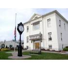
Ellington: ELLINGTON, CT - TOWN HALL
Ellington: Picture of Ellington
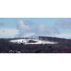
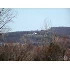
Ellington: Top View

Ellington: Driving along 83
Ellington: An old sign from a true marvel of Ellington's past.
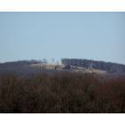
Ellington: Near Crystal Lake
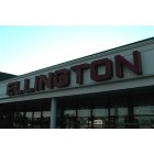
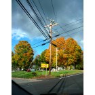
Ellington: Ellington, The best town to live
- add
your


Submit your own pictures of this town and show them to the world
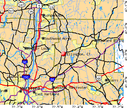
- OSM Map
- General Map
- Google Map
- MSN Map
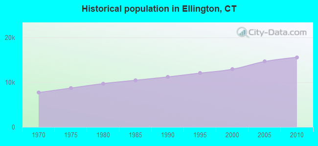
Population change since 2000: +20.7%
| Males: 7,686 | |
| Females: 7,916 |
| Median resident age: | 40.9 years |
| Connecticut median age: | 39.2 years |
Zip codes: 06029.
| Ellington: | $102,316 |
| CT: | $88,429 |
Estimated per capita income in 2022: $49,788 (it was $27,766 in 2000)
Ellington town income, earnings, and wages data
Estimated median house or condo value in 2022: $337,904 (it was $156,300 in 2000)
| Ellington: | $337,904 |
| CT: | $347,200 |
Mean prices in 2022: all housing units: $356,092; detached houses: $368,662; townhouses or other attached units: $222,514; in 2-unit structures: $281,599; in 3-to-4-unit structures: $156,197; in 5-or-more-unit structures: $146,539; mobile homes: $46,042
Detailed information about poverty and poor residents in Ellington, CT


- 14,10490.4%White alone
- 5163.3%Asian alone
- 4062.6%Hispanic
- 2831.8%Black alone
- 2371.5%Two or more races
- 250.2%American Indian alone
- 290.2%Other race alone
- 20.01%Native Hawaiian and Other
Pacific Islander alone
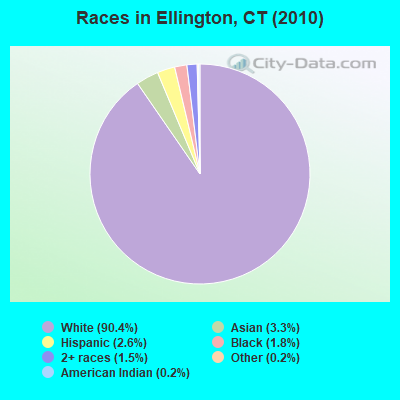
Races in Ellington detailed stats: ancestries, foreign born residents, place of birth
According to our research of Connecticut and other state lists, there were 10 registered sex offenders living in Ellington, Connecticut as of April 26, 2024.
The ratio of all residents to sex offenders in Ellington is 1,560 to 1.
The ratio of registered sex offenders to all residents in this city is lower than the state average.
 Recent articles from our blog. Our writers, many of them Ph.D. graduates or candidates, create easy-to-read articles on a wide variety of topics.


 | 2024 Connecticut Town Tournament VI (Celebrating the 10-Year Anniversary & Dazzleman's Memorial) (705 replies) |
| Daylight Savings Time in CT? (149 replies) |
| Connecticut TOWN TOURNAMENT V (2022) (831 replies) |
| Connecticut TOWN TOURNAMENT IV (2020) (849 replies) |
| Public schools on CT shoreline with great special ed services (23 replies) |
| CT Best School Districts Special Needs/ Special Ed (17 replies) |
Latest news from Ellington, CT collected exclusively by city-data.com from local newspapers, TV, and radio stations
Ellington, CT City Guides:
Ancestries: Irish (21.0%), German (15.9%), Italian (15.3%), French (14.0%), English (12.5%), Polish (11.8%).
Current Local Time: EST time zone
Incorporated on 05/1786
Elevation: 240 feet
Land area: 34.1 square miles.
Population density: 458 people per square mile (low).
467 residents are foreign born (1.4% Europe, 1.1% Asia, 0.6% North America).
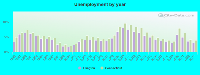
| This town: | 3.6% |
| Connecticut: | 10.9% |
| Ellington town: | 2.0% ($3,095) |
| Connecticut: | 1.8% ($2,961) |
Nearest city with pop. 50,000+: Manchester, CT  (9.9 miles , pop. 54,740).
Nearest city with pop. 200,000+: Boston, MA (75.3 miles , pop. 589,141).
Nearest city with pop. 1,000,000+: Bronx, NY (104.4 miles , pop. 1,332,650).
Nearest cities:
), ), Latitude: 41.91 N, Longitude: 72.45 W
Area code commonly used in this area: 860

Ellington, Connecticut accommodation & food services, waste management - Economy and Business Data
Single-family new house construction building permits:
- 2022: 17 buildings, average cost: $251,300
- 2021: 48 buildings, average cost: $210,500
- 2020: 39 buildings, average cost: $210,500
- 2019: 37 buildings, average cost: $210,500
- 2018: 42 buildings, average cost: $210,500
- 2017: 42 buildings, average cost: $210,600
- 2016: 40 buildings, average cost: $210,500
- 2015: 41 buildings, average cost: $210,600
- 2014: 44 buildings, average cost: $210,200
- 2013: 40 buildings, average cost: $212,100
- 2012: 36 buildings, average cost: $214,000
- 2011: 28 buildings, average cost: $229,100
- 2010: 27 buildings, average cost: $246,100
- 2009: 32 buildings, average cost: $230,000
- 2008: 47 buildings, average cost: $203,700
- 2007: 71 buildings, average cost: $260,700
- 2006: 96 buildings, average cost: $238,700
- 2005: 90 buildings, average cost: $273,800
- 2004: 74 buildings, average cost: $258,100
- 2003: 122 buildings, average cost: $171,200
- 2002: 111 buildings, average cost: $177,900
- 2001: 84 buildings, average cost: $173,600
- 2000: 129 buildings, average cost: $168,000
- 1999: 94 buildings, average cost: $159,600
- 1998: 50 buildings, average cost: $160,700
- 1997: 59 buildings, average cost: $159,300
| Here: | 3.1% |
| Connecticut: | 3.9% |
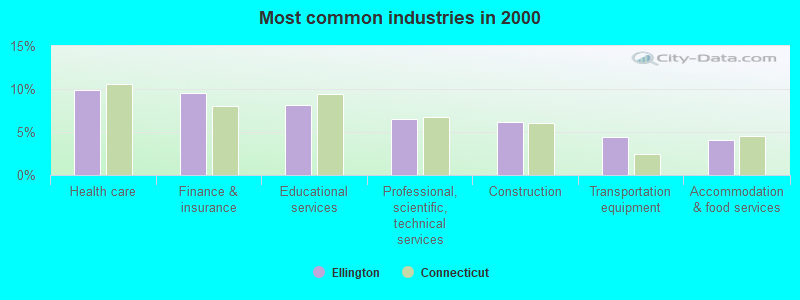
- Health care (9.9%)
- Finance & insurance (9.5%)
- Educational services (8.1%)
- Professional, scientific, technical services (6.5%)
- Construction (6.2%)
- Transportation equipment (4.4%)
- Accommodation & food services (4.0%)
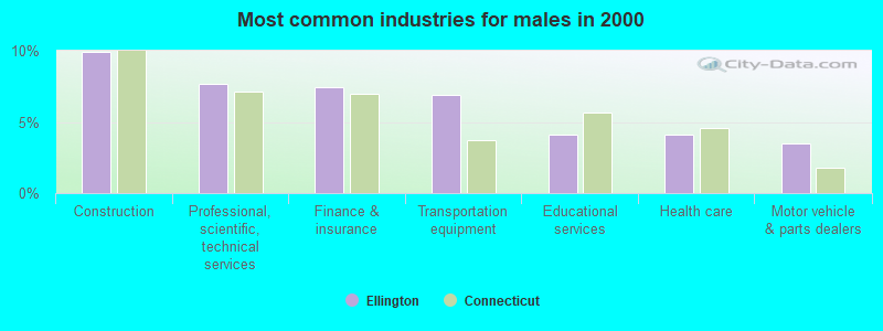
- Construction (9.9%)
- Professional, scientific, technical services (7.6%)
- Finance & insurance (7.4%)
- Transportation equipment (6.9%)
- Educational services (4.1%)
- Health care (4.1%)
- Motor vehicle & parts dealers (3.5%)
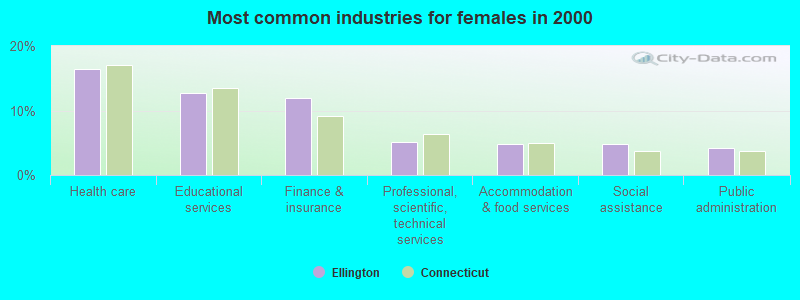
- Health care (16.4%)
- Educational services (12.6%)
- Finance & insurance (11.9%)
- Professional, scientific, technical services (5.1%)
- Accommodation & food services (4.8%)
- Social assistance (4.7%)
- Public administration (4.2%)
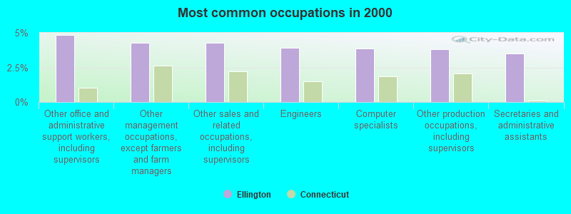
- Other office and administrative support workers, including supervisors (4.8%)
- Other management occupations, except farmers and farm managers (4.3%)
- Other sales and related occupations, including supervisors (4.3%)
- Engineers (3.9%)
- Computer specialists (3.9%)
- Other production occupations, including supervisors (3.8%)
- Secretaries and administrative assistants (3.5%)
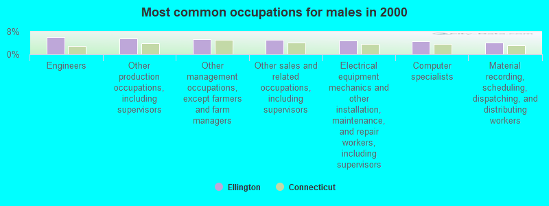
- Engineers (6.1%)
- Other production occupations, including supervisors (5.6%)
- Other management occupations, except farmers and farm managers (5.5%)
- Other sales and related occupations, including supervisors (5.2%)
- Electrical equipment mechanics and other installation, maintenance, and repair workers, including supervisors (4.9%)
- Computer specialists (4.5%)
- Material recording, scheduling, dispatching, and distributing workers (4.0%)
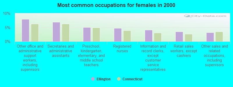
- Other office and administrative support workers, including supervisors (7.9%)
- Secretaries and administrative assistants (6.9%)
- Preschool, kindergarten, elementary, and middle school teachers (5.0%)
- Registered nurses (4.8%)
- Information and record clerks, except customer service representatives (4.1%)
- Retail sales workers, except cashiers (3.5%)
- Other sales and related occupations, including supervisors (3.2%)
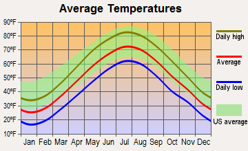
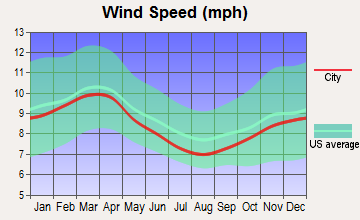
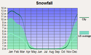
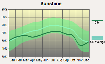
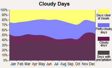
Average climate in Ellington, Connecticut
Based on data reported by over 4,000 weather stations
(lower is better)
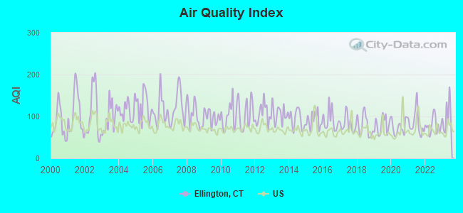
Air Quality Index (AQI) level in 2023 was 100. This is worse than average.
| City: | 100 |
| U.S.: | 73 |

Carbon Monoxide (CO) [ppm] level in 2022 was 0.312. This is worse than average. Closest monitor was 8.8 miles away from the city center.
| City: | 0.312 |
| U.S.: | 0.251 |
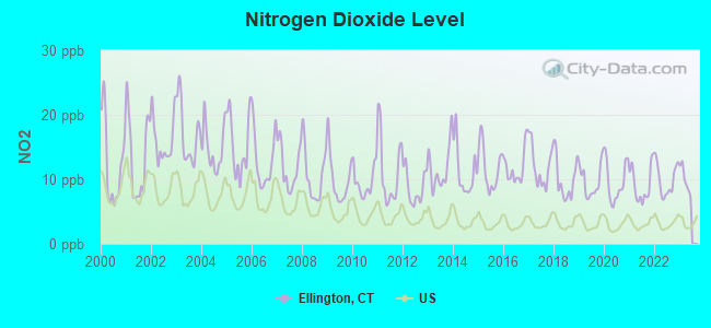
Nitrogen Dioxide (NO2) [ppb] level in 2022 was 9.94. This is significantly worse than average. Closest monitor was 5.5 miles away from the city center.
| City: | 9.94 |
| U.S.: | 5.11 |
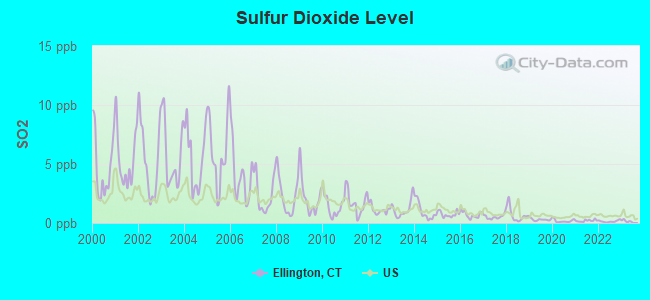
Sulfur Dioxide (SO2) [ppb] level in 2022 was 0.141. This is significantly better than average. Closest monitor was 8.1 miles away from the city center.
| City: | 0.141 |
| U.S.: | 1.515 |
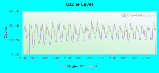
Ozone [ppb] level in 2023 was 34.7. This is about average. Closest monitor was 5.5 miles away from the city center.
| City: | 34.7 |
| U.S.: | 33.3 |
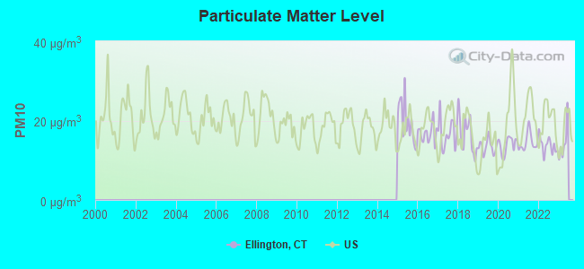
Particulate Matter (PM10) [µg/m3] level in 2022 was 13.7. This is better than average. Closest monitor was 8.1 miles away from the city center.
| City: | 13.7 |
| U.S.: | 19.2 |
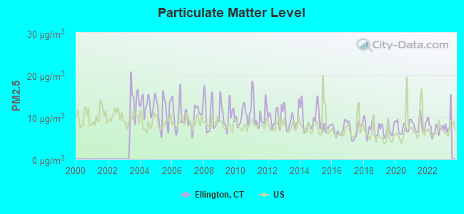
Particulate Matter (PM2.5) [µg/m3] level in 2022 was 7.23. This is about average. Closest monitor was 12.9 miles away from the city center.
| City: | 7.23 |
| U.S.: | 8.11 |
Tornado activity:
Ellington-area historical tornado activity is slightly above Connecticut state average. It is 15% smaller than the overall U.S. average.
On 10/3/1979, a category F4 (max. wind speeds 207-260 mph) tornado 11.6 miles away from the Ellington town center killed 3 people and injured 500 people and caused between $50,000,000 and $500,000,000 in damages.
On 5/10/1954, a category F3 (max. wind speeds 158-206 mph) tornado 1.3 miles away from the town center injured 2 people and caused between $5000 and $50,000 in damages.
Earthquake activity:
Ellington-area historical earthquake activity is significantly above Connecticut state average. It is 71% smaller than the overall U.S. average.On 10/7/1983 at 10:18:46, a magnitude 5.3 (5.1 MB, 5.3 LG, 5.1 ML, Class: Moderate, Intensity: VI - VII) earthquake occurred 170.7 miles away from the city center
On 4/20/2002 at 10:50:47, a magnitude 5.3 (5.3 ML, Depth: 3.0 mi) earthquake occurred 190.6 miles away from the city center
On 4/20/2002 at 10:50:47, a magnitude 5.2 (5.2 MB, 4.2 MS, 5.2 MW, 5.0 MW) earthquake occurred 189.3 miles away from the city center
On 1/19/1982 at 00:14:42, a magnitude 4.7 (4.5 MB, 4.7 MD, 4.5 LG, Class: Light, Intensity: IV - V) earthquake occurred 118.1 miles away from the city center
On 10/16/2012 at 23:12:25, a magnitude 4.7 (4.7 ML, Depth: 10.0 mi) earthquake occurred 147.9 miles away from the city center
On 8/23/2011 at 17:51:04, a magnitude 5.8 (5.8 MW, Depth: 3.7 mi) earthquake occurred 401.6 miles away from Ellington center
Magnitude types: regional Lg-wave magnitude (LG), body-wave magnitude (MB), duration magnitude (MD), local magnitude (ML), surface-wave magnitude (MS), moment magnitude (MW)
Natural disasters:
The number of natural disasters in Tolland County (24) is greater than the US average (15).Major Disasters (Presidential) Declared: 13
Emergencies Declared: 11
Causes of natural disasters: Hurricanes: 6, Snowstorms: 5, Storms: 5, Blizzards: 3, Floods: 3, Snows: 3, Winter Storms: 3, Snowfall: 1, Tropical Storm: 1, Wind: 1, Other: 1 (Note: some incidents may be assigned to more than one category).

Hospitals and medical centers near Ellington:
- ROCKVILLE GENERAL HOSPITAL Acute Care Hospitals (about 4 miles away; ROCKVILLE, CT)
- WOODLAKE AT TOLLAND (Nursing Home, about 4 miles away; TOLLAND, CT)
- VERNON MANOR HEALTH CARE CENTER (Nursing Home, about 5 miles away; VERNON, CT)
- T R I-COUNTY ARC: DUNN HILL (Hospital, about 5 miles away; TOLLAND, CT)
- VISITING NURSE AND HEALTH SERVICES OF CONNECTICUT (Home Health Center, about 6 miles away; VERNON, CT)
- VISITING NURSE AND HEALTH SERVIC (Hospital, about 6 miles away; VERNON, CT)
- EVERGREEN HEALTH CARE CENTER (Nursing Home, about 6 miles away; STAFFORD SPRINGS, CT)
Airports and heliports located in Ellington:
- Ellington Airport (7B9) (Runways: 1, Air Taxi Ops: 20, Itinerant Ops: 300, Local Ops: 26,800)
- Wysocki Field Airport (CT15) (Runways: 1)
- Strangers Point Heliport (02CT)
Amtrak stations near Ellington:
- 10 miles: WINDSOR LOCKS (S. MAIN ST. (RTE. 159)) . Services: public payphones, free short-term parking, free long-term parking, call for car rental service, call for taxi service, public transit connection.
- 11 miles: WINDSOR (41 CENTRAL ST.) . Services: enclosed waiting area, public restrooms, public payphones, free short-term parking, call for car rental service, call for taxi service, public transit connection.
- 16 miles: SPRINGFIELD (66 LYMAN ST.) . Services: ticket office, partially wheelchair accessible, enclosed waiting area, public restrooms, public payphones, full-service food facilities, snack bar, vending machines, ATM, paid short-term parking, paid long-term parking, call for car rental service, taxi stand, intercity bus service, public transit connection.
Colleges/universities with over 2000 students nearest to Ellington:
- Manchester Community College (about 12 miles; Manchester, CT; Full-time enrollment: 4,667)
- Bay Path College (about 13 miles; Longmeadow, MA; FT enrollment: 2,085)
- University of Connecticut (about 13 miles; Storrs, CT; FT enrollment: 22,037)
- Springfield College (about 15 miles; Springfield, MA; FT enrollment: 3,144)
- Western New England University (about 15 miles; Springfield, MA; FT enrollment: 3,477)
- American International College (about 16 miles; Springfield, MA; FT enrollment: 2,733)
- Capital Community College (about 16 miles; Hartford, CT; FT enrollment: 2,609)
Public high school in Ellington:
- ELLINGTON HIGH SCHOOL (Students: 526, Location: 37 MAPLE STREET, Grades: 9-12)
Public elementary/middle schools in Ellington:
- WINDERMERE SCHOOL (Students: 841, Location: 2 ABBOTT ROAD, Grades: KG-4)
- ELLINGTON MIDDLE SCHOOL (Students: 404, Location: 46 MIDDLE BUTCHER ROAD, Grades: 7-8)
- CRYSTAL LAKE SCHOOL (Students: 210, Location: 284 SANDY BEACH ROAD, Grades: KG-4)
- CENTER SCHOOL (Location: 49 MAIN STREET, Grades: PK-4)
- WINDERMERE INTERMEDIATE SCHOOL (Location: 2 ABBOTT ROAD, Grades: 5-6)
Points of interest:
Notable locations in Ellington: Sadds Mill (A), Ellington Fire Marshal's Office (B), Ellington Volunteer Fire Department (C), Crystal Lake Volunteer Fire Department (D), Ellington Volunteer Ambulance Corps (E). Display/hide their locations on the map
Cemeteries: Charter Cemetery (1), Crystal Lake Cemetery (2). Display/hide their locations on the map
Lakes and reservoirs: Thompson Pond (A), Bradleys Pond (B), Creamery Pond (C), Sadds Mill Pond (D), Charters Pond (E), Crystal Lake (F). Display/hide their locations on the map
Streams, rivers, and creeks: Marsh Brook (A), Muddy Brook (B), Pinney Brook (C), Aborn Brook (D), Bahlers Brook (E), Belding Brook (F), Bradleys Brook (G), Creamery Brook (H), Davis Brook (I). Display/hide their locations on the map
Tourist attractions: Fielding Family Amusements LLC (Amusement & Theme Parks; 90 West Road) (1), Ireland Tours (Tours & Charters; 18 Cindy Road) (2). Display/hide their approximate locations on the map
Birthplace of: Echo Chernik - Illustrator, John H. Brockway - Politician, Meriva M. Carpenter - Artist, Orlow W. Chapman - Politician.
| This town: | 2.5 people |
| Connecticut: | 2.5 people |
| This town: | 67.0% |
| Whole state: | 66.3% |
| This town: | 6.6% |
| Whole state: | 6.6% |
Likely homosexual households (counted as self-reported same-sex unmarried-partner households)
- Lesbian couples: 0.5% of all households
- Gay men: 0.4% of all households
| This town: | 3.6% |
| Whole state: | 7.9% |
| This town: | 1.2% |
| Whole state: | 3.9% |
People in group quarters in Ellington in 2010:
- 8 people in group homes intended for adults
- 6 people in residential treatment centers for adults
- 6 people in workers' group living quarters and job corps centers
- 3 people in other noninstitutional facilities
People in group quarters in Ellington in 2000:
- 20 people in homes for the mentally retarded
- 5 people in religious group quarters
- 3 people in homes for the mentally ill
Banks with branches in Ellington (2011 data):
- First Niagara Bank, National Association: Ellington Branch at 175 West Road, branch established on 1974/06/18. Info updated 2011/06/09: Bank assets: $32,750.6 mil, Deposits: $19,595.4 mil, headquarters in Buffalo, NY, positive income, Commercial Lending Specialization, 351 total offices, Holding Company: First Niagara Financial Group, Inc.
- NEW ENGLAND BANK: Somers Road Branch at 287 Somers Road, branch established on 2006/04/15. Info updated 2009/06/12: Bank assets: $724.5 mil, Deposits: $582.4 mil, headquarters in Enfield, CT, positive income, Commercial Lending Specialization, 15 total offices, Holding Company: New England Bancshares, Inc.
- Rockville Bank: Ellington Branch at 12 Main Street, branch established on 1988/02/01. Info updated 2011/12/05: Bank assets: $1,748.3 mil, Deposits: $1,413.1 mil, headquarters in Vernon Rockville, CT, positive income, Commercial Lending Specialization, 22 total offices, Holding Company: Rockville Financial, Inc.
For population 15 years and over in Ellington:
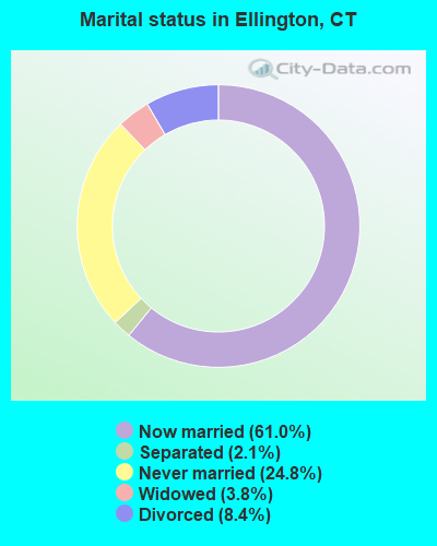
- Never married: 24.8%
- Now married: 61.0%
- Separated: 2.1%
- Widowed: 3.8%
- Divorced: 8.4%
For population 25 years and over in Ellington:
- High school or higher: 91.8%
- Bachelor's degree or higher: 32.1%
- Graduate or professional degree: 11.9%
- Unemployed: 3.0%
- Mean travel time to work (commute): 26.7 minutes
| Here: | 10.2 |
| Connecticut average: | 12.8 |
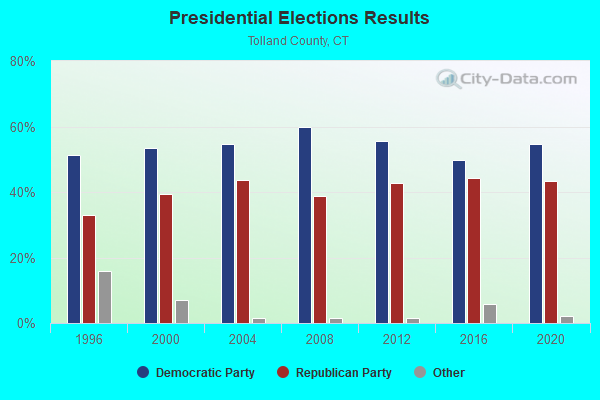
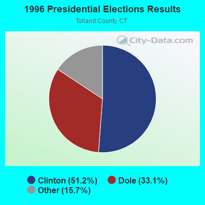
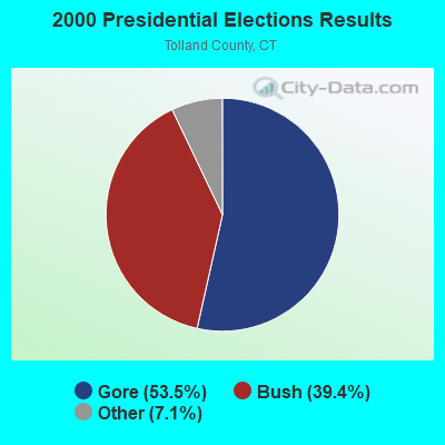
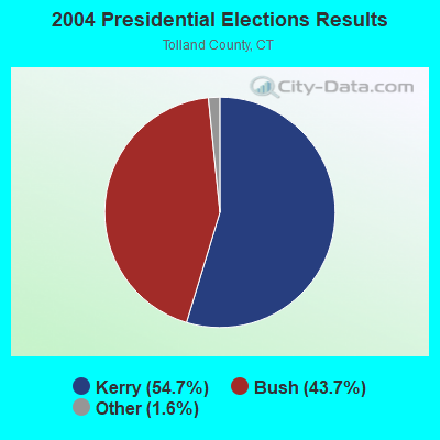
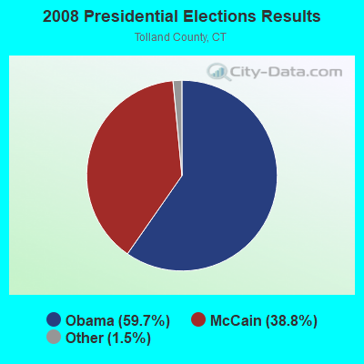
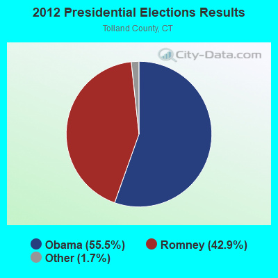
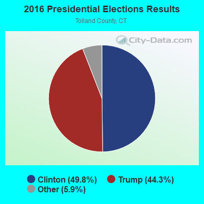
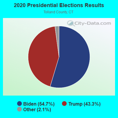
Graphs represent county-level data. Detailed 2008 Election Results
Religion statistics for Ellington, CT (based on Tolland County data)
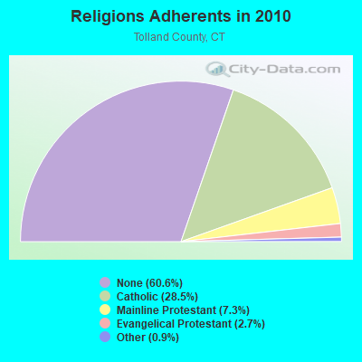
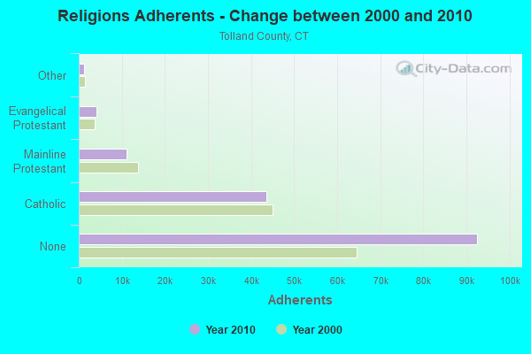
| Religion | Adherents | Congregations |
|---|---|---|
| Catholic | 43,500 | 14 |
| Mainline Protestant | 11,178 | 38 |
| Evangelical Protestant | 4,069 | 27 |
| Other | 1,302 | 8 |
| Orthodox | 100 | 1 |
| None | 92,542 | - |
Food Environment Statistics:
| Here: | 1.36 / 10,000 pop. |
| Connecticut: | 2.21 / 10,000 pop. |
| This county: | 1.15 / 10,000 pop. |
| State: | 1.02 / 10,000 pop. |
| Tolland County: | 2.24 / 10,000 pop. |
| State: | 2.27 / 10,000 pop. |
| Here: | 6.57 / 10,000 pop. |
| Connecticut: | 9.19 / 10,000 pop. |
| This county: | 6.2% |
| Connecticut: | 7.3% |
| This county: | 21.1% |
| Connecticut: | 21.5% |
| Here: | 12.9% |
| Connecticut: | 15.8% |
| Businesses in Ellington, CT | ||||
| Name | Count | Name | Count | |
|---|---|---|---|---|
| MasterBrand Cabinets | 3 | U-Haul | 1 | |
| McDonald's | 1 | YMCA | 1 | |
Strongest AM radio stations in Ellington:
- WNNZ (640 AM; 50 kW; WESTFIELD, MA; Owner: CLEAR CHANNEL BROADCASTING LICENSES, INC.)
- WTIC (1080 AM; 50 kW; HARTFORD, CT; Owner: INFINITY RADIO OPERATIONS INC.)
- WCTF (1170 AM; daytime; 1 kW; VERNON, CT; Owner: FAMILY STATIONS, INC.)
- WCRN (830 AM; 50 kW; WORCESTER, MA; Owner: CARTER BROADCASTING CORPORATION)
- WVNE (760 AM; daytime; 25 kW; LEICESTER, MA; Owner: BLOUNT MASSCOM, INC.)
- WALE (990 AM; 50 kW; GREENVILLE, RI; Owner: NORTH AMERICAN BROADCASTING CO., INC.)
- WDRC (1360 AM; 5 kW; HARTFORD, CT; Owner: BUCKLEY BROADCASTING CORPORATION)
- WACE (730 AM; 5 kW; CHICOPEE, MA; Owner: CARTER BROADCASTING CORP.)
- WHYN (560 AM; 5 kW; SPRINGFIELD, MA; Owner: CLEAR CHANNEL BROADCASTING LICENSES, INC.)
- WSPR (1270 AM; 5 kW; SPRINGFIELD, MA; Owner: ANTONIO F. AND HELENA R. GOIS, TENANTS BY THE ENTIRETY)
- WDZK (1550 AM; 5 kW; BLOOMFIELD, CT; Owner: ABC, INC.)
- WEEI (850 AM; 50 kW; BOSTON, MA; Owner: ENTERCOM BOSTON LICENSE, LLC)
- WRKO (680 AM; 50 kW; BOSTON, MA; Owner: ENTERCOM BOSTON LICENSE, LLC)
Strongest FM radio stations in Ellington:
- WHUS (91.7 FM; STORRS, CT; Owner: THE BD. OF TRUSTEES, THE UNIV. OF CT)
- WRCH (100.5 FM; NEW BRITAIN, CT; Owner: INFINITY RADIO OPERATIONS INC.)
- WAQY (102.1 FM; SPRINGFIELD, MA; Owner: SAGA COMMUNICATIONS OF NEW ENGLAND, LLC)
- WTIC-FM (96.5 FM; HARTFORD, CT; Owner: INFINITY RADIO OPERATIONS INC.)
- WWUH (91.3 FM; WEST HARTFORD, CT; Owner: UNIVERSITY OF HARTFORD)
- WCCC-FM (106.9 FM; HARTFORD, CT; Owner: MARLIN BROADCASTING, LLC)
- WHYN-FM (93.1 FM; SPRINGFIELD, MA; Owner: CLEAR CHANNEL BROADCASTING LICENSES, INC.)
- W258AC (99.5 FM; STORRS, CT; Owner: CONNECTICUT PUBLIC BROADCASTING, INC)
- WRNX (100.9 FM; AMHERST, MA; Owner: WESTERN MASSACHUSETTS RADIO COMPANY)
- WPKX (97.9 FM; ENFIELD, CT; Owner: CAPSTAR TX LIMITED PARTNERSHIP)
- WILI-FM (98.3 FM; WILLIMANTIC, CT; Owner: NUTMEG BROADCASTING COMPANY)
- WFCR (88.5 FM; AMHERST, MA; Owner: UNIVERSITY OF MASSACHUSETTS)
- WWYZ (92.5 FM; WATERBURY, CT; Owner: CAPSTAR TX LIMITED PARTNERSHIP)
- WKSS (95.7 FM; HARTFORD-MERIDEN, CT; Owner: CAPSTAR TX LIMITED PARTNERSHIP)
- WZMX (93.7 FM; HARTFORD, CT; Owner: INFINITY RADIO OPERATIONS INC.)
- WHCN (105.9 FM; HARTFORD, CT; Owner: CAPSTAR TX LIMITED PARTNERSHIP)
- WMRQ (104.1 FM; WATERBURY, CT; Owner: CAPSTAR TX LIMITED PARTNERSHIP)
- WAAF (107.3 FM; WORCESTER, MA; Owner: ENTERCOM BOSTON LICENSE, LLC)
- WPKT (90.5 FM; MERIDEN, CT; Owner: CONNECTICUT PUBLIC BROADCASTING, INC)
- WDRC-FM (102.9 FM; HARTFORD, CT; Owner: BUCKLEY BROADCASTING CORPORATION)
TV broadcast stations around Ellington:
- WTIC-TV (Channel 61; HARTFORD, CT; Owner: TRIBUNE TELEVISION COMPANY)
- W11BJ (Channel 11; HARTFORD, CT; Owner: COMMUNICATIONS SITE MANAGEMENT LLC)
- WYDN (Channel 48; WORCESTER, MA; Owner: EDUCATIONAL PUBLIC TV CORPORATION)
- WUVN (Channel 18; HARTFORD, CT; Owner: ENTRAVISION HOLDINGS, LLC)
- WTXX (Channel 20; WATERBURY, CT; Owner: WTXX INC.)
- WVIT (Channel 30; NEW BRITAIN, CT; Owner: OUTLET BROADCASTING, INC)
- WEDH (Channel 24; HARTFORD, CT; Owner: CONNECTICUT PUBLIC BROADCASTING, INC.)
- WFSB (Channel 3; HARTFORD, CT; Owner: MEREDITH CORPORATION)
- WWLP (Channel 22; SPRINGFIELD, MA; Owner: WWLP BROADCASTING, LLC)
- WHPX (Channel 26; NEW LONDON, CT; Owner: PAXSON HARTFORD LICENSE, INC.)
- WHTX-LP (Channel 10; HARTFORD, CT; Owner: ENTRAVISION HOLDINGS, LLC)
- WPXQ (Channel 69; BLOCK ISLAND, RI; Owner: OCEAN STATE TELEVISION, L.L.C.)
- WRDM-LP (Channel 13; HARTFORD, CT; Owner: ZGS HARTFORD, INC.)
- WMLD-LP (Channel 6; HARTFORD, CT; Owner: HARVARD BROADCASTING, INC.)
- WUNI (Channel 27; WORCESTER, MA; Owner: ENTRAVISION HOLDINGS, LLC)
- WHCT-LP (Channel 38; HARTFORD, CT; Owner: VENTURE TECHNOLOGIES GROUP, LLC)
- W67DF (Channel 67; SPRINGFIELD, MA; Owner: TRINITY BROADCASTING NETWORK)
- WDMR-LP (Channel 65; SPRINGFIELD, MA; Owner: ZGS HARTFORD, INC.)
- W12CL (Channel 12; GRANBY, CT; Owner: SALVATORE MINNITI)
- National Bridge Inventory (NBI) Statistics
- 12Number of bridges
- 49ft / 14.6mTotal length
- $2,600,000Total costs
- 54,763Total average daily traffic
- 2,269Total average daily truck traffic
- 81,373Total future (year 2035) average daily traffic
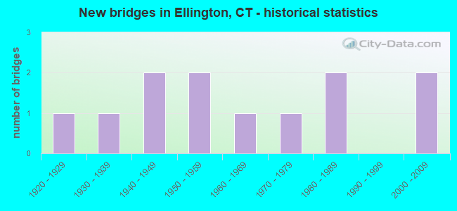
- New bridges - historical statistics
- 11920-1929
- 11930-1939
- 21940-1949
- 21950-1959
- 11960-1969
- 11970-1979
- 21980-1989
- 22000-2009
FCC Registered Broadcast Land Mobile Towers:
4- Lat: 41.415139 Lon: -72.393889, Call Sign: WQCT263,
Assigned Frequencies: 462.437 MHz, 463.437 MHz, 467.387 MHz, 467.412 MHz, 467.437 MHz, 462.237 MHz, Grant Date: 05/19/2015, Expiration Date: 05/18/2025, Certifier: Rod Maclean, Registrant: Utility Communications Inc, 920 Sherman Avenue, Hamden, CT 06514, Phone: (203) 287-1306, Fax: (203) 248-9167, Email:
- 151 Crystal Lake Rd (Lat: 41.919889 Lon: -72.418583), Call Sign: WQKZ977,
Assigned Frequencies: 462.287 MHz, 467.287 MHz, 451.662 MHz, 456.662 MHz, Grant Date: 11/09/2009, Expiration Date: 11/09/2019, Cancellation Date: 01/11/2020, Certifier: Joseph M Ravalese, Registrant: Utility Communications, Inc., 920 Sherman Ave, Hamden, CT 06514, Phone: (201) 287-1306, Fax: (203) 248-9167, Email:
- Lat: 41.915417 Lon: -72.493028, Call Sign: WQQZ273,
Assigned Frequencies: 451.412 MHz, 456.412 MHz, 451.562 MHz, 456.562 MHz, Grant Date: 03/28/2013, Expiration Date: 03/28/2023, Cancellation Date: 06/03/2023, Certifier: Greg Gale, Registrant: Cara Enterprises Inc, Las Vegas, NV 89140-0124, Phone: (702) 838-9728, Fax: (702) 363-4607, Email:
- Lat: 41.930694 Lon: -72.378500, Call Sign: WQVU846,
Assigned Frequencies: 72.4000 MHz, Grant Date: 05/15/2015, Expiration Date: 05/15/2025, Certifier: Robert Butler, Registrant: Primex Wireless Inc, 965 Wells St., Lake Geneva, WI 53147, Phone: (800) 537-0464
FCC Registered Microwave Towers:
1- SOAPSTONE MT, Soapstone Mtn Shenipsit State Park (Lat: 41.958694 Lon: -72.413417), Type: Ltower, Structure height: 25.6 m, Call Sign: WPNB752,
Assigned Frequencies: 6565.00 MHz, 5974.85 MHz, Grant Date: 09/14/2021, Expiration Date: 12/03/2031, Registrant: State Of Connecticut, 1111 Country Club Rd, Middletown, CT 06457, Phone: (860) 685-8080, Fax: (860) 685-8362, Email:
FCC Registered Maritime Coast & Aviation Ground Towers:
1- Ellington Airport (Lat: 41.933417 Lon: -72.466194), Type: Building, Overall height: 10 m, Call Sign: KCD2,
Assigned Frequencies: 123.000 MHz, Grant Date: 06/03/2009, Expiration Date: 06/08/2019, Cancellation Date: 08/10/2019, Registrant: Northeast Helicopters, 360 Somers Road, Ellington, CT 06029, Phone: (860) 871-2054, Fax: (860) 875-2861, Email:
FCC Registered Amateur Radio Licenses:
107 (See the full list of FCC Registered Amateur Radio Licenses in Ellington)FAA Registered Aircraft Manufacturers and Dealers:
3 (See the full list of FAA Registered Manufacturers and Dealers in Ellington)FAA Registered Aircraft:
19 (See the full list of FAA Registered Aircraft)2002 - 2018 National Fire Incident Reporting System (NFIRS) incidents
- Fire incident types reported to NFIRS in Ellington, CT
- 30249.3%Structure Fires
- 21034.3%Outside Fires
- 7912.9%Mobile Property/Vehicle Fires
- 213.4%Other
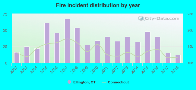 According to the data from the years 2002 - 2018 the average number of fires per year is 36. The highest number of reported fires - 67 took place in 2007, and the least - 12 in 2018. The data has a dropping trend.
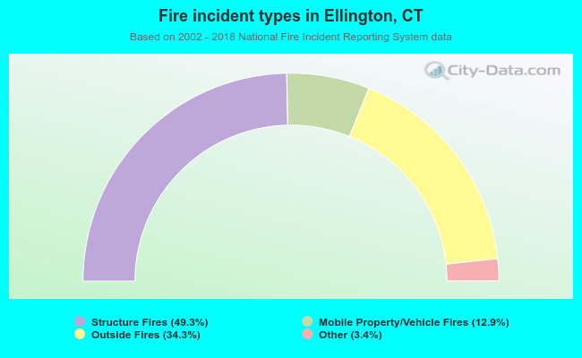 When looking into fire subcategories, the most incidents belonged to: Structure Fires (49.3%), and Outside Fires (34.3%).
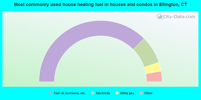
- 75.0%Fuel oil, kerosene, etc.
- 14.7%Electricity
- 4.8%Utility gas
- 2.5%Bottled, tank, or LP gas
- 2.1%Wood
- 0.6%Other fuel
- 0.3%Coal or coke
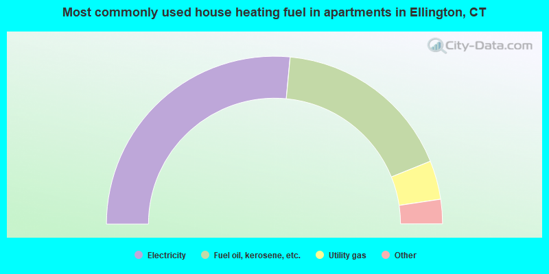
- 53.0%Electricity
- 34.8%Fuel oil, kerosene, etc.
- 7.5%Utility gas
- 3.8%Bottled, tank, or LP gas
- 1.0%Other fuel
Ellington compared to Connecticut state average:
- Unemployed percentage significantly below state average.
- Black race population percentage significantly below state average.
- Hispanic race population percentage significantly below state average.
- Foreign-born population percentage significantly below state average.
- Length of stay since moving in significantly above state average.
- Number of rooms per house significantly below state average.
- House age significantly below state average.
Ellington on our top lists:
- #20 on the list of "Top 101 cities with largest percentage of females in industries: fuel dealers (population 5,000+)"
- #20 on the list of "Top 101 cities with largest percentage of females in industries: motor vehicle and parts dealers (population 5,000+)"
- #28 on the list of "Top 101 cities with largest percentage of females in industries: data processing, libraries, and other information services (population 5,000+)"
- #30 on the list of "Top 101 cities with largest percentage of females in occupations: engineers (population 5,000+)"
- #33 on the list of "Top 101 cities with largest percentage of females in industries: petroleum and coal products (population 5,000+)"
- #62 on the list of "Top 101 cities with largest percentage of males in industries: printing and related support activities (population 5,000+)"
- #63 on the list of "Top 101 cities with largest percentage of females in occupations: judges, magistrates, and other judicial workers (population 5,000+)"
- #65 on the list of "Top 101 cities with largest percentage of males in occupations: occupational and physical therapist assistants and aides (population 5,000+)"
- #72 on the list of "Top 101 cities with largest percentage of females in occupations: physicians and surgeons (population 5,000+)"
- #75 on the list of "Top 101 cities with largest percentage of females in industries: electronic shopping and mail-order houses (population 5,000+)"
- #75 on the list of "Top 101 cities with largest percentage of males in industries: lumber and other construction materials merchant wholesalers (population 5,000+)"
- #84 on the list of "Top 101 cities with largest percentage of males in occupations: engineers (population 5,000+)"
- #84 on the list of "Top 101 cities with the most residents born in United Kingdom (population 500+)"
- #84 on the list of "Top 101 cities with the most residents born in Yugoslavia (population 500+)"
- #84 on the list of "Top 101 cities with the most residents born in Asia, n.e.c. (population 500+)"
- #84 on the list of "Top 101 cities with the most residents born in Melanesia (population 500+)"
- #84 on the list of "Top 101 cities with the most residents born in Micronesia (population 500+)"
- #84 on the list of "Top 101 cities with the most residents born in Polynesia (population 500+)"
- #94 on the list of "Top 101 cities with largest percentage of males in occupations: secretaries and administrative assistants (population 5,000+)"
- #97 (06029) on the list of "Top 101 zip codes with the largest percentage of Swiss first ancestries (pop 5,000+)"
- #8 on the list of "Top 101 counties with the lowest number of births per 1000 residents 2007-2013"
- #10 on the list of "Top 101 counties with the largest decrease in the number of births per 1000 residents 2000-2006 to 2007-2013 (pop 50,000+)"
- #19 on the list of "Top 101 counties with the best general health status score of residents (1-5), 3 years of data"
- #21 on the list of "Top 101 counties with the highest percentage of residents that visited a dentist within the past year"
- #44 on the list of "Top 101 counties with the highest percentage of residents that exercised in the past month"

|
|
Total of 496 patent applications in 2008-2024.