North Hampton, New Hampshire
Submit your own pictures of this town and show them to the world
- OSM Map
- General Map
- Google Map
- MSN Map
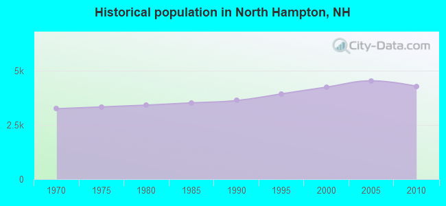
Population change since 2000: +1.0%
 |
| Males: 2,102 | |
| Females: 2,199 |
| Median resident age: | 47.9 years |
| New Hampshire median age: | 43.9 years |
Zip codes: 03862.
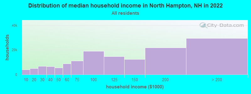
| North Hampton: | $123,232 |
| NH: | $89,992 |
Estimated per capita income in 2022: $75,044 (it was $34,187 in 2000)
North Hampton town income, earnings, and wages data
Estimated median house or condo value in 2022: $590,646 (it was $193,300 in 2000)
| North Hampton: | $590,646 |
| NH: | $384,700 |
Mean prices in 2022: all housing units: $614,227; detached houses: $665,470; townhouses or other attached units: $408,866; in 2-unit structures: $730,084; in 3-to-4-unit structures: over $1,000,000; in 5-or-more-unit structures: $329,099; mobile homes: $126,160
Detailed information about poverty and poor residents in North Hampton, NH

Compare current foreclosures near North Hampton, NH:
| Photo | Address | Area | Beds / Baths | Price | Details |
|---|---|---|---|---|---|

|
#1
Beach Rose Ln
North Hampton, NH 03862
|
- sq. feet
|
- baths - beds |
show details | |

|
#2
Juniper Rd
North Hampton, NH 03862
|
- sq. feet
|
- baths - beds |
show details | |

|
#3
Brentwood Rd
Exeter, NH 03833
|
2,756 sq. feet
|
2 baths 3 beds |
$419,900
|
show details |

|
#4
Beede Hill Rd
Fremont, NH 03044
|
1,135 sq. feet
|
1 baths 3 beds |
show details | |

|
#5
Williamine Dr
Newton, NH 03858
|
2,295 sq. feet
|
1 baths 3 beds |
show details | |

|
#6
Windbrook Dr
Epping, NH 03042
|
1,680 sq. feet
|
1 baths 3 beds |
show details | |

|
#7
Lincoln Ave
Newmarket, NH 03857
|
1,568 sq. feet
|
3 baths 3 beds |
show details | |

|
#8
Smoke St
Nottingham, NH 03290
|
2,681 sq. feet
|
2 baths 3 beds |
show details | |

|
#9
Senee Ct
Amesbury, MA 01913
|
1,190 sq. feet
|
1 baths 3 beds |
show details | |

|
#10
Aubin St # 1
Amesbury, MA 01913
|
1,230 sq. feet
|
2 baths 4 beds |
show details |
| Photo | Address | Area | Beds / Baths | Price | Details |
|---|---|---|---|---|---|

|
#11
64th St
Newburyport, MA 01950
|
1,517 sq. feet
|
2 baths 2 beds |
show details | |

|
#12
Main Ave
East Kingston, NH 03827
|
1,982 sq. feet
|
1 baths 3 beds |
show details | |

|
#13
Wentworth Ter
Dover, NH 03820
|
2,404 sq. feet
|
3 baths 6 beds |
show details | |

|
#14
Dock Ln
Salisbury, MA 01952
|
1,667 sq. feet
|
2 baths 3 beds |
show details | |

|
#15
Maple St
Amesbury, MA 01913
|
2,186 sq. feet
|
2 baths 4 beds |
show details | |

|
#16
Main St Apt 4
Amesbury, MA 01913
|
645 sq. feet
|
1 baths 1 beds |
show details | |

|
#17
Cedar Point Rd
Durham, NH 03824
|
4,052 sq. feet
|
3 baths 3 beds |
show details | |

|
#18
Lake St
Amesbury, MA 01913
|
2,650 sq. feet
|
2 baths 4 beds |
show details | |

|
#19
Merrill Ave
Amesbury, MA 01913
|
1,467 sq. feet
|
1 baths 3 beds |
show details | |

|
#20
Gove Dr
Newburyport, MA 01950
|
3,044 sq. feet
|
3 baths 3 beds |
show details |
| Photo | Address | Area | Beds / Baths | Price | Details |
|---|---|---|---|---|---|

|
#21
Kimball Rd
Amesbury, MA 01913
|
1,792 sq. feet
|
1 baths 3 beds |
show details | |

|
#22
Storey Ave Apt 2
Newburyport, MA 01950
|
708 sq. feet
|
1 baths 2 beds |
show details | |

|
#23
Munroe St
Newburyport, MA 01950
|
1,815 sq. feet
|
2 baths 3 beds |
show details | |

|
#24
Middle Rd
Dover, NH 03820
|
1,120 sq. feet
|
1 baths 3 beds |
show details | |

|
#25
Northam Dr
Dover, NH 03820
|
1,999 sq. feet
|
2 baths 3 beds |
show details | |

|
#26
Old Post Rd
York, ME 03909
|
864 sq. feet
|
1 baths 2 beds |
show details | |

|
#27
Main St
West Newbury, MA 01985
|
2,934 sq. feet
|
2 baths 5 beds |
show details | |

|
#28
Chapel St
Dover, NH 03820
|
1,872 sq. feet
|
2 baths 4 beds |
show details | |

|
#29
Dearborn Rd
Epping, NH 03042
|
1,768 sq. feet
|
2 baths 3 beds |
show details | |

|
#30
Knights Ct
Newbury, MA 01951
|
4,057 sq. feet
|
3 baths 5 beds |
show details |
| Photo | Address | Area | Beds / Baths | Price | Details |
|---|---|---|---|---|---|

|
#31
Back River Rd
Dover, NH 03820
|
1,193 sq. feet
|
1 baths 3 beds |
show details | |

|
#32
Northern Blvd
Newburyport, MA 01950
|
805 sq. feet
|
1 baths 2 beds |
show details | |

|
#33
Frost Hill Rd, C O Gregory Jackman
Eliot, ME 03903
|
3,472 sq. feet
|
3 baths 4 beds |
show details | |

|
#34
Bear Hill Rd
Merrimac, MA 01860
|
1,304 sq. feet
|
1 baths 3 beds |
show details | |

|
#35
Market St
Newburyport, MA 01950
|
1,732 sq. feet
|
2 baths 3 beds |
show details | |

|
#36
Summer S B
Newburyport, MA 01950
|
1,078 sq. feet
|
1 baths 3 beds |
show details | |

|
#37
Summer St # B
Newburyport, MA 01950
|
1,078 sq. feet
|
1 baths 3 beds |
show details | |

|
#38
Piscassic St
Newmarket, NH 03857
|
1,608 sq. feet
|
2 baths 4 beds |
show details | |

|
#39
Elm St
Salisbury, MA 01952
|
1,800 sq. feet
|
2 baths 4 beds |
show details | |

|
#40
W Whitehall Rd
Amesbury, MA 01913
|
1,593 sq. feet
|
1 baths 3 beds |
show details |
| Photo | Address | Area | Beds / Baths | Price | Details |
|---|---|---|---|---|---|

|
#41
Langs Ln
Newmarket, NH 03857
|
2,466 sq. feet
|
2 baths 3 beds |
show details | |

|
#42
Brentwood Rd
Exeter, NH 03833
|
3,683 sq. feet
|
3 baths 4 beds |
show details | |

|
#43
Elmwood St
Amesbury, MA 01913
|
1,848 sq. feet
|
1 baths 3 beds |
show details | |

|
#44
Dearborn Ave
Hampton, NH 03842
|
1,708 sq. feet
|
1 baths 3 beds |
show details | |

|
#45
Whittier Meadows Dr
Amesbury, MA 01913
|
1,344 sq. feet
|
2 baths 2 beds |
show details | |

|
#46
Adams Park
Rye, NH 03870
|
1,008 sq. feet
|
2 baths 3 beds |
show details | |

|
#47
Brown Ave # 52
Amesbury, MA 01913
|
741 sq. feet
|
1 baths 2 beds |
show details | |

|
#48
Harvard St
Exeter, NH 03833
|
1,509 sq. feet
|
1 baths 3 beds |
show details | |

|
#49
Plum St
Exeter, NH 03833
|
924 sq. feet
|
1 baths 3 beds |
show details | |

|
Check over 1 million property listings on Foreclosure.com!
|
browse all offers | |||

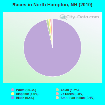
- 4,14296.3%White alone
- 551.3%Asian alone
- 411.0%Hispanic
- 350.8%Two or more races
- 190.4%Black alone
- 50.1%American Indian alone
- 30.07%Other race alone
- 10.02%Native Hawaiian and Other
Pacific Islander alone
Races in North Hampton detailed stats: ancestries, foreign born residents, place of birth
According to our research of New Hampshire and other state lists, there were 8 registered sex offenders living in North Hampton, New Hampshire as of April 26, 2024.
The ratio of all residents to sex offenders in North Hampton is 538 to 1.
The ratio of registered sex offenders to all residents in this city is near the state average.
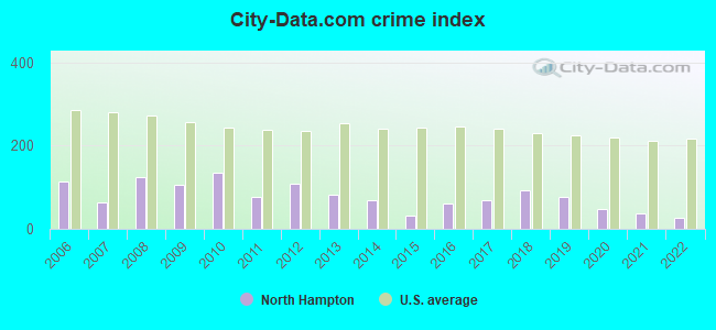
Type |
2009 |
2010 |
2011 |
2012 |
2013 |
2014 |
2015 |
2016 |
2017 |
2018 |
2019 |
2020 |
2021 |
2022 |
|---|---|---|---|---|---|---|---|---|---|---|---|---|---|---|
| Murders (per 100,000) | 0 (0.0) | 0 (0.0) | 0 (0.0) | 0 (0.0) | 0 (0.0) | 0 (0.0) | 0 (0.0) | 0 (0.0) | 0 (0.0) | 0 (0.0) | 0 (0.0) | 0 (0.0) | 0 (0.0) | 0 (0.0) |
| Rapes (per 100,000) | 0 (0.0) | 2 (46.5) | 0 (0.0) | 1 (23.1) | 1 (22.9) | 0 (0.0) | 0 (0.0) | 1 (22.5) | 1 (22.5) | 2 (44.3) | 2 (44.3) | 0 (0.0) | 0 (0.0) | 0 (0.0) |
| Robberies (per 100,000) | 0 (0.0) | 0 (0.0) | 0 (0.0) | 1 (23.1) | 1 (22.9) | 1 (22.8) | 0 (0.0) | 0 (0.0) | 0 (0.0) | 0 (0.0) | 0 (0.0) | 1 (22.2) | 0 (0.0) | 0 (0.0) |
| Assaults (per 100,000) | 3 (66.1) | 3 (69.8) | 1 (23.2) | 2 (46.3) | 2 (45.9) | 0 (0.0) | 0 (0.0) | 1 (22.5) | 1 (22.5) | 2 (44.3) | 1 (22.2) | 0 (0.0) | 2 (43.8) | 1 (22.0) |
| Burglaries (per 100,000) | 27 (595.2) | 18 (418.5) | 16 (371.5) | 10 (231.3) | 11 (252.4) | 13 (295.9) | 5 (112.6) | 8 (180.4) | 8 (179.9) | 6 (133.0) | 6 (133.0) | 3 (66.5) | 0 (0.0) | 4 (88.0) |
| Thefts (per 100,000) | 53 (1,168) | 57 (1,325) | 40 (928.7) | 63 (1,457) | 29 (665.3) | 42 (955.8) | 25 (563.2) | 25 (563.7) | 33 (742.1) | 38 (842.6) | 26 (576.2) | 33 (731.2) | 28 (613.8) | 17 (374.0) |
| Auto thefts (per 100,000) | 3 (66.1) | 1 (23.3) | 5 (116.1) | 0 (0.0) | 1 (22.9) | 1 (22.8) | 1 (22.5) | 1 (22.5) | 2 (45.0) | 3 (66.5) | 3 (66.5) | 4 (88.6) | 2 (43.8) | 0 (0.0) |
| Arson (per 100,000) | 0 (0.0) | 1 (23.3) | 0 (0.0) | 1 (23.1) | 0 (0.0) | 1 (22.8) | 0 (0.0) | 2 (45.1) | 0 (0.0) | 0 (0.0) | 2 (44.3) | 0 (0.0) | 1 (21.9) | 1 (22.0) |
| City-Data.com crime index | 106.9 | 135.3 | 77.1 | 109.2 | 80.5 | 67.6 | 32.2 | 59.5 | 68.4 | 92.7 | 77.6 | 47.6 | 36.8 | 25.5 |
The City-Data.com crime index weighs serious crimes and violent crimes more heavily. Higher means more crime, U.S. average is 246.1. It adjusts for the number of visitors and daily workers commuting into cities.
Crime rate in North Hampton detailed stats: murders, rapes, robberies, assaults, burglaries, thefts, arson
Full-time law enforcement employees in 2021, including police officers: 13 (12 officers - 10 male; 2 female).
| Officers per 1,000 residents here: | 2.63 |
| New Hampshire average: | 2.14 |
 Recent articles from our blog. Our writers, many of them Ph.D. graduates or candidates, create easy-to-read articles on a wide variety of topics.


 | Hampton Beach is packed on weekends (11 replies) |
| Planning a trip to NH (2 replies) |
| Moving to southeast NH, looking for suggestions (22 replies) |
| First visit to NH (28 replies) |
| Town recommendations for a job in Portsmouth (8 replies) |
| North Hampton vs. Rye (4 replies) |
Latest news from North Hampton, NH collected exclusively by city-data.com from local newspapers, TV, and radio stations
Ancestries: English (24.3%), Irish (23.4%), French (11.9%), German (10.3%), Italian (9.7%), Scottish (6.6%).
Current Local Time: EST time zone
Incorporated in 1742
Elevation: 105 feet
Land area: 13.9 square miles.
Population density: 309 people per square mile (very low).
94 residents are foreign born (1.4% Europe, 0.3% North America, 0.3% Asia).
| This town: | 2.2% |
| New Hampshire: | 4.4% |
| North Hampton town: | 1.7% ($3,257) |
| New Hampshire: | 2.3% ($2,946) |
Nearest city with pop. 50,000+: Haverhill, MA  (18.9 miles , pop. 58,969).
Nearest city with pop. 200,000+: Boston, MA (47.3 miles , pop. 589,141).
Nearest city with pop. 1,000,000+: Bronx, NY (215.0 miles , pop. 1,332,650).
Nearest cities:
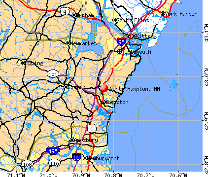
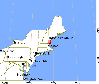
), ), ), )Latitude: 42.98 N, Longitude: 70.83 W
Area code commonly used in this area: 603

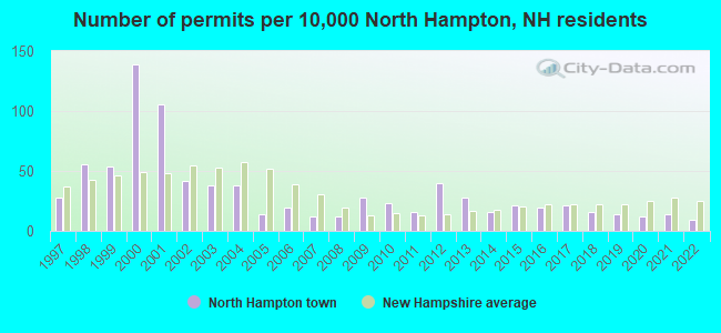
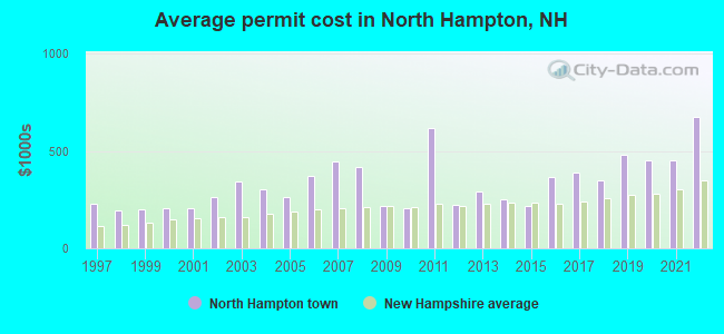
Single-family new house construction building permits:
- 2022: 4 buildings, average cost: $675,500
- 2021: 6 buildings, average cost: $452,100
- 2020: 5 buildings, average cost: $452,100
- 2019: 6 buildings, average cost: $478,300
- 2018: 7 buildings, average cost: $347,100
- 2017: 9 buildings, average cost: $391,000
- 2016: 8 buildings, average cost: $363,600
- 2015: 9 buildings, average cost: $214,900
- 2014: 7 buildings, average cost: $249,100
- 2013: 12 buildings, average cost: $290,100
- 2012: 17 buildings, average cost: $222,300
- 2011: 7 buildings, average cost: $614,600
- 2010: 10 buildings, average cost: $204,400
- 2009: 12 buildings, average cost: $216,800
- 2008: 5 buildings, average cost: $420,400
- 2007: 5 buildings, average cost: $444,800
- 2006: 8 buildings, average cost: $368,800
- 2005: 6 buildings, average cost: $264,200
- 2004: 16 buildings, average cost: $303,200
- 2003: 16 buildings, average cost: $341,900
- 2002: 18 buildings, average cost: $262,000
- 2001: 45 buildings, average cost: $208,000
- 2000: 59 buildings, average cost: $208,000
- 1999: 23 buildings, average cost: $203,000
- 1998: 24 buildings, average cost: $197,000
- 1997: 12 buildings, average cost: $231,300
| Here: | 2.7% |
| New Hampshire: | 2.5% |


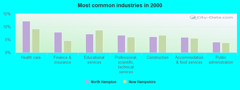
- Health care (12.2%)
- Finance & insurance (7.9%)
- Educational services (7.2%)
- Professional, scientific, technical services (6.7%)
- Construction (6.2%)
- Accommodation & food services (5.9%)
- Public administration (4.1%)
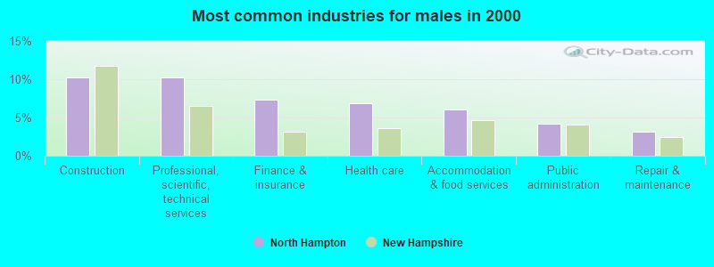
- Construction (10.2%)
- Professional, scientific, technical services (10.2%)
- Finance & insurance (7.4%)
- Health care (6.9%)
- Accommodation & food services (6.0%)
- Public administration (4.2%)
- Repair & maintenance (3.1%)
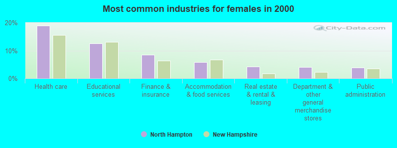
- Health care (19.0%)
- Educational services (12.6%)
- Finance & insurance (8.5%)
- Accommodation & food services (5.8%)
- Real estate & rental & leasing (4.3%)
- Department & other general merchandise stores (4.1%)
- Public administration (4.0%)
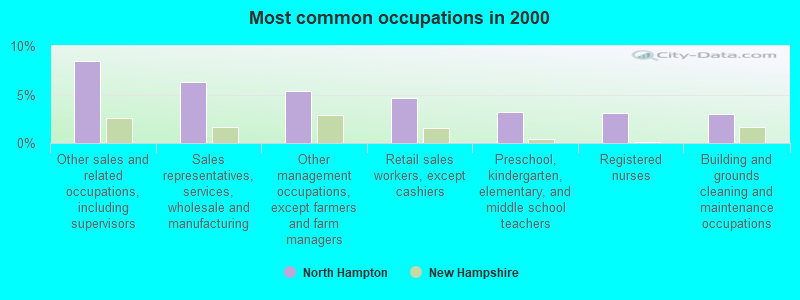
- Other sales and related occupations, including supervisors (8.4%)
- Sales representatives, services, wholesale and manufacturing (6.3%)
- Other management occupations, except farmers and farm managers (5.4%)
- Retail sales workers, except cashiers (4.6%)
- Preschool, kindergarten, elementary, and middle school teachers (3.1%)
- Registered nurses (3.1%)
- Building and grounds cleaning and maintenance occupations (3.0%)
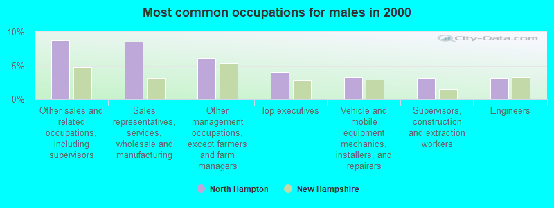
- Other sales and related occupations, including supervisors (8.8%)
- Sales representatives, services, wholesale and manufacturing (8.5%)
- Other management occupations, except farmers and farm managers (6.1%)
- Top executives (4.0%)
- Vehicle and mobile equipment mechanics, installers, and repairers (3.3%)
- Supervisors, construction and extraction workers (3.1%)
- Engineers (3.1%)
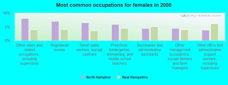
- Other sales and related occupations, including supervisors (8.0%)
- Registered nurses (7.0%)
- Retail sales workers, except cashiers (6.5%)
- Preschool, kindergarten, elementary, and middle school teachers (5.8%)
- Secretaries and administrative assistants (4.5%)
- Other management occupations, except farmers and farm managers (4.5%)
- Other office and administrative support workers, including supervisors (3.9%)
Average climate in North Hampton, New Hampshire
Based on data reported by over 4,000 weather stations


(lower is better)
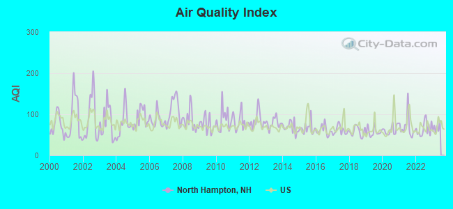
Air Quality Index (AQI) level in 2022 was 64.4. This is about average.
| City: | 64.4 |
| U.S.: | 72.6 |
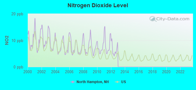
Nitrogen Dioxide (NO2) [ppb] level in 2012 was 6.65. This is worse than average. Closest monitor was 6.9 miles away from the city center.
| City: | 6.65 |
| U.S.: | 5.11 |
Sulfur Dioxide (SO2) [ppb] level in 2022 was 1.48. This is about average. Closest monitor was 6.9 miles away from the city center.
| City: | 1.48 |
| U.S.: | 1.51 |
Ozone [ppb] level in 2022 was 29.6. This is about average. Closest monitor was 4.6 miles away from the city center.
| City: | 29.6 |
| U.S.: | 33.3 |
Particulate Matter (PM10) [µg/m3] level in 2022 was 14.4. This is better than average. Closest monitor was 7.8 miles away from the city center.
| City: | 14.4 |
| U.S.: | 19.2 |
Particulate Matter (PM2.5) [µg/m3] level in 2022 was 6.48. This is better than average. Closest monitor was 7.8 miles away from the city center.
| City: | 6.48 |
| U.S.: | 8.11 |
Tornado activity:
North Hampton-area historical tornado activity is near New Hampshire state average. It is 55% smaller than the overall U.S. average.
On 6/9/1953, a category F3 (max. wind speeds 158-206 mph) tornado 7.1 miles away from the North Hampton town center injured 5 people and caused between $5000 and $50,000 in damages.
On 9/29/1974, a category F3 tornado 31.0 miles away from the town center injured one person and caused between $50,000 and $500,000 in damages.
Earthquake activity:
North Hampton-area historical earthquake activity is significantly above New Hampshire state average. It is 73% smaller than the overall U.S. average.On 10/16/2012 at 23:12:25, a magnitude 4.7 (4.7 ML, Depth: 10.0 mi, Class: Light, Intensity: IV - V) earthquake occurred 43.7 miles away from North Hampton center
On 4/20/2002 at 10:50:47, a magnitude 5.3 (5.3 ML, Depth: 3.0 mi, Class: Moderate, Intensity: VI - VII) earthquake occurred 178.3 miles away from North Hampton center
On 1/19/1982 at 00:14:42, a magnitude 4.7 (4.5 MB, 4.7 MD, 4.5 LG) earthquake occurred 53.0 miles away from the city center
On 10/7/1983 at 10:18:46, a magnitude 5.3 (5.1 MB, 5.3 LG, 5.1 ML) earthquake occurred 188.7 miles away from North Hampton center
On 4/20/2002 at 10:50:47, a magnitude 5.2 (5.2 MB, 4.2 MS, 5.2 MW, 5.0 MW) earthquake occurred 178.1 miles away from North Hampton center
On 8/22/1992 at 12:20:32, a magnitude 4.8 (4.8 MB, 3.8 MS, 4.7 LG, Depth: 6.2 mi) earthquake occurred 269.1 miles away from the city center
Magnitude types: regional Lg-wave magnitude (LG), body-wave magnitude (MB), duration magnitude (MD), local magnitude (ML), surface-wave magnitude (MS), moment magnitude (MW)
Natural disasters:
The number of natural disasters in Rockingham County (26) is a lot greater than the US average (15).Major Disasters (Presidential) Declared: 17
Emergencies Declared: 9
Causes of natural disasters: Storms: 12, Floods: 9, Winter Storms: 5, Hurricanes: 4, Snowstorms: 4, Snows: 2, Winds: 2, Blizzard: 1, Snowfall: 1, Tornado: 1 (Note: some incidents may be assigned to more than one category).
Hospitals and medical centers near North Hampton:
- OCEANSIDE SKILLED NURSING AND REHABILITATION (Nursing Home, about 3 miles away; HAMPTON, NH)
- WEBSTER AT RYE (Nursing Home, about 4 miles away; RYE, NH)
- EXETER ON HAMPTON CARE AND REHABILITATION CENTER (Nursing Home, about 4 miles away; EXETER, NH)
- SEACOAST HOSPICE (Hospital, about 5 miles away; EXETER, NH)
- FMC DIALYSIS SERVICES OF EXETER (Dialysis Facility, about 5 miles away; EXETER, NH)
- EXETER HOSPITAL INC Acute Care Hospitals (about 6 miles away; EXETER, NH)
- EXETER HEALTHCARE (Nursing Home, about 6 miles away; EXETER, NH)
Operable nuclear power plant near North Hampton:
- 7 miles: Seabrook in Seabrook, NH.
Colleges/universities with over 2000 students nearest to North Hampton:
- University of New Hampshire-Main Campus (about 13 miles; Durham, NH; Full-time enrollment: 15,243)
- Northern Essex Community College (about 17 miles; Haverhill, MA; FT enrollment: 4,737)
- Merrimack College (about 27 miles; North Andover, MA; FT enrollment: 2,734)
- North Shore Community College (about 28 miles; Danvers, MA; FT enrollment: 5,195)
- Endicott College (about 30 miles; Beverly, MA; FT enrollment: 4,064)
- Southern New Hampshire University (about 32 miles; Manchester, NH; FT enrollment: 16,552)
- Mount Washington College (about 33 miles; Manchester, NH; FT enrollment: 2,187)
Public elementary/middle school in North Hampton:
- NORTH HAMPTON SCHOOL (Students: 469, Location: 201 ATLANTIC AVE., Grades: PK-8)
Points of interest:
Notable locations in North Hampton: Sagamore Golf Course (A), Sagamore-Hampton Ski Touring Center (B), Hampton Waterworks (C), North Hampton Public Library (D), North Hampton Town Hall (E), North Hampton Fire And Rescue (F). Display/hide their locations on the map
Shopping Center: North Hampton Factory Outlet Shopping Center (1). Display/hide its location on the map
Churches in North Hampton include: United Church of Christ (A), Little River Church (B). Display/hide their locations on the map
Cemetery: Center Cemetery (1). Display/hide its location on the map
Lakes, reservoirs, and swamps: Knowles Pond (A), Philbrick Pond (B), Mill Pond (C), Line Swamp (D), Little River Swamp (E), Black Rock Creek (F). Display/hide their locations on the map
Streams, rivers, and creeks: Oliver Brook (A), North Brook (B), Little River (C), Garland Brook (D), Cornelius Brook (E), Chapel Brook (F), Barton Brook (G). Display/hide their locations on the map
Parks in North Hampton include: Fuller Gardens (1), North Hampton State Park (2). Display/hide their locations on the map
Beach: North Hampton Beach (A). Display/hide its location on the map
Hotel: Pine Haven Motel (183 Lafayette Road) (1). Display/hide its approximate location on the map
Birthplace of: Henry Dearborn - (1751-1829), Congressman, Secretary of War, Todd Checovich - College basketball player (Colgate Red Raiders).
Drinking water stations with addresses in North Hampton and their reported violations in the past:
SAGAMORE/HAMPTON GOLF CLUB (Population served: 150, Groundwater):Past health violations:
- MCL, Monthly (TCR) - Between JUL-2009 and SEP-2009, Contaminant: Coliform. Follow-up actions: St Violation/Reminder Notice (AUG-20-2009), St Public Notif requested (AUG-20-2009), St Public Notif received (AUG-26-2009), St Compliance achieved (AUG-27-2010)
| This town: | 2.4 people |
| New Hampshire: | 2.5 people |
| This town: | 72.5% |
| Whole state: | 66.3% |
| This town: | 5.8% |
| Whole state: | 8.3% |
Likely homosexual households (counted as self-reported same-sex unmarried-partner households)
- Lesbian couples: 0.3% of all households
- Gay men: 0.4% of all households
| This town: | 3.3% |
| Whole state: | 6.5% |
| This town: | 1.6% |
| Whole state: | 2.8% |
Banks with branches in North Hampton (2011 data):
- RBS Citizens, National Association: North Hampton Branch at 65 Lafayette Road, branch established on 1982/09/26. Info updated 2007/09/19: Bank assets: $106,940.6 mil, Deposits: $75,690.2 mil, headquarters in Providence, RI, positive income, 1135 total offices, Holding Company: Uk Financial Investments Limited
- TD Bank, National Association: North Hampton Branch at 46 Lafayette Rd, branch established on 1981/02/02. Info updated 2010/10/04: Bank assets: $188,912.6 mil, Deposits: $153,149.8 mil, headquarters in Wilmington, DE, positive income, 1314 total offices, Holding Company: Toronto-Dominion Bank, The
- Optima Bank & Trust Company: North Hampton Branch at 26 Lafayette Road, branch established on 2009/11/02. Info updated 2012/01/25: Bank assets: $193.5 mil, Deposits: $171.7 mil, headquarters in Portsmouth, NH, positive income, Commercial Lending Specialization, 3 total offices
For population 15 years and over in North Hampton:
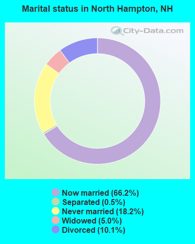
- Never married: 18.2%
- Now married: 66.2%
- Separated: 0.5%
- Widowed: 5.0%
- Divorced: 10.1%
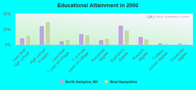
For population 25 years and over in North Hampton:
- High school or higher: 90.9%
- Bachelor's degree or higher: 40.3%
- Graduate or professional degree: 14.9%
- Unemployed: 2.1%
- Mean travel time to work (commute): 25.1 minutes
| Here: | 12.4 |
| New Hampshire average: | 10.9 |


Graphs represent county-level data. Detailed 2008 Election Results
Religion statistics for North Hampton, NH (based on Rockingham County data)


| Religion | Adherents | Congregations |
|---|---|---|
| Catholic | 84,697 | 24 |
| Mainline Protestant | 19,072 | 78 |
| Evangelical Protestant | 7,456 | 61 |
| Other | 3,490 | 20 |
| Orthodox | 200 | 1 |
| None | 180,308 | - |
Food Environment Statistics:
| This county: | 1.59 / 10,000 pop. |
| State: | 2.14 / 10,000 pop. |
| This county: | 0.17 / 10,000 pop. |
| State: | 0.15 / 10,000 pop. |
| Here: | 1.86 / 10,000 pop. |
| State: | 1.78 / 10,000 pop. |
| Rockingham County: | 3.31 / 10,000 pop. |
| State: | 4.02 / 10,000 pop. |
| Here: | 9.56 / 10,000 pop. |
| State: | 9.70 / 10,000 pop. |
| This county: | 7.6% |
| State: | 7.6% |
| Rockingham County: | 23.3% |
| State: | 24.4% |
| Rockingham County: | 16.8% |
| New Hampshire: | 15.9% |
7.69% of this county's 2021 resident taxpayers lived in other counties in 2020 ($114,534 average adjusted gross income)
| Here: | 7.69% |
| New Hampshire average: | 7.66% |
0.01% of residents moved from foreign countries ($203 average AGI)
Rockingham County: 0.01% New Hampshire average: 0.01%
Top counties from which taxpayers relocated into this county between 2020 and 2021:
| from Essex County, MA | |
| from Hillsborough County, NH | |
| from Middlesex County, MA |
6.82% of this county's 2020 resident taxpayers moved to other counties in 2021 ($88,778 average adjusted gross income)
| Here: | 6.82% |
| New Hampshire average: | 6.80% |
0.01% of residents moved to foreign countries ($126 average AGI)
Rockingham County: 0.01% New Hampshire average: 0.01%
Top counties to which taxpayers relocated from this county between 2020 and 2021:
| to Hillsborough County, NH | |
| to Strafford County, NH | |
| to Essex County, MA |
| Businesses in North Hampton, NH | ||||
| Name | Count | Name | Count | |
|---|---|---|---|---|
| Circle K | 1 | Marshalls | 1 | |
| DHL | 1 | MasterBrand Cabinets | 6 | |
| DressBarn | 1 | Maurices | 1 | |
| Dressbarn | 1 | Quiznos | 1 | |
| Dunkin Donuts | 1 | Rite Aid | 1 | |
| Famous Footwear | 1 | Shaw's | 1 | |
| FedEx | 2 | Staples | 1 | |
| Ford | 1 | Subaru | 1 | |
| GNC | 1 | Subway | 1 | |
| GameStop | 1 | U-Haul | 1 | |
| Hyundai | 1 | UPS | 3 | |
Strongest AM radio stations in North Hampton:
- WGIP (1540 AM; 5 kW; EXETER, NH; Owner: CAPSTAR TX LIMITED PARTNERSHIP)
- WRKO (680 AM; 50 kW; BOSTON, MA; Owner: ENTERCOM BOSTON LICENSE, LLC)
- WGIN (930 AM; 10 kW; ROCHESTER, NH; Owner: CAPSTAR TX LIMITED PARTNERSHIP)
- WBZ (1030 AM; 50 kW; BOSTON, MA; Owner: INFINITY BROADCASTING OPERATIONS, INC.)
- WEEI (850 AM; 50 kW; BOSTON, MA; Owner: ENTERCOM BOSTON LICENSE, LLC)
- WTSN (1270 AM; 5 kW; DOVER, NH; Owner: GARRISON CITY BROADCASTING, INC.)
- WMYF (1380 AM; 1 kW; PORTSMOUTH, NH; Owner: CAPSTAR TX LIMITED PARTNERSHIP)
- WWZN (1510 AM; 50 kW; BOSTON, MA; Owner: ROSE CITY RADIO CORPORATION)
- WKOX (1200 AM; 50 kW; FRAMINGHAM, MA; Owner: CAPSTAR TX LIMITED PARTNERSHIP)
- WDER (1320 AM; 10 kW; DERRY, NH; Owner: BLOUNT COMMUNICATIONS, INC. OF NH)
- WBIX (1060 AM; 40 kW; NATICK, MA; Owner: LANGER BROADCASTING CORPORATION)
- WCRN (830 AM; 50 kW; WORCESTER, MA; Owner: CARTER BROADCASTING CORPORATION)
- WRCA (1330 AM; 25 kW; WALTHAM, MA; Owner: WRCA LICENSE, LLC)
Strongest FM radio stations in North Hampton:
- WERZ (107.1 FM; EXETER, NH; Owner: CAPSTAR TX LIMITED PARTNERSHIP)
- WHEB (100.3 FM; PORTSMOUTH, NH; Owner: CAPSTAR TX LIMITED PARTNERSHIP)
- WSAK (102.1 FM; HAMPTON, NH; Owner: CITADEL BROADCASTING COMPANY)
- WNEF (91.7 FM; NEWBURYPORT, MA; Owner: UNIVERSITY OF MASSACHUSETTS)
- WUBB (95.3 FM; YORK CENTER, ME; Owner: CAPSTAR TX LIMITED PARTNERSHIP)
- WXRV (92.5 FM; HAVERHILL, MA; Owner: BEANPOT BROADCASTING CORP.)
- WSHK (105.3 FM; KITTERY, ME; Owner: CITADEL BROADCASTING COMPANY)
- WOKQ (97.5 FM; DOVER, NH; Owner: CITADEL BROADCASTING COMPANY)
- WSCY (106.9 FM; MOULTONBOROUGH, NH; Owner: NORTHEAST COMMUNICATIONS CORPORATION)
- WGIR-FM (101.1 FM; MANCHESTER, NH; Owner: CAPSTAR TX LIMITED PARTNERSHIP)
- WUNH (91.3 FM; DURHAM, NH; Owner: UNIVERSITY OF NEW HAMPSHIRE)
- WMEA (90.1 FM; PORTLAND, ME; Owner: MAINE PUBLIC BROADCASTING CORPORATION)
- WQLL (96.5 FM; BEDFORD, NH; Owner: SAGA COMMUNICATIONS OF NEW ENGLAND, LLC)
- WXKS-FM (107.9 FM; MEDFORD, MA; Owner: AMFM RADIO LICENSES, L.L.C.)
- WLMW (90.7 FM; MANCHESTER, NH; Owner: KNOWLEDGE FOR LIFE)
- WKLB-FM (99.5 FM; LOWELL, MA; Owner: GREATER BOSTON RADIO, INC.)
- WZID (95.7 FM; MANCHESTER, NH; Owner: SAGA COMMUNICATIONS OF NEW ENGLAND, LLC)
- WMJX (106.7 FM; BOSTON, MA; Owner: GREATER BOSTON RADIO, INC.)
- WMEX (106.5 FM; FARMINGTON, NH; Owner: WIMMEX, LLC)
- WBYY (98.7 FM; SOMERSWORTH, NH; Owner: GARRISON CITY BROADCASTING, INC.)
TV broadcast stations around North Hampton:
- WHDN-LP (Channel 26; BOSTON, MA; Owner: GUENTER MARKSTEINER)
- WMEA-TV (Channel 26; BIDDEFORD, ME; Owner: MAINE PUBLIC BROADCASTING CORP.)
- WFXZ-CA (Channel 24; BOSTON, MA; Owner: BOSTON BROADCASTING CORP.)
- WENH-TV (Channel 11; DURHAM, NH; Owner: UNIVERSITY OF NEW HAMPSHIRE)
- WMFP (Channel 62; LAWRENCE, MA; Owner: WSAH LICENSE, INC.)
- WSBK-TV (Channel 38; BOSTON, MA; Owner: VIACOM INC.)
- National Bridge Inventory (NBI) Statistics
- 14Number of bridges
- 161ft / 49.2mTotal length
- $28,278,000Total costs
- 379,066Total average daily traffic
- 33,667Total average daily truck traffic
- New bridges - historical statistics
- 21920-1929
- 11930-1939
- 101970-1979
- 12000-2009
FCC Registered Antenna Towers:
14 (See the full list of FCC Registered Antenna Towers in North Hampton)FCC Registered Broadcast Land Mobile Towers:
3- South Rd (Lat: 42.978139 Lon: -70.860889), Call Sign: KUI648, Licensee ID: L00307774,
Assigned Frequencies: 37.9400 MHz, Grant Date: 03/27/2002, Expiration Date: 05/14/2012, Cancellation Date: 07/14/2012, Registrant: State Of New Hampshire, John O Morton Bldg, Concord, NH 03301, Phone: (603) 271-2693
- Fire Station Atlantic Ave (Lat: 42.973417 Lon: -70.829222), Type: Tower, Structure height: 8 m, Overall height: 15 m, Call Sign: WRX797,
Assigned Frequencies: 156.225 MHz, Grant Date: 01/16/2015, Expiration Date: 04/06/2025, Registrant: 2-Way Communications Service, Inc., 23 River Road, Newington, NH 03801-2832, Phone: (603) 431-6288, Fax: (603) 431-4832, Email:
- 101 North Rd (Lat: 42.992778 Lon: -70.845278), Call Sign: WPUX655,
Assigned Frequencies: 461.512 MHz, 466.512 MHz, Grant Date: 03/31/2012, Expiration Date: 05/22/2022, Cancellation Date: 07/23/2022, Certifier: David W Bergquist, Registrant: National License Corporation, 9050 Briarclift Rd, Indianapolis, IN 46256, Phone: (317) 849-5866, Email:
FCC Registered Microwave Towers:
1- N HAMPTON, South Rd & I95 (Lat: 42.968389 Lon: -70.856333), Overall height: 60 m, Call Sign: WPNI468,
Assigned Frequencies: 17725.0 MHz, Grant Date: 09/19/1997, Expiration Date: 02/01/2001, Cancellation Date: 05/06/2001, Registrant: Sprint Spectrum L.P., 11880 College Blvd, Overland Park, KS 66210, Phone: (913) 315-2153, Fax: (913) 315-2021, Email:
FCC Registered Amateur Radio Licenses:
40 (See the full list of FCC Registered Amateur Radio Licenses in North Hampton)FAA Registered Aircraft:
22 (See the full list of FAA Registered Aircraft in North Hampton)2002 - 2018 National Fire Incident Reporting System (NFIRS) incidents
- Fire incident types reported to NFIRS in North Hampton, NH
- 16240.4%Outside Fires
- 13633.9%Structure Fires
- 7117.7%Mobile Property/Vehicle Fires
- 328.0%Other
 According to the data from the years 2002 - 2018 the average number of fire incidents per year is 24. The highest number of reported fires - 35 took place in 2016, and the least - 3 in 2004. The data has a rising trend.
 When looking into fire subcategories, the most reports belonged to: Outside Fires (40.4%), and Structure Fires (33.9%).
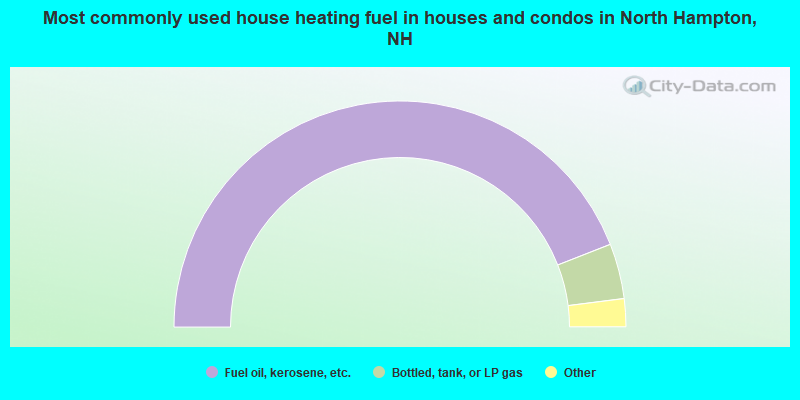
- 88.0%Fuel oil, kerosene, etc.
- 7.9%Bottled, tank, or LP gas
- 2.5%Electricity
- 1.5%Wood
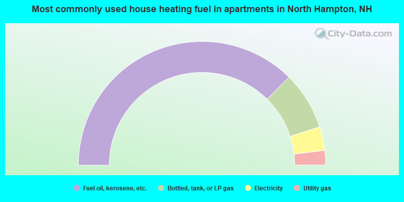
- 74.9%Fuel oil, kerosene, etc.
- 15.2%Bottled, tank, or LP gas
- 6.2%Electricity
- 3.8%Utility gas
North Hampton compared to New Hampshire state average:
- Median house value above state average.
- Unemployed percentage significantly below state average.
- Black race population percentage below state average.
- Hispanic race population percentage significantly below state average.
- Foreign-born population percentage significantly below state average.
- Renting percentage significantly below state average.
- Length of stay since moving in significantly above state average.
- Number of rooms per house significantly below state average.
- House age significantly below state average.

|
|
Total of 143 patent applications in 2008-2024.