Please register to participate in our discussions with 2 million other members - it's free and quick! Some forums can only be seen by registered members. After you create your account, you'll be able to customize options and access all our 15,000 new posts/day with fewer ads.
You were right about arbitrary you went all NY Metro on the Houston area. You shopped off some of its MSA and some of its CSA. Midland and Odessa are separated.
It is also very lopsided.
The biggest area has over 14M people, the smallest has 1M.
Serious question, is there any reason for joining Austin with DFW in the same state while separating it from Frederickburg and the rest of the Hill Country Lubbock, midland and Odessa?
I know you said you drew it arbitrarily but was wondering if their is a reason for that one in particular?
I've always liked the idea of multi-state metro areas, so I had the opportumity to do it here, several times.
The Colorado River starts as the border between Central and Southwestern Texas, but the Mexican influence in San Antonio and the lower Hill Country is arguably more pronounced than in the Austin area, so I kept those two seperate. I also wanted Cen Tx to be the "major" state, held down by two major metros. I didn't care to get too far into the dynamics of population figures, though.
They even look like real states. Central Texas resembles Ohio, the Northwestern portion has the whole Western U.S.-block thing, Southwestern looks like a confused Florida, and East Texas has the north-south slab, like the other southern states.
I think my map is sexy.
lol, doesn't look sexy to me.
And I am not talking about the silly little mexican towns near San Antonio. I am talking about the little German towns in the Hill country that up to a decade ago were 90% German. They most certainly have more in common with the Hill country than San Antonio. Fredricksburg, Luckenbach, even Gruene are more historically German than Mexican.
slicing and dicing metros was one thing, but slicing up the Hill country was just flat out craziness. I hereby revoke your cartography permit.
and fyi My original state maps are sexier.
Your Oklahoma, Arkansas, and Louisiana look like three turds. They have no recognizable shape, so no, I think not.
Your map is too practical. I just had fun with mine.
...but we can take this to the Texas forum and see whose map gets the most votes. You game?
Your Oklahoma, Arkansas, and Louisiana look like three turds. They have no recognizable shape, so no, I think not. :P
Your map is too practical. I just had fun with mine.
...but we can take this to the Texas forum and see whose map gets the most votes. You game?
states are not supposed to have recognizable shapes. and turds are shapes too.
besides, you missed the point of the exercise. The point was to have more uniformity of representation, not to have Ohio shaped states. You might as well leave the states how they are then.
Mine has almost all of states having a population of 4-12 million people, with most having somewhere in the middle.
anyway, I am game for moving it to the Texas forum.
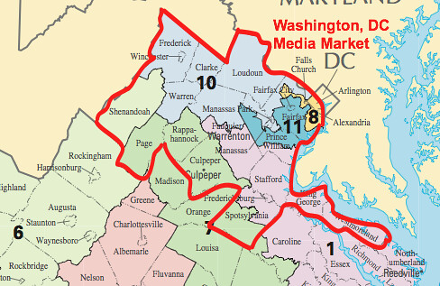
I hope that DC can be it own state and take the Maryland and Virginia suburbs with it. That will turn both VA and MD into permanent Republican states and rid the rest of Maryland from the political stranglehold tthe DC area holds on the state, the way southern Illinois and upstate New York are voiceless against the liberal taxes and nanny state laws and economically destructive environmental and union laws.
Short of that, I hope the Eastern Shores of Maryland and Virginia can be combined with Delaware to form Delmarva. It would also be better if Western Maryland could become merged with West Virginia, then they will not have to deal with the high state taxes from Annapolis, and will be able to develop their natural gas industry and coal mining without the liberal environmental restrictions.
Most people in Virginia wish that Northern Virginia wasn't part of the state. Though its not as bad as the DC suburbs of Maryland since at least southern Virginia is not expected to subsidize NOVA to the extent that rural Maryland subsidizies Montgomery and PG Counties especially transportation and mass transit. The Eastern Shore is self sufficient and suffers high taxes just to support the DC suburbs and Baltimore City. Wihile liberal laws made in the Western Shore hinder economic development and agriculture on the Eastern Shore such as all the laws against septic tank development, all the one size fits all "smart growth" restrictions that make absolutely no sense in small towns, and all the environmental regulations placed on fishing and farming especially.
Pittsburgh, and Western PA should merge with West Virginia and Pittsburgh should become its new capitol. Southwest Ohio should merge with Kentucky. Northeast Ohio should merge with Western NY and the little slice of PA along lake Erie.
Please register to post and access all features of our very popular forum. It is free and quick. Over $68,000 in prizes has already been given out to active posters on our forum. Additional giveaways are planned.
Detailed information about all U.S. cities, counties, and zip codes on our site: City-data.com.

 Please register to participate in our discussions with 2 million other members - it's free and quick! Some forums can only be seen by registered members. After you create your account, you'll be able to customize options and access all our 15,000 new posts/day with fewer ads.

 you went all NY Metro on the Houston area. You shopped off some of its MSA and some of its CSA. Midland and Odessa are separated.