Please register to participate in our discussions with 2 million other members - it's free and quick! Some forums can only be seen by registered members. After you create your account, you'll be able to customize options and access all our 15,000 new posts/day with fewer ads.
Location: Big Island of Hawaii & HOT BuOYS Sailing Vessel
5,277 posts, read 2,801,130 times
Reputation: 1932
Advertisements
1. Shower and thunderstorm activity in association with the broad area of low pressure located over the southwestern Caribbean Sea is beginning to show some signs of organization. Environmental conditions are forecast to steadily become more conducive for development, and this system is expected to become a tropical depression within the next few days. The large disturbance should move slowly northwestward to northward across or near the eastern portions of Nicaragua and Honduras, move into the northwestern Caribbean Sea on Thursday or Friday, and emerge over the southern Gulf of Mexico by the weekend. Interests in Nicaragua and Honduras should monitor the progress of this system over the next couple of days. An Air Force Reserve reconnaissance aircraft is scheduled to investigate the disturbance Wednesday afternoon, if necessary. Regardless of development, this system will likely produce heavy rains over portions of Central America during the next few days. * Formation chance through 48 hours...medium...50 percent. * Formation chance through 5 days...high...70 percent.
Note: To moderator, There is like 98% chance it will be called Nate. Please update title removing question mark if eventually named Nate. Or delete name Nate from title if 2% chance this is not named Nate.
Tropical Weather Outlook
NWS National Hurricane Center Miami FL
200 AM EDT Wed Oct 4 2017
1. Showers and thunderstorms associated with the broad area of low pressure located over the southwestern Caribbean Sea continue to show signs of organization. Environmental conditions are forecast to steadily become more conducive for development, and this system is expected to become a tropical depression within the next couple of days. The large disturbance should move slowly northwestward across or near the eastern portions of Nicaragua and Honduras, move into the northwestern Caribbean Sea on Thursday, and emerge over the southern Gulf of Mexico by the weekend. Interests in Nicaragua,Honduras, Belize, and the Yucatan Peninsula should monitor the progress of this system over the next few days. An Air Force Reserve reconnaissance aircraft is scheduled to investigate the disturbance this afternoon, if necessary. Regardless of development, this system will likely produce heavy rains over portions of Central America during the next few days.
* Formation chance through 48 hours...high...70 percent.
* Formation chance through 5 days...high...80 percent.
2. A trough of low pressure located over central Cuba and extending
northward into the Straits of Florida is producing a broad area
of disorganized showers and thunderstorms across the southern
peninsula of Florida, the northwestern Bahamas, and the adjacent
Atlantic waters. Although significant development of this system
is not expected due to strong upper-level winds, brief squalls will
likely produce locally heavy rainfall and strong gusty winds over
portions of the Bahamas and the southern Florida peninsula during
the next couple of days.
* Formation chance through 48 hours...low...10 percent.
* Formation chance through 5 days...low...10 percent.
Location: Big Island of Hawaii & HOT BuOYS Sailing Vessel
5,277 posts, read 2,801,130 times
Reputation: 1932
Tropical Weather Outlook NWS National Hurricane Center Miami FL 800 AM EDT Wed Oct 4 2017
For the North Atlantic...Caribbean Sea and the Gulf of Mexico:
1. Showers and thunderstorms associated with an area of low pressure located over the southwestern Caribbean Sea have become better organized since yesterday. This system is expected to become a tropical depression later today while it moves northwestward toward the coast of Nicaragua. The low should move slowly northwestward across or near the eastern portions of Nicaragua and Honduras on Thursday, move into the northwestern Caribbean Sea by Friday, and emerge over the southern Gulf of Mexico by Saturday. Interests in Nicaragua, Honduras, the Yucatan peninsula and western Cuba should monitor the progress of this system as watches or warnings could be issued later today. An Air Force Reserve reconnaissance aircraft is scheduled to investigate the disturbance this afternoon. Regardless of development, this system will produce heavy rains over portions of Central America during the next few days, likely causing flash floods and mudslides.
* Formation chance through 48 hours...high...90 percent.
* Formation chance through 5 days...high...90 percent.
.....
Comments this is developing far faster than expected and has time to develop big before impacting areas in US.
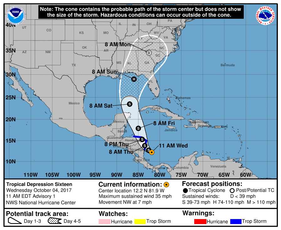
Tropical Depression 16 has formed. Advisories start at 11amEST 4Oct2017.
Heavy scattered rain chances across the SE US due to this system increasing for early next week (subject to change and shifting left/right. 7-day poss totals map shown):
Location: Big Island of Hawaii & HOT BuOYS Sailing Vessel
5,277 posts, read 2,801,130 times
Reputation: 1932
Forecast:
ESTIMATED MINIMUM CENTRAL PRESSURE 1005 MB MAX SUSTAINED WINDS 30 KT WITH GUSTS TO 40 KT. WINDS AND SEAS VARY GREATLY IN EACH QUADRANT. RADII IN NAUTICAL MILES ARE THE LARGEST RADII EXPECTED ANYWHERE IN THAT QUADRANT.
.
REPEAT...CENTER LOCATED NEAR 12.2N 81.9W AT 04/1500Z AT 04/1200Z CENTER WAS LOCATED NEAR 11.9N 81.6W
.
FORECAST VALID 05/0000Z 12.7N 82.6W MAX WIND 35 KT...GUSTS 45 KT. 34 KT... 20NE 0SE 0SW 0NW.
.
FORECAST VALID 05/1200Z 13.8N 83.5W...INLAND MAX WIND 40 KT...GUSTS 50 KT. 34 KT... 30NE 30SE 0SW 0NW.
.
FORECAST VALID 06/0000Z 15.3N 84.1W...INLAND MAX WIND 35 KT...GUSTS 45 KT. 34 KT... 60NE 60SE 0SW 30NW.
.
FORECAST VALID 06/1200Z 17.9N 85.0W MAX WIND 45 KT...GUSTS 55 KT. 34 KT...120NE 70SE 30SW 60NW.
.
FORECAST VALID 07/1200Z 23.5N 87.0W MAX WIND 60 KT...GUSTS 75 KT. 50 KT... 40NE 30SE 0SW 20NW. 34 KT...150NE 90SE 50SW 90NW.
.
EXTENDED OUTLOOK. NOTE...ERRORS FOR TRACK HAVE AVERAGED NEAR 150 NM ON DAY 4 AND 200 NM ON DAY 5...AND FOR INTENSITY NEAR 15 KT EACH DAY.
.
OUTLOOK VALID 08/1200Z 29.0N 86.0W MAX WIND 70 KT...GUSTS 85 KT.
.
OUTLOOK VALID 09/1200Z 34.5N 82.5W...POST-TROP/INLAND MAX WIND 30 KT...GUSTS 40 KT.
.
NEXT ADVISORY AT 04/2100Z
,.........
Notes: Landfall in SE US is predicted to be a Cat 1 and occur around October 8
8pmEST 4-Oct2017: Winds 35mph, moving NW 7mph, pressure 1005mb. Still Tropical Depression 16 but named storm soon likely. Current threat is the HUGE amounts of rain into portions of Central America:
-Nicaragua: 15-20inches, isolated 30inches
-Costa Rica & Panama: 5-10inches, isolated 20inches
-Honduras: 2-5inches, isolated 8inches.
Life threatening flash flooding and mudslides possible.
Appears the other system between FL and Cuba may head up eastern Gulf of Mexico and bring scattered rains and some winds and rougher surf up in advance of this system.
Official 8pmEST NHC cone map (shows ONLY where the center of storm could be in time) (*Note: the GFS model takes the storm into Louisiana, Euro into the Panhandle of FL):
Water temps (in C), storm could be stronger if keeps over the warmer water between Yucatan and Cuba, slightly cooler waters to the West and East of that. Still plenty of warmth to get to a Hurricane, question is how much stronger could it potentially become and that's going to also be determined by how much land interaction and track it takes over the next few days.
Tropical Storm force winds arrival time 5pmEST map (keep in mind the wide spread into the US is also because of storm location uncertainty that far out in time as well):
Location: Big Island of Hawaii & HOT BuOYS Sailing Vessel
5,277 posts, read 2,801,130 times
Reputation: 1932
Forecast 3
TROPICAL DEPRESSION SIXTEEN FORECAST/ADVISORY NUMBER 3 NWS NATIONAL HURRICANE CENTER MIAMI FL AL162017 0300 UTC THU OCT 05 2017
CHANGES IN WATCHES AND WARNINGS WITH THIS ADVISORY...
THE GOVERNMENT OF MEXICO HAS ISSUED A HURRICANE WATCH FROM PUNTA HERRERO TO CABO CATOCHE.
SUMMARY OF WATCHES AND WARNINGS IN EFFECT...
A TROPICAL STORM WARNING IS IN EFFECT FOR... * SANDY BAY SIRPI NICARAGUA TO PUNTA CASTILLA HONDURAS
A HURRICANE WATCH IS IN EFFECT FOR... * PUNTA HERRERO TO CABO CATOCHE MEXICO
A TROPICAL STORM WARNING MEANS THAT TROPICAL STORM CONDITIONS ARE EXPECTED SOMEWHERE WITHIN THE WARNING AREA... IN THIS CASE WITHIN 12-24 HOURS.
A HURRICANE WATCH MEANS THAT HURRICANE CONDITIONS ARE POSSIBLE WITHIN THE WATCH AREA. A WATCH IS TYPICALLY ISSUED 48 HOURS BEFORE THE ANTICIPATED FIRST OCCURRENCE OF TROPICAL-STORM-FORCE WINDS... CONDITIONS THAT MAKE OUTSIDE PREPARATIONS DIFFICULT OR DANGEROUS.
INTERESTS ELSEWHERE IN HONDURAS... THE BAY ISLANDS... WESTERN CUBA AND THE YUCATAN PENINSULA SHOULD MONITOR THE PROGRESS OF THE DEPRESSION.
TROPICAL DEPRESSION CENTER LOCATED NEAR 12.8N 82.7W AT 05/0300Z POSITION ACCURATE WITHIN 20 NM
PRESENT MOVEMENT TOWARD THE NORTHWEST OR 310 DEGREES AT 5 KT
ESTIMATED MINIMUM CENTRAL PRESSURE 1004 MB MAX SUSTAINED WINDS 30 KT WITH GUSTS TO 40 KT. WINDS AND SEAS VARY GREATLY IN EACH QUADRANT. RADII IN NAUTICAL MILES ARE THE LARGEST RADII EXPECTED ANYWHERE IN THAT QUADRANT.
REPEAT...CENTER LOCATED NEAR 12.8N 82.7W AT 05/0300Z AT 05/0000Z CENTER WAS LOCATED NEAR 12.6N 82.6W
FORECAST VALID 05/1200Z 13.5N 83.2W MAX WIND 35 KT...GUSTS 45 KT. 34 KT... 30NE 30SE 0SW 30NW.
FORECAST VALID 06/0000Z 15.1N 83.7W...INLAND MAX WIND 35 KT...GUSTS 45 KT. 34 KT... 30NE 30SE 0SW 30NW.
FORECAST VALID 06/1200Z 17.6N 84.7W MAX WIND 45 KT...GUSTS 55 KT. 34 KT... 70NE 60SE 30SW 50NW.
EXTENDED OUTLOOK. NOTE...ERRORS FOR TRACK HAVE AVERAGED NEAR 150 NM ON DAY 4 AND 200 NM ON DAY 5...AND FOR INTENSITY NEAR 15 KT EACH DAY
OUTLOOK VALID 09/0000Z 30.5N 87.0W...INLAND MAX WIND 65 KT...GUSTS 80 KT.
Please register to post and access all features of our very popular forum. It is free and quick. Over $68,000 in prizes has already been given out to active posters on our forum. Additional giveaways are planned.
Detailed information about all U.S. cities, counties, and zip codes on our site: City-data.com.

 Please register to participate in our discussions with 2 million other members - it's free and quick! Some forums can only be seen by registered members. After you create your account, you'll be able to customize options and access all our 15,000 new posts/day with fewer ads.