Please register to participate in our discussions with 2 million other members - it's free and quick! Some forums can only be seen by registered members. After you create your account, you'll be able to customize options and access all our 15,000 new posts/day with fewer ads.
Quiz.. If 50s and 60s reached as far north as upstate NY, and winds aloft were from the south over entire state of CT, why would northern CT struggle to get out of the 40s??
Maybe you all might find this interesting.. Pop quiz at the bottom.
Quiz.. If 50s and 60s reached as far north as upstate NY, and winds aloft were from the south over entire state of CT, why would northern CT struggle to get out of the 40s??
There is a warm front and the wedge of cold air has yet to retreat from the surface.
This is from our local NWS in their extended forecast discussions. Finally something to watch for and see how this develops as we get closer to the weekend. We're due for a storm of some strength to put down our first heavy base of snow. I'm not as well versed in the climatological terminology as many of you, but I'm sure you will understand the discussion below.
SUNDAY THROUGH TUESDAY (EXTENDED PERIODS)...MEDIUM RANGE MODEL DIFFERENCES REMAIN JUST AS GLARING IN THE DETAILS. ABOUT THE ONLY THING I HAVE SOME CONFIDENCE IN IS SAYING THAT WE TREND COLDER AND MORE UNSETTLED AS TROUGHINESS/COLDER AIR DESCENDS INTO THE CONUS WITH THE ACTIVEBAROCLINIC ZONE/STORM TRACK STRETCHING FROM THE SW STATES UP THROUGH THE GREAT LAKES/OHIO VALLEY INTO NEW ENGLAND. WITH THAT TRACK THE POTENTIAL IS CERTAINLY THERE FOR A DECENT STORM TO DEVELOP AND BRING NRN MICHIGAN A WINTRY STORM.
ECMWF SOLUTION HAD SUCH A STORM IN YESTERDAYS 12Z RUN FOR LATE SUNDAY INTO MONDAY. TODAYS 00Z RUN HAS A WEAKER VERSION BUT THEN DEVELOPS ANOTHER STRONG STORM FOR TUESDAY (A SYSTEM THAT WAS NOT THERE IN THE 12Z RUN). 12Z SOLUTION SUPPRESSES THE STORM TRACK A LITTLE MORE SOUTH AND EAST OF NRN MICHIGAN...INTERESTING.
ON THE FLIP SIDE...GFS WANTS NOTHING TO DO WITH ANY HIGH IMPACT STORMS IMPACTING NRN MICHIGAN THROUGH TUESDAY. INSTEAD...MAINTAINS BROAD HIGH PRESSURE ACROSS THE NRN STATES AND ALSO SUPPRESSES THE STORM TRACK A BIT MORE TO OUR SOUTH AND EAST. WHAT TO DO? AGAIN...GIVEN THE STORM TRACK...POTENTIAL IS CERTAINLY THERE FOR A HIGH IMPACT STORM TO DEVELOP AND TRACK THROUGH THE REGION ANYTIME FROM SATURDAY ONWARD. BUT I JUST DON'T HAVE THE CONFIDENCE YET TO JUMP ON ANY ONE SCENARIO. ONE NOTE HOWEVER...LOW PRESSURE SYSTEMS THAT DEVELOP OVER THE CENTRAL/SOUTHERN PLAINS AREA CLIMATOLOGICAL PREFER A TRACK THROUGH THE GREAT LAKES...NOT THROUGH THE APPALACHIANS AS RECENT GUIDANCE TRENDS SUGGEST.
SO I SUSPECT THAT WE WILL ULTIMATELY HAVE TO DEAL WITH A DECENT STORM BRINGING ACCUMULATING SNOW AND/OR A MIX ACROSS NRN MICHIGAN DURING THE EXTENDED PERIOD. BUT EXACTLY WHEN AND WHETHER OR NOT IT/S HIGH IMPACT IS UP IN THE AIR AT THIS POINT.
Well, quite a few of the ensembles show the AO going to -5, which indicates a truckload of cold coming down to the U.S. Curiously, truckloads of cold haven't been showing up on the models, though a much troughier/stormier pattern is indicated for the central part of the country and New England. The East Coast (ex-New England) and South will be pretty much out of the action, but from what I've seen a pattern change is definitely coming around midmonth. And it doesn't look zonal, either. This is an example from the latest GFS run. It's at the end of the run, but what's shown is rather typical for the upcoming pattern:
Notice how the troughiness is concentrated in the Plains and the Northwest, and to a lesser extent New England. The rest of the country is pretty much out of it. While it isn't a classic meridional pattern, it doesn't look zonal, either. It appears that the cold that is currently concentrated in Western Canada will bleed downward to the PacNW and the Plains, but it seems unable to go all the way down, so to speak.
Since Christmas is 21 days away, it's hard to tell what the pattern will be. It could be that same sort of "meh" pattern that's on the models now, it could be a much colder pattern forced by the AO, or it could be something entirely different (such as a classic cold west/warm east pattern). I myself would lean towards the upcoming pattern persisting but gradually expanding in extent (cold reaching further south and east) for Christmas, but that's just a guess.
Not likely. Once patterns are established they typically last for at least 1-2 weeks, and for what it's worth the long-range models have the mid-month change persisting through at least the 20th. This current warm pattern will probably have lasted about 2 weeks, and some patterns can last for as long as 8 weeks. How long this one will last (1, 2, 4, or 6 weeks) is of course one big question mark.
Keep in mind I'm talking about a pattern - within patterns there are still variations (look through the last 3 winters in your area for good examples). If cold or warmth only lasts for 2 days or so it isn't really a pattern, is it? What I'm looking at is projected to last for at least a week, which would qualify as a pattern change, as opposed to a temporary cold or warm shot, which wouldn't.
I see you're making out like a migratory bird. Good luck.
You still have to watch out for snow. But seriously, although freezes and snow can reach South Florida, you're pretty secure from snow when you get to South Florida; almost all of Florida's snow falls in the north (just as one would expect). South Florida has never recorded snow accumulation, though flurries do occur on very rare occasions.
Yes...I like to think of myself as a migratory bird....I flee when the mean temps fall below 40 F (they do locally in the next week or so). I think I'll be safe from snow in south Florida - there is only one record of snow in Miami in the last 250 years - a trace that lasted for 1 hr and 18 minutes before the sun came up - lol. The normal mid December high is 77 F and the normla low 62 F
As too the pattern coming up in the Canada/USA this December...
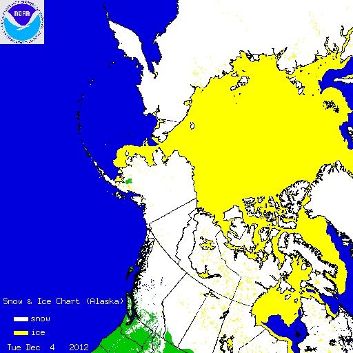
My guess is those east of the Rockies will see little cold/snow as long as the trough stays on the West Coast...which is where it will be without doubt for at least the next 10 days. There IS a alot of cold building in Alaska and NWS Canada...but there is little support for it to come down into the USA. With little or no blocking (NAO netrual or pos) it will be hard to get deep cold and snow down in the northern USA. The southeast ridge is staying put off Florida and shows no signs of retreating closer to West Africa:
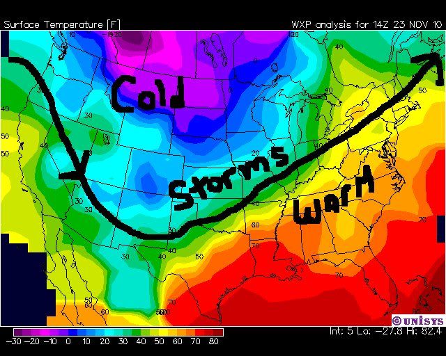
Furthur, as long as the trough stays near/on the West Coast and the southeast subtropical ridge stays off Florida - most of December will feature a warm pattern. When the trough moves east, I think it settles in the north-central Plains in late December. So all areas above the black line will see cooler temps....all areas below the black line stay warm. The storm track will follow the black line from the PNW...to southern plains...to the Great Lakes...to upper New England. So I agree with you there - few storms/snow below Boston on East Coast: The pattern for storms by mid month (I don't see any big storms before that) will look like this:
Otherwise, December will average above normal for about 75% of USA NWS stations is my guess.
This would be a welcome change, but what we really need is snow in the mountains. There are some models that are trying to put some snow in the mountains around the middle of the month and I hope that they are on target for a change. Last year we had snow on the ground in Loveland 29 days in December. There was a bumper crop of snow, but not much very cold air at all. The mountains were starved for snow last year, and another repeat this year will be a disaster.
Hopefully. I assume there's still plenty for skiing? My father is going out there in a couple weeks.
Please register to post and access all features of our very popular forum. It is free and quick. Over $68,000 in prizes has already been given out to active posters on our forum. Additional giveaways are planned.
Detailed information about all U.S. cities, counties, and zip codes on our site: City-data.com.

 Please register to participate in our discussions with 2 million other members - it's free and quick! Some forums can only be seen by registered members. After you create your account, you'll be able to customize options and access all our 15,000 new posts/day with fewer ads.


 . But seriously, although freezes and snow can reach South Florida, you're pretty secure from snow when you get to South Florida; almost all of Florida's snow falls in the north (just as one would expect). South Florida has never recorded snow accumulation, though flurries do occur on very rare occasions.
 I think I'll be safe from snow in south Florida - there is only one record of snow in Miami in the last 250 years - a trace that lasted for 1 hr and 18 minutes before the sun came up