Back to Back Snowstorms East U.S Jan 2015 (live, temps, northern)
Please register to participate in our discussions with 2 million other members - it's free and quick! Some forums can only be seen by registered members. After you create your account, you'll be able to customize options and access all our 15,000 new posts/day with fewer ads.
In case power goes out... just plug in extension cord into this in the car.. and I can have my laptop and a couple lights. I can get internet service on laptop using the cell phone hot spot. Got my wood stove. Got my Gatorade.
Looks like there's still some uncertainty regarding the storm's impact on the western fringes of the area, but it looks like my location is currently forecasted to get at least a foot of snow. NWS is saying 14-24 in the western suburbs. Some maps have shown 6-12 in here.
I work farther south and east. Down there it's expected to be even worse. The 1-3 in expected tomorrow morning might end up preventing me from going to work. If it weren't for that I could probably get at least half a day in tomorrow, but who knows now. Such great timing. 1-3 in isn't much, but it's enough to completely mess up an already hectic morning commute.
Great article from state radio station NJ 101.5:
Quote:
As I mentioned above, literally anywhere from 2 inches to 2 feet of accumulation are possible from this storm. The GFS and Euro forecast models are now on-board with the heavier snowfall, while the NAM lags behind. That’s not really a concern, however, as the NAM usually is the laggard with big storms such as this one.
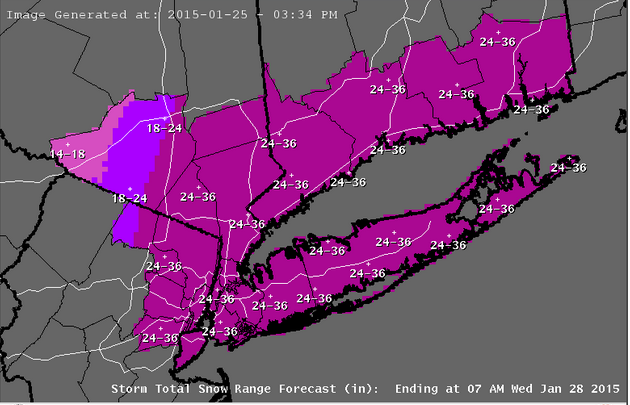
I know you want to see snowfall numbers, but that’s a near-impossible task at the moment, given the huge spread of model output. Obviously, I’m writing this article because this system is forecast to have significant, major winter weather impacts on New Jersey… so we can safely discard the possibility of only a 2-inch storm. The heaviest accumulations will actually be northeast of New Jersey, across Long Island and New England – in fact, a Blizzard Watch is in effect from Hartford, CT up through Boston, MA.
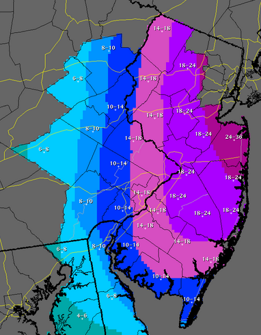
The bottom line is this… a significant, possibly crippling storm is expected Monday night into Tuesday. Confidence is mounting that Northeast New Jersey is expected to receive at least 10 inches of snow, but measurements in “feet” instead of “inches” is a definite possibility. The rest of the state is expected to receive at least 6 inches of snow. I hesitate to even mention the worst-case scenario, but upwards of 2-3 feet of snow accumulation will be possible. That would register as a downright historic storm, especially since meteorologists only gained clarity on the severity of the storm about 48 hours beforehand.
Here is the latest snowfall accumulation forecast from the National Weather Service:
Please register to post and access all features of our very popular forum. It is free and quick. Over $68,000 in prizes has already been given out to active posters on our forum. Additional giveaways are planned.
Detailed information about all U.S. cities, counties, and zip codes on our site: City-data.com.

 Please register to participate in our discussions with 2 million other members - it's free and quick! Some forums can only be seen by registered members. After you create your account, you'll be able to customize options and access all our 15,000 new posts/day with fewer ads.


") 1-3 in isn't much, but it's enough to completely mess up an already hectic morning commute.
1-3 in isn't much, but it's enough to completely mess up an already hectic morning commute.