Please register to participate in our discussions with 2 million other members - it's free and quick! Some forums can only be seen by registered members. After you create your account, you'll be able to customize options and access all our 15,000 new posts/day with fewer ads.
Incredible to see. Peaking before Vermont and New England even has moderate colors. I really wouldn't think the mountains were in NC. Its only 6000 feet. Is Mt Washington even peaking?
I saw where a new daily record low max was set this past Sunday with a high of just 67F, thanks to cloud cover.
It reached 91F today, and the next two days are forecast to exceed 90F. The average high for today's date is 82F.
Yikes! Highest temp forecast in my 10 day is only 83 F. Glad those 90s are over for me. At least your lows are going down into the 50s/low 60s now.
Quote:
Originally Posted by alex985
Remember, the SE was experiencing colder than normal conditions for the first few days of October because of the ample cloud cover.
True. I wonder what the earlier than normal peaks in North Carolina mean for central/south Georgia. Sweetgums, bradford pears, sycamores, and elms here don't peak until Thanksgiving on average. Will it come earlier this year?
The extreme Arctic cold outbreak is continuing here. High's dropped from low 60's to mid 40's in a matter of days, and lows have been well below freezing. 24F here last night. Tomorrow will struggle to get even above 40F. Mid-November weather in other words.
Even more dramatic in Russia. In late September Moscow had almost 80F highs, and tomorrow's forecast has a 36F high.
Your post reminded me to check.. That is awesome. The 850mb freezing line can barely drop south of the Canadian border yet and meanwhile it's dug deeper in Europe to Latitude 44N. -10C line bleeding down to Latitude 50N. Whoever is under those pinks is having some crazy cold right now
I see a lot of cold building in northern Canada/Arctic but I think friggin Nino wont allow it to dig deep into the U.S yet! Too much Pacific flow!
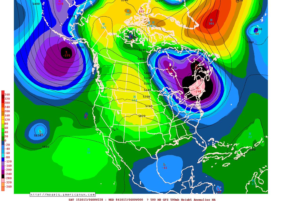
Big difference in the Northeast US for temps on Saturday the 17th! GFS digs the colder trough where the 522DAM line is at the MA/CT border meanwhile Euro Ensembles says the 522 is still way north in Canada. INSANE!!
I mean granted it's still 10 days away but just amazing to see such differences. One is warm, One is Cold.
Lets come back to this post next week!
Just to continue and follow...
GFS continues the notion of an anomalous deep cold trough in the Northeast mid month. Now instead of the 15th has it for the 17th. Euro still not buying.
GFS06z hr234
850mb freezing line down to Virginia. Red line = 925mb freezing line so its below freezing at 2500' north of CT.
I hope that trough pushes down in time for Thanksgiving. A warm dinner with family on a properly cold evening (not the fake 50 F cold) is perfect.
Please register to post and access all features of our very popular forum. It is free and quick. Over $68,000 in prizes has already been given out to active posters on our forum. Additional giveaways are planned.
Detailed information about all U.S. cities, counties, and zip codes on our site: City-data.com.

 Please register to participate in our discussions with 2 million other members - it's free and quick! Some forums can only be seen by registered members. After you create your account, you'll be able to customize options and access all our 15,000 new posts/day with fewer ads.


 That is awesome. The 850mb freezing line can barely drop south of the Canadian border yet and meanwhile it's dug deeper in Europe to Latitude 44N. -10C line bleeding down to Latitude 50N. Whoever is under those pinks is having some crazy cold right now