Please register to participate in our discussions with 2 million other members - it's free and quick! Some forums can only be seen by registered members. After you create your account, you'll be able to customize options and access all our 15,000 new posts/day with fewer ads.
February 2022 Weather Thread (Northern Hemisphere)
February 2022 is definitely a transition month for most of the country where the storms will continue, but typically the bitter cold breaks, spring is around the corner, only 44 days.
North-central VT here...would say we've probably gotten 6-8" overnight with more this morning through early afternoon. Lots of wind blowing as well. Biggest traffic issue here is the line of cars heading to the mountain lol.
Here near Saratoga region in NY we did not get nearly as much as what was reported. Only 5 inches compared to a foot they were saying. That’s because it seemed to stay sleet the whole time even though it was cold at the surface. However, clearly the upper levels were too warm because the winds are coming from the south which brings the warm air up more. So it never switched to snow really and even the radar was wrong as it said snow but was obviously mixed precipitation. Very hard to pinpoint it though exactly that’s why.
North-central VT here...would say we've probably gotten 6-8" overnight with more this morning through early afternoon. Lots of wind blowing as well. Biggest traffic issue here is the line of cars heading to the mountain lol.
You are lucky you aren't dealing with ice or sleet. Post some pics in the Winter Photo thread.
Quote:
Originally Posted by UpstaterNY1
Here near Saratoga region in NY we did not get nearly as much as what was reported. Only 5 inches compared to a foot they were saying. That’s because it seemed to stay sleet the whole time even though it was cold at the surface. However, clearly the upper levels were too warm because the winds are coming from the south which brings the warm air up more. So it never switched to snow really and even the radar was wrong as it said snow but was obviously mixed precipitation. Very hard to pinpoint it though exactly that’s why.
Yeah, impressed how thick the low level cold air is to make it sleet and how the Mid levels aren't cooling down...yet...
Check out Lackawanna, PA. 3/4" ice! Still rain here but surface dropped to 35° now.
The storm has finally passed here in Indianapolis. Kokomo, about 30 minutes north of here, got just over 13 inches of snow. Here in the north suburbs we got between 8 and 9 inches of snow with a glaze of ice under it. Officially at the NWS office, Indianapolis received 7.6 inches of snow from the storm. City streets are beginning to improve a bit but county roads and highways had major drifting overnight and are still a mess, as are the interstates around town. Most things are still closed today but now it's dig out time.
A look at current temps at 5000' and 10,000'. Interesting to see the freezing line aloft that far west while surface temps are crashing or below freezing EAST of it.
Still above freezing "at these levels" east of that line.
THIS IS WHY THERE WILL BE ICE OR SLEET. Precip is falling as rain aloft, and depending how thick the cold air below 4000' is, will determine if its sleet or ice that will be at the surface.
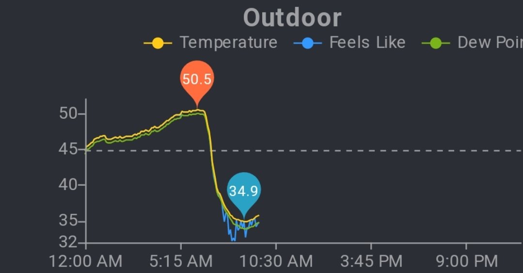
My outdoor temp crashed.. now ticked up past hour..
Please register to post and access all features of our very popular forum. It is free and quick. Over $68,000 in prizes has already been given out to active posters on our forum. Additional giveaways are planned.
Detailed information about all U.S. cities, counties, and zip codes on our site: City-data.com.

 Please register to participate in our discussions with 2 million other members - it's free and quick! Some forums can only be seen by registered members. After you create your account, you'll be able to customize options and access all our 15,000 new posts/day with fewer ads.