Please register to participate in our discussions with 2 million other members - it's free and quick! Some forums can only be seen by registered members. After you create your account, you'll be able to customize options and access all our 15,000 new posts/day with fewer ads.
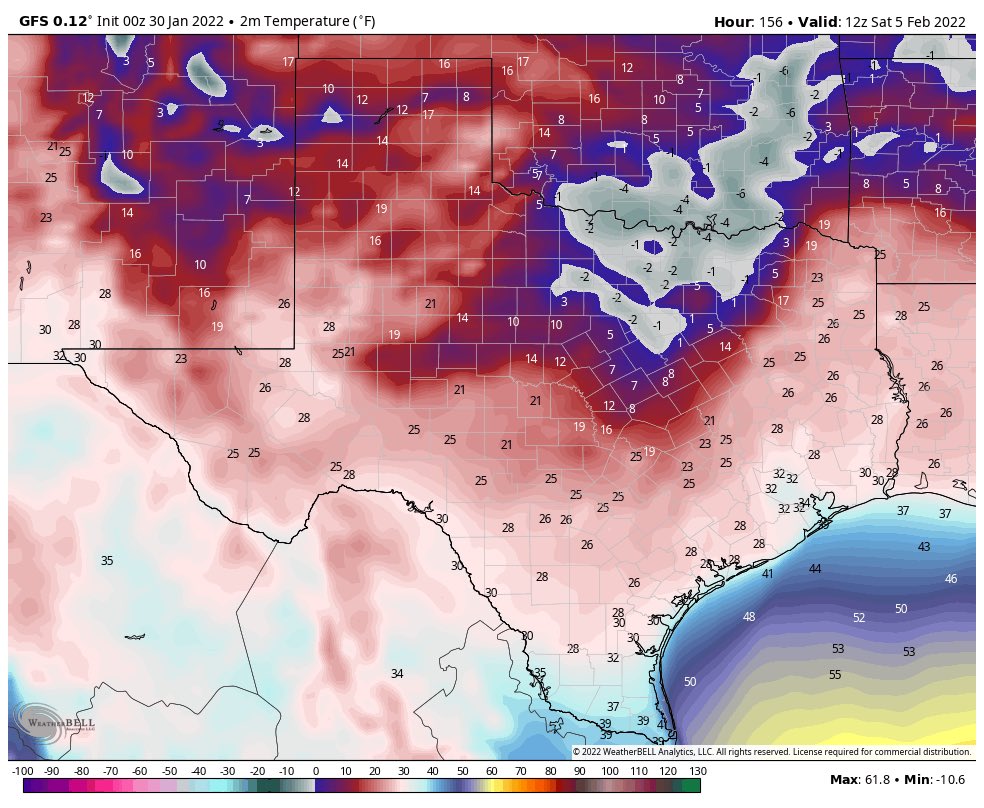
GFS says 21 inches of snow for me 14 inches at Midway 11 inches at ORD. I wish but we all know this is model nonsense for now
I'm hoping the models are overshooting the snow/ice amounts for this upcoming winter storm. Calling for more than I've ever seen for my area of northern Arkansas.
We haven't been above 60F since Jan 19. Warming up today with a forecast high of 68F and warm the next few days before strong cold front arrives Thursday. NWS LCH is mentioning some possibility of seeing wintry precip late this week.
Spoiler
LONG TERM [Wednesday through Sunday]...
By Wednesday, rain chances will be ongoing thanks to a closed upper
level low, however this system will open up and be significantly
weakened. High temperatures that day will reach into the mid 70s
with lows in the mid 40s to 50s. That will be the last of temps like
that for the long term period.
I would say that this strong cold front is coming on the heels of
that, but rain chances do not even leave the area before prefrontal
activity kick in. With showers and isolated thunderstorms ongoing,
the front will push thru on late Wednesday to Thursday. The models
again differ as to the end of precip. The GFS clears this out by
late Thursday, with the Euro following close behind it. However the
Canadian has post frontal activity lingering into late Friday. Opted
to run with the NBM which left 10 to 30 PoPs in for late Thursday,
then decreasing to <15 from there. Depending on how this actually
plays out, the chance of seeing a wintry mix of precip exist. Post
frontal temperatures Thursday into Friday will be cold enough for
wintry precip.
Regardless of wintry precip, it will be quite cold behind the
front. Highs will be in the 40s to 50s. Actual lows will be in the
upper 20s to low 30s with wind chill values in the 20s CWA wide.
Northerly winds behind the front will strengthen, allowing for areas
along the I-10 corridor and south to flirt with possible wind
advisory criteria from Thursday morning into Friday night.. As if
the cold was not enough. Winds will be breezy, but begin to taper
late Friday into Saturday. High pressure will build into the area by
the end of the weekend, leading to more favorable conditions.
I'm hoping the models are overshooting the snow/ice amounts for this upcoming winter storm. Calling for more than I've ever seen for my area of northern Arkansas.
Right now it seems as if the Euro is taking it further south. GEFS and NAM still showing Chicagoland under heavy snow. We'll see where the track goes in the next couple days
What TWC is showing. Btw it annoys me that they are naming these storms.
Eight days in a row here without rain came to an end yesterday--a welcome break given the record-wet autumn followed by the arctic outbreak over the holidays. Front today and tomorrow will bring snow to the mountains which the ski resorts will appreciate.
NWS always communicates forecasts much better than ECCC. Here's the graphic from NWS Seattle for the mountain snow around Seattle. For those not in the know, Victoria is south of the "F" in Friday Harbor.
Currently here, in Downeast, Maine....17F Degrees, Dew Point 4, Winds W8mph, Gusts 17mph, Pressure rising 29.69...
Startlingly, Beautiful, Blue Skies...
Thankful for the prayers of our friends and family. We survived the (approximate),20" of additional snow (premier powder),from yesterday's Blizzard (we already had around six-eight inches with drifts), the electricity did not go out, awoke to our driveway/dooryard being plowed, and heard someone scrambling on our front porch and discovered one of the guys on our volunteer fire department shovelling our pathway (there were drifts all up against our house of up to five feet and he reminded me that I didn't see what he was doing)!
Jon and I were going to have to shovel that pathway...
I guess the saying that kindness is like snow!
It beautifies everything.
35f is all i can muster. No frost. Any amount of wind kills it for me.
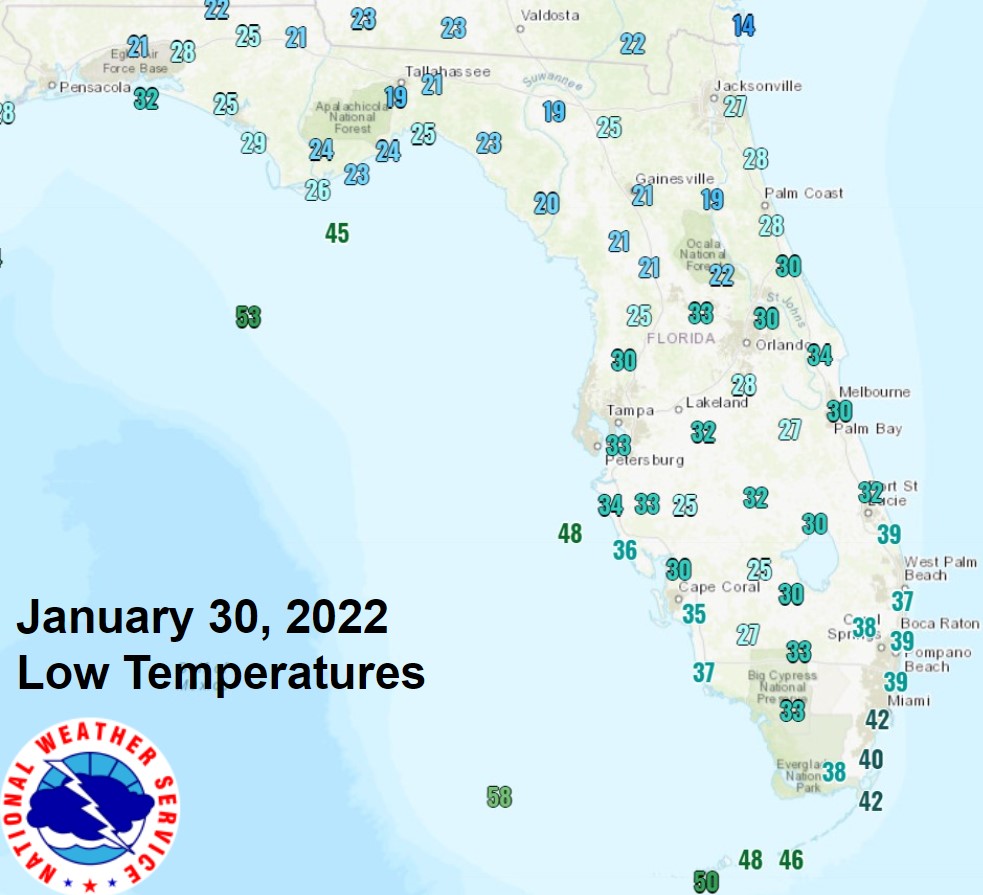
Here are the low temperatures from this morning in Florida. I think the only record low of note is the 46°F in Marathon. Punta Gorda (30°F) and Fort Myers (35°F) each tied records.
Here are the low temperatures from this morning in Florida. I think the only record low of note is the 46°F in Marathon. Punta Gorda (30°F) and Fort Myers (35°F) each tied records.
My seasonal tenants moving in on the 1st for 3 months. Hope the temps climb soon or else my electric bill will be sky high with that pool heater running all day and night
Please register to post and access all features of our very popular forum. It is free and quick. Over $68,000 in prizes has already been given out to active posters on our forum. Additional giveaways are planned.
Detailed information about all U.S. cities, counties, and zip codes on our site: City-data.com.

 Please register to participate in our discussions with 2 million other members - it's free and quick! Some forums can only be seen by registered members. After you create your account, you'll be able to customize options and access all our 15,000 new posts/day with fewer ads.


 14 inches at Midway 11 inches at ORD. I wish but we all know this is model nonsense for now