Pembroke, New York
Submit your own pictures of this town and show them to the world
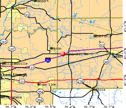
- OSM Map
- General Map
- Google Map
- MSN Map
Population change since 2000: -5.3%
 |
| Males: 2,096 | |
| Females: 2,196 |
| Median resident age: | 43.9 years |
| New York median age: | 40.7 years |
Zip codes: 14036.
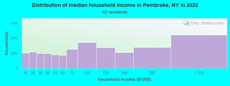
| Pembroke: | $67,836 |
| NY: | $79,557 |
Estimated per capita income in 2022: $32,666 (it was $17,148 in 2000)
Pembroke town income, earnings, and wages data
Estimated median house or condo value in 2022: $173,825 (it was $92,800 in 2000)
| Pembroke: | $173,825 |
| NY: | $400,400 |
Mean prices in 2022: all housing units: $185,048; detached houses: $198,060; townhouses or other attached units: $337,040; in 2-unit structures: $169,572; in 3-to-4-unit structures: $91,733; in 5-or-more-unit structures: $222,028; mobile homes: $56,245; occupied boats, rvs, vans, etc.: $155,195
Detailed information about poverty and poor residents in Pembroke, NY

Compare current foreclosures near Pembroke, NY:
| Photo | Address | Area | Beds / Baths | Price | Details |
|---|---|---|---|---|---|

|
#1
Vernon Ave
Batavia, NY 14020
|
1,470 sq. feet
|
1 baths 3 beds |
$195,000
|
show details |

|
#2
Brewster St
Depew, NY 14043
|
1,056 sq. feet
|
1 baths 3 beds |
$159,000
|
show details |

|
#3
Marengo St
Depew, NY 14043
|
1,632 sq. feet
|
1 baths 4 beds |
show details | |

|
#4
Fisk Rd
Akron, NY 14001
|
1,408 sq. feet
|
1 baths 3 beds |
show details | |

|
#5
Clinton Street Rd
Attica, NY 14011
|
1,782 sq. feet
|
3 baths 3 beds |
show details | |

|
#6
Town Line Rd
Lancaster, NY 14086
|
1,851 sq. feet
|
1 baths 3 beds |
show details | |

|
#7
Roseland Ave
Medina, NY 14103
|
1,572 sq. feet
|
1 baths 3 beds |
show details | |

|
#8
Hemstreet Rd
East Aurora, NY 14052
|
1,468 sq. feet
|
2 baths 4 beds |
show details | |

|
#9
Warren St
Batavia, NY 14020
|
1,280 sq. feet
|
1 baths 4 beds |
show details | |

|
#10
Robertson St
Middleport, NY 14105
|
1,540 sq. feet
|
1 baths 3 beds |
show details |
| Photo | Address | Area | Beds / Baths | Price | Details |
|---|---|---|---|---|---|

|
#11
Washington Ave
Batavia, NY 14020
|
1,926 sq. feet
|
3 baths 4 beds |
show details | |

|
#12
Baby Ln
Medina, NY 14103
|
1,816 sq. feet
|
1 baths 3 beds |
show details | |

|
#13
Exchange St
Attica, NY 14011
|
2,580 sq. feet
|
1 baths 4 beds |
show details | |

|
#14
Thomas Ave
Batavia, NY 14020
|
1,928 sq. feet
|
1 baths 4 beds |
show details | |

|
#15
Harding Rd
Buffalo, NY 14221
|
2,356 sq. feet
|
3 baths 4 beds |
show details | |

|
#16
W Main St
Attica, NY 14011
|
1,130 sq. feet
|
2 baths 3 beds |
show details | |

|
#17
Royalton Center Rd
Gasport, NY 14067
|
1,352 sq. feet
|
2 baths 4 beds |
show details | |

|
#18
Boncliff Dr
Alden, NY 14004
|
1,134 sq. feet
|
1 baths 3 beds |
show details | |

|
#19
Como Park Blvd
Lancaster, NY 14086
|
1,144 sq. feet
|
1 baths 2 beds |
show details | |

|
#20
James St
Batavia, NY 14020
|
1,744 sq. feet
|
2 baths 3 beds |
show details |
| Photo | Address | Area | Beds / Baths | Price | Details |
|---|---|---|---|---|---|

|
#21
Creek Rd
Elma, NY 14059
|
2,310 sq. feet
|
2 baths 4 beds |
show details | |

|
#22
Schultz Rd
Elma, NY 14059
|
1,863 sq. feet
|
3 baths 3 beds |
show details | |

|
#23
Aurora St
Lancaster, NY 14086
|
1,983 sq. feet
|
2 baths 3 beds |
show details | |

|
#24
North Ave
Medina, NY 14103
|
1,546 sq. feet
|
1 baths 4 beds |
show details | |

|
#25
Irwinwood Rd
Lancaster, NY 14086
|
1,470 sq. feet
|
1 baths 3 beds |
show details | |

|
#26
Block Church Rd
Lockport, NY 14094
|
1,260 sq. feet
|
1 baths 2 beds |
show details | |

|
#27
Roberts Grv
Clarence, NY 14031
|
2,666 sq. feet
|
3 baths 4 beds |
show details | |

|
#28
Orient St
Medina, NY 14103
|
1,440 sq. feet
|
2 baths 3 beds |
show details | |

|
#29
Aurora St
Lancaster, NY 14086
|
2,132 sq. feet
|
2 baths 4 beds |
show details | |

|
#30
Sierk Rd
Attica, NY 14011
|
- sq. feet
|
- baths - beds |
$43,900
|
show details |
| Photo | Address | Area | Beds / Baths | Price | Details |
|---|---|---|---|---|---|

|
#31
Caswell Rd
Byron, NY 14422
|
1,008 sq. feet
|
1 baths 3 beds |
show details | |

|
#32
W Oak Orchard St
Medina, NY 14103
|
2,920 sq. feet
|
2 baths 6 beds |
show details | |

|
#33
Shire Dr S
East Amherst, NY 14051
|
2,456 sq. feet
|
3 baths 3 beds |
show details | |

|
#34
Mann Rd
Akron, NY 14001
|
1,260 sq. feet
|
1 baths 3 beds |
show details | |

|
#35
Vine St
Batavia, NY 14020
|
1,416 sq. feet
|
1 baths 3 beds |
show details | |

|
#36
Vine St
Batavia, NY 14020
|
1,858 sq. feet
|
2 baths 4 beds |
show details | |

|
#37
Davis Ave
Batavia, NY 14020
|
1,912 sq. feet
|
3 baths 4 beds |
show details | |

|
#38
Transit Rd
Depew, NY 14043
|
2,304 sq. feet
|
2 baths 4 beds |
show details | |

|
#39
Transit Rd
East Bethany, NY 14054
|
1,243 sq. feet
|
1 baths 3 beds |
show details | |

|
#40
Woodlawn Ave
Lancaster, NY 14086
|
1,154 sq. feet
|
3 baths 3 beds |
show details |
| Photo | Address | Area | Beds / Baths | Price | Details |
|---|---|---|---|---|---|

|
#41
Broadway St
Lancaster, NY 14086
|
1,202 sq. feet
|
2 baths 3 beds |
show details | |

|
#42
W Main St
Lancaster, NY 14086
|
1,842 sq. feet
|
2 baths 3 beds |
show details | |

|
#43
Pin Cherry Ct
East Amherst, NY 14051
|
3,624 sq. feet
|
3 baths 4 beds |
show details | |

|
#44
Bloomingdale Ave
Akron, NY 14001
|
1,518 sq. feet
|
1 baths 4 beds |
show details | |

|
#45
East Ave
Akron, NY 14001
|
1,832 sq. feet
|
2 baths 5 beds |
show details | |

|
#46
W Main Street Rd
Batavia, NY 14020
|
3,216 sq. feet
|
2 baths 4 beds |
show details | |

|
#47
Hartshorn Rd
Corfu, NY 14036
|
1,260 sq. feet
|
1 baths 4 beds |
show details | |

|
#48
Northfield Rd
Clarence Center, NY 14032
|
988 sq. feet
|
1 baths 3 beds |
show details | |

|
#49
Genesee St
Corfu, NY 14036
|
1,458 sq. feet
|
1 baths 3 beds |
show details | |

|
Check over 1 million property listings on Foreclosure.com!
|
browse all offers | |||

- 4,16397.0%White alone
- 411.0%Hispanic
- 370.9%Two or more races
- 250.6%Black alone
- 190.4%American Indian alone
- 60.1%Asian alone
- 10.02%Other race alone
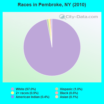
Races in Pembroke detailed stats: ancestries, foreign born residents, place of birth
 Recent articles from our blog. Our writers, many of them Ph.D. graduates or candidates, create easy-to-read articles on a wide variety of topics.

 | Native American culture in NY State (1107 replies) |
| NYS thruway system (342 replies) |
| Veteran friendly....... (490 replies) |
| Relocating for autism services (212 replies) |
| Buffalo and WNY Greatest Ambassador (102 replies) |
| Syracuse Construction Update (4341 replies) |
Latest news from Pembroke, NY collected exclusively by city-data.com from local newspapers, TV, and radio stations
Ancestries: German (42.8%), Polish (19.4%), Irish (18.3%), English (15.9%), Italian (10.0%), Dutch (3.8%).
Current Local Time: EST time zone
Elevation: 845 feet
Land area: 41.7 square miles.
Population density: 103 people per square mile (very low).
66 residents are foreign born
| This town: | 1.5% |
| New York: | 20.4% |
| Pembroke town: | 2.6% ($2,384) |
| New York: | 1.9% ($2,847) |
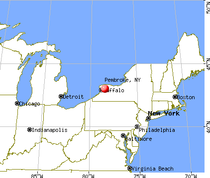
Nearest city with pop. 50,000+: Amherst, NY  (19.0 miles , pop. 116,510).
Nearest city with pop. 200,000+: Buffalo, NY (23.9 miles , pop. 292,648).
Nearest city with pop. 1,000,000+: Philadelphia, PA (266.4 miles , pop. 1,517,550).
Nearest cities:
), ), ), ), ), )Latitude: 42.99 N, Longitude: 78.39 W
Area code commonly used in this area: 585

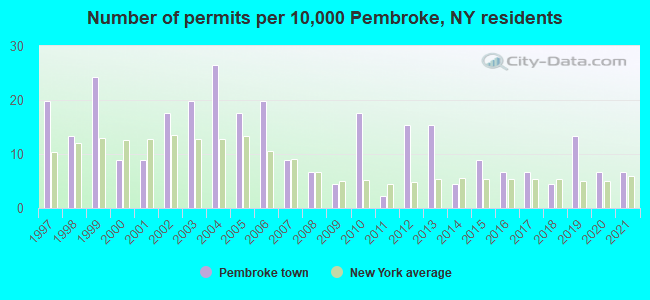
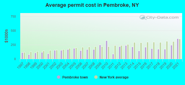
Single-family new house construction building permits:
- 2021: 3 buildings, average cost: $359,400
- 2020: 3 buildings, average cost: $243,300
- 2019: 6 buildings, average cost: $177,400
- 2018: 2 buildings, average cost: $175,000
- 2017: 3 buildings, average cost: $183,300
- 2016: 3 buildings, average cost: $209,400
- 2015: 4 buildings, average cost: $145,000
- 2014: 2 buildings, average cost: $215,000
- 2013: 7 buildings, average cost: $238,000
- 2012: 7 buildings, average cost: $218,300
- 2011: 1 building, cost: $89,000
- 2010: 8 buildings, average cost: $325,900
- 2009: 2 buildings, average cost: $248,800
- 2008: 3 buildings, average cost: $168,800
- 2007: 4 buildings, average cost: $168,800
- 2006: 9 buildings, average cost: $147,800
- 2005: 8 buildings, average cost: $191,100
- 2004: 12 buildings, average cost: $168,400
- 2003: 9 buildings, average cost: $157,200
- 2002: 8 buildings, average cost: $155,900
- 2001: 4 buildings, average cost: $95,000
- 2000: 4 buildings, average cost: $119,900
- 1999: 11 buildings, average cost: $110,700
- 1998: 6 buildings, average cost: $81,800
- 1997: 9 buildings, average cost: $113,600
| Here: | 3.9% |
| New York: | 4.4% |
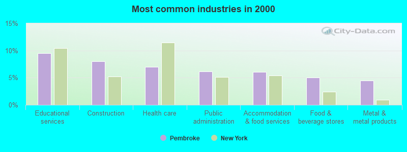
- Educational services (9.5%)
- Construction (8.0%)
- Health care (7.0%)
- Public administration (6.2%)
- Accommodation & food services (6.1%)
- Food & beverage stores (5.0%)
- Metal & metal products (4.4%)
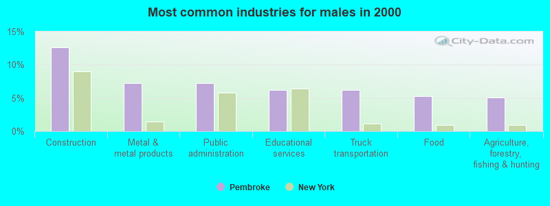
- Construction (12.7%)
- Metal & metal products (7.3%)
- Public administration (7.2%)
- Educational services (6.3%)
- Truck transportation (6.3%)
- Food (5.3%)
- Agriculture, forestry, fishing & hunting (5.1%)
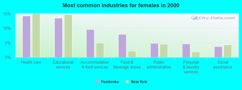
- Health care (14.3%)
- Educational services (13.6%)
- Accommodation & food services (9.7%)
- Food & beverage stores (8.0%)
- Public administration (4.9%)
- Personal & laundry services (4.7%)
- Social assistance (3.7%)
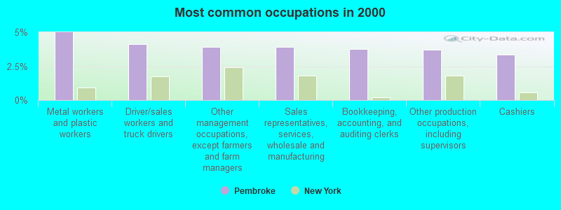
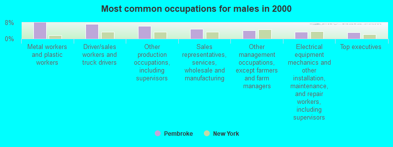
- Metal workers and plastic workers (5.0%)
- Driver/sales workers and truck drivers (4.1%)
- Other management occupations, except farmers and farm managers (3.9%)
- Sales representatives, services, wholesale and manufacturing (3.9%)
- Bookkeeping, accounting, and auditing clerks (3.8%)
- Other production occupations, including supervisors (3.7%)
- Cashiers (3.4%)
- Metal workers and plastic workers (8.0%)
- Driver/sales workers and truck drivers (7.3%)
- Other production occupations, including supervisors (6.3%)
- Sales representatives, services, wholesale and manufacturing (4.8%)
- Other management occupations, except farmers and farm managers (4.2%)
- Electrical equipment mechanics and other installation, maintenance, and repair workers, including supervisors (3.4%)
- Top executives (3.0%)
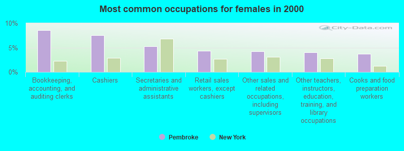
- Bookkeeping, accounting, and auditing clerks (8.6%)
- Cashiers (7.5%)
- Secretaries and administrative assistants (5.3%)
- Retail sales workers, except cashiers (4.3%)
- Other sales and related occupations, including supervisors (4.2%)
- Other teachers, instructors, education, training, and library occupations (4.0%)
- Cooks and food preparation workers (3.7%)
Average climate in Pembroke, New York
Based on data reported by over 4,000 weather stations


(lower is better)
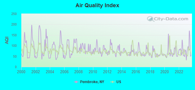
Air Quality Index (AQI) level in 2023 was 86.0. This is about average.
| City: | 86.0 |
| U.S.: | 72.6 |
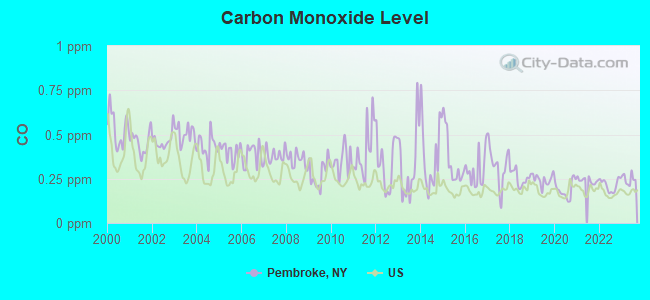
Carbon Monoxide (CO) [ppm] level in 2023 was 0.248. This is about average. Closest monitor was 19.3 miles away from the city center.
| City: | 0.248 |
| U.S.: | 0.251 |
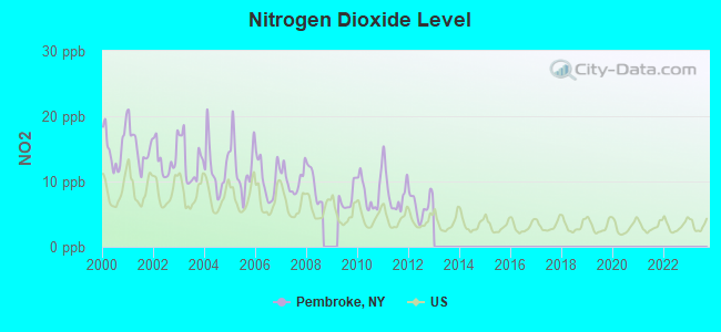
Nitrogen Dioxide (NO2) [ppb] level in 2012 was 6.43. This is worse than average. Closest monitor was 19.3 miles away from the city center.
| City: | 6.43 |
| U.S.: | 5.11 |
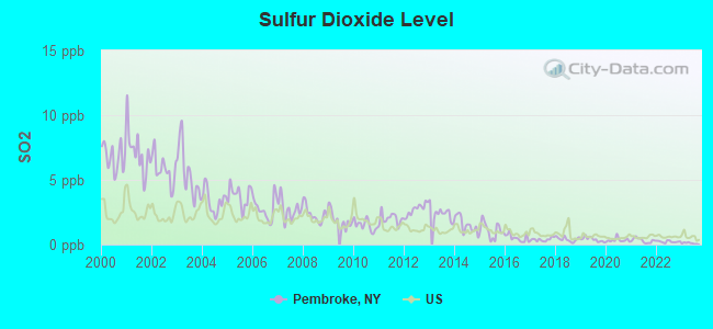
Sulfur Dioxide (SO2) [ppb] level in 2023 was 0.107. This is significantly better than average. Closest monitor was 5.3 miles away from the city center.
| City: | 0.107 |
| U.S.: | 1.515 |
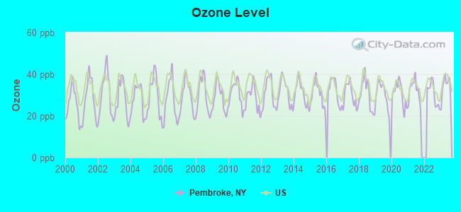
Ozone [ppb] level in 2023 was 33.8. This is about average. Closest monitor was 19.3 miles away from the city center.
| City: | 33.8 |
| U.S.: | 33.3 |
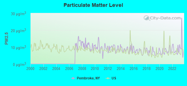
Particulate Matter (PM2.5) [µg/m3] level in 2023 was 10.6. This is worse than average. Closest monitor was 19.3 miles away from the city center.
| City: | 10.6 |
| U.S.: | 8.1 |
Tornado activity:
Pembroke-area historical tornado activity is below New York state average. It is 77% smaller than the overall U.S. average.
On 8/19/1970, a category F3 (max. wind speeds 158-206 mph) tornado 30.9 miles away from the Pembroke town center injured 3 people and caused between $50,000 and $500,000 in damages.
On 8/23/1971, a category F2 (max. wind speeds 113-157 mph) tornado 13.7 miles away from the town center caused between $5000 and $50,000 in damages.
Earthquake activity:
Pembroke-area historical earthquake activity is significantly above New York state average. It is 68% smaller than the overall U.S. average.On 9/25/1998 at 19:52:52, a magnitude 5.2 (4.8 MB, 4.3 MS, 5.2 LG, 4.5 MW, Depth: 3.1 mi, Class: Moderate, Intensity: VI - VII) earthquake occurred 145.8 miles away from the city center
On 10/7/1983 at 10:18:46, a magnitude 5.3 (5.1 MB, 5.3 LG, 5.1 ML) earthquake occurred 213.9 miles away from the city center
On 1/31/1986 at 16:46:43, a magnitude 5.0 (5.0 MB) earthquake occurred 171.0 miles away from the city center
On 4/20/2002 at 10:50:47, a magnitude 5.3 (5.3 ML, Depth: 3.0 mi) earthquake occurred 257.1 miles away from the city center
On 8/23/2011 at 17:51:04, a magnitude 5.8 (5.8 MW, Depth: 3.7 mi) earthquake occurred 352.0 miles away from the city center
On 4/20/2002 at 10:50:47, a magnitude 5.2 (5.2 MB, 4.2 MS, 5.2 MW, 5.0 MW) earthquake occurred 255.5 miles away from the city center
Magnitude types: regional Lg-wave magnitude (LG), body-wave magnitude (MB), local magnitude (ML), surface-wave magnitude (MS), moment magnitude (MW)
Natural disasters:
The number of natural disasters in Genesee County (18) is near the US average (15).Major Disasters (Presidential) Declared: 9
Emergencies Declared: 9
Causes of natural disasters: Floods: 5, Snowstorms: 5, Storms: 4, Winter Storms: 4, Hurricanes: 2, Blizzard: 1, Ice Storm: 1, Power Outage: 1, Wind: 1, Other: 2 (Note: some incidents may be assigned to more than one category).

Hospitals and medical centers near Pembroke:
- ERIE CO HOME INFIRMARY (Nursing Home, about 10 miles away; ALDEN, NY)
- ERIE COUNTY HOME (Nursing Home, about 10 miles away; ALDEN, NY)
- WESTERN N Y S VETERANS HOME (Nursing Home, about 10 miles away; BATAVIA, NY)
- BROTHERS OF MERCY NURSING AND REHABILITATION CENTER (Nursing Home, about 11 miles away; CLARENCE, NY)
- ST JEROME HOSPITAL (Hospital, about 11 miles away; BATAVIA, NY)
- ST LUKE MANOR OF BATAVIA (Nursing Home, about 11 miles away; BATAVIA, NY)
- BATAVIA NURSING HOME L L C (Nursing Home, about 11 miles away; BATAVIA, NY)
Colleges/universities with over 2000 students nearest to Pembroke:
- Genesee Community College (about 13 miles; Batavia, NY; Full-time enrollment: 4,290)
- Daemen College (about 21 miles; Amherst, NY; FT enrollment: 2,365)
- University at Buffalo (about 21 miles; Buffalo, NY; FT enrollment: 25,415)
- Bryant & Stratton College-Online (about 24 miles; Orchard Park, NY; FT enrollment: 2,212)
- Canisius College (about 24 miles; Buffalo, NY; FT enrollment: 4,376)
- Medaille College (about 24 miles; Buffalo, NY; FT enrollment: 2,361)
- Buffalo State SUNY (about 26 miles; Buffalo, NY; FT enrollment: 10,439)
Public elementary/middle school in Pembroke:
- PEMBROKE PRIMARY SCHOOL (Students: 259, Location: 2486 MAIN RD, Grades: KG-2)
Points of interest:
Notable locations in Pembroke: Fentons Berry Farm (A), Williams Poultry Farm (B), Northland Farm (C), Pembroke Station (D), Pembroke Toll Plaza (E), Pembroke Eastbound Rest Area (F), Camp Wakpala (G), Corfu Fire Department (H), Indian Falls Fire Department (I), Delre's Greenhouse (J), Francis Greenhouse (K). Display/hide their locations on the map
Churches in Pembroke include: Corfu Presbyterian Church (A), High Point Church (B), Indian Falls Methodist Church (C), Saint Francis of Assisi Church (D), Mogadore Chapel (E). Display/hide their locations on the map
Cemeteries: Indian Falls Cemetery (1), Evergreen Hill Cemetery (2), Old Buffalo Road Cemetery (3), North Pembroke Cemetery (4), Hillside Cemetery (5). Display/hide their locations on the map
| This town: | 2.5 people |
| New York: | 2.6 people |
| This town: | 72.0% |
| Whole state: | 63.5% |
| This town: | 7.1% |
| Whole state: | 6.8% |
Likely homosexual households (counted as self-reported same-sex unmarried-partner households)
- Lesbian couples: 0.2% of all households
- Gay men: 0.2% of all households
| This town: | 4.8% |
| Whole state: | 14.6% |
| This town: | 0.7% |
| Whole state: | 7.4% |
For population 15 years and over in Pembroke:
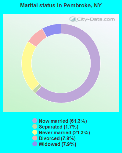
- Never married: 21.3%
- Now married: 61.3%
- Separated: 1.7%
- Widowed: 7.9%
- Divorced: 7.8%
For population 25 years and over in Pembroke:
- High school or higher: 84.7%
- Bachelor's degree or higher: 15.2%
- Graduate or professional degree: 5.6%
- Unemployed: 3.8%
- Mean travel time to work (commute): 28.0 minutes
| Here: | 9.3 |
| New York average: | 14.2 |
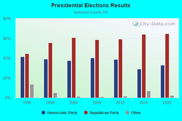
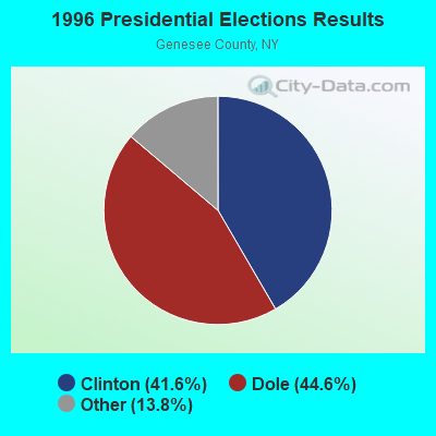
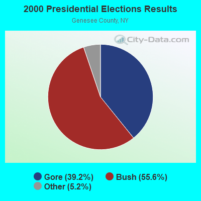
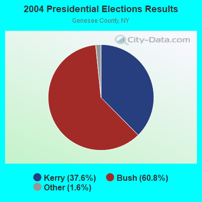
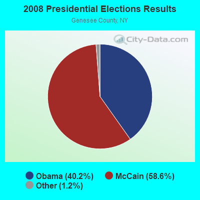
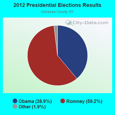
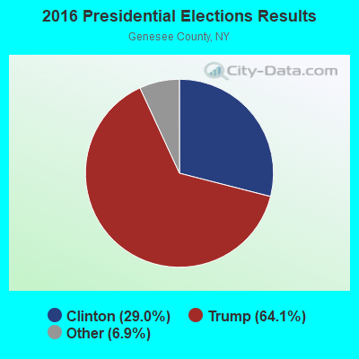
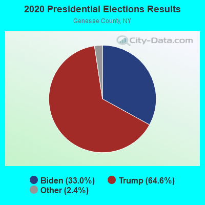
Graphs represent county-level data. Detailed 2008 Election Results
Religion statistics for Pembroke, NY (based on Genesee County data)
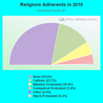
| Religion | Adherents | Congregations |
|---|---|---|
| Catholic | 15,455 | 9 |
| Mainline Protestant | 6,000 | 37 |
| Evangelical Protestant | 4,468 | 27 |
| Other | 321 | 3 |
| Black Protestant | 179 | 1 |
| None | 33,656 | - |
Food Environment Statistics:
| This county: | 1.72 / 10,000 pop. |
| New York: | 4.13 / 10,000 pop. |
| This county: | 0.17 / 10,000 pop. |
| New York: | 0.06 / 10,000 pop. |
| This county: | 0.52 / 10,000 pop. |
| New York: | 0.92 / 10,000 pop. |
| This county: | 4.64 / 10,000 pop. |
| New York: | 1.68 / 10,000 pop. |
| Here: | 8.26 / 10,000 pop. |
| New York: | 8.82 / 10,000 pop. |
| Genesee County: | 8.6% |
| New York: | 8.2% |
| Genesee County: | 27.3% |
| New York: | 23.8% |
| This county: | 16.2% |
| State: | 15.6% |
Businesses in Pembroke, NY
- FedEx: 1
Strongest AM radio stations in Pembroke:
- WWKB (1520 AM; 50 kW; BUFFALO, NY; Owner: ENTERCOM BUFFALO LICENSE, LLC)
- WHAM (1180 AM; 50 kW; ROCHESTER, NY; Owner: CITICASTERS LICENSES, L.P.)
- WXRL (1300 AM; 5 kW; LANCASTER, NY; Owner: DOME BROADCASTING, INC.)
- WGR (550 AM; 5 kW; BUFFALO, NY; Owner: ENTERCOM BUFFALO LICENSE, LLC)
- WTOR (770 AM; daytime; 9 kW; YOUNGSTOWN, NY; Owner: BIRACH BROADCASTING CORPORATION)
- WBTA (1490 AM; 1 kW; BATAVIA, NY; Owner: BRO-BEN COMMUNICATIONS, INC.)
- WBEN (930 AM; 5 kW; BUFFALO, NY; Owner: ENTERCOM BUFFALO LICENSE, LLC)
- WNED (970 AM; 5 kW; BUFFALO, NY)
- WLGZ (990 AM; 5 kW; ROCHESTER, NY; Owner: KIMTRON, INC.)
- WHLD (1270 AM; 5 kW; NIAGARA FALLS, NY; Owner: CITADEL BROADCASTING COMPANY)
- WCJW (1140 AM; daytime; 2 kW; WARSAW, NY; Owner: LLOYD LANE, INCORPORATED)
- WJJL (1440 AM; 5 kW; NIAGARA FALLS, NY; Owner: M.J. PHILLIPS COMMUNICATIONS, INC.)
- WHTK (1280 AM; 5 kW; ROCHESTER, NY)
Strongest FM radio stations in Pembroke:
- WLOF (101.7 FM; ATTICA, NY; Owner: HOLY FAMILY COMMUNICATIONS, INC.)
- WTSS (102.5 FM; BUFFALO, NY; Owner: ENTERCOM BUFFALO LICENSE, LLC)
- WCOU (88.3 FM; WARSAW, NY; Owner: FAMILY LIFE MINISTRIES, INC.)
- WGRF (96.9 FM; BUFFALO, NY; Owner: CITADEL BROADCASTING COMPANY)
- WNSA (107.7 FM; WETHERSFIELD TWNSHP, NY; Owner: ADELPHIA COMMUNICATIONS CORPORATION, DEBTOR-IN-POSSESSION)
- DW208AM (89.5 FM; BATAVIA, NY; Owner: AMERICAN FAMILY ASSOCIATION)
- WNED-FM (94.5 FM; BUFFALO, NY; Owner: WESTERN NEW YORK PUBLIC B/C ASSOC.)
- WBUF (92.9 FM; BUFFALO, NY; Owner: INFINITY RADIO OPERATIONS INC.)
- WBLK (93.7 FM; DEPEW, NY; Owner: INFINITY RADIO OPERATIONS INC.)
- WJYE (96.1 FM; BUFFALO, NY; Owner: INFINITY RADIO OPERATIONS INC.)
- WDCX (99.5 FM; BUFFALO, NY; Owner: KIMTRON, INC.)
- WMJQ (105.5 FM; BROCKPORT, NY; Owner: CANANDAIGUA BROADCASTING, INC.)
- WYRK (106.5 FM; BUFFALO, NY; Owner: INFINITY RADIO OPERATIONS INC.)
- WJCA (102.1 FM; ALBION, NY; Owner: CSN INTERNATIONAL)
- WHTT-FM (104.1 FM; BUFFALO, NY; Owner: CITADEL BROADCASTING COMPANY)
- WGCC-FM (90.7 FM; BATAVIA, NY; Owner: GENESEE COMMUNITY COLLEGE)
- WFBF (89.9 FM; BUFFALO, NY; Owner: FAMILY STATIONS, INC.)
- WEDG (103.3 FM; BUFFALO, NY; Owner: CITADEL BROADCASTING COMPANY)
- WBFO (88.7 FM; BUFFALO, NY; Owner: STATE UNIVERSITY OF NEW YORK)
TV broadcast stations around Pembroke:
- WNYO-TV (Channel 49; BUFFALO, NY; Owner: NEW YORK TELEVISION, INC.)
- WGRZ-TV (Channel 2; BUFFALO, NY; Owner: MULTIMEDIA ENTERTAINMENT, INC.)
- WPXJ-TV (Channel 51; BATAVIA, NY; Owner: PAXSON BUFFALO LICENSE, INC.)
- WKBW-TV (Channel 7; BUFFALO, NY; Owner: WKBW-TV LICENSE, INC.)
- WIVB-TV (Channel 4; BUFFALO, NY; Owner: WIVB BROADCASTING, LLC)
- WNED-TV (Channel 17; BUFFALO, NY; Owner: WESTERN NY PUBLIC BROADCASTING ASSOC.)
- WUTV (Channel 29; BUFFALO, NY; Owner: WUTV LICENSEE, LLC)
- WNLO (Channel 23; BUFFALO, NY; Owner: WIVB BROADCASTING, LLC)
- WDTB-LP (Channel 39; HAMBURG, NY; Owner: WORD OF GOD FELLOWSHIP, INC.)
- WFHW-LP (Channel 58; BUFFALO, NY; Owner: CITIZENS TELEVISION SYSTEM, INC.)
- WBXZ-LP (Channel 56; BUFFALO, NY; Owner: RENARD COMMUNICATIONS CORP.)
- WNGS (Channel 67; SPRINGVILLE, NY; Owner: CAROLINE K. POWLEY D/B/A UNICORN/SPRINGVILLE)
- WBNF-CA (Channel 15; BUFFALO, NY; Owner: FAITH BROADCASTING NETWORK, INC.)
- National Bridge Inventory (NBI) Statistics
- 28Number of bridges
- 249ft / 76.2mTotal length
- $51,208,000Total costs
- 242,667Total average daily traffic
- 49,940Total average daily truck traffic
- New bridges - historical statistics
- 11910-1919
- 31930-1939
- 11940-1949
- 131950-1959
- 11960-1969
- 11970-1979
- 11980-1989
- 41990-1999
- 22000-2009
- 12010-2019
FCC Registered Cell Phone Towers:
1 (See the full list of FCC Registered Cell Phone Towers in Pembroke)FCC Registered Antenna Towers:
20 (See the full list of FCC Registered Antenna Towers)FCC Registered Private Land Mobile Towers:
2- I90 M P 401.72 Plaza 48a (Lat: 43.003111 Lon: -78.407250), Type: Building, Structure height: 5 m, Call Sign: WPHU802, Licensee ID: L00151007,
Assigned Frequencies: 915.000 MHz, Grant Date: 04/17/2015, Expiration Date: 07/14/2025, Registrant: New York State Thruway Authority, 200 Southern Blvd, Bldg 11, Albany, NY 12209, Phone: (518) 471-4436, Fax: (518) 436-3068, Email:
- Exit 48a Overpass On I 90 @ Mile Post 401.3 (Lat: 43.007194 Lon: -78.405417), Type: Bridg, Structure height: 5 m, Overall height: 11 m, Call Sign: WPXJ974, Licensee ID: L00151007,
Assigned Frequencies: 915.000 MHz, Grant Date: 02/22/2023, Expiration Date: 04/21/2033, Certifier: Roy V Sifert, Registrant: New York State Thruway Authority, 200 Southern Blvd, Bldg 11, Albany, NY 12209, Phone: (518) 471-4436, Fax: (518) 436-3068, Email:
2002 - 2018 National Fire Incident Reporting System (NFIRS) incidents
- Fire incident types reported to NFIRS in Pembroke, NY
- 11347.1%Structure Fires
- 6627.5%Mobile Property/Vehicle Fires
- 3815.8%Outside Fires
- 239.6%Other
 According to the data from the years 2002 - 2018 the average number of fire incidents per year is 14. The highest number of fires - 45 took place in 2017, and the least - 0 in 2003. The data has a growing trend.
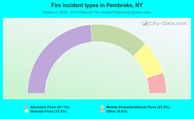 When looking into fire subcategories, the most incidents belonged to: Structure Fires (47.1%), and Mobile Property/Vehicle Fires (27.5%).
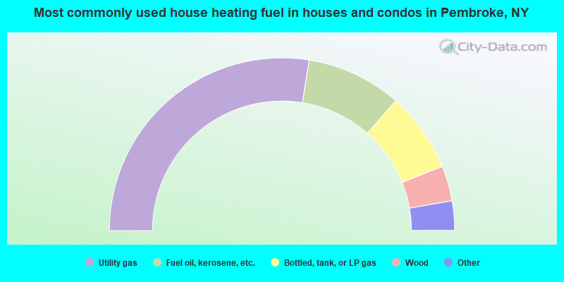
- 55.1%Utility gas
- 17.9%Fuel oil, kerosene, etc.
- 15.0%Bottled, tank, or LP gas
- 6.6%Wood
- 3.6%Electricity
- 1.4%No fuel used
- 0.5%Other fuel
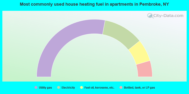
- 55.9%Utility gas
- 22.6%Electricity
- 12.4%Fuel oil, kerosene, etc.
- 9.1%Bottled, tank, or LP gas
Pembroke compared to New York state average:
- Median house value significantly below state average.
- Unemployed percentage significantly below state average.
- Black race population percentage significantly below state average.
- Hispanic race population percentage significantly below state average.
- Foreign-born population percentage significantly below state average.
- Renting percentage significantly below state average.
- Length of stay since moving in significantly above state average.
- Number of rooms per house significantly below state average.
- House age significantly below state average.
- Percentage of population with a bachelor's degree or higher below state average.
State forum archive:
- New York Pages: 2 3 4 5 6 7 8 9 10 11 12 13 14 15 16 17 18 19 20 21 22 23 24 25 26 27 28 29 30 31 32 33 34 35 36 37 38 39
- Albany area Pages: 2 3 4 5 6 7 8 9 10 11
- Buffalo area Pages: 2 3 4 5 6 7 8 9 10 11 12 13 14 15 16 17 18
- Long Island Pages: 2 3 4 5 6 7 8 9 10 11 12 13 14 15 16 17 18 19 20 21 22 23 24 25 26 27 28 29 30 31 32 33 34 35 36 37 38 39 40 41 42 43 44 45 46 47 48 49 50 51 52 53 54 55 56 57 58 59 60 61 62 63 64 65 66 67 68 69 70 71 72 73 74 75 76 77 78 79 80 81 82 83 84 85 86 87 88 89 90 91 92 93 94 95 96 97 98 99 100 101 102 103 104 105 106 107 108 109 110 111 112 113 114 115 116 117 118
- New York City Pages: 2 3 4 5 6 7 8 9 10 11 12 13 14 15 16 17 18 19 20 21 22 23 24 25 26 27 28 29 30 31 32 33 34 35 36 37 38 39 40 41 42 43 44 45 46 47 48 49 50 51 52 53 54 55 56 57 58 59 60 61 62 63 64 65 66 67 68 69 70 71 72 73 74 75 76 77 78 79 80 81 82 83 84 85 86 87 88 89 90 91 92 93 94 95 96 97 98 99 100 101 102 103 104 105 106 107 108 109 110 111 112 113 114 115 116 117 118 119 120 121 122 123 124 125 126 127 128 129 130 131 132 133 134 135 136 137 138 139 140 141 142 143 144 145 146 147 148 149 150 151 152 153 154 155 156 157 158 159 160 161 162 163 164 165 166 167 168 169 170 171 172 173 174 175 176 177 178 179 180 181 182 183 184 185 186 187 188 189 190 191 192 193 194 195 196 197 198 199 200 201 202 203 204 205 206 207 208 209 210 211 212 213 214 215 216 217 218 219 220 221 222 223 224 225 226 227 228 229 230 231 232 233 234 235 236 237 238 239 240
- Rochester area Pages: 2 3 4 5 6 7 8 9 10 11 12 13
- Syracuse area Pages: 2 3 4 5 6 7 8 9 10 11 12
- Westchester County Pages: 2 3 4 5 6 7 8 9 10 11 12 13 14 15 16 17 18 19 20 21 22 23 24 25 26 27 28 29 30 31 32 33 34