Bridge Statistics for Anaheim, California (CA)
Condition, Traffic, Stress, Structural Evaluation, Project Costs
- National Bridge Inventory (NBI) Statistics
- 285Number of bridges
- 4,925ft / 1,501mTotal length
- $11,835,000Total costs
- 26,273,322Total average daily traffic
- 1,612,373Total average daily truck traffic
- National Bridge Inventory (NBI) Registered Bridges for Anaheim
- No street view available for this location
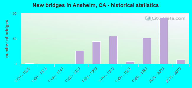
- New bridges - historical statistics
- 11920-1929
- 261950-1959
- 451960-1969
- 551970-1979
- 51980-1989
- 521990-1999
- 922000-2009
- 92010-2019
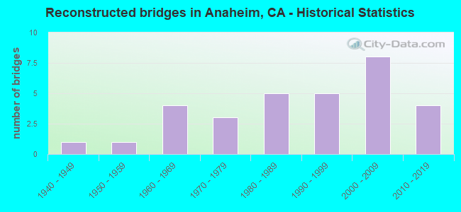
- Reconstructed bridges - Historical Statistics
- 11940-1949
- 11950-1959
- 41960-1969
- 31970-1979
- 51980-1989
- 51990-1999
- 82000-2009
- 42010-2019
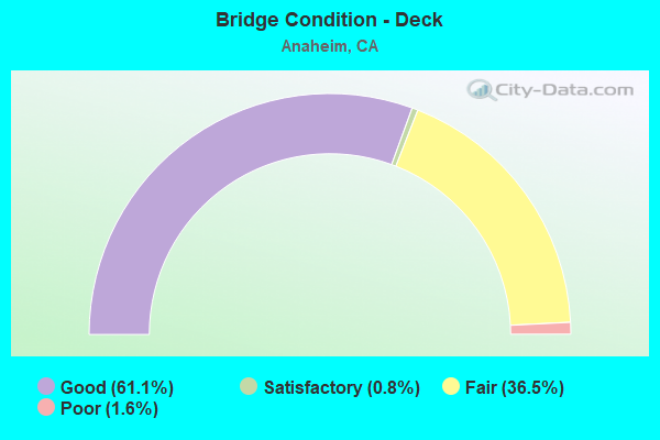
- Bridge Condition - Deck
- 61.1%Good
- 0.8%Satisfactory
- 36.5%Fair
- 1.6%Poor
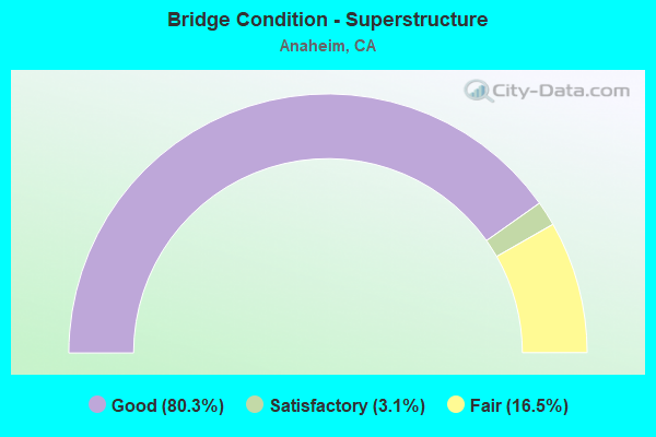
- Bridge Condition - Superstructure
- 80.3%Good
- 3.1%Satisfactory
- 16.5%Fair
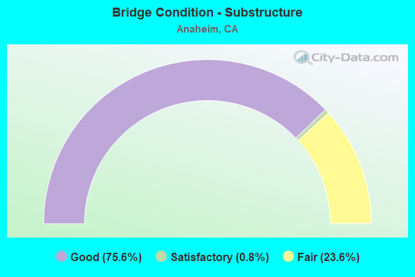
- Bridge Condition - Substructure
- 75.6%Good
- 0.8%Satisfactory
- 23.6%Fair
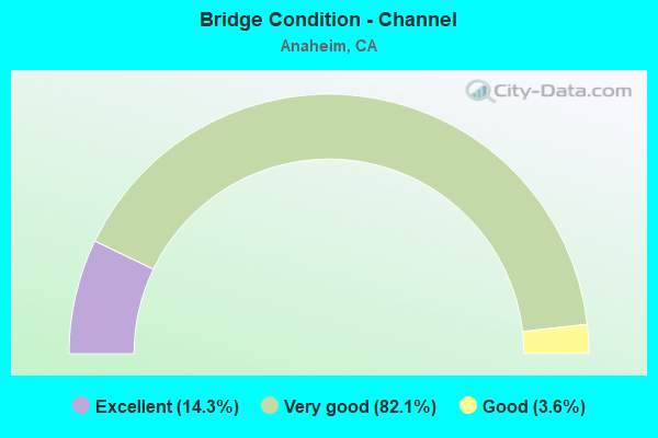
- Bridge Condition - Channel
- 14.3%Excellent
- 82.1%Very good
- 3.6%Good
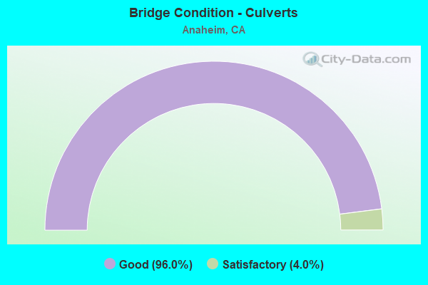
- Bridge Condition - Culverts
- 96.0%Good
- 4.0%Satisfactory
Find on map >> Show street view
Structure Number: 55 0505L, Location: 12-ORA-091-R14.43L (Lat: 33.870503, Lng: -117.744956), Route carried "on" structure: State highway 91, Year Built: 1971, Year Reconstructed: 1996, Status: Open, Structure Length: 4.63m (15.19ft), Average Daily Traffic: 96,000 (year 2012), Average Future Daily Traffic: 176,054 (year 2040), Design Load: HS 20, Features Intersected: WEIR CANYON RD
Minimum Vertical Clearance: 30+ m (98+ ft), Kilometerpoint: 14.430, Lanes on structure: 8, Lanes under structure: 6, Base Highway Network: Yes (, Subroute: 1), Owner: State Highway Agency, Approaching Roadway Width: 46.3m (151.9ft), Skew: 31 degrees, Material/Design: Concrete continuous, Design/Construction: Box Beam or Girders - Multiple, Number Of Spans In Main Unit: 2, Length of Maximum Span: 22.9m (75.1ft), Curb-To-Curb Width: 46.3m (151.9ft), Out-to-Out Width: 47.3m (155.2ft)
Condition: Deck: Fair, Superstructure: Good, Substructure: Fair, Operating Rating: 54.1 metric tons, Method Used To Determine Operating Rating: Assigned rating based on Load Factor Design (LFD) reported in metric tons, Inventory Rating: 32.4 metric tons, Method Used To Determine Inventory Rating: Assigned rating based on Load Factor Design (LFD) reported in metric tons, Structural Evaluation: Somewhat better than minimum adequacy, Deck Geometry: Superior to present desirable criteria, Underclear: High priority of corrective action, Approach Roadway Alignment: Equal to present desirable criteria, Designated Inspection Frequency: Every 24 months, Inspection Date: November 2021, Deck Structure Type: Concrete Cast-file-Place
Find on map >> Show street view
Structure Number: 55 0505R, Location: 12-ORA-091-R14.43R (Lat: 33.870019, Lng: -117.744639), Route carried "on" structure: State highway 91, Year Built: 1971, Year Reconstructed: 1996, Status: Open, Structure Length: 4.75m (15.58ft), Average Daily Traffic: 96,000 (year 2014), Average Future Daily Traffic: 176,054 (year 2040), Design Load: HS 20, Features Intersected: WEIR CANYON RD
Minimum Vertical Clearance: 30+ m (98+ ft), Kilometerpoint: 14.430, Lanes on structure: 8, Lanes under structure: 6, Base Highway Network: Yes (, Subroute: 1), Owner: State Highway Agency, Approaching Roadway Width: 53.2m (174.5ft), Skew: 2 degrees, Material/Design: Concrete continuous, Design/Construction: Box Beam or Girders - Multiple, Number Of Spans In Main Unit: 2, Length of Maximum Span: 24.1m (79.1ft), Curb or Sidewalk Widths: Left: 2.7m (8.9ft), Right: 0.0m, Curb-To-Curb Width: 53.2m (174.5ft), Out-to-Out Width: 54.2m (177.8ft)
Condition: Deck: Good, Superstructure: Good, Substructure: Fair, Operating Rating: 54.1 metric tons, Method Used To Determine Operating Rating: Assigned rating based on Load Factor Design (LFD) reported in metric tons, Inventory Rating: 32.4 metric tons, Method Used To Determine Inventory Rating: Assigned rating based on Load Factor Design (LFD) reported in metric tons, Structural Evaluation: Somewhat better than minimum adequacy, Deck Geometry: Superior to present desirable criteria, Underclear: High priority of corrective action, Approach Roadway Alignment: Equal to present desirable criteria, Designated Inspection Frequency: Every 24 months, Inspection Date: November 2021, Deck Structure Type: Concrete Cast-file-Place
Find on map >> Show street view
Structure Number: 55 0506, Location: 12-ORA-091-R16.40-ANA (Lat: 33.866539, Lng: -117.711592), Route carried "on" structure: State highway 91, Year Built: 1971, Year Reconstructed: 1994, Status: Open, Structure Length: 3.93m (12.89ft), Average Daily Traffic: 263,000 (year 2012), Truck Traffic: 8%, Average Future Daily Traffic: 328,000 (year 2040), Design Load: HS 20, Features Intersected: GYPSUM CANYON RD
Minimum Vertical Clearance: 30+ m (98+ ft), Kilometerpoint: 16.400, Lanes on structure: 14, Lanes under structure: 3, Base Highway Network: Yes (, Subroute: 1), Owner: State Highway Agency, Approaching Roadway Width: 66.9m (219.5ft), Skew: 30 degrees, Material/Design: Prestressed concrete, Design/Construction: Box Beam or Girders - Multiple, Number Of Spans In Main Unit: 1, Length of Maximum Span: 38.1m (125.0ft), Curb-To-Curb Width: 66.9m (219.5ft), Out-to-Out Width: 69.5m (228.0ft)
Condition: Deck: Fair, Superstructure: Good, Substructure: Good, Operating Rating: 54.1 metric tons, Method Used To Determine Operating Rating: Assigned rating based on Load Factor Design (LFD) reported in metric tons, Inventory Rating: 32.4 metric tons, Method Used To Determine Inventory Rating: Assigned rating based on Load Factor Design (LFD) reported in metric tons, Structural Evaluation: Better than present minimum criteria, Deck Geometry: Superior to present desirable criteria, Underclear: Equal to present minimum criteria, Approach Roadway Alignment: Equal to present desirable criteria, Designated Inspection Frequency: Every 24 months, Inspection Date: November 2021, Deck Structure Type: Concrete Cast-file-Place
Find on map >> Show street view
Structure Number: 55 0515, Location: 12-ORA-057-13.92-ANA (Lat: 33.825297, Lng: -117.876456), Route carried "on" structure: City street , Year Built: 1974, Status: Open, Structure Length: 6.46m (21.19ft), Average Daily Traffic: 5,000 (year 2011), Truck Traffic: 1%, Average Future Daily Traffic: 6,018 (year 2044), Design Load: HS 20, Features Intersected: STATE ROUTE 57, Facility Carried by Structure: WAGNER AVE
Minimum Vertical Clearance: 30+ m (98+ ft), Kilometerpoint: 0.000, Lanes on structure: 4, Lanes under structure: 11, Owner: State Highway Agency, Approaching Roadway Width: 19.5m (64.0ft), Material/Design: Concrete continuous, Design/Construction: Box Beam or Girders - Multiple, Number Of Spans In Main Unit: 2, Length of Maximum Span: 32.0m (105.0ft), Curb or Sidewalk Widths: Left: 2.1m (6.9ft), Right: 2.1m (6.9ft), Curb-To-Curb Width: 19.5m (64.0ft), Out-to-Out Width: 24.4m (80.1ft)
Condition: Deck: Good, Superstructure: Satisfactory, Substructure: Good, Operating Rating: 58.3 metric tons, Method Used To Determine Operating Rating: Load and Resistance Factor Rating (LRFR) rating reported by rating factor(RF) method using HL-93 loadings, Inventory Rating: 45.0 metric tons, Method Used To Determine Inventory Rating: Load and Resistance Factor Rating (LRFR) rating reported by rating factor(RF) method using HL-93 loadings, Structural Evaluation: Equal to present minimum criteria, Deck Geometry: Better than present minimum criteria, Underclear: Meets minimum limits, Approach Roadway Alignment: Equal to present desirable criteria, Designated Inspection Frequency: Every 24 months, Inspection Date: January 2022, Deck Structure Type: Concrete Cast-file-Place
Find on map >> Show street view
Structure Number: 55 0516, Location: 12-ORA-057-14.42-ANA (Lat: 33.832561, Lng: -117.876472), Route carried "on" structure: City street , Year Built: 1974, Status: Open, Structure Length: 6.83m (22.41ft), Average Daily Traffic: 10,000 (year 2011), Truck Traffic: 3%, Average Future Daily Traffic: 12,034 (year 2044), Design Load: HS 20, Features Intersected: STATE ROUTE 57, Facility Carried by Structure: SOUTH STREET
Minimum Vertical Clearance: 30+ m (98+ ft), Kilometerpoint: 0.000, Lanes on structure: 4, Lanes under structure: 11, Owner: State Highway Agency, Approaching Roadway Width: 19.5m (64.0ft), Material/Design: Concrete continuous, Design/Construction: Box Beam or Girders - Multiple, Number Of Spans In Main Unit: 2, Length of Maximum Span: 33.8m (110.9ft), Curb or Sidewalk Widths: Left: 2.1m (6.9ft), Right: 2.1m (6.9ft), Curb-To-Curb Width: 19.5m (64.0ft), Out-to-Out Width: 24.4m (80.1ft)
Condition: Deck: Good, Superstructure: Satisfactory, Substructure: Good, Operating Rating: 68.7 metric tons, Method Used To Determine Operating Rating: Load and Resistance Factor Rating (LRFR) rating reported by rating factor(RF) method using HL-93 loadings, Inventory Rating: 52.8 metric tons, Method Used To Determine Inventory Rating: Load and Resistance Factor Rating (LRFR) rating reported by rating factor(RF) method using HL-93 loadings, Structural Evaluation: Equal to present minimum criteria, Deck Geometry: Better than present minimum criteria, Underclear: Equal to present minimum criteria, Approach Roadway Alignment: Equal to present desirable criteria, Designated Inspection Frequency: Every 24 months, Inspection Date: January 2022, Deck Structure Type: Concrete Cast-file-Place
Find on map >> Show street view
Structure Number: 55 0524, Location: 12-ORA-057-13.42-ANA (Lat: 33.817953, Lng: -117.876697), Route carried "on" structure: City street L060, Year Built: 1974, Status: Open, Structure Length: 7.28m (23.88ft), Average Daily Traffic: 15,000 (year 2011), Truck Traffic: 3%, Average Future Daily Traffic: 18,052 (year 2044), Design Load: HS 20, Features Intersected: STATE ROUTE 57, Facility Carried by Structure: BALL RD
Minimum Vertical Clearance: 30+ m (98+ ft), Kilometerpoint: 0.000, Lanes on structure: 6, Lanes under structure: 12, Base Highway Network: Yes, Owner: State Highway Agency, Approaching Roadway Width: 26.2m (86.0ft), Skew: 20 degrees, Material/Design: Concrete continuous, Design/Construction: Box Beam or Girders - Multiple, Number Of Spans In Main Unit: 2, Length of Maximum Span: 36.3m (119.1ft), Curb or Sidewalk Widths: Left: 2.1m (6.9ft), Right: 2.1m (6.9ft), Curb-To-Curb Width: 26.2m (86.0ft), Out-to-Out Width: 31.1m (102.0ft)
Condition: Deck: Satisfactory, Superstructure: Satisfactory, Substructure: Good, Operating Rating: 47.3 metric tons, Method Used To Determine Operating Rating: Load and Resistance Factor Rating (LRFR) rating reported by rating factor(RF) method using HL-93 loadings, Inventory Rating: 36.6 metric tons, Method Used To Determine Inventory Rating: Load and Resistance Factor Rating (LRFR) rating reported by rating factor(RF) method using HL-93 loadings, Structural Evaluation: Equal to present minimum criteria, Deck Geometry: Equal to present minimum criteria, Underclear: Equal to present minimum criteria, Approach Roadway Alignment: Equal to present desirable criteria, Designated Inspection Frequency: Every 24 months, Inspection Date: January 2022, Deck Structure Type: Concrete Cast-file-Place
Find on map >> Show street view
Structure Number: 55 0525, Location: 12-ORA-057-14.78-ANA (Lat: 33.837761, Lng: -117.876494), Route carried "on" structure: City street L031, Year Built: 1974, Status: Open, Structure Length: 7.71m (25.30ft), Average Daily Traffic: 20,000 (year 2011), Truck Traffic: 3%, Average Future Daily Traffic: 24,068 (year 2044), Design Load: HS 20, Features Intersected: STATE ROUTE 57, Facility Carried by Structure: LINCOLN AVE
Minimum Vertical Clearance: 30+ m (98+ ft), Kilometerpoint: 0.000, Lanes on structure: 6, Lanes under structure: 13, Base Highway Network: Yes, Owner: State Highway Agency, Approaching Roadway Width: 26.2m (86.0ft), Skew: 21 degrees, Material/Design: Concrete continuous, Design/Construction: Box Beam or Girders - Multiple, Number Of Spans In Main Unit: 2, Length of Maximum Span: 38.4m (126.0ft), Curb or Sidewalk Widths: Left: 2.1m (6.9ft), Right: 2.1m (6.9ft), Curb-To-Curb Width: 26.2m (86.0ft), Out-to-Out Width: 31.1m (102.0ft)
Condition: Deck: Good, Superstructure: Fair, Substructure: Good, Operating Rating: 81.0 metric tons, Method Used To Determine Operating Rating: Load and Resistance Factor Rating (LRFR) rating reported by rating factor(RF) method using HL-93 loadings, Inventory Rating: 62.5 metric tons, Method Used To Determine Inventory Rating: Load and Resistance Factor Rating (LRFR) rating reported by rating factor(RF) method using HL-93 loadings, Structural Evaluation: Somewhat better than minimum adequacy, Deck Geometry: Equal to present minimum criteria, Underclear: Equal to present minimum criteria, Approach Roadway Alignment: Equal to present desirable criteria, Designated Inspection Frequency: Every 24 months, Inspection Date: January 2022, Deck Structure Type: Concrete Cast-file-Place
Find on map >> Show street view
Structure Number: 55 0602K, Location: 12-ORA-057-22.30 (Lat: 33.942892, Lng: -117.873494), Route carried "on" structure: Ramp State highway 57, Year Built: 1971, Status: Open, Structure Length: 1.28m (4.20ft), Average Daily Traffic: 2,260 (year 2010), Truck Traffic: 3%, Average Future Daily Traffic: 2,596 (year 2040), Features Intersected: BREA CANYON CHANNEL
Minimum Vertical Clearance: 30+ m (98+ ft), Kilometerpoint: 22.300, Lanes on structure: 2, Base Highway Network: Yes, Owner: State Highway Agency, Approaching Roadway Width: 15.8m (51.8ft), Skew: 2 degrees, Material/Design: Concrete continuous, Design/Construction: Culvert, Number Of Spans In Main Unit: 3, Length of Maximum Span: 4.3m (14.1ft), Curb-To-Curb Width: 15.8m (51.8ft), Out-to-Out Width: 16.8m (55.1ft)
Condition: Channel: Very good, Culverts: Good, Operating Rating: 54.1 metric tons, Method Used To Determine Operating Rating: Field evaluation and documented engineering judgment, Inventory Rating: 32.4 metric tons, Method Used To Determine Inventory Rating: Field evaluation and documented engineering judgment, Structural Evaluation: Better than present minimum criteria, Deck Geometry: Superior to present desirable criteria, Waterway Adequacy: Equal to present desirable criteria, Approach Roadway Alignment: Equal to present desirable criteria, Designated Inspection Frequency: Every 48 months, Inspection Date: June 2020
Find on map >> Show street view
Structure Number: 55 0604, Location: 12-ORA-091-R10.50-ANA (Lat: 33.853614, Lng: -117.809411), Route carried "on" structure: State highway 91, Year Built: 1970, Status: Open, Structure Length: 0.85m (2.79ft), Average Daily Traffic: 318,000 (year 2012), Truck Traffic: 5%, Average Future Daily Traffic: 368,000 (year 2040), Features Intersected: ROADSIDE DITCH DRAIN 'A'
Minimum Vertical Clearance: 30+ m (98+ ft), Kilometerpoint: 10.500, Lanes on structure: 11, Base Highway Network: Yes (, Subroute: 1), Owner: State Highway Agency, Approaching Roadway Width: 47.5m (155.8ft), Skew: 22 degrees, Material/Design: Concrete continuous, Design/Construction: Culvert, Number Of Spans In Main Unit: 3, Length of Maximum Span: 2.4m (7.9ft), Curb-To-Curb Width: 47.5m (155.8ft), Out-to-Out Width: 48.5m (159.1ft)
Condition: Channel: Very good, Culverts: Good, Operating Rating: 54.1 metric tons, Method Used To Determine Operating Rating: Field evaluation and documented engineering judgment, Inventory Rating: 32.4 metric tons, Method Used To Determine Inventory Rating: Field evaluation and documented engineering judgment, Structural Evaluation: Better than present minimum criteria, Deck Geometry: Better than present minimum criteria, Waterway Adequacy: Equal to present desirable criteria, Approach Roadway Alignment: Equal to present desirable criteria, Designated Inspection Frequency: Every 24 months, Inspection Date: November 2021
Find on map >> Show street view
Structure Number: 55 0605, Location: 12-ORA-091-R11.79-ANA (Lat: 33.855722, Lng: -117.786172), Route carried "on" structure: State highway 91, Year Built: 1970, Status: Open, Structure Length: 0.79m (2.59ft), Average Daily Traffic: 192,000 (year 2011), Truck Traffic: 4%, Average Future Daily Traffic: 363,000 (year 2038), Features Intersected: ROADSIDE DRAIN 'B'
Minimum Vertical Clearance: 30+ m (98+ ft), Kilometerpoint: 11.790, Lanes on structure: 14, Base Highway Network: Yes (, Subroute: 1), Owner: State Highway Agency, Approaching Roadway Width: 58.3m (191.3ft), Skew: 20 degrees, Material/Design: Concrete continuous, Design/Construction: Culvert, Number Of Spans In Main Unit: 3, Length of Maximum Span: 2.4m (7.9ft), Curb-To-Curb Width: 58.3m (191.3ft), Out-to-Out Width: 59.3m (194.6ft)
Condition: Channel: Very good, Culverts: Good, Operating Rating: 54.1 metric tons, Method Used To Determine Operating Rating: Field evaluation and documented engineering judgment, Inventory Rating: 32.4 metric tons, Method Used To Determine Inventory Rating: Field evaluation and documented engineering judgment, Structural Evaluation: Better than present minimum criteria, Deck Geometry: Better than present minimum criteria, Waterway Adequacy: Equal to present desirable criteria, Approach Roadway Alignment: Equal to present desirable criteria, Designated Inspection Frequency: Every 48 months, Inspection Date: November 2019
Find on map >> Show street view
Structure Number: 55 0606, Location: 12-ORA-091-R12.20-ANA (Lat: 33.858653, Lng: -117.780189), Route carried "on" structure: State highway 91, Year Built: 1970, Status: Open, Structure Length: 1.13m (3.71ft), Average Daily Traffic: 192,000 (year 2011), Truck Traffic: 4%, Average Future Daily Traffic: 363,000 (year 2038), Features Intersected: ROADSIDE DRAIN 'C'
Minimum Vertical Clearance: 30+ m (98+ ft), Kilometerpoint: 12.200, Lanes on structure: 13, Base Highway Network: Yes (, Subroute: 1), Owner: State Highway Agency, Approaching Roadway Width: 53.4m (175.2ft), Skew: 20 degrees, Material/Design: Concrete continuous, Design/Construction: Culvert, Number Of Spans In Main Unit: 3, Length of Maximum Span: 3.7m (12.1ft), Curb-To-Curb Width: 53.4m (175.2ft), Out-to-Out Width: 54.4m (178.5ft)
Condition: Channel: Very good, Culverts: Good, Operating Rating: 54.1 metric tons, Method Used To Determine Operating Rating: Field evaluation and documented engineering judgment, Inventory Rating: 32.4 metric tons, Method Used To Determine Inventory Rating: Field evaluation and documented engineering judgment, Structural Evaluation: Better than present minimum criteria, Deck Geometry: Equal to present minimum criteria, Waterway Adequacy: Equal to present desirable criteria, Approach Roadway Alignment: Equal to present desirable criteria, Designated Inspection Frequency: Every 48 months, Inspection Date: November 2019
Find on map >> Show street view
Structure Number: 55 0607, Location: 12-ORA-091-R16.46-ANA (Lat: 33.869525, Lng: -117.704794), Route carried "on" structure: State highway 91, Year Built: 1971, Status: Open, Structure Length: 1.16m (3.81ft), Average Daily Traffic: 263,000 (year 2011), Truck Traffic: 8%, Average Future Daily Traffic: 328,000 (year 2038), Features Intersected: GYPSUM CANYON CREEK
Minimum Vertical Clearance: 30+ m (98+ ft), Kilometerpoint: 16.460, Lanes on structure: 14, Base Highway Network: Yes (, Subroute: 1), Owner: State Highway Agency, Approaching Roadway Width: 56.4m (185.0ft), Skew: 29 degrees, Material/Design: Concrete continuous, Design/Construction: Culvert, Number Of Spans In Main Unit: 3, Length of Maximum Span: 3.7m (12.1ft), Curb-To-Curb Width: 56.4m (185.0ft), Out-to-Out Width: 57.4m (188.3ft)
Condition: Channel: Very good, Culverts: Good, Operating Rating: 54.1 metric tons, Method Used To Determine Operating Rating: Field evaluation and documented engineering judgment, Inventory Rating: 32.4 metric tons, Method Used To Determine Inventory Rating: Field evaluation and documented engineering judgment, Structural Evaluation: Better than present minimum criteria, Deck Geometry: Somewhat better than minimum adequacy, Waterway Adequacy: Equal to present desirable criteria, Approach Roadway Alignment: Equal to present desirable criteria, Designated Inspection Frequency: Every 48 months, Inspection Date: November 2019
Find on map >> Show street view
Structure Number: 55 0608, Location: 12-ORA-091-R17.92R-ANA (Lat: 33.871942, Lng: -117.687889), Route carried "on" structure: State highway 91, Year Built: 1971, Status: Open, Structure Length: 0.63m (2.07ft), Average Daily Traffic: 263,000 (year 2011), Truck Traffic: 8%, Average Future Daily Traffic: 328,000 (year 2038), Features Intersected: COAL CANYON CREEK
Minimum Vertical Clearance: 30+ m (98+ ft), Kilometerpoint: 17.920, Lanes on structure: 14, Base Highway Network: Yes (, Subroute: 1), Owner: State Highway Agency, Approaching Roadway Width: 56.4m (185.0ft), Skew: 29 degrees, Material/Design: Concrete continuous, Design/Construction: Culvert, Number Of Spans In Main Unit: 2, Length of Maximum Span: 3.0m (9.8ft), Curb-To-Curb Width: 56.4m (185.0ft), Out-to-Out Width: 57.4m (188.3ft)
Condition: Channel: Very good, Culverts: Satisfactory, Operating Rating: 54.1 metric tons, Method Used To Determine Operating Rating: Field evaluation and documented engineering judgment, Inventory Rating: 32.4 metric tons, Method Used To Determine Inventory Rating: Field evaluation and documented engineering judgment, Structural Evaluation: Equal to present minimum criteria, Deck Geometry: Somewhat better than minimum adequacy, Waterway Adequacy: Equal to present desirable criteria, Approach Roadway Alignment: Equal to present desirable criteria, Designated Inspection Frequency: Every 48 months, Inspection Date: November 2019
Find on map >> Show street view
Structure Number: 55 0713R, Location: 12-ORA-091-R9.17-ANA (Lat: 33.844144, Lng: -117.827492), Route carried "on" structure: State highway 91, Year Built: 1994, Status: Open, Structure Length: 2.51m (8.23ft), Average Daily Traffic: 106,500 (year 2012), Truck Traffic: 6%, Average Future Daily Traffic: 151,000 (year 2040), Design Load: HS 20+Mod, Features Intersected: W91-S55 CONNECTOR
Minimum Vertical Clearance: 30+ m (98+ ft), Kilometerpoint: 9.170, Lanes on structure: 3, Lanes under structure: 2, Base Highway Network: Yes (, Subroute: 1), Owner: State Highway Agency, Approaching Roadway Width: 14.6m (47.9ft), Skew: 4 degrees, Material/Design: Concrete, Design/Construction: Slab, Number Of Spans In Main Unit: 1, Length of Maximum Span: 25.1m (82.3ft), Curb-To-Curb Width: 14.6m (47.9ft), Out-to-Out Width: 15.6m (51.2ft)
Condition: Deck: Good, Superstructure: Good, Substructure: Good, Operating Rating: 54.1 metric tons, Method Used To Determine Operating Rating: Assigned rating based on Load Factor Design (LFD) reported in metric tons, Inventory Rating: 32.4 metric tons, Method Used To Determine Inventory Rating: Assigned rating based on Load Factor Design (LFD) reported in metric tons, Structural Evaluation: Better than present minimum criteria, Deck Geometry: Meets minimum limits, Underclear: Superior to present desirable criteria, Approach Roadway Alignment: Better than present minimum criteria, Designated Inspection Frequency: Every 24 months, Inspection Date: November 2021, Deck Structure Type: Concrete Cast-file-Place
Find on map >> Show street view
Structure Number: 55 0714, Location: 12-ORA-091-R9.91-ANA (Lat: 33.844367, Lng: -117.826839), Route carried "on" structure: State highway 91, Year Built: 1994, Status: Open, Structure Length: 18.75m (61.52ft), Average Daily Traffic: 96,857 (year 2012), Truck Traffic: 5%, Average Future Daily Traffic: 368,000 (year 2040), Design Load: HS 20+Mod, Features Intersected: W91-S55 CONNECTORS
Minimum Vertical Clearance: 30+ m (98+ ft), Kilometerpoint: 9.910, Lanes on structure: 2, Lanes under structure: 3, Base Highway Network: Yes (, Subroute: 1), Owner: State Highway Agency, Approaching Roadway Width: 13.5m (44.3ft), Skew: 39 degrees, Material/Design: Prestressed concrete continuous, Design/Construction: Box Beam or Girders - Multiple, Number Of Spans In Main Unit: 5, Length of Maximum Span: 37.5m (123.0ft), Curb-To-Curb Width: 13.5m (44.3ft), Out-to-Out Width: 15.1m (49.5ft)
Condition: Deck: Good, Superstructure: Good, Substructure: Fair, Operating Rating: 54.1 metric tons, Method Used To Determine Operating Rating: Assigned rating based on Load Factor Design (LFD) reported in metric tons, Inventory Rating: 32.4 metric tons, Method Used To Determine Inventory Rating: Assigned rating based on Load Factor Design (LFD) reported in metric tons, Structural Evaluation: Somewhat better than minimum adequacy, Deck Geometry: Meets minimum limits, Underclear: High priority of corrective action, Approach Roadway Alignment: Equal to present desirable criteria, Designated Inspection Frequency: Every 24 months, Inspection Date: November 2021, Deck Structure Type: Concrete Cast-file-Place
Find on map >> Show street view
Structure Number: 55 0724L, Location: 12-ORA-241-36.70-ANA (Lat: 33.833978, Lng: -117.717186), Route carried "on" structure: State highway 241, Year Built: 1998, Status: Open, Structure Length: 5.30m (17.39ft), Average Daily Traffic: 22,500 (year 2012), Average Future Daily Traffic: 47,500 (year 2040), Design Load: HS 20+Mod, Features Intersected: WILDLIFE UC
Minimum Vertical Clearance: 30+ m (98+ ft), Kilometerpoint: 36.700, Lanes on structure: 4, Base Highway Network: Yes (Inventory Route: 2, Subroute: 1), Toll: On toll road, Owner: State Highway Agency, Approaching Roadway Width: 20.8m (68.2ft), Material/Design: Prestressed concrete, Design/Construction: Box Beam or Girders - Multiple, Number Of Spans In Main Unit: 1, Length of Maximum Span: 52.0m (170.6ft), Curb-To-Curb Width: 20.8m (68.2ft), Out-to-Out Width: 21.8m (71.5ft)
Condition: Deck: Good, Superstructure: Good, Substructure: Good, Operating Rating: 54.1 metric tons, Method Used To Determine Operating Rating: Assigned rating based on Load Factor Design (LFD) reported in metric tons, Inventory Rating: 32.4 metric tons, Method Used To Determine Inventory Rating: Assigned rating based on Load Factor Design (LFD) reported in metric tons, Structural Evaluation: Better than present minimum criteria, Deck Geometry: Equal to present minimum criteria, Approach Roadway Alignment: Equal to present desirable criteria, Designated Inspection Frequency: Every 24 months, Inspection Date: Febuary 2021, Deck Structure Type: Concrete Cast-file-Place
Find on map >> Show street view
Structure Number: 55 0724R, Location: 12-ORA-241-36.70-ANA (Lat: 33.833917, Lng: -117.717672), Route carried "on" structure: State highway 241, Year Built: 1998, Year Reconstructed: 2009, Status: Open, Structure Length: 5.30m (17.39ft), Average Daily Traffic: 22,500 (year 2012), Average Future Daily Traffic: 47,500 (year 2040), Design Load: HS 20+Mod, Features Intersected: WILDLIFE UC
Minimum Vertical Clearance: 30+ m (98+ ft), Kilometerpoint: 36.700, Lanes on structure: 4, Base Highway Network: Yes (Inventory Route: 2, Subroute: 1), Toll: On toll road, Owner: State Highway Agency, Approaching Roadway Width: 24.0m (78.7ft), Material/Design: Prestressed concrete, Design/Construction: Box Beam or Girders - Multiple, Number Of Spans In Main Unit: 1, Length of Maximum Span: 52.0m (170.6ft), Curb-To-Curb Width: 24.0m (78.7ft), Out-to-Out Width: 25.0m (82.0ft)
Condition: Deck: Fair, Superstructure: Good, Substructure: Fair, Operating Rating: 54.1 metric tons, Method Used To Determine Operating Rating: Assigned rating based on Load Factor Design (LFD) reported in metric tons, Inventory Rating: 32.4 metric tons, Method Used To Determine Inventory Rating: Assigned rating based on Load Factor Design (LFD) reported in metric tons, Structural Evaluation: Somewhat better than minimum adequacy, Deck Geometry: Superior to present desirable criteria, Approach Roadway Alignment: Equal to present desirable criteria, Designated Inspection Frequency: Every 24 months, Inspection Date: Febuary 2021, Deck Structure Type: Concrete Cast-file-Place
Find on map >> Show street view
Structure Number: 55 0786L, Location: 12-ORA-241-34.81-ANA (Lat: 33.807344, Lng: -117.724042), Route carried "on" structure: State highway 241, Year Built: 1998, Status: Open, Structure Length: 7.90m (25.92ft), Average Daily Traffic: 41,000 (year 2012), Truck Traffic: 3%, Average Future Daily Traffic: 49,166 (year 2040), Design Load: HS 20+Mod, Features Intersected: OAK CANYON WILDLIFE
Minimum Vertical Clearance: 30+ m (98+ ft), Kilometerpoint: 34.810, Lanes on structure: 3, Base Highway Network: Yes (Inventory Route: 2, Subroute: 1), Toll: On toll road, Owner: State Highway Agency, Approaching Roadway Width: 17.1m (56.1ft), Material/Design: Prestressed concrete, Design/Construction: Box Beam or Girders - Multiple, Number Of Spans In Main Unit: 1, Length of Maximum Span: 78.0m (255.9ft), Curb-To-Curb Width: 17.1m (56.1ft), Out-to-Out Width: 18.1m (59.4ft)
Condition: Deck: Good, Superstructure: Good, Substructure: Good, Operating Rating: 54.1 metric tons, Method Used To Determine Operating Rating: Assigned rating based on Load Factor Design (LFD) reported in metric tons, Inventory Rating: 32.4 metric tons, Method Used To Determine Inventory Rating: Assigned rating based on Load Factor Design (LFD) reported in metric tons, Structural Evaluation: Better than present minimum criteria, Deck Geometry: Equal to present minimum criteria, Approach Roadway Alignment: Equal to present desirable criteria, Designated Inspection Frequency: Every 24 months, Inspection Date: Febuary 2021, Deck Structure Type: Concrete Cast-file-Place
Find on map >> Show street view
Structure Number: 55 0786R, Location: 12-ORA-241-34.81-ANA (Lat: 33.807169, Lng: -117.723558), Route carried "on" structure: State highway 241, Year Built: 1998, Status: Open, Structure Length: 7.90m (25.92ft), Average Daily Traffic: 20,500 (year 2012), Truck Traffic: 2%, Average Future Daily Traffic: 26,721 (year 2040), Design Load: HS 20+Mod, Features Intersected: OAK CANYON WILDLIFE
Minimum Vertical Clearance: 30+ m (98+ ft), Kilometerpoint: 34.810, Lanes on structure: 4, Base Highway Network: Yes (Inventory Route: 2, Subroute: 1), Toll: On toll road, Owner: State Highway Agency, Approaching Roadway Width: 20.8m (68.2ft), Material/Design: Prestressed concrete, Design/Construction: Box Beam or Girders - Multiple, Number Of Spans In Main Unit: 1, Length of Maximum Span: 78.0m (255.9ft), Curb-To-Curb Width: 20.8m (68.2ft), Out-to-Out Width: 21.8m (71.5ft)
Condition: Deck: Fair, Superstructure: Good, Substructure: Good, Operating Rating: 54.1 metric tons, Method Used To Determine Operating Rating: Assigned rating based on Load Factor Design (LFD) reported in metric tons, Inventory Rating: 32.4 metric tons, Method Used To Determine Inventory Rating: Assigned rating based on Load Factor Design (LFD) reported in metric tons, Structural Evaluation: Better than present minimum criteria, Deck Geometry: Equal to present minimum criteria, Approach Roadway Alignment: Equal to present desirable criteria, Designated Inspection Frequency: Every 24 months, Inspection Date: Febuary 2021, Deck Structure Type: Concrete Cast-file-Place
Find on map >> Show street view
Structure Number: 55 0787L, Location: 12-ORA-241-35.60-ANA (Lat: 33.817861, Lng: -117.717964), Route carried "on" structure: State highway 241, Year Built: 1998, Status: Open, Structure Length: 6.20m (20.34ft), Average Daily Traffic: 20,500 (year 2012), Truck Traffic: 3%, Average Future Daily Traffic: 24,583 (year 2040), Design Load: HS 20+Mod, Features Intersected: WILDLIFE UC
Minimum Vertical Clearance: 30+ m (98+ ft), Kilometerpoint: 35.600, Lanes on structure: 4, Base Highway Network: Yes (Inventory Route: 2, Subroute: 1), Toll: On toll road, Owner: State Highway Agency, Approaching Roadway Width: 23.4m (76.8ft), Skew: 1 degrees, Material/Design: Prestressed concrete, Design/Construction: Box Beam or Girders - Multiple, Number Of Spans In Main Unit: 1, Length of Maximum Span: 61.0m (200.1ft), Curb-To-Curb Width: 23.4m (76.8ft), Out-to-Out Width: 24.4m (80.1ft)
Condition: Deck: Good, Superstructure: Fair, Substructure: Good, Operating Rating: 54.1 metric tons, Method Used To Determine Operating Rating: Assigned rating based on Load Factor Design (LFD) reported in metric tons, Inventory Rating: 32.4 metric tons, Method Used To Determine Inventory Rating: Assigned rating based on Load Factor Design (LFD) reported in metric tons, Structural Evaluation: Somewhat better than minimum adequacy, Deck Geometry: Superior to present desirable criteria, Approach Roadway Alignment: Equal to present desirable criteria, Designated Inspection Frequency: Every 24 months, Inspection Date: Febuary 2021, Deck Structure Type: Concrete Cast-file-Place
Find on map >> Show street view
Structure Number: 55 0787R, Location: 12-ORA-241-35.60-ANA (Lat: 33.817831, Lng: -117.717483), Route carried "on" structure: State highway 241, Year Built: 1998, Status: Open, Structure Length: 6.20m (20.34ft), Average Daily Traffic: 20,500 (year 2012), Truck Traffic: 2%, Average Future Daily Traffic: 26,721 (year 2040), Design Load: HS 20+Mod, Features Intersected: WILDLIFE UC
Minimum Vertical Clearance: 30+ m (98+ ft), Kilometerpoint: 35.600, Lanes on structure: 4, Base Highway Network: Yes (Inventory Route: 2, Subroute: 1), Toll: On toll road, Owner: State Highway Agency, Approaching Roadway Width: 20.8m (68.2ft), Skew: 1 degrees, Material/Design: Prestressed concrete, Design/Construction: Box Beam or Girders - Multiple, Number Of Spans In Main Unit: 1, Length of Maximum Span: 61.0m (200.1ft), Curb-To-Curb Width: 20.8m (68.2ft), Out-to-Out Width: 21.8m (71.5ft)
Condition: Deck: Good, Superstructure: Good, Substructure: Good, Operating Rating: 54.1 metric tons, Method Used To Determine Operating Rating: Assigned rating based on Load Factor Design (LFD) reported in metric tons, Inventory Rating: 32.4 metric tons, Method Used To Determine Inventory Rating: Assigned rating based on Load Factor Design (LFD) reported in metric tons, Structural Evaluation: Better than present minimum criteria, Deck Geometry: Equal to present minimum criteria, Approach Roadway Alignment: Equal to present desirable criteria, Designated Inspection Frequency: Every 24 months, Inspection Date: Febuary 2021, Deck Structure Type: Concrete Cast-file-Place
Find on map >> Show street view
Structure Number: 55 0791G, Location: 12-ORA-241-38.84-ANA (Lat: 33.864825, Lng: -117.713306), Route carried "on" structure: Ramp State highway 241, Year Built: 1998, Status: Open, Structure Length: 38.10m (125.00ft), Average Daily Traffic: 20,000 (year 2012), Truck Traffic: 3%, Average Future Daily Traffic: 24,583 (year 2040), Design Load: HS 20+Mod, Features Intersected: SR 91 RAMPS & GYPSUM CYN
Minimum Vertical Clearance: 30+ m (98+ ft), Kilometerpoint: 38.840, Lanes on structure: 2, Lanes under structure: 10, Toll: On toll road, Owner: State Highway Agency, Approaching Roadway Width: 11.9m (39.0ft), Skew: 9 degrees, Material/Design: Prestressed concrete continuous, Design/Construction: Box Beam or Girders - Multiple, Number Of Spans In Main Unit: 7, Length of Maximum Span: 65.0m (213.3ft), Curb-To-Curb Width: 11.9m (39.0ft), Out-to-Out Width: 12.9m (42.3ft)
Condition: Deck: Good, Superstructure: Good, Substructure: Fair, Operating Rating: 54.1 metric tons, Method Used To Determine Operating Rating: Assigned rating based on Load Factor Design (LFD) reported in metric tons, Inventory Rating: 32.4 metric tons, Method Used To Determine Inventory Rating: Assigned rating based on Load Factor Design (LFD) reported in metric tons, Structural Evaluation: Somewhat better than minimum adequacy, Deck Geometry: Superior to present desirable criteria, Underclear: Superior to present desirable criteria, Approach Roadway Alignment: Better than present minimum criteria, Designated Inspection Frequency: Every 24 months, Inspection Date: Febuary 2021, Deck Structure Type: Concrete Cast-file-Place
Find on map >> Show street view
Structure Number: 55 0793G, Location: 12-ORA-091-R15.63-ANA (Lat: 33.866900, Lng: -117.724950), Route carried "on" structure: Ramp State highway 91, Year Built: 1998, Status: Open, Structure Length: 52.70m (172.90ft), Average Daily Traffic: 5,660 (year 2012), Truck Traffic: 5%, Average Future Daily Traffic: 6,377 (year 2040), Design Load: HS 20+Mod, Features Intersected: SANTA ANA CANYON RD
Minimum Vertical Clearance: 30+ m (98+ ft), Kilometerpoint: 15.630, Lanes on structure: 2, Lanes under structure: 2, Base Highway Network: Yes, Toll: On toll road, Owner: State Highway Agency, Approaching Roadway Width: 11.9m (39.0ft), Skew: 9 degrees, Material/Design: Prestressed concrete continuous, Design/Construction: Box Beam or Girders - Multiple, Number Of Spans In Main Unit: 9, Length of Maximum Span: 79.0m (259.2ft), Curb-To-Curb Width: 11.9m (39.0ft), Out-to-Out Width: 12.9m (42.3ft)
Condition: Deck: Fair, Superstructure: Good, Substructure: Good, Operating Rating: 54.1 metric tons, Method Used To Determine Operating Rating: Assigned rating based on Load Factor Design (LFD) reported in metric tons, Inventory Rating: 32.4 metric tons, Method Used To Determine Inventory Rating: Assigned rating based on Load Factor Design (LFD) reported in metric tons, Structural Evaluation: Better than present minimum criteria, Deck Geometry: Superior to present desirable criteria, Underclear: Meets minimum limits, Approach Roadway Alignment: Equal to present minimum criteria, Designated Inspection Frequency: Every 24 months, Inspection Date: November 2021, Deck Structure Type: Concrete Cast-file-Place
Find on map >> Show street view
Structure Number: 55 0794F, Location: 12-ORA-091-R16.31-ANA (Lat: 33.865056, Lng: -117.715253), Route carried "on" structure: Ramp State highway 91, Year Built: 1998, Status: Open, Structure Length: 66.23m (217.29ft), Average Daily Traffic: 22,540 (year 2012), Truck Traffic: 5%, Average Future Daily Traffic: 25,384 (year 2040), Design Load: HS 20+Mod, Features Intersected: STATE ROUTE 91
Minimum Vertical Clearance: 30+ m (98+ ft), Kilometerpoint: 16.310, Lanes on structure: 2, Lanes under structure: 15, Base Highway Network: Yes, Owner: State Highway Agency, Approaching Roadway Width: 11.9m (39.0ft), Skew: 9 degrees, Material/Design: Prestressed concrete continuous, Design/Construction: Box Beam or Girders - Multiple, Number Of Spans In Main Unit: 11, Length of Maximum Span: 79.0m (259.2ft), Curb-To-Curb Width: 11.9m (39.0ft), Out-to-Out Width: 12.9m (42.3ft)
Condition: Deck: Good, Superstructure: Good, Substructure: Good, Operating Rating: 54.1 metric tons, Method Used To Determine Operating Rating: Assigned rating based on Load Factor Design (LFD) reported in metric tons, Inventory Rating: 32.4 metric tons, Method Used To Determine Inventory Rating: Assigned rating based on Load Factor Design (LFD) reported in metric tons, Structural Evaluation: Better than present minimum criteria, Deck Geometry: Superior to present desirable criteria, Underclear: High priority of corrective action, Approach Roadway Alignment: Equal to present minimum criteria, Designated Inspection Frequency: Every 24 months, Inspection Date: November 2021, Deck Structure Type: Concrete Cast-file-Place
Find on map >> Show street view
Structure Number: 55 0811, Location: 12-ORA-005-34.47-SA (Lat: 33.784092, Lng: -117.882047), Route carried "on" structure: Interstate 5, Year Built: 1999, Status: Open, Structure Length: 15.31m (50.23ft), Average Daily Traffic: 366,000 (year 2016), Truck Traffic: 7%, Average Future Daily Traffic: 367,764 (year 2042), Design Load: HS 20+Mod, Features Intersected: SANTA ANA RIVER
Minimum Vertical Clearance: 30+ m (98+ ft), Kilometerpoint: 34.470, Lanes on structure: 15, Base Highway Network: Yes (, Subroute: 1), Owner: State Highway Agency, Approaching Roadway Width: 80.4m (263.8ft), Skew: 31 degrees, Material/Design: Concrete continuous, Design/Construction: Stringer/Multi-beam, Number Of Spans In Main Unit: 5, Length of Maximum Span: 32.0m (105.0ft), Curb-To-Curb Width: 80.4m (263.8ft), Out-to-Out Width: 82.1m (269.4ft)
Condition: Deck: Good, Superstructure: Good, Substructure: Good, Channel: Very good, Operating Rating: 54.1 metric tons, Method Used To Determine Operating Rating: Assigned rating based on Load Factor Design (LFD) reported in metric tons, Inventory Rating: 32.4 metric tons, Method Used To Determine Inventory Rating: Assigned rating based on Load Factor Design (LFD) reported in metric tons, Structural Evaluation: Better than present minimum criteria, Deck Geometry: Superior to present desirable criteria, Waterway Adequacy: Equal to present desirable criteria, Approach Roadway Alignment: Equal to present desirable criteria, Designated Inspection Frequency: Every 24 months, Inspection Date: January 2022, Deck Structure Type: Concrete Cast-file-Place
Find on map >> Show street view
Structure Number: 55 0814, Location: 12-ORA-005-35.19-ANA (Lat: 33.792028, Lng: -117.889622), Route carried "on" structure: Interstate 5, Year Built: 2000, Status: Open, Structure Length: 8.05m (26.41ft), Average Daily Traffic: 267,000 (year 2016), Truck Traffic: 7%, Average Future Daily Traffic: 293,764 (year 2042), Design Load: HS 20+Mod, Features Intersected: STATE COLLEGE BLVD
Minimum Vertical Clearance: 30+ m (98+ ft), Kilometerpoint: 35.190, Lanes on structure: 17, Lanes under structure: 12, Base Highway Network: Yes (, Subroute: 1), Owner: State Highway Agency, Approaching Roadway Width: 86.3m (283.1ft), Skew: 33 degrees, Material/Design: Concrete continuous, Design/Construction: Box Beam or Girders - Multiple, Number Of Spans In Main Unit: 2, Length of Maximum Span: 45.7m (149.9ft), Curb-To-Curb Width: 86.3m (283.1ft), Out-to-Out Width: 88.5m (290.4ft)
Condition: Deck: Fair, Superstructure: Fair, Substructure: Good, Operating Rating: 54.1 metric tons, Method Used To Determine Operating Rating: Assigned rating based on Load Factor Design (LFD) reported in metric tons, Inventory Rating: 32.4 metric tons, Method Used To Determine Inventory Rating: Assigned rating based on Load Factor Design (LFD) reported in metric tons, Structural Evaluation: Somewhat better than minimum adequacy, Deck Geometry: Superior to present desirable criteria, Underclear: Somewhat better than minimum adequacy, Approach Roadway Alignment: Equal to present desirable criteria, Designated Inspection Frequency: Every 24 months, Inspection Date: January 2022, Deck Structure Type: Concrete Cast-file-Place
Find on map >> Show street view
Structure Number: 55 0815K, Location: 12-ORA-005-35.42-ANA (Lat: 33.794183, Lng: -117.893536), Route carried "on" structure: Ramp Interstate 5, Year Built: 2000, Status: Open, Structure Length: 31.98m (104.92ft), Average Daily Traffic: 7,556 (year 2015), Truck Traffic: 3%, Average Future Daily Traffic: 9,209 (year 2042), Design Load: HS 20+Mod, Features Intersected: ORANGEWOOD AVE
Minimum Vertical Clearance: 30+ m (98+ ft), Kilometerpoint: 35.420, Lanes on structure: 1, Lanes under structure: 9, Base Highway Network: Yes (, Subroute: 1), Owner: State Highway Agency, Approaching Roadway Width: 9.8m (32.2ft), Material/Design: Prestressed concrete continuous, Design/Construction: Box Beam or Girders - Multiple, Number Of Spans In Main Unit: 6, Length of Maximum Span: 56.4m (185.0ft), Curb-To-Curb Width: 9.8m (32.2ft), Out-to-Out Width: 10.8m (35.4ft)
Condition: Deck: Fair, Superstructure: Good, Substructure: Good, Operating Rating: 54.1 metric tons, Method Used To Determine Operating Rating: Assigned rating based on Load Factor Design (LFD) reported in metric tons, Inventory Rating: 32.4 metric tons, Method Used To Determine Inventory Rating: Assigned rating based on Load Factor Design (LFD) reported in metric tons, Structural Evaluation: Better than present minimum criteria, Deck Geometry: Superior to present desirable criteria, Underclear: Somewhat better than minimum adequacy, Approach Roadway Alignment: Equal to present desirable criteria, Designated Inspection Frequency: Every 24 months, Inspection Date: January 2022, Deck Structure Type: Concrete Cast-file-Place
Find on map >> Show street view
Structure Number: 55 0816, Location: 12-ORA-005-35.59-ANA (Lat: 33.795939, Lng: -117.893908), Route carried "on" structure: Interstate 5, Year Built: 2000, Status: Open, Structure Length: 6.64m (21.78ft), Average Daily Traffic: 267,000 (year 2016), Truck Traffic: 7%, Average Future Daily Traffic: 300,687 (year 2044), Design Load: HS 20+Mod, Features Intersected: ORANGEWOOD AVE
Minimum Vertical Clearance: 30+ m (98+ ft), Kilometerpoint: 35.590, Lanes on structure: 14, Lanes under structure: 6, Base Highway Network: Yes (, Subroute: 1), Owner: State Highway Agency, Approaching Roadway Width: 88.7m (291.0ft), Skew: 34 degrees, Material/Design: Concrete continuous, Design/Construction: Box Beam or Girders - Multiple, Number Of Spans In Main Unit: 2, Length of Maximum Span: 37.4m (122.7ft), Curb-To-Curb Width: 88.7m (291.0ft), Out-to-Out Width: 91.5m (300.2ft)
Condition: Deck: Fair, Superstructure: Fair, Substructure: Fair, Operating Rating: 54.1 metric tons, Method Used To Determine Operating Rating: Assigned rating based on Load Factor Design (LFD) reported in metric tons, Inventory Rating: 32.4 metric tons, Method Used To Determine Inventory Rating: Assigned rating based on Load Factor Design (LFD) reported in metric tons, Structural Evaluation: Somewhat better than minimum adequacy, Deck Geometry: Superior to present desirable criteria, Underclear: High priority of corrective action, Approach Roadway Alignment: Equal to present desirable criteria, Designated Inspection Frequency: Every 24 months, Inspection Date: January 2022, Deck Structure Type: Concrete Cast-file-Place
Find on map >> Show street view
Structure Number: 55 0818L, Location: 12-ORA-005-35.92-ANA (Lat: 33.799581, Lng: -117.899567), Route carried "on" structure: City street , Year Built: 2000, Year Reconstructed: 2012, Status: Open, Structure Length: 10.20m (33.46ft), Average Daily Traffic: 3,000 (year 2015), Average Future Daily Traffic: 4,205 (year 2042), Design Load: HS 20+Mod, Features Intersected: INTERSTATE 5 SB, Facility Carried by Structure: GENE AUTRY WAY
Minimum Vertical Clearance: 5.64m (18.50ft), Kilometerpoint: 0.000, Lanes on structure: 7, Lanes under structure: 11, Owner: State Highway Agency, Approaching Roadway Width: 29.3m (96.1ft), Skew: 4 degrees, Material/Design: Prestressed concrete continuous, Design/Construction: Box Beam or Girders - Multiple, Number Of Spans In Main Unit: 2, Length of Maximum Span: 53.9m (176.8ft), Curb or Sidewalk Widths: Left: 1.5m (4.9ft), Right: 1.5m (4.9ft), Curb-To-Curb Width: 29.3m (96.1ft), Out-to-Out Width: 33.0m (108.3ft)
Condition: Deck: Good, Superstructure: Good, Substructure: Good, Operating Rating: 72.9 metric tons, Method Used To Determine Operating Rating: Load and Resistance Factor Rating (LRFR) rating reported by rating factor(RF) method using HL-93 loadings, Inventory Rating: 50.9 metric tons, Method Used To Determine Inventory Rating: Load and Resistance Factor Rating (LRFR) rating reported by rating factor(RF) method using HL-93 loadings, Structural Evaluation: Better than present minimum criteria, Deck Geometry: Somewhat better than minimum adequacy, Underclear: Meets minimum limits, Approach Roadway Alignment: Equal to present desirable criteria, Designated Inspection Frequency: Every 24 months, Inspection Date: January 2022, Deck Structure Type: Concrete Cast-file-Place
Find on map >> Show street view
Structure Number: 55 0818R, Location: 12-ORA-005-35.92-ANA (Lat: 33.799567, Lng: -117.898011), Route carried "on" structure: Alternate Interstate 5, Year Built: 2000, Status: Open, Structure Length: 9.70m (31.82ft), Average Daily Traffic: 3,000 (year 2015), Truck Traffic: 1%, Average Future Daily Traffic: 3,250 (year 2039), Design Load: HS 20+Mod, Features Intersected: INTERSTATE 5 NB, Facility Carried by Structure: HOV-GENE AUTRY WAY
Minimum Vertical Clearance: 5.64m (18.50ft), Kilometerpoint: 35.920, Lanes on structure: 8, Lanes under structure: 9, Base Highway Network: Yes (, Subroute: 1), Owner: State Highway Agency, Approaching Roadway Width: 29.3m (96.1ft), Skew: 4 degrees, Material/Design: Prestressed concrete continuous, Design/Construction: Box Beam or Girders - Multiple, Number Of Spans In Main Unit: 2, Length of Maximum Span: 61.3m (201.1ft), Curb or Sidewalk Widths: Left: 1.5m (4.9ft), Right: 1.5m (4.9ft), Curb-To-Curb Width: 29.3m (96.1ft), Out-to-Out Width: 33.0m (108.3ft)
Condition: Deck: Fair, Superstructure: Fair, Substructure: Fair, Operating Rating: 36.6 metric tons, Method Used To Determine Operating Rating: Load and Resistance Factor Rating (LRFR) rating reported by rating factor(RF) method using HL-93 loadings, Inventory Rating: 28.2 metric tons, Method Used To Determine Inventory Rating: Load and Resistance Factor Rating (LRFR) rating reported by rating factor(RF) method using HL-93 loadings, Structural Evaluation: Somewhat better than minimum adequacy, Deck Geometry: Meets minimum limits, Underclear: High priority of corrective action, Approach Roadway Alignment: Equal to present desirable criteria, Designated Inspection Frequency: Every 24 months, Inspection Date: January 2022, Deck Structure Type: Concrete Cast-file-Place
Find on map >> Show street view
Structure Number: 55 0819S, Location: 12-ORA-005-36.05-ANA (Lat: 33.801269, Lng: -117.898844), Route carried "on" structure: Ramp Interstate 5, Year Built: 2000, Status: Open, Structure Length: 11.86m (38.91ft), Average Daily Traffic: 5,668 (year 2015), Truck Traffic: 3%, Average Future Daily Traffic: 5,713 (year 2039), Design Load: HS 20+Mod, Features Intersected: N5-KATELLE OFF-RAMP
Minimum Vertical Clearance: 30+ m (98+ ft), Kilometerpoint: 36.050, Lanes on structure: 2, Lanes under structure: 3, Base Highway Network: Yes, Owner: State Highway Agency, Approaching Roadway Width: 11.0m (36.1ft), Skew: 9 degrees, Material/Design: Prestressed concrete continuous, Design/Construction: Box Beam or Girders - Single/Spread, Number Of Spans In Main Unit: 3, Length of Maximum Span: 51.5m (169.0ft), Curb-To-Curb Width: 11.0m (36.1ft), Out-to-Out Width: 12.0m (39.4ft)
Condition: Deck: Fair, Superstructure: Good, Substructure: Good, Operating Rating: 54.1 metric tons, Method Used To Determine Operating Rating: Assigned rating based on Load Factor Design (LFD) reported in metric tons, Inventory Rating: 32.4 metric tons, Method Used To Determine Inventory Rating: Assigned rating based on Load Factor Design (LFD) reported in metric tons, Structural Evaluation: Better than present minimum criteria, Deck Geometry: Better than present minimum criteria, Underclear: Meets minimum limits, Approach Roadway Alignment: Equal to present desirable criteria, Designated Inspection Frequency: Every 24 months, Inspection Date: January 2022, Deck Structure Type: Concrete Cast-file-Place
Find on map >> Show street view
Structure Number: 55 082, Location: 12-ORA-005-36.15-ANA (Lat: 33.803139, Lng: -117.901300), Route carried "on" structure: Interstate 5, Year Built: 2000, Status: Open, Structure Length: 6.91m (22.67ft), Average Daily Traffic: 294,000 (year 2016), Truck Traffic: 7%, Average Future Daily Traffic: 305,123 (year 2039), Design Load: HS 20+Mod, Features Intersected: KATELLA AVENUE
Minimum Vertical Clearance: 30+ m (98+ ft), Kilometerpoint: 36.150, Lanes on structure: 15, Lanes under structure: 6, Base Highway Network: Yes (, Subroute: 1), Owner: State Highway Agency, Approaching Roadway Width: 93.3m (306.1ft), Skew: 34 degrees, Material/Design: Prestressed concrete continuous, Design/Construction: Box Beam or Girders - Multiple, Number Of Spans In Main Unit: 2, Length of Maximum Span: 35.1m (115.2ft), Curb-To-Curb Width: 93.3m (306.1ft), Out-to-Out Width: 95.9m (314.6ft)
Condition: Deck: Fair, Superstructure: Fair, Substructure: Good, Operating Rating: 54.1 metric tons, Method Used To Determine Operating Rating: Assigned rating based on Load Factor Design (LFD) reported in metric tons, Inventory Rating: 32.4 metric tons, Method Used To Determine Inventory Rating: Assigned rating based on Load Factor Design (LFD) reported in metric tons, Structural Evaluation: Somewhat better than minimum adequacy, Deck Geometry: Superior to present desirable criteria, Underclear: High priority of corrective action, Approach Roadway Alignment: Equal to present desirable criteria, Designated Inspection Frequency: Every 24 months, Inspection Date: January 2022, Deck Structure Type: Concrete Cast-file-Place, Wearing Surface/Protective System: Wearing Surface: Monolithic Concrete
Find on map >> Show street view
Structure Number: 55 0820J, Location: 12-ORA-005-36.15-ANA (Lat: 33.802939, Lng: -117.903067), Route carried "on" structure: Ramp Interstate 5, Year Built: 2000, Status: Open, Structure Length: 13.07m (42.88ft), Average Daily Traffic: 10,627 (year 2015), Truck Traffic: 3%, Average Future Daily Traffic: 11,627 (year 2039), Design Load: HS 20+Mod, Features Intersected: KATELLA AVENUE
Minimum Vertical Clearance: 5.48m (17.98ft), Kilometerpoint: 36.150, Lanes on structure: 2, Lanes under structure: 8, Owner: State Highway Agency, Approaching Roadway Width: 11.0m (36.1ft), Skew: 9 degrees, Material/Design: Prestressed concrete continuous, Design/Construction: Box Beam or Girders - Multiple, Number Of Spans In Main Unit: 3, Length of Maximum Span: 53.3m (174.9ft), Curb-To-Curb Width: 11.0m (36.1ft), Out-to-Out Width: 15.7m (51.5ft)
Condition: Deck: Fair, Superstructure: Good, Substructure: Good, Operating Rating: 54.1 metric tons, Method Used To Determine Operating Rating: Assigned rating based on Load Factor Design (LFD) reported in metric tons, Inventory Rating: 32.4 metric tons, Method Used To Determine Inventory Rating: Assigned rating based on Load Factor Design (LFD) reported in metric tons, Structural Evaluation: Better than present minimum criteria, Deck Geometry: Better than present minimum criteria, Underclear: High priority of corrective action, Approach Roadway Alignment: Equal to present desirable criteria, Designated Inspection Frequency: Every 24 months, Inspection Date: January 2022, Deck Structure Type: Concrete Cast-file-Place
Find on map >> Show street view
Structure Number: 55 0820K, Location: 12-ORA-005-36.15-ANA (Lat: 33.802736, Lng: -117.902525), Route carried "on" structure: Ramp Interstate 5, Year Built: 2000, Status: Open, Structure Length: 65.18m (213.85ft), Average Daily Traffic: 7,556 (year 2015), Truck Traffic: 3%, Average Future Daily Traffic: 8,132 (year 2039), Design Load: HS 20+Mod, Features Intersected: KATELLA AVE
Minimum Vertical Clearance: 5.48m (17.98ft), Kilometerpoint: 36.150, Lanes on structure: 2, Lanes under structure: 15, Base Highway Network: Yes (, Subroute: 1), Owner: State Highway Agency, Approaching Roadway Width: 9.8m (32.2ft), Material/Design: Prestressed concrete continuous, Design/Construction: Box Beam or Girders - Multiple, Number Of Spans In Main Unit: 12, Length of Maximum Span: 61.0m (200.1ft), Curb-To-Curb Width: 9.8m (32.2ft), Out-to-Out Width: 10.8m (35.4ft)
Condition: Deck: Fair, Superstructure: Good, Substructure: Fair, Operating Rating: 54.1 metric tons, Method Used To Determine Operating Rating: Assigned rating based on Load Factor Design (LFD) reported in metric tons, Inventory Rating: 32.4 metric tons, Method Used To Determine Inventory Rating: Assigned rating based on Load Factor Design (LFD) reported in metric tons, Structural Evaluation: Somewhat better than minimum adequacy, Deck Geometry: Equal to present minimum criteria, Underclear: High priority of corrective action, Approach Roadway Alignment: Equal to present desirable criteria, Designated Inspection Frequency: Every 24 months, Inspection Date: January 2022, Deck Structure Type: Concrete Cast-file-Place
Find on map >> Show street view
Structure Number: 55 0821, Location: 12-ORA-005-36.58-ANA (Lat: 33.806903, Lng: -117.905900), Route carried "on" structure: Interstate 5, Year Built: 2000, Status: Open, Structure Length: 7.01m (23.00ft), Average Daily Traffic: 294,000 (year 2016), Truck Traffic: 7%, Average Future Daily Traffic: 307,435 (year 2044), Design Load: HS 20+Mod, Features Intersected: ANAHEIM BLVD
Minimum Vertical Clearance: 9.14m (29.99ft), Kilometerpoint: 36.580, Lanes on structure: 14, Lanes under structure: 9, Base Highway Network: Yes (, Subroute: 1), Owner: State Highway Agency, Approaching Roadway Width: 69.5m (228.0ft), Skew: 34 degrees, Material/Design: Prestressed concrete continuous, Design/Construction: Box Beam or Girders - Multiple, Number Of Spans In Main Unit: 2, Length of Maximum Span: 37.6m (123.4ft), Curb-To-Curb Width: 69.5m (228.0ft), Out-to-Out Width: 79.6m (261.2ft)
Condition: Deck: Good, Superstructure: Fair, Substructure: Fair, Operating Rating: 54.1 metric tons, Method Used To Determine Operating Rating: Assigned rating based on Load Factor Design (LFD) reported in metric tons, Inventory Rating: 32.4 metric tons, Method Used To Determine Inventory Rating: Assigned rating based on Load Factor Design (LFD) reported in metric tons, Structural Evaluation: Somewhat better than minimum adequacy, Deck Geometry: Superior to present desirable criteria, Underclear: High priority of corrective action, Approach Roadway Alignment: Equal to present desirable criteria, Designated Inspection Frequency: Every 24 months, Inspection Date: January 2022, Deck Structure Type: Concrete Cast-file-Place
Find on map >> Show street view
Structure Number: 55 0829, Location: 12-ORA-005-41.50-ANA (Lat: 33.854294, Lng: -117.976011), Route carried "on" structure: City street , Year Built: 2000, Status: Open, Structure Length: 13.47m (44.19ft), Average Daily Traffic: 44,000 (year 2013), Truck Traffic: 3%, Average Future Daily Traffic: 47,679 (year 2044), Design Load: HS 20+Mod, Features Intersected: INTERSTATE 5, RAMPS, Facility Carried by Structure: MAGNOLIA AVE
Minimum Vertical Clearance: 30+ m (98+ ft), Kilometerpoint: 0.000, Lanes on structure: 9, Lanes under structure: 14, Owner: State Highway Agency, Approaching Roadway Width: 31.7m (104.0ft), Skew: 4 degrees, Material/Design: Prestressed concrete continuous, Design/Construction: Box Beam or Girders - Multiple, Number Of Spans In Main Unit: 2, Length of Maximum Span: 67.4m (221.1ft), Curb or Sidewalk Widths: Left: 1.8m (5.9ft), Right: 1.8m (5.9ft), Curb-To-Curb Width: 31.7m (104.0ft), Out-to-Out Width: 36.0m (118.1ft)
Condition: Deck: Fair, Superstructure: Fair, Substructure: Good, Operating Rating: 54.1 metric tons, Method Used To Determine Operating Rating: Assigned rating based on Load Factor Design (LFD) reported in metric tons, Inventory Rating: 32.4 metric tons, Method Used To Determine Inventory Rating: Assigned rating based on Load Factor Design (LFD) reported in metric tons, Structural Evaluation: Somewhat better than minimum adequacy, Deck Geometry: High priority of replacement, Underclear: Meets minimum limits, Approach Roadway Alignment: Equal to present desirable criteria, Designated Inspection Frequency: Every 24 months, Inspection Date: Febuary 2022, Deck Structure Type: Concrete Cast-file-Place
Find on map >> Show street view
Structure Number: 55 0830G, Location: 12-ORA-005-41.84R-ANA (Lat: 33.855047, Lng: -117.975092), Route carried "on" structure: Ramp Interstate 5, Year Built: 2002, Status: Open, Structure Length: 88.85m (291.50ft), Average Daily Traffic: 59,919 (year 2014), Truck Traffic: 3%, Average Future Daily Traffic: 75,770 (year 2044), Design Load: HS 20+Mod, Features Intersected: UP RR,I 5,SR 91,MAGNOLIA
Minimum Vertical Clearance: 6.35m (20.83ft), Kilometerpoint: 41.840, Lanes on structure: 2, Lanes under structure: 27, Base Highway Network: Yes, Owner: State Highway Agency, Approaching Roadway Width: 12.0m (39.4ft), Skew: 9 degrees, Material/Design: Prestressed concrete continuous, Design/Construction: Box Beam or Girders - Multiple, Number Of Spans In Main Unit: 15, Length of Maximum Span: 68.6m (225.1ft), Curb-To-Curb Width: 12.0m (39.4ft), Out-to-Out Width: 13.0m (42.7ft)
Condition: Deck: Good, Superstructure: Good, Substructure: Fair, Operating Rating: 54.1 metric tons, Method Used To Determine Operating Rating: Assigned rating based on Load Factor Design (LFD) reported in metric tons, Inventory Rating: 32.4 metric tons, Method Used To Determine Inventory Rating: Assigned rating based on Load Factor Design (LFD) reported in metric tons, Structural Evaluation: Somewhat better than minimum adequacy, Deck Geometry: Superior to present desirable criteria, Underclear: Meets minimum limits, Approach Roadway Alignment: Equal to present desirable criteria, Designated Inspection Frequency: Every 24 months, Inspection Date: Febuary 2022, Deck Structure Type: Concrete Cast-file-Place
Find on map >> Show street view
Structure Number: 55 0831F, Location: 12-ORA-005-42.01L-ANA (Lat: 33.858792, Lng: -117.985844), Route carried "on" structure: Ramp Interstate 5, Year Built: 2002, Status: Open, Structure Length: 98.15m (322.01ft), Average Daily Traffic: 27,252 (year 2015), Truck Traffic: 6%, Average Future Daily Traffic: 33,095 (year 2042), Design Load: HS 20+Mod, Features Intersected: UP RR,I 5,SR 91,MAGNOLIA
Minimum Vertical Clearance: 4.88m (16.01ft), Kilometerpoint: 42.010, Lanes on structure: 2, Lanes under structure: 25, Base Highway Network: Yes, Owner: State Highway Agency, Approaching Roadway Width: 12.0m (39.4ft), Skew: 9 degrees, Material/Design: Prestressed concrete continuous, Design/Construction: Box Beam or Girders - Multiple, Number Of Spans In Main Unit: 17, Length of Maximum Span: 70.1m (230.0ft), Curb-To-Curb Width: 12.0m (39.4ft), Out-to-Out Width: 13.0m (42.7ft)
Condition: Deck: Good, Superstructure: Good, Substructure: Fair, Operating Rating: 54.1 metric tons, Method Used To Determine Operating Rating: Assigned rating based on Load Factor Design (LFD) reported in metric tons, Inventory Rating: 32.4 metric tons, Method Used To Determine Inventory Rating: Assigned rating based on Load Factor Design (LFD) reported in metric tons, Structural Evaluation: Somewhat better than minimum adequacy, Deck Geometry: Somewhat better than minimum adequacy, Underclear: Meets minimum limits, Approach Roadway Alignment: Better than present minimum criteria, Designated Inspection Frequency: Every 24 months, Inspection Date: Febuary 2022, Deck Structure Type: Concrete Cast-file-Place
Find on map >> Show street view
Structure Number: 55 0832F, Location: 12-ORA-091-R3.84L-ANA (Lat: 33.858150, Lng: -117.977317), Route carried "on" structure: Ramp Interstate 91, Year Built: 2000, Status: Open, Structure Length: 12.50m (41.01ft), Average Daily Traffic: 36,170 (year 2012), Truck Traffic: 7%, Average Future Daily Traffic: 39,800 (year 2040), Design Load: HS 20+Mod, Features Intersected: MAGNOLIA AVE
Minimum Vertical Clearance: 30+ m (98+ ft), Kilometerpoint: 3.840, Lanes on structure: 2, Lanes under structure: 7, Base Highway Network: Yes, Owner: State Highway Agency, Approaching Roadway Width: 11.9m (39.0ft), Skew: 3 degrees, Material/Design: Prestressed concrete continuous, Design/Construction: Box Beam or Girders - Multiple, Number Of Spans In Main Unit: 3, Length of Maximum Span: 43.6m (143.0ft), Curb-To-Curb Width: 11.9m (39.0ft), Out-to-Out Width: 13.0m (42.7ft)
Condition: Deck: Good, Superstructure: Good, Substructure: Fair, Operating Rating: 54.1 metric tons, Method Used To Determine Operating Rating: Assigned rating based on Load Factor Design (LFD) reported in metric tons, Inventory Rating: 32.4 metric tons, Method Used To Determine Inventory Rating: Assigned rating based on Load Factor Design (LFD) reported in metric tons, Structural Evaluation: Somewhat better than minimum adequacy, Deck Geometry: Superior to present desirable criteria, Underclear: Meets minimum limits, Approach Roadway Alignment: Equal to present desirable criteria, Designated Inspection Frequency: Every 24 months, Inspection Date: December 2020, Deck Structure Type: Concrete Cast-file-Place
Find on map >> Show street view
Structure Number: 55 0833F, Location: 12-ORA-091-R3.64L-ANA (Lat: 33.857461, Lng: -117.980314), Route carried "on" structure: Ramp State highway 91, Year Built: 2000, Status: Open, Structure Length: 11.70m (38.39ft), Average Daily Traffic: 7,100 (year 2011), Truck Traffic: 7%, Average Future Daily Traffic: 7,810 (year 2038), Design Load: HS 20+Mod, Features Intersected: INTERSTATE 5 NB
Minimum Vertical Clearance: 30+ m (98+ ft), Kilometerpoint: 3.640, Lanes on structure: 2, Lanes under structure: 5, Base Highway Network: Yes, Owner: State Highway Agency, Approaching Roadway Width: 11.9m (39.0ft), Skew: 3 degrees, Material/Design: Prestressed concrete continuous, Design/Construction: Box Beam or Girders - Multiple, Number Of Spans In Main Unit: 2, Length of Maximum Span: 58.5m (191.9ft), Curb-To-Curb Width: 11.9m (39.0ft), Out-to-Out Width: 13.0m (42.7ft)
Condition: Deck: Fair, Superstructure: Good, Substructure: Fair, Operating Rating: 54.1 metric tons, Method Used To Determine Operating Rating: Assigned rating based on Load Factor Design (LFD) reported in metric tons, Inventory Rating: 32.4 metric tons, Method Used To Determine Inventory Rating: Assigned rating based on Load Factor Design (LFD) reported in metric tons, Structural Evaluation: Somewhat better than minimum adequacy, Deck Geometry: Superior to present desirable criteria, Underclear: Meets minimum limits, Approach Roadway Alignment: Equal to present desirable criteria, Designated Inspection Frequency: Every 24 months, Inspection Date: December 2020, Deck Structure Type: Concrete Cast-file-Place
Find on map >> Show street view
Structure Number: 55 0834R, Location: 12-ORA-091-R3.75R-ANA (Lat: 33.856672, Lng: -117.978722), Route carried "on" structure: State highway 91, Year Built: 2000, Status: Open, Structure Length: 9.43m (30.94ft), Average Daily Traffic: 132,500 (year 2012), Truck Traffic: 6%, Average Future Daily Traffic: 147,500 (year 2040), Design Load: HS 20+Mod, Features Intersected: INTERSTATE 5
Minimum Vertical Clearance: 30+ m (98+ ft), Kilometerpoint: 3.750, Lanes on structure: 5, Lanes under structure: 8, Base Highway Network: Yes (, Subroute: 1), Owner: State Highway Agency, Approaching Roadway Width: 26.5m (86.9ft), Skew: 5 degrees, Material/Design: Prestressed concrete continuous, Design/Construction: Box Beam or Girders - Multiple, Number Of Spans In Main Unit: 2, Length of Maximum Span: 51.5m (169.0ft), Curb-To-Curb Width: 26.5m (86.9ft), Out-to-Out Width: 27.6m (90.6ft)
Condition: Deck: Good, Superstructure: Good, Substructure: Fair, Operating Rating: 54.1 metric tons, Method Used To Determine Operating Rating: Assigned rating based on Load Factor Design (LFD) reported in metric tons, Inventory Rating: 32.4 metric tons, Method Used To Determine Inventory Rating: Assigned rating based on Load Factor Design (LFD) reported in metric tons, Structural Evaluation: Somewhat better than minimum adequacy, Deck Geometry: Superior to present desirable criteria, Underclear: Meets minimum limits, Approach Roadway Alignment: Equal to present desirable criteria, Designated Inspection Frequency: Every 24 months, Inspection Date: December 2020, Deck Structure Type: Concrete Cast-file-Place