Bridge Statistics for Anaheim, California (CA)
Condition, Traffic, Stress, Structural Evaluation, Project Costs
- National Bridge Inventory (NBI) Statistics
- 285Number of bridges
- 4,925ft / 1,501mTotal length
- $11,835,000Total costs
- 26,273,322Total average daily traffic
- 1,612,373Total average daily truck traffic
- National Bridge Inventory (NBI) Registered Bridges for Anaheim
- No street view available for this location
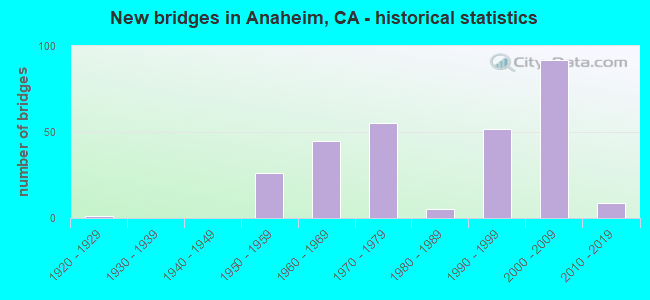
- New bridges - historical statistics
- 11920-1929
- 261950-1959
- 451960-1969
- 551970-1979
- 51980-1989
- 521990-1999
- 922000-2009
- 92010-2019
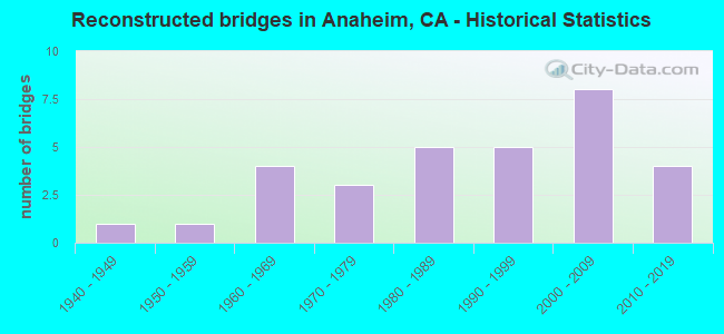
- Reconstructed bridges - Historical Statistics
- 11940-1949
- 11950-1959
- 41960-1969
- 31970-1979
- 51980-1989
- 51990-1999
- 82000-2009
- 42010-2019
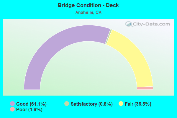
- Bridge Condition - Deck
- 61.1%Good
- 0.8%Satisfactory
- 36.5%Fair
- 1.6%Poor
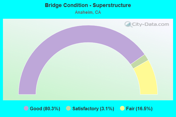
- Bridge Condition - Superstructure
- 80.3%Good
- 3.1%Satisfactory
- 16.5%Fair
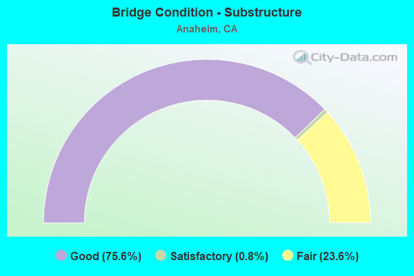
- Bridge Condition - Substructure
- 75.6%Good
- 0.8%Satisfactory
- 23.6%Fair
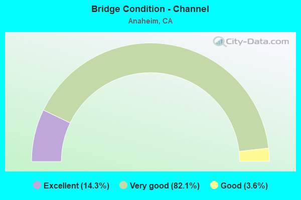
- Bridge Condition - Channel
- 14.3%Excellent
- 82.1%Very good
- 3.6%Good
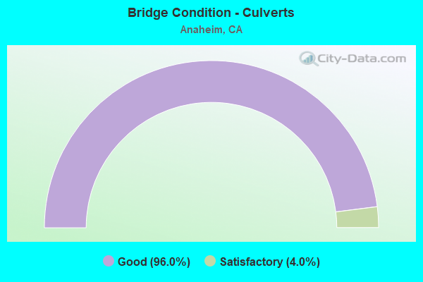
- Bridge Condition - Culverts
- 96.0%Good
- 4.0%Satisfactory
Find on map >> Show street view
Structure Number: 55C0319, Location: 0.1 MI. E/O KRAEMER BLVD. (Lat: 33.851256, Lng: -117.856161), Route carried "on" structure: City street , Year Built: 1960, Year Reconstructed: 2010, Status: Open, Structure Length: 1.77m (5.81ft), Average Daily Traffic: 27,000 (year 2017), Truck Traffic: 1%, Average Future Daily Traffic: 56,764 (year 2039), Design Load: HS 20, Features Intersected: CARBON CYN DIVERSION CHA, Facility Carried by Structure: LA PALMA AVENUE
Minimum Vertical Clearance: 30+ m (98+ ft), Kilometerpoint: 0.000, Lanes on structure: 6, Base Highway Network: Yes, Owner: City or Municipal Highway Agency, Approaching Roadway Width: 28.8m (94.5ft), Skew: 31 degrees, Material/Design: Prestressed concrete, Design/Construction: Box Beam or Girders - Multiple, Number Of Spans In Main Unit: 1, Length of Maximum Span: 17.4m (57.1ft), Curb or Sidewalk Widths: Left: 6.0m (19.7ft), Right: 2.1m (6.9ft), Curb-To-Curb Width: 28.8m (94.5ft), Out-to-Out Width: 38.7m (127.0ft)
Condition: Deck: Good, Superstructure: Fair, Substructure: Good, Channel: Very good, Operating Rating: 66.1 metric tons, Method Used To Determine Operating Rating: Load Factor (LF), Inventory Rating: 32.4 metric tons, Method Used To Determine Inventory Rating: Load Factor (LF), Structural Evaluation: Somewhat better than minimum adequacy, Deck Geometry: Superior to present desirable criteria, Waterway Adequacy: Superior to present desirable criteria, Approach Roadway Alignment: Equal to present desirable criteria, Designated Inspection Frequency: Every 24 months, Inspection Date: August 2021, Deck Structure Type: Concrete Cast-file-Place, Wearing Surface/Protective System: Wearing Surface: Bituminous
Find on map >> Show street view
Structure Number: 55C0342L, Location: 0.2 MI E JAMBOREE RD (Lat: 33.691642, Lng: -117.823208), Route carried "on" structure: City street , Year Built: 1969, Year Reconstructed: 1978, Status: Open, Structure Length: 4.11m (13.48ft), Average Daily Traffic: 10,700 (year 2018), Truck Traffic: 7%, Average Future Daily Traffic: 13,400 (year 2040), Design Load: HS 20, Features Intersected: PETERS CANYON CHANNEL, Facility Carried by Structure: BARANCA PKWY WB
Minimum Vertical Clearance: 30+ m (98+ ft), Kilometerpoint: 0.000, Lanes on structure: 3, Owner: City or Municipal Highway Agency, Approaching Roadway Width: 13.1m (43.0ft), Skew: 1 degrees, Material/Design: Concrete continuous, Design/Construction: Tee Beam, Number Of Spans In Main Unit: 3, Length of Maximum Span: 16.2m (53.1ft), Curb or Sidewalk Widths: Left: 0.0m, Right: 1.5m (4.9ft), Curb-To-Curb Width: 13.1m (43.0ft), Out-to-Out Width: 15.8m (51.8ft)
Condition: Deck: Fair, Superstructure: Good, Substructure: Good, Channel: Very good, Operating Rating: 61.2 metric tons, Method Used To Determine Operating Rating: Load Factor (LF), Inventory Rating: 36.9 metric tons, Method Used To Determine Inventory Rating: Load Factor (LF), Structural Evaluation: Better than present minimum criteria, Deck Geometry: Meets minimum limits, Waterway Adequacy: Superior to present desirable criteria, Approach Roadway Alignment: Equal to present desirable criteria, Designated Inspection Frequency: Every 24 months, Inspection Date: November 2021, Deck Structure Type: Concrete Cast-file-Place
Find on map >> Show street view
Structure Number: 55C0347, Location: 0.1 MI. S/O LINCOLN AVE. (Lat: 33.830908, Lng: -117.978894), Route carried "on" structure: City street , Year Built: 1959, Status: Open, Structure Length: 1.34m (4.40ft), Average Daily Traffic: 120 (year 2010), Truck Traffic: 1%, Average Future Daily Traffic: 108 (year 2037), Design Load: HS 20, Features Intersected: CARBON CREEK CHANNEL, Facility Carried by Structure: STINSON STREET
Minimum Vertical Clearance: 30+ m (98+ ft), Kilometerpoint: 0.000, Lanes on structure: 2, Owner: City or Municipal Highway Agency, Approaching Roadway Width: 10.9m (35.8ft), Skew: 4 degrees, Material/Design: Prestressed concrete, Design/Construction: Slab, Number Of Spans In Main Unit: 1, Length of Maximum Span: 12.8m (42.0ft), Curb or Sidewalk Widths: Left: 1.3m (4.3ft), Right: 1.3m (4.3ft), Curb-To-Curb Width: 7.3m (24.0ft), Out-to-Out Width: 10.4m (34.1ft)
Condition: Deck: Good, Superstructure: Good, Substructure: Good, Channel: Very good, Operating Rating: 69.0 metric tons, Method Used To Determine Operating Rating: Load Factor (LF), Inventory Rating: 35.6 metric tons, Method Used To Determine Inventory Rating: Load Factor (LF), Structural Evaluation: Better than present minimum criteria, Deck Geometry: Somewhat better than minimum adequacy, Waterway Adequacy: Superior to present desirable criteria, Approach Roadway Alignment: Equal to present desirable criteria, Designated Inspection Frequency: Every 48 months, Inspection Date: July 2019, Deck Structure Type: Concrete Precast Panels, Wearing Surface/Protective System: Wearing Surface: Bituminous
Find on map >> Show street view
Structure Number: 55C0348, Location: AT CRESCENT AVENUE (Lat: 33.839906, Lng: -117.958692), Route carried "on" structure: City street , Year Built: 1959, Year Reconstructed: 1971, Status: Open, Structure Length: 0.76m (2.49ft), Average Daily Traffic: 35,000 (year 2011), Truck Traffic: 1%, Average Future Daily Traffic: 60,371 (year 2043), Design Load: HS 20, Features Intersected: CARBON CREEK CHANNEL, Facility Carried by Structure: BROOKHURST STREET
Minimum Vertical Clearance: 30+ m (98+ ft), Kilometerpoint: 0.000, Lanes on structure: 7, Base Highway Network: Yes, Owner: City or Municipal Highway Agency, Approaching Roadway Width: 28.0m (91.9ft), Skew: 9 degrees, Material/Design: Concrete, Design/Construction: Culvert, Number Of Spans In Main Unit: 1, Length of Maximum Span: 7.3m (24.0ft), Curb or Sidewalk Widths: Left: 2.4m (7.9ft), Right: 1.5m (4.9ft), Curb-To-Curb Width: 28.0m (91.9ft), Out-to-Out Width: 37.0m (121.4ft)
Condition: Channel: Very good, Culverts: Good, Operating Rating: 40.5 metric tons, Method Used To Determine Operating Rating: Field evaluation and documented engineering judgment, Inventory Rating: 24.3 metric tons, Method Used To Determine Inventory Rating: Field evaluation and documented engineering judgment, Structural Evaluation: Equal to present minimum criteria, Deck Geometry: Somewhat better than minimum adequacy, Waterway Adequacy: Equal to present desirable criteria, Approach Roadway Alignment: Equal to present desirable criteria, Designated Inspection Frequency: Every 24 months, Inspection Date: September 2021
Find on map >> Show street view
Structure Number: 55C0349, Location: 0.1 MI. N/O CRESCENT AVE. (Lat: 33.840578, Lng: -117.956261), Route carried "on" structure: City street , Year Built: 1960, Status: Open, Structure Length: 0.98m (3.22ft), Average Daily Traffic: 1,200 (year 2010), Truck Traffic: 1%, Average Future Daily Traffic: 1,129 (year 2043), Design Load: HS 20, Features Intersected: CARBON CREEK CHANNEL, Facility Carried by Structure: VALLEY STREET
Minimum Vertical Clearance: 30+ m (98+ ft), Kilometerpoint: 0.000, Lanes on structure: 2, Owner: City or Municipal Highway Agency, Approaching Roadway Width: 15.7m (51.5ft), Skew: 1 degrees, Material/Design: Prestressed concrete, Design/Construction: Slab, Number Of Spans In Main Unit: 1, Length of Maximum Span: 9.4m (30.8ft), Curb or Sidewalk Widths: Left: 0.5m (1.6ft), Right: 1.9m (6.2ft), Curb-To-Curb Width: 15.7m (51.5ft), Out-to-Out Width: 18.3m (60.0ft)
Condition: Deck: Good, Superstructure: Good, Substructure: Good, Channel: Very good, Operating Rating: 66.7 metric tons, Method Used To Determine Operating Rating: Load Factor (LF), Inventory Rating: 32.4 metric tons, Method Used To Determine Inventory Rating: Load Factor (LF), Structural Evaluation: Better than present minimum criteria, Deck Geometry: Superior to present desirable criteria, Waterway Adequacy: Equal to present desirable criteria, Approach Roadway Alignment: Equal to present desirable criteria, Designated Inspection Frequency: Every 48 months, Inspection Date: September 2021, Deck Structure Type: Concrete Precast Panels, Wearing Surface/Protective System: Wearing Surface: Bituminous
Find on map >> Show street view
Structure Number: 55C0351, Location: 0.2 MI. N/O CRESCENT AVE. (Lat: 33.842186, Lng: -117.937225), Route carried "on" structure: City street , Year Built: 1961, Status: Open, Structure Length: 1.22m (4.00ft), Average Daily Traffic: 5,900 (year 2009), Truck Traffic: 1%, Average Future Daily Traffic: 11,087 (year 2043), Design Load: HS 20, Features Intersected: CARBON CREEK CHANNEL, Facility Carried by Structure: LOARA STREET
Minimum Vertical Clearance: 30+ m (98+ ft), Kilometerpoint: 0.000, Lanes on structure: 2, Owner: City or Municipal Highway Agency, Approaching Roadway Width: 12.8m (42.0ft), Skew: 3 degrees, Material/Design: Prestressed concrete, Design/Construction: Slab, Number Of Spans In Main Unit: 1, Length of Maximum Span: 11.9m (39.0ft), Curb or Sidewalk Widths: Left: 1.3m (4.3ft), Right: 1.3m (4.3ft), Curb-To-Curb Width: 8.5m (27.9ft), Out-to-Out Width: 11.6m (38.1ft)
Condition: Deck: Good, Superstructure: Good, Substructure: Good, Channel: Very good, Operating Rating: 66.7 metric tons, Method Used To Determine Operating Rating: Load Factor (LF), Inventory Rating: 32.4 metric tons, Method Used To Determine Inventory Rating: Load Factor (LF), Structural Evaluation: Better than present minimum criteria, Deck Geometry: High priority of replacement, Waterway Adequacy: Superior to present desirable criteria, Approach Roadway Alignment: Equal to present desirable criteria, Designated Inspection Frequency: Every 48 months, Inspection Date: September 2021, Deck Structure Type: Concrete Precast Panels, Wearing Surface/Protective System: Wearing Surface: Bituminous
Find on map >> Show street view
Structure Number: 55C0352, Location: 0.1 MI. S/O LA PALMA AVE. (Lat: 33.846297, Lng: -117.931564), Route carried "on" structure: City street , Year Built: 1961, Status: Open, Structure Length: 1.10m (3.61ft), Average Daily Traffic: 6,700 (year 2009), Truck Traffic: 1%, Average Future Daily Traffic: 19,955 (year 2043), Design Load: HS 20, Features Intersected: CARBON CREEK CHANNEL, Facility Carried by Structure: WEST STREET
Minimum Vertical Clearance: 30+ m (98+ ft), Kilometerpoint: 0.000, Lanes on structure: 2, Owner: City or Municipal Highway Agency, Approaching Roadway Width: 12.2m (40.0ft), Skew: 1 degrees, Material/Design: Prestressed concrete, Design/Construction: Slab, Number Of Spans In Main Unit: 1, Length of Maximum Span: 10.7m (35.1ft), Curb or Sidewalk Widths: Left: 1.3m (4.3ft), Right: 1.3m (4.3ft), Curb-To-Curb Width: 8.5m (27.9ft), Out-to-Out Width: 11.6m (38.1ft)
Condition: Deck: Good, Superstructure: Good, Substructure: Good, Channel: Very good, Operating Rating: 58.3 metric tons, Method Used To Determine Operating Rating: Load Factor (LF), Inventory Rating: 32.4 metric tons, Method Used To Determine Inventory Rating: Load Factor (LF), Structural Evaluation: Better than present minimum criteria, Deck Geometry: High priority of replacement, Waterway Adequacy: Equal to present desirable criteria, Approach Roadway Alignment: Equal to present desirable criteria, Designated Inspection Frequency: Every 48 months, Inspection Date: September 2021, Deck Structure Type: Concrete Precast Panels, Wearing Surface/Protective System: Wearing Surface: Bituminous
Find on map >> Show street view
Structure Number: 55C0353, Location: 300' W/O EAST STREET (Lat: 33.850197, Lng: -117.907844), Route carried "on" structure: City street , Year Built: 1961, Status: Open, Structure Length: 1.65m (5.41ft), Average Daily Traffic: 600 (year 2017), Truck Traffic: 1%, Average Future Daily Traffic: 536 (year 2039), Design Load: HS 20, Features Intersected: CARBON CREEK CHANNEL, Facility Carried by Structure: BALSAM AVENUE
Minimum Vertical Clearance: 30+ m (98+ ft), Kilometerpoint: 0.000, Lanes on structure: 2, Owner: City or Municipal Highway Agency, Approaching Roadway Width: 12.2m (40.0ft), Material/Design: Prestressed concrete, Design/Construction: Slab, Number Of Spans In Main Unit: 2, Length of Maximum Span: 8.2m (26.9ft), Curb or Sidewalk Widths: Left: 1.5m (4.9ft), Right: 1.5m (4.9ft), Curb-To-Curb Width: 8.5m (27.9ft), Out-to-Out Width: 12.2m (40.0ft)
Condition: Deck: Good, Superstructure: Good, Substructure: Good, Channel: Very good, Operating Rating: 82.9 metric tons, Method Used To Determine Operating Rating: Load Factor (LF), Inventory Rating: 32.4 metric tons, Method Used To Determine Inventory Rating: Load Factor (LF), Structural Evaluation: Better than present minimum criteria, Deck Geometry: Somewhat better than minimum adequacy, Waterway Adequacy: Superior to present desirable criteria, Approach Roadway Alignment: Somewhat better than minimum adequacy, Designated Inspection Frequency: Every 48 months, Inspection Date: August 2021, Deck Structure Type: Concrete Precast Panels, Wearing Surface/Protective System: Wearing Surface: Bituminous
Find on map >> Show street view
Structure Number: 55C0354, Location: 300' W/O EAST STREET (Lat: 33.851772, Lng: -117.907797), Route carried "on" structure: City street , Year Built: 1961, Status: Open, Structure Length: 1.68m (5.51ft), Average Daily Traffic: 600 (year 2017), Truck Traffic: 1%, Average Future Daily Traffic: 536 (year 2039), Design Load: HS 20, Features Intersected: CARBON CREEK CHANNEL, Facility Carried by Structure: KENWOOD AVENUE
Minimum Vertical Clearance: 30+ m (98+ ft), Kilometerpoint: 0.000, Lanes on structure: 2, Owner: City or Municipal Highway Agency, Approaching Roadway Width: 12.2m (40.0ft), Skew: 1 degrees, Material/Design: Prestressed concrete, Design/Construction: Slab, Number Of Spans In Main Unit: 2, Length of Maximum Span: 8.2m (26.9ft), Curb or Sidewalk Widths: Left: 1.2m (3.9ft), Right: 1.2m (3.9ft), Curb-To-Curb Width: 9.1m (29.9ft), Out-to-Out Width: 12.2m (40.0ft)
Condition: Deck: Good, Superstructure: Good, Substructure: Good, Channel: Very good, Operating Rating: 81.6 metric tons, Method Used To Determine Operating Rating: Load Factor (LF), Inventory Rating: 32.4 metric tons, Method Used To Determine Inventory Rating: Load Factor (LF), Structural Evaluation: Better than present minimum criteria, Deck Geometry: Equal to present minimum criteria, Waterway Adequacy: Superior to present desirable criteria, Approach Roadway Alignment: Equal to present desirable criteria, Designated Inspection Frequency: Every 48 months, Inspection Date: August 2021, Deck Structure Type: Concrete Precast Panels, Wearing Surface/Protective System: Wearing Surface: Bituminous
Find on map >> Show street view
Structure Number: 55C046, Location: 0.2 MI. NE/O EDINGER AVE. (Lat: 33.706122, Lng: -117.803614), Route carried "on" structure: City street , Year Built: 1985, Year Reconstructed: 1998, Status: Open, Structure Length: 4.63m (15.19ft), Average Daily Traffic: 73,000 (year 2013), Truck Traffic: 1%, Average Future Daily Traffic: 137,378 (year 2038), Design Load: HS 20+Mod, Features Intersected: BNSF RY,AMTRAK,METROLINK, Facility Carried by Structure: JAMBOREE ROAD
Minimum Vertical Clearance: 30+ m (98+ ft), Kilometerpoint: 0.000, Lanes on structure: 13, Base Highway Network: Yes, Owner: City or Municipal Highway Agency, Approaching Roadway Width: 64.4m (211.3ft), Skew: 31 degrees, Material/Design: Concrete continuous, Design/Construction: Tee Beam, Number Of Spans In Main Unit: 3, Length of Maximum Span: 20.4m (66.9ft), Curb or Sidewalk Widths: Left: 0.9m (3.0ft), Right: 1.8m (5.9ft), Curb-To-Curb Width: 64.4m (211.3ft), Out-to-Out Width: 71.0m (232.9ft)
Condition: Deck: Good, Superstructure: Good, Substructure: Good, Operating Rating: 54.1 metric tons, Method Used To Determine Operating Rating: Assigned rating based on Load Factor Design (LFD) reported in metric tons, Inventory Rating: 32.4 metric tons, Method Used To Determine Inventory Rating: Assigned rating based on Load Factor Design (LFD) reported in metric tons, Structural Evaluation: Better than present minimum criteria, Deck Geometry: Superior to present desirable criteria, Underclear: Equal to present minimum criteria, Approach Roadway Alignment: Equal to present desirable criteria, Designated Inspection Frequency: Every 48 months, Inspection Date: June 2021, Deck Structure Type: Concrete Cast-file-Place
Find on map >> Show street view
Structure Number: 55C0469, Location: 0.1 MI. S/O LA PALMA AVE. (Lat: 33.849656, Lng: -117.856253), Route carried "on" structure: City street , Year Built: 1960, Year Reconstructed: 2010, Status: Open, Structure Length: 2.38m (7.81ft), Average Daily Traffic: 47,400 (year 2012), Truck Traffic: 6%, Average Future Daily Traffic: 90,403 (year 2039), Design Load: H 15, Features Intersected: CARBON CYN DIVERSION CHA, Facility Carried by Structure: KRAEMER BOULEVARD
Minimum Vertical Clearance: 30+ m (98+ ft), Kilometerpoint: 0.000, Lanes on structure: 7, Base Highway Network: Yes, Owner: City or Municipal Highway Agency, Approaching Roadway Width: 24.2m (79.4ft), Skew: 24 degrees, Material/Design: Concrete, Design/Construction: Culvert, Number Of Spans In Main Unit: 3, Length of Maximum Span: 4.3m (14.1ft), Curb or Sidewalk Widths: Left: 1.8m (5.9ft), Right: 0.2m (0.7ft), Curb-To-Curb Width: 30.5m (100.1ft), Out-to-Out Width: 35.7m (117.1ft)
Condition: Channel: Very good, Culverts: Good, Operating Rating: 40.5 metric tons, Method Used To Determine Operating Rating: Field evaluation and documented engineering judgment, Inventory Rating: 24.3 metric tons, Method Used To Determine Inventory Rating: Field evaluation and documented engineering judgment, Structural Evaluation: Equal to present minimum criteria, Deck Geometry: Better than present minimum criteria, Waterway Adequacy: Superior to present desirable criteria, Approach Roadway Alignment: Equal to present desirable criteria, Designated Inspection Frequency: Every 24 months, Inspection Date: August 2021
Find on map >> Show street view
Structure Number: 55C0472, Location: 0.2 MI N OF MAIN ST (Lat: 33.682203, Lng: -117.838031), Route carried "on" structure: City street , Year Built: 1975, Year Reconstructed: 2006, Status: Open, Structure Length: 0.76m (2.49ft), Average Daily Traffic: 61,300 (year 2018), Truck Traffic: 7%, Average Future Daily Traffic: 74,502 (year 2038), Features Intersected: BARRANCA CHANNEL, Facility Carried by Structure: JAMBOREE ROAD
Minimum Vertical Clearance: 30+ m (98+ ft), Kilometerpoint: 0.000, Lanes on structure: 9, Base Highway Network: Yes, Owner: City or Municipal Highway Agency, Approaching Roadway Width: 32.9m (107.9ft), Skew: 30 degrees, Material/Design: Concrete, Design/Construction: Culvert, Number Of Spans In Main Unit: 2, Length of Maximum Span: 3.7m (12.1ft), Curb or Sidewalk Widths: Left: 1.7m (5.6ft), Right: 2.0m (6.6ft), Curb-To-Curb Width: 32.9m (107.9ft), Out-to-Out Width: 41.3m (135.5ft)
Condition: Channel: Very good, Culverts: Good, Operating Rating: 54.1 metric tons, Method Used To Determine Operating Rating: Field evaluation and documented engineering judgment, Inventory Rating: 32.4 metric tons, Method Used To Determine Inventory Rating: Field evaluation and documented engineering judgment, Structural Evaluation: Better than present minimum criteria, Deck Geometry: Meets minimum limits, Waterway Adequacy: Superior to present desirable criteria, Approach Roadway Alignment: Equal to present desirable criteria, Designated Inspection Frequency: Every 48 months, Inspection Date: November 2020
Find on map >> Show street view
Structure Number: 55C0509, Location: 0.2 MI NORTH OF FWY 91 (Lat: 33.874053, Lng: -117.747519), Route carried "on" structure: City street , Year Built: 1983, Status: Open, Structure Length: 23.62m (77.49ft), Average Daily Traffic: 34,000 (year 2012), Truck Traffic: 1%, Average Future Daily Traffic: 71,480 (year 2039), Design Load: HS 20+Mod, Features Intersected: SANTA ANA RIVER CHANNEL, Facility Carried by Structure: WEIR CANYON ROAD
Minimum Vertical Clearance: 30+ m (98+ ft), Kilometerpoint: 0.000, Lanes on structure: 6, Lanes under structure: 5, Base Highway Network: Yes, Owner: City or Municipal Highway Agency, Approaching Roadway Width: 25.9m (85.0ft), Skew: 9 degrees, Material/Design: Concrete continuous, Design/Construction: Box Beam or Girders - Multiple, Number Of Spans In Main Unit: 6, Number Of Approach Spans: 1, Length of Maximum Span: 40.1m (131.6ft), Curb or Sidewalk Widths: Left: 1.5m (4.9ft), Right: 1.5m (4.9ft), Curb-To-Curb Width: 23.0m (75.5ft), Out-to-Out Width: 26.8m (87.9ft)
Condition: Deck: Fair, Superstructure: Good, Substructure: Good, Channel: Very good, Operating Rating: 54.1 metric tons, Method Used To Determine Operating Rating: Assigned rating based on Load Factor Design (LFD) reported in metric tons, Inventory Rating: 32.4 metric tons, Method Used To Determine Inventory Rating: Assigned rating based on Load Factor Design (LFD) reported in metric tons, Structural Evaluation: Better than present minimum criteria, Deck Geometry: Meets minimum limits, Underclear: Meets minimum limits, Waterway Adequacy: Superior to present desirable criteria, Approach Roadway Alignment: Equal to present desirable criteria, Designated Inspection Frequency: Every 24 months, Inspection Date: August 2021, Deck Structure Type: Concrete Cast-file-Place
Find on map >> Show street view
Structure Number: 55C051, Location: 0.43 MI. N/O ROUTE 91 FWY (Lat: 33.854789, Lng: -117.816700), Route carried "on" structure: City street , Year Built: 1970, Year Reconstructed: 1979, Status: Open, Structure Length: 12.16m (39.90ft), Average Daily Traffic: 37,300 (year 2012), Truck Traffic: 6%, Average Future Daily Traffic: 44,297 (year 2039), Design Load: HS 20, Features Intersected: SANTA ANA RIVER CHANNEL, Facility Carried by Structure: LAKEVIEW AVENUE
Minimum Vertical Clearance: 30+ m (98+ ft), Kilometerpoint: 0.000, Lanes on structure: 4, Base Highway Network: Yes, Owner: City or Municipal Highway Agency, Approaching Roadway Width: 20.4m (66.9ft), Material/Design: Concrete continuous, Design/Construction: Tee Beam, Number Of Spans In Main Unit: 6, Length of Maximum Span: 21.9m (71.9ft), Curb or Sidewalk Widths: Left: 1.5m (4.9ft), Right: 1.5m (4.9ft), Curb-To-Curb Width: 20.4m (66.9ft), Out-to-Out Width: 24.4m (80.1ft)
Condition: Deck: Poor, Superstructure: Good, Substructure: Good, Channel: Very good, Operating Rating: 83.3 metric tons, Method Used To Determine Operating Rating: Load Factor (LF), Inventory Rating: 50.2 metric tons, Method Used To Determine Inventory Rating: Load Factor (LF), Structural Evaluation: Better than present minimum criteria, Deck Geometry: Superior to present desirable criteria, Waterway Adequacy: Superior to present desirable criteria, Approach Roadway Alignment: Equal to present desirable criteria, Designated Inspection Frequency: Every 24 months, Inspection Date: August 2021, Deck Structure Type: Concrete Cast-file-Place
Find on map >> Show street view
Structure Number: 55C0515, Location: 0.2 MI. W/O MAGNOLIA ST. (Lat: 33.832069, Lng: -117.978319), Route carried "on" structure: City street , Year Built: 1959, Status: Open, Structure Length: 0.85m (2.79ft), Average Daily Traffic: 25,000 (year 2001), Truck Traffic: 1%, Average Future Daily Traffic: 55,249 (year 2043), Features Intersected: CARBON CREEK CHANNEL, Facility Carried by Structure: LINCOLN AVENUE
Minimum Vertical Clearance: 30+ m (98+ ft), Kilometerpoint: 0.000, Lanes on structure: 4, Base Highway Network: Yes, Owner: City or Municipal Highway Agency, Approaching Roadway Width: 19.6m (64.3ft), Skew: 31 degrees, Material/Design: Concrete, Design/Construction: Culvert, Number Of Spans In Main Unit: 2, Length of Maximum Span: 3.8m (12.5ft), Curb or Sidewalk Widths: Left: 1.7m (5.6ft), Right: 1.7m (5.6ft), Curb-To-Curb Width: 19.6m (64.3ft), Out-to-Out Width: 29.0m (95.1ft)
Condition: Channel: Very good, Culverts: Good, Operating Rating: 54.1 metric tons, Method Used To Determine Operating Rating: Field evaluation and documented engineering judgment, Inventory Rating: 32.4 metric tons, Method Used To Determine Inventory Rating: Field evaluation and documented engineering judgment, Structural Evaluation: Better than present minimum criteria, Deck Geometry: Better than present minimum criteria, Waterway Adequacy: Equal to present desirable criteria, Approach Roadway Alignment: Equal to present desirable criteria, Designated Inspection Frequency: Every 48 months, Inspection Date: September 2021
Find on map >> Show street view
Structure Number: 55C0522, Location: 0.2 MI N/O FWY 91 (Lat: 33.872903, Lng: -117.746031), Route carried "on" structure: City street , Year Built: 1984, Status: Open, Structure Length: 2.41m (7.91ft), Average Daily Traffic: 34,000 (year 2012), Truck Traffic: 1%, Average Future Daily Traffic: 71,480 (year 2039), Features Intersected: OLD CANAL ROAD, Facility Carried by Structure: WEIR CANYON ROAD
Minimum Vertical Clearance: 30+ m (98+ ft), Kilometerpoint: 0.000, Lanes on structure: 8, Lanes under structure: 3, Base Highway Network: Yes, Owner: City or Municipal Highway Agency, Approaching Roadway Width: 30.8m (101.0ft), Material/Design: Steel, Design/Construction: Arch - Deck, Number Of Spans In Main Unit: 2, Length of Maximum Span: 11.6m (38.1ft), Curb or Sidewalk Widths: Left: 3.3m (10.8ft), Right: 3.6m (11.8ft), Curb-To-Curb Width: 30.8m (101.0ft), Out-to-Out Width: 38.0m (124.7ft)
Condition: Superstructure: Fair, Substructure: Fair, Operating Rating: 54.1 metric tons, Method Used To Determine Operating Rating: Field evaluation and documented engineering judgment, Inventory Rating: 32.4 metric tons, Method Used To Determine Inventory Rating: Field evaluation and documented engineering judgment, Structural Evaluation: Somewhat better than minimum adequacy, Deck Geometry: Somewhat better than minimum adequacy, Underclear: Meets minimum limits, Approach Roadway Alignment: Equal to present desirable criteria, Designated Inspection Frequency: Every 24 months, Inspection Date: August 2021
Find on map >> Show street view
Structure Number: 55C0532, Location: 100' N/O NOHL RANCH ROAD (Lat: 33.844544, Lng: -117.777131), Route carried "on" structure: City street , Year Built: 1972, Status: Open, Structure Length: 0.64m (2.10ft), Average Daily Traffic: 12,000 (year 2009), Truck Traffic: 1%, Average Future Daily Traffic: 25,397 (year 2038), Features Intersected: WALNUT CANYON CHANNEL, Facility Carried by Structure: ANAHEIM HILLS ROAD
Minimum Vertical Clearance: 30+ m (98+ ft), Kilometerpoint: 0.000, Lanes on structure: 5, Base Highway Network: Yes, Owner: City or Municipal Highway Agency, Approaching Roadway Width: 21.4m (70.2ft), Skew: 21 degrees, Material/Design: Concrete, Design/Construction: Culvert, Number Of Spans In Main Unit: 2, Length of Maximum Span: 3.0m (9.8ft), Curb or Sidewalk Widths: Left: 0.2m (0.7ft), Right: 1.5m (4.9ft), Curb-To-Curb Width: 21.4m (70.2ft), Out-to-Out Width: 32.0m (105.0ft)
Condition: Channel: Excellent, Culverts: Good, Operating Rating: 40.5 metric tons, Method Used To Determine Operating Rating: Field evaluation and documented engineering judgment, Inventory Rating: 24.3 metric tons, Method Used To Determine Inventory Rating: Field evaluation and documented engineering judgment, Structural Evaluation: Equal to present minimum criteria, Deck Geometry: Somewhat better than minimum adequacy, Waterway Adequacy: Superior to present desirable criteria, Approach Roadway Alignment: Equal to present desirable criteria, Designated Inspection Frequency: Every 24 months, Inspection Date: September 2021
Find on map >> Show street view
Structure Number: 55C0533, Location: 100' N/O NOHL RANCH ROAD (Lat: 33.843353, Lng: -117.775722), Route carried "on" structure: City street , Year Built: 1972, Status: Open, Structure Length: 0.70m (2.30ft), Average Daily Traffic: 4,400 (year 2009), Truck Traffic: 1%, Average Future Daily Traffic: 6,987 (year 2038), Features Intersected: WALNUT CANYON CHANNEL, Facility Carried by Structure: CANYON RIM ROAD
Minimum Vertical Clearance: 30+ m (98+ ft), Kilometerpoint: 0.000, Lanes on structure: 4, Owner: City or Municipal Highway Agency, Approaching Roadway Width: 19.5m (64.0ft), Material/Design: Concrete, Design/Construction: Culvert, Number Of Spans In Main Unit: 2, Length of Maximum Span: 3.0m (9.8ft), Curb or Sidewalk Widths: Left: 1.5m (4.9ft), Right: 1.4m (4.6ft), Curb-To-Curb Width: 19.5m (64.0ft), Out-to-Out Width: 25.3m (83.0ft)
Condition: Channel: Excellent, Culverts: Good, Operating Rating: 40.5 metric tons, Method Used To Determine Operating Rating: Field evaluation and documented engineering judgment, Inventory Rating: 24.3 metric tons, Method Used To Determine Inventory Rating: Field evaluation and documented engineering judgment, Structural Evaluation: Equal to present minimum criteria, Deck Geometry: Better than present minimum criteria, Waterway Adequacy: Superior to present desirable criteria, Approach Roadway Alignment: Equal to present desirable criteria, Designated Inspection Frequency: Every 24 months, Inspection Date: September 2021
Find on map >> Show street view
Structure Number: 55C055, Location: 100' W/O ALICIA PARKWAY (Lat: 33.555483, Lng: -117.718767), Route carried "on" structure: County highway , Year Built: 1988, Year Reconstructed: 1993, Status: Open, Structure Length: 5.19m (17.03ft), Average Daily Traffic: 25,915 (year 2011), Truck Traffic: 1%, Average Future Daily Traffic: 48,795 (year 2038), Design Load: HS 20+Mod, Features Intersected: ALISO CREEK, Facility Carried by Structure: ALISO CREEK ROAD
Minimum Vertical Clearance: 30+ m (98+ ft), Kilometerpoint: 0.000, Lanes on structure: 9, Base Highway Network: Yes, Owner: County Highway Agency, Approaching Roadway Width: 34.5m (113.2ft), Skew: 2 degrees, Material/Design: Prestressed concrete, Design/Construction: Box Beam or Girders - Multiple, Number Of Spans In Main Unit: 1, Length of Maximum Span: 50.0m (164.0ft), Curb or Sidewalk Widths: Left: 1.5m (4.9ft), Right: 1.5m (4.9ft), Curb-To-Curb Width: 34.5m (113.2ft), Out-to-Out Width: 38.0m (124.7ft)
Condition: Deck: Good, Superstructure: Good, Substructure: Good, Channel: Very good, Operating Rating: 54.1 metric tons, Method Used To Determine Operating Rating: Assigned rating based on Load Factor Design (LFD) reported in metric tons, Inventory Rating: 32.4 metric tons, Method Used To Determine Inventory Rating: Assigned rating based on Load Factor Design (LFD) reported in metric tons, Structural Evaluation: Better than present minimum criteria, Deck Geometry: Somewhat better than minimum adequacy, Waterway Adequacy: Equal to present desirable criteria, Approach Roadway Alignment: Equal to present desirable criteria, Designated Inspection Frequency: Every 24 months, Inspection Date: July 2021, Deck Structure Type: Concrete Cast-file-Place
Find on map >> Show street view
Structure Number: 55C0587, Location: 0.2 MI. W/O ORANGETHORPE (Lat: 33.867936, Lng: -117.853761), Route carried "on" structure: City street , Year Built: 1990, Status: Open, Structure Length: 1.34m (4.40ft), Average Daily Traffic: 3,300 (year 2009), Truck Traffic: 4%, Average Future Daily Traffic: 7,202 (year 2043), Design Load: HS 20+Mod, Features Intersected: CARBON CANYON CHANNEL, Facility Carried by Structure: CROWTHER AVENUE
Minimum Vertical Clearance: 30+ m (98+ ft), Kilometerpoint: 0.000, Lanes on structure: 4, Owner: City or Municipal Highway Agency, Approaching Roadway Width: 16.8m (55.1ft), Material/Design: Prestressed concrete, Design/Construction: Slab, Number Of Spans In Main Unit: 1, Length of Maximum Span: 13.1m (43.0ft), Curb or Sidewalk Widths: Left: 1.6m (5.2ft), Right: 0.0m, Curb-To-Curb Width: 16.8m (55.1ft), Out-to-Out Width: 19.2m (63.0ft)
Condition: Deck: Good, Superstructure: Good, Substructure: Fair, Channel: Excellent, Operating Rating: 54.1 metric tons, Method Used To Determine Operating Rating: Assigned rating based on Load Factor Design (LFD) reported in metric tons, Inventory Rating: 32.4 metric tons, Method Used To Determine Inventory Rating: Assigned rating based on Load Factor Design (LFD) reported in metric tons, Structural Evaluation: Somewhat better than minimum adequacy, Deck Geometry: Somewhat better than minimum adequacy, Waterway Adequacy: Superior to present desirable criteria, Approach Roadway Alignment: Equal to present desirable criteria, Designated Inspection Frequency: Every 24 months, Inspection Date: September 2021, Deck Structure Type: Concrete Precast Panels, Wearing Surface/Protective System: Wearing Surface: Bituminous
Find on map >> Show street view
Structure Number: 55C0613, Location: 300' S/O ROUTE I-5 FRWY. (Lat: 33.853622, Lng: -117.976006), Route carried "on" structure: City street , Year Built: 1999, Status: Open, Structure Length: 4.75m (15.58ft), Average Daily Traffic: 41,400 (year 2009), Truck Traffic: 6%, Average Future Daily Traffic: 86,189 (year 2043), Design Load: HS 20+Mod, Features Intersected: UP RR, Facility Carried by Structure: MAGNOLIA AVENUE
Minimum Vertical Clearance: 30+ m (98+ ft), Kilometerpoint: 0.000, Lanes on structure: 7, Base Highway Network: Yes, Owner: City or Municipal Highway Agency, Approaching Roadway Width: 24.7m (81.0ft), Skew: 23 degrees, Material/Design: Prestressed concrete, Design/Construction: Box Beam or Girders - Multiple, Number Of Spans In Main Unit: 1, Length of Maximum Span: 46.3m (151.9ft), Curb or Sidewalk Widths: Left: 1.8m (5.9ft), Right: 1.8m (5.9ft), Curb-To-Curb Width: 24.7m (81.0ft), Out-to-Out Width: 36.0m (118.1ft)
Condition: Deck: Fair, Superstructure: Good, Substructure: Good, Operating Rating: 54.1 metric tons, Method Used To Determine Operating Rating: Assigned rating based on Load Factor Design (LFD) reported in metric tons, Inventory Rating: 32.4 metric tons, Method Used To Determine Inventory Rating: Assigned rating based on Load Factor Design (LFD) reported in metric tons, Structural Evaluation: Better than present minimum criteria, Deck Geometry: High priority of replacement, Underclear: Equal to present desirable criteria, Approach Roadway Alignment: Equal to present desirable criteria, Designated Inspection Frequency: Every 24 months, Inspection Date: September 2021, Deck Structure Type: Concrete Cast-file-Place
Find on map >> Show street view
Structure Number: 55C0671, Location: 0.25 MI. S/O BALL ROAD (Lat: 33.814111, Lng: -117.924275), Route carried "on" structure: City street , Year Built: 2000, Status: Open, Structure Length: 20.33m (66.70ft), Average Daily Traffic: 18,200 (year 2018), Truck Traffic: 1%, Average Future Daily Traffic: 36,400 (year 2041), Design Load: HS 20+Mod, Features Intersected: DSNYLND PARKING TRAFFIC, Facility Carried by Structure: SB DISNEYLAND DR.
Minimum Vertical Clearance: 30+ m (98+ ft), Kilometerpoint: 0.000, Lanes on structure: 2, Lanes under structure: 15, Owner: City or Municipal Highway Agency, Approaching Roadway Width: 10.0m (32.8ft), Material/Design: Prestressed concrete continuous, Design/Construction: Box Beam or Girders - Multiple, Number Of Spans In Main Unit: 6, Length of Maximum Span: 39.9m (130.9ft), Curb-To-Curb Width: 10.0m (32.8ft), Out-to-Out Width: 11.0m (36.1ft)
Condition: Deck: Fair, Superstructure: Good, Substructure: Fair, Operating Rating: 54.1 metric tons, Method Used To Determine Operating Rating: Assigned rating based on Load Factor Design (LFD) reported in metric tons, Inventory Rating: 32.4 metric tons, Method Used To Determine Inventory Rating: Assigned rating based on Load Factor Design (LFD) reported in metric tons, Structural Evaluation: Somewhat better than minimum adequacy, Deck Geometry: Meets minimum limits, Underclear: Meets minimum limits, Approach Roadway Alignment: Equal to present desirable criteria, Designated Inspection Frequency: Every 24 months, Inspection Date: September 2021, Deck Structure Type: Concrete Cast-file-Place
Find on map >> Show street view
Structure Number: 55C0672, Location: AT BALL ROAD (Lat: 33.816244, Lng: -117.922278), Route carried "on" structure: City street , Year Built: 2000, Status: Open, Structure Length: 10.30m (33.79ft), Average Daily Traffic: 18,200 (year 2019), Truck Traffic: 1%, Average Future Daily Traffic: 21,024 (year 2041), Design Load: HS 20+Mod, Features Intersected: BALL ROAD, Facility Carried by Structure: DISNEYLAND FLYOVER
Minimum Vertical Clearance: 30+ m (98+ ft), Kilometerpoint: 0.000, Lanes on structure: 2, Owner: City or Municipal Highway Agency, Approaching Roadway Width: 9.1m (29.9ft), Material/Design: Concrete continuous, Design/Construction: Slab, Number Of Spans In Main Unit: 13, Length of Maximum Span: 7.9m (25.9ft), Curb-To-Curb Width: 9.1m (29.9ft), Out-to-Out Width: 10.1m (33.1ft)
Condition: Deck: Good, Superstructure: Good, Substructure: Good, Operating Rating: 33.4 metric tons, Method Used To Determine Operating Rating: Load and Resistance Factor Rating (LRFR) rating reported by rating factor(RF) method using HL-93 loadings, Inventory Rating: 25.6 metric tons, Method Used To Determine Inventory Rating: Load and Resistance Factor Rating (LRFR) rating reported by rating factor(RF) method using HL-93 loadings, Structural Evaluation: Equal to present minimum criteria, Deck Geometry: Meets minimum limits, Approach Roadway Alignment: Equal to present desirable criteria, Designated Inspection Frequency: Every 24 months, Inspection Date: September 2021, Deck Structure Type: Concrete Cast-file-Place
Find on map >> Show street view
Structure Number: 55C0673, Location: AT BALL ROAD (Lat: 33.817167, Lng: -117.922056), Route carried "on" structure: City street , Year Built: 2000, Status: Open, Structure Length: 14.08m (46.19ft), Average Daily Traffic: 18,200 (year 2019), Truck Traffic: 1%, Average Future Daily Traffic: 21,024 (year 2041), Design Load: HS 20+Mod, Features Intersected: BALL ROAD, Facility Carried by Structure: DISNEYLAND FLYOVER
Minimum Vertical Clearance: 30+ m (98+ ft), Kilometerpoint: 0.000, Lanes on structure: 2, Lanes under structure: 10, Owner: City or Municipal Highway Agency, Approaching Roadway Width: 9.1m (29.9ft), Material/Design: Prestressed concrete continuous, Design/Construction: Box Beam or Girders - Multiple, Number Of Spans In Main Unit: 2, Length of Maximum Span: 70.0m (229.7ft), Curb-To-Curb Width: 9.1m (29.9ft), Out-to-Out Width: 10.1m (33.1ft)
Condition: Deck: Fair, Superstructure: Good, Substructure: Good, Operating Rating: 54.1 metric tons, Method Used To Determine Operating Rating: Field evaluation and documented engineering judgment, Inventory Rating: 32.4 metric tons, Method Used To Determine Inventory Rating: Field evaluation and documented engineering judgment, Structural Evaluation: Better than present minimum criteria, Deck Geometry: Meets minimum limits, Underclear: Somewhat better than minimum adequacy, Approach Roadway Alignment: Equal to present desirable criteria, Designated Inspection Frequency: Every 24 months, Inspection Date: September 2021, Deck Structure Type: Concrete Cast-file-Place
Find on map >> Show street view
Structure Number: 55C0674, Location: AT BALL ROAD (Lat: 33.818306, Lng: -117.922158), Route carried "on" structure: City street , Year Built: 2000, Status: Open, Structure Length: 8.72m (28.61ft), Average Daily Traffic: 26,000 (year 2019), Truck Traffic: 1%, Average Future Daily Traffic: 31,200 (year 2041), Design Load: HS 20+Mod, Features Intersected: BALL ROAD, Facility Carried by Structure: DISNEYLAND FLYOVER
Minimum Vertical Clearance: 30+ m (98+ ft), Kilometerpoint: 0.000, Lanes on structure: 2, Owner: City or Municipal Highway Agency, Approaching Roadway Width: 9.0m (29.5ft), Material/Design: Concrete continuous, Design/Construction: Slab, Number Of Spans In Main Unit: 11, Length of Maximum Span: 7.9m (25.9ft), Curb-To-Curb Width: 9.0m (29.5ft), Out-to-Out Width: 10.1m (33.1ft)
Condition: Deck: Good, Superstructure: Good, Substructure: Good, Operating Rating: 31.1 metric tons, Method Used To Determine Operating Rating: Load and Resistance Factor Rating (LRFR) rating reported by rating factor(RF) method using HL-93 loadings, Inventory Rating: 24.0 metric tons, Method Used To Determine Inventory Rating: Load and Resistance Factor Rating (LRFR) rating reported by rating factor(RF) method using HL-93 loadings, Structural Evaluation: Somewhat better than minimum adequacy, Deck Geometry: High priority of corrective action, Approach Roadway Alignment: Equal to present desirable criteria, Designated Inspection Frequency: Every 24 months, Inspection Date: September 2021, Deck Structure Type: Concrete Cast-file-Place
Find on map >> Show street view
Structure Number: 55C0675, Location: 0.4 MI S/O BALL ROAD (Lat: 33.814069, Lng: -117.924111), Route carried "on" structure: City street , Year Built: 2000, Status: Open, Structure Length: 5.58m (18.31ft), Average Daily Traffic: 18,200 (year 2019), Truck Traffic: 1%, Average Future Daily Traffic: 36,400 (year 2041), Design Load: HS 20, Features Intersected: DISNEYLAND TRAMWAY RD., Facility Carried by Structure: NB DISNEYLAND DR.
Minimum Vertical Clearance: 30+ m (98+ ft), Kilometerpoint: 0.000, Lanes on structure: 2, Lanes under structure: 2, Owner: City or Municipal Highway Agency, Approaching Roadway Width: 8.5m (27.9ft), Material/Design: Prestressed concrete continuous, Design/Construction: Box Beam or Girders - Multiple, Number Of Spans In Main Unit: 2, Length of Maximum Span: 36.2m (118.8ft), Curb or Sidewalk Widths: Left: 0.0m, Right: 2.7m (8.9ft), Curb-To-Curb Width: 8.5m (27.9ft), Out-to-Out Width: 12.0m (39.4ft)
Condition: Deck: Good, Superstructure: Good, Substructure: Good, Operating Rating: 54.1 metric tons, Method Used To Determine Operating Rating: Assigned rating based on Load Factor Design (LFD) reported in metric tons, Inventory Rating: 32.4 metric tons, Method Used To Determine Inventory Rating: Assigned rating based on Load Factor Design (LFD) reported in metric tons, Structural Evaluation: Better than present minimum criteria, Deck Geometry: High priority of corrective action, Underclear: High priority of corrective action, Approach Roadway Alignment: Equal to present desirable criteria, Designated Inspection Frequency: Every 24 months, Inspection Date: September 2021, Deck Structure Type: Concrete Cast-file-Place
Find on map >> Show street view
Structure Number: 55C0701, Location: AT E ORANGETHORPE AVE (Lat: 33.867256, Lng: -117.851886), Route carried "on" structure: Business City street , Year Built: 2016, Status: Open, Structure Length: 5.11m (16.77ft), Average Daily Traffic: 6,000 (year 2021), Truck Traffic: 2%, Average Future Daily Traffic: 9,000 (year 2039), Design Load: HL 93, Features Intersected: ATWOOD CHANNEL, Facility Carried by Structure: MILLER STREET
Minimum Vertical Clearance: 30+ m (98+ ft), Kilometerpoint: 0.000, Lanes on structure: 4, Owner: City or Municipal Highway Agency, Approaching Roadway Width: 21.3m (69.9ft), Skew: 9 degrees, Material/Design: Prestressed concrete, Design/Construction: Box Beam or Girders - Multiple, Number Of Spans In Main Unit: 1, Length of Maximum Span: 50.1m (164.4ft), Curb or Sidewalk Widths: Left: 2.1m (6.9ft), Right: 2.1m (6.9ft), Curb-To-Curb Width: 21.3m (69.9ft), Out-to-Out Width: 26.2m (86.0ft)
Condition: Deck: Good, Superstructure: Good, Substructure: Good, Channel: Very good, Operating Rating: 42.1 metric tons, Method Used To Determine Operating Rating: Assigned ratings based on Load and Resistance Factor Design (LRFD) reported by rating factor (RF) using HL93 loadings, Inventory Rating: 32.4 metric tons, Method Used To Determine Inventory Rating: Assigned ratings based on Load and Resistance Factor Design (LRFD) reported by rating factor (RF) using HL93 loadings, Structural Evaluation: Better than present minimum criteria, Deck Geometry: Superior to present desirable criteria, Waterway Adequacy: Equal to present desirable criteria, Approach Roadway Alignment: Equal to present desirable criteria, Designated Inspection Frequency: Every 24 months, Inspection Date: September 2021, Deck Structure Type: Concrete Cast-file-Place
Find on map >> Show street view
Structure Number: 55C0702, Location: E OF NORTH MILLER STREET (Lat: 33.866981, Lng: -117.853869), Route carried "on" structure: Business City street , Year Built: 2016, Status: Open, Structure Length: 2.20m (7.22ft), Average Daily Traffic: 13,000 (year 2018), Truck Traffic: 3%, Average Future Daily Traffic: 17,000 (year 2036), Design Load: HL 93, Features Intersected: CARBON CANYON CHANNEL, Facility Carried by Structure: ORANGETHORPE AVE.
Minimum Vertical Clearance: 30+ m (98+ ft), Kilometerpoint: 0.000, Lanes on structure: 6, Owner: City or Municipal Highway Agency, Approaching Roadway Width: 24.4m (80.1ft), Skew: 2 degrees, Material/Design: Prestressed concrete, Design/Construction: Stringer/Multi-beam, Number Of Spans In Main Unit: 1, Length of Maximum Span: 21.0m (68.9ft), Curb or Sidewalk Widths: Left: 2.1m (6.9ft), Right: 2.1m (6.9ft), Curb-To-Curb Width: 24.4m (80.1ft), Out-to-Out Width: 33.5m (109.9ft)
Condition: Deck: Good, Superstructure: Good, Substructure: Good, Channel: Very good, Operating Rating: 42.1 metric tons, Method Used To Determine Operating Rating: Assigned ratings based on Load and Resistance Factor Design (LRFD) reported by rating factor (RF) using HL93 loadings, Inventory Rating: 32.4 metric tons, Method Used To Determine Inventory Rating: Assigned ratings based on Load and Resistance Factor Design (LRFD) reported by rating factor (RF) using HL93 loadings, Structural Evaluation: Better than present minimum criteria, Deck Geometry: Somewhat better than minimum adequacy, Waterway Adequacy: Equal to present desirable criteria, Approach Roadway Alignment: Equal to present desirable criteria, Designated Inspection Frequency: Every 48 months, Inspection Date: September 2019, Deck Structure Type: Concrete Cast-file-Place
Find on map >> Show street view
Structure Number: 55C0708, Location: EAST OF N MILLER ST (Lat: 33.868092, Lng: -117.850461), Route carried "on" structure: Business City street , Year Built: 2016, Status: Open, Structure Length: 9.00m (29.53ft), Average Daily Traffic: 7,000 (year 2021), Truck Traffic: 3%, Average Future Daily Traffic: 10,000 (year 2039), Design Load: HL 93, Features Intersected: BNSF RAILROAD TRACKS, Facility Carried by Structure: E ORANGETHORPE AVE
Minimum Vertical Clearance: 30+ m (98+ ft), Kilometerpoint: 0.000, Lanes on structure: 6, Owner: City or Municipal Highway Agency, Approaching Roadway Width: 24.4m (80.1ft), Skew: 37 degrees, Material/Design: Prestressed concrete, Design/Construction: Stringer/Multi-beam, Number Of Spans In Main Unit: 1, Length of Maximum Span: 89.0m (292.0ft), Curb or Sidewalk Widths: Left: 2.1m (6.9ft), Right: 2.1m (6.9ft), Curb-To-Curb Width: 24.4m (80.1ft), Out-to-Out Width: 33.5m (109.9ft)
Condition: Deck: Good, Superstructure: Good, Substructure: Good, Operating Rating: 42.1 metric tons, Method Used To Determine Operating Rating: Assigned ratings based on Load and Resistance Factor Design (LRFD) reported by rating factor (RF) using HL93 loadings, Inventory Rating: 32.4 metric tons, Method Used To Determine Inventory Rating: Assigned ratings based on Load and Resistance Factor Design (LRFD) reported by rating factor (RF) using HL93 loadings, Structural Evaluation: Better than present minimum criteria, Deck Geometry: Somewhat better than minimum adequacy, Underclear: Equal to present desirable criteria, Approach Roadway Alignment: Equal to present desirable criteria, Designated Inspection Frequency: Every 24 months, Inspection Date: September 2021, Deck Structure Type: Concrete Cast-file-Place
Find on map >> Show street view
Structure Number: 55C0711, Location: 0.3 S/O INTERSTATE 5 (Lat: 33.440044, Lng: -117.630669), Route carried "on" structure: City street , Year Built: 2009, Status: Open, Structure Length: 12.19m (39.99ft), Average Daily Traffic: 9,000 (year 2017), Truck Traffic: 3%, Average Future Daily Traffic: 13,000 (year 2040), Design Load: HS 20+Mod, Features Intersected: MARBLEHEAD CANYON, Facility Carried by Structure: AVE. VISTA HERMOSA
Minimum Vertical Clearance: 30+ m (98+ ft), Kilometerpoint: 0.000, Lanes on structure: 4, Owner: City or Municipal Highway Agency, Approaching Roadway Width: 27.4m (89.9ft), Skew: 33 degrees, Material/Design: Prestressed concrete continuous, Design/Construction: Box Beam or Girders - Multiple, Number Of Spans In Main Unit: 3, Length of Maximum Span: 52.4m (171.9ft), Curb or Sidewalk Widths: Left: 2.4m (7.9ft), Right: 1.5m (4.9ft), Curb-To-Curb Width: 21.3m (69.9ft), Out-to-Out Width: 31.2m (102.4ft)
Condition: Deck: Good, Superstructure: Good, Substructure: Good, Channel: Good, Operating Rating: 54.1 metric tons, Method Used To Determine Operating Rating: Assigned rating based on Load Factor Design (LFD) reported in metric tons, Inventory Rating: 32.4 metric tons, Method Used To Determine Inventory Rating: Assigned rating based on Load Factor Design (LFD) reported in metric tons, Structural Evaluation: Better than present minimum criteria, Deck Geometry: Superior to present desirable criteria, Waterway Adequacy: Better than present minimum criteria, Approach Roadway Alignment: Equal to present desirable criteria, Designated Inspection Frequency: Every 24 months, Inspection Date: April 2020, Deck Structure Type: Concrete Cast-file-Place
Find on map >> Show street view
Structure Number: 55C0715, Location: 1 M N/O ROUTE 91 (Lat: 33.866269, Lng: -117.818356), Route carried "on" structure: City street , Year Built: 2017, Status: Open, Structure Length: 7.68m (25.20ft), Average Daily Traffic: 5,000 (year 2018), Truck Traffic: 2%, Average Future Daily Traffic: 6,440 (year 2038), Design Load: HL 93, Features Intersected: RR AND ORANGTHROPE AVE, Facility Carried by Structure: LAKEVIEW AVE
Minimum Vertical Clearance: 30+ m (98+ ft), Kilometerpoint: 0.000, Lanes on structure: 4, Lanes under structure: 5, Base Highway Network: Yes, Owner: City or Municipal Highway Agency, Approaching Roadway Width: 18.3m (60.0ft), Skew: 20 degrees, Material/Design: Prestressed concrete, Design/Construction: Stringer/Multi-beam, Number Of Spans In Main Unit: 2, Length of Maximum Span: 41.1m (134.8ft), Curb or Sidewalk Widths: Left: 2.1m (6.9ft), Right: 2.1m (6.9ft), Curb-To-Curb Width: 18.3m (60.0ft), Out-to-Out Width: 28.0m (91.9ft)
Condition: Deck: Good, Superstructure: Good, Substructure: Good, Operating Rating: 42.1 metric tons, Method Used To Determine Operating Rating: Assigned ratings based on Load and Resistance Factor Design (LRFD) reported by rating factor (RF) using HL93 loadings, Inventory Rating: 32.4 metric tons, Method Used To Determine Inventory Rating: Assigned ratings based on Load and Resistance Factor Design (LRFD) reported by rating factor (RF) using HL93 loadings, Structural Evaluation: Better than present minimum criteria, Deck Geometry: Somewhat better than minimum adequacy, Underclear: Superior to present desirable criteria, Approach Roadway Alignment: Equal to present desirable criteria, Designated Inspection Frequency: Every 24 months, Inspection Date: October 2021, Deck Structure Type: Concrete Cast-file-Place
Find on map >> Show street view
Structure Number: 55 0195, Location: 12-ORA-091-8.19-ANA (Lat: 33.851742, Lng: -117.841478), Route carried "under" structure: State highway 91, Year Built: 1967, Structure Length: 0. m, Average Daily Traffic: 213,000 (year 2012), Truck Traffic: 6%, Features Intersected: STATE ROUTE 91, Facility Carried by Structure: METROLINK/ BNSF RY
Minimum Vertical Clearance: 4.67m (15.32ft), Kilometerpoint: 8.190, Lanes under structure: 9, Material/Design: Steel, Design/Construction: Girder and Floorbeam System, Length of Maximum Span: 36.3m (119.1ft)
Find on map >> Show street view
Structure Number: 55 0218, Location: 12-ORA-091-4.76-ANA (Lat: 33.853728, Lng: -117.898236), Route carried "under" structure: City street , Year Built: 1959, Structure Length: 0. m, Average Daily Traffic: 10,000 (year 2012), Truck Traffic: 5%, Features Intersected: ACACIA STREET, Facility Carried by Structure: STATE ROUTE 91
Minimum Vertical Clearance: 4.90m (16.08ft), Kilometerpoint: 0.000, Lanes on structure: 10, Lanes under structure: 2, Material/Design: Steel, Design/Construction: Stringer/Multi-beam, Length of Maximum Span: 20.4m (66.9ft)
Find on map >> Show street view
Structure Number: 55 0245, Location: 12-ORA-091-4.26-ANA (Lat: 33.853647, Lng: -117.906981), Route carried "under" structure: City street M126, Year Built: 1959, Structure Length: 0. m, Average Daily Traffic: 10,000 (year 2012), Truck Traffic: 5%, Features Intersected: EAST STREET, Facility Carried by Structure: STATE ROUTE 91
Minimum Vertical Clearance: 4.54m (14.90ft), Kilometerpoint: 0.000, Lanes on structure: 10, Lanes under structure: 4, Material/Design: Steel, Design/Construction: Stringer/Multi-beam, Length of Maximum Span: 12.8m (42.0ft)
Find on map >> Show street view
Structure Number: 55 0279, Location: 12-ORA-091-2.23-ANA (Lat: 33.853925, Lng: -117.942039), Route carried "under" structure: City street M077, Year Built: 1958, Structure Length: 0. m, Average Daily Traffic: 25,000 (year 2012), Truck Traffic: 8%, Features Intersected: EUCLID STREET, Facility Carried by Structure: STATE ROUTE 91
Minimum Vertical Clearance: 4.49m (14.73ft), Kilometerpoint: 0.000, Lanes on structure: 9, Lanes under structure: 6, Material/Design: Steel, Design/Construction: Stringer/Multi-beam, Length of Maximum Span: 15.8m (51.8ft)
Find on map >> Show street view
Structure Number: 55 028, Location: 12-ORA-091-1.23-ANA (Lat: 33.853725, Lng: -117.959472), Route carried "under" structure: City street M004, Year Built: 1958, Structure Length: 0. m, Average Daily Traffic: 30,000 (year 2012), Truck Traffic: 8%, Features Intersected: BROOKHURST STREET, Facility Carried by Structure: STATE ROUTE 91
Minimum Vertical Clearance: 4.54m (14.90ft), Kilometerpoint: 0.000, Lanes on structure: 9, Lanes under structure: 4, Material/Design: Steel, Design/Construction: Stringer/Multi-beam, Length of Maximum Span: 12.8m (42.0ft)
Find on map >> Show street view
Structure Number: 55 0321G, Location: 12-ORA-055-R17.67-ANA (Lat: 33.842775, Lng: -117.829239), Route carried "under" structure: Alternate State highway 55, Year Built: 1961, Structure Length: 0. m, Average Daily Traffic: 25,000 (year 2017), Truck Traffic: 1%, Features Intersected: SR 55 & 55-91 FAST-TRACK
Minimum Vertical Clearance: 5.71m (18.73ft), Kilometerpoint: 17.710, Lanes on structure: 2, Lanes under structure: 2, Material/Design: Concrete continuous, Design/Construction: Box Beam or Girders - Multiple, Length of Maximum Span: 34.1m (111.9ft)
Find on map >> Show street view
Structure Number: 55 0321G, Location: 12-ORA-055-R17.67-ANA (Lat: 33.842775, Lng: -117.829239), Route carried "under" structure: State highway 55, Year Built: 1961, Structure Length: 0. m, Average Daily Traffic: 216,000 (year 2017), Truck Traffic: 6%, Features Intersected: SR 55 & 55-91 FAST-TRACK
Minimum Vertical Clearance: 4.85m (15.91ft), Kilometerpoint: 17.710, Lanes on structure: 2, Lanes under structure: 6, Material/Design: Concrete continuous, Design/Construction: Box Beam or Girders - Multiple, Length of Maximum Span: 34.1m (111.9ft)
Find on map >> Show street view
Structure Number: 55 0329G, Location: 12-ORA-055-R17.76-ANA (Lat: 33.844331, Lng: -117.828694), Route carried "under" structure: State highway 91, Year Built: 1962, Structure Length: 0. m, Average Daily Traffic: 216,000 (year 2017), Truck Traffic: 6%, Features Intersected: STATE ROUTE 91
Minimum Vertical Clearance: 5.45m (17.88ft), Kilometerpoint: 9.090, Lanes on structure: 2, Lanes under structure: 8, Material/Design: Concrete continuous, Design/Construction: Box Beam or Girders - Multiple, Length of Maximum Span: 29.9m (98.1ft)
Find on map >> Show street view
Structure Number: 55 0337, Location: 12-ORA-057-12.98-ANA (Lat: 33.811728, Lng: -117.878111), Route carried "under" structure: City street , Year Built: 1974, Structure Length: 0. m, Average Daily Traffic: 3,000 (year 2010), Truck Traffic: 1%, Features Intersected: UP RR & DOUGLASS RD, Facility Carried by Structure: STATE ROUTE 57
Minimum Vertical Clearance: 8.25m (27.07ft), Kilometerpoint: 0.000, Lanes on structure: 11, Lanes under structure: 4, Material/Design: Prestressed concrete continuous, Design/Construction: Box Beam or Girders - Multiple, Length of Maximum Span: 40.5m (132.9ft)
Find on map >> Show street view
Structure Number: 55 0399, Location: 12-ORA-057-12.27-ANA (Lat: 33.802256, Lng: -117.878883), Route carried "under" structure: City street , Year Built: 1976, Structure Length: 0. m, Average Daily Traffic: 3,000 (year 2010), Truck Traffic: 1%, Features Intersected: BNSF RY,AMTRAK,METROLINK, Facility Carried by Structure: STATE ROUTE 57
Minimum Vertical Clearance: 7.62m (25.00ft), Kilometerpoint: 0.000, Lanes on structure: 12, Lanes under structure: 4, Material/Design: Concrete continuous, Design/Construction: Box Beam or Girders - Multiple, Length of Maximum Span: 26.5m (86.9ft)
Find on map >> Show street view
Structure Number: 55 0401, Location: 12-ORA-057-12.54-ANA (Lat: 33.805817, Lng: -117.879933), Route carried "under" structure: City street L030, Year Built: 1974, Structure Length: 0. m, Average Daily Traffic: 20,000 (year 2010), Truck Traffic: 3%, Features Intersected: KATELLA AVE, Facility Carried by Structure: STATE ROUTE 57
Minimum Vertical Clearance: 5.20m (17.06ft), Kilometerpoint: 0.000, Lanes on structure: 13, Lanes under structure: 6, Material/Design: Concrete continuous, Design/Construction: Box Beam or Girders - Multiple, Length of Maximum Span: 29.9m (98.1ft)
Find on map >> Show street view
Structure Number: 55 0404, Location: 12-ORA-091-7.37-ANA (Lat: 33.848139, Lng: -117.855836), Route carried "under" structure: Ramp State highway 91, Year Built: 1964, Structure Length: 0. m, Average Daily Traffic: 10,000 (year 2012), Truck Traffic: 9%, Features Intersected: STATE ROUTE 91, Facility Carried by Structure: KRAEMER BLVD
Minimum Vertical Clearance: 5.18m (16.99ft), Kilometerpoint: 7.370, Lanes on structure: 6, Lanes under structure: 2, Material/Design: Prestressed concrete, Design/Construction: Stringer/Multi-beam, Length of Maximum Span: 32.3m (106.0ft)
Find on map >> Show street view
Structure Number: 55 0404, Location: 12-ORA-091-7.37-ANA (Lat: 33.848139, Lng: -117.855836), Route carried "under" structure: State highway 91, Year Built: 1964, Structure Length: 0. m, Average Daily Traffic: 213,000 (year 2012), Truck Traffic: 6%, Features Intersected: STATE ROUTE 91, Facility Carried by Structure: KRAEMER BLVD
Minimum Vertical Clearance: 4.67m (15.32ft), Kilometerpoint: 7.370, Lanes on structure: 6, Lanes under structure: 10, Material/Design: Prestressed concrete, Design/Construction: Stringer/Multi-beam, Length of Maximum Span: 32.3m (106.0ft)
Find on map >> Show street view
Structure Number: 55 0414, Location: 12-ORA-091-8.39-ANA (Lat: 33.851508, Lng: -117.838075), Route carried "under" structure: State highway 91, Year Built: 1967, Structure Length: 0. m, Average Daily Traffic: 213,000 (year 2012), Truck Traffic: 6%, Features Intersected: STATE ROUTE 91, Facility Carried by Structure: TUSTIN AVE
Minimum Vertical Clearance: 4.87m (15.98ft), Kilometerpoint: 8.390, Lanes on structure: 5, Lanes under structure: 9, Material/Design: Steel, Design/Construction: Stringer/Multi-beam, Length of Maximum Span: 33.8m (110.9ft)
Find on map >> Show street view
Structure Number: 55 0418, Location: 12-ORA-091-6.42-ANA (Lat: 33.847847, Lng: -117.870547), Route carried "under" structure: Ramp State highway 91, Year Built: 1967, Structure Length: 0. m, Average Daily Traffic: 28,500 (year 2012), Truck Traffic: 9%, Features Intersected: STATE ROUTE 91, Facility Carried by Structure: LA PALMA AVE
Minimum Vertical Clearance: 4.49m (14.73ft), Kilometerpoint: 6.420, Lanes on structure: 4, Lanes under structure: 2, Material/Design: Steel, Design/Construction: Stringer/Multi-beam, Length of Maximum Span: 44.2m (145.0ft)
Find on map >> Show street view
Structure Number: 55 0418, Location: 12-ORA-091-6.42-ANA (Lat: 33.847847, Lng: -117.870547), Route carried "under" structure: State highway 91, Year Built: 1967, Structure Length: 0. m, Average Daily Traffic: 225,000 (year 2012), Truck Traffic: 8%, Features Intersected: STATE ROUTE 91, Facility Carried by Structure: LA PALMA AVE
Minimum Vertical Clearance: 4.80m (15.75ft), Kilometerpoint: 6.420, Lanes on structure: 4, Lanes under structure: 7, Material/Design: Steel, Design/Construction: Stringer/Multi-beam, Length of Maximum Span: 44.2m (145.0ft)
Find on map >> Show street view
Structure Number: 55 0418, Location: 12-ORA-091-6.42-ANA (Lat: 33.847847, Lng: -117.870547), Route carried "under" structure: Ramp State highway 57, Year Built: 1967, Structure Length: 0. m, Average Daily Traffic: 20,300 (year 2012), Truck Traffic: 6%, Features Intersected: STATE ROUTE 91, Facility Carried by Structure: LA PALMA AVE
Minimum Vertical Clearance: 4.77m (15.65ft), Kilometerpoint: 15.560, Lanes on structure: 4, Lanes under structure: 1, Material/Design: Steel, Design/Construction: Stringer/Multi-beam, Length of Maximum Span: 44.2m (145.0ft)
Find on map >> Show street view
Structure Number: 55 0427, Location: 12-ORA-091-8.80-ANA (Lat: 33.847567, Lng: -117.832031), Route carried "under" structure: State highway 91, Year Built: 1967, Structure Length: 0. m, Average Daily Traffic: 213,000 (year 2012), Truck Traffic: 6%, Features Intersected: STATE ROUTE 91, Facility Carried by Structure: RIVERDALE AVE
Minimum Vertical Clearance: 4.75m (15.58ft), Kilometerpoint: 8.800, Lanes on structure: 2, Lanes under structure: 8, Material/Design: Steel, Design/Construction: Stringer/Multi-beam, Length of Maximum Span: 41.1m (134.8ft)
Find on map >> Show street view
Structure Number: 55 0427, Location: 12-ORA-091-8.80-ANA (Lat: 33.847567, Lng: -117.832031), Route carried "under" structure: Ramp State highway 91, Year Built: 1967, Structure Length: 0. m, Average Daily Traffic: 28,760 (year 2012), Truck Traffic: 6%, Features Intersected: STATE ROUTE 91, Facility Carried by Structure: RIVERDALE AVE
Minimum Vertical Clearance: 5.00m (16.40ft), Kilometerpoint: 8.800, Lanes on structure: 2, Lanes under structure: 1, Material/Design: Steel, Design/Construction: Stringer/Multi-beam, Length of Maximum Span: 41.1m (134.8ft)
Find on map >> Show street view
Structure Number: 55 0427, Location: 12-ORA-091-8.80-ANA (Lat: 33.847567, Lng: -117.832031), Route carried "under" structure: Ramp State highway 55, Year Built: 1967, Structure Length: 0. m, Average Daily Traffic: 29,760 (year 2012), Truck Traffic: 6%, Features Intersected: STATE ROUTE 91, Facility Carried by Structure: RIVERDALE AVE
Minimum Vertical Clearance: 5.02m (16.47ft), Kilometerpoint: 17.870, Lanes on structure: 2, Lanes under structure: 2, Material/Design: Steel, Design/Construction: Stringer/Multi-beam, Length of Maximum Span: 41.1m (134.8ft)