Bridge Statistics for Anaheim, California (CA)
Condition, Traffic, Stress, Structural Evaluation, Project Costs
- National Bridge Inventory (NBI) Statistics
- 285Number of bridges
- 4,925ft / 1,501mTotal length
- $11,835,000Total costs
- 26,273,322Total average daily traffic
- 1,612,373Total average daily truck traffic
- National Bridge Inventory (NBI) Registered Bridges for Anaheim
- No street view available for this location
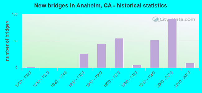
- New bridges - historical statistics
- 11920-1929
- 261950-1959
- 451960-1969
- 551970-1979
- 51980-1989
- 521990-1999
- 922000-2009
- 92010-2019
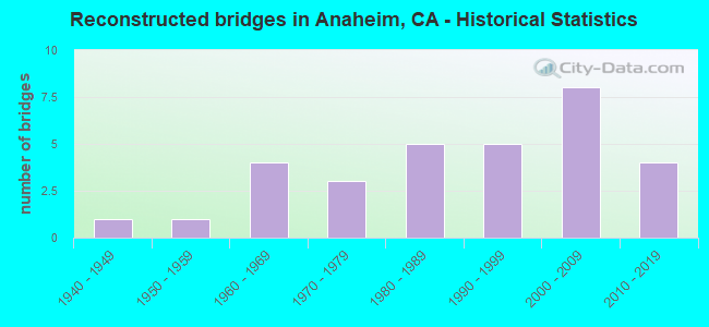
- Reconstructed bridges - Historical Statistics
- 11940-1949
- 11950-1959
- 41960-1969
- 31970-1979
- 51980-1989
- 51990-1999
- 82000-2009
- 42010-2019
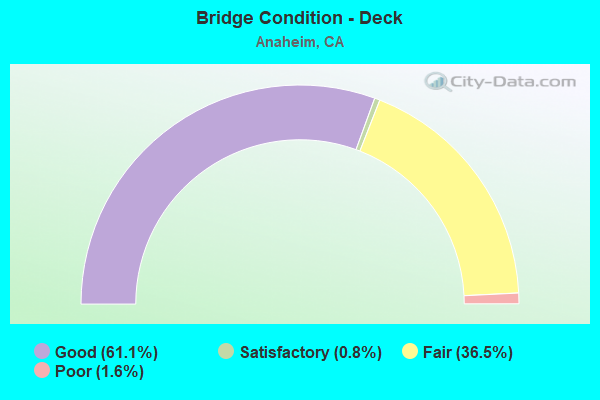
- Bridge Condition - Deck
- 61.1%Good
- 0.8%Satisfactory
- 36.5%Fair
- 1.6%Poor
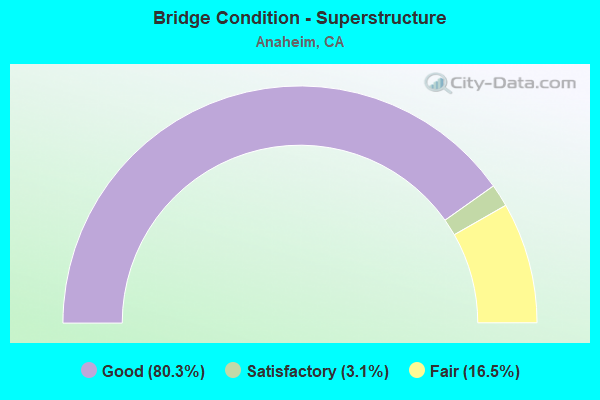
- Bridge Condition - Superstructure
- 80.3%Good
- 3.1%Satisfactory
- 16.5%Fair
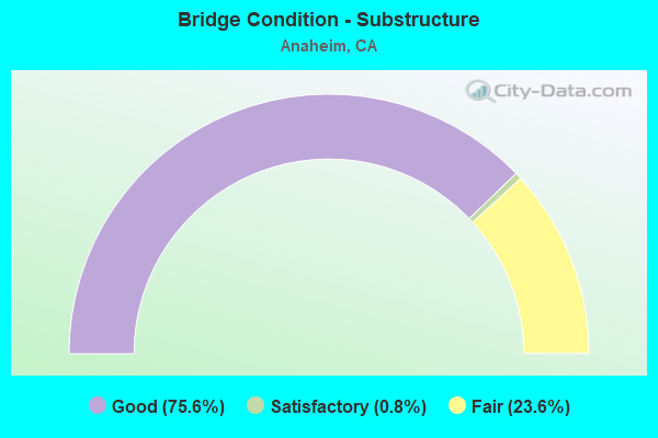
- Bridge Condition - Substructure
- 75.6%Good
- 0.8%Satisfactory
- 23.6%Fair
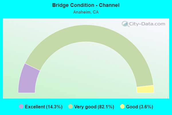
- Bridge Condition - Channel
- 14.3%Excellent
- 82.1%Very good
- 3.6%Good
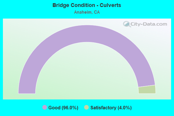
- Bridge Condition - Culverts
- 96.0%Good
- 4.0%Satisfactory
Find on map >> Show street view
Structure Number: 55 0835H, Location: 12-ORA-091-R3.56L-ANA (Lat: 33.857158, Lng: -117.982617), Route carried "on" structure: Alternate State highway 91, Year Built: 2000, Status: Open, Structure Length: 14.10m (46.26ft), Average Daily Traffic: 28,000 (year 2012), Truck Traffic: 7%, Average Future Daily Traffic: 30,800 (year 2040), Design Load: HS 20+Mod, Features Intersected: INTERSTATE 5
Minimum Vertical Clearance: 6.98m (22.90ft), Kilometerpoint: 3.560, Lanes on structure: 3, Lanes under structure: 6, Base Highway Network: Yes, Owner: State Highway Agency, Approaching Roadway Width: 21.9m (71.9ft), Skew: 39 degrees, Material/Design: Prestressed concrete continuous, Design/Construction: Box Beam or Girders - Multiple, Number Of Spans In Main Unit: 3, Length of Maximum Span: 55.2m (181.1ft), Curb-To-Curb Width: 21.9m (71.9ft), Out-to-Out Width: 23.6m (77.4ft)
Condition: Deck: Good, Superstructure: Good, Substructure: Good, Operating Rating: 54.1 metric tons, Method Used To Determine Operating Rating: Assigned rating based on Load Factor Design (LFD) reported in metric tons, Inventory Rating: 32.4 metric tons, Method Used To Determine Inventory Rating: Assigned rating based on Load Factor Design (LFD) reported in metric tons, Structural Evaluation: Better than present minimum criteria, Deck Geometry: Superior to present desirable criteria, Underclear: Meets minimum limits, Approach Roadway Alignment: Equal to present desirable criteria, Designated Inspection Frequency: Every 24 months, Inspection Date: December 2020, Deck Structure Type: Concrete Cast-file-Place
Find on map >> Show street view
Structure Number: 55 0837S, Location: 12-ORA-005-38.15-ANA (Lat: 33.821861, Lng: -117.922625), Route carried "on" structure: Ramp Interstate 5, Year Built: 2000, Status: Open, Structure Length: 15.13m (49.64ft), Average Daily Traffic: 9,598 (year 2015), Truck Traffic: 3%, Average Future Daily Traffic: 10,535 (year 2044), Design Load: HS 20+Mod, Features Intersected: INTERSTATE 5
Minimum Vertical Clearance: 30+ m (98+ ft), Kilometerpoint: 38.150, Lanes on structure: 2, Lanes under structure: 10, Base Highway Network: Yes, Owner: State Highway Agency, Approaching Roadway Width: 9.8m (32.2ft), Skew: 9 degrees, Material/Design: Prestressed concrete continuous, Design/Construction: Box Beam or Girders - Single/Spread, Number Of Spans In Main Unit: 3, Length of Maximum Span: 60.1m (197.2ft), Curb-To-Curb Width: 9.8m (32.2ft), Out-to-Out Width: 10.8m (35.4ft)
Condition: Deck: Fair, Superstructure: Good, Substructure: Good, Operating Rating: 54.1 metric tons, Method Used To Determine Operating Rating: Assigned rating based on Load Factor Design (LFD) reported in metric tons, Inventory Rating: 32.4 metric tons, Method Used To Determine Inventory Rating: Assigned rating based on Load Factor Design (LFD) reported in metric tons, Structural Evaluation: Better than present minimum criteria, Deck Geometry: Equal to present minimum criteria, Underclear: Meets minimum limits, Approach Roadway Alignment: Equal to present desirable criteria, Designated Inspection Frequency: Every 24 months, Inspection Date: January 2022, Deck Structure Type: Concrete Cast-file-Place
Find on map >> Show street view
Structure Number: 55 0841, Location: 12-ORA-005-39.31-ANA (Lat: 33.834461, Lng: -117.938883), Route carried "on" structure: Ramp Interstate 5, Year Built: 2000, Status: Open, Structure Length: 16.85m (55.28ft), Average Daily Traffic: 12,081 (year 2015), Truck Traffic: 3%, Average Future Daily Traffic: 14,876 (year 2039), Design Load: HS 20+Mod, Features Intersected: INTERSTATE 5
Minimum Vertical Clearance: 30+ m (98+ ft), Kilometerpoint: 39.310, Lanes on structure: 2, Lanes under structure: 10, Base Highway Network: Yes, Owner: State Highway Agency, Approaching Roadway Width: 11.0m (36.1ft), Skew: 9 degrees, Material/Design: Prestressed concrete continuous, Design/Construction: Box Beam or Girders - Single/Spread, Number Of Spans In Main Unit: 4, Length of Maximum Span: 54.9m (180.1ft), Curb-To-Curb Width: 11.0m (36.1ft), Out-to-Out Width: 12.0m (39.4ft)
Condition: Deck: Fair, Superstructure: Good, Substructure: Fair, Operating Rating: 54.1 metric tons, Method Used To Determine Operating Rating: Assigned rating based on Load Factor Design (LFD) reported in metric tons, Inventory Rating: 32.4 metric tons, Method Used To Determine Inventory Rating: Assigned rating based on Load Factor Design (LFD) reported in metric tons, Structural Evaluation: Somewhat better than minimum adequacy, Deck Geometry: Better than present minimum criteria, Underclear: Meets minimum limits, Approach Roadway Alignment: Equal to present desirable criteria, Designated Inspection Frequency: Every 24 months, Inspection Date: January 2022, Deck Structure Type: Concrete Cast-file-Place
Find on map >> Show street view
Structure Number: 55 0842, Location: 12-ORA-005-39.51-ANA (Lat: 33.834747, Lng: -117.941128), Route carried "on" structure: City street , Year Built: 2000, Status: Open, Structure Length: 13.92m (45.67ft), Average Daily Traffic: 48,000 (year 2012), Truck Traffic: 3%, Average Future Daily Traffic: 49,812 (year 2039), Design Load: HS 20+Mod, Features Intersected: INTERSTATE 5 & UP RR, Facility Carried by Structure: EUCLID STREET
Minimum Vertical Clearance: 30+ m (98+ ft), Kilometerpoint: 0.000, Lanes on structure: 9, Lanes under structure: 10, Owner: State Highway Agency, Approaching Roadway Width: 38.4m (126.0ft), Skew: 4 degrees, Material/Design: Prestressed concrete continuous, Design/Construction: Box Beam or Girders - Multiple, Number Of Spans In Main Unit: 3, Length of Maximum Span: 50.4m (165.4ft), Curb or Sidewalk Widths: Left: 1.8m (5.9ft), Right: 1.8m (5.9ft), Curb-To-Curb Width: 38.4m (126.0ft), Out-to-Out Width: 42.7m (140.1ft)
Condition: Deck: Fair, Superstructure: Good, Substructure: Fair, Operating Rating: 54.1 metric tons, Method Used To Determine Operating Rating: Assigned rating based on Load Factor Design (LFD) reported in metric tons, Inventory Rating: 32.4 metric tons, Method Used To Determine Inventory Rating: Assigned rating based on Load Factor Design (LFD) reported in metric tons, Structural Evaluation: Somewhat better than minimum adequacy, Deck Geometry: Better than present minimum criteria, Underclear: Meets minimum limits, Approach Roadway Alignment: Equal to present desirable criteria, Designated Inspection Frequency: Every 24 months, Inspection Date: January 2022, Deck Structure Type: Concrete Cast-file-Place
Find on map >> Show street view
Structure Number: 55 0843, Location: 12-ORA-005-39.56-ANA (Lat: 33.837964, Lng: -117.946439), Route carried "on" structure: Ramp Interstate 5, Year Built: 2000, Status: Open, Structure Length: 25.65m (84.15ft), Average Daily Traffic: 7,345 (year 2014), Truck Traffic: 3%, Average Future Daily Traffic: 8,399 (year 2039), Design Load: HS 20+Mod, Features Intersected: INTERSTATE 5
Minimum Vertical Clearance: 5.81m (19.06ft), Kilometerpoint: 39.560, Lanes on structure: 1, Lanes under structure: 10, Base Highway Network: Yes, Owner: State Highway Agency, Approaching Roadway Width: 7.3m (24.0ft), Skew: 9 degrees, Material/Design: Prestressed concrete continuous, Design/Construction: Box Beam or Girders - Multiple, Number Of Spans In Main Unit: 4, Length of Maximum Span: 70.8m (232.3ft), Curb-To-Curb Width: 7.3m (24.0ft), Out-to-Out Width: 11.4m (37.4ft)
Condition: Deck: Fair, Superstructure: Good, Substructure: Fair, Operating Rating: 54.1 metric tons, Method Used To Determine Operating Rating: Assigned rating based on Load Factor Design (LFD) reported in metric tons, Inventory Rating: 32.4 metric tons, Method Used To Determine Inventory Rating: Assigned rating based on Load Factor Design (LFD) reported in metric tons, Structural Evaluation: Somewhat better than minimum adequacy, Deck Geometry: Better than present minimum criteria, Underclear: Meets minimum limits, Approach Roadway Alignment: Equal to present desirable criteria, Designated Inspection Frequency: Every 24 months, Inspection Date: January 2022, Deck Structure Type: Concrete Cast-file-Place
Find on map >> Show street view
Structure Number: 55 0844, Location: 12-ORA-005-38.66-ANA (Lat: 33.829408, Lng: -117.929689), Route carried "on" structure: City street , Year Built: 2000, Status: Open, Structure Length: 10.24m (33.60ft), Average Daily Traffic: 22,000 (year 2015), Truck Traffic: 3%, Average Future Daily Traffic: 22,983 (year 2039), Design Load: HS 20+Mod, Features Intersected: INTERSTATE 5, Facility Carried by Structure: BROADWAY
Minimum Vertical Clearance: 4.90m (16.08ft), Kilometerpoint: 0.000, Lanes on structure: 5, Lanes under structure: 14, Owner: State Highway Agency, Approaching Roadway Width: 19.5m (64.0ft), Skew: 2 degrees, Material/Design: Prestressed concrete continuous, Design/Construction: Box Beam or Girders - Multiple, Number Of Spans In Main Unit: 2, Length of Maximum Span: 54.6m (179.1ft), Curb or Sidewalk Widths: Left: 1.8m (5.9ft), Right: 1.8m (5.9ft), Curb-To-Curb Width: 19.5m (64.0ft), Out-to-Out Width: 23.8m (78.1ft)
Condition: Deck: Good, Superstructure: Good, Substructure: Fair, Operating Rating: 54.1 metric tons, Method Used To Determine Operating Rating: Load Factor (LF), Inventory Rating: 32.4 metric tons, Method Used To Determine Inventory Rating: Load Factor (LF), Structural Evaluation: Somewhat better than minimum adequacy, Deck Geometry: Meets minimum limits, Underclear: High priority of corrective action, Approach Roadway Alignment: Equal to present desirable criteria, Designated Inspection Frequency: Every 24 months, Inspection Date: January 2022, Deck Structure Type: Concrete Cast-file-Place
Find on map >> Show street view
Structure Number: 55 0845, Location: 12-ORA-005-39.00-ANA (Lat: 33.832106, Lng: -117.932706), Route carried "on" structure: City street , Year Built: 2000, Status: Open, Structure Length: 12.91m (42.36ft), Average Daily Traffic: 34,000 (year 2015), Truck Traffic: 3%, Average Future Daily Traffic: 35,513 (year 2044), Design Load: HS 20+Mod, Features Intersected: INTERSTATE 5, Facility Carried by Structure: LINCOLN AVE
Minimum Vertical Clearance: 5.15m (16.90ft), Kilometerpoint: 0.000, Lanes on structure: 7, Lanes under structure: 13, Owner: State Highway Agency, Approaching Roadway Width: 29.2m (95.8ft), Skew: 34 degrees, Material/Design: Prestressed concrete continuous, Design/Construction: Box Beam or Girders - Multiple, Number Of Spans In Main Unit: 2, Length of Maximum Span: 65.5m (214.9ft), Curb or Sidewalk Widths: Left: 1.8m (5.9ft), Right: 1.8m (5.9ft), Curb-To-Curb Width: 29.2m (95.8ft), Out-to-Out Width: 33.5m (109.9ft)
Condition: Deck: Fair, Superstructure: Good, Substructure: Good, Operating Rating: 54.1 metric tons, Method Used To Determine Operating Rating: Assigned rating based on Load Factor Design (LFD) reported in metric tons, Inventory Rating: 32.4 metric tons, Method Used To Determine Inventory Rating: Assigned rating based on Load Factor Design (LFD) reported in metric tons, Structural Evaluation: Better than present minimum criteria, Deck Geometry: Somewhat better than minimum adequacy, Underclear: High priority of corrective action, Approach Roadway Alignment: Equal to present desirable criteria, Designated Inspection Frequency: Every 24 months, Inspection Date: January 2022, Deck Structure Type: Concrete Cast-file-Place
Find on map >> Show street view
Structure Number: 55 0847K, Location: 12-ORA-005-38.06-ANA (Lat: 33.822269, Lng: -117.922889), Route carried "on" structure: Ramp Interstate 5, Year Built: 2000, Status: Open, Structure Length: 29.50m (96.78ft), Average Daily Traffic: 1,749 (year 2015), Truck Traffic: 1%, Average Future Daily Traffic: 2,472 (year 2044), Design Load: HS 20+Mod, Features Intersected: INTERSTATE 5 SB
Minimum Vertical Clearance: 5.63m (18.47ft), Kilometerpoint: 38.060, Lanes on structure: 1, Lanes under structure: 5, Base Highway Network: Yes, Owner: State Highway Agency, Approaching Roadway Width: 7.3m (24.0ft), Skew: 9 degrees, Material/Design: Prestressed concrete continuous, Design/Construction: Box Beam or Girders - Multiple, Number Of Spans In Main Unit: 5, Length of Maximum Span: 68.0m (223.1ft), Curb-To-Curb Width: 7.3m (24.0ft), Out-to-Out Width: 8.4m (27.6ft)
Condition: Deck: Fair, Superstructure: Good, Substructure: Good, Operating Rating: 54.1 metric tons, Method Used To Determine Operating Rating: Assigned rating based on Load Factor Design (LFD) reported in metric tons, Inventory Rating: 32.4 metric tons, Method Used To Determine Inventory Rating: Assigned rating based on Load Factor Design (LFD) reported in metric tons, Structural Evaluation: Better than present minimum criteria, Deck Geometry: Better than present minimum criteria, Underclear: Meets minimum limits, Approach Roadway Alignment: Equal to present desirable criteria, Designated Inspection Frequency: Every 24 months, Inspection Date: January 2022, Deck Structure Type: Concrete Cast-file-Place
Find on map >> Show street view
Structure Number: 55 0850L, Location: 12-ORA-074-R2.26-SJCP (Lat: 33.519247, Lng: -117.624958), Route carried "on" structure: State highway 74, Year Built: 2014, Status: Open, Structure Length: 8.25m (27.07ft), Average Daily Traffic: 5,500 (year 2012), Truck Traffic: 4%, Average Future Daily Traffic: 11,000 (year 2042), Design Load: HS 20+Mod, Features Intersected: SAN JUAN CREEK
Minimum Vertical Clearance: 30+ m (98+ ft), Kilometerpoint: 2.260, Lanes on structure: 2, Base Highway Network: Yes (, Subroute: 1), Owner: State Highway Agency, Approaching Roadway Width: 11.2m (36.7ft), Skew: 2 degrees, Material/Design: Prestressed concrete continuous, Design/Construction: Box Beam or Girders - Multiple, Number Of Spans In Main Unit: 2, Length of Maximum Span: 41.8m (137.1ft), Curb or Sidewalk Widths: Left: 0.0m, Right: 5.2m (17.1ft), Curb-To-Curb Width: 11.2m (36.7ft), Out-to-Out Width: 17.8m (58.4ft)
Condition: Deck: Fair, Superstructure: Good, Substructure: Good, Channel: Very good, Operating Rating: 54.1 metric tons, Method Used To Determine Operating Rating: Assigned rating based on Load Factor Design (LFD) reported in metric tons, Inventory Rating: 32.4 metric tons, Method Used To Determine Inventory Rating: Assigned rating based on Load Factor Design (LFD) reported in metric tons, Structural Evaluation: Better than present minimum criteria, Deck Geometry: Equal to present minimum criteria, Waterway Adequacy: Equal to present desirable criteria, Approach Roadway Alignment: Equal to present desirable criteria, Designated Inspection Frequency: Every 24 months, Inspection Date: Febuary 2022, Deck Structure Type: Concrete Cast-file-Place
Find on map >> Show street view
Structure Number: 55 0852, Location: 12-ORA-091-5.26-ANA (Lat: 33.853983, Lng: -117.889558), Route carried "on" structure: State highway 91, Year Built: 1999, Status: Open, Structure Length: 4.42m (14.50ft), Average Daily Traffic: 265,000 (year 2012), Truck Traffic: 6%, Average Future Daily Traffic: 295,000 (year 2040), Design Load: HS 20+Mod, Features Intersected: STATE COLLEGE BLVD
Minimum Vertical Clearance: 30+ m (98+ ft), Kilometerpoint: 5.260, Lanes on structure: 9, Lanes under structure: 6, Base Highway Network: Yes (, Subroute: 1), Owner: State Highway Agency, Approaching Roadway Width: 46.7m (153.2ft), Skew: 30 degrees, Material/Design: Prestressed concrete, Design/Construction: Girder and Floorbeam System, Number Of Spans In Main Unit: 2, Length of Maximum Span: 22.1m (72.5ft), Curb-To-Curb Width: 46.7m (153.2ft), Out-to-Out Width: 48.4m (158.8ft)
Condition: Deck: Good, Superstructure: Good, Substructure: Good, Operating Rating: 54.1 metric tons, Method Used To Determine Operating Rating: Assigned rating based on Load Factor Design (LFD) reported in metric tons, Inventory Rating: 32.4 metric tons, Method Used To Determine Inventory Rating: Assigned rating based on Load Factor Design (LFD) reported in metric tons, Structural Evaluation: Better than present minimum criteria, Deck Geometry: Superior to present desirable criteria, Underclear: Equal to present minimum criteria, Approach Roadway Alignment: Equal to present desirable criteria, Designated Inspection Frequency: Every 24 months, Inspection Date: November 2021, Deck Structure Type: Concrete Cast-file-Place
Find on map >> Show street view
Structure Number: 55 0853, Location: 12-ORA-091-5.53-ANA (Lat: 33.854119, Lng: -117.884892), Route carried "on" structure: City street M181, Year Built: 1999, Status: Open, Structure Length: 8.99m (29.49ft), Average Daily Traffic: 10,000 (year 2012), Truck Traffic: 5%, Average Future Daily Traffic: 11,000 (year 2040), Design Load: HS 20+Mod, Features Intersected: STATE ROUTE 91, Facility Carried by Structure: PLACENTIA AVE
Minimum Vertical Clearance: 30+ m (98+ ft), Kilometerpoint: 0.000, Lanes on structure: 4, Lanes under structure: 13, Owner: State Highway Agency, Approaching Roadway Width: 15.8m (51.8ft), Material/Design: Prestressed concrete continuous, Design/Construction: Box Beam or Girders - Multiple, Number Of Spans In Main Unit: 2, Length of Maximum Span: 47.8m (156.8ft), Curb or Sidewalk Widths: Left: 1.5m (4.9ft), Right: 1.5m (4.9ft), Curb-To-Curb Width: 15.8m (51.8ft), Out-to-Out Width: 19.5m (64.0ft)
Condition: Deck: Good, Superstructure: Good, Substructure: Good, Operating Rating: 54.1 metric tons, Method Used To Determine Operating Rating: Assigned rating based on Load Factor Design (LFD) reported in metric tons, Inventory Rating: 32.4 metric tons, Method Used To Determine Inventory Rating: Assigned rating based on Load Factor Design (LFD) reported in metric tons, Structural Evaluation: Better than present minimum criteria, Deck Geometry: Meets minimum limits, Underclear: High priority of corrective action, Approach Roadway Alignment: Equal to present desirable criteria, Designated Inspection Frequency: Every 24 months, Inspection Date: November 2021, Deck Structure Type: Concrete Cast-file-Place
Find on map >> Show street view
Structure Number: 55 0854, Location: 12-ORA-091-5.89-ANA (Lat: 33.851797, Lng: -117.879131), Route carried "on" structure: City street , Year Built: 1999, Status: Open, Structure Length: 10.00m (32.81ft), Average Daily Traffic: 10,000 (year 2012), Truck Traffic: 3%, Average Future Daily Traffic: 11,222 (year 2040), Design Load: HS 20+Mod, Features Intersected: STATE ROUTE 91, Facility Carried by Structure: SUNKIST ST
Minimum Vertical Clearance: 6.35m (20.83ft), Kilometerpoint: 0.000, Lanes on structure: 4, Lanes under structure: 11, Owner: State Highway Agency, Approaching Roadway Width: 19.5m (64.0ft), Material/Design: Prestressed concrete continuous, Design/Construction: Box Beam or Girders - Multiple, Number Of Spans In Main Unit: 2, Length of Maximum Span: 56.0m (183.7ft), Curb or Sidewalk Widths: Left: 1.5m (4.9ft), Right: 1.5m (4.9ft), Curb-To-Curb Width: 19.5m (64.0ft), Out-to-Out Width: 23.2m (76.1ft)
Condition: Deck: Good, Superstructure: Good, Substructure: Good, Operating Rating: 54.1 metric tons, Method Used To Determine Operating Rating: Assigned rating based on Load Factor Design (LFD) reported in metric tons, Inventory Rating: 32.4 metric tons, Method Used To Determine Inventory Rating: Assigned rating based on Load Factor Design (LFD) reported in metric tons, Structural Evaluation: Better than present minimum criteria, Deck Geometry: Better than present minimum criteria, Underclear: High priority of corrective action, Approach Roadway Alignment: Equal to present desirable criteria, Designated Inspection Frequency: Every 24 months, Inspection Date: November 2021, Deck Structure Type: Concrete Cast-file-Place
Find on map >> Show street view
Structure Number: 55 0855, Location: 12-ORA-057-15.90-ANA (Lat: 33.853706, Lng: -117.876158), Route carried "on" structure: City street , Year Built: 1998, Status: Open, Structure Length: 11.89m (39.01ft), Average Daily Traffic: 10,000 (year 2011), Truck Traffic: 3%, Average Future Daily Traffic: 12,034 (year 2044), Design Load: HS 20+Mod, Features Intersected: STATE ROUTE 57, Facility Carried by Structure: MIRALOMA AVE
Minimum Vertical Clearance: 5.92m (19.42ft), Kilometerpoint: 0.000, Lanes on structure: 4, Lanes under structure: 14, Owner: State Highway Agency, Approaching Roadway Width: 19.5m (64.0ft), Skew: 22 degrees, Material/Design: Prestressed concrete continuous, Design/Construction: Box Beam or Girders - Multiple, Number Of Spans In Main Unit: 2, Length of Maximum Span: 63.4m (208.0ft), Curb or Sidewalk Widths: Left: 1.5m (4.9ft), Right: 1.5m (4.9ft), Curb-To-Curb Width: 19.5m (64.0ft), Out-to-Out Width: 23.2m (76.1ft)
Condition: Deck: Fair, Superstructure: Fair, Substructure: Fair, Operating Rating: 67.1 metric tons, Method Used To Determine Operating Rating: Load and Resistance Factor Rating (LRFR) rating reported by rating factor(RF) method using HL-93 loadings, Inventory Rating: 22.7 metric tons, Method Used To Determine Inventory Rating: Load and Resistance Factor Rating (LRFR) rating reported by rating factor(RF) method using HL-93 loadings, Structural Evaluation: Somewhat better than minimum adequacy, Deck Geometry: Better than present minimum criteria, Underclear: High priority of corrective action, Approach Roadway Alignment: Equal to present desirable criteria, Designated Inspection Frequency: Every 24 months, Inspection Date: January 2022, Deck Structure Type: Concrete Cast-file-Place
Find on map >> Show street view
Structure Number: 55 0856, Location: 12-ORA-057-16.13-ANA (Lat: 33.857289, Lng: -117.876447), Route carried "on" structure: City street , Year Built: 1998, Status: Open, Structure Length: 9.45m (31.00ft), Average Daily Traffic: 10,000 (year 2011), Truck Traffic: 3%, Average Future Daily Traffic: 12,034 (year 2044), Design Load: HS 20+Mod, Features Intersected: STATE ROUTE 57, Facility Carried by Structure: LA JOLLA ST
Minimum Vertical Clearance: 30+ m (98+ ft), Kilometerpoint: 0.000, Lanes on structure: 2, Lanes under structure: 18, Owner: State Highway Agency, Approaching Roadway Width: 10.9m (35.8ft), Skew: 20 degrees, Material/Design: Concrete continuous, Design/Construction: Box Beam or Girders - Multiple, Number Of Spans In Main Unit: 2, Length of Maximum Span: 47.2m (154.9ft), Curb or Sidewalk Widths: Left: 1.5m (4.9ft), Right: 1.5m (4.9ft), Curb-To-Curb Width: 10.9m (35.8ft), Out-to-Out Width: 14.6m (47.9ft)
Condition: Deck: Fair, Superstructure: Fair, Substructure: Good, Operating Rating: 54.1 metric tons, Method Used To Determine Operating Rating: Assigned rating based on Load Factor Design (LFD) reported in metric tons, Inventory Rating: 32.4 metric tons, Method Used To Determine Inventory Rating: Assigned rating based on Load Factor Design (LFD) reported in metric tons, Structural Evaluation: Somewhat better than minimum adequacy, Deck Geometry: Meets minimum limits, Underclear: High priority of corrective action, Approach Roadway Alignment: Equal to present desirable criteria, Designated Inspection Frequency: Every 24 months, Inspection Date: January 2022, Deck Structure Type: Concrete Cast-file-Place
Find on map >> Show street view
Structure Number: 55 0857, Location: 12-ORA-091-3.26-ANA (Lat: 33.854183, Lng: -117.924428), Route carried "on" structure: City street M005, Year Built: 2000, Status: Open, Structure Length: 7.66m (25.13ft), Average Daily Traffic: 30,000 (year 2011), Truck Traffic: 8%, Average Future Daily Traffic: 33,000 (year 2038), Design Load: HS 20+Mod, Features Intersected: STATE ROUTE 91, Facility Carried by Structure: HARBOR BLVD
Minimum Vertical Clearance: 30+ m (98+ ft), Kilometerpoint: 0.000, Lanes on structure: 8, Lanes under structure: 10, Owner: State Highway Agency, Approaching Roadway Width: 28.8m (94.5ft), Skew: 20 degrees, Material/Design: Prestressed concrete continuous, Design/Construction: Box Beam or Girders - Multiple, Number Of Spans In Main Unit: 2, Length of Maximum Span: 38.3m (125.7ft), Curb or Sidewalk Widths: Left: 1.8m (5.9ft), Right: 2.1m (6.9ft), Curb-To-Curb Width: 28.8m (94.5ft), Out-to-Out Width: 33.0m (108.3ft)
Condition: Deck: Good, Superstructure: Good, Substructure: Good, Operating Rating: 54.1 metric tons, Method Used To Determine Operating Rating: Assigned rating based on Load Factor Design (LFD) reported in metric tons, Inventory Rating: 32.4 metric tons, Method Used To Determine Inventory Rating: Assigned rating based on Load Factor Design (LFD) reported in metric tons, Structural Evaluation: Better than present minimum criteria, Deck Geometry: High priority of corrective action, Underclear: High priority of corrective action, Approach Roadway Alignment: Equal to present desirable criteria, Designated Inspection Frequency: Every 24 months, Inspection Date: August 2021, Deck Structure Type: Concrete Cast-file-Place
Find on map >> Show street view
Structure Number: 55 0858, Location: 12-ORA-091-3.51-ANA (Lat: 33.854433, Lng: -117.920061), Route carried "on" structure: City street M166, Year Built: 1999, Status: Open, Structure Length: 5.18m (16.99ft), Average Daily Traffic: 20,000 (year 2011), Truck Traffic: 5%, Average Future Daily Traffic: 22,000 (year 2038), Design Load: HS 20+Mod, Features Intersected: STATE ROUTE 91, Facility Carried by Structure: LEMON STREET
Minimum Vertical Clearance: 30+ m (98+ ft), Kilometerpoint: 0.000, Lanes on structure: 7, Lanes under structure: 10, Owner: State Highway Agency, Approaching Roadway Width: 29.2m (95.8ft), Skew: 20 degrees, Material/Design: Prestressed concrete continuous, Design/Construction: Box Beam or Girders - Multiple, Number Of Spans In Main Unit: 2, Length of Maximum Span: 26.0m (85.3ft), Curb or Sidewalk Widths: Left: 1.5m (4.9ft), Right: 2.1m (6.9ft), Curb-To-Curb Width: 29.2m (95.8ft), Out-to-Out Width: 33.5m (109.9ft)
Condition: Deck: Good, Superstructure: Good, Substructure: Fair, Operating Rating: 54.1 metric tons, Method Used To Determine Operating Rating: Assigned rating based on Load Factor Design (LFD) reported in metric tons, Inventory Rating: 32.4 metric tons, Method Used To Determine Inventory Rating: Assigned rating based on Load Factor Design (LFD) reported in metric tons, Structural Evaluation: Somewhat better than minimum adequacy, Deck Geometry: Somewhat better than minimum adequacy, Underclear: Equal to present minimum criteria, Approach Roadway Alignment: Equal to present desirable criteria, Designated Inspection Frequency: Every 24 months, Inspection Date: August 2021, Deck Structure Type: Concrete Cast-file-Place
Find on map >> Show street view
Structure Number: 55 0859, Location: 12-ORA-005-37.40-ANA (Lat: 33.814583, Lng: -117.915156), Route carried "on" structure: City street , Year Built: 2000, Status: Open, Structure Length: 13.45m (44.13ft), Average Daily Traffic: 41,000 (year 2012), Truck Traffic: 3%, Average Future Daily Traffic: 41,500 (year 2039), Design Load: HS 20+Mod, Features Intersected: INTERSTATE 5, Facility Carried by Structure: HARBOR BLVD
Minimum Vertical Clearance: 30+ m (98+ ft), Kilometerpoint: 0.000, Lanes on structure: 8, Lanes under structure: 13, Owner: State Highway Agency, Approaching Roadway Width: 28.0m (91.9ft), Skew: 35 degrees, Material/Design: Steel continuous, Design/Construction: Stringer/Multi-beam, Number Of Spans In Main Unit: 2, Length of Maximum Span: 70.6m (231.6ft), Curb or Sidewalk Widths: Left: 1.8m (5.9ft), Right: 1.8m (5.9ft), Curb-To-Curb Width: 28.0m (91.9ft), Out-to-Out Width: 36.9m (121.1ft)
Condition: Deck: Good, Superstructure: Good, Substructure: Good, Operating Rating: 54.1 metric tons, Method Used To Determine Operating Rating: Assigned rating based on Load Factor Design (LFD) reported in metric tons, Inventory Rating: 32.4 metric tons, Method Used To Determine Inventory Rating: Assigned rating based on Load Factor Design (LFD) reported in metric tons, Structural Evaluation: Better than present minimum criteria, Deck Geometry: High priority of replacement, Underclear: High priority of corrective action, Approach Roadway Alignment: Equal to present desirable criteria, Designated Inspection Frequency: Every 24 months, Inspection Date: January 2022, Deck Structure Type: Concrete Cast-file-Place
Find on map >> Show street view
Structure Number: 55 0901, Location: 12-ORA-005-40.93-ANA (Lat: 33.846786, Lng: -117.963506), Route carried "on" structure: City street , Year Built: 2002, Status: Open, Structure Length: 24.81m (81.40ft), Average Daily Traffic: 26,000 (year 2015), Truck Traffic: 3%, Average Future Daily Traffic: 28,945 (year 2044), Design Load: HS 20+Mod, Features Intersected: INTERSTATE 5,RAMPS,UP RR, Facility Carried by Structure: LA PALMA AVE
Minimum Vertical Clearance: 30+ m (98+ ft), Kilometerpoint: 0.000, Lanes on structure: 6, Lanes under structure: 10, Owner: State Highway Agency, Approaching Roadway Width: 23.8m (78.1ft), Skew: 35 degrees, Material/Design: Prestressed concrete continuous, Design/Construction: Box Beam or Girders - Multiple, Number Of Spans In Main Unit: 3, Length of Maximum Span: 99.4m (326.1ft), Curb or Sidewalk Widths: Left: 1.8m (5.9ft), Right: 1.8m (5.9ft), Curb-To-Curb Width: 23.8m (78.1ft), Out-to-Out Width: 32.0m (105.0ft)
Condition: Deck: Good, Superstructure: Fair, Substructure: Good, Operating Rating: 54.1 metric tons, Method Used To Determine Operating Rating: Assigned rating based on Load Factor Design (LFD) reported in metric tons, Inventory Rating: 32.4 metric tons, Method Used To Determine Inventory Rating: Assigned rating based on Load Factor Design (LFD) reported in metric tons, Structural Evaluation: Somewhat better than minimum adequacy, Deck Geometry: Somewhat better than minimum adequacy, Underclear: Meets minimum limits, Approach Roadway Alignment: Equal to present desirable criteria, Designated Inspection Frequency: Every 24 months, Inspection Date: January 2022, Deck Structure Type: Concrete Cast-file-Place
Find on map >> Show street view
Structure Number: 55 0902S, Location: 12-ORA-005-40.55-ANA (Lat: 33.844442, Lng: -117.957914), Route carried "on" structure: Ramp Interstate 5, Year Built: 2002, Status: Open, Structure Length: 14.98m (49.15ft), Average Daily Traffic: 14,373 (year 2014), Truck Traffic: 3%, Average Future Daily Traffic: 16,512 (year 2044), Design Load: HS 20+Mod, Features Intersected: INTERSTATE 5, RAMP
Minimum Vertical Clearance: 30+ m (98+ ft), Kilometerpoint: 40.550, Lanes on structure: 2, Lanes under structure: 10, Base Highway Network: Yes, Owner: State Highway Agency, Approaching Roadway Width: 9.8m (32.2ft), Skew: 9 degrees, Material/Design: Concrete continuous, Design/Construction: Box Beam or Girders - Single/Spread, Number Of Spans In Main Unit: 2, Length of Maximum Span: 80.0m (262.5ft), Curb-To-Curb Width: 9.8m (32.2ft), Out-to-Out Width: 10.8m (35.4ft)
Condition: Deck: Fair, Superstructure: Good, Substructure: Good, Operating Rating: 54.1 metric tons, Method Used To Determine Operating Rating: Assigned rating based on Load Factor Design (LFD) reported in metric tons, Inventory Rating: 32.4 metric tons, Method Used To Determine Inventory Rating: Assigned rating based on Load Factor Design (LFD) reported in metric tons, Structural Evaluation: Better than present minimum criteria, Deck Geometry: Equal to present minimum criteria, Underclear: Meets minimum limits, Approach Roadway Alignment: Equal to present desirable criteria, Designated Inspection Frequency: Every 24 months, Inspection Date: January 2022, Deck Structure Type: Concrete Cast-file-Place
Find on map >> Show street view
Structure Number: 55 0903Y, Location: 12-ORA-000--ANA (Lat: 33.844217, Lng: -117.958611), Route carried "on" structure: City street , Year Built: 2002, Status: Open, Structure Length: 3.48m (11.42ft), Average Daily Traffic: 47,000 (year 2010), Truck Traffic: 3%, Average Future Daily Traffic: 50,604 (year 2044), Design Load: HS 20+Mod, Features Intersected: UP RR, Facility Carried by Structure: BROOKHURST STREET
Minimum Vertical Clearance: 30+ m (98+ ft), Kilometerpoint: 0.000, Lanes on structure: 8, Owner: State Highway Agency, Approaching Roadway Width: 33.5m (109.9ft), Skew: 39 degrees, Material/Design: Prestressed concrete, Design/Construction: Box Beam or Girders - Multiple, Number Of Spans In Main Unit: 1, Length of Maximum Span: 34.8m (114.2ft), Curb or Sidewalk Widths: Left: 1.8m (5.9ft), Right: 1.8m (5.9ft), Curb-To-Curb Width: 33.5m (109.9ft), Out-to-Out Width: 45.1m (148.0ft)
Condition: Deck: Fair, Superstructure: Fair, Substructure: Good, Operating Rating: 54.1 metric tons, Method Used To Determine Operating Rating: Assigned rating based on Load Factor Design (LFD) reported in metric tons, Inventory Rating: 32.4 metric tons, Method Used To Determine Inventory Rating: Assigned rating based on Load Factor Design (LFD) reported in metric tons, Structural Evaluation: Somewhat better than minimum adequacy, Deck Geometry: Equal to present minimum criteria, Underclear: Better than present minimum criteria, Approach Roadway Alignment: Equal to present desirable criteria, Designated Inspection Frequency: Every 24 months, Inspection Date: January 2022, Deck Structure Type: Concrete Cast-file-Place
Find on map >> Show street view
Structure Number: 55 0904, Location: 12-ORA-005-40.72-ANA (Lat: 33.845003, Lng: -117.958725), Route carried "on" structure: City street , Year Built: 2002, Status: Open, Structure Length: 9.78m (32.09ft), Average Daily Traffic: 47,000 (year 2010), Truck Traffic: 3%, Average Future Daily Traffic: 50,604 (year 2044), Design Load: HS 20+Mod, Features Intersected: INTERSTATE 5, RAMP, Facility Carried by Structure: BROOKHURST STREET
Minimum Vertical Clearance: 30+ m (98+ ft), Kilometerpoint: 0.000, Lanes on structure: 7, Lanes under structure: 11, Owner: State Highway Agency, Approaching Roadway Width: 36.0m (118.1ft), Skew: 33 degrees, Material/Design: Prestressed concrete continuous, Design/Construction: Box Beam or Girders - Multiple, Number Of Spans In Main Unit: 2, Length of Maximum Span: 57.2m (187.7ft), Curb or Sidewalk Widths: Left: 1.8m (5.9ft), Right: 1.8m (5.9ft), Curb-To-Curb Width: 36.0m (118.1ft), Out-to-Out Width: 41.5m (136.2ft)
Condition: Deck: Fair, Superstructure: Good, Substructure: Good, Operating Rating: 54.1 metric tons, Method Used To Determine Operating Rating: Assigned rating based on Load Factor Design (LFD) reported in metric tons, Inventory Rating: 32.4 metric tons, Method Used To Determine Inventory Rating: Assigned rating based on Load Factor Design (LFD) reported in metric tons, Structural Evaluation: Better than present minimum criteria, Deck Geometry: Superior to present desirable criteria, Underclear: High priority of corrective action, Approach Roadway Alignment: Equal to present desirable criteria, Designated Inspection Frequency: Every 24 months, Inspection Date: January 2022, Deck Structure Type: Concrete Cast-file-Place
Find on map >> Show street view
Structure Number: 55 091, Location: 12-ORA-005-40.20-ANA (Lat: 33.841614, Lng: -117.951728), Route carried "on" structure: Interstate 5, Year Built: 2002, Status: Open, Structure Length: 0.98m (3.22ft), Average Daily Traffic: 259,800 (year 2016), Truck Traffic: 9%, Average Future Daily Traffic: 270,593 (year 2044), Features Intersected: CARBON CREEK
Minimum Vertical Clearance: 30+ m (98+ ft), Kilometerpoint: 40.200, Lanes on structure: 12, Base Highway Network: Yes (, Subroute: 1), Owner: State Highway Agency, Approaching Roadway Width: 61.0m (200.1ft), Skew: 9 degrees, Material/Design: Concrete, Design/Construction: Culvert, Number Of Spans In Main Unit: 2, Length of Maximum Span: 4.9m (16.1ft), Curb-To-Curb Width: 61.0m (200.1ft), Out-to-Out Width: 62.0m (203.4ft)
Condition: Channel: Very good, Culverts: Good, Operating Rating: 54.1 metric tons, Method Used To Determine Operating Rating: Field evaluation and documented engineering judgment, Inventory Rating: 32.4 metric tons, Method Used To Determine Inventory Rating: Field evaluation and documented engineering judgment, Structural Evaluation: Better than present minimum criteria, Deck Geometry: Superior to present desirable criteria, Waterway Adequacy: Equal to present minimum criteria, Approach Roadway Alignment: Equal to present desirable criteria, Designated Inspection Frequency: Every 24 months, Inspection Date: January 2022
Find on map >> Show street view
Structure Number: 55 0941F, Location: 12-ORA-091-R15.90-ANA (Lat: 33.862811, Lng: -117.716636), Route carried "on" structure: Ramp State highway 91, Year Built: 1998, Status: Open, Structure Length: 6.30m (20.67ft), Average Daily Traffic: 22,540 (year 2012), Truck Traffic: 5%, Average Future Daily Traffic: 25,384 (year 2040), Design Load: HS 20+Mod, Features Intersected: N241-W91 CONNECTOR
Minimum Vertical Clearance: 30+ m (98+ ft), Kilometerpoint: 15.900, Lanes on structure: 3, Lanes under structure: 2, Base Highway Network: Yes, Owner: State Highway Agency, Approaching Roadway Width: 15.6m (51.2ft), Skew: 3 degrees, Material/Design: Prestressed concrete, Design/Construction: Box Beam or Girders - Multiple, Number Of Spans In Main Unit: 1, Length of Maximum Span: 62.0m (203.4ft), Curb-To-Curb Width: 15.6m (51.2ft), Out-to-Out Width: 16.6m (54.5ft)
Condition: Deck: Fair, Superstructure: Good, Substructure: Good, Operating Rating: 54.1 metric tons, Method Used To Determine Operating Rating: Assigned rating based on Load Factor Design (LFD) reported in metric tons, Inventory Rating: 32.4 metric tons, Method Used To Determine Inventory Rating: Assigned rating based on Load Factor Design (LFD) reported in metric tons, Structural Evaluation: Better than present minimum criteria, Deck Geometry: Superior to present desirable criteria, Underclear: Equal to present desirable criteria, Approach Roadway Alignment: Better than present minimum criteria, Designated Inspection Frequency: Every 24 months, Inspection Date: November 2021, Deck Structure Type: Concrete Cast-file-Place
Find on map >> Show street view
Structure Number: 55 1058E, Location: 12-ORA-000--ANA (Lat: 33.799583, Lng: -117.896492), Route carried "on" structure: City street , Year Built: 2000, Status: Open, Structure Length: 4.94m (16.21ft), Average Daily Traffic: 3,000 (year 2015), Truck Traffic: 1%, Average Future Daily Traffic: 3,250 (year 2038), Design Load: HS 20+Mod, Features Intersected: SANTA CRUZ STREET, Facility Carried by Structure: GENE AUTRY WAY
Minimum Vertical Clearance: 30+ m (98+ ft), Kilometerpoint: 0.000, Lanes on structure: 6, Lanes under structure: 2, Owner: State Highway Agency, Approaching Roadway Width: 21.3m (69.9ft), Skew: 20 degrees, Material/Design: Prestressed concrete continuous, Design/Construction: Box Beam or Girders - Multiple, Number Of Spans In Main Unit: 3, Length of Maximum Span: 21.3m (69.9ft), Curb or Sidewalk Widths: Left: 1.5m (4.9ft), Right: 1.5m (4.9ft), Curb-To-Curb Width: 21.3m (69.9ft), Out-to-Out Width: 33.0m (108.3ft)
Condition: Deck: Good, Superstructure: Satisfactory, Substructure: Satisfactory, Operating Rating: 54.1 metric tons, Method Used To Determine Operating Rating: Assigned rating based on Load Factor Design (LFD) reported in metric tons, Inventory Rating: 32.4 metric tons, Method Used To Determine Inventory Rating: Assigned rating based on Load Factor Design (LFD) reported in metric tons, Structural Evaluation: Equal to present minimum criteria, Deck Geometry: High priority of replacement, Underclear: Meets minimum limits, Approach Roadway Alignment: Equal to present desirable criteria, Designated Inspection Frequency: Every 48 months, Inspection Date: January 2020, Deck Structure Type: Concrete Cast-file-Place
Find on map >> Show street view
Structure Number: 55 1064, Location: 12-ORA-090-12.25 (Lat: 33.863033, Lng: -117.790650), Route carried "on" structure: State highway 90, Year Built: 2010, Status: Open, Structure Length: 9.18m (30.12ft), Average Daily Traffic: 26,000 (year 2011), Truck Traffic: 5%, Average Future Daily Traffic: 31,418 (year 2038), Design Load: HS 20+Mod, Features Intersected: ESPERANZA RD,BNSF,AMTRAK
Minimum Vertical Clearance: 30+ m (98+ ft), Kilometerpoint: 12.250, Lanes on structure: 9, Lanes under structure: 8, Base Highway Network: Yes (, Subroute: 1), Owner: State Highway Agency, Approaching Roadway Width: 40.2m (131.9ft), Material/Design: Prestressed concrete continuous, Design/Construction: Box Beam or Girders - Multiple, Number Of Spans In Main Unit: 3, Length of Maximum Span: 37.0m (121.4ft), Curb or Sidewalk Widths: Left: 3.6m (11.8ft), Right: 0.0m, Curb-To-Curb Width: 40.2m (131.9ft), Out-to-Out Width: 45.2m (148.3ft)
Condition: Deck: Fair, Superstructure: Good, Substructure: Good, Operating Rating: 54.1 metric tons, Method Used To Determine Operating Rating: Assigned rating based on Load Factor Design (LFD) reported in metric tons, Inventory Rating: 32.4 metric tons, Method Used To Determine Inventory Rating: Assigned rating based on Load Factor Design (LFD) reported in metric tons, Structural Evaluation: Better than present minimum criteria, Deck Geometry: Better than present minimum criteria, Underclear: High priority of corrective action, Approach Roadway Alignment: Equal to present desirable criteria, Designated Inspection Frequency: Every 24 months, Inspection Date: April 2021, Deck Structure Type: Concrete Cast-file-Place
Find on map >> Show street view
Structure Number: 55 1082, Location: 12-ORA-022-R9.40-ANA (Lat: 33.778825, Lng: -117.896661), Route carried "on" structure: City street , Year Built: 2008, Status: Open, Structure Length: 6.58m (21.59ft), Average Daily Traffic: 9,000 (year 2020), Truck Traffic: 2%, Average Future Daily Traffic: 10,202 (year 2037), Design Load: HS 20+Mod, Features Intersected: STATE ROUTE 22, Facility Carried by Structure: LEWIS ST
Minimum Vertical Clearance: 30+ m (98+ ft), Kilometerpoint: 0.000, Lanes on structure: 4, Lanes under structure: 12, Owner: State Highway Agency, Approaching Roadway Width: 19.6m (64.3ft), Skew: 1 degrees, Material/Design: Prestressed concrete continuous, Design/Construction: Box Beam or Girders - Multiple, Number Of Spans In Main Unit: 2, Length of Maximum Span: 33.3m (109.3ft), Curb or Sidewalk Widths: Left: 1.5m (4.9ft), Right: 1.5m (4.9ft), Curb-To-Curb Width: 19.6m (64.3ft), Out-to-Out Width: 23.2m (76.1ft)
Condition: Deck: Fair, Superstructure: Good, Substructure: Fair, Operating Rating: 54.1 metric tons, Method Used To Determine Operating Rating: Assigned rating based on Load Factor Design (LFD) reported in metric tons, Inventory Rating: 32.4 metric tons, Method Used To Determine Inventory Rating: Assigned rating based on Load Factor Design (LFD) reported in metric tons, Structural Evaluation: Somewhat better than minimum adequacy, Deck Geometry: Better than present minimum criteria, Underclear: Meets minimum limits, Approach Roadway Alignment: Equal to present desirable criteria, Designated Inspection Frequency: Every 24 months, Inspection Date: April 2020, Deck Structure Type: Concrete Cast-file-Place
Find on map >> Show street view
Structure Number: 55 1085G, Location: 12-ORA-022-R10.66-ANA (Lat: 33.778000, Lng: -117.873519), Route carried "on" structure: Ramp State highway 22, Year Built: 2008, Status: Open, Structure Length: 4.50m (14.76ft), Average Daily Traffic: 11,000 (year 2020), Truck Traffic: 3%, Average Future Daily Traffic: 12,000 (year 2038), Design Load: HS 20+Mod, Features Intersected: N5-W22 CONNECTOR RAMP
Minimum Vertical Clearance: 30+ m (98+ ft), Kilometerpoint: 10.660, Lanes on structure: 2, Lanes under structure: 2, Owner: State Highway Agency, Approaching Roadway Width: 11.9m (39.0ft), Skew: 4 degrees, Material/Design: Prestressed concrete, Design/Construction: Box Beam or Girders - Multiple, Number Of Spans In Main Unit: 1, Length of Maximum Span: 45.0m (147.6ft), Curb-To-Curb Width: 11.9m (39.0ft), Out-to-Out Width: 12.9m (42.3ft)
Condition: Deck: Fair, Superstructure: Good, Substructure: Good, Operating Rating: 54.1 metric tons, Method Used To Determine Operating Rating: Assigned rating based on Load Factor Design (LFD) reported in metric tons, Inventory Rating: 32.4 metric tons, Method Used To Determine Inventory Rating: Assigned rating based on Load Factor Design (LFD) reported in metric tons, Structural Evaluation: Better than present minimum criteria, Deck Geometry: Superior to present desirable criteria, Underclear: Meets minimum limits, Approach Roadway Alignment: Equal to present desirable criteria, Designated Inspection Frequency: Every 24 months, Inspection Date: November 2020, Deck Structure Type: Concrete Cast-file-Place
Find on map >> Show street view
Structure Number: 55 1087F, Location: 12-ORA-005-34.53-ANA (Lat: 33.779456, Lng: -117.889158), Route carried "on" structure: Ramp Interstate 5, Year Built: 2008, Status: Open, Structure Length: 5.58m (18.31ft), Average Daily Traffic: 16,285 (year 2015), Truck Traffic: 4%, Average Future Daily Traffic: 17,614 (year 2042), Design Load: HS 20+Mod, Features Intersected: THE CITY DRIVE
Minimum Vertical Clearance: 30+ m (98+ ft), Kilometerpoint: 34.530, Lanes on structure: 2, Lanes under structure: 7, Owner: State Highway Agency, Approaching Roadway Width: 11.6m (38.1ft), Material/Design: Concrete, Design/Construction: Box Beam or Girders - Multiple, Number Of Spans In Main Unit: 1, Length of Maximum Span: 55.8m (183.1ft), Curb-To-Curb Width: 11.6m (38.1ft), Out-to-Out Width: 12.6m (41.3ft)
Condition: Deck: Fair, Superstructure: Good, Substructure: Good, Operating Rating: 54.1 metric tons, Method Used To Determine Operating Rating: Assigned rating based on Load Factor Design (LFD) reported in metric tons, Inventory Rating: 32.4 metric tons, Method Used To Determine Inventory Rating: Assigned rating based on Load Factor Design (LFD) reported in metric tons, Structural Evaluation: Better than present minimum criteria, Deck Geometry: Superior to present desirable criteria, Underclear: Meets minimum limits, Approach Roadway Alignment: Equal to present desirable criteria, Designated Inspection Frequency: Every 24 months, Inspection Date: January 2022, Deck Structure Type: Concrete Cast-file-Place
Find on map >> Show street view
Structure Number: 55C0017, Location: 0.7 MI E/O ROUTE 57 FWY. (Lat: 33.835442, Lng: -117.863925), Route carried "on" structure: County highway , Year Built: 1970, Year Reconstructed: 2014, Status: Open, Structure Length: 13.01m (42.68ft), Average Daily Traffic: 28,000 (year 2009), Truck Traffic: 4%, Average Future Daily Traffic: 84,259 (year 2043), Design Load: HS 20, Features Intersected: SANTA ANA RIVER CHANNEL, Facility Carried by Structure: LINCOLN AVENUE
Minimum Vertical Clearance: 30+ m (98+ ft), Kilometerpoint: 0.000, Lanes on structure: 6, Base Highway Network: Yes, Owner: County Highway Agency, Approaching Roadway Width: 28.0m (91.9ft), Material/Design: Concrete, Design/Construction: Tee Beam, Number Of Spans In Main Unit: 6, Length of Maximum Span: 23.8m (78.1ft), Curb or Sidewalk Widths: Left: 1.5m (4.9ft), Right: 1.5m (4.9ft), Curb-To-Curb Width: 28.0m (91.9ft), Out-to-Out Width: 31.6m (103.7ft)
Condition: Deck: Good, Superstructure: Good, Substructure: Good, Channel: Very good, Operating Rating: 92.0 metric tons, Method Used To Determine Operating Rating: Load Factor (LF), Inventory Rating: 55.4 metric tons, Method Used To Determine Inventory Rating: Load Factor (LF), Structural Evaluation: Better than present minimum criteria, Deck Geometry: Superior to present desirable criteria, Waterway Adequacy: Superior to present desirable criteria, Approach Roadway Alignment: Equal to present desirable criteria, Designated Inspection Frequency: Every 48 months, Inspection Date: December 2021, Deck Structure Type: Concrete Cast-file-Place
Find on map >> Show street view
Structure Number: 55C0071, Location: 0.1 MI. NW/O BEACH BLVD. (Lat: 33.883039, Lng: -118.000586), Route carried "on" structure: City street , Year Built: 1960, Year Reconstructed: 1967, Status: Open, Structure Length: 2.65m (8.69ft), Average Daily Traffic: 9,000 (year 2020), Truck Traffic: 1%, Average Future Daily Traffic: 17,000 (year 2040), Design Load: HS 20, Features Intersected: COYOTE CREEK CHANNEL, Facility Carried by Structure: STAGE ROAD
Minimum Vertical Clearance: 30+ m (98+ ft), Kilometerpoint: 0.000, Lanes on structure: 5, Owner: City or Municipal Highway Agency, Approaching Roadway Width: 19.5m (64.0ft), Skew: 2 degrees, Material/Design: Concrete continuous, Design/Construction: Slab, Number Of Spans In Main Unit: 2, Length of Maximum Span: 12.8m (42.0ft), Curb or Sidewalk Widths: Left: 0.6m (2.0ft), Right: 0.6m (2.0ft), Curb-To-Curb Width: 19.5m (64.0ft), Out-to-Out Width: 21.3m (69.9ft)
Condition: Deck: Good, Superstructure: Good, Substructure: Good, Channel: Excellent, Operating Rating: 63.5 metric tons, Method Used To Determine Operating Rating: Load Factor (LF), Inventory Rating: 38.2 metric tons, Method Used To Determine Inventory Rating: Load Factor (LF), Structural Evaluation: Better than present minimum criteria, Deck Geometry: Meets minimum limits, Waterway Adequacy: Superior to present desirable criteria, Approach Roadway Alignment: Equal to present desirable criteria, Designated Inspection Frequency: Every 48 months, Inspection Date: April 2020, Deck Structure Type: Concrete Cast-file-Place, Wearing Surface/Protective System: Wearing Surface: Bituminous
Find on map >> Show street view
Structure Number: 55C0072, Location: 0.4 MI. E/O EUCLID STREET (Lat: 33.803069, Lng: -117.934897), Route carried "on" structure: City street , Year Built: 1963, Year Reconstructed: 2011, Status: Open, Structure Length: 0.79m (2.59ft), Average Daily Traffic: 28,000 (year 2017), Truck Traffic: 1%, Average Future Daily Traffic: 58,866 (year 2039), Design Load: H 15, Features Intersected: ANAHEIM-BARBER CITY CHAN, Facility Carried by Structure: KATELLA AVENUE
Minimum Vertical Clearance: 30+ m (98+ ft), Kilometerpoint: 0.000, Lanes on structure: 6, Base Highway Network: Yes, Owner: City or Municipal Highway Agency, Approaching Roadway Width: 22.2m (72.8ft), Skew: 30 degrees, Material/Design: Concrete, Design/Construction: Culvert, Number Of Spans In Main Unit: 3, Length of Maximum Span: 2.4m (7.9ft), Curb or Sidewalk Widths: Left: 3.5m (11.5ft), Right: 3.1m (10.2ft), Curb-To-Curb Width: 22.2m (72.8ft), Out-to-Out Width: 36.9m (121.1ft)
Condition: Channel: Excellent, Culverts: Good, Operating Rating: 40.5 metric tons, Method Used To Determine Operating Rating: Field evaluation and documented engineering judgment, Inventory Rating: 24.3 metric tons, Method Used To Determine Inventory Rating: Field evaluation and documented engineering judgment, Structural Evaluation: Equal to present minimum criteria, Deck Geometry: Meets minimum limits, Waterway Adequacy: Superior to present desirable criteria, Approach Roadway Alignment: Equal to present desirable criteria, Designated Inspection Frequency: Every 24 months, Inspection Date: August 2021
Find on map >> Show street view
Structure Number: 55C0114, Location: 200' S/O ORANGETHORPE AVE (Lat: 33.867497, Lng: -117.842383), Route carried "on" structure: County highway , Year Built: 1967, Year Reconstructed: 2005, Status: Open, Structure Length: 2.25m (7.38ft), Average Daily Traffic: 25,300 (year 2017), Truck Traffic: 7%, Average Future Daily Traffic: 52,734 (year 2039), Features Intersected: ATWOOD CHANNEL, Facility Carried by Structure: TUSTIN AVENUE
Minimum Vertical Clearance: 30+ m (98+ ft), Kilometerpoint: 0.000, Lanes on structure: 8, Base Highway Network: Yes, Owner: City or Municipal Highway Agency, Approaching Roadway Width: 29.2m (95.8ft), Skew: 30 degrees, Material/Design: Concrete continuous, Design/Construction: Slab, Number Of Spans In Main Unit: 2, Length of Maximum Span: 11.0m (36.1ft), Curb or Sidewalk Widths: Left: 0.0m, Right: 2.3m (7.5ft), Curb-To-Curb Width: 29.2m (95.8ft), Out-to-Out Width: 34.7m (113.8ft)
Condition: Deck: Good, Superstructure: Good, Substructure: Good, Channel: Very good, Operating Rating: 32.4 metric tons, Method Used To Determine Operating Rating: Field evaluation and documented engineering judgment, Inventory Rating: 19.4 metric tons, Method Used To Determine Inventory Rating: Field evaluation and documented engineering judgment, Structural Evaluation: Meets minimum limits, Deck Geometry: Meets minimum limits, Waterway Adequacy: Superior to present desirable criteria, Approach Roadway Alignment: Equal to present desirable criteria, Designated Inspection Frequency: Every 24 months, Inspection Date: August 2021, Deck Structure Type: Concrete Cast-file-Place
Find on map >> Show street view
Structure Number: 55C027, Location: 0.2 MI. W/O VALLEY VIEW (Lat: 33.816931, Lng: -118.031986), Route carried "on" structure: City street , Year Built: 1958, Year Reconstructed: 1963, Status: Open, Structure Length: 2.01m (6.59ft), Average Daily Traffic: 21,000 (year 2017), Truck Traffic: 1%, Average Future Daily Traffic: 43,857 (year 2040), Design Load: HS 20, Features Intersected: CARBON CREEK CHANNEL, Facility Carried by Structure: BALL ROAD
Minimum Vertical Clearance: 30+ m (98+ ft), Kilometerpoint: 0.000, Lanes on structure: 4, Base Highway Network: Yes, Owner: City or Municipal Highway Agency, Approaching Roadway Width: 20.6m (67.6ft), Skew: 35 degrees, Material/Design: Prestressed concrete, Design/Construction: Slab, Number Of Spans In Main Unit: 1, Length of Maximum Span: 19.5m (64.0ft), Curb or Sidewalk Widths: Left: 1.5m (4.9ft), Right: 1.5m (4.9ft), Curb-To-Curb Width: 20.6m (67.6ft), Out-to-Out Width: 28.7m (94.2ft)
Condition: Deck: Good, Superstructure: Good, Substructure: Good, Channel: Excellent, Operating Rating: 74.5 metric tons, Method Used To Determine Operating Rating: Load Factor (LF), Inventory Rating: 32.4 metric tons, Method Used To Determine Inventory Rating: Load Factor (LF), Structural Evaluation: Better than present minimum criteria, Deck Geometry: Superior to present desirable criteria, Waterway Adequacy: Superior to present desirable criteria, Approach Roadway Alignment: Equal to present desirable criteria, Designated Inspection Frequency: Every 48 months, Inspection Date: May 2021, Deck Structure Type: Concrete Precast Panels, Wearing Surface/Protective System: Wearing Surface: Bituminous
Find on map >> Show street view
Structure Number: 55C0271, Location: 0.3 MI. N/O BALL ROAD (Lat: 33.821511, Lng: -118.010722), Route carried "on" structure: City street , Year Built: 1959, Status: Open, Structure Length: 1.10m (3.61ft), Average Daily Traffic: 24,400 (year 2009), Truck Traffic: 3%, Average Future Daily Traffic: 59,260 (year 2037), Design Load: HS 20, Features Intersected: CARBON CREEK CHANNEL, Facility Carried by Structure: KNOTT AVENUE
Minimum Vertical Clearance: 30+ m (98+ ft), Kilometerpoint: 0.000, Lanes on structure: 5, Base Highway Network: Yes, Owner: City or Municipal Highway Agency, Approaching Roadway Width: 25.6m (84.0ft), Material/Design: Prestressed concrete, Design/Construction: Slab, Number Of Spans In Main Unit: 1, Length of Maximum Span: 10.4m (34.1ft), Curb or Sidewalk Widths: Left: 1.3m (4.3ft), Right: 1.3m (4.3ft), Curb-To-Curb Width: 20.2m (66.3ft), Out-to-Out Width: 23.5m (77.1ft)
Condition: Deck: Good, Superstructure: Good, Substructure: Good, Channel: Excellent, Operating Rating: 92.0 metric tons, Method Used To Determine Operating Rating: Load Factor (LF), Inventory Rating: 32.4 metric tons, Method Used To Determine Inventory Rating: Load Factor (LF), Structural Evaluation: Better than present minimum criteria, Deck Geometry: Somewhat better than minimum adequacy, Waterway Adequacy: Superior to present desirable criteria, Approach Roadway Alignment: Equal to present desirable criteria, Designated Inspection Frequency: Every 48 months, Inspection Date: September 2019, Deck Structure Type: Concrete Precast Panels, Wearing Surface/Protective System: Wearing Surface: Bituminous
Find on map >> Show street view
Structure Number: 55C0272, Location: 200' S/O ORANGE AVENUE (Lat: 33.824114, Lng: -118.002056), Route carried "on" structure: City street , Year Built: 1959, Status: Open, Structure Length: 1.10m (3.61ft), Average Daily Traffic: 17,500 (year 2009), Truck Traffic: 1%, Average Future Daily Traffic: 44,445 (year 2037), Design Load: HS 20, Features Intersected: CARBON CREEK CHANNEL, Facility Carried by Structure: WESTERN AVENUE
Minimum Vertical Clearance: 30+ m (98+ ft), Kilometerpoint: 0.000, Lanes on structure: 4, Owner: City or Municipal Highway Agency, Approaching Roadway Width: 19.5m (64.0ft), Skew: 2 degrees, Material/Design: Prestressed concrete, Design/Construction: Slab, Number Of Spans In Main Unit: 1, Length of Maximum Span: 10.7m (35.1ft), Curb or Sidewalk Widths: Left: 1.3m (4.3ft), Right: 1.3m (4.3ft), Curb-To-Curb Width: 15.8m (51.8ft), Out-to-Out Width: 18.9m (62.0ft)
Condition: Deck: Good, Superstructure: Good, Substructure: Good, Channel: Very good, Operating Rating: 90.7 metric tons, Method Used To Determine Operating Rating: Load Factor (LF), Inventory Rating: 32.4 metric tons, Method Used To Determine Inventory Rating: Load Factor (LF), Structural Evaluation: Better than present minimum criteria, Deck Geometry: Meets minimum limits, Waterway Adequacy: Superior to present desirable criteria, Approach Roadway Alignment: Equal to present desirable criteria, Designated Inspection Frequency: Every 48 months, Inspection Date: September 2019, Deck Structure Type: Concrete Precast Panels, Wearing Surface/Protective System: Wearing Surface: Bituminous
Find on map >> Show street view
Structure Number: 55C0273, Location: 0.1 MI. E/O WESTERN AVE. (Lat: 33.824606, Lng: -118.000864), Route carried "on" structure: City street , Year Built: 1959, Status: Open, Structure Length: 1.76m (5.77ft), Average Daily Traffic: 14,800 (year 2010), Truck Traffic: 1%, Average Future Daily Traffic: 28,635 (year 2043), Design Load: HS 20, Features Intersected: CARBON CREEK CHANNEL, Facility Carried by Structure: ORANGE AVENUE
Minimum Vertical Clearance: 30+ m (98+ ft), Kilometerpoint: 0.000, Lanes on structure: 4, Owner: City or Municipal Highway Agency, Approaching Roadway Width: 19.2m (63.0ft), Skew: 6 degrees, Material/Design: Concrete, Design/Construction: Culvert, Number Of Spans In Main Unit: 1, Length of Maximum Span: 16.3m (53.5ft), Curb or Sidewalk Widths: Left: 1.8m (5.9ft), Right: 1.5m (4.9ft), Curb-To-Curb Width: 17.7m (58.1ft), Out-to-Out Width: 21.6m (70.9ft)
Condition: Channel: Very good, Culverts: Good, Operating Rating: 40.5 metric tons, Method Used To Determine Operating Rating: Field evaluation and documented engineering judgment, Inventory Rating: 24.3 metric tons, Method Used To Determine Inventory Rating: Field evaluation and documented engineering judgment, Structural Evaluation: Equal to present minimum criteria, Deck Geometry: Somewhat better than minimum adequacy, Waterway Adequacy: Equal to present desirable criteria, Approach Roadway Alignment: Equal to present desirable criteria, Designated Inspection Frequency: Every 24 months, Inspection Date: September 2021
Find on map >> Show street view
Structure Number: 55C0274, Location: 0.2 MI. S/O LINCOLN AVE. (Lat: 33.830008, Lng: -117.984633), Route carried "on" structure: City street , Year Built: 1959, Status: Open, Structure Length: 1.10m (3.61ft), Average Daily Traffic: 17,100 (year 2010), Truck Traffic: 1%, Average Future Daily Traffic: 37,444 (year 2043), Features Intersected: CARBON CREEK CHANNEL, Facility Carried by Structure: DALE AVENUE
Minimum Vertical Clearance: 30+ m (98+ ft), Kilometerpoint: 0.000, Lanes on structure: 4, Owner: City or Municipal Highway Agency, Approaching Roadway Width: 19.5m (64.0ft), Material/Design: Prestressed concrete, Design/Construction: Slab, Number Of Spans In Main Unit: 1, Length of Maximum Span: 10.4m (34.1ft), Curb or Sidewalk Widths: Left: 1.3m (4.3ft), Right: 1.3m (4.3ft), Curb-To-Curb Width: 15.8m (51.8ft), Out-to-Out Width: 18.9m (62.0ft)
Condition: Deck: Good, Superstructure: Good, Substructure: Good, Channel: Very good, Operating Rating: 47.3 metric tons, Method Used To Determine Operating Rating: Load and Resistance Factor Rating (LRFR) rating reported by rating factor(RF) method using HL-93 loadings, Inventory Rating: 29.2 metric tons, Method Used To Determine Inventory Rating: Load and Resistance Factor Rating (LRFR) rating reported by rating factor(RF) method using HL-93 loadings, Structural Evaluation: Better than present minimum criteria, Deck Geometry: Meets minimum limits, Waterway Adequacy: Equal to present desirable criteria, Approach Roadway Alignment: Equal to present desirable criteria, Designated Inspection Frequency: Every 24 months, Inspection Date: September 2021, Deck Structure Type: Concrete Precast Panels, Wearing Surface/Protective System: Wearing Surface: Bituminous
Find on map >> Show street view
Structure Number: 55C0275, Location: 0.3 MI. S/O CRESCENT AVE. (Lat: 33.834619, Lng: -117.975903), Route carried "on" structure: City street , Year Built: 1959, Year Reconstructed: 1981, Status: Open, Structure Length: 1.44m (4.72ft), Average Daily Traffic: 28,100 (year 2010), Truck Traffic: 1%, Average Future Daily Traffic: 59,077 (year 2043), Features Intersected: CARBON CREEK CHANNEL, Facility Carried by Structure: MAGNOLIA AVENUE
Minimum Vertical Clearance: 30+ m (98+ ft), Kilometerpoint: 0.000, Lanes on structure: 5, Base Highway Network: Yes, Owner: City or Municipal Highway Agency, Approaching Roadway Width: 23.2m (76.1ft), Skew: 4 degrees, Material/Design: Prestressed concrete, Design/Construction: Slab, Number Of Spans In Main Unit: 1, Length of Maximum Span: 13.6m (44.6ft), Curb or Sidewalk Widths: Left: 3.6m (11.8ft), Right: 1.3m (4.3ft), Curb-To-Curb Width: 23.2m (76.1ft), Out-to-Out Width: 31.1m (102.0ft)
Condition: Deck: Good, Superstructure: Good, Substructure: Good, Channel: Very good, Operating Rating: 34.0 metric tons, Method Used To Determine Operating Rating: Field evaluation and documented engineering judgment, Inventory Rating: 20.4 metric tons, Method Used To Determine Inventory Rating: Field evaluation and documented engineering judgment, Structural Evaluation: Somewhat better than minimum adequacy, Deck Geometry: Better than present minimum criteria, Waterway Adequacy: Superior to present desirable criteria, Approach Roadway Alignment: Equal to present desirable criteria, Designated Inspection Frequency: Every 24 months, Inspection Date: September 2021, Deck Structure Type: Concrete Precast Panels, Wearing Surface/Protective System: Wearing Surface: Bituminous
Find on map >> Show street view
Structure Number: 55C0278, Location: AT CITRON STREET (Lat: 33.847064, Lng: -117.929286), Route carried "on" structure: City street , Year Built: 1959, Status: Open, Structure Length: 1.07m (3.51ft), Average Daily Traffic: 23,800 (year 2019), Truck Traffic: 1%, Average Future Daily Traffic: 42,329 (year 2041), Design Load: HS 20, Features Intersected: CARBON CREEK CHANNEL, Facility Carried by Structure: LA PALMA AVENUE
Minimum Vertical Clearance: 30+ m (98+ ft), Kilometerpoint: 0.000, Lanes on structure: 4, Base Highway Network: Yes, Owner: City or Municipal Highway Agency, Approaching Roadway Width: 19.5m (64.0ft), Skew: 9 degrees, Material/Design: Concrete, Design/Construction: Culvert, Number Of Spans In Main Unit: 2, Length of Maximum Span: 3.4m (11.2ft), Curb or Sidewalk Widths: Left: 1.2m (3.9ft), Right: 2.1m (6.9ft), Curb-To-Curb Width: 19.5m (64.0ft), Out-to-Out Width: 22.5m (73.8ft)
Condition: Channel: Excellent, Culverts: Good, Operating Rating: 40.5 metric tons, Method Used To Determine Operating Rating: Field evaluation and documented engineering judgment, Inventory Rating: 24.3 metric tons, Method Used To Determine Inventory Rating: Field evaluation and documented engineering judgment, Structural Evaluation: Equal to present minimum criteria, Deck Geometry: Better than present minimum criteria, Waterway Adequacy: Superior to present desirable criteria, Approach Roadway Alignment: Equal to present desirable criteria, Designated Inspection Frequency: Every 24 months, Inspection Date: September 2021
Find on map >> Show street view
Structure Number: 55C0317, Location: 0.3 MI. W/O MILLER STREET (Lat: 33.859242, Lng: -117.854911), Route carried "on" structure: City street , Year Built: 1960, Status: Open, Structure Length: 1.49m (4.89ft), Average Daily Traffic: 11,600 (year 2017), Truck Traffic: 13%, Average Future Daily Traffic: 29,433 (year 2039), Design Load: HS 20, Features Intersected: CARBON CYN DIVERSION CHA, Facility Carried by Structure: MIRALOMA AVENUE
Minimum Vertical Clearance: 30+ m (98+ ft), Kilometerpoint: 0.000, Lanes on structure: 4, Owner: City or Municipal Highway Agency, Approaching Roadway Width: 19.2m (63.0ft), Skew: 1 degrees, Material/Design: Prestressed concrete, Design/Construction: Slab, Number Of Spans In Main Unit: 1, Length of Maximum Span: 14.6m (47.9ft), Curb or Sidewalk Widths: Left: 1.5m (4.9ft), Right: 1.5m (4.9ft), Curb-To-Curb Width: 15.7m (51.5ft), Out-to-Out Width: 19.5m (64.0ft)
Condition: Deck: Good, Superstructure: Good, Substructure: Good, Channel: Very good, Operating Rating: 69.0 metric tons, Method Used To Determine Operating Rating: Load Factor (LF), Inventory Rating: 32.4 metric tons, Method Used To Determine Inventory Rating: Load Factor (LF), Structural Evaluation: Better than present minimum criteria, Deck Geometry: Meets minimum limits, Waterway Adequacy: Superior to present desirable criteria, Approach Roadway Alignment: Equal to present desirable criteria, Designated Inspection Frequency: Every 24 months, Inspection Date: August 2021, Deck Structure Type: Concrete Cast-file-Place, Wearing Surface/Protective System: Wearing Surface: Bituminous