Bridge Statistics for Anaheim, California (CA)
Condition, Traffic, Stress, Structural Evaluation, Project Costs
- National Bridge Inventory (NBI) Statistics
- 285Number of bridges
- 4,925ft / 1,501mTotal length
- $11,835,000Total costs
- 26,273,322Total average daily traffic
- 1,612,373Total average daily truck traffic
- National Bridge Inventory (NBI) Registered Bridges for Anaheim
- No street view available for this location
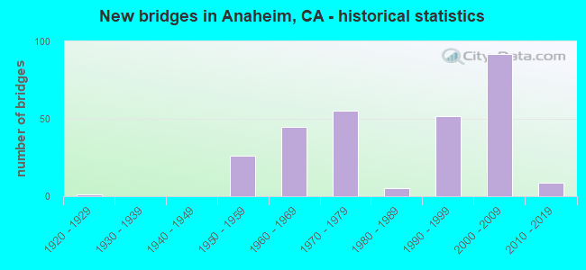
- New bridges - historical statistics
- 11920-1929
- 261950-1959
- 451960-1969
- 551970-1979
- 51980-1989
- 521990-1999
- 922000-2009
- 92010-2019
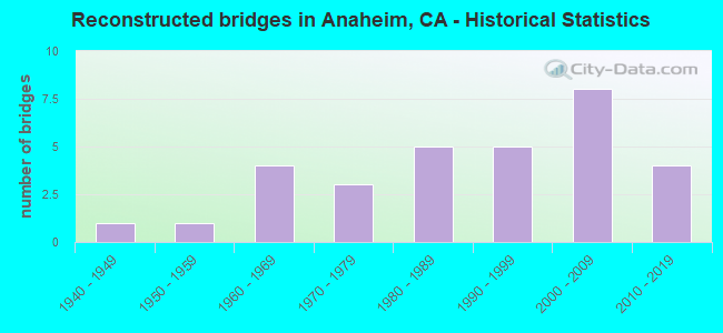
- Reconstructed bridges - Historical Statistics
- 11940-1949
- 11950-1959
- 41960-1969
- 31970-1979
- 51980-1989
- 51990-1999
- 82000-2009
- 42010-2019
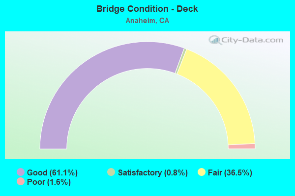
- Bridge Condition - Deck
- 61.1%Good
- 0.8%Satisfactory
- 36.5%Fair
- 1.6%Poor
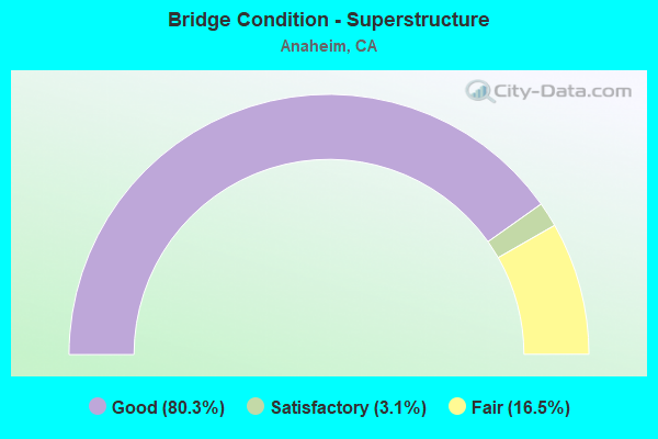
- Bridge Condition - Superstructure
- 80.3%Good
- 3.1%Satisfactory
- 16.5%Fair
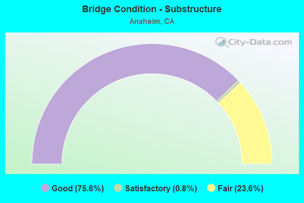
- Bridge Condition - Substructure
- 75.6%Good
- 0.8%Satisfactory
- 23.6%Fair
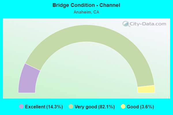
- Bridge Condition - Channel
- 14.3%Excellent
- 82.1%Very good
- 3.6%Good
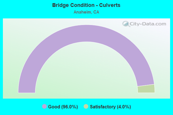
- Bridge Condition - Culverts
- 96.0%Good
- 4.0%Satisfactory
Find on map >> Show street view
Structure Number: 55 0446, Location: 12-ORA-057-15.58-ANA (Lat: 33.849314, Lng: -117.875617), Route carried "under" structure: State highway 91, Year Built: 1974, Structure Length: 0. m, Average Daily Traffic: 259,000 (year 2011), Features Intersected: STATE ROUTE 91, Facility Carried by Structure: STATE ROUTE 57
Minimum Vertical Clearance: 5.00m (16.40ft), Kilometerpoint: 5.960, Lanes on structure: 9, Lanes under structure: 10, Material/Design: Concrete continuous, Design/Construction: Box Beam or Girders - Multiple, Length of Maximum Span: 39.6m (129.9ft)
Find on map >> Show street view
Structure Number: 55 0446F, Location: 12-ORA-057-15.59-ANA (Lat: 33.849539, Lng: -117.876175), Route carried "under" structure: State highway 91, Year Built: 1969, Structure Length: 0. m, Average Daily Traffic: 259,000 (year 2011), Features Intersected: STATE ROUTE 91
Minimum Vertical Clearance: 5.10m (16.73ft), Kilometerpoint: 5.970, Lanes on structure: 1, Lanes under structure: 10, Material/Design: Concrete continuous, Design/Construction: Box Beam or Girders - Multiple, Length of Maximum Span: 40.5m (132.9ft)
Find on map >> Show street view
Structure Number: 55 0446G, Location: 12-ORA-057-15.57-ANA (Lat: 33.849275, Lng: -117.875519), Route carried "under" structure: State highway 91, Year Built: 1974, Structure Length: 0. m, Average Daily Traffic: 259,000 (year 2011), Features Intersected: STATE ROUTE 91
Minimum Vertical Clearance: 5.16m (16.93ft), Kilometerpoint: 5.950, Lanes on structure: 1, Lanes under structure: 10, Material/Design: Concrete continuous, Design/Construction: Box Beam or Girders - Multiple, Length of Maximum Span: 38.7m (127.0ft)
Find on map >> Show street view
Structure Number: 55 0447G, Location: 12-ORA-091-5.96-ANA (Lat: 33.850075, Lng: -117.877386), Route carried "under" structure: Ramp State highway 57, Year Built: 1969, Structure Length: 0. m, Average Daily Traffic: 20,300 (year 2012), Truck Traffic: 6%, Features Intersected: SR 91 & SR 57
Minimum Vertical Clearance: 4.59m (15.06ft), Kilometerpoint: 15.640, Lanes on structure: 2, Lanes under structure: 1, Material/Design: Concrete continuous, Design/Construction: Box Beam or Girders - Multiple, Length of Maximum Span: 42.7m (140.1ft)
Find on map >> Show street view
Structure Number: 55 0447G, Location: 12-ORA-091-5.96-ANA (Lat: 33.850075, Lng: -117.877386), Route carried "under" structure: Ramp State highway 91, Year Built: 1969, Structure Length: 0. m, Average Daily Traffic: 28,500 (year 2012), Truck Traffic: 9%, Features Intersected: SR 91 & SR 57
Minimum Vertical Clearance: 6.65m (21.82ft), Kilometerpoint: 5.960, Lanes on structure: 2, Lanes under structure: 1, Material/Design: Concrete continuous, Design/Construction: Box Beam or Girders - Multiple, Length of Maximum Span: 42.7m (140.1ft)
Find on map >> Show street view
Structure Number: 55 0447G, Location: 12-ORA-091-5.96-ANA (Lat: 33.850075, Lng: -117.877386), Route carried "under" structure: State highway 57, Year Built: 1969, Structure Length: 0. m, Average Daily Traffic: 273,000 (year 2012), Truck Traffic: 8%, Features Intersected: SR 91 & SR 57
Minimum Vertical Clearance: 4.85m (15.91ft), Kilometerpoint: 15.640, Lanes on structure: 2, Lanes under structure: 10, Material/Design: Concrete continuous, Design/Construction: Box Beam or Girders - Multiple, Length of Maximum Span: 42.7m (140.1ft)
Find on map >> Show street view
Structure Number: 55 0447G, Location: 12-ORA-091-5.96-ANA (Lat: 33.850075, Lng: -117.877386), Route carried "under" structure: State highway 91, Year Built: 1969, Structure Length: 0. m, Average Daily Traffic: 259,000 (year 2012), Features Intersected: SR 91 & SR 57
Minimum Vertical Clearance: 8.23m (27.00ft), Kilometerpoint: 5.960, Lanes on structure: 2, Lanes under structure: 9, Material/Design: Concrete continuous, Design/Construction: Box Beam or Girders - Multiple, Length of Maximum Span: 42.7m (140.1ft)
Find on map >> Show street view
Structure Number: 55 0448F, Location: 12-ORA-091-6.16-ANA (Lat: 33.847058, Lng: -117.876353), Route carried "under" structure: Ramp State highway 57, Year Built: 1974, Structure Length: 0. m, Average Daily Traffic: 13,900 (year 2012), Truck Traffic: 6%, Features Intersected: ROUTES 91, 57, & CONN'S
Minimum Vertical Clearance: 5.81m (19.06ft), Kilometerpoint: 15.560, Lanes on structure: 2, Lanes under structure: 1, Material/Design: Concrete continuous, Design/Construction: Box Beam or Girders - Multiple, Length of Maximum Span: 40.5m (132.9ft)
Find on map >> Show street view
Structure Number: 55 0448F, Location: 12-ORA-091-6.16-ANA (Lat: 33.847058, Lng: -117.876353), Route carried "under" structure: Ramp State highway 91, Year Built: 1974, Structure Length: 0. m, Average Daily Traffic: 28,500 (year 2012), Truck Traffic: 9%, Features Intersected: ROUTES 91, 57, & CONN'S
Minimum Vertical Clearance: 4.77m (15.65ft), Kilometerpoint: 6.160, Lanes on structure: 2, Lanes under structure: 1, Material/Design: Concrete continuous, Design/Construction: Box Beam or Girders - Multiple, Length of Maximum Span: 40.5m (132.9ft)
Find on map >> Show street view
Structure Number: 55 0448F, Location: 12-ORA-091-6.16-ANA (Lat: 33.847058, Lng: -117.876353), Route carried "under" structure: State highway 57, Year Built: 1974, Structure Length: 0. m, Average Daily Traffic: 229,000 (year 2012), Truck Traffic: 8%, Features Intersected: ROUTES 91, 57, & CONN'S
Minimum Vertical Clearance: 5.84m (19.16ft), Kilometerpoint: 15.560, Lanes on structure: 2, Lanes under structure: 10, Material/Design: Concrete continuous, Design/Construction: Box Beam or Girders - Multiple, Length of Maximum Span: 40.5m (132.9ft)
Find on map >> Show street view
Structure Number: 55 0448F, Location: 12-ORA-091-6.16-ANA (Lat: 33.847058, Lng: -117.876353), Route carried "under" structure: City street L073, Year Built: 1974, Structure Length: 0. m, Average Daily Traffic: 30,000 (year 2012), Truck Traffic: 6%, Features Intersected: ROUTES 91, 57, & CONN'S, Facility Carried by Structure: W91-S57 CONNECTOR
Minimum Vertical Clearance: 6.22m (20.41ft), Kilometerpoint: 0.000, Lanes on structure: 2, Lanes under structure: 4, Material/Design: Concrete continuous, Design/Construction: Box Beam or Girders - Multiple, Length of Maximum Span: 40.5m (132.9ft)
Find on map >> Show street view
Structure Number: 55 0448F, Location: 12-ORA-091-6.16-ANA (Lat: 33.847058, Lng: -117.876353), Route carried "under" structure: State highway 91, Year Built: 1974, Structure Length: 0. m, Average Daily Traffic: 225,000 (year 2012), Truck Traffic: 8%, Features Intersected: ROUTES 91, 57, & CONN'S
Minimum Vertical Clearance: 7.62m (25.00ft), Kilometerpoint: 6.160, Lanes on structure: 2, Lanes under structure: 9, Material/Design: Concrete continuous, Design/Construction: Box Beam or Girders - Multiple, Length of Maximum Span: 40.5m (132.9ft)
Find on map >> Show street view
Structure Number: 55 047, Location: 12-ORA-057-15.41-ANA (Lat: 33.847064, Lng: -117.875778), Route carried "under" structure: County highway L073, Year Built: 1974, Structure Length: 0. m, Average Daily Traffic: 20,000 (year 2010), Truck Traffic: 3%, Features Intersected: LA PALMA AVE, Facility Carried by Structure: STATE ROUTE 57
Minimum Vertical Clearance: 5.48m (17.98ft), Kilometerpoint: 0.000, Lanes on structure: 11, Lanes under structure: 4, Material/Design: Concrete continuous, Design/Construction: Box Beam or Girders - Multiple, Length of Maximum Span: 25.3m (83.0ft)
Find on map >> Show street view
Structure Number: 55 0470G, Location: 12-ORA-057-15.41-ANA (Lat: 33.847067, Lng: -117.875558), Route carried "under" structure: County highway L073, Year Built: 1974, Structure Length: 0. m, Average Daily Traffic: 20,000 (year 2010), Truck Traffic: 3%, Features Intersected: LA PALMA AVE, Facility Carried by Structure: N57-E91 CONNECTOR
Minimum Vertical Clearance: 4.90m (16.08ft), Kilometerpoint: 0.000, Lanes on structure: 2, Lanes under structure: 4, Material/Design: Concrete continuous, Design/Construction: Box Beam or Girders - Multiple, Length of Maximum Span: 27.4m (89.9ft)
Find on map >> Show street view
Structure Number: 55 0474, Location: 12-ORA-091-R11.53-ANA (Lat: 33.853989, Lng: -117.790806), Route carried "under" structure: State highway 90, Year Built: 1970, Structure Length: 0. m, Average Daily Traffic: 45,000 (year 2014), Truck Traffic: 5%, Features Intersected: STATE ROUTE 90, Facility Carried by Structure: STATE ROUTE 91
Minimum Vertical Clearance: 4.57m (14.99ft), Kilometerpoint: 12.820, Lanes on structure: 16, Lanes under structure: 8, Material/Design: Prestressed concrete, Design/Construction: Box Beam or Girders - Multiple, Length of Maximum Span: 46.3m (151.9ft)
Find on map >> Show street view
Structure Number: 55 0475, Location: 12-ORA-091-R10.09-ANA (Lat: 33.851147, Lng: -117.814733), Route carried "under" structure: State highway 91, Year Built: 1970, Structure Length: 0. m, Average Daily Traffic: 299,000 (year 2014), Truck Traffic: 5%, Features Intersected: STATE ROUTE 91, Facility Carried by Structure: LAKEVIEW AVE
Minimum Vertical Clearance: 4.83m (15.85ft), Kilometerpoint: 10.090, Lanes on structure: 4, Lanes under structure: 16, Material/Design: Prestressed concrete continuous, Design/Construction: Box Beam or Girders - Multiple, Length of Maximum Span: 44.8m (147.0ft)
Find on map >> Show street view
Structure Number: 55 0481, Location: 12-ORA-057-11.80-ANA (Lat: 33.795494, Lng: -117.877600), Route carried "under" structure: City street M111, Year Built: 1976, Structure Length: 0. m, Average Daily Traffic: 10,000 (year 2010), Truck Traffic: 3%, Features Intersected: ORANGEWOOD AVE, Facility Carried by Structure: STATE ROUTE 57
Minimum Vertical Clearance: 4.52m (14.83ft), Kilometerpoint: 0.000, Lanes on structure: 12, Lanes under structure: 7, Material/Design: Prestressed concrete, Design/Construction: Box Beam or Girders - Multiple, Length of Maximum Span: 57.9m (190.0ft)
Find on map >> Show street view
Structure Number: 55 0493R, Location: 12-ORA-091-R9.19-ANA (Lat: 33.844069, Lng: -117.827033), Route carried "under" structure: Alternate State highway 55, Year Built: 1970, Structure Length: 0. m, Average Daily Traffic: 29,000 (year 2014), Truck Traffic: 6%, Features Intersected: 91-55 FAST TRACK, Facility Carried by Structure: STATE ROUTE 91 EB
Minimum Vertical Clearance: 4.52m (14.83ft), Kilometerpoint: 17.830, Lanes on structure: 3, Lanes under structure: 2, Material/Design: Concrete, Design/Construction: Box Beam or Girders - Multiple, Length of Maximum Span: 39.3m (128.9ft)
Find on map >> Show street view
Structure Number: 55 0505L, Location: 12-ORA-091-R14.43L (Lat: 33.870503, Lng: -117.744956), Route carried "under" structure: County highway M009, Year Built: 1971, Structure Length: 0. m, Average Daily Traffic: 5,000 (year 2014), Truck Traffic: 6%, Features Intersected: WEIR CANYON RD, Facility Carried by Structure: STATE ROUTE 91 WB
Minimum Vertical Clearance: 4.80m (15.75ft), Kilometerpoint: 0.000, Lanes on structure: 8, Lanes under structure: 6, Material/Design: Concrete continuous, Design/Construction: Box Beam or Girders - Multiple, Length of Maximum Span: 22.9m (75.1ft)
Find on map >> Show street view
Structure Number: 55 0505R, Location: 12-ORA-091-R14.43R (Lat: 33.870019, Lng: -117.744639), Route carried "under" structure: County highway M009, Year Built: 1971, Structure Length: 0. m, Average Daily Traffic: 5,000 (year 2014), Truck Traffic: 6%, Features Intersected: WEIR CANYON RD, Facility Carried by Structure: STATE ROUTE 91 EB
Minimum Vertical Clearance: 4.80m (15.75ft), Kilometerpoint: 0.000, Lanes on structure: 8, Lanes under structure: 6, Material/Design: Concrete continuous, Design/Construction: Box Beam or Girders - Multiple, Length of Maximum Span: 24.1m (79.1ft)
Find on map >> Show street view
Structure Number: 55 0506, Location: 12-ORA-091-R16.40-ANA (Lat: 33.866539, Lng: -117.711592), Route carried "under" structure: City street , Year Built: 1971, Structure Length: 0. m, Average Daily Traffic: 10,000 (year 2014), Truck Traffic: 5%, Features Intersected: GYPSUM CANYON RD, Facility Carried by Structure: STATE ROUTE 91
Minimum Vertical Clearance: 4.57m (14.99ft), Kilometerpoint: 0.000, Lanes on structure: 14, Lanes under structure: 3, Material/Design: Prestressed concrete, Design/Construction: Box Beam or Girders - Multiple, Length of Maximum Span: 38.1m (125.0ft)
Find on map >> Show street view
Structure Number: 55 0515, Location: 12-ORA-057-13.92-ANA (Lat: 33.825297, Lng: -117.876456), Route carried "under" structure: State highway 57, Year Built: 1974, Structure Length: 0. m, Average Daily Traffic: 229,000 (year 2011), Truck Traffic: 8%, Features Intersected: STATE ROUTE 57, Facility Carried by Structure: WAGNER AVE
Minimum Vertical Clearance: 4.97m (16.31ft), Kilometerpoint: 13.920, Lanes on structure: 4, Lanes under structure: 11, Material/Design: Concrete continuous, Design/Construction: Box Beam or Girders - Multiple, Length of Maximum Span: 32.0m (105.0ft)
Find on map >> Show street view
Structure Number: 55 0516, Location: 12-ORA-057-14.42-ANA (Lat: 33.832561, Lng: -117.876472), Route carried "under" structure: State highway 57, Year Built: 1974, Structure Length: 0. m, Average Daily Traffic: 229,000 (year 2011), Truck Traffic: 8%, Features Intersected: STATE ROUTE 57, Facility Carried by Structure: SOUTH STREET
Minimum Vertical Clearance: 5.20m (17.06ft), Kilometerpoint: 14.420, Lanes on structure: 4, Lanes under structure: 11, Material/Design: Concrete continuous, Design/Construction: Box Beam or Girders - Multiple, Length of Maximum Span: 33.8m (110.9ft)
Find on map >> Show street view
Structure Number: 55 0524, Location: 12-ORA-057-13.42-ANA (Lat: 33.817953, Lng: -117.876697), Route carried "under" structure: State highway 57, Year Built: 1974, Structure Length: 0. m, Average Daily Traffic: 229,000 (year 2011), Truck Traffic: 8%, Features Intersected: STATE ROUTE 57, Facility Carried by Structure: BALL RD
Minimum Vertical Clearance: 5.23m (17.16ft), Kilometerpoint: 13.420, Lanes on structure: 6, Lanes under structure: 12, Material/Design: Concrete continuous, Design/Construction: Box Beam or Girders - Multiple, Length of Maximum Span: 36.3m (119.1ft)
Find on map >> Show street view
Structure Number: 55 0525, Location: 12-ORA-057-14.78-ANA (Lat: 33.837761, Lng: -117.876494), Route carried "under" structure: State highway 57, Year Built: 1974, Structure Length: 0. m, Average Daily Traffic: 229,000 (year 2011), Truck Traffic: 8%, Features Intersected: STATE ROUTE 57, Facility Carried by Structure: LINCOLN AVE
Minimum Vertical Clearance: 5.05m (16.57ft), Kilometerpoint: 14.780, Lanes on structure: 6, Lanes under structure: 13, Material/Design: Concrete continuous, Design/Construction: Box Beam or Girders - Multiple, Length of Maximum Span: 38.4m (126.0ft)
Find on map >> Show street view
Structure Number: 55 067, Location: 12-ORA-005-37.64-ANA (Lat: 33.817958, Lng: -117.919522), Route carried "under" structure: Interstate 5, Year Built: 1990, Structure Length: 0. m, Average Daily Traffic: 276,300 (year 2016), Truck Traffic: 7%, Features Intersected: INTERSTATE 5, Facility Carried by Structure: BALL ROAD
Minimum Vertical Clearance: 4.70m (15.42ft), Kilometerpoint: 37.640, Lanes on structure: 6, Lanes under structure: 11, Material/Design: Prestressed concrete continuous, Design/Construction: Box Beam or Girders - Multiple, Length of Maximum Span: 47.5m (155.8ft)
Find on map >> Show street view
Structure Number: 55 0713R, Location: 12-ORA-091-R9.17-ANA (Lat: 33.844144, Lng: -117.827492), Route carried "under" structure: Ramp State highway 91, Year Built: 1994, Structure Length: 0. m, Average Daily Traffic: 69,600 (year 2014), Truck Traffic: 6%, Features Intersected: W91-S55 CONNECTOR
Minimum Vertical Clearance: 5.43m (17.81ft), Kilometerpoint: 9.170, Lanes on structure: 3, Lanes under structure: 2, Material/Design: Concrete, Design/Construction: Slab, Length of Maximum Span: 25.1m (82.3ft)
Find on map >> Show street view
Structure Number: 55 0714, Location: 12-ORA-091-R9.91-ANA (Lat: 33.844367, Lng: -117.826839), Route carried "under" structure: Ramp State highway 91, Year Built: 1994, Structure Length: 0. m, Average Daily Traffic: 69,600 (year 2014), Truck Traffic: 6%, Features Intersected: W91-S55 CONNECTORS
Minimum Vertical Clearance: 5.56m (18.24ft), Kilometerpoint: 9.910, Lanes on structure: 2, Lanes under structure: 2, Material/Design: Prestressed concrete continuous, Design/Construction: Box Beam or Girders - Multiple, Length of Maximum Span: 37.5m (123.0ft)
Find on map >> Show street view
Structure Number: 55 0714, Location: 12-ORA-091-R9.91-ANA (Lat: 33.844367, Lng: -117.826839), Route carried "under" structure: Ramp State highway 91, Year Built: 1994, Structure Length: 0. m, Average Daily Traffic: 10,000 (year 2014), Truck Traffic: 1%, Features Intersected: W91-S55 CONNECTORS
Minimum Vertical Clearance: 5.56m (18.24ft), Kilometerpoint: 9.910, Lanes on structure: 2, Lanes under structure: 1, Material/Design: Prestressed concrete continuous, Design/Construction: Box Beam or Girders - Multiple, Length of Maximum Span: 37.5m (123.0ft)
Find on map >> Show street view
Structure Number: 55 0790G, Location: 12-ORA-241-38.76-ANA (Lat: 33.865389, Lng: -117.717961), Route carried "under" structure: City street , Year Built: 1998, Structure Length: 0. m, Average Daily Traffic: 17,700 (year 2012), Truck Traffic: 2%, Features Intersected: STATE ROUTE 91, Facility Carried by Structure: N241-W91 CONNECTOR
Minimum Vertical Clearance: 7.62m (25.00ft), Kilometerpoint: 0.000, Lanes on structure: 2, Lanes under structure: 2, Material/Design: Prestressed concrete continuous, Design/Construction: Box Beam or Girders - Multiple, Length of Maximum Span: 71.0m (232.9ft)
Find on map >> Show street view
Structure Number: 55 0790G, Location: 12-ORA-241-38.76-ANA (Lat: 33.865389, Lng: -117.717961), Route carried "under" structure: State highway 91, Year Built: 1998, Structure Length: 0. m, Average Daily Traffic: 263,000 (year 2012), Truck Traffic: 8%, Features Intersected: STATE ROUTE 91
Minimum Vertical Clearance: 7.01m (23.00ft), Kilometerpoint: 15.700, Lanes on structure: 2, Lanes under structure: 12, Material/Design: Prestressed concrete continuous, Design/Construction: Box Beam or Girders - Multiple, Length of Maximum Span: 71.0m (232.9ft)
Find on map >> Show street view
Structure Number: 55 0791G, Location: 12-ORA-241-38.84-ANA (Lat: 33.864825, Lng: -117.713306), Route carried "under" structure: Ramp State highway 91, Year Built: 1998, Structure Length: 0. m, Average Daily Traffic: 2,500 (year 2012), Truck Traffic: 2%, Features Intersected: SR 91 RAMPS & GYPSUM CYN
Minimum Vertical Clearance: 7.62m (25.00ft), Kilometerpoint: 16.350, Lanes on structure: 2, Lanes under structure: 2, Material/Design: Prestressed concrete continuous, Design/Construction: Box Beam or Girders - Multiple, Length of Maximum Span: 65.0m (213.3ft)
Find on map >> Show street view
Structure Number: 55 0791G, Location: 12-ORA-241-38.84-ANA (Lat: 33.864825, Lng: -117.713306), Route carried "under" structure: Ramp State highway 91, Year Built: 1998, Structure Length: 0. m, Average Daily Traffic: 4,700 (year 2012), Truck Traffic: 2%, Features Intersected: SR 91 RAMPS & GYPSUM CYN
Minimum Vertical Clearance: 6.55m (21.49ft), Kilometerpoint: 16.370, Lanes on structure: 2, Lanes under structure: 2, Material/Design: Prestressed concrete continuous, Design/Construction: Box Beam or Girders - Multiple, Length of Maximum Span: 65.0m (213.3ft)
Find on map >> Show street view
Structure Number: 55 0791G, Location: 12-ORA-241-38.84-ANA (Lat: 33.864825, Lng: -117.713306), Route carried "under" structure: Ramp State highway 91, Year Built: 1998, Structure Length: 0. m, Average Daily Traffic: 4,800 (year 2012), Truck Traffic: 2%, Features Intersected: SR 91 RAMPS & GYPSUM CYN
Minimum Vertical Clearance: 10.03m (32.91ft), Kilometerpoint: 16.430, Lanes on structure: 2, Lanes under structure: 2, Material/Design: Prestressed concrete continuous, Design/Construction: Box Beam or Girders - Multiple, Length of Maximum Span: 65.0m (213.3ft)
Find on map >> Show street view
Structure Number: 55 0794F, Location: 12-ORA-091-R16.31-ANA (Lat: 33.865056, Lng: -117.715253), Route carried "under" structure: State highway 91, Year Built: 1998, Structure Length: 0. m, Average Daily Traffic: 263,000 (year 2014), Truck Traffic: 8%, Features Intersected: STATE ROUTE 91
Minimum Vertical Clearance: 7.62m (25.00ft), Kilometerpoint: 16.310, Lanes on structure: 2, Lanes under structure: 10, Material/Design: Prestressed concrete continuous, Design/Construction: Box Beam or Girders - Multiple, Length of Maximum Span: 79.0m (259.2ft)
Find on map >> Show street view
Structure Number: 55 0794F, Location: 12-ORA-091-R16.31-ANA (Lat: 33.865056, Lng: -117.715253), Route carried "under" structure: Ramp State highway 91, Year Built: 1998, Structure Length: 0. m, Average Daily Traffic: 2,120 (year 2014), Truck Traffic: 5%, Features Intersected: STATE ROUTE 91
Minimum Vertical Clearance: 7.62m (25.00ft), Kilometerpoint: 16.500, Lanes on structure: 2, Lanes under structure: 1, Material/Design: Prestressed concrete continuous, Design/Construction: Box Beam or Girders - Multiple, Length of Maximum Span: 79.0m (259.2ft)
Find on map >> Show street view
Structure Number: 55 0794F, Location: 12-ORA-091-R16.31-ANA (Lat: 33.865056, Lng: -117.715253), Route carried "under" structure: Ramp State highway 91, Year Built: 1998, Structure Length: 0. m, Average Daily Traffic: 3,500 (year 2014), Truck Traffic: 5%, Features Intersected: STATE ROUTE 91
Minimum Vertical Clearance: 7.62m (25.00ft), Kilometerpoint: 16.600, Lanes on structure: 2, Lanes under structure: 1, Material/Design: Prestressed concrete continuous, Design/Construction: Box Beam or Girders - Multiple, Length of Maximum Span: 79.0m (259.2ft)
Find on map >> Show street view
Structure Number: 55 0794F, Location: 12-ORA-091-R16.31-ANA (Lat: 33.865056, Lng: -117.715253), Route carried "under" structure: Ramp State highway 91, Year Built: 1998, Structure Length: 0. m, Average Daily Traffic: 2,460 (year 2014), Truck Traffic: 5%, Features Intersected: STATE ROUTE 91
Minimum Vertical Clearance: 5.86m (19.23ft), Kilometerpoint: 16.700, Lanes on structure: 2, Lanes under structure: 1, Material/Design: Prestressed concrete continuous, Design/Construction: Box Beam or Girders - Multiple, Length of Maximum Span: 79.0m (259.2ft)
Find on map >> Show street view
Structure Number: 55 0814, Location: 12-ORA-005-35.19-ANA (Lat: 33.792028, Lng: -117.889622), Route carried "under" structure: City street , Year Built: 2000, Structure Length: 0. m, Average Daily Traffic: 34,000 (year 2018), Truck Traffic: 3%, Features Intersected: STATE COLLEGE BLVD, Facility Carried by Structure: INTERSTATE 5
Minimum Vertical Clearance: 5.53m (18.14ft), Kilometerpoint: 0.000, Lanes on structure: 17, Lanes under structure: 12, Material/Design: Concrete continuous, Design/Construction: Box Beam or Girders - Multiple, Length of Maximum Span: 45.7m (149.9ft)
Find on map >> Show street view
Structure Number: 55 0815K, Location: 12-ORA-005-35.42-ANA (Lat: 33.794183, Lng: -117.893536), Route carried "under" structure: Ramp Interstate 5, Year Built: 2000, Structure Length: 0. m, Average Daily Traffic: 4,640 (year 2015), Truck Traffic: 3%, Features Intersected: ORANGEWOOD AVE
Minimum Vertical Clearance: 5.84m (19.16ft), Kilometerpoint: 35.420, Lanes on structure: 1, Lanes under structure: 1, Material/Design: Prestressed concrete continuous, Design/Construction: Box Beam or Girders - Multiple, Length of Maximum Span: 56.4m (185.0ft)
Find on map >> Show street view
Structure Number: 55 0815K, Location: 12-ORA-005-35.42-ANA (Lat: 33.794183, Lng: -117.893536), Route carried "under" structure: City street , Year Built: 2000, Structure Length: 0. m, Average Daily Traffic: 29,000 (year 2018), Truck Traffic: 3%, Features Intersected: ORANGEWOOD AVE, Facility Carried by Structure: S5-STATE COL OFF-R
Minimum Vertical Clearance: 5.00m (16.40ft), Kilometerpoint: 0.000, Lanes on structure: 1, Lanes under structure: 8, Material/Design: Prestressed concrete continuous, Design/Construction: Box Beam or Girders - Multiple, Length of Maximum Span: 56.4m (185.0ft)
Find on map >> Show street view
Structure Number: 55 0816, Location: 12-ORA-005-35.59-ANA (Lat: 33.795939, Lng: -117.893908), Route carried "under" structure: City street , Year Built: 2000, Structure Length: 0. m, Average Daily Traffic: 29,000 (year 2018), Truck Traffic: 3%, Features Intersected: ORANGEWOOD AVE, Facility Carried by Structure: INTERSTATE 5
Minimum Vertical Clearance: 5.18m (16.99ft), Kilometerpoint: 0.000, Lanes on structure: 14, Lanes under structure: 6, Material/Design: Concrete continuous, Design/Construction: Box Beam or Girders - Multiple, Length of Maximum Span: 37.4m (122.7ft)
Find on map >> Show street view
Structure Number: 55 0818L, Location: 12-ORA-005-35.92-ANA (Lat: 33.799581, Lng: -117.899567), Route carried "under" structure: Interstate 5, Year Built: 2000, Structure Length: 0. m, Average Daily Traffic: 267,000 (year 2016), Truck Traffic: 7%, Features Intersected: INTERSTATE 5 SB, Facility Carried by Structure: GENE AUTRY WAY
Minimum Vertical Clearance: 6.04m (19.82ft), Kilometerpoint: 35.920, Lanes on structure: 7, Lanes under structure: 6, Material/Design: Prestressed concrete continuous, Design/Construction: Box Beam or Girders - Multiple, Length of Maximum Span: 53.9m (176.8ft)
Find on map >> Show street view
Structure Number: 55 0818R, Location: 12-ORA-005-35.92-ANA (Lat: 33.799567, Lng: -117.898011), Route carried "under" structure: Interstate 5, Year Built: 2000, Structure Length: 0. m, Average Daily Traffic: 267,000 (year 2016), Truck Traffic: 7%, Features Intersected: INTERSTATE 5 NB, Facility Carried by Structure: HOV-GENE AUTRY WAY
Minimum Vertical Clearance: 5.84m (19.16ft), Kilometerpoint: 35.920, Lanes on structure: 8, Lanes under structure: 6, Material/Design: Prestressed concrete continuous, Design/Construction: Box Beam or Girders - Multiple, Length of Maximum Span: 61.3m (201.1ft)
Find on map >> Show street view
Structure Number: 55 0819S, Location: 12-ORA-005-36.05-ANA (Lat: 33.801269, Lng: -117.898844), Route carried "under" structure: Ramp Interstate 5, Year Built: 2000, Structure Length: 0. m, Average Daily Traffic: 16,331 (year 2015), Truck Traffic: 3%, Features Intersected: N5-KATELLE OFF-RAMP
Minimum Vertical Clearance: 5.18m (16.99ft), Kilometerpoint: 36.050, Lanes on structure: 2, Lanes under structure: 3, Material/Design: Prestressed concrete continuous, Design/Construction: Box Beam or Girders - Single/Spread, Length of Maximum Span: 51.5m (169.0ft)
Find on map >> Show street view
Structure Number: 55 082, Location: 12-ORA-005-36.15-ANA (Lat: 33.803139, Lng: -117.901300), Route carried "under" structure: City street , Year Built: 2000, Structure Length: 0. m, Average Daily Traffic: 31,000 (year 2018), Truck Traffic: 3%, Features Intersected: KATELLA AVENUE, Facility Carried by Structure: INTERSTATE 5
Minimum Vertical Clearance: 5.41m (17.75ft), Kilometerpoint: 0.000, Lanes on structure: 15, Lanes under structure: 6, Material/Design: Prestressed concrete continuous, Design/Construction: Box Beam or Girders - Multiple, Length of Maximum Span: 35.1m (115.2ft)
Find on map >> Show street view
Structure Number: 55 0820J, Location: 12-ORA-005-36.15-ANA (Lat: 33.802939, Lng: -117.903067), Route carried "under" structure: City street , Year Built: 2000, Structure Length: 0. m, Average Daily Traffic: 31,000 (year 2018), Truck Traffic: 3%, Features Intersected: KATELLA AVENUE, Facility Carried by Structure: S5-KATELLA OFF-RP
Minimum Vertical Clearance: 5.43m (17.81ft), Kilometerpoint: 0.000, Lanes on structure: 2, Lanes under structure: 8, Material/Design: Prestressed concrete continuous, Design/Construction: Box Beam or Girders - Multiple, Length of Maximum Span: 53.3m (174.9ft)
Find on map >> Show street view
Structure Number: 55 0820K, Location: 12-ORA-005-36.15-ANA (Lat: 33.802736, Lng: -117.902525), Route carried "under" structure: Ramp Interstate 5, Year Built: 2000, Structure Length: 0. m, Average Daily Traffic: 1,500 (year 2009), Truck Traffic: 1%, Features Intersected: KATELLA AVE
Minimum Vertical Clearance: 5.48m (17.98ft), Kilometerpoint: 36.150, Lanes on structure: 2, Lanes under structure: 1, Material/Design: Prestressed concrete continuous, Design/Construction: Box Beam or Girders - Multiple, Length of Maximum Span: 61.0m (200.1ft)
Find on map >> Show street view
Structure Number: 55 0820K, Location: 12-ORA-005-36.15-ANA (Lat: 33.802736, Lng: -117.902525), Route carried "under" structure: Ramp Interstate 5, Year Built: 2000, Structure Length: 0. m, Average Daily Traffic: 7,316 (year 2015), Truck Traffic: 3%, Features Intersected: KATELLA AVE
Minimum Vertical Clearance: 5.48m (17.98ft), Kilometerpoint: 36.150, Lanes on structure: 2, Lanes under structure: 2, Material/Design: Prestressed concrete continuous, Design/Construction: Box Beam or Girders - Multiple, Length of Maximum Span: 61.0m (200.1ft)
Find on map >> Show street view
Structure Number: 55 0820K, Location: 12-ORA-005-36.15-ANA (Lat: 33.802736, Lng: -117.902525), Route carried "under" structure: Ramp Interstate 5, Year Built: 2000, Structure Length: 0. m, Average Daily Traffic: 7,965 (year 2015), Truck Traffic: 3%, Features Intersected: KATELLA AVE
Minimum Vertical Clearance: 5.13m (16.83ft), Kilometerpoint: 36.150, Lanes on structure: 2, Lanes under structure: 2, Material/Design: Prestressed concrete continuous, Design/Construction: Box Beam or Girders - Multiple, Length of Maximum Span: 61.0m (200.1ft)
Find on map >> Show street view
Structure Number: 55 0820K, Location: 12-ORA-005-36.15-ANA (Lat: 33.802736, Lng: -117.902525), Route carried "under" structure: Ramp Interstate 5, Year Built: 2000, Structure Length: 0. m, Average Daily Traffic: 1,500 (year 2009), Truck Traffic: 1%, Features Intersected: KATELLA AVE
Minimum Vertical Clearance: 5.48m (17.98ft), Kilometerpoint: 36.150, Lanes on structure: 2, Lanes under structure: 2, Material/Design: Prestressed concrete continuous, Design/Construction: Box Beam or Girders - Multiple, Length of Maximum Span: 61.0m (200.1ft)
Find on map >> Show street view
Structure Number: 55 0820K, Location: 12-ORA-005-36.15-ANA (Lat: 33.802736, Lng: -117.902525), Route carried "under" structure: City street , Year Built: 2000, Structure Length: 0. m, Average Daily Traffic: 31,000 (year 2018), Truck Traffic: 3%, Features Intersected: KATELLA AVE, Facility Carried by Structure: S5-ORANGEWOOD AVE
Minimum Vertical Clearance: 5.48m (17.98ft), Kilometerpoint: 0.000, Lanes on structure: 2, Lanes under structure: 8, Material/Design: Prestressed concrete continuous, Design/Construction: Box Beam or Girders - Multiple, Length of Maximum Span: 61.0m (200.1ft)
Find on map >> Show street view
Structure Number: 55 0821, Location: 12-ORA-005-36.58-ANA (Lat: 33.806903, Lng: -117.905900), Route carried "under" structure: City street , Year Built: 2000, Structure Length: 0. m, Average Daily Traffic: 38,000 (year 2018), Truck Traffic: 3%, Features Intersected: ANAHEIM BLVD, Facility Carried by Structure: INTERSTATE 5
Minimum Vertical Clearance: 4.52m (14.83ft), Kilometerpoint: 0.000, Lanes on structure: 14, Lanes under structure: 9, Material/Design: Prestressed concrete continuous, Design/Construction: Box Beam or Girders - Multiple, Length of Maximum Span: 37.6m (123.4ft)
Find on map >> Show street view
Structure Number: 55 0829, Location: 12-ORA-005-41.50-ANA (Lat: 33.854294, Lng: -117.976011), Route carried "under" structure: Interstate 5, Year Built: 2000, Structure Length: 0. m, Average Daily Traffic: 259,800 (year 2016), Truck Traffic: 9%, Features Intersected: INTERSTATE 5, RAMPS, Facility Carried by Structure: MAGNOLIA AVE
Minimum Vertical Clearance: 5.28m (17.32ft), Kilometerpoint: 41.500, Lanes on structure: 9, Lanes under structure: 13, Material/Design: Prestressed concrete continuous, Design/Construction: Box Beam or Girders - Multiple, Length of Maximum Span: 67.4m (221.1ft)
Find on map >> Show street view
Structure Number: 55 0829, Location: 12-ORA-005-41.50-ANA (Lat: 33.854294, Lng: -117.976011), Route carried "under" structure: Ramp Interstate 5, Year Built: 2000, Structure Length: 0. m, Average Daily Traffic: 10,342 (year 2015), Truck Traffic: 3%, Features Intersected: INTERSTATE 5, RAMPS, Facility Carried by Structure: MAGNOLIA AVE
Minimum Vertical Clearance: 5.91m (19.39ft), Kilometerpoint: 41.500, Lanes on structure: 9, Lanes under structure: 1, Material/Design: Prestressed concrete continuous, Design/Construction: Box Beam or Girders - Multiple, Length of Maximum Span: 67.4m (221.1ft)
Find on map >> Show street view
Structure Number: 55 0830G, Location: 12-ORA-005-41.84R-ANA (Lat: 33.855047, Lng: -117.975092), Route carried "under" structure: Interstate 5, Year Built: 2002, Structure Length: 0. m, Average Daily Traffic: 241,000 (year 2016), Truck Traffic: 9%, Features Intersected: UP RR,I 5,SR 91,MAGNOLIA
Minimum Vertical Clearance: 8.07m (26.48ft), Kilometerpoint: 41.840, Lanes on structure: 2, Lanes under structure: 10, Material/Design: Prestressed concrete continuous, Design/Construction: Box Beam or Girders - Multiple, Length of Maximum Span: 68.6m (225.1ft)
Find on map >> Show street view
Structure Number: 55 0830G, Location: 12-ORA-005-41.84R-ANA (Lat: 33.855047, Lng: -117.975092), Route carried "under" structure: State highway 91, Year Built: 2002, Structure Length: 0. m, Average Daily Traffic: 274,000 (year 2019), Truck Traffic: 8%, Features Intersected: UP RR,I 5,SR 91,MAGNOLIA
Minimum Vertical Clearance: 10.90m (35.76ft), Kilometerpoint: 3.600, Lanes on structure: 2, Lanes under structure: 9, Material/Design: Prestressed concrete continuous, Design/Construction: Box Beam or Girders - Multiple, Length of Maximum Span: 68.6m (225.1ft)
Find on map >> Show street view
Structure Number: 55 0830G, Location: 12-ORA-005-41.84R-ANA (Lat: 33.855047, Lng: -117.975092), Route carried "under" structure: City street , Year Built: 2002, Structure Length: 0. m, Average Daily Traffic: 44,000 (year 2015), Truck Traffic: 3%, Features Intersected: UP RR,I 5,SR 91,MAGNOLIA, Facility Carried by Structure: N5-W91 CONNECTOR
Minimum Vertical Clearance: 6.71m (22.01ft), Kilometerpoint: 0.000, Lanes on structure: 2, Lanes under structure: 6, Material/Design: Prestressed concrete continuous, Design/Construction: Box Beam or Girders - Multiple, Length of Maximum Span: 68.6m (225.1ft)
Find on map >> Show street view
Structure Number: 55 0830G, Location: 12-ORA-005-41.84R-ANA (Lat: 33.855047, Lng: -117.975092), Route carried "under" structure: Ramp Interstate 5, Year Built: 2002, Structure Length: 0. m, Average Daily Traffic: 27,252 (year 2015), Truck Traffic: 3%, Features Intersected: UP RR,I 5,SR 91,MAGNOLIA
Minimum Vertical Clearance: 7.62m (25.00ft), Kilometerpoint: 41.840, Lanes on structure: 2, Lanes under structure: 2, Material/Design: Prestressed concrete continuous, Design/Construction: Box Beam or Girders - Multiple, Length of Maximum Span: 68.6m (225.1ft)
Find on map >> Show street view
Structure Number: 55 0831F, Location: 12-ORA-005-42.01L-ANA (Lat: 33.858792, Lng: -117.985844), Route carried "under" structure: State highway 91, Year Built: 2002, Structure Length: 0. m, Average Daily Traffic: 263,800 (year 2016), Truck Traffic: 8%, Features Intersected: UP RR,I 5,SR 91,MAGNOLIA
Minimum Vertical Clearance: 7.62m (25.00ft), Kilometerpoint: 3.600, Lanes on structure: 2, Lanes under structure: 9, Material/Design: Prestressed concrete continuous, Design/Construction: Box Beam or Girders - Multiple, Length of Maximum Span: 70.1m (230.0ft)
Find on map >> Show street view
Structure Number: 55 0831F, Location: 12-ORA-005-42.01L-ANA (Lat: 33.858792, Lng: -117.985844), Route carried "under" structure: City street , Year Built: 2002, Structure Length: 0. m, Average Daily Traffic: 44,000 (year 2015), Truck Traffic: 3%, Features Intersected: UP RR,I 5,SR 91,MAGNOLIA, Facility Carried by Structure: S5-E91 CONNECTOR
Minimum Vertical Clearance: 5.18m (16.99ft), Kilometerpoint: 0.000, Lanes on structure: 2, Lanes under structure: 6, Material/Design: Prestressed concrete continuous, Design/Construction: Box Beam or Girders - Multiple, Length of Maximum Span: 70.1m (230.0ft)
Find on map >> Show street view
Structure Number: 55 0831F, Location: 12-ORA-005-42.01L-ANA (Lat: 33.858792, Lng: -117.985844), Route carried "under" structure: Interstate 5, Year Built: 2002, Structure Length: 0. m, Average Daily Traffic: 259,800 (year 2016), Truck Traffic: 6%, Features Intersected: UP RR,I 5,SR 91,MAGNOLIA
Minimum Vertical Clearance: 4.88m (16.01ft), Kilometerpoint: 42.010, Lanes on structure: 2, Lanes under structure: 10, Material/Design: Prestressed concrete continuous, Design/Construction: Box Beam or Girders - Multiple, Length of Maximum Span: 70.1m (230.0ft)
Find on map >> Show street view
Structure Number: 55 0832F, Location: 12-ORA-091-R3.84L-ANA (Lat: 33.858150, Lng: -117.977317), Route carried "under" structure: City street , Year Built: 2000, Structure Length: 0. m, Average Daily Traffic: 40,000 (year 2012), Truck Traffic: 7%, Features Intersected: MAGNOLIA AVE, Facility Carried by Structure: W91-N5 CONNECTOR
Minimum Vertical Clearance: 7.87m (25.82ft), Kilometerpoint: 0.000, Lanes on structure: 2, Lanes under structure: 6, Material/Design: Prestressed concrete continuous, Design/Construction: Box Beam or Girders - Multiple, Length of Maximum Span: 43.6m (143.0ft)
Find on map >> Show street view
Structure Number: 55 0833F, Location: 12-ORA-091-R3.64L-ANA (Lat: 33.857461, Lng: -117.980314), Route carried "under" structure: Interstate 5, Year Built: 2000, Structure Length: 0. m, Average Daily Traffic: 168,000 (year 2011), Truck Traffic: 9%, Features Intersected: INTERSTATE 5 NB
Minimum Vertical Clearance: 5.10m (16.73ft), Kilometerpoint: 42.100, Lanes on structure: 2, Lanes under structure: 5, Material/Design: Prestressed concrete continuous, Design/Construction: Box Beam or Girders - Multiple, Length of Maximum Span: 58.5m (191.9ft)
Find on map >> Show street view
Structure Number: 55 0834R, Location: 12-ORA-091-R3.75R-ANA (Lat: 33.856672, Lng: -117.978722), Route carried "under" structure: Interstate 5, Year Built: 2000, Structure Length: 0. m, Average Daily Traffic: 168,000 (year 2012), Truck Traffic: 9%, Features Intersected: INTERSTATE 5, Facility Carried by Structure: STATE ROUTE 91 EB
Minimum Vertical Clearance: 5.94m (19.49ft), Kilometerpoint: 42.200, Lanes on structure: 5, Lanes under structure: 6, Material/Design: Prestressed concrete continuous, Design/Construction: Box Beam or Girders - Multiple, Length of Maximum Span: 51.5m (169.0ft)
Find on map >> Show street view
Structure Number: 55 0834R, Location: 12-ORA-091-R3.75R-ANA (Lat: 33.856672, Lng: -117.978722), Route carried "under" structure: Alternate Interstate 5, Year Built: 2000, Structure Length: 0. m, Average Daily Traffic: 7,100 (year 2012), Truck Traffic: 7%, Features Intersected: INTERSTATE 5, Facility Carried by Structure: STATE ROUTE 91 EB
Minimum Vertical Clearance: 5.94m (19.49ft), Kilometerpoint: 42.200, Lanes on structure: 5, Lanes under structure: 2, Material/Design: Prestressed concrete continuous, Design/Construction: Box Beam or Girders - Multiple, Length of Maximum Span: 51.5m (169.0ft)
Find on map >> Show street view
Structure Number: 55 0835H, Location: 12-ORA-091-R3.56L-ANA (Lat: 33.857158, Lng: -117.982617), Route carried "under" structure: Interstate 5, Year Built: 2000, Structure Length: 0. m, Average Daily Traffic: 168,000 (year 2012), Truck Traffic: 9%, Features Intersected: INTERSTATE 5
Minimum Vertical Clearance: 5.41m (17.75ft), Kilometerpoint: 42.100, Lanes on structure: 3, Lanes under structure: 5, Material/Design: Prestressed concrete continuous, Design/Construction: Box Beam or Girders - Multiple, Length of Maximum Span: 55.2m (181.1ft)
Find on map >> Show street view
Structure Number: 55 0835H, Location: 12-ORA-091-R3.56L-ANA (Lat: 33.857158, Lng: -117.982617), Route carried "under" structure: Ramp Interstate 5, Year Built: 2000, Structure Length: 0. m, Average Daily Traffic: 28,530 (year 2012), Truck Traffic: 9%, Features Intersected: INTERSTATE 5
Minimum Vertical Clearance: 5.41m (17.75ft), Kilometerpoint: 42.100, Lanes on structure: 3, Lanes under structure: 1, Material/Design: Prestressed concrete continuous, Design/Construction: Box Beam or Girders - Multiple, Length of Maximum Span: 55.2m (181.1ft)
Find on map >> Show street view
Structure Number: 55 0837S, Location: 12-ORA-005-38.15-ANA (Lat: 33.821861, Lng: -117.922625), Route carried "under" structure: Interstate 5, Year Built: 2000, Structure Length: 0. m, Average Daily Traffic: 276,300 (year 2016), Truck Traffic: 7%, Features Intersected: INTERSTATE 5
Minimum Vertical Clearance: 5.81m (19.06ft), Kilometerpoint: 38.150, Lanes on structure: 2, Lanes under structure: 10, Material/Design: Prestressed concrete continuous, Design/Construction: Box Beam or Girders - Single/Spread, Length of Maximum Span: 60.1m (197.2ft)
Find on map >> Show street view
Structure Number: 55 0841, Location: 12-ORA-005-39.31-ANA (Lat: 33.834461, Lng: -117.938883), Route carried "under" structure: Interstate 5, Year Built: 2000, Structure Length: 0. m, Average Daily Traffic: 265,400 (year 2016), Truck Traffic: 7%, Features Intersected: INTERSTATE 5
Minimum Vertical Clearance: 5.48m (17.98ft), Kilometerpoint: 39.310, Lanes on structure: 2, Lanes under structure: 10, Material/Design: Prestressed concrete continuous, Design/Construction: Box Beam or Girders - Single/Spread, Length of Maximum Span: 54.9m (180.1ft)
Find on map >> Show street view
Structure Number: 55 0842, Location: 12-ORA-005-39.51-ANA (Lat: 33.834747, Lng: -117.941128), Route carried "under" structure: Interstate 5, Year Built: 2000, Structure Length: 0. m, Average Daily Traffic: 265,400 (year 2016), Truck Traffic: 9%, Features Intersected: INTERSTATE 5 & UP RR, Facility Carried by Structure: EUCLID STREET
Minimum Vertical Clearance: 7.64m (25.07ft), Kilometerpoint: 39.510, Lanes on structure: 9, Lanes under structure: 10, Material/Design: Prestressed concrete continuous, Design/Construction: Box Beam or Girders - Multiple, Length of Maximum Span: 50.4m (165.4ft)
Find on map >> Show street view
Structure Number: 55 0843, Location: 12-ORA-005-39.56-ANA (Lat: 33.837964, Lng: -117.946439), Route carried "under" structure: Interstate 5, Year Built: 2000, Structure Length: 0. m, Average Daily Traffic: 265,400 (year 2016), Truck Traffic: 9%, Features Intersected: INTERSTATE 5
Minimum Vertical Clearance: 5.86m (19.23ft), Kilometerpoint: 39.560, Lanes on structure: 1, Lanes under structure: 10, Material/Design: Prestressed concrete continuous, Design/Construction: Box Beam or Girders - Multiple, Length of Maximum Span: 70.8m (232.3ft)
Find on map >> Show street view
Structure Number: 55 0844, Location: 12-ORA-005-38.66-ANA (Lat: 33.829408, Lng: -117.929689), Route carried "under" structure: Interstate 5, Year Built: 2000, Structure Length: 0. m, Average Daily Traffic: 265,400 (year 2016), Truck Traffic: 7%, Features Intersected: INTERSTATE 5, Facility Carried by Structure: BROADWAY
Minimum Vertical Clearance: 5.66m (18.57ft), Kilometerpoint: 38.660, Lanes on structure: 5, Lanes under structure: 14, Material/Design: Prestressed concrete continuous, Design/Construction: Box Beam or Girders - Multiple, Length of Maximum Span: 54.6m (179.1ft)
Find on map >> Show street view
Structure Number: 55 0845, Location: 12-ORA-005-39.00-ANA (Lat: 33.832106, Lng: -117.932706), Route carried "under" structure: Interstate 5, Year Built: 2000, Structure Length: 0. m, Average Daily Traffic: 265,400 (year 2016), Truck Traffic: 7%, Features Intersected: INTERSTATE 5, Facility Carried by Structure: LINCOLN AVE
Minimum Vertical Clearance: 5.68m (18.64ft), Kilometerpoint: 39.000, Lanes on structure: 7, Lanes under structure: 13, Material/Design: Prestressed concrete continuous, Design/Construction: Box Beam or Girders - Multiple, Length of Maximum Span: 65.5m (214.9ft)
Find on map >> Show street view
Structure Number: 55 0846, Location: 12-ORA-005-38.50-ANA (Lat: 33.828242, Lng: -117.928517), Route carried "under" structure: Interstate 5, Year Built: 2000, Structure Length: 0. m, Average Daily Traffic: 241,000 (year 2009), Truck Traffic: 7%, Features Intersected: INTERSTATE 5, Facility Carried by Structure: SPRR
Minimum Vertical Clearance: 6.65m (21.82ft), Kilometerpoint: 38.500, Lanes under structure: 13, Material/Design: Prestressed concrete continuous, Design/Construction: Arch - Thru, Length of Maximum Span: 61.1m (200.5ft)
Find on map >> Show street view
Structure Number: 55 0847K, Location: 12-ORA-005-38.06-ANA (Lat: 33.822269, Lng: -117.922889), Route carried "under" structure: Interstate 5, Year Built: 2000, Structure Length: 0. m, Average Daily Traffic: 138,150 (year 2016), Truck Traffic: 7%, Features Intersected: INTERSTATE 5 SB
Minimum Vertical Clearance: 5.58m (18.31ft), Kilometerpoint: 38.060, Lanes on structure: 1, Lanes under structure: 5, Material/Design: Prestressed concrete continuous, Design/Construction: Box Beam or Girders - Multiple, Length of Maximum Span: 68.0m (223.1ft)
Find on map >> Show street view
Structure Number: 55 0852, Location: 12-ORA-091-5.26-ANA (Lat: 33.853983, Lng: -117.889558), Route carried "under" structure: City street M006, Year Built: 1999, Structure Length: 0. m, Average Daily Traffic: 30,000 (year 2012), Truck Traffic: 8%, Features Intersected: STATE COLLEGE BLVD, Facility Carried by Structure: STATE ROUTE 91
Minimum Vertical Clearance: 4.54m (14.90ft), Kilometerpoint: 0.000, Lanes on structure: 9, Lanes under structure: 6, Material/Design: Prestressed concrete, Design/Construction: Girder and Floorbeam System, Length of Maximum Span: 22.1m (72.5ft)
Find on map >> Show street view
Structure Number: 55 0853, Location: 12-ORA-091-5.53-ANA (Lat: 33.854119, Lng: -117.884892), Route carried "under" structure: Ramp State highway 91, Year Built: 1999, Structure Length: 0. m, Average Daily Traffic: 28,500 (year 2014), Truck Traffic: 8%, Features Intersected: STATE ROUTE 91, Facility Carried by Structure: PLACENTIA AVE
Minimum Vertical Clearance: 7.54m (24.74ft), Kilometerpoint: 5.530, Lanes on structure: 4, Lanes under structure: 1, Material/Design: Prestressed concrete continuous, Design/Construction: Box Beam or Girders - Multiple, Length of Maximum Span: 47.8m (156.8ft)
Find on map >> Show street view
Structure Number: 55 0853, Location: 12-ORA-091-5.53-ANA (Lat: 33.854119, Lng: -117.884892), Route carried "under" structure: State highway 91, Year Built: 1999, Structure Length: 0. m, Average Daily Traffic: 259,000 (year 2014), Features Intersected: STATE ROUTE 91, Facility Carried by Structure: PLACENTIA AVE
Minimum Vertical Clearance: 6.17m (20.24ft), Kilometerpoint: 5.530, Lanes on structure: 4, Lanes under structure: 9, Material/Design: Prestressed concrete continuous, Design/Construction: Box Beam or Girders - Multiple, Length of Maximum Span: 47.8m (156.8ft)
Find on map >> Show street view
Structure Number: 55 0853, Location: 12-ORA-091-5.53-ANA (Lat: 33.854119, Lng: -117.884892), Route carried "under" structure: Alternate State highway 91, Year Built: 1999, Structure Length: 0. m, Average Daily Traffic: 5,000 (year 2014), Truck Traffic: 1%, Features Intersected: STATE ROUTE 91, Facility Carried by Structure: PLACENTIA AVE
Minimum Vertical Clearance: 7.19m (23.59ft), Kilometerpoint: 5.530, Lanes on structure: 4, Lanes under structure: 2, Material/Design: Prestressed concrete continuous, Design/Construction: Box Beam or Girders - Multiple, Length of Maximum Span: 47.8m (156.8ft)
Find on map >> Show street view
Structure Number: 55 0854, Location: 12-ORA-091-5.89-ANA (Lat: 33.851797, Lng: -117.879131), Route carried "under" structure: State highway 91, Year Built: 1999, Structure Length: 0. m, Average Daily Traffic: 259,000 (year 2014), Features Intersected: STATE ROUTE 91, Facility Carried by Structure: SUNKIST ST
Minimum Vertical Clearance: 5.25m (17.22ft), Kilometerpoint: 5.890, Lanes on structure: 4, Lanes under structure: 8, Material/Design: Prestressed concrete continuous, Design/Construction: Box Beam or Girders - Multiple, Length of Maximum Span: 56.0m (183.7ft)
Find on map >> Show street view
Structure Number: 55 0854, Location: 12-ORA-091-5.89-ANA (Lat: 33.851797, Lng: -117.879131), Route carried "under" structure: Ramp State highway 91, Year Built: 1999, Structure Length: 0. m, Average Daily Traffic: 28,500 (year 2014), Truck Traffic: 9%, Features Intersected: STATE ROUTE 91, Facility Carried by Structure: SUNKIST ST
Minimum Vertical Clearance: 5.25m (17.22ft), Kilometerpoint: 5.890, Lanes on structure: 4, Lanes under structure: 1, Material/Design: Prestressed concrete continuous, Design/Construction: Box Beam or Girders - Multiple, Length of Maximum Span: 56.0m (183.7ft)
Find on map >> Show street view
Structure Number: 55 0854, Location: 12-ORA-091-5.89-ANA (Lat: 33.851797, Lng: -117.879131), Route carried "under" structure: Ramp State highway 57, Year Built: 1999, Structure Length: 0. m, Average Daily Traffic: 28,000 (year 2014), Truck Traffic: 9%, Features Intersected: STATE ROUTE 91, Facility Carried by Structure: SUNKIST ST
Minimum Vertical Clearance: 6.22m (20.41ft), Kilometerpoint: 15.570, Lanes on structure: 4, Lanes under structure: 1, Material/Design: Prestressed concrete continuous, Design/Construction: Box Beam or Girders - Multiple, Length of Maximum Span: 56.0m (183.7ft)
Find on map >> Show street view
Structure Number: 55 0854, Location: 12-ORA-091-5.89-ANA (Lat: 33.851797, Lng: -117.879131), Route carried "under" structure: Ramp State highway 91, Year Built: 1999, Structure Length: 0. m, Average Daily Traffic: 28,500 (year 2014), Truck Traffic: 9%, Features Intersected: STATE ROUTE 91, Facility Carried by Structure: SUNKIST ST
Minimum Vertical Clearance: 5.25m (17.22ft), Kilometerpoint: 5.890, Lanes on structure: 4, Lanes under structure: 1, Material/Design: Prestressed concrete continuous, Design/Construction: Box Beam or Girders - Multiple, Length of Maximum Span: 56.0m (183.7ft)
Find on map >> Show street view
Structure Number: 55 0855, Location: 12-ORA-057-15.90-ANA (Lat: 33.853706, Lng: -117.876158), Route carried "under" structure: Ramp State highway 57, Year Built: 1998, Structure Length: 0. m, Average Daily Traffic: 54,090 (year 2011), Truck Traffic: 8%, Features Intersected: STATE ROUTE 57, Facility Carried by Structure: MIRALOMA AVE
Minimum Vertical Clearance: 6.19m (20.31ft), Kilometerpoint: 15.900, Lanes on structure: 4, Lanes under structure: 2, Material/Design: Prestressed concrete continuous, Design/Construction: Box Beam or Girders - Multiple, Length of Maximum Span: 63.4m (208.0ft)
Find on map >> Show street view
Structure Number: 55 0855, Location: 12-ORA-057-15.90-ANA (Lat: 33.853706, Lng: -117.876158), Route carried "under" structure: State highway 57, Year Built: 1998, Structure Length: 0. m, Average Daily Traffic: 273,000 (year 2011), Truck Traffic: 8%, Features Intersected: STATE ROUTE 57, Facility Carried by Structure: MIRALOMA AVE
Minimum Vertical Clearance: 5.74m (18.83ft), Kilometerpoint: 15.900, Lanes on structure: 4, Lanes under structure: 10, Material/Design: Prestressed concrete continuous, Design/Construction: Box Beam or Girders - Multiple, Length of Maximum Span: 63.4m (208.0ft)
Find on map >> Show street view
Structure Number: 55 0855, Location: 12-ORA-057-15.90-ANA (Lat: 33.853706, Lng: -117.876158), Route carried "under" structure: Ramp State highway 91, Year Built: 1998, Structure Length: 0. m, Average Daily Traffic: 38,510 (year 2011), Truck Traffic: 5%, Features Intersected: STATE ROUTE 57, Facility Carried by Structure: MIRALOMA AVE
Minimum Vertical Clearance: 5.74m (18.83ft), Kilometerpoint: 5.960, Lanes on structure: 4, Lanes under structure: 2, Material/Design: Prestressed concrete continuous, Design/Construction: Box Beam or Girders - Multiple, Length of Maximum Span: 63.4m (208.0ft)
Find on map >> Show street view
Structure Number: 55 0856, Location: 12-ORA-057-16.13-ANA (Lat: 33.857289, Lng: -117.876447), Route carried "under" structure: Alternate State highway 57, Year Built: 1998, Structure Length: 0. m, Average Daily Traffic: 10,000 (year 2011), Truck Traffic: 1%, Features Intersected: STATE ROUTE 57, Facility Carried by Structure: LA JOLLA ST
Minimum Vertical Clearance: 6.37m (20.90ft), Kilometerpoint: 16.130, Lanes on structure: 2, Lanes under structure: 2, Material/Design: Concrete continuous, Design/Construction: Box Beam or Girders - Multiple, Length of Maximum Span: 47.2m (154.9ft)
Find on map >> Show street view
Structure Number: 55 0856, Location: 12-ORA-057-16.13-ANA (Lat: 33.857289, Lng: -117.876447), Route carried "under" structure: State highway 57, Year Built: 1998, Structure Length: 0. m, Average Daily Traffic: 273,000 (year 2011), Truck Traffic: 8%, Features Intersected: STATE ROUTE 57, Facility Carried by Structure: LA JOLLA ST
Minimum Vertical Clearance: 6.19m (20.31ft), Kilometerpoint: 16.130, Lanes on structure: 2, Lanes under structure: 14, Material/Design: Concrete continuous, Design/Construction: Box Beam or Girders - Multiple, Length of Maximum Span: 47.2m (154.9ft)
Find on map >> Show street view
Structure Number: 55 0856, Location: 12-ORA-057-16.13-ANA (Lat: 33.857289, Lng: -117.876447), Route carried "under" structure: Ramp State highway 57, Year Built: 1998, Structure Length: 0. m, Average Daily Traffic: 54,090 (year 2011), Truck Traffic: 8%, Features Intersected: STATE ROUTE 57, Facility Carried by Structure: LA JOLLA ST
Minimum Vertical Clearance: 7.03m (23.06ft), Kilometerpoint: 16.130, Lanes on structure: 2, Lanes under structure: 2, Material/Design: Concrete continuous, Design/Construction: Box Beam or Girders - Multiple, Length of Maximum Span: 47.2m (154.9ft)
Find on map >> Show street view
Structure Number: 55 0857, Location: 12-ORA-091-3.26-ANA (Lat: 33.854183, Lng: -117.924428), Route carried "under" structure: State highway 91, Year Built: 2000, Structure Length: 0. m, Average Daily Traffic: 268,000 (year 2011), Truck Traffic: 8%, Features Intersected: STATE ROUTE 91, Facility Carried by Structure: HARBOR BLVD
Minimum Vertical Clearance: 5.94m (19.49ft), Kilometerpoint: 3.260, Lanes on structure: 8, Lanes under structure: 10, Material/Design: Prestressed concrete continuous, Design/Construction: Box Beam or Girders - Multiple, Length of Maximum Span: 38.3m (125.7ft)