Bridge Statistics for Anaheim, California (CA)
Condition, Traffic, Stress, Structural Evaluation, Project Costs
- National Bridge Inventory (NBI) Statistics
- 285Number of bridges
- 4,925ft / 1,501mTotal length
- $11,835,000Total costs
- 26,273,322Total average daily traffic
- 1,612,373Total average daily truck traffic
- National Bridge Inventory (NBI) Registered Bridges for Anaheim
- No street view available for this location
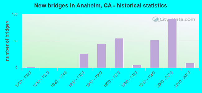
- New bridges - historical statistics
- 11920-1929
- 261950-1959
- 451960-1969
- 551970-1979
- 51980-1989
- 521990-1999
- 922000-2009
- 92010-2019
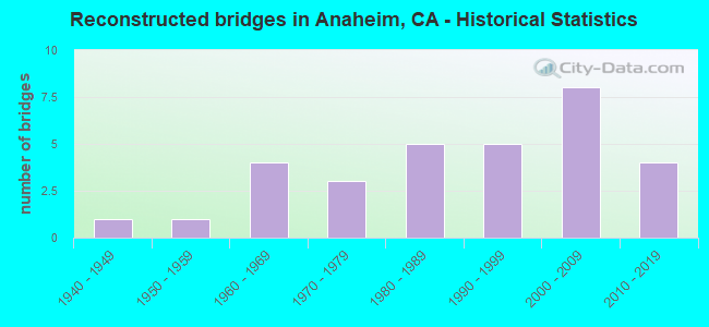
- Reconstructed bridges - Historical Statistics
- 11940-1949
- 11950-1959
- 41960-1969
- 31970-1979
- 51980-1989
- 51990-1999
- 82000-2009
- 42010-2019
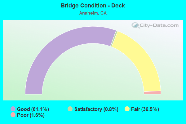
- Bridge Condition - Deck
- 61.1%Good
- 0.8%Satisfactory
- 36.5%Fair
- 1.6%Poor
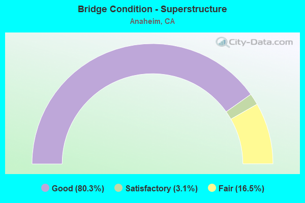
- Bridge Condition - Superstructure
- 80.3%Good
- 3.1%Satisfactory
- 16.5%Fair
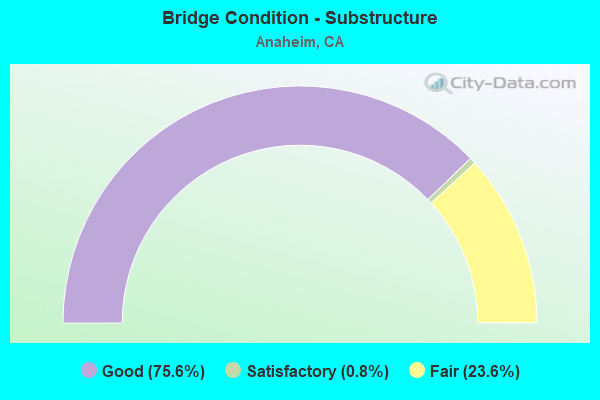
- Bridge Condition - Substructure
- 75.6%Good
- 0.8%Satisfactory
- 23.6%Fair
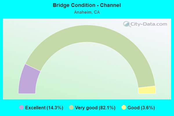
- Bridge Condition - Channel
- 14.3%Excellent
- 82.1%Very good
- 3.6%Good
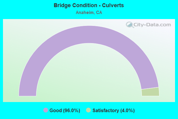
- Bridge Condition - Culverts
- 96.0%Good
- 4.0%Satisfactory
Find on map >> Show street view
Structure Number: 55 0858, Location: 12-ORA-091-3.51-ANA (Lat: 33.854433, Lng: -117.920061), Route carried "under" structure: State highway 91, Year Built: 1999, Structure Length: 0. m, Average Daily Traffic: 268,000 (year 2011), Truck Traffic: 8%, Features Intersected: STATE ROUTE 91, Facility Carried by Structure: LEMON STREET
Minimum Vertical Clearance: 5.48m (17.98ft), Kilometerpoint: 3.510, Lanes on structure: 7, Lanes under structure: 10, Material/Design: Prestressed concrete continuous, Design/Construction: Box Beam or Girders - Multiple, Length of Maximum Span: 26.0m (85.3ft)
Find on map >> Show street view
Structure Number: 55 0859, Location: 12-ORA-005-37.40-ANA (Lat: 33.814583, Lng: -117.915156), Route carried "under" structure: Interstate 5, Year Built: 2000, Structure Length: 0. m, Average Daily Traffic: 264,800 (year 2016), Truck Traffic: 7%, Features Intersected: INTERSTATE 5, Facility Carried by Structure: HARBOR BLVD
Minimum Vertical Clearance: 5.51m (18.08ft), Kilometerpoint: 37.400, Lanes on structure: 8, Lanes under structure: 13, Material/Design: Steel continuous, Design/Construction: Stringer/Multi-beam, Length of Maximum Span: 70.6m (231.6ft)
Find on map >> Show street view
Structure Number: 55 086, Location: 12-ORA-005-38.48-ANA (Lat: 33.827525, Lng: -117.927642), Route carried "under" structure: Interstate 5, Year Built: 2000, Structure Length: 0. m, Average Daily Traffic: 276,300 (year 2016), Truck Traffic: 7%, Features Intersected: INTERSTATE 5, Facility Carried by Structure: SANTA ANA STREET
Minimum Vertical Clearance: 6.07m (19.91ft), Kilometerpoint: 38.480, Lanes on structure: 3, Lanes under structure: 13, Material/Design: Prestressed concrete continuous, Design/Construction: Box Beam or Girders - Multiple, Length of Maximum Span: 41.7m (136.8ft)
Find on map >> Show street view
Structure Number: 55 0901, Location: 12-ORA-005-40.93-ANA (Lat: 33.846786, Lng: -117.963506), Route carried "under" structure: Interstate 5, Year Built: 2002, Structure Length: 0. m, Average Daily Traffic: 259,800 (year 2016), Truck Traffic: 9%, Features Intersected: INTERSTATE 5,RAMPS,UP RR, Facility Carried by Structure: LA PALMA AVE
Minimum Vertical Clearance: 6.78m (22.24ft), Kilometerpoint: 40.930, Lanes on structure: 6, Lanes under structure: 10, Material/Design: Prestressed concrete continuous, Design/Construction: Box Beam or Girders - Multiple, Length of Maximum Span: 99.4m (326.1ft)
Find on map >> Show street view
Structure Number: 55 0902S, Location: 12-ORA-005-40.55-ANA (Lat: 33.844442, Lng: -117.957914), Route carried "under" structure: Interstate 5, Year Built: 2002, Structure Length: 0. m, Average Daily Traffic: 259,800 (year 2016), Truck Traffic: 9%, Features Intersected: INTERSTATE 5, RAMP
Minimum Vertical Clearance: 6.19m (20.31ft), Kilometerpoint: 40.550, Lanes on structure: 2, Lanes under structure: 10, Material/Design: Concrete continuous, Design/Construction: Box Beam or Girders - Single/Spread, Length of Maximum Span: 80.0m (262.5ft)
Find on map >> Show street view
Structure Number: 55 0904, Location: 12-ORA-005-40.72-ANA (Lat: 33.845003, Lng: -117.958725), Route carried "under" structure: Interstate 5, Year Built: 2002, Structure Length: 0. m, Average Daily Traffic: 259,800 (year 2016), Truck Traffic: 9%, Features Intersected: INTERSTATE 5, RAMP, Facility Carried by Structure: BROOKHURST STREET
Minimum Vertical Clearance: 6.68m (21.92ft), Kilometerpoint: 40.720, Lanes on structure: 7, Lanes under structure: 11, Material/Design: Prestressed concrete continuous, Design/Construction: Box Beam or Girders - Multiple, Length of Maximum Span: 57.2m (187.7ft)
Find on map >> Show street view
Structure Number: 55 0941F, Location: 12-ORA-091-R15.90-ANA (Lat: 33.862811, Lng: -117.716636), Route carried "under" structure: Ramp State highway 241, Year Built: 1998, Structure Length: 0. m, Average Daily Traffic: 5,200 (year 2014), Truck Traffic: 5%, Features Intersected: N241-W91 CONNECTOR
Minimum Vertical Clearance: 5.30m (17.39ft), Kilometerpoint: 39.000, Lanes on structure: 3, Lanes under structure: 2, Material/Design: Prestressed concrete, Design/Construction: Box Beam or Girders - Multiple, Length of Maximum Span: 62.0m (203.4ft)
Find on map >> Show street view
Structure Number: 55 0960S, Location: 12-ORA-005-35.00-ANA (Lat: 33.790000, Lng: -117.887408), Route carried "under" structure: Ramp Interstate 5, Year Built: 2000, Structure Length: 0. m, Average Daily Traffic: 1,001 (year 2016), Truck Traffic: 3%, Features Intersected: CHAPMAN AVE-N5 ON-RAMP
Minimum Vertical Clearance: 6.02m (19.75ft), Kilometerpoint: 35.000, Lanes on structure: 2, Lanes under structure: 1, Material/Design: Prestressed concrete continuous, Design/Construction: Box Beam or Girders - Single/Spread, Length of Maximum Span: 61.0m (200.1ft)
Find on map >> Show street view
Structure Number: 55 1064, Location: 12-ORA-090-12.25 (Lat: 33.863033, Lng: -117.790650), Route carried "under" structure: City street , Year Built: 2010, Structure Length: 0. m, Average Daily Traffic: 30,000 (year 2011), Truck Traffic: 2%, Features Intersected: ESPERANZA RD,BNSF,AMTRAK, Facility Carried by Structure: STATE ROUTE 90
Minimum Vertical Clearance: 8.75m (28.71ft), Kilometerpoint: 0.000, Lanes on structure: 9, Lanes under structure: 8, Material/Design: Prestressed concrete continuous, Design/Construction: Box Beam or Girders - Multiple, Length of Maximum Span: 37.0m (121.4ft)
Find on map >> Show street view
Structure Number: 55 1081, Location: 12-ORA-022-R8.33-ANA (Lat: 33.770469, Lng: -117.913456), Route carried "under" structure: State highway 22, Year Built: 2008, Structure Length: 0. m, Average Daily Traffic: 229,000 (year 2009), Truck Traffic: 5%, Features Intersected: STATE ROUTE 22, Facility Carried by Structure: PEDESTRIAN WALKWAY
Minimum Vertical Clearance: 5.70m (18.70ft), Kilometerpoint: 8.330, Lanes under structure: 16, Material/Design: Concrete continuous, Design/Construction: Box Beam or Girders - Single/Spread, Length of Maximum Span: 31.7m (104.0ft)
Find on map >> Show street view
Structure Number: 55 1082, Location: 12-ORA-022-R9.40-ANA (Lat: 33.778825, Lng: -117.896661), Route carried "under" structure: State highway 22, Year Built: 2008, Structure Length: 0. m, Average Daily Traffic: 250,000 (year 2020), Truck Traffic: 3%, Features Intersected: STATE ROUTE 22, Facility Carried by Structure: LEWIS ST
Minimum Vertical Clearance: 5.28m (17.32ft), Kilometerpoint: 9.400, Lanes on structure: 4, Lanes under structure: 12, Material/Design: Prestressed concrete continuous, Design/Construction: Box Beam or Girders - Multiple, Length of Maximum Span: 33.3m (109.3ft)
Find on map >> Show street view
Structure Number: 55 1085G, Location: 12-ORA-022-R10.66-ANA (Lat: 33.778000, Lng: -117.873519), Route carried "under" structure: Ramp Interstate 5, Year Built: 2008, Structure Length: 0. m, Average Daily Traffic: 13,000 (year 2020), Truck Traffic: 3%, Features Intersected: N5-W22 CONNECTOR RAMP
Minimum Vertical Clearance: 6.14m (20.14ft), Kilometerpoint: 33.840, Lanes on structure: 2, Lanes under structure: 2, Material/Design: Prestressed concrete, Design/Construction: Box Beam or Girders - Multiple, Length of Maximum Span: 45.0m (147.6ft)
Find on map >> Show street view
Structure Number: 55 1087F, Location: 12-ORA-005-34.53-ANA (Lat: 33.779456, Lng: -117.889158), Route carried "under" structure: City street , Year Built: 2008, Structure Length: 0. m, Average Daily Traffic: 34,000 (year 2018), Truck Traffic: 2%, Features Intersected: THE CITY DRIVE, Facility Carried by Structure: S5&S57-W22 CONNECT
Minimum Vertical Clearance: 9.49m (31.14ft), Kilometerpoint: 0.000, Lanes on structure: 2, Lanes under structure: 7, Material/Design: Concrete, Design/Construction: Box Beam or Girders - Multiple, Length of Maximum Span: 55.8m (183.1ft)
Find on map >> Show street view
Structure Number: 55C007, Location: 0.2 MI E/O STATE COLLEGE (Lat: 33.804556, Lng: -117.885372), Route carried "under" structure: City street , Year Built: 1967, Structure Length: 0. m, Average Daily Traffic: 35,600 (year 2012), Truck Traffic: 4%, Features Intersected: KATELLA AVENUE, Facility Carried by Structure: BNSF RR, METROLINK
Minimum Vertical Clearance: 4.60m (15.09ft), Kilometerpoint: 0.000, Lanes under structure: 6, Material/Design: Concrete, Design/Construction: Box Beam or Girders - Multiple, Length of Maximum Span: 18.3m (60.0ft)
Find on map >> Show street view
Structure Number: 55C0471, Location: 0.4 MI. S/O BALL ROAD (Lat: 33.813289, Lng: -117.898250), Route carried "under" structure: City street , Year Built: 1972, Structure Length: 0. m, Average Daily Traffic: 6,500 (year 2008), Truck Traffic: 8%, Features Intersected: LEWIS STREET, Facility Carried by Structure: UP RR & METRO LINK
Minimum Vertical Clearance: 5.08m (16.67ft), Kilometerpoint: 0.000, Lanes under structure: 4, Material/Design: Prestressed concrete continuous, Design/Construction: Box Beam or Girders - Multiple, Length of Maximum Span: 28.7m (94.2ft)
Find on map >> Show street view
Structure Number: 55C0559, Location: 0.5 MI. E/O ANAHEIM BLVD (Lat: 33.837369, Lng: -117.906447), Route carried "under" structure: City street , Year Built: 1988, Structure Length: 0. m, Average Daily Traffic: 22,700 (year 2009), Truck Traffic: 5%, Features Intersected: LINCOLN AVENUE, Facility Carried by Structure: BNSF RR, METROLINK
Minimum Vertical Clearance: 4.72m (15.49ft), Kilometerpoint: 0.000, Lanes under structure: 6, Material/Design: Prestressed concrete, Design/Construction: Box Beam or Girders - Multiple, Length of Maximum Span: 17.7m (58.1ft)
Find on map >> Show street view
Structure Number: 55C0673, Location: AT BALL ROAD (Lat: 33.817167, Lng: -117.922056), Route carried "under" structure: City street , Year Built: 2000, Structure Length: 0. m, Average Daily Traffic: 44,200 (year 2019), Truck Traffic: 1%, Features Intersected: BALL ROAD, Facility Carried by Structure: DISNEYLAND FLYOVER
Minimum Vertical Clearance: 5.40m (17.72ft), Kilometerpoint: 0.000, Lanes on structure: 2, Lanes under structure: 10, Material/Design: Prestressed concrete continuous, Design/Construction: Box Beam or Girders - Multiple, Length of Maximum Span: 70.0m (229.7ft)
Find on map >> Show street view
Structure Number: 55C0676, Location: 0.5 MI N/O KATELLA AVENUE (Lat: 33.808950, Lng: -117.924217), Route carried "under" structure: City street , Year Built: 2000, Structure Length: 0. m, Average Daily Traffic: 10,000 (year 2020), Truck Traffic: 1%, Features Intersected: DISNEYLAND DRIVE, Facility Carried by Structure: DOWNTOWN DISNY POC
Minimum Vertical Clearance: 4.26m (13.98ft), Kilometerpoint: 0.000, Lanes under structure: 4, Material/Design: Steel, Design/Construction: Stringer/Multi-beam, Length of Maximum Span: 16.2m (53.1ft)
Find on map >> Show street view
Structure Number: 55C0692, Location: .17 MI E OF N MILTON ST (Lat: 33.843661, Lng: -117.876650), Route carried "under" structure: State highway 57, Year Built: 1974, Structure Length: 0. m, Average Daily Traffic: 229,000 (year 2009), Truck Traffic: 8%, Features Intersected: STATE ROUTE 57, Facility Carried by Structure: PEDESTRIAN WALKWAY
Minimum Vertical Clearance: 5.68m (18.64ft), Kilometerpoint: 15.180, Lanes under structure: 13, Material/Design: Concrete continuous, Design/Construction: Box Beam or Girders - Multiple, Length of Maximum Span: 35.1m (115.2ft)
Find on map >> Show street view
Structure Number: 55C0707, Location: 0.1 MILE N/O CROWTHER AVE (Lat: 33.868544, Lng: -117.863319), Route carried "under" structure: Business City street , Year Built: 2014, Structure Length: 0. m, Average Daily Traffic: 21,000 (year 2017), Truck Traffic: 2%, Features Intersected: KRAEMER BLVD, Facility Carried by Structure: BNSF RR TRACKS
Minimum Vertical Clearance: 5.10m (16.73ft), Kilometerpoint: 0.000, Lanes under structure: 7, Material/Design: Steel, Design/Construction: Stringer/Multi-beam, Length of Maximum Span: 20.6m (67.6ft)
Find on map >> Show street view
Structure Number: 55C0715, Location: 1 M N/O ROUTE 91 (Lat: 33.866269, Lng: -117.818356), Route carried "under" structure: City street , Year Built: 2017, Structure Length: 0. m, Average Daily Traffic: 8,900 (year 2018), Truck Traffic: 2%, Features Intersected: RR AND ORANGTHROPE AVE, Facility Carried by Structure: LAKEVIEW AVE
Minimum Vertical Clearance: 6.70m (21.98ft), Kilometerpoint: 0.000, Lanes on structure: 4, Lanes under structure: 5, Material/Design: Prestressed concrete, Design/Construction: Stringer/Multi-beam, Length of Maximum Span: 41.1m (134.8ft)