Bridge Statistics for Philadelphia, Pennsylvania (PA)
Condition, Traffic, Stress, Structural Evaluation, Project Costs
- National Bridge Inventory (NBI) Statistics
- 1,227Number of bridges
- 25,561ft / 7,791mTotal length
- $1,156,795,000Total costs
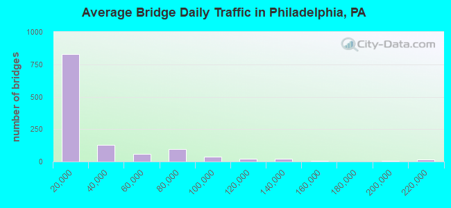
- 32,975,097Total average daily traffic
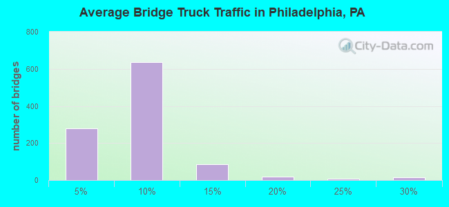
- 2,105,575Total average daily truck traffic
- National Bridge Inventory (NBI) Registered Bridges for Philadelphia
- No street view available for this location
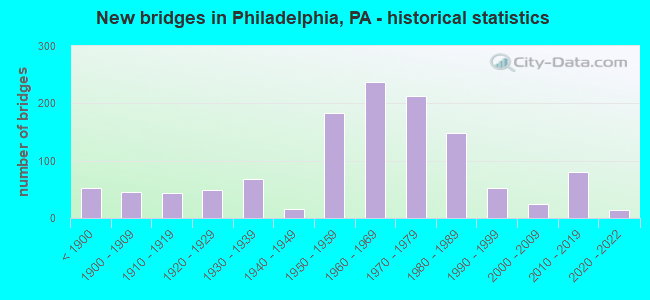
- New bridges - historical statistics
- 53Before 1900
- 451900-1909
- 431910-1919
- 481920-1929
- 681930-1939
- 151940-1949
- 1831950-1959
- 2381960-1969
- 2131970-1979
- 1491980-1989
- 531990-1999
- 252000-2009
- 802010-2019
- 142020-2022
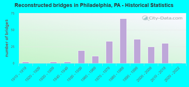
- Reconstructed bridges - Historical Statistics
- 21910-1919
- 01920-1929
- 21930-1939
- 21940-1949
- 191950-1959
- 111960-1969
- 331970-1979
- 671980-1989
- 361990-1999
- 252000-2009
- 302010-2019
- 12020-2022
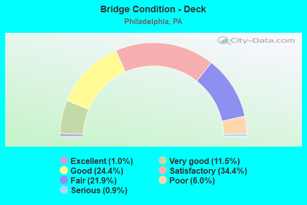
- Bridge Condition - Deck
- 1.0%Excellent
- 11.5%Very good
- 24.4%Good
- 34.4%Satisfactory
- 21.9%Fair
- 6.0%Poor
- 0.9%Serious
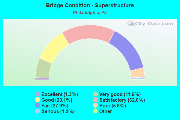
- Bridge Condition - Superstructure
- 1.5%Excellent
- 11.3%Very good
- 18.7%Good
- 32.9%Satisfactory
- 26.6%Fair
- 7.5%Poor
- 1.2%Serious
- 0.3%Imminent failure
- 0.2%Failed
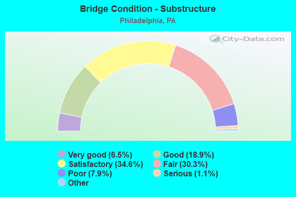
- Bridge Condition - Substructure
- 6.5%Excellent
- 18.9%Very good
- 34.6%Good
- 30.3%Satisfactory
- 7.9%Fair
- 1.1%Poor
- 0.8%Serious
- 0.2%Critical
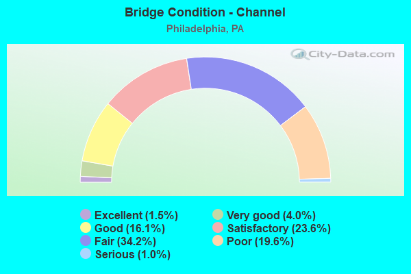
- Bridge Condition - Channel
- 1.5%Excellent
- 4.0%Very good
- 16.1%Good
- 23.6%Satisfactory
- 34.2%Fair
- 19.6%Poor
- 1.0%Serious
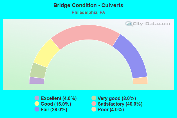
- Bridge Condition - Culverts
- 3.3%Excellent
- 6.7%Very good
- 20.0%Good
- 43.3%Satisfactory
- 23.3%Fair
- 3.3%Poor
Find on map >> Show street view
Structure Number: 38516, Location: N.PLATT BRIDGE 3699 D08 (Lat: 39.892667, Lng: -75.226708), Route carried "under" structure: State highway 291, Year Built: 1984, Structure Length: 0. m, Average Daily Traffic: 34,695 (year 2022), Truck Traffic: 3%, Features Intersected: PENROSE AVE.& TRIB MINGO, Facility Carried by Structure: INTERSTATE 95 N.B.
Minimum Vertical Clearance: 4.93m (16.17ft), Kilometerpoint: 4.389, Lanes on structure: 3, Lanes under structure: 2, Material/Design: Steel continuous, Design/Construction: Stringer/Multi-beam, Length of Maximum Span: 73.2m (240.2ft)
Find on map >> Show street view
Structure Number: 38516, Location: N.PLATT BRIDGE 3699 D08 (Lat: 39.892667, Lng: -75.226708), Route carried "under" structure: State highway 291, Year Built: 1984, Structure Length: 0. m, Average Daily Traffic: 38,853 (year 2022), Truck Traffic: 4%, Features Intersected: PENROSE AVE.& TRIB MINGO, Facility Carried by Structure: INTERSTATE 95 N.B.
Minimum Vertical Clearance: 4.82m (15.81ft), Kilometerpoint: 4.353, Lanes on structure: 3, Lanes under structure: 2, Material/Design: Steel continuous, Design/Construction: Stringer/Multi-beam, Length of Maximum Span: 73.2m (240.2ft)
Find on map >> Show street view
Structure Number: 38516, Location: N.PLATT BRIDGE 3699 D08 (Lat: 39.892667, Lng: -75.226708), Route carried "under" structure: Ramp State highway , Year Built: 1984, Structure Length: 0. m, Average Daily Traffic: 10,773 (year 2021), Truck Traffic: 10%, Features Intersected: PENROSE AVE.& TRIB MINGO, Facility Carried by Structure: INTERSTATE 95 N.B.
Minimum Vertical Clearance: 4.65m (15.26ft), Kilometerpoint: 0.000, Lanes on structure: 3, Lanes under structure: 1, Material/Design: Steel continuous, Design/Construction: Stringer/Multi-beam, Length of Maximum Span: 73.2m (240.2ft)
Find on map >> Show street view
Structure Number: 38516, Location: N.PLATT BRIDGE 3699 D08 (Lat: 39.892667, Lng: -75.226708), Route carried "under" structure: Business City street , Year Built: 1984, Structure Length: 0. m, Average Daily Traffic: 4,500 (year 2006), Truck Traffic: 2%, Features Intersected: PENROSE AVE.& TRIB MINGO, Facility Carried by Structure: INTERSTATE 95 N.B.
Minimum Vertical Clearance: 9.07m (29.76ft), Kilometerpoint: 0.000, Lanes on structure: 3, Lanes under structure: 2, Material/Design: Steel continuous, Design/Construction: Stringer/Multi-beam, Length of Maximum Span: 73.2m (240.2ft)
Find on map >> Show street view
Structure Number: 38517, Location: N.PLATT BRIDGE 3699E08 (Lat: 39.892217, Lng: -75.223906), Route carried "under" structure: State highway 291, Year Built: 1984, Structure Length: 0. m, Average Daily Traffic: 38,853 (year 2022), Truck Traffic: 4%, Features Intersected: PENROSE AVE/TRIB MINGO C, Facility Carried by Structure: INTERSTATE 95 S.B.
Minimum Vertical Clearance: 4.52m (14.83ft), Kilometerpoint: 4.353, Lanes on structure: 4, Lanes under structure: 2, Material/Design: Steel continuous, Design/Construction: Stringer/Multi-beam, Length of Maximum Span: 71.3m (233.9ft)
Find on map >> Show street view
Structure Number: 38517, Location: N.PLATT BRIDGE 3699E08 (Lat: 39.892217, Lng: -75.223906), Route carried "under" structure: State highway 291, Year Built: 1984, Structure Length: 0. m, Average Daily Traffic: 34,695 (year 2022), Truck Traffic: 3%, Features Intersected: PENROSE AVE/TRIB MINGO C, Facility Carried by Structure: INTERSTATE 95 S.B.
Minimum Vertical Clearance: 4.62m (15.16ft), Kilometerpoint: 4.389, Lanes on structure: 4, Lanes under structure: 2, Material/Design: Steel continuous, Design/Construction: Stringer/Multi-beam, Length of Maximum Span: 71.3m (233.9ft)
Find on map >> Show street view
Structure Number: 38517, Location: N.PLATT BRIDGE 3699E08 (Lat: 39.892217, Lng: -75.223906), Route carried "under" structure: Business City street , Year Built: 1984, Structure Length: 0. m, Average Daily Traffic: 5,600 (year 1980), Truck Traffic: 3%, Features Intersected: PENROSE AVE/TRIB MINGO C, Facility Carried by Structure: INTERSTATE 95 S.B.
Minimum Vertical Clearance: 7.62m (25.00ft), Kilometerpoint: 0.000, Lanes on structure: 4, Lanes under structure: 2, Material/Design: Steel continuous, Design/Construction: Stringer/Multi-beam, Length of Maximum Span: 71.3m (233.9ft)
Find on map >> Show street view
Structure Number: 38517, Location: N.PLATT BRIDGE 3699E08 (Lat: 39.892217, Lng: -75.223906), Route carried "under" structure: Ramp State highway , Year Built: 1984, Structure Length: 0. m, Average Daily Traffic: 10,773 (year 2021), Truck Traffic: 10%, Features Intersected: PENROSE AVE/TRIB MINGO C, Facility Carried by Structure: INTERSTATE 95 S.B.
Minimum Vertical Clearance: 6.55m (21.49ft), Kilometerpoint: 0.000, Lanes on structure: 4, Lanes under structure: 1, Material/Design: Steel continuous, Design/Construction: Stringer/Multi-beam, Length of Maximum Span: 71.3m (233.9ft)
Find on map >> Show street view
Structure Number: 38518, Location: N.PLATT BRIDGE 3699F09 (Lat: 39.890611, Lng: -75.221517), Route carried "under" structure: Ramp State highway , Year Built: 1985, Structure Length: 0. m, Average Daily Traffic: 2,563 (year 2021), Truck Traffic: 9%, Features Intersected: SLUDGE LAGOONS & RAMP B, Facility Carried by Structure: INTERSTATE 95 N.B.
Minimum Vertical Clearance: 5.03m (16.50ft), Kilometerpoint: 0.000, Lanes on structure: 3, Lanes under structure: 1, Material/Design: Prestressed concrete continuous, Design/Construction: Stringer/Multi-beam, Length of Maximum Span: 29.0m (95.1ft)
Find on map >> Show street view
Structure Number: 3852, Location: N.PLATT BRIDGE 3699F08 (Lat: 39.891167, Lng: -75.221589), Route carried "under" structure: Ramp State highway , Year Built: 1985, Structure Length: 0. m, Average Daily Traffic: 2,563 (year 2021), Truck Traffic: 9%, Features Intersected: SLUDGE LAGOONS & RAMP B, Facility Carried by Structure: INTERSTATE 95 S.B.
Minimum Vertical Clearance: 4.62m (15.16ft), Kilometerpoint: 0.000, Lanes on structure: 3, Lanes under structure: 1, Material/Design: Prestressed concrete continuous, Design/Construction: Stringer/Multi-beam, Length of Maximum Span: 29.0m (95.1ft)
Find on map >> Show street view
Structure Number: 38523, Location: ENTERPRISE AVE.RP.3699G09 (Lat: 39.886389, Lng: -75.214439), Route carried "under" structure: ServiceOther road , Year Built: 1971, Structure Length: 0. m, Average Daily Traffic: 700 (year 1980), Truck Traffic: 15%, Features Intersected: RR;ACCESS RD;HOG ISLAND, Facility Carried by Structure: INTERSTATE 95 N.B.
Minimum Vertical Clearance: 8.76m (28.74ft), Kilometerpoint: 0.000, Lanes on structure: 3, Lanes under structure: 2, Material/Design: Steel continuous, Design/Construction: Stringer/Multi-beam, Length of Maximum Span: 37.2m (122.0ft)
Find on map >> Show street view
Structure Number: 38523, Location: ENTERPRISE AVE.RP.3699G09 (Lat: 39.886389, Lng: -75.214439), Route carried "under" structure: Business City street , Year Built: 1971, Structure Length: 0. m, Average Daily Traffic: 1 (year 2006), Truck Traffic: 1%, Features Intersected: RR;ACCESS RD;HOG ISLAND, Facility Carried by Structure: INTERSTATE 95 N.B.
Minimum Vertical Clearance: 10.67m (35.01ft), Kilometerpoint: 0.000, Lanes on structure: 3, Lanes under structure: 4, Material/Design: Steel continuous, Design/Construction: Stringer/Multi-beam, Length of Maximum Span: 37.2m (122.0ft)
Find on map >> Show street view
Structure Number: 38529, Location: S.APPR.GIRARD PT. 3699G09 (Lat: 39.886083, Lng: -75.210889), Route carried "under" structure: Interstate 95, Year Built: 1973, Structure Length: 0. m, Average Daily Traffic: 69,076 (year 2022), Truck Traffic: 6%, Features Intersected: SWAMP LAND (SLUDGE)
Minimum Vertical Clearance: 5.46m (17.91ft), Kilometerpoint: 4.743, Lanes on structure: 3, Lanes under structure: 3, Material/Design: Steel continuous, Design/Construction: Stringer/Multi-beam, Length of Maximum Span: 28.3m (92.8ft)
Find on map >> Show street view
Structure Number: 3853, Location: GIRARD POINT BRD. 3699J08 (Lat: 39.887889, Lng: -75.203631), Route carried "under" structure: Federal lands road , Year Built: 1973, Structure Length: 0. m, Average Daily Traffic: 150 (year 1980), Truck Traffic: 7%, Features Intersected: SCHUYLKILL RIVER,RR,ROAD, Facility Carried by Structure: I-95'DOUBLE DECKER
Minimum Vertical Clearance: 21.34m (70.01ft), Kilometerpoint: 0.000, Lanes on structure: 3, Lanes under structure: 4, Material/Design: Steel continuous, Design/Construction: Truss - Thru, Length of Maximum Span: 213.4m (700.1ft)
Find on map >> Show street view
Structure Number: 38535, Location: S.APPR.GIRARD PT.3700A07 (Lat: 39.897000, Lng: -75.189589), Route carried "under" structure: Interstate 95, Year Built: 1973, Structure Length: 0. m, Average Daily Traffic: 69,076 (year 2022), Truck Traffic: 6%, Features Intersected: ROOSELT.PK.NAVY YARD;I95
Minimum Vertical Clearance: 5.33m (17.49ft), Kilometerpoint: 7.347, Lanes on structure: 3, Lanes under structure: 3, Material/Design: Steel continuous, Design/Construction: Stringer/Multi-beam, Length of Maximum Span: 38.1m (125.0ft)
Find on map >> Show street view
Structure Number: 38537, Location: BETW.JFK & NAVY YD3700B07 (Lat: 39.898139, Lng: -75.182811), Route carried "under" structure: State highway 611, Year Built: 1973, Structure Length: 0. m, Average Daily Traffic: 9,133 (year 2021), Truck Traffic: 7%, Features Intersected: BROAD ST.NB&SBI-95RAMP A, Facility Carried by Structure: INTERSTATE 95
Minimum Vertical Clearance: 5.23m (17.16ft), Kilometerpoint: 0.000, Lanes on structure: 3, Lanes under structure: 3, Material/Design: Steel continuous, Design/Construction: Stringer/Multi-beam, Length of Maximum Span: 42.7m (140.1ft)
Find on map >> Show street view
Structure Number: 38537, Location: BETW.JFK & NAVY YD3700B07 (Lat: 39.898139, Lng: -75.182811), Route carried "under" structure: Ramp State highway , Year Built: 1973, Structure Length: 0. m, Average Daily Traffic: 6,887 (year 2021), Truck Traffic: 7%, Features Intersected: BROAD ST.NB&SBI-95RAMP A, Facility Carried by Structure: INTERSTATE 95
Minimum Vertical Clearance: 5.13m (16.83ft), Kilometerpoint: 0.000, Lanes on structure: 3, Lanes under structure: 1, Material/Design: Steel continuous, Design/Construction: Stringer/Multi-beam, Length of Maximum Span: 42.7m (140.1ft)
Find on map >> Show street view
Structure Number: 38537, Location: BETW.JFK & NAVY YD3700B07 (Lat: 39.898139, Lng: -75.182811), Route carried "under" structure: State highway , Year Built: 1973, Structure Length: 0. m, Average Daily Traffic: 3,000 (year 2004), Truck Traffic: 5%, Features Intersected: BROAD ST.NB&SBI-95RAMP A, Facility Carried by Structure: INTERSTATE 95
Minimum Vertical Clearance: 5.21m (17.09ft), Kilometerpoint: 0.000, Lanes on structure: 3, Lanes under structure: 2, Material/Design: Steel continuous, Design/Construction: Stringer/Multi-beam, Length of Maximum Span: 42.7m (140.1ft)
Find on map >> Show street view
Structure Number: 38537, Location: BETW.JFK & NAVY YD3700B07 (Lat: 39.898139, Lng: -75.182811), Route carried "under" structure: State highway 611, Year Built: 1973, Structure Length: 0. m, Average Daily Traffic: 11,027 (year 2021), Truck Traffic: 9%, Features Intersected: BROAD ST.NB&SBI-95RAMP A, Facility Carried by Structure: INTERSTATE 95
Minimum Vertical Clearance: 5.24m (17.19ft), Kilometerpoint: 0.000, Lanes on structure: 3, Lanes under structure: 3, Material/Design: Steel continuous, Design/Construction: Stringer/Multi-beam, Length of Maximum Span: 42.7m (140.1ft)
Find on map >> Show street view
Structure Number: 38541, Location: EAST BROAD STREET 3700C07 (Lat: 39.898722, Lng: -75.172614), Route carried "under" structure: State highway , Year Built: 1972, Structure Length: 0. m, Average Daily Traffic: 800 (year 2006), Truck Traffic: 2%, Features Intersected: TERMINAL AVE;RR SIDINGS;, Facility Carried by Structure: DELAWARE EXPWAY.
Minimum Vertical Clearance: 6.53m (21.42ft), Kilometerpoint: 0.000, Lanes on structure: 3, Lanes under structure: 2, Material/Design: Steel continuous, Design/Construction: Stringer/Multi-beam, Length of Maximum Span: 39.6m (129.9ft)
Find on map >> Show street view
Structure Number: 38541, Location: EAST BROAD STREET 3700C07 (Lat: 39.898722, Lng: -75.172614), Route carried "under" structure: State highway , Year Built: 1972, Structure Length: 0. m, Average Daily Traffic: 3,400 (year 1980), Truck Traffic: 8%, Features Intersected: TERMINAL AVE;RR SIDINGS;, Facility Carried by Structure: DELAWARE EXPWAY.
Minimum Vertical Clearance: 5.06m (16.60ft), Kilometerpoint: 0.000, Lanes on structure: 3, Lanes under structure: 2, Material/Design: Steel continuous, Design/Construction: Stringer/Multi-beam, Length of Maximum Span: 39.6m (129.9ft)
Find on map >> Show street view
Structure Number: 38547, Location: PACKER BAR 3700F06 (Lat: 39.902056, Lng: -75.151189), Route carried "under" structure: State highway , Year Built: 1974, Structure Length: 0. m, Average Daily Traffic: 8,900 (year 1980), Truck Traffic: 7%, Features Intersected: PATTISON AVENUE, Facility Carried by Structure: INTERSTATE 95
Minimum Vertical Clearance: 4.45m (14.60ft), Kilometerpoint: 0.000, Lanes on structure: 3, Lanes under structure: 5, Material/Design: Steel continuous, Design/Construction: Stringer/Multi-beam, Length of Maximum Span: 41.1m (134.8ft)
Find on map >> Show street view
Structure Number: 38549, Location: SOUTH PHLY 3700 G04 (Lat: 39.914142, Lng: -75.148014), Route carried "under" structure: City street , Year Built: 1974, Structure Length: 0. m, Average Daily Traffic: 8,900 (year 1980), Truck Traffic: 7%, Features Intersected: OREGON AVE & SHUNK ST, Facility Carried by Structure: INTERSTATE 95
Minimum Vertical Clearance: 7.42m (24.34ft), Kilometerpoint: 0.000, Lanes on structure: 3, Lanes under structure: 2, Material/Design: Prestressed concrete continuous, Design/Construction: Stringer/Multi-beam, Length of Maximum Span: 20.1m (65.9ft)
Find on map >> Show street view
Structure Number: 38549, Location: SOUTH PHLY 3700 G04 (Lat: 39.914142, Lng: -75.148014), Route carried "under" structure: State highway , Year Built: 1974, Structure Length: 0. m, Average Daily Traffic: 6,936 (year 2021), Truck Traffic: 15%, Features Intersected: OREGON AVE & SHUNK ST, Facility Carried by Structure: INTERSTATE 95
Minimum Vertical Clearance: 6.15m (20.18ft), Kilometerpoint: 1.619, Lanes on structure: 3, Lanes under structure: 2, Material/Design: Prestressed concrete continuous, Design/Construction: Stringer/Multi-beam, Length of Maximum Span: 20.1m (65.9ft)
Find on map >> Show street view
Structure Number: 38549, Location: SOUTH PHLY 3700 G04 (Lat: 39.914142, Lng: -75.148014), Route carried "under" structure: State highway , Year Built: 1974, Structure Length: 0. m, Average Daily Traffic: 6,580 (year 2021), Truck Traffic: 17%, Features Intersected: OREGON AVE & SHUNK ST, Facility Carried by Structure: INTERSTATE 95
Minimum Vertical Clearance: 6.07m (19.91ft), Kilometerpoint: 1.630, Lanes on structure: 3, Lanes under structure: 2, Material/Design: Prestressed concrete continuous, Design/Construction: Stringer/Multi-beam, Length of Maximum Span: 20.1m (65.9ft)
Find on map >> Show street view
Structure Number: 38552, Location: S.PHILA 3700G04 (Lat: 39.915556, Lng: -75.147525), Route carried "under" structure: State highway , Year Built: 1967, Structure Length: 0. m, Average Daily Traffic: 8,660 (year 2021), Truck Traffic: 4%, Features Intersected: SHUNK ST.TO MIFFLIN ST., Facility Carried by Structure: INTERSTATE 95
Minimum Vertical Clearance: 5.61m (18.41ft), Kilometerpoint: 3.899, Lanes on structure: 3, Lanes under structure: 2, Material/Design: Prestressed concrete continuous, Design/Construction: Stringer/Multi-beam, Length of Maximum Span: 24.1m (79.1ft)
Find on map >> Show street view
Structure Number: 38552, Location: S.PHILA 3700G04 (Lat: 39.915556, Lng: -75.147525), Route carried "under" structure: City street , Year Built: 1967, Structure Length: 0. m, Average Daily Traffic: 998 (year 1980), Truck Traffic: 7%, Features Intersected: SHUNK ST.TO MIFFLIN ST., Facility Carried by Structure: INTERSTATE 95
Minimum Vertical Clearance: 6.04m (19.82ft), Kilometerpoint: 0.000, Lanes on structure: 3, Lanes under structure: 1, Material/Design: Prestressed concrete continuous, Design/Construction: Stringer/Multi-beam, Length of Maximum Span: 24.1m (79.1ft)
Find on map >> Show street view
Structure Number: 38552, Location: S.PHILA 3700G04 (Lat: 39.915556, Lng: -75.147525), Route carried "under" structure: City street , Year Built: 1967, Structure Length: 0. m, Average Daily Traffic: 900 (year 1980), Truck Traffic: 7%, Features Intersected: SHUNK ST.TO MIFFLIN ST., Facility Carried by Structure: INTERSTATE 95
Minimum Vertical Clearance: 6.78m (22.24ft), Kilometerpoint: 0.000, Lanes on structure: 3, Lanes under structure: 1, Material/Design: Prestressed concrete continuous, Design/Construction: Stringer/Multi-beam, Length of Maximum Span: 24.1m (79.1ft)
Find on map >> Show street view
Structure Number: 38552, Location: S.PHILA 3700G04 (Lat: 39.915556, Lng: -75.147525), Route carried "under" structure: City street , Year Built: 1967, Structure Length: 0. m, Average Daily Traffic: 875 (year 1980), Truck Traffic: 7%, Features Intersected: SHUNK ST.TO MIFFLIN ST., Facility Carried by Structure: INTERSTATE 95
Minimum Vertical Clearance: 5.56m (18.24ft), Kilometerpoint: 0.000, Lanes on structure: 3, Lanes under structure: 1, Material/Design: Prestressed concrete continuous, Design/Construction: Stringer/Multi-beam, Length of Maximum Span: 24.1m (79.1ft)
Find on map >> Show street view
Structure Number: 38555, Location: QUEEN VILLAGE 3700-G02 (Lat: 39.923639, Lng: -75.147208), Route carried "under" structure: Ramp State highway , Year Built: 1979, Structure Length: 0. m, Average Daily Traffic: 6,651 (year 2021), Truck Traffic: 4%, Features Intersected: MIFFLIN ST TO CHRISTIAN, Facility Carried by Structure: DELAWARE EXPWAY.
Minimum Vertical Clearance: 5.72m (18.77ft), Kilometerpoint: 0.000, Lanes on structure: 4, Lanes under structure: 1, Material/Design: Prestressed concrete continuous, Design/Construction: Stringer/Multi-beam, Length of Maximum Span: 28.3m (92.8ft)
Find on map >> Show street view
Structure Number: 38555, Location: QUEEN VILLAGE 3700-G02 (Lat: 39.923639, Lng: -75.147208), Route carried "under" structure: State highway , Year Built: 1979, Structure Length: 0. m, Average Daily Traffic: 16,500 (year 1980), Truck Traffic: 10%, Features Intersected: MIFFLIN ST TO CHRISTIAN, Facility Carried by Structure: DELAWARE EXPWAY.
Minimum Vertical Clearance: 5.16m (16.93ft), Kilometerpoint: 0.000, Lanes on structure: 4, Lanes under structure: 2, Material/Design: Prestressed concrete continuous, Design/Construction: Stringer/Multi-beam, Length of Maximum Span: 28.3m (92.8ft)
Find on map >> Show street view
Structure Number: 38555, Location: QUEEN VILLAGE 3700-G02 (Lat: 39.923639, Lng: -75.147208), Route carried "under" structure: State highway , Year Built: 1979, Structure Length: 0. m, Average Daily Traffic: 16,500 (year 1980), Truck Traffic: 10%, Features Intersected: MIFFLIN ST TO CHRISTIAN, Facility Carried by Structure: DELAWARE EXPWAY.
Minimum Vertical Clearance: 6.17m (20.24ft), Kilometerpoint: 0.000, Lanes on structure: 4, Lanes under structure: 2, Material/Design: Prestressed concrete continuous, Design/Construction: Stringer/Multi-beam, Length of Maximum Span: 28.3m (92.8ft)
Find on map >> Show street view
Structure Number: 3856, Location: NEAR PENN'S LAND.3700G01 (Lat: 39.936011, Lng: -75.144467), Route carried "under" structure: State highway , Year Built: 1971, Structure Length: 0. m, Average Daily Traffic: 5,600 (year 1980), Truck Traffic: 10%, Features Intersected: QUEEN STREET, Facility Carried by Structure: INTERSTATE 95
Minimum Vertical Clearance: 4.54m (14.90ft), Kilometerpoint: 0.000, Lanes on structure: 4, Lanes under structure: 2, Material/Design: Prestressed concrete, Design/Construction: Stringer/Multi-beam, Length of Maximum Span: 15.8m (51.8ft)
Find on map >> Show street view
Structure Number: 38563, Location: .3MI.S.WALNUT STR.3590G10 (Lat: 39.938758, Lng: -75.143436), Route carried "under" structure: Ramp State highway , Year Built: 1990, Structure Length: 0. m, Average Daily Traffic: 14,087 (year 2021), Truck Traffic: 3%, Features Intersected: RAMPS SD AND DN, Facility Carried by Structure: INTERSTATE 95 (NB)
Minimum Vertical Clearance: 5.33m (17.49ft), Kilometerpoint: 0.000, Lanes on structure: 3, Lanes under structure: 2, Material/Design: Steel continuous, Design/Construction: Stringer/Multi-beam, Length of Maximum Span: 41.1m (134.8ft)
Find on map >> Show street view
Structure Number: 38563, Location: .3MI.S.WALNUT STR.3590G10 (Lat: 39.938758, Lng: -75.143436), Route carried "under" structure: Ramp State highway , Year Built: 1990, Structure Length: 0. m, Average Daily Traffic: 8,825 (year 2021), Truck Traffic: 4%, Features Intersected: RAMPS SD AND DN, Facility Carried by Structure: INTERSTATE 95 (NB)
Minimum Vertical Clearance: 5.41m (17.75ft), Kilometerpoint: 0.000, Lanes on structure: 3, Lanes under structure: 2, Material/Design: Steel continuous, Design/Construction: Stringer/Multi-beam, Length of Maximum Span: 41.1m (134.8ft)
Find on map >> Show street view
Structure Number: 38564, Location: PENN'S LANDING TUN.3590H9 (Lat: 39.944228, Lng: -75.142744), Route carried "under" structure: Interstate 95, Year Built: 1976, Structure Length: 0. m, Average Daily Traffic: 66,701 (year 2022), Truck Traffic: 8%, Features Intersected: I-95; RAMP NX; RAMP XN, Facility Carried by Structure: SPRUCE & DOCK STR.
Minimum Vertical Clearance: 5.24m (17.19ft), Kilometerpoint: 15.128, Lanes on structure: 2, Lanes under structure: 3, Material/Design: Prestressed concrete, Design/Construction: Box Beam or Girders - Multiple, Length of Maximum Span: 21.9m (71.9ft)
Find on map >> Show street view
Structure Number: 38564, Location: PENN'S LANDING TUN.3590H9 (Lat: 39.944228, Lng: -75.142744), Route carried "under" structure: Interstate 95, Year Built: 1976, Structure Length: 0. m, Average Daily Traffic: 56,770 (year 2022), Truck Traffic: 6%, Features Intersected: I-95; RAMP NX; RAMP XN, Facility Carried by Structure: SPRUCE & DOCK STR.
Minimum Vertical Clearance: 5.21m (17.09ft), Kilometerpoint: 15.062, Lanes on structure: 2, Lanes under structure: 3, Material/Design: Prestressed concrete, Design/Construction: Box Beam or Girders - Multiple, Length of Maximum Span: 21.9m (71.9ft)
Find on map >> Show street view
Structure Number: 38564, Location: PENN'S LANDING TUN.3590H9 (Lat: 39.944228, Lng: -75.142744), Route carried "under" structure: Ramp State highway , Year Built: 1976, Structure Length: 0. m, Average Daily Traffic: 5,395 (year 2021), Truck Traffic: 4%, Features Intersected: I-95; RAMP NX; RAMP XN, Facility Carried by Structure: SPRUCE & DOCK STR.
Minimum Vertical Clearance: 4.88m (16.01ft), Kilometerpoint: 0.000, Lanes on structure: 2, Lanes under structure: 1, Material/Design: Prestressed concrete, Design/Construction: Box Beam or Girders - Multiple, Length of Maximum Span: 21.9m (71.9ft)
Find on map >> Show street view
Structure Number: 38564, Location: PENN'S LANDING TUN.3590H9 (Lat: 39.944228, Lng: -75.142744), Route carried "under" structure: Ramp State highway , Year Built: 1976, Structure Length: 0. m, Average Daily Traffic: 3,553 (year 2021), Truck Traffic: 4%, Features Intersected: I-95; RAMP NX; RAMP XN, Facility Carried by Structure: SPRUCE & DOCK STR.
Minimum Vertical Clearance: 4.88m (16.01ft), Kilometerpoint: 0.000, Lanes on structure: 2, Lanes under structure: 1, Material/Design: Prestressed concrete, Design/Construction: Box Beam or Girders - Multiple, Length of Maximum Span: 21.9m (71.9ft)
Find on map >> Show street view
Structure Number: 38568, Location: NR.B FRANKLIN BRG.3590H08 (Lat: 39.953600, Lng: -75.140936), Route carried "under" structure: Business City street , Year Built: 1975, Structure Length: 0. m, Features Intersected: RACE STREET&RAMP NFN, Facility Carried by Structure: INTERSTATE 95 N.B.
Minimum Vertical Clearance: 4.55m (14.93ft), Kilometerpoint: 0.000, Lanes on structure: 3, Lanes under structure: 2, Material/Design: Steel continuous, Design/Construction: Stringer/Multi-beam, Length of Maximum Span: 18.6m (61.0ft)
Find on map >> Show street view
Structure Number: 38568, Location: NR.B FRANKLIN BRG.3590H08 (Lat: 39.953600, Lng: -75.140936), Route carried "under" structure: Ramp State highway , Year Built: 1975, Structure Length: 0. m, Average Daily Traffic: 6,285 (year 2021), Truck Traffic: 7%, Features Intersected: RACE STREET&RAMP NFN, Facility Carried by Structure: INTERSTATE 95 N.B.
Minimum Vertical Clearance: 4.44m (14.57ft), Kilometerpoint: 0.000, Lanes on structure: 3, Lanes under structure: 1, Material/Design: Steel continuous, Design/Construction: Stringer/Multi-beam, Length of Maximum Span: 18.6m (61.0ft)
Find on map >> Show street view
Structure Number: 38568, Location: NR.B FRANKLIN BRG.3590H08 (Lat: 39.953600, Lng: -75.140936), Route carried "under" structure: ServiceOther road , Year Built: 1975, Structure Length: 0. m, Average Daily Traffic: 90 (year 1980), Features Intersected: RACE STREET&RAMP NFN, Facility Carried by Structure: INTERSTATE 95 N.B.
Minimum Vertical Clearance: 4.44m (14.57ft), Kilometerpoint: 0.000, Lanes on structure: 3, Lanes under structure: 2, Material/Design: Steel continuous, Design/Construction: Stringer/Multi-beam, Length of Maximum Span: 18.6m (61.0ft)
Find on map >> Show street view
Structure Number: 3857, Location: NEAR RACE STREET 3590H07 (Lat: 39.956650, Lng: -75.140750), Route carried "under" structure: City street , Year Built: 1973, Structure Length: 0. m, Average Daily Traffic: 9,800 (year 1980), Truck Traffic: 7%, Features Intersected: CALLOWHILL STREET, Facility Carried by Structure: INTERSTATE 95 N.B.
Minimum Vertical Clearance: 4.44m (14.57ft), Kilometerpoint: 0.000, Lanes on structure: 4, Lanes under structure: 2, Material/Design: Steel, Design/Construction: Stringer/Multi-beam, Length of Maximum Span: 20.1m (65.9ft)
Find on map >> Show street view
Structure Number: 38571, Location: NR.B FRANKLIN BRG.3590H08 (Lat: 39.957222, Lng: -75.141111), Route carried "under" structure: Business City street , Year Built: 1975, Structure Length: 0. m, Average Daily Traffic: 500 (year 2005), Truck Traffic: 7%, Features Intersected: RACE STREET&RAMP NFN, Facility Carried by Structure: INTERSTATE 95 S.B.
Minimum Vertical Clearance: 4.75m (15.58ft), Kilometerpoint: 0.000, Lanes on structure: 3, Lanes under structure: 2, Material/Design: Steel continuous, Design/Construction: Stringer/Multi-beam, Length of Maximum Span: 30.8m (101.0ft)
Find on map >> Show street view
Structure Number: 38571, Location: NR.B FRANKLIN BRG.3590H08 (Lat: 39.957222, Lng: -75.141111), Route carried "under" structure: ServiceCity street , Year Built: 1975, Structure Length: 0. m, Average Daily Traffic: 780 (year 1980), Truck Traffic: 7%, Features Intersected: RACE STREET&RAMP NFN, Facility Carried by Structure: INTERSTATE 95 S.B.
Minimum Vertical Clearance: 4.40m (14.44ft), Kilometerpoint: 0.000, Lanes on structure: 3, Lanes under structure: 2, Material/Design: Steel continuous, Design/Construction: Stringer/Multi-beam, Length of Maximum Span: 30.8m (101.0ft)
Find on map >> Show street view
Structure Number: 38571, Location: NR.B FRANKLIN BRG.3590H08 (Lat: 39.957222, Lng: -75.141111), Route carried "under" structure: Ramp State highway , Year Built: 1975, Structure Length: 0. m, Average Daily Traffic: 6,285 (year 2021), Truck Traffic: 7%, Features Intersected: RACE STREET&RAMP NFN, Facility Carried by Structure: INTERSTATE 95 S.B.
Minimum Vertical Clearance: 4.61m (15.12ft), Kilometerpoint: 0.000, Lanes on structure: 3, Lanes under structure: 1, Material/Design: Steel continuous, Design/Construction: Stringer/Multi-beam, Length of Maximum Span: 30.8m (101.0ft)
Find on map >> Show street view
Structure Number: 38572, Location: NEAR RACE STREET3590H07 (Lat: 39.963333, Lng: -75.138889), Route carried "under" structure: City street , Year Built: 1973, Structure Length: 0. m, Average Daily Traffic: 8,900 (year 1980), Truck Traffic: 7%, Features Intersected: CALLOWHILL STREET, Facility Carried by Structure: INTERSTATE 95 S.B.
Minimum Vertical Clearance: 4.93m (16.17ft), Kilometerpoint: 0.000, Lanes on structure: 3, Lanes under structure: 2, Material/Design: Steel, Design/Construction: Stringer/Multi-beam, Length of Maximum Span: 19.8m (65.0ft)
Find on map >> Show street view
Structure Number: 38574, Location: .4MI.N.B.FRANKLIN 3590H07 (Lat: 39.960436, Lng: -75.140236), Route carried "under" structure: State highway , Year Built: 1975, Structure Length: 0. m, Average Daily Traffic: 12,247 (year 2022), Truck Traffic: 6%, Features Intersected: SPRING GARDEN STREET, Facility Carried by Structure: INTERSTATE 95 N.B.
Minimum Vertical Clearance: 4.78m (15.68ft), Kilometerpoint: 3.215, Lanes on structure: 4, Lanes under structure: 2, Material/Design: Steel continuous, Design/Construction: Stringer/Multi-beam, Length of Maximum Span: 18.6m (61.0ft)
Find on map >> Show street view
Structure Number: 38574, Location: .4MI.N.B.FRANKLIN 3590H07 (Lat: 39.960436, Lng: -75.140236), Route carried "under" structure: State highway , Year Built: 1975, Structure Length: 0. m, Average Daily Traffic: 7,411 (year 2022), Truck Traffic: 6%, Features Intersected: SPRING GARDEN STREET, Facility Carried by Structure: INTERSTATE 95 N.B.
Minimum Vertical Clearance: 4.60m (15.09ft), Kilometerpoint: 3.220, Lanes on structure: 4, Lanes under structure: 2, Material/Design: Steel continuous, Design/Construction: Stringer/Multi-beam, Length of Maximum Span: 18.6m (61.0ft)
Find on map >> Show street view
Structure Number: 38576, Location: .1MI.N.SPRING GAR.3590H07 (Lat: 39.961792, Lng: -75.139672), Route carried "under" structure: State highway , Year Built: 1975, Structure Length: 0. m, Average Daily Traffic: 2,800 (year 1980), Truck Traffic: 7%, Features Intersected: FAIRMOUNT AVENUE, Facility Carried by Structure: INTERSTATE 95 N.B.
Minimum Vertical Clearance: 5.94m (19.49ft), Kilometerpoint: 0.000, Lanes on structure: 4, Lanes under structure: 1, Material/Design: Steel, Design/Construction: Stringer/Multi-beam, Length of Maximum Span: 17.4m (57.1ft)
Find on map >> Show street view
Structure Number: 38577, Location: .1MI.N.SPG.GRD.ST.3590H07 (Lat: 39.963061, Lng: -75.138892), Route carried "under" structure: State highway , Year Built: 1975, Structure Length: 0. m, Average Daily Traffic: 8,000 (year 1980), Truck Traffic: 7%, Features Intersected: BROWN STREET, Facility Carried by Structure: INTERSTATE 95 N.B.
Minimum Vertical Clearance: 6.25m (20.51ft), Kilometerpoint: 0.000, Lanes on structure: 4, Lanes under structure: 1, Material/Design: Steel, Design/Construction: Stringer/Multi-beam, Length of Maximum Span: 16.2m (53.1ft)
Find on map >> Show street view
Structure Number: 38579, Location: .4MI.N.B.FRANKLIN 3590H07 (Lat: 39.960389, Lng: -75.140731), Route carried "under" structure: State highway , Year Built: 1975, Structure Length: 0. m, Average Daily Traffic: 12,247 (year 2022), Truck Traffic: 6%, Features Intersected: SPRING GARDEN STREET, Facility Carried by Structure: INTERSTATE 95 S.B.
Minimum Vertical Clearance: 4.67m (15.32ft), Kilometerpoint: 3.215, Lanes on structure: 3, Lanes under structure: 2, Material/Design: Steel continuous, Design/Construction: Stringer/Multi-beam, Length of Maximum Span: 18.9m (62.0ft)
Find on map >> Show street view
Structure Number: 38579, Location: .4MI.N.B.FRANKLIN 3590H07 (Lat: 39.960389, Lng: -75.140731), Route carried "under" structure: State highway , Year Built: 1975, Structure Length: 0. m, Average Daily Traffic: 7,411 (year 2022), Truck Traffic: 6%, Features Intersected: SPRING GARDEN STREET, Facility Carried by Structure: INTERSTATE 95 S.B.
Minimum Vertical Clearance: 4.50m (14.76ft), Kilometerpoint: 3.220, Lanes on structure: 3, Lanes under structure: 2, Material/Design: Steel continuous, Design/Construction: Stringer/Multi-beam, Length of Maximum Span: 18.9m (62.0ft)
Find on map >> Show street view
Structure Number: 3858, Location: .1MI.N.SPRG.GARD. 3590H07 (Lat: 39.968333, Lng: -75.129722), Route carried "under" structure: State highway , Year Built: 1975, Structure Length: 0. m, Average Daily Traffic: 2,800 (year 1980), Truck Traffic: 7%, Features Intersected: FAIRMOUNT AVENUE, Facility Carried by Structure: INTERSTATE 95 S.B.
Minimum Vertical Clearance: 5.85m (19.19ft), Kilometerpoint: 0.000, Lanes on structure: 3, Lanes under structure: 1, Material/Design: Steel, Design/Construction: Stringer/Multi-beam, Length of Maximum Span: 17.4m (57.1ft)
Find on map >> Show street view
Structure Number: 38581, Location: .1MI.N.SPR.GARD.3590H07 (Lat: 39.968333, Lng: -75.129167), Route carried "under" structure: State highway , Year Built: 1975, Structure Length: 0. m, Average Daily Traffic: 8,000 (year 1980), Truck Traffic: 7%, Features Intersected: BROWN STREET, Facility Carried by Structure: INTERSTATE 95 S.B.
Minimum Vertical Clearance: 6.04m (19.82ft), Kilometerpoint: 0.000, Lanes on structure: 3, Lanes under structure: 1, Material/Design: Steel, Design/Construction: Stringer/Multi-beam, Length of Maximum Span: 16.2m (53.1ft)
Find on map >> Show street view
Structure Number: 38584, Location: N.BEN FRANKLI BR. 3590J06 (Lat: 39.963944, Lng: -75.138089), Route carried "under" structure: City street , Year Built: 1977, Structure Length: 0. m, Average Daily Traffic: 950 (year 1980), Truck Traffic: 2%, Features Intersected: FRANKFORD AV & OTHER STS, Facility Carried by Structure: INTERSTATE 95 N.B.
Minimum Vertical Clearance: 5.59m (18.34ft), Kilometerpoint: 0.000, Lanes on structure: 4, Lanes under structure: 2, Material/Design: Steel continuous, Design/Construction: Stringer/Multi-beam, Length of Maximum Span: 39.0m (128.0ft)
Find on map >> Show street view
Structure Number: 38584, Location: N.BEN FRANKLI BR. 3590J06 (Lat: 39.963944, Lng: -75.138089), Route carried "under" structure: City street , Year Built: 1977, Structure Length: 0. m, Average Daily Traffic: 1,480 (year 1980), Truck Traffic: 3%, Features Intersected: FRANKFORD AV & OTHER STS, Facility Carried by Structure: INTERSTATE 95 N.B.
Minimum Vertical Clearance: 4.75m (15.58ft), Kilometerpoint: 0.000, Lanes on structure: 4, Lanes under structure: 2, Material/Design: Steel continuous, Design/Construction: Stringer/Multi-beam, Length of Maximum Span: 39.0m (128.0ft)
Find on map >> Show street view
Structure Number: 38584, Location: N.BEN FRANKLI BR. 3590J06 (Lat: 39.963944, Lng: -75.138089), Route carried "under" structure: State highway , Year Built: 1977, Structure Length: 0. m, Average Daily Traffic: 9,385 (year 2022), Truck Traffic: 6%, Features Intersected: FRANKFORD AV & OTHER STS, Facility Carried by Structure: INTERSTATE 95 N.B.
Minimum Vertical Clearance: 6.55m (21.49ft), Kilometerpoint: 9.556, Lanes on structure: 4, Lanes under structure: 1, Material/Design: Steel continuous, Design/Construction: Stringer/Multi-beam, Length of Maximum Span: 39.0m (128.0ft)
Find on map >> Show street view
Structure Number: 38584, Location: N.BEN FRANKLI BR. 3590J06 (Lat: 39.963944, Lng: -75.138089), Route carried "under" structure: State highway , Year Built: 1977, Structure Length: 0. m, Average Daily Traffic: 4,609 (year 2022), Truck Traffic: 9%, Features Intersected: FRANKFORD AV & OTHER STS, Facility Carried by Structure: INTERSTATE 95 N.B.
Minimum Vertical Clearance: 4.47m (14.67ft), Kilometerpoint: 0.241, Lanes on structure: 4, Lanes under structure: 2, Material/Design: Steel continuous, Design/Construction: Stringer/Multi-beam, Length of Maximum Span: 39.0m (128.0ft)
Find on map >> Show street view
Structure Number: 38584, Location: N.BEN FRANKLI BR. 3590J06 (Lat: 39.963944, Lng: -75.138089), Route carried "under" structure: City street , Year Built: 1977, Structure Length: 0. m, Average Daily Traffic: 1,250 (year 1980), Truck Traffic: 3%, Features Intersected: FRANKFORD AV & OTHER STS, Facility Carried by Structure: INTERSTATE 95 N.B.
Minimum Vertical Clearance: 5.08m (16.67ft), Kilometerpoint: 0.000, Lanes on structure: 4, Lanes under structure: 1, Material/Design: Steel continuous, Design/Construction: Stringer/Multi-beam, Length of Maximum Span: 39.0m (128.0ft)
Find on map >> Show street view
Structure Number: 3859, Location: N.BEN FRANKLIN BR3590H06 (Lat: 39.964250, Lng: -75.138639), Route carried "under" structure: City street , Year Built: 1977, Structure Length: 0. m, Average Daily Traffic: 1,250 (year 1980), Truck Traffic: 2%, Features Intersected: FRANKFD AV,FRNKFRD EL., Facility Carried by Structure: INTERSTATE 95 S.B.
Minimum Vertical Clearance: 7.19m (23.59ft), Kilometerpoint: 0.000, Lanes on structure: 4, Lanes under structure: 1, Material/Design: Steel continuous, Design/Construction: Stringer/Multi-beam, Length of Maximum Span: 43.6m (143.0ft)
Find on map >> Show street view
Structure Number: 3859, Location: N.BEN FRANKLIN BR3590H06 (Lat: 39.964250, Lng: -75.138639), Route carried "under" structure: City street , Year Built: 1977, Structure Length: 0. m, Average Daily Traffic: 950 (year 1980), Truck Traffic: 2%, Features Intersected: FRANKFD AV,FRNKFRD EL., Facility Carried by Structure: INTERSTATE 95 S.B.
Minimum Vertical Clearance: 12.28m (40.29ft), Kilometerpoint: 0.000, Lanes on structure: 4, Lanes under structure: 1, Material/Design: Steel continuous, Design/Construction: Stringer/Multi-beam, Length of Maximum Span: 43.6m (143.0ft)
Find on map >> Show street view
Structure Number: 3859, Location: N.BEN FRANKLIN BR3590H06 (Lat: 39.964250, Lng: -75.138639), Route carried "under" structure: State highway , Year Built: 1977, Structure Length: 0. m, Average Daily Traffic: 4,609 (year 2022), Truck Traffic: 9%, Features Intersected: FRANKFD AV,FRNKFRD EL., Facility Carried by Structure: INTERSTATE 95 S.B.
Minimum Vertical Clearance: 4.45m (14.60ft), Kilometerpoint: 0.241, Lanes on structure: 4, Lanes under structure: 2, Material/Design: Steel continuous, Design/Construction: Stringer/Multi-beam, Length of Maximum Span: 43.6m (143.0ft)
Find on map >> Show street view
Structure Number: 38592, Location: NEAR CUMBERLAND ST3590K05 (Lat: 39.968861, Lng: -75.127556), Route carried "under" structure: State highway , Year Built: 1971, Structure Length: 0. m, Average Daily Traffic: 10,633 (year 2020), Truck Traffic: 4%, Features Intersected: PALMER-CUMBERLAND STRS., Facility Carried by Structure: DELAWARE EXPWAY.
Minimum Vertical Clearance: 4.82m (15.81ft), Kilometerpoint: 0.000, Lanes on structure: 3, Lanes under structure: 2, Material/Design: Steel continuous, Design/Construction: Stringer/Multi-beam, Length of Maximum Span: 31.7m (104.0ft)
Find on map >> Show street view
Structure Number: 38592, Location: NEAR CUMBERLAND ST3590K05 (Lat: 39.968861, Lng: -75.127556), Route carried "under" structure: State highway , Year Built: 1971, Structure Length: 0. m, Average Daily Traffic: 12,584 (year 2020), Truck Traffic: 7%, Features Intersected: PALMER-CUMBERLAND STRS., Facility Carried by Structure: DELAWARE EXPWAY.
Minimum Vertical Clearance: 4.57m (14.99ft), Kilometerpoint: 0.000, Lanes on structure: 3, Lanes under structure: 2, Material/Design: Steel continuous, Design/Construction: Stringer/Multi-beam, Length of Maximum Span: 31.7m (104.0ft)
Find on map >> Show street view
Structure Number: 38592, Location: NEAR CUMBERLAND ST3590K05 (Lat: 39.968861, Lng: -75.127556), Route carried "under" structure: State highway , Year Built: 1971, Structure Length: 0. m, Average Daily Traffic: 1,371 (year 2020), Truck Traffic: 5%, Features Intersected: PALMER-CUMBERLAND STRS., Facility Carried by Structure: DELAWARE EXPWAY.
Minimum Vertical Clearance: 5.97m (19.59ft), Kilometerpoint: 5.874, Lanes on structure: 3, Lanes under structure: 2, Material/Design: Steel continuous, Design/Construction: Stringer/Multi-beam, Length of Maximum Span: 31.7m (104.0ft)
Find on map >> Show street view
Structure Number: 38592, Location: NEAR CUMBERLAND ST3590K05 (Lat: 39.968861, Lng: -75.127556), Route carried "under" structure: Ramp State highway , Year Built: 1971, Structure Length: 0. m, Average Daily Traffic: 47 (year 2010), Truck Traffic: 7%, Features Intersected: PALMER-CUMBERLAND STRS., Facility Carried by Structure: DELAWARE EXPWAY.
Minimum Vertical Clearance: 6.10m (20.01ft), Kilometerpoint: 0.000, Lanes on structure: 3, Lanes under structure: 1, Material/Design: Steel continuous, Design/Construction: Stringer/Multi-beam, Length of Maximum Span: 31.7m (104.0ft)
Find on map >> Show street view
Structure Number: 38595, Location: NR.ARAMINGO AVE. 3591B05 (Lat: 39.974556, Lng: -75.117792), Route carried "under" structure: State highway , Year Built: 1965, Structure Length: 0. m, Average Daily Traffic: 6,700 (year 1980), Truck Traffic: 7%, Features Intersected: SERGEANT & HUNTINGDON ST, Facility Carried by Structure: DELAWARE EXPWAY.
Minimum Vertical Clearance: 6.53m (21.42ft), Kilometerpoint: 0.000, Lanes on structure: 4, Lanes under structure: 1, Material/Design: Prestressed concrete, Design/Construction: Stringer/Multi-beam, Length of Maximum Span: 19.2m (63.0ft)
Find on map >> Show street view
Structure Number: 38595, Location: NR.ARAMINGO AVE. 3591B05 (Lat: 39.974556, Lng: -75.117792), Route carried "under" structure: State highway , Year Built: 1965, Structure Length: 0. m, Average Daily Traffic: 7,000 (year 1980), Truck Traffic: 7%, Features Intersected: SERGEANT & HUNTINGDON ST, Facility Carried by Structure: DELAWARE EXPWAY.
Minimum Vertical Clearance: 5.46m (17.91ft), Kilometerpoint: 0.000, Lanes on structure: 4, Lanes under structure: 1, Material/Design: Prestressed concrete, Design/Construction: Stringer/Multi-beam, Length of Maximum Span: 19.2m (63.0ft)
Find on map >> Show street view
Structure Number: 38597, Location: LEHIGH;SOMMERSET 3591A04 (Lat: 39.977692, Lng: -75.111806), Route carried "under" structure: State highway , Year Built: 1966, Structure Length: 0. m, Average Daily Traffic: 6,700 (year 1980), Truck Traffic: 4%, Features Intersected: LEHIGH;SOMERSET STREETS, Facility Carried by Structure: DELAWARE EXPWAY.
Minimum Vertical Clearance: 10.67m (35.01ft), Kilometerpoint: 0.000, Lanes on structure: 4, Lanes under structure: 2, Material/Design: Steel continuous, Design/Construction: Girder and Floorbeam System, Length of Maximum Span: 101.2m (332.0ft)
Find on map >> Show street view
Structure Number: 38597, Location: LEHIGH;SOMMERSET 3591A04 (Lat: 39.977692, Lng: -75.111806), Route carried "under" structure: State highway , Year Built: 1966, Structure Length: 0. m, Average Daily Traffic: 5,647 (year 2019), Truck Traffic: 8%, Features Intersected: LEHIGH;SOMERSET STREETS, Facility Carried by Structure: DELAWARE EXPWAY.
Minimum Vertical Clearance: 9.14m (29.99ft), Kilometerpoint: 6.561, Lanes on structure: 4, Lanes under structure: 3, Material/Design: Steel continuous, Design/Construction: Girder and Floorbeam System, Length of Maximum Span: 101.2m (332.0ft)
Find on map >> Show street view
Structure Number: 38599, Location: N.OF LEHIGH AVE. 3591C04 (Lat: 39.979086, Lng: -75.108803), Route carried "under" structure: City street , Year Built: 1966, Structure Length: 0. m, Average Daily Traffic: 8,900 (year 1980), Truck Traffic: 2%, Features Intersected: CAMBRIA;ANN STREETS, Facility Carried by Structure: DELAWARE EXPWAY.
Minimum Vertical Clearance: 5.41m (17.75ft), Kilometerpoint: 0.000, Lanes on structure: 4, Lanes under structure: 2, Material/Design: Steel continuous, Design/Construction: Stringer/Multi-beam, Length of Maximum Span: 30.8m (101.0ft)
Find on map >> Show street view
Structure Number: 38599, Location: N.OF LEHIGH AVE. 3591C04 (Lat: 39.979086, Lng: -75.108803), Route carried "under" structure: State highway , Year Built: 1966, Structure Length: 0. m, Average Daily Traffic: 8,140 (year 2020), Truck Traffic: 5%, Features Intersected: CAMBRIA;ANN STREETS, Facility Carried by Structure: DELAWARE EXPWAY.
Minimum Vertical Clearance: 5.33m (17.49ft), Kilometerpoint: 11.489, Lanes on structure: 4, Lanes under structure: 2, Material/Design: Steel continuous, Design/Construction: Stringer/Multi-beam, Length of Maximum Span: 30.8m (101.0ft)
Find on map >> Show street view
Structure Number: 38599, Location: N.OF LEHIGH AVE. 3591C04 (Lat: 39.979086, Lng: -75.108803), Route carried "under" structure: City street , Year Built: 1966, Structure Length: 0. m, Average Daily Traffic: 9,800 (year 1980), Truck Traffic: 2%, Features Intersected: CAMBRIA;ANN STREETS, Facility Carried by Structure: DELAWARE EXPWAY.
Minimum Vertical Clearance: 9.45m (31.00ft), Kilometerpoint: 0.000, Lanes on structure: 4, Lanes under structure: 1, Material/Design: Steel continuous, Design/Construction: Stringer/Multi-beam, Length of Maximum Span: 30.8m (101.0ft)
Find on map >> Show street view
Structure Number: 38601, Location: NEAR WISHART STR. 3591D03 (Lat: 39.982042, Lng: -75.100753), Route carried "under" structure: State highway , Year Built: 1968, Structure Length: 0. m, Average Daily Traffic: 6,273 (year 2022), Truck Traffic: 5%, Features Intersected: ALLEGHENY AVENUE, Facility Carried by Structure: DELAWARE EXPWAY.
Minimum Vertical Clearance: 4.29m (14.07ft), Kilometerpoint: 7.968, Lanes on structure: 4, Lanes under structure: 3, Material/Design: Prestressed concrete, Design/Construction: Stringer/Multi-beam, Length of Maximum Span: 32.0m (105.0ft)
Find on map >> Show street view
Structure Number: 38603, Location: N.OF ALLEGHENY AV 3591E03 (Lat: 39.983028, Lng: -75.098442), Route carried "under" structure: State highway , Year Built: 1968, Structure Length: 0. m, Average Daily Traffic: 12,000 (year 1980), Truck Traffic: 3%, Features Intersected: WESTMORELAND;TIOGA STRS., Facility Carried by Structure: DELAWARE EXPWAY.
Minimum Vertical Clearance: 7.44m (24.41ft), Kilometerpoint: 0.000, Lanes on structure: 4, Lanes under structure: 2, Material/Design: Prestressed concrete, Design/Construction: Stringer/Multi-beam, Length of Maximum Span: 29.3m (96.1ft)
Find on map >> Show street view
Structure Number: 38603, Location: N.OF ALLEGHENY AV 3591E03 (Lat: 39.983028, Lng: -75.098442), Route carried "under" structure: State highway , Year Built: 1968, Structure Length: 0. m, Average Daily Traffic: 8,900 (year 1980), Truck Traffic: 2%, Features Intersected: WESTMORELAND;TIOGA STRS., Facility Carried by Structure: DELAWARE EXPWAY.
Minimum Vertical Clearance: 6.61m (21.69ft), Kilometerpoint: 0.000, Lanes on structure: 4, Lanes under structure: 2, Material/Design: Prestressed concrete, Design/Construction: Stringer/Multi-beam, Length of Maximum Span: 29.3m (96.1ft)
Find on map >> Show street view
Structure Number: 38603, Location: N.OF ALLEGHENY AV 3591E03 (Lat: 39.983028, Lng: -75.098442), Route carried "under" structure: State highway , Year Built: 1968, Structure Length: 0. m, Average Daily Traffic: 9,800 (year 1980), Truck Traffic: 2%, Features Intersected: WESTMORELAND;TIOGA STRS., Facility Carried by Structure: DELAWARE EXPWAY.
Minimum Vertical Clearance: 6.91m (22.67ft), Kilometerpoint: 0.000, Lanes on structure: 4, Lanes under structure: 2, Material/Design: Prestressed concrete, Design/Construction: Stringer/Multi-beam, Length of Maximum Span: 29.3m (96.1ft)
Find on map >> Show street view
Structure Number: 38603, Location: N.OF ALLEGHENY AV 3591E03 (Lat: 39.983028, Lng: -75.098442), Route carried "under" structure: State highway , Year Built: 1968, Structure Length: 0. m, Average Daily Traffic: 1,200 (year 1980), Truck Traffic: 1%, Features Intersected: WESTMORELAND;TIOGA STRS., Facility Carried by Structure: DELAWARE EXPWAY.
Minimum Vertical Clearance: 7.32m (24.02ft), Kilometerpoint: 0.000, Lanes on structure: 4, Lanes under structure: 2, Material/Design: Prestressed concrete, Design/Construction: Stringer/Multi-beam, Length of Maximum Span: 29.3m (96.1ft)
Find on map >> Show street view
Structure Number: 38607, Location: NR.RICHMOND ST 3591F01 (Lat: 39.988042, Lng: -75.088894), Route carried "under" structure: State highway , Year Built: 1965, Structure Length: 0. m, Average Daily Traffic: 2,041 (year 2022), Truck Traffic: 17%, Features Intersected: CASTOR AVENUE, Facility Carried by Structure: DELAWARE EXPWAY.
Minimum Vertical Clearance: 4.42m (14.50ft), Kilometerpoint: 0.000, Lanes on structure: 5, Lanes under structure: 2, Material/Design: Prestressed concrete, Design/Construction: Stringer/Multi-beam, Length of Maximum Span: 25.6m (84.0ft)
Find on map >> Show street view
Structure Number: 38609, Location: NEAR CASTOR AVE. 3591G02 (Lat: 39.990539, Lng: -75.086600), Route carried "under" structure: State highway , Year Built: 1965, Structure Length: 0. m, Average Daily Traffic: 11,117 (year 2022), Truck Traffic: 12%, Features Intersected: RICHMOND STREET, Facility Carried by Structure: DELAWARE EXPWAY.
Minimum Vertical Clearance: 4.24m (13.91ft), Kilometerpoint: 13.177, Lanes on structure: 5, Lanes under structure: 2, Material/Design: Steel, Design/Construction: Stringer/Multi-beam, Length of Maximum Span: 38.4m (126.0ft)
Find on map >> Show street view
Structure Number: 38611, Location: NEAR RICHMOND ST. 3591G02 (Lat: 39.991950, Lng: -75.085708), Route carried "under" structure: State highway , Year Built: 1965, Structure Length: 0. m, Average Daily Traffic: 1,500 (year 1980), Truck Traffic: 7%, Features Intersected: WHEATSHEAF LANE, Facility Carried by Structure: DELAWARE EXPWAY.
Minimum Vertical Clearance: 4.44m (14.57ft), Kilometerpoint: 0.000, Lanes on structure: 5, Lanes under structure: 2, Material/Design: Prestressed concrete, Design/Construction: Stringer/Multi-beam, Length of Maximum Span: 26.5m (86.9ft)
Find on map >> Show street view
Structure Number: 38617, Location: NR.BERMUDA STREET 3481H10 (Lat: 40.002781, Lng: -75.077758), Route carried "under" structure: State highway , Year Built: 1966, Structure Length: 0. m, Average Daily Traffic: 1,300 (year 1980), Truck Traffic: 8%, Features Intersected: ORTHODOX-PEARCE STREET, Facility Carried by Structure: INTERSTATE 95
Minimum Vertical Clearance: 5.36m (17.59ft), Kilometerpoint: 0.000, Lanes on structure: 3, Lanes under structure: 1, Material/Design: Steel continuous, Design/Construction: Stringer/Multi-beam, Length of Maximum Span: 43.3m (142.1ft)
Find on map >> Show street view
Structure Number: 38617, Location: NR.BERMUDA STREET 3481H10 (Lat: 40.002781, Lng: -75.077758), Route carried "under" structure: State highway , Year Built: 1966, Structure Length: 0. m, Average Daily Traffic: 1,200 (year 1980), Truck Traffic: 8%, Features Intersected: ORTHODOX-PEARCE STREET, Facility Carried by Structure: INTERSTATE 95
Minimum Vertical Clearance: 4.60m (15.09ft), Kilometerpoint: 0.000, Lanes on structure: 3, Lanes under structure: 1, Material/Design: Steel continuous, Design/Construction: Stringer/Multi-beam, Length of Maximum Span: 43.3m (142.1ft)
Find on map >> Show street view
Structure Number: 38618, Location: NEAR TACONY ST. 3481H10 (Lat: 40.005072, Lng: -75.075703), Route carried "under" structure: City street , Year Built: 1966, Structure Length: 0. m, Average Daily Traffic: 870 (year 1980), Truck Traffic: 7%, Features Intersected: MARGARET STR.AND CONRAIL, Facility Carried by Structure: INTERSTATE 95
Minimum Vertical Clearance: 6.93m (22.74ft), Kilometerpoint: 0.000, Lanes on structure: 4, Lanes under structure: 2, Material/Design: Steel continuous, Design/Construction: Stringer/Multi-beam, Length of Maximum Span: 33.2m (108.9ft)
Find on map >> Show street view
Structure Number: 38619, Location: NR.MARGARET STR. 3481J09 (Lat: 40.006503, Lng: -75.073936), Route carried "under" structure: Ramp State highway , Year Built: 1967, Structure Length: 0. m, Average Daily Traffic: 9,317 (year 2021), Truck Traffic: 4%, Features Intersected: RAMP A OFF RAMP TO BRIDG, Facility Carried by Structure: INTERSTATE 95
Minimum Vertical Clearance: 4.50m (14.76ft), Kilometerpoint: 0.000, Lanes on structure: 7, Lanes under structure: 2, Material/Design: Steel, Design/Construction: Stringer/Multi-beam, Length of Maximum Span: 38.4m (126.0ft)
Find on map >> Show street view
Structure Number: 38621, Location: NR.WAKELIN ST 3481J09 (Lat: 40.007694, Lng: -75.071800), Route carried "under" structure: State highway , Year Built: 1967, Structure Length: 0. m, Average Daily Traffic: 4,722 (year 2022), Truck Traffic: 9%, Features Intersected: TACONY ST.AND BRIDGE ST., Facility Carried by Structure: INTERSTATE 95
Minimum Vertical Clearance: 5.94m (19.49ft), Kilometerpoint: 0.624, Lanes on structure: 3, Lanes under structure: 2, Material/Design: Steel continuous, Design/Construction: Stringer/Multi-beam, Length of Maximum Span: 30.5m (100.1ft)
Find on map >> Show street view
Structure Number: 38621, Location: NR.WAKELIN ST 3481J09 (Lat: 40.007694, Lng: -75.071800), Route carried "under" structure: State highway , Year Built: 1967, Structure Length: 0. m, Average Daily Traffic: 7,285 (year 2022), Truck Traffic: 6%, Features Intersected: TACONY ST.AND BRIDGE ST., Facility Carried by Structure: INTERSTATE 95
Minimum Vertical Clearance: 4.44m (14.57ft), Kilometerpoint: 1.371, Lanes on structure: 3, Lanes under structure: 2, Material/Design: Steel continuous, Design/Construction: Stringer/Multi-beam, Length of Maximum Span: 30.5m (100.1ft)