Bridge Statistics for Philadelphia, Pennsylvania (PA)
Condition, Traffic, Stress, Structural Evaluation, Project Costs
- National Bridge Inventory (NBI) Statistics
- 1,227Number of bridges
- 25,561ft / 7,791mTotal length
- $1,156,795,000Total costs
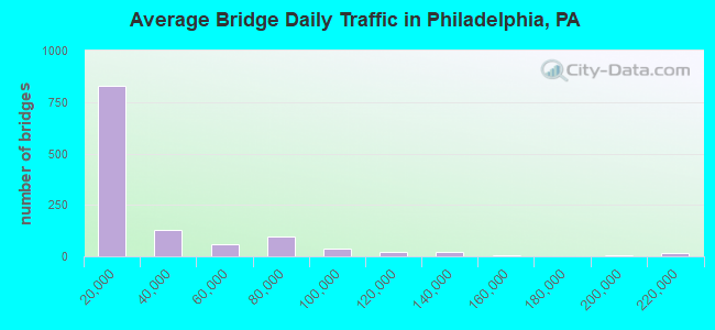
- 32,975,097Total average daily traffic
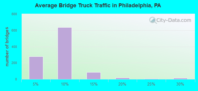
- 2,105,575Total average daily truck traffic
- National Bridge Inventory (NBI) Registered Bridges for Philadelphia
- No street view available for this location
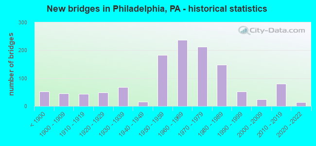
- New bridges - historical statistics
- 53Before 1900
- 451900-1909
- 431910-1919
- 481920-1929
- 681930-1939
- 151940-1949
- 1831950-1959
- 2381960-1969
- 2131970-1979
- 1491980-1989
- 531990-1999
- 252000-2009
- 802010-2019
- 142020-2022
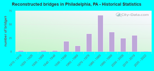
- Reconstructed bridges - Historical Statistics
- 21910-1919
- 01920-1929
- 21930-1939
- 21940-1949
- 191950-1959
- 111960-1969
- 331970-1979
- 671980-1989
- 361990-1999
- 252000-2009
- 302010-2019
- 12020-2022
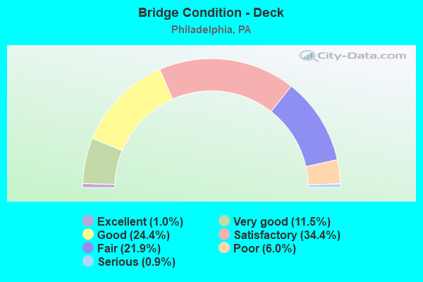
- Bridge Condition - Deck
- 1.0%Excellent
- 11.5%Very good
- 24.4%Good
- 34.4%Satisfactory
- 21.9%Fair
- 6.0%Poor
- 0.9%Serious
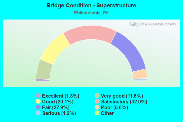
- Bridge Condition - Superstructure
- 1.5%Excellent
- 11.3%Very good
- 18.7%Good
- 32.9%Satisfactory
- 26.6%Fair
- 7.5%Poor
- 1.2%Serious
- 0.3%Imminent failure
- 0.2%Failed
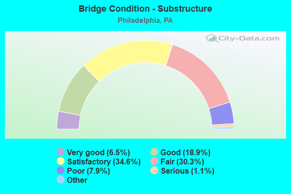
- Bridge Condition - Substructure
- 6.5%Excellent
- 18.9%Very good
- 34.6%Good
- 30.3%Satisfactory
- 7.9%Fair
- 1.1%Poor
- 0.8%Serious
- 0.2%Critical
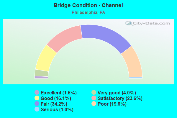
- Bridge Condition - Channel
- 1.5%Excellent
- 4.0%Very good
- 16.1%Good
- 23.6%Satisfactory
- 34.2%Fair
- 19.6%Poor
- 1.0%Serious
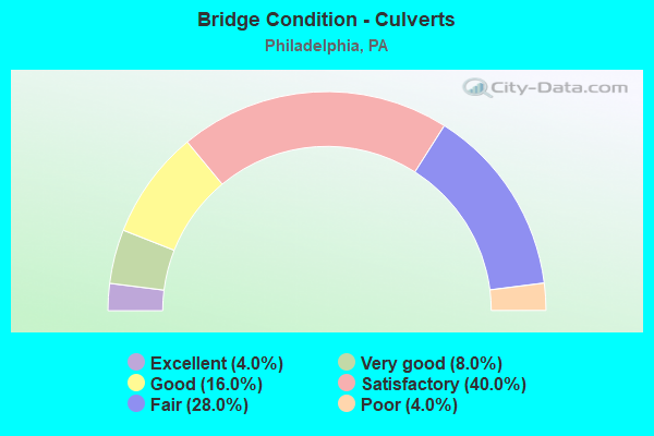
- Bridge Condition - Culverts
- 3.3%Excellent
- 6.7%Very good
- 20.0%Good
- 43.3%Satisfactory
- 23.3%Fair
- 3.3%Poor
Find on map >> Show street view
Structure Number: 559, Location: 18TH STREET 3590C07 (Lat: 39.958675, Lng: -75.168803), Route carried "under" structure: Interstate 676, Year Built: 2018, Structure Length: 0. m, Average Daily Traffic: 73,119 (year 2022), Truck Traffic: 8%, Features Intersected: VINE ST EXPWY (I-676), Facility Carried by Structure: 18TH STREET
Minimum Vertical Clearance: 4.68m (15.35ft), Kilometerpoint: 1.064, Lanes on structure: 2, Lanes under structure: 3, Material/Design: Steel, Design/Construction: Stringer/Multi-beam, Length of Maximum Span: 29.0m (95.1ft)
Find on map >> Show street view
Structure Number: 55933, Location: S of B Frank Pkwy 3590-C7 (Lat: 39.959400, Lng: -75.173906), Route carried "under" structure: Ramp State highway , Year Built: 2018, Structure Length: 0. m, Average Daily Traffic: 8,506 (year 2021), Truck Traffic: 7%, Features Intersected: Vine Street Expy (I-676), Facility Carried by Structure: 21st Street
Minimum Vertical Clearance: 4.68m (15.35ft), Kilometerpoint: 0.000, Lanes on structure: 2, Lanes under structure: 1, Material/Design: Steel, Design/Construction: Stringer/Multi-beam, Length of Maximum Span: 38.7m (127.0ft)
Find on map >> Show street view
Structure Number: 55933, Location: S of B Frank Pkwy 3590-C7 (Lat: 39.959400, Lng: -75.173906), Route carried "under" structure: Interstate 676, Year Built: 2018, Structure Length: 0. m, Average Daily Traffic: 59,822 (year 2022), Truck Traffic: 8%, Features Intersected: Vine Street Expy (I-676), Facility Carried by Structure: 21st Street
Minimum Vertical Clearance: 4.60m (15.09ft), Kilometerpoint: 0.790, Lanes on structure: 2, Lanes under structure: 3, Material/Design: Steel, Design/Construction: Stringer/Multi-beam, Length of Maximum Span: 38.7m (127.0ft)
Find on map >> Show street view
Structure Number: 55933, Location: S of B Frank Pkwy 3590-C7 (Lat: 39.959400, Lng: -75.173906), Route carried "under" structure: Interstate 676, Year Built: 2018, Structure Length: 0. m, Average Daily Traffic: 73,119 (year 2022), Truck Traffic: 8%, Features Intersected: Vine Street Expy (I-676), Facility Carried by Structure: 21st Street
Minimum Vertical Clearance: 4.63m (15.19ft), Kilometerpoint: 1.064, Lanes on structure: 2, Lanes under structure: 3, Material/Design: Steel, Design/Construction: Stringer/Multi-beam, Length of Maximum Span: 38.7m (127.0ft)
Find on map >> Show street view
Structure Number: 55937, Location: N. of Winter St. 3590-B07 (Lat: 39.959500, Lng: -75.175500), Route carried "under" structure: Interstate 676, Year Built: 2018, Structure Length: 0. m, Average Daily Traffic: 73,119 (year 2022), Truck Traffic: 8%, Features Intersected: VINE STREET EXPY (I-676), Facility Carried by Structure: 22ND STREET
Minimum Vertical Clearance: 4.44m (14.57ft), Kilometerpoint: 0.000, Lanes on structure: 4, Lanes under structure: 3, Material/Design: Steel, Design/Construction: Stringer/Multi-beam, Length of Maximum Span: 32.6m (107.0ft)
Find on map >> Show street view
Structure Number: 55937, Location: N. of Winter St. 3590-B07 (Lat: 39.959500, Lng: -75.175500), Route carried "under" structure: Interstate 676, Year Built: 2018, Structure Length: 0. m, Average Daily Traffic: 59,822 (year 2022), Truck Traffic: 8%, Features Intersected: VINE STREET EXPY (I-676), Facility Carried by Structure: 22ND STREET
Minimum Vertical Clearance: 4.49m (14.73ft), Kilometerpoint: 0.000, Lanes on structure: 4, Lanes under structure: 3, Material/Design: Steel, Design/Construction: Stringer/Multi-beam, Length of Maximum Span: 32.6m (107.0ft)
Find on map >> Show street view
Structure Number: 57427, Location: LEHIGH;SOMMERSET 3591A04 (Lat: 39.977694, Lng: -75.111806), Route carried "under" structure: State highway , Year Built: 2019, Structure Length: 0. m, Average Daily Traffic: 8,762 (year 2020), Truck Traffic: 8%, Features Intersected: LEHIGH; CONRAIL;SOMERSET, Facility Carried by Structure: DELAWARE EXPWAY.
Minimum Vertical Clearance: 9.20m (30.18ft), Kilometerpoint: 6.561, Lanes on structure: 4, Lanes under structure: 3, Material/Design: Steel continuous, Design/Construction: Stringer/Multi-beam, Length of Maximum Span: 76.2m (250.0ft)
Find on map >> Show street view
Structure Number: 57435, Location: N. OF COLUMBIA AVE 3590K5 (Lat: 39.969514, Lng: -75.126092), Route carried "under" structure: State highway , Year Built: 2020, Structure Length: 0. m, Average Daily Traffic: 9,385 (year 2022), Truck Traffic: 6%, Features Intersected: DEL,PALMER,MONTG,BERKS, Facility Carried by Structure: INTERSTATE 95 (NB)
Minimum Vertical Clearance: 5.08m (16.67ft), Kilometerpoint: 9.556, Lanes on structure: 4, Lanes under structure: 3, Material/Design: Steel continuous, Design/Construction: Stringer/Multi-beam, Length of Maximum Span: 43.6m (143.0ft)
Find on map >> Show street view
Structure Number: 57458, Location: N.OF CAMBRIA ST. 3591C04 (Lat: 39.979256, Lng: -75.107683), Route carried "under" structure: State highway , Year Built: 2019, Structure Length: 0. m, Average Daily Traffic: 8,094 (year 2022), Truck Traffic: 5%, Features Intersected: RICHMOND & ANN ST, SEPTA, Facility Carried by Structure: INTERSTATE 95 (NB)
Minimum Vertical Clearance: 5.69m (18.67ft), Kilometerpoint: 11.489, Lanes on structure: 5, Lanes under structure: 2, Material/Design: Steel continuous, Design/Construction: Stringer/Multi-beam, Length of Maximum Span: 64.0m (210.0ft)
Find on map >> Show street view
Structure Number: 57499, Location: NEAR CUMBERLAND ST3590K05 (Lat: 39.972975, Lng: -75.120481), Route carried "under" structure: State highway , Year Built: 2020, Structure Length: 0. m, Average Daily Traffic: 1,363 (year 2022), Truck Traffic: 5%, Features Intersected: GIRARD AVENUE, Facility Carried by Structure: INTERSTATE 95
Minimum Vertical Clearance: 6.63m (21.75ft), Kilometerpoint: 5.881, Lanes on structure: 4, Lanes under structure: 2, Material/Design: Steel continuous, Design/Construction: Stringer/Multi-beam, Length of Maximum Span: 55.2m (181.1ft)
Find on map >> Show street view
Structure Number: 575, Location: NEAR CUMBERLAND ST3590K05 (Lat: 39.971314, Lng: -75.123447), Route carried "under" structure: State highway , Year Built: 2019, Structure Length: 0. m, Average Daily Traffic: 10,572 (year 2022), Truck Traffic: 4%, Features Intersected: ARAMINGO AVENUE, Facility Carried by Structure: INTERSTATE 95 (NB)
Minimum Vertical Clearance: 5.61m (18.41ft), Kilometerpoint: 0.000, Lanes on structure: 4, Lanes under structure: 2, Material/Design: Steel continuous, Design/Construction: Stringer/Multi-beam, Length of Maximum Span: 58.8m (192.9ft)
Find on map >> Show street view
Structure Number: 575, Location: NEAR CUMBERLAND ST3590K05 (Lat: 39.971314, Lng: -75.123447), Route carried "under" structure: State highway , Year Built: 2019, Structure Length: 0. m, Average Daily Traffic: 12,512 (year 2022), Truck Traffic: 7%, Features Intersected: ARAMINGO AVENUE, Facility Carried by Structure: INTERSTATE 95 (NB)
Minimum Vertical Clearance: 6.45m (21.16ft), Kilometerpoint: 0.000, Lanes on structure: 4, Lanes under structure: 2, Material/Design: Steel continuous, Design/Construction: Stringer/Multi-beam, Length of Maximum Span: 58.8m (192.9ft)
Find on map >> Show street view
Structure Number: 68344, Location: 1MI.N.COUNTY LINE 41E06 (Lat: 40.129000, Lng: -74.968778), Route carried "under" structure: State highway 132, Year Built: 2021, Structure Length: 0. m, Average Daily Traffic: 19,603 (year 2022), Truck Traffic: 3%, Features Intersected: STREET ROAD, Facility Carried by Structure: LINCOLN HIGHWAY
Minimum Vertical Clearance: 6.61m (21.69ft), Kilometerpoint: 18.374, Lanes on structure: 3, Lanes under structure: 4, Material/Design: Prestressed concrete continuous, Design/Construction: Box Beam or Girders - Single/Spread, Length of Maximum Span: 26.5m (86.9ft)
Find on map >> Show street view
Structure Number: 68344, Location: 1MI.N.COUNTY LINE 41E06 (Lat: 40.129000, Lng: -74.968778), Route carried "under" structure: State highway 132, Year Built: 2021, Structure Length: 0. m, Average Daily Traffic: 16,008 (year 2022), Truck Traffic: 5%, Features Intersected: STREET ROAD, Facility Carried by Structure: LINCOLN HIGHWAY
Minimum Vertical Clearance: 6.76m (22.18ft), Kilometerpoint: 18.367, Lanes on structure: 3, Lanes under structure: 3, Material/Design: Prestressed concrete continuous, Design/Construction: Box Beam or Girders - Single/Spread, Length of Maximum Span: 26.5m (86.9ft)
Find on map >> Show street view
Structure Number: 68364, Location: NORTH PA.TURNPIKE 41E05 (Lat: 40.132500, Lng: -74.966406), Route carried "under" structure: State highway , Year Built: 2021, Structure Length: 0. m, Average Daily Traffic: 14,530 (year 2022), Truck Traffic: 7%, Features Intersected: RAMP IJ, Facility Carried by Structure: LINCOLN HIGHWAY
Minimum Vertical Clearance: 5.03m (16.50ft), Kilometerpoint: 0.000, Lanes on structure: 3, Lanes under structure: 2, Material/Design: Prestressed concrete continuous, Design/Construction: Box Beam or Girders - Single/Spread, Length of Maximum Span: 27.4m (89.9ft)
Find on map >> Show street view
Structure Number: 68364, Location: NORTH PA.TURNPIKE 41E05 (Lat: 40.132500, Lng: -74.966406), Route carried "under" structure: State highway , Year Built: 2021, Structure Length: 0. m, Average Daily Traffic: 18,099 (year 2022), Truck Traffic: 7%, Features Intersected: RAMP IJ, Facility Carried by Structure: LINCOLN HIGHWAY
Minimum Vertical Clearance: 5.03m (16.50ft), Kilometerpoint: 0.000, Lanes on structure: 3, Lanes under structure: 2, Material/Design: Prestressed concrete continuous, Design/Construction: Box Beam or Girders - Single/Spread, Length of Maximum Span: 27.4m (89.9ft)