Bridge Statistics for Philadelphia, Pennsylvania (PA)
Condition, Traffic, Stress, Structural Evaluation, Project Costs
- National Bridge Inventory (NBI) Statistics
- 1,227Number of bridges
- 25,561ft / 7,791mTotal length
- $1,156,795,000Total costs
- 32,975,097Total average daily traffic
- 2,105,575Total average daily truck traffic
- National Bridge Inventory (NBI) Registered Bridges for Philadelphia
- No street view available for this location
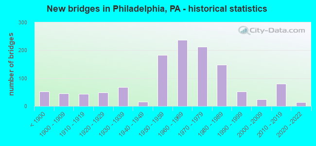
- New bridges - historical statistics
- 53Before 1900
- 451900-1909
- 431910-1919
- 481920-1929
- 681930-1939
- 151940-1949
- 1831950-1959
- 2381960-1969
- 2131970-1979
- 1491980-1989
- 531990-1999
- 252000-2009
- 802010-2019
- 142020-2022
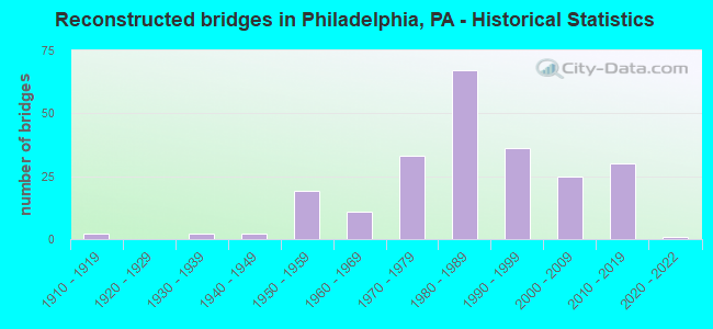
- Reconstructed bridges - Historical Statistics
- 21910-1919
- 01920-1929
- 21930-1939
- 21940-1949
- 191950-1959
- 111960-1969
- 331970-1979
- 671980-1989
- 361990-1999
- 252000-2009
- 302010-2019
- 12020-2022
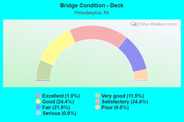
- Bridge Condition - Deck
- 1.0%Excellent
- 11.5%Very good
- 24.4%Good
- 34.4%Satisfactory
- 21.9%Fair
- 6.0%Poor
- 0.9%Serious
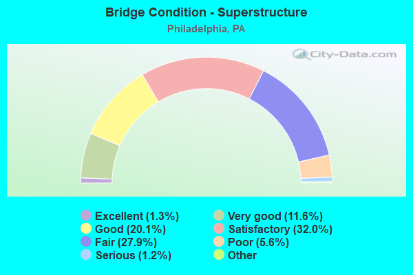
- Bridge Condition - Superstructure
- 1.5%Excellent
- 11.3%Very good
- 18.7%Good
- 32.9%Satisfactory
- 26.6%Fair
- 7.5%Poor
- 1.2%Serious
- 0.3%Imminent failure
- 0.2%Failed
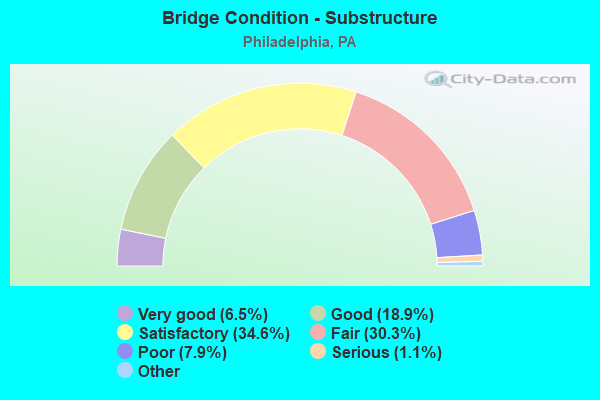
- Bridge Condition - Substructure
- 6.5%Excellent
- 18.9%Very good
- 34.6%Good
- 30.3%Satisfactory
- 7.9%Fair
- 1.1%Poor
- 0.8%Serious
- 0.2%Critical
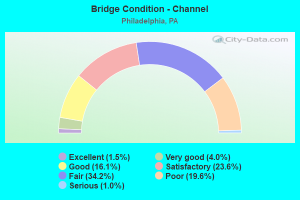
- Bridge Condition - Channel
- 1.5%Excellent
- 4.0%Very good
- 16.1%Good
- 23.6%Satisfactory
- 34.2%Fair
- 19.6%Poor
- 1.0%Serious
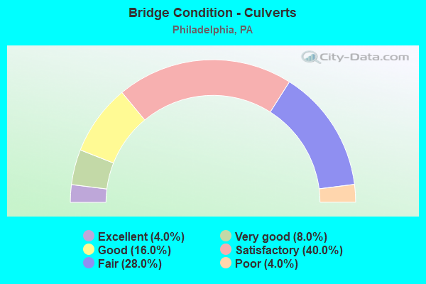
- Bridge Condition - Culverts
- 3.3%Excellent
- 6.7%Very good
- 20.0%Good
- 43.3%Satisfactory
- 23.3%Fair
- 3.3%Poor
Find on map >> Show street view
Structure Number: 38955, Location: .9MI.SE.CITY 3479 B01 (Lat: 40.061939, Lng: -75.238250), Route carried "under" structure: State highway , Year Built: 1955, Structure Length: 0. m, Average Daily Traffic: 11,067 (year 2022), Truck Traffic: 6%, Features Intersected: HENRY AVENUE SOUTHBOUND, Facility Carried by Structure: RIDGE AVENUE N.B.
Minimum Vertical Clearance: 4.34m (14.24ft), Kilometerpoint: 8.478, Lanes on structure: 2, Lanes under structure: 2, Material/Design: Prestressed concrete, Design/Construction: Stringer/Multi-beam, Length of Maximum Span: 16.8m (55.1ft)
Find on map >> Show street view
Structure Number: 38958, Location: 30TH STREET STA. 3590A08 (Lat: 39.954703, Lng: -75.182117), Route carried "under" structure: Bypass City street , Year Built: 1932, Structure Length: 0. m, Average Daily Traffic: 8,500 (year 1980), Truck Traffic: 7%, Features Intersected: SCHUYLKILL EXPWY.&AMTRAK, Facility Carried by Structure: MARKET STREET
Minimum Vertical Clearance: 4.56m (14.96ft), Kilometerpoint: 0.000, Lanes on structure: 2, Lanes under structure: 2, Material/Design: Steel, Design/Construction: Girder and Floorbeam System, Length of Maximum Span: 14.9m (48.9ft)
Find on map >> Show street view
Structure Number: 38958, Location: 30TH STREET STA. 3590A08 (Lat: 39.954703, Lng: -75.182117), Route carried "under" structure: Interstate 76, Year Built: 1932, Structure Length: 0. m, Average Daily Traffic: 73,430 (year 2022), Truck Traffic: 7%, Features Intersected: SCHUYLKILL EXPWY.&AMTRAK, Facility Carried by Structure: MARKET STREET
Minimum Vertical Clearance: 4.33m (14.21ft), Kilometerpoint: 8.005, Lanes on structure: 2, Lanes under structure: 2, Material/Design: Steel, Design/Construction: Girder and Floorbeam System, Length of Maximum Span: 14.9m (48.9ft)
Find on map >> Show street view
Structure Number: 38958, Location: 30TH STREET STA. 3590A08 (Lat: 39.954703, Lng: -75.182117), Route carried "under" structure: Interstate 76, Year Built: 1932, Structure Length: 0. m, Average Daily Traffic: 61,417 (year 2022), Truck Traffic: 7%, Features Intersected: SCHUYLKILL EXPWY.&AMTRAK, Facility Carried by Structure: MARKET STREET
Minimum Vertical Clearance: 4.35m (14.27ft), Kilometerpoint: 7.973, Lanes on structure: 2, Lanes under structure: 2, Material/Design: Steel, Design/Construction: Girder and Floorbeam System, Length of Maximum Span: 14.9m (48.9ft)
Find on map >> Show street view
Structure Number: 38964, Location: AIRPORT HIGH SPEED3699B07 (Lat: 39.899331, Lng: -75.238669), Route carried "under" structure: ServiceOther road , Year Built: 1985, Structure Length: 0. m, Average Daily Traffic: 1,000 (year 2005), Truck Traffic: 10%, Features Intersected: SEPTA;FRONTAGE ROAD, Facility Carried by Structure: ISLAND AVENUE
Minimum Vertical Clearance: 6.95m (22.80ft), Kilometerpoint: 0.000, Lanes on structure: 2, Lanes under structure: 1, Material/Design: Prestressed concrete, Design/Construction: Box Beam or Girders - Multiple, Length of Maximum Span: 30.5m (100.1ft)
Find on map >> Show street view
Structure Number: 38964, Location: AIRPORT HIGH SPEED3699B07 (Lat: 39.899331, Lng: -75.238669), Route carried "under" structure: ServiceOther road , Year Built: 1985, Structure Length: 0. m, Average Daily Traffic: 1,500 (year 1980), Truck Traffic: 10%, Features Intersected: SEPTA;FRONTAGE ROAD, Facility Carried by Structure: ISLAND AVENUE
Minimum Vertical Clearance: 6.40m (21.00ft), Kilometerpoint: 0.000, Lanes on structure: 2, Lanes under structure: 1, Material/Design: Prestressed concrete, Design/Construction: Box Beam or Girders - Multiple, Length of Maximum Span: 30.5m (100.1ft)
Find on map >> Show street view
Structure Number: 38971, Location: SPRING GARDEN INCH3590A08 (Lat: 39.963983, Lng: -75.184606), Route carried "under" structure: Interstate 76, Year Built: 1958, Structure Length: 0. m, Average Daily Traffic: 73,430 (year 2022), Truck Traffic: 7%, Features Intersected: SCHUYLKILL EXPRESSWAY, Facility Carried by Structure: SPRING GARDEN STR.
Minimum Vertical Clearance: 5.03m (16.50ft), Kilometerpoint: 6.415, Lanes on structure: 3, Lanes under structure: 3, Material/Design: Steel continuous, Design/Construction: Girder and Floorbeam System, Length of Maximum Span: 33.5m (109.9ft)
Find on map >> Show street view
Structure Number: 38971, Location: SPRING GARDEN INCH3590A08 (Lat: 39.963983, Lng: -75.184606), Route carried "under" structure: Interstate 76, Year Built: 1958, Structure Length: 0. m, Average Daily Traffic: 61,417 (year 2022), Truck Traffic: 7%, Features Intersected: SCHUYLKILL EXPRESSWAY, Facility Carried by Structure: SPRING GARDEN STR.
Minimum Vertical Clearance: 6.31m (20.70ft), Kilometerpoint: 6.400, Lanes on structure: 3, Lanes under structure: 3, Material/Design: Steel continuous, Design/Construction: Girder and Floorbeam System, Length of Maximum Span: 33.5m (109.9ft)
Find on map >> Show street view
Structure Number: 38972, Location: NEAR ART MUSEUM 3590A06 (Lat: 39.964333, Lng: -75.183550), Route carried "under" structure: City street , Year Built: 1966, Structure Length: 0. m, Average Daily Traffic: 18,900 (year 1980), Truck Traffic: 1%, Features Intersected: SCHUYLKILL RIVER, MLK DR, Facility Carried by Structure: SPRING GARDEN STR.
Minimum Vertical Clearance: 4.91m (16.11ft), Kilometerpoint: 0.000, Lanes on structure: 3, Lanes under structure: 3, Material/Design: Steel continuous, Design/Construction: Girder and Floorbeam System, Length of Maximum Span: 58.5m (191.9ft)
Find on map >> Show street view
Structure Number: 38973, Location: PHILA.ART MUSEUM 3590A06 (Lat: 39.963883, Lng: -75.180903), Route carried "under" structure: State highway , Year Built: 1965, Structure Length: 0. m, Average Daily Traffic: 25,000 (year 1980), Features Intersected: WEST RIVER DRIVE RAMP, Facility Carried by Structure: SPRING GARDEN ST.
Minimum Vertical Clearance: 4.05m (13.29ft), Kilometerpoint: 0.000, Lanes on structure: 2, Lanes under structure: 1, Material/Design: Steel, Design/Construction: Stringer/Multi-beam, Length of Maximum Span: 21.9m (71.9ft)
Find on map >> Show street view
Structure Number: 38987, Location: NEAR JERRYS CORNER3699H03 (Lat: 39.918556, Lng: -75.206528), Route carried "under" structure: ServiceCity street , Year Built: 1983, Structure Length: 0. m, Average Daily Traffic: 100 (year 1980), Truck Traffic: 7%, Features Intersected: SCHUYLKILL RIVER;ROADS, Facility Carried by Structure: PASSYUNK AVENUE
Minimum Vertical Clearance: 6.38m (20.93ft), Kilometerpoint: 0.000, Lanes on structure: 3, Lanes under structure: 2, Material/Design: Steel, Design/Construction: Movable - Bascule, Length of Maximum Span: 67.7m (222.1ft)
Find on map >> Show street view
Structure Number: 38987, Location: NEAR JERRYS CORNER3699H03 (Lat: 39.918556, Lng: -75.206528), Route carried "under" structure: ServiceOther road , Year Built: 1983, Structure Length: 0. m, Average Daily Traffic: 100 (year 1980), Truck Traffic: 7%, Features Intersected: SCHUYLKILL RIVER;ROADS, Facility Carried by Structure: PASSYUNK AVENUE
Minimum Vertical Clearance: 4.63m (15.19ft), Kilometerpoint: 0.000, Lanes on structure: 3, Lanes under structure: 2, Material/Design: Steel, Design/Construction: Movable - Bascule, Length of Maximum Span: 67.7m (222.1ft)
Find on map >> Show street view
Structure Number: 38992, Location: NEAR 24TH STREET 3699K03 (Lat: 39.921603, Lng: -75.190475), Route carried "under" structure: State highway 291, Year Built: 1960, Structure Length: 0. m, Average Daily Traffic: 18,789 (year 2022), Truck Traffic: 6%, Features Intersected: 26TH STREET, Facility Carried by Structure: PASSYUNK AVENUE
Minimum Vertical Clearance: 4.37m (14.34ft), Kilometerpoint: 1.761, Lanes on structure: 3, Lanes under structure: 2, Material/Design: Steel, Design/Construction: Stringer/Multi-beam, Length of Maximum Span: 11.9m (39.0ft)
Find on map >> Show street view
Structure Number: 38992, Location: NEAR 24TH STREET 3699K03 (Lat: 39.921603, Lng: -75.190475), Route carried "under" structure: State highway 291, Year Built: 1960, Structure Length: 0. m, Average Daily Traffic: 23,892 (year 2022), Truck Traffic: 5%, Features Intersected: 26TH STREET, Facility Carried by Structure: PASSYUNK AVENUE
Minimum Vertical Clearance: 4.52m (14.83ft), Kilometerpoint: 1.738, Lanes on structure: 3, Lanes under structure: 2, Material/Design: Steel, Design/Construction: Stringer/Multi-beam, Length of Maximum Span: 11.9m (39.0ft)
Find on map >> Show street view
Structure Number: 39001, Location: SW.PHILADELPHIA 3699A02 (Lat: 39.929508, Lng: -75.243383), Route carried "under" structure: State highway , Year Built: 1926, Structure Length: 0. m, Average Daily Traffic: 13,579 (year 2022), Truck Traffic: 2%, Features Intersected: COBBS CREEK PARKWAY, Facility Carried by Structure: 65TH STREET
Minimum Vertical Clearance: 4.55m (14.93ft), Kilometerpoint: 0.795, Lanes on structure: 2, Lanes under structure: 2, Material/Design: Concrete continuous, Design/Construction: Stringer/Multi-beam, Length of Maximum Span: 15.8m (51.8ft)
Find on map >> Show street view
Structure Number: 39006, Location: VINE STR.EXPWAY. 3590D07 (Lat: 39.958056, Lng: -75.165556), Route carried "under" structure: Ramp State highway , Year Built: 1989, Structure Length: 0. m, Average Daily Traffic: 9,597 (year 2021), Truck Traffic: 7%, Features Intersected: RAMP EB-15 OFF, Facility Carried by Structure: 16TH STREET
Minimum Vertical Clearance: 4.70m (15.42ft), Kilometerpoint: 0.000, Lanes on structure: 4, Lanes under structure: 2, Material/Design: Steel, Design/Construction: Stringer/Multi-beam, Length of Maximum Span: 16.8m (55.1ft)
Find on map >> Show street view
Structure Number: 39007, Location: VINE STREET EXWY. 3590D07 (Lat: 39.958333, Lng: -75.166667), Route carried "under" structure: Interstate 676, Year Built: 1990, Structure Length: 0. m, Average Daily Traffic: 73,119 (year 2022), Truck Traffic: 8%, Features Intersected: VINE STR;RAMP 16V, Facility Carried by Structure: 16TH STREET
Minimum Vertical Clearance: 4.40m (14.44ft), Kilometerpoint: 1.064, Lanes on structure: 3, Lanes under structure: 2, Material/Design: Steel, Design/Construction: Stringer/Multi-beam, Length of Maximum Span: 36.6m (120.1ft)
Find on map >> Show street view
Structure Number: 39007, Location: VINE STREET EXWY. 3590D07 (Lat: 39.958333, Lng: -75.166667), Route carried "under" structure: Ramp State highway , Year Built: 1990, Structure Length: 0. m, Average Daily Traffic: 8,707 (year 2021), Truck Traffic: 7%, Features Intersected: VINE STR;RAMP 16V, Facility Carried by Structure: 16TH STREET
Minimum Vertical Clearance: 4.50m (14.76ft), Kilometerpoint: 0.000, Lanes on structure: 3, Lanes under structure: 1, Material/Design: Steel, Design/Construction: Stringer/Multi-beam, Length of Maximum Span: 36.6m (120.1ft)
Find on map >> Show street view
Structure Number: 39007, Location: VINE STREET EXWY. 3590D07 (Lat: 39.958333, Lng: -75.166667), Route carried "under" structure: Interstate 676, Year Built: 1990, Structure Length: 0. m, Average Daily Traffic: 87,727 (year 2022), Truck Traffic: 5%, Features Intersected: VINE STR;RAMP 16V, Facility Carried by Structure: 16TH STREET
Minimum Vertical Clearance: 4.52m (14.83ft), Kilometerpoint: 0.790, Lanes on structure: 3, Lanes under structure: 3, Material/Design: Steel, Design/Construction: Stringer/Multi-beam, Length of Maximum Span: 36.6m (120.1ft)
Find on map >> Show street view
Structure Number: 39009, Location: NR.30TH STR.STA. 3590A08 (Lat: 39.955556, Lng: -75.186944), Route carried "under" structure: City street , Year Built: 1955, Structure Length: 0. m, Average Daily Traffic: 20 (year 2004), Truck Traffic: 5%, Features Intersected: AMTRAK(NY BRANCH);ROAD, Facility Carried by Structure: JFK BLVD.AT 30TH
Minimum Vertical Clearance: 6.28m (20.60ft), Kilometerpoint: 0.000, Lanes on structure: 2, Lanes under structure: 2, Material/Design: Steel, Design/Construction: Stringer/Multi-beam, Length of Maximum Span: 18.9m (62.0ft)
Find on map >> Show street view
Structure Number: 39012, Location: VINE ST.EXPRESSWAY3590D07 (Lat: 39.958094, Lng: -75.164106), Route carried "under" structure: Interstate 676, Year Built: 1989, Structure Length: 0. m, Average Daily Traffic: 63,224 (year 2022), Truck Traffic: 6%, Features Intersected: VINE STR;RAMP V-15-W, Facility Carried by Structure: 15TH STREET
Minimum Vertical Clearance: 4.44m (14.57ft), Kilometerpoint: 1.905, Lanes on structure: 3, Lanes under structure: 2, Material/Design: Steel, Design/Construction: Stringer/Multi-beam, Length of Maximum Span: 36.0m (118.1ft)
Find on map >> Show street view
Structure Number: 39012, Location: VINE ST.EXPRESSWAY3590D07 (Lat: 39.958094, Lng: -75.164106), Route carried "under" structure: Ramp State highway , Year Built: 1989, Structure Length: 0. m, Average Daily Traffic: 9,638 (year 2021), Truck Traffic: 7%, Features Intersected: VINE STR;RAMP V-15-W, Facility Carried by Structure: 15TH STREET
Minimum Vertical Clearance: 4.60m (15.09ft), Kilometerpoint: 0.000, Lanes on structure: 3, Lanes under structure: 1, Material/Design: Steel, Design/Construction: Stringer/Multi-beam, Length of Maximum Span: 36.0m (118.1ft)
Find on map >> Show street view
Structure Number: 39012, Location: VINE ST.EXPRESSWAY3590D07 (Lat: 39.958094, Lng: -75.164106), Route carried "under" structure: Interstate 676, Year Built: 1989, Structure Length: 0. m, Average Daily Traffic: 87,727 (year 2022), Truck Traffic: 5%, Features Intersected: VINE STR;RAMP V-15-W, Facility Carried by Structure: 15TH STREET
Minimum Vertical Clearance: 4.44m (14.57ft), Kilometerpoint: 1.635, Lanes on structure: 3, Lanes under structure: 2, Material/Design: Steel, Design/Construction: Stringer/Multi-beam, Length of Maximum Span: 36.0m (118.1ft)
Find on map >> Show street view
Structure Number: 39014, Location: IN CENTER CITY 3590 B08 (Lat: 39.954772, Lng: -75.174856), Route carried "under" structure: State highway , Year Built: 1957, Structure Length: 0. m, Average Daily Traffic: 5,800 (year 1980), Features Intersected: 21ST STREET, Facility Carried by Structure: JFK BLVD.
Minimum Vertical Clearance: 5.32m (17.45ft), Kilometerpoint: 0.000, Lanes on structure: 3, Lanes under structure: 2, Material/Design: Prestressed concrete, Design/Construction: Stringer/Multi-beam, Length of Maximum Span: 15.8m (51.8ft)
Find on map >> Show street view
Structure Number: 39015, Location: IN CENTER CITY 3590B08 (Lat: 39.954969, Lng: -75.176433), Route carried "under" structure: State highway , Year Built: 1957, Structure Length: 0. m, Average Daily Traffic: 8,600 (year 1980), Features Intersected: 22ND STREET, Facility Carried by Structure: JFK BLVD.
Minimum Vertical Clearance: 5.66m (18.57ft), Kilometerpoint: 0.000, Lanes on structure: 3, Lanes under structure: 2, Material/Design: Prestressed concrete, Design/Construction: Stringer/Multi-beam, Length of Maximum Span: 18.9m (62.0ft)
Find on map >> Show street view
Structure Number: 39016, Location: IN CENTER CITY 3590B08 (Lat: 39.955117, Lng: -75.177586), Route carried "under" structure: State highway , Year Built: 1957, Structure Length: 0. m, Average Daily Traffic: 7,600 (year 1980), Features Intersected: 23RD STREET, Facility Carried by Structure: JFK BLVD.
Minimum Vertical Clearance: 6.09m (19.98ft), Kilometerpoint: 0.000, Lanes on structure: 3, Lanes under structure: 2, Material/Design: Prestressed concrete, Design/Construction: Stringer/Multi-beam, Length of Maximum Span: 15.8m (51.8ft)
Find on map >> Show street view
Structure Number: 39018, Location: E.SIDE OF 30TH ST.3590A08 (Lat: 39.955867, Lng: -75.180647), Route carried "under" structure: Interstate 76, Year Built: 1933, Structure Length: 0. m, Average Daily Traffic: 73,430 (year 2022), Truck Traffic: 7%, Features Intersected: SCHUYLKILL EXPRESSWAY, Facility Carried by Structure: SCHUYLKILL AV WEST
Minimum Vertical Clearance: 4.40m (14.44ft), Kilometerpoint: 8.005, Lanes on structure: 3, Lanes under structure: 2, Material/Design: Steel, Design/Construction: Girder and Floorbeam System, Length of Maximum Span: 14.9m (48.9ft)
Find on map >> Show street view
Structure Number: 39018, Location: E.SIDE OF 30TH ST.3590A08 (Lat: 39.955867, Lng: -75.180647), Route carried "under" structure: Interstate 76, Year Built: 1933, Structure Length: 0. m, Average Daily Traffic: 61,417 (year 2022), Truck Traffic: 7%, Features Intersected: SCHUYLKILL EXPRESSWAY, Facility Carried by Structure: SCHUYLKILL AV WEST
Minimum Vertical Clearance: 4.60m (15.09ft), Kilometerpoint: 7.973, Lanes on structure: 3, Lanes under structure: 2, Material/Design: Steel, Design/Construction: Girder and Floorbeam System, Length of Maximum Span: 14.9m (48.9ft)
Find on map >> Show street view
Structure Number: 39022, Location: NE.CORNER 30TH ST.3590A08 (Lat: 39.956275, Lng: -75.180511), Route carried "under" structure: Interstate 76, Year Built: 1932, Structure Length: 0. m, Average Daily Traffic: 73,430 (year 2022), Truck Traffic: 7%, Features Intersected: SCHUYLKILL EXPWY, RAMP J, Facility Carried by Structure: SCHUYLKILL AV WEST
Minimum Vertical Clearance: 4.32m (14.17ft), Kilometerpoint: 8.005, Lanes on structure: 3, Lanes under structure: 2, Material/Design: Steel, Design/Construction: Girder and Floorbeam System, Length of Maximum Span: 45.7m (149.9ft)
Find on map >> Show street view
Structure Number: 39022, Location: NE.CORNER 30TH ST.3590A08 (Lat: 39.956275, Lng: -75.180511), Route carried "under" structure: Ramp State highway , Year Built: 1932, Structure Length: 0. m, Average Daily Traffic: 13,003 (year 2022), Truck Traffic: 7%, Features Intersected: SCHUYLKILL EXPWY, RAMP J, Facility Carried by Structure: SCHUYLKILL AV WEST
Minimum Vertical Clearance: 4.51m (14.80ft), Kilometerpoint: 0.000, Lanes on structure: 3, Lanes under structure: 1, Material/Design: Steel, Design/Construction: Girder and Floorbeam System, Length of Maximum Span: 45.7m (149.9ft)
Find on map >> Show street view
Structure Number: 39022, Location: NE.CORNER 30TH ST.3590A08 (Lat: 39.956275, Lng: -75.180511), Route carried "under" structure: Interstate 76, Year Built: 1932, Structure Length: 0. m, Average Daily Traffic: 61,417 (year 2022), Truck Traffic: 7%, Features Intersected: SCHUYLKILL EXPWY, RAMP J, Facility Carried by Structure: SCHUYLKILL AV WEST
Minimum Vertical Clearance: 4.54m (14.90ft), Kilometerpoint: 7.973, Lanes on structure: 3, Lanes under structure: 2, Material/Design: Steel, Design/Construction: Girder and Floorbeam System, Length of Maximum Span: 45.7m (149.9ft)
Find on map >> Show street view
Structure Number: 39023, Location: N.SIDE 30TH ST.STA3590A07 (Lat: 39.956944, Lng: -75.181667), Route carried "under" structure: ServiceOther road , Year Built: 1927, Structure Length: 0. m, Average Daily Traffic: 100 (year 1980), Features Intersected: AMTRAK;ACCESS ROAD, Facility Carried by Structure: ARCH STREET
Minimum Vertical Clearance: 4.18m (13.71ft), Kilometerpoint: 0.000, Lanes on structure: 4, Lanes under structure: 2, Material/Design: Steel, Design/Construction: Stringer/Multi-beam, Length of Maximum Span: 15.2m (49.9ft)
Find on map >> Show street view
Structure Number: 39028, Location: SCHYKL;JFK BLVD. 3590A08 (Lat: 39.955144, Lng: -75.180925), Route carried "under" structure: Interstate 76, Year Built: 1931, Structure Length: 0. m, Average Daily Traffic: 61,417 (year 2022), Truck Traffic: 7%, Features Intersected: SCHUYLKILL EXPRESSWAY, Facility Carried by Structure: SCHUYLKILL AV.WEST
Minimum Vertical Clearance: 4.72m (15.49ft), Kilometerpoint: 7.973, Lanes on structure: 4, Lanes under structure: 2, Material/Design: Steel continuous, Design/Construction: Girder and Floorbeam System, Length of Maximum Span: 14.9m (48.9ft)
Find on map >> Show street view
Structure Number: 39028, Location: SCHYKL;JFK BLVD. 3590A08 (Lat: 39.955144, Lng: -75.180925), Route carried "under" structure: Interstate 76, Year Built: 1931, Structure Length: 0. m, Average Daily Traffic: 73,430 (year 2022), Truck Traffic: 7%, Features Intersected: SCHUYLKILL EXPRESSWAY, Facility Carried by Structure: SCHUYLKILL AV.WEST
Minimum Vertical Clearance: 4.67m (15.32ft), Kilometerpoint: 8.005, Lanes on structure: 4, Lanes under structure: 2, Material/Design: Steel continuous, Design/Construction: Girder and Floorbeam System, Length of Maximum Span: 14.9m (48.9ft)
Find on map >> Show street view
Structure Number: 39032, Location: ROOSEVELT BLVD. 3480A09 (Lat: 40.011739, Lng: -75.182211), Route carried "under" structure: US 1, Year Built: 1960, Structure Length: 0. m, Average Daily Traffic: 59,331 (year 2022), Truck Traffic: 4%, Features Intersected: US 1: ROOSEVELT BLVD.EXT, Facility Carried by Structure: HENRY AVENUE
Minimum Vertical Clearance: 4.91m (16.11ft), Kilometerpoint: 6.906, Lanes on structure: 2, Lanes under structure: 3, Material/Design: Steel, Design/Construction: Stringer/Multi-beam, Length of Maximum Span: 30.2m (99.1ft)
Find on map >> Show street view
Structure Number: 39032, Location: ROOSEVELT BLVD. 3480A09 (Lat: 40.011739, Lng: -75.182211), Route carried "under" structure: US 1, Year Built: 1960, Structure Length: 0. m, Average Daily Traffic: 50,852 (year 2022), Truck Traffic: 4%, Features Intersected: US 1: ROOSEVELT BLVD.EXT, Facility Carried by Structure: HENRY AVENUE
Minimum Vertical Clearance: 6.26m (20.54ft), Kilometerpoint: 6.999, Lanes on structure: 2, Lanes under structure: 3, Material/Design: Steel, Design/Construction: Stringer/Multi-beam, Length of Maximum Span: 30.2m (99.1ft)
Find on map >> Show street view
Structure Number: 39033, Location: FAIRMOUNT PARK 3479J07 (Lat: 40.024333, Lng: -75.196103), Route carried "under" structure: State highway , Year Built: 1931, Structure Length: 0. m, Average Daily Traffic: 9,800 (year 1980), Features Intersected: WISSAHICKON CR;LINCOLN D, Facility Carried by Structure: HENRY AVENUE
Minimum Vertical Clearance: 30+ m (98+ ft), Kilometerpoint: 0.000, Lanes on structure: 2, Lanes under structure: 4, Material/Design: Concrete, Design/Construction: Arch - Deck, Length of Maximum Span: 87.8m (288.1ft)
Find on map >> Show street view
Structure Number: 39035, Location: WEST VALLEY AVE. 3479 F04 (Lat: 40.043408, Lng: -75.217486), Route carried "under" structure: State highway , Year Built: 1958, Structure Length: 0. m, Average Daily Traffic: 900 (year 1980), Features Intersected: BIKE PATH,WISSAHICKON, Facility Carried by Structure: HENRY AVENUE
Minimum Vertical Clearance: 12.19m (39.99ft), Kilometerpoint: 0.000, Lanes on structure: 2, Lanes under structure: 2, Material/Design: Concrete, Design/Construction: Tee Beam, Length of Maximum Span: 36.0m (118.1ft)
Find on map >> Show street view
Structure Number: 39042, Location: ROOSEVELT BLVD. 3480C08 (Lat: 40.017706, Lng: -75.172400), Route carried "under" structure: US 1, Year Built: 1960, Structure Length: 0. m, Average Daily Traffic: 45,272 (year 2022), Truck Traffic: 4%, Features Intersected: ROOSEVELT BLVD.EXTEN., Facility Carried by Structure: WISSAHICKON AVENUE
Minimum Vertical Clearance: 4.32m (14.17ft), Kilometerpoint: 8.734, Lanes on structure: 4, Lanes under structure: 3, Material/Design: Steel, Design/Construction: Stringer/Multi-beam, Length of Maximum Span: 37.2m (122.0ft)
Find on map >> Show street view
Structure Number: 39042, Location: ROOSEVELT BLVD. 3480C08 (Lat: 40.017706, Lng: -75.172400), Route carried "under" structure: US 1, Year Built: 1960, Structure Length: 0. m, Average Daily Traffic: 53,173 (year 2022), Truck Traffic: 3%, Features Intersected: ROOSEVELT BLVD.EXTEN., Facility Carried by Structure: WISSAHICKON AVENUE
Minimum Vertical Clearance: 4.44m (14.57ft), Kilometerpoint: 8.629, Lanes on structure: 4, Lanes under structure: 4, Material/Design: Steel, Design/Construction: Stringer/Multi-beam, Length of Maximum Span: 37.2m (122.0ft)
Find on map >> Show street view
Structure Number: 39055, Location: INT.WEST OF I-76 3479H09 (Lat: 40.011783, Lng: -75.205103), Route carried "under" structure: State highway , Year Built: 1955, Structure Length: 0. m, Average Daily Traffic: 8,063 (year 2022), Truck Traffic: 1%, Features Intersected: SCHUYLKILL RIVER; NSRC, Facility Carried by Structure: CITY LINE AVE.N.B.
Minimum Vertical Clearance: 11.17m (36.65ft), Kilometerpoint: 8.943, Lanes on structure: 3, Lanes under structure: 2, Material/Design: Steel continuous, Design/Construction: Stringer/Multi-beam, Length of Maximum Span: 51.8m (169.9ft)
Find on map >> Show street view
Structure Number: 39055, Location: INT.WEST OF I-76 3479H09 (Lat: 40.011783, Lng: -75.205103), Route carried "under" structure: Ramp State highway , Year Built: 1955, Structure Length: 0. m, Average Daily Traffic: 7,875 (year 2022), Truck Traffic: 7%, Features Intersected: SCHUYLKILL RIVER; NSRC, Facility Carried by Structure: CITY LINE AVE.N.B.
Minimum Vertical Clearance: 5.84m (19.16ft), Kilometerpoint: 0.000, Lanes on structure: 3, Lanes under structure: 1, Material/Design: Steel continuous, Design/Construction: Stringer/Multi-beam, Length of Maximum Span: 51.8m (169.9ft)
Find on map >> Show street view
Structure Number: 3906, Location: EAST OF I-76 3479 G09 (Lat: 40.011800, Lng: -75.205869), Route carried "under" structure: State highway , Year Built: 1955, Structure Length: 0. m, Average Daily Traffic: 8,063 (year 2022), Truck Traffic: 1%, Features Intersected: SCHUYLKILL R;RD; NSRC, Facility Carried by Structure: CITY LINE AVE.S.B.
Minimum Vertical Clearance: 16.46m (54.00ft), Kilometerpoint: 8.943, Lanes on structure: 3, Lanes under structure: 2, Material/Design: Steel continuous, Design/Construction: Stringer/Multi-beam, Length of Maximum Span: 56.1m (184.1ft)
Find on map >> Show street view
Structure Number: 3906, Location: EAST OF I-76 3479 G09 (Lat: 40.011800, Lng: -75.205869), Route carried "under" structure: Ramp State highway , Year Built: 1955, Structure Length: 0. m, Average Daily Traffic: 7,875 (year 2022), Truck Traffic: 7%, Features Intersected: SCHUYLKILL R;RD; NSRC, Facility Carried by Structure: CITY LINE AVE.S.B.
Minimum Vertical Clearance: 9.14m (29.99ft), Kilometerpoint: 0.000, Lanes on structure: 3, Lanes under structure: 1, Material/Design: Steel continuous, Design/Construction: Stringer/Multi-beam, Length of Maximum Span: 56.1m (184.1ft)
Find on map >> Show street view
Structure Number: 39071, Location: AT ROOSEVELT BLVD 3480D08 (Lat: 40.017869, Lng: -75.166350), Route carried "under" structure: Ramp State highway , Year Built: 1959, Structure Length: 0. m, Average Daily Traffic: 9,148 (year 2022), Truck Traffic: 7%, Features Intersected: ROOSEVELT BLVD.RAMP M NB, Facility Carried by Structure: ROBERTS AVE.W.B.
Minimum Vertical Clearance: 5.00m (16.40ft), Kilometerpoint: 0.000, Lanes on structure: 1, Lanes under structure: 1, Material/Design: Steel continuous, Design/Construction: Stringer/Multi-beam, Length of Maximum Span: 16.5m (54.1ft)
Find on map >> Show street view
Structure Number: 39075, Location: FAIRMOUNT PARK E. 3479K05 (Lat: 40.032939, Lng: -75.187853), Route carried "under" structure: City street , Year Built: 1949, Structure Length: 0. m, Average Daily Traffic: 9,900 (year 1980), Truck Traffic: 7%, Features Intersected: LINCOLN DR,MONOSHONE CK., Facility Carried by Structure: WALNUT LANE
Minimum Vertical Clearance: 13.53m (44.39ft), Kilometerpoint: 0.000, Lanes on structure: 2, Lanes under structure: 4, Material/Design: Prestressed concrete continuous, Design/Construction: Stringer/Multi-beam, Length of Maximum Span: 48.2m (158.1ft)
Find on map >> Show street view
Structure Number: 39081, Location: .3MI.NE.GERMANTOWN3370A10 (Lat: 40.063928, Lng: -75.187053), Route carried "under" structure: State highway , Year Built: 1939, Structure Length: 0. m, Average Daily Traffic: 980 (year 1980), Features Intersected: SPRAGUE STREET(ONE WAY), Facility Carried by Structure: MOUNT AIRY AVENUE
Minimum Vertical Clearance: 4.24m (13.91ft), Kilometerpoint: 0.000, Lanes on structure: 2, Lanes under structure: 1, Material/Design: Concrete continuous, Design/Construction: Stringer/Multi-beam, Length of Maximum Span: 15.8m (51.8ft)
Find on map >> Show street view
Structure Number: 39092, Location: N.PLATT BRIDGE 3699D08 (Lat: 39.891083, Lng: -75.228969), Route carried "under" structure: Ramp State highway , Year Built: 1985, Structure Length: 0. m, Average Daily Traffic: 22,548 (year 2022), Truck Traffic: 5%, Features Intersected: RAMP V OFF TO PLATT BRDG, Facility Carried by Structure: RELOCATED PENROSE
Minimum Vertical Clearance: 4.77m (15.65ft), Kilometerpoint: 0.000, Lanes on structure: 1, Lanes under structure: 1, Material/Design: Prestressed concrete, Design/Construction: Stringer/Multi-beam, Length of Maximum Span: 30.5m (100.1ft)
Find on map >> Show street view
Structure Number: 39095, Location: at Luzerne Steet 29A01 (Lat: 40.011356, Lng: -75.130564), Route carried "under" structure: City street , Year Built: 1926, Structure Length: 0. m, Average Daily Traffic: 12,500 (year 1977), Features Intersected: Luzerne Street, Facility Carried by Structure: 2nd Street
Minimum Vertical Clearance: 3.96m (12.99ft), Kilometerpoint: 0.000, Lanes on structure: 2, Lanes under structure: 2, Material/Design: Steel, Design/Construction: Stringer/Multi-beam, Length of Maximum Span: 13.7m (44.9ft)
Find on map >> Show street view
Structure Number: 39099, Location: East of Henry Ave 3480-B8 (Lat: 40.014492, Lng: -75.178256), Route carried "under" structure: US 1, Year Built: 1960, Structure Length: 0. m, Average Daily Traffic: 50,852 (year 2022), Truck Traffic: 4%, Features Intersected: Roosevelt Blvd Ext (US1), Facility Carried by Structure: Fox Street
Minimum Vertical Clearance: 4.89m (16.04ft), Kilometerpoint: 8.109, Lanes on structure: 4, Lanes under structure: 3, Material/Design: Steel, Design/Construction: Stringer/Multi-beam, Length of Maximum Span: 30.2m (99.1ft)
Find on map >> Show street view
Structure Number: 39099, Location: East of Henry Ave 3480-B8 (Lat: 40.014492, Lng: -75.178256), Route carried "under" structure: US 1, Year Built: 1960, Structure Length: 0. m, Average Daily Traffic: 59,331 (year 2022), Truck Traffic: 4%, Features Intersected: Roosevelt Blvd Ext (US1), Facility Carried by Structure: Fox Street
Minimum Vertical Clearance: 4.43m (14.53ft), Kilometerpoint: 8.010, Lanes on structure: 4, Lanes under structure: 3, Material/Design: Steel, Design/Construction: Stringer/Multi-beam, Length of Maximum Span: 30.2m (99.1ft)
Find on map >> Show street view
Structure Number: 39113, Location: N of Market Street 28E12 (Lat: 39.954467, Lng: -75.169736), Route carried "under" structure: ServiceOther road , Year Built: 1957, Structure Length: 0. m, Average Daily Traffic: 2,000 (year 1985), Features Intersected: Penn Ctr Undrgrnd St Sys, Facility Carried by Structure: 18th Street
Minimum Vertical Clearance: 4.27m (14.01ft), Kilometerpoint: 0.000, Lanes on structure: 2, Lanes under structure: 2, Material/Design: Steel, Design/Construction: Girder and Floorbeam System, Length of Maximum Span: 15.2m (49.9ft)
Find on map >> Show street view
Structure Number: 39119, Location: BTWN.18TH & 19TH 28E12 (Lat: 39.954700, Lng: -75.171300), Route carried "under" structure: ServiceCity street , Year Built: 1957, Structure Length: 0. m, Features Intersected: Penn Ctr Undergr'nd Ramp, Facility Carried by Structure: Commerce Street
Minimum Vertical Clearance: 3.81m (12.50ft), Kilometerpoint: 0.000, Lanes on structure: 2, Lanes under structure: 2, Material/Design: Concrete, Design/Construction: Tee Beam, Length of Maximum Span: 8.2m (26.9ft)
Find on map >> Show street view
Structure Number: 39123, Location: at 2nd Street 28A01 (Lat: 40.014389, Lng: -75.129944), Route carried "under" structure: City street , Year Built: 1908, Structure Length: 0. m, Features Intersected: Second Street, Facility Carried by Structure: Hunting Park Ave
Minimum Vertical Clearance: 5.66m (18.57ft), Kilometerpoint: 0.000, Lanes on structure: 4, Lanes under structure: 2, Material/Design: Concrete, Design/Construction: Arch - Deck, Length of Maximum Span: 18.3m (60.0ft)
Find on map >> Show street view
Structure Number: 39124, Location: SCOTTS LANE 28C01 (Lat: 40.010197, Lng: -75.185697), Route carried "under" structure: US 1, Year Built: 1960, Structure Length: 0. m, Average Daily Traffic: 59,331 (year 2022), Truck Traffic: 4%, Features Intersected: Roosevelt Bvd Ext (US-1), Facility Carried by Structure: Scott's Lane
Minimum Vertical Clearance: 4.62m (15.16ft), Kilometerpoint: 6.906, Lanes on structure: 2, Lanes under structure: 6, Material/Design: Steel, Design/Construction: Stringer/Multi-beam, Length of Maximum Span: 31.7m (104.0ft)
Find on map >> Show street view
Structure Number: 39124, Location: SCOTTS LANE 28C01 (Lat: 40.010197, Lng: -75.185697), Route carried "under" structure: US 1, Year Built: 1960, Structure Length: 0. m, Average Daily Traffic: 50,852 (year 2022), Truck Traffic: 4%, Features Intersected: Roosevelt Bvd Ext (US-1), Facility Carried by Structure: Scott's Lane
Minimum Vertical Clearance: 4.62m (15.16ft), Kilometerpoint: 6.999, Lanes on structure: 2, Lanes under structure: 6, Material/Design: Steel, Design/Construction: Stringer/Multi-beam, Length of Maximum Span: 31.7m (104.0ft)
Find on map >> Show street view
Structure Number: 39139, Location: btw Market & Chesnt 28C12 (Lat: 39.954000, Lng: -75.183597), Route carried "under" structure: City street , Year Built: 1931, Structure Length: 0. m, Average Daily Traffic: 6,000 (year 2012), Features Intersected: 30th Street (Lower), Facility Carried by Structure: 30th Street
Minimum Vertical Clearance: 30+ m (98+ ft), Kilometerpoint: 0.000, Lanes on structure: 2, Lanes under structure: 4, Material/Design: Steel, Design/Construction: Stringer/Multi-beam, Length of Maximum Span: 12.2m (40.0ft)
Find on map >> Show street view
Structure Number: 39143, Location: W of Springfield Ave16J05 (Lat: 40.060114, Lng: -75.210150), Route carried "under" structure: City street , Year Built: 1960, Structure Length: 0. m, Average Daily Traffic: 1,000 (year 1981), Features Intersected: Valley Green Road, Facility Carried by Structure: Cherokee Street
Minimum Vertical Clearance: 6.60m (21.65ft), Kilometerpoint: 0.000, Lanes on structure: 2, Lanes under structure: 2, Material/Design: Prestressed concrete, Design/Construction: Stringer/Multi-beam, Length of Maximum Span: 21.3m (69.9ft)
Find on map >> Show street view
Structure Number: 39167, Location: S of Cayuga Street 17J13 (Lat: 40.019547, Lng: -75.147128), Route carried "under" structure: Alternate US 1, Year Built: 1961, Structure Length: 0. m, Average Daily Traffic: 24,406 (year 2021), Truck Traffic: 3%, Features Intersected: Roosevelt Blv Ext (US-1), Facility Carried by Structure: Old York Road
Minimum Vertical Clearance: 8.08m (26.51ft), Kilometerpoint: 10.198, Lanes on structure: 2, Lanes under structure: 4, Material/Design: Concrete, Design/Construction: Frame, Length of Maximum Span: 23.5m (77.1ft)
Find on map >> Show street view
Structure Number: 39167, Location: S of Cayuga Street 17J13 (Lat: 40.019547, Lng: -75.147128), Route carried "under" structure: Alternate US 1, Year Built: 1961, Structure Length: 0. m, Average Daily Traffic: 26,356 (year 2021), Truck Traffic: 4%, Features Intersected: Roosevelt Blv Ext (US-1), Facility Carried by Structure: Old York Road
Minimum Vertical Clearance: 8.08m (26.51ft), Kilometerpoint: 10.329, Lanes on structure: 2, Lanes under structure: 4, Material/Design: Concrete, Design/Construction: Frame, Length of Maximum Span: 23.5m (77.1ft)
Find on map >> Show street view
Structure Number: 3918, Location: PASSYUNK OVERPASS 37B05 (Lat: 39.921700, Lng: -75.190833), Route carried "under" structure: State highway , Year Built: 1957, Structure Length: 0. m, Average Daily Traffic: 18,863 (year 2022), Truck Traffic: 9%, Features Intersected: 26TH ST;PASSYUNK AVE, Facility Carried by Structure: I-76 (EB)
Minimum Vertical Clearance: 4.50m (14.76ft), Kilometerpoint: 5.539, Lanes on structure: 2, Lanes under structure: 4, Material/Design: Steel continuous, Design/Construction: Stringer/Multi-beam, Length of Maximum Span: 27.4m (89.9ft)
Find on map >> Show street view
Structure Number: 3918, Location: PASSYUNK OVERPASS 37B05 (Lat: 39.921700, Lng: -75.190833), Route carried "under" structure: State highway 291, Year Built: 1957, Structure Length: 0. m, Average Daily Traffic: 23,892 (year 2022), Truck Traffic: 5%, Features Intersected: 26TH ST;PASSYUNK AVE, Facility Carried by Structure: I-76 (EB)
Minimum Vertical Clearance: 10.52m (34.51ft), Kilometerpoint: 1.738, Lanes on structure: 2, Lanes under structure: 2, Material/Design: Steel continuous, Design/Construction: Stringer/Multi-beam, Length of Maximum Span: 27.4m (89.9ft)
Find on map >> Show street view
Structure Number: 3918, Location: PASSYUNK OVERPASS 37B05 (Lat: 39.921700, Lng: -75.190833), Route carried "under" structure: State highway , Year Built: 1957, Structure Length: 0. m, Average Daily Traffic: 8,895 (year 2021), Truck Traffic: 3%, Features Intersected: 26TH ST;PASSYUNK AVE, Facility Carried by Structure: I-76 (EB)
Minimum Vertical Clearance: 4.42m (14.50ft), Kilometerpoint: 5.573, Lanes on structure: 2, Lanes under structure: 3, Material/Design: Steel continuous, Design/Construction: Stringer/Multi-beam, Length of Maximum Span: 27.4m (89.9ft)
Find on map >> Show street view
Structure Number: 3918, Location: PASSYUNK OVERPASS 37B05 (Lat: 39.921700, Lng: -75.190833), Route carried "under" structure: State highway 291, Year Built: 1957, Structure Length: 0. m, Average Daily Traffic: 18,789 (year 2022), Truck Traffic: 6%, Features Intersected: 26TH ST;PASSYUNK AVE, Facility Carried by Structure: I-76 (EB)
Minimum Vertical Clearance: 9.22m (30.25ft), Kilometerpoint: 1.761, Lanes on structure: 2, Lanes under structure: 2, Material/Design: Steel continuous, Design/Construction: Stringer/Multi-beam, Length of Maximum Span: 27.4m (89.9ft)
Find on map >> Show street view
Structure Number: 39181, Location: PASSYUNK AVE OVPAS 37B05 (Lat: 39.921389, Lng: -75.189444), Route carried "under" structure: State highway , Year Built: 1957, Structure Length: 0. m, Average Daily Traffic: 8,162 (year 2021), Truck Traffic: 4%, Features Intersected: PASSYUNK AVE;VARE AVE, Facility Carried by Structure: I-76 (WB)
Minimum Vertical Clearance: 4.67m (15.32ft), Kilometerpoint: 5.539, Lanes on structure: 2, Lanes under structure: 2, Material/Design: Steel, Design/Construction: Stringer/Multi-beam, Length of Maximum Span: 23.5m (77.1ft)
Find on map >> Show street view
Structure Number: 39181, Location: PASSYUNK AVE OVPAS 37B05 (Lat: 39.921389, Lng: -75.189444), Route carried "under" structure: City street , Year Built: 1957, Structure Length: 0. m, Average Daily Traffic: 16,984 (year 2020), Truck Traffic: 5%, Features Intersected: PASSYUNK AVE;VARE AVE, Facility Carried by Structure: I-76 (WB)
Minimum Vertical Clearance: 5.11m (16.77ft), Kilometerpoint: 0.000, Lanes on structure: 2, Lanes under structure: 4, Material/Design: Steel, Design/Construction: Stringer/Multi-beam, Length of Maximum Span: 23.5m (77.1ft)
Find on map >> Show street view
Structure Number: 39181, Location: PASSYUNK AVE OVPAS 37B05 (Lat: 39.921389, Lng: -75.189444), Route carried "under" structure: State highway , Year Built: 1957, Structure Length: 0. m, Average Daily Traffic: 8,895 (year 2021), Truck Traffic: 3%, Features Intersected: PASSYUNK AVE;VARE AVE, Facility Carried by Structure: I-76 (WB)
Minimum Vertical Clearance: 4.42m (14.50ft), Kilometerpoint: 5.573, Lanes on structure: 2, Lanes under structure: 4, Material/Design: Steel, Design/Construction: Stringer/Multi-beam, Length of Maximum Span: 23.5m (77.1ft)
Find on map >> Show street view
Structure Number: 39182, Location: MOYAMENSING OVPASS 37D06 (Lat: 39.913333, Lng: -75.182500), Route carried "under" structure: State highway 291, Year Built: 1957, Structure Length: 0. m, Average Daily Traffic: 3,239 (year 2022), Truck Traffic: 4%, Features Intersected: MOYAMENSING AVE;RAMP N, Facility Carried by Structure: I-76 (EB)
Minimum Vertical Clearance: 4.72m (15.49ft), Kilometerpoint: 8.262, Lanes on structure: 2, Lanes under structure: 2, Material/Design: Steel continuous, Design/Construction: Stringer/Multi-beam, Length of Maximum Span: 35.1m (115.2ft)
Find on map >> Show street view
Structure Number: 39182, Location: MOYAMENSING OVPASS 37D06 (Lat: 39.913333, Lng: -75.182500), Route carried "under" structure: State highway 291, Year Built: 1957, Structure Length: 0. m, Average Daily Traffic: 2,763 (year 2022), Truck Traffic: 4%, Features Intersected: MOYAMENSING AVE;RAMP N, Facility Carried by Structure: I-76 (EB)
Minimum Vertical Clearance: 5.11m (16.77ft), Kilometerpoint: 8.303, Lanes on structure: 2, Lanes under structure: 4, Material/Design: Steel continuous, Design/Construction: Stringer/Multi-beam, Length of Maximum Span: 35.1m (115.2ft)
Find on map >> Show street view
Structure Number: 39184, Location: MOYAMENSING OVPASS 37D06 (Lat: 39.913297, Lng: -75.181389), Route carried "under" structure: State highway 291, Year Built: 1957, Structure Length: 0. m, Average Daily Traffic: 3,239 (year 2022), Truck Traffic: 4%, Features Intersected: MOYAMENSING ST;TWENTIETH, Facility Carried by Structure: I-76 (WB)
Minimum Vertical Clearance: 4.37m (14.34ft), Kilometerpoint: 8.262, Lanes on structure: 3, Lanes under structure: 2, Material/Design: Steel continuous, Design/Construction: Stringer/Multi-beam, Length of Maximum Span: 29.3m (96.1ft)
Find on map >> Show street view
Structure Number: 39184, Location: MOYAMENSING OVPASS 37D06 (Lat: 39.913297, Lng: -75.181389), Route carried "under" structure: State highway 291, Year Built: 1957, Structure Length: 0. m, Average Daily Traffic: 2,763 (year 2022), Truck Traffic: 4%, Features Intersected: MOYAMENSING ST;TWENTIETH, Facility Carried by Structure: I-76 (WB)
Minimum Vertical Clearance: 4.57m (14.99ft), Kilometerpoint: 8.303, Lanes on structure: 3, Lanes under structure: 9, Material/Design: Steel continuous, Design/Construction: Stringer/Multi-beam, Length of Maximum Span: 29.3m (96.1ft)
Find on map >> Show street view
Structure Number: 39186, Location: BROAD ST OVERPASS 37E06 (Lat: 39.912500, Lng: -75.172500), Route carried "under" structure: State highway 611, Year Built: 1957, Structure Length: 0. m, Average Daily Traffic: 14,176 (year 2021), Truck Traffic: 5%, Features Intersected: BROAD STREET, Facility Carried by Structure: I-76
Minimum Vertical Clearance: 4.45m (14.60ft), Kilometerpoint: 1.439, Lanes on structure: 6, Lanes under structure: 3, Material/Design: Steel continuous, Design/Construction: Stringer/Multi-beam, Length of Maximum Span: 35.7m (117.1ft)
Find on map >> Show street view
Structure Number: 39186, Location: BROAD ST OVERPASS 37E06 (Lat: 39.912500, Lng: -75.172500), Route carried "under" structure: State highway 611, Year Built: 1957, Structure Length: 0. m, Average Daily Traffic: 15,049 (year 2021), Truck Traffic: 9%, Features Intersected: BROAD STREET, Facility Carried by Structure: I-76
Minimum Vertical Clearance: 4.49m (14.73ft), Kilometerpoint: 1.444, Lanes on structure: 6, Lanes under structure: 4, Material/Design: Steel continuous, Design/Construction: Stringer/Multi-beam, Length of Maximum Span: 35.7m (117.1ft)
Find on map >> Show street view
Structure Number: 39189, Location: RANDOLPH OVERPASS 37G06 (Lat: 39.910556, Lng: -75.158889), Route carried "under" structure: Ramp Interstate , Year Built: 1957, Structure Length: 0. m, Average Daily Traffic: 10,100 (year 2018), Truck Traffic: 6%, Features Intersected: RANDOLPH STREET, Facility Carried by Structure: I-76
Minimum Vertical Clearance: 4.57m (14.99ft), Kilometerpoint: 0.000, Lanes on structure: 7, Lanes under structure: 1, Material/Design: Steel continuous, Design/Construction: Stringer/Multi-beam, Length of Maximum Span: 17.4m (57.1ft)
Find on map >> Show street view
Structure Number: 39198, Location: RICHMOND ST OVRPS 29J04 (Lat: 39.993297, Lng: -75.079997), Route carried "under" structure: State highway , Year Built: 1975, Structure Length: 0. m, Average Daily Traffic: 14,316 (year 2022), Truck Traffic: 6%, Features Intersected: RICHMOND AVENUE, Facility Carried by Structure: NJ90 i95 RMP
Minimum Vertical Clearance: 4.45m (14.60ft), Kilometerpoint: 14.634, Lanes on structure: 8, Lanes under structure: 1, Material/Design: Steel, Design/Construction: Stringer/Multi-beam, Length of Maximum Span: 28.7m (94.2ft)
Find on map >> Show street view
Structure Number: 39198, Location: RICHMOND ST OVRPS 29J04 (Lat: 39.993297, Lng: -75.079997), Route carried "under" structure: State highway , Year Built: 1975, Structure Length: 0. m, Average Daily Traffic: 298 (year 2022), Truck Traffic: 10%, Features Intersected: RICHMOND AVENUE, Facility Carried by Structure: NJ90 i95 RMP
Minimum Vertical Clearance: 4.39m (14.40ft), Kilometerpoint: 14.634, Lanes on structure: 8, Lanes under structure: 2, Material/Design: Steel, Design/Construction: Stringer/Multi-beam, Length of Maximum Span: 28.7m (94.2ft)
Find on map >> Show street view
Structure Number: 39199, Location: PENNSAUKEN (Lat: 39.985000, Lng: -75.068331), Route carried "under" structure: County highway 543, Year Built: 1976, Structure Length: 0. m, Average Daily Traffic: 8,770 (year 2014), Truck Traffic: 4%, Features Intersected: DEL. R, R.AVE,CON,NJ TR., Facility Carried by Structure: ROUTE NJ 90
Minimum Vertical Clearance: 11.48m (37.66ft), Kilometerpoint: 6.035, Lanes on structure: 6, Lanes under structure: 2, Toll: Toll bridge, Material/Design: Steel, Design/Construction: Truss - Thru, Length of Maximum Span: 222.2m (729.0ft)
Find on map >> Show street view
Structure Number: 39217, Location: S of Cayuga Street 17H13 (Lat: 40.019989, Lng: -75.150589), Route carried "under" structure: US 1, Year Built: 1961, Structure Length: 0. m, Average Daily Traffic: 24,406 (year 2021), Truck Traffic: 3%, Features Intersected: Roosevelt Blv Ext (US-1)
Minimum Vertical Clearance: 7.62m (25.00ft), Kilometerpoint: 10.198, Lanes on structure: 2, Lanes under structure: 4, Material/Design: Concrete, Design/Construction: Frame, Length of Maximum Span: 20.7m (67.9ft)
Find on map >> Show street view
Structure Number: 39217, Location: S of Cayuga Street 17H13 (Lat: 40.019989, Lng: -75.150589), Route carried "under" structure: US 1, Year Built: 1961, Structure Length: 0. m, Average Daily Traffic: 26,356 (year 2021), Truck Traffic: 4%, Features Intersected: Roosevelt Blv Ext (US-1)
Minimum Vertical Clearance: 7.62m (25.00ft), Kilometerpoint: 10.329, Lanes on structure: 2, Lanes under structure: 4, Material/Design: Concrete, Design/Construction: Frame, Length of Maximum Span: 20.7m (67.9ft)
Find on map >> Show street view
Structure Number: 39221, Location: E. of "H" Street 18E13 (Lat: 40.019358, Lng: -75.106542), Route carried "under" structure: City street , Year Built: 1979, Structure Length: 0. m, Average Daily Traffic: 3,100 (year 1980), Features Intersected: Fisher's La & Tacony Crk, Facility Carried by Structure: Wyoming Avenue
Minimum Vertical Clearance: 7.70m (25.26ft), Kilometerpoint: 0.000, Lanes on structure: 4, Lanes under structure: 2, Material/Design: Steel continuous, Design/Construction: Stringer/Multi-beam, Length of Maximum Span: 52.7m (172.9ft)
Find on map >> Show street view
Structure Number: 39222, Location: S of Cayauga Street 17H13 (Lat: 40.020200, Lng: -75.152161), Route carried "under" structure: US 1, Year Built: 1960, Structure Length: 0. m, Average Daily Traffic: 24,406 (year 2021), Truck Traffic: 3%, Features Intersected: Roosevelt Blv Ext (US-1)
Minimum Vertical Clearance: 4.34m (14.24ft), Kilometerpoint: 10.198, Lanes on structure: 2, Lanes under structure: 2, Material/Design: Concrete, Design/Construction: Frame, Length of Maximum Span: 23.2m (76.1ft)
Find on map >> Show street view
Structure Number: 39222, Location: S of Cayauga Street 17H13 (Lat: 40.020200, Lng: -75.152161), Route carried "under" structure: US 1, Year Built: 1960, Structure Length: 0. m, Average Daily Traffic: 26,356 (year 2021), Truck Traffic: 4%, Features Intersected: Roosevelt Blv Ext (US-1)
Minimum Vertical Clearance: 4.34m (14.24ft), Kilometerpoint: 10.329, Lanes on structure: 2, Lanes under structure: 2, Material/Design: Concrete, Design/Construction: Frame, Length of Maximum Span: 23.2m (76.1ft)
Find on map >> Show street view
Structure Number: 39225, Location: over Shurs Lane 16J02 (Lat: 40.024564, Lng: -75.214319), Route carried "under" structure: City street , Year Built: 1894, Structure Length: 0. m, Average Daily Traffic: 5,400 (year 1980), Features Intersected: Shurs Lane, Facility Carried by Structure: Manayunk Avenue
Minimum Vertical Clearance: 30+ m (98+ ft), Kilometerpoint: 0.000, Lanes on structure: 2, Lanes under structure: 2, Material/Design: Prestressed concrete, Design/Construction: Box Beam or Girders - Single/Spread, Length of Maximum Span: 15.8m (51.8ft)
Find on map >> Show street view
Structure Number: 39229, Location: W of West River Dr 28A04 (Lat: 39.996494, Lng: -75.196561), Route carried "under" structure: Interstate 76, Year Built: 1974, Structure Length: 0. m, Average Daily Traffic: 76,528 (year 2022), Truck Traffic: 7%, Features Intersected: Conrail, Facility Carried by Structure: Greenland Drive
Minimum Vertical Clearance: 5.84m (19.16ft), Kilometerpoint: 1.564, Lanes on structure: 2, Lanes under structure: 4, Material/Design: Steel continuous, Design/Construction: Stringer/Multi-beam, Length of Maximum Span: 38.7m (127.0ft)
Find on map >> Show street view
Structure Number: 39229, Location: W of West River Dr 28A04 (Lat: 39.996494, Lng: -75.196561), Route carried "under" structure: Interstate 76, Year Built: 1974, Structure Length: 0. m, Average Daily Traffic: 65,235 (year 2022), Truck Traffic: 8%, Features Intersected: Conrail, Facility Carried by Structure: Greenland Drive
Minimum Vertical Clearance: 5.84m (19.16ft), Kilometerpoint: 1.556, Lanes on structure: 2, Lanes under structure: 4, Material/Design: Steel continuous, Design/Construction: Stringer/Multi-beam, Length of Maximum Span: 38.7m (127.0ft)
Find on map >> Show street view
Structure Number: 39231, Location: STRAWBERRY MANSION 3589J1 (Lat: 39.995350, Lng: -75.193875), Route carried "under" structure: State highway , Year Built: 1897, Structure Length: 0. m, Average Daily Traffic: 16,561 (year 2022), Truck Traffic: 3%, Features Intersected: SKL RIV,KELLY,W RIV,STDR, Facility Carried by Structure: STRAWBERRY MANSION
Minimum Vertical Clearance: 13.20m (43.31ft), Kilometerpoint: 6.590, Lanes on structure: 2, Lanes under structure: 10, Material/Design: Steel continuous, Design/Construction: Arch - Deck, Length of Maximum Span: 61.0m (200.1ft)
Find on map >> Show street view
Structure Number: 39231, Location: STRAWBERRY MANSION 3589J1 (Lat: 39.995350, Lng: -75.193875), Route carried "under" structure: City street , Year Built: 1897, Structure Length: 0. m, Average Daily Traffic: 23,850 (year 2018), Features Intersected: SKL RIV,KELLY,W RIV,STDR, Facility Carried by Structure: STRAWBERRY MANSION
Minimum Vertical Clearance: 7.10m (23.29ft), Kilometerpoint: 0.000, Lanes on structure: 2, Lanes under structure: 10, Material/Design: Steel continuous, Design/Construction: Arch - Deck, Length of Maximum Span: 61.0m (200.1ft)
Find on map >> Show street view
Structure Number: 39231, Location: STRAWBERRY MANSION 3589J1 (Lat: 39.995350, Lng: -75.193875), Route carried "under" structure: City street , Year Built: 1897, Structure Length: 0. m, Average Daily Traffic: 1,000 (year 2018), Features Intersected: SKL RIV,KELLY,W RIV,STDR, Facility Carried by Structure: STRAWBERRY MANSION
Minimum Vertical Clearance: 9.63m (31.59ft), Kilometerpoint: 0.000, Lanes on structure: 2, Lanes under structure: 10, Material/Design: Steel continuous, Design/Construction: Arch - Deck, Length of Maximum Span: 61.0m (200.1ft)
Find on map >> Show street view
Structure Number: 39231, Location: STRAWBERRY MANSION 3589J1 (Lat: 39.995350, Lng: -75.193875), Route carried "under" structure: State highway , Year Built: 1897, Structure Length: 0. m, Average Daily Traffic: 16,019 (year 2022), Truck Traffic: 6%, Features Intersected: SKL RIV,KELLY,W RIV,STDR, Facility Carried by Structure: STRAWBERRY MANSION
Minimum Vertical Clearance: 13.20m (43.31ft), Kilometerpoint: 8.464, Lanes on structure: 2, Lanes under structure: 10, Material/Design: Steel continuous, Design/Construction: Arch - Deck, Length of Maximum Span: 61.0m (200.1ft)
Find on map >> Show street view
Structure Number: 39235, Location: over Midvale Avenue 28B01 (Lat: 40.011772, Lng: -75.192844), Route carried "under" structure: State highway , Year Built: 1908, Structure Length: 0. m, Average Daily Traffic: 7,622 (year 2022), Truck Traffic: 3%, Features Intersected: Midvale Avenue, Facility Carried by Structure: Cresson Street
Minimum Vertical Clearance: 5.84m (19.16ft), Kilometerpoint: 0.000, Lanes on structure: 1, Lanes under structure: 2, Material/Design: Concrete, Design/Construction: Arch - Deck, Length of Maximum Span: 18.0m (59.1ft)