Ashford, New York
Submit your own pictures of this town and show them to the world
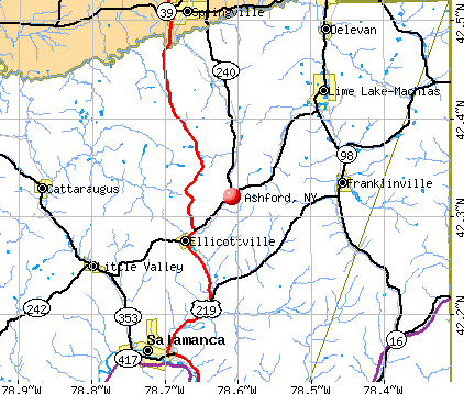
- OSM Map
- General Map
- Google Map
- MSN Map
Population change since 2000: -4.1%
 |
| Males: 1,099 | |
| Females: 1,033 |
| Median resident age: | 45.0 years |
| New York median age: | 40.7 years |
Zip codes: 14171.
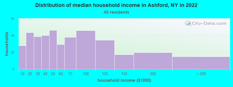
| Ashford: | $62,467 |
| NY: | $79,557 |
Estimated per capita income in 2022: $35,889 (it was $19,136 in 2000)
Ashford town income, earnings, and wages data
Estimated median house or condo value in 2022: $129,832 (it was $70,600 in 2000)
| Ashford: | $129,832 |
| NY: | $400,400 |
Mean prices in 2022: all housing units: $146,086; detached houses: $161,917; townhouses or other attached units: $256,277; in 2-unit structures: $129,405; in 3-to-4-unit structures: $161,674; in 5-or-more-unit structures: $139,490; mobile homes: $56,988; occupied boats, rvs, vans, etc.: $97,187
Detailed information about poverty and poor residents in Ashford, NY


- 2,07497.3%White alone
- 231.1%Black alone
- 160.8%Hispanic
- 90.4%Two or more races
- 70.3%American Indian alone
- 30.1%Asian alone
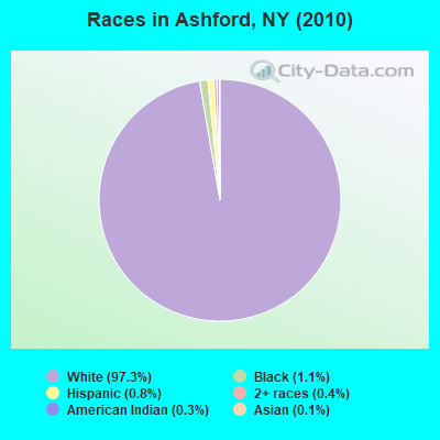
Races in Ashford detailed stats: ancestries, foreign born residents, place of birth
 Recent articles from our blog. Our writers, many of them Ph.D. graduates or candidates, create easy-to-read articles on a wide variety of topics.


Latest news from Ashford, NY collected exclusively by city-data.com from local newspapers, TV, and radio stations
Ancestries: German (39.8%), Irish (16.6%), English (14.3%), Polish (12.4%), United States (4.3%), Italian (4.2%).
Current Local Time: EST time zone
Land area: 51.3 square miles.
Population density: 42 people per square mile (very low).
31 residents are foreign born
| This town: | 1.4% |
| New York: | 20.4% |
| Ashford town: | 2.5% ($1,731) |
| New York: | 1.9% ($2,847) |
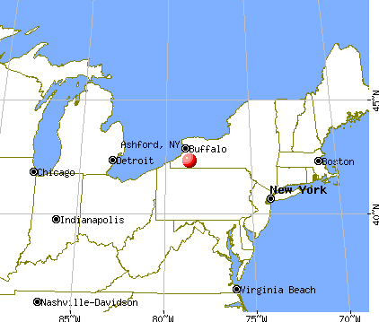
Nearest city with pop. 50,000+: Cheektowaga, NY  (32.6 miles , pop. 79,988).
Nearest city with pop. 200,000+: Buffalo, NY (33.2 miles , pop. 292,648).
Nearest city with pop. 1,000,000+: Philadelphia, PA (248.9 miles , pop. 1,517,550).
Nearest cities:
), ), ), Latitude: 42.45 N, Longitude: 78.65 W
Area code commonly used in this area: 716

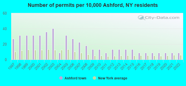
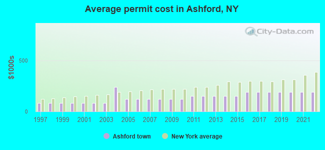
Single-family new house construction building permits:
- 2022: 2 buildings, average cost: $187,500
- 2021: 2 buildings, average cost: $187,500
- 2020: 2 buildings, average cost: $187,500
- 2019: 2 buildings, average cost: $187,500
- 2018: 2 buildings, average cost: $187,500
- 2017: 2 buildings, average cost: $187,500
- 2016: 2 buildings, average cost: $187,500
- 2015: 3 buildings, average cost: $152,300
- 2014: 3 buildings, average cost: $152,300
- 2013: 3 buildings, average cost: $152,300
- 2012: 3 buildings, average cost: $152,300
- 2011: 2 buildings, average cost: $152,300
- 2010: 3 buildings, average cost: $119,800
- 2009: 3 buildings, average cost: $119,800
- 2008: 4 buildings, average cost: $119,800
- 2007: 5 buildings, average cost: $119,800
- 2006: 6 buildings, average cost: $119,800
- 2005: 7 buildings, average cost: $119,800
- 2004: 2 buildings, average cost: $237,500
- 2003: 9 buildings, average cost: $85,100
- 2002: 8 buildings, average cost: $85,100
- 2001: 7 buildings, average cost: $85,100
- 2000: 7 buildings, average cost: $85,100
- 1999: 7 buildings, average cost: $85,100
- 1998: 7 buildings, average cost: $85,100
- 1997: 6 buildings, average cost: $85,100
| Here: | 4.9% |
| New York: | 4.4% |
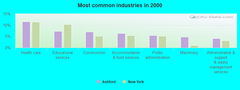
- Health care (11.5%)
- Educational services (7.4%)
- Construction (7.0%)
- Accommodation & food services (6.4%)
- Public administration (5.4%)
- Machinery (4.8%)
- Administrative & support & waste management services (4.2%)
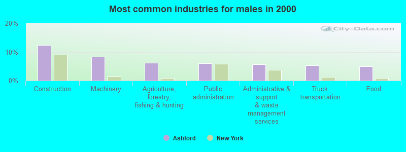
- Construction (12.3%)
- Machinery (8.4%)
- Agriculture, forestry, fishing & hunting (6.2%)
- Public administration (6.1%)
- Administrative & support & waste management services (5.7%)
- Truck transportation (5.4%)
- Food (5.0%)
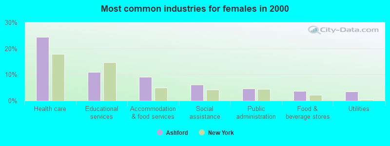
- Health care (24.4%)
- Educational services (11.0%)
- Accommodation & food services (9.2%)
- Social assistance (6.2%)
- Public administration (4.6%)
- Food & beverage stores (3.8%)
- Utilities (3.6%)
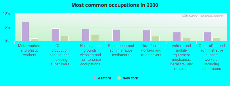
- Metal workers and plastic workers (6.9%)
- Other production occupations, including supervisors (4.5%)
- Building and grounds cleaning and maintenance occupations (4.4%)
- Secretaries and administrative assistants (4.2%)
- Driver/sales workers and truck drivers (3.9%)
- Vehicle and mobile equipment mechanics, installers, and repairers (3.2%)
- Other office and administrative support workers, including supervisors (3.2%)
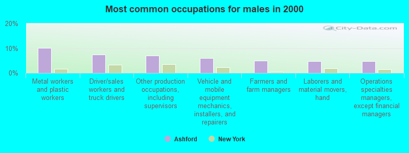
- Metal workers and plastic workers (10.2%)
- Driver/sales workers and truck drivers (7.3%)
- Other production occupations, including supervisors (7.0%)
- Vehicle and mobile equipment mechanics, installers, and repairers (6.1%)
- Farmers and farm managers (5.0%)
- Laborers and material movers, hand (4.8%)
- Operations specialties managers, except financial managers (4.6%)

- Secretaries and administrative assistants (9.0%)
- Nursing, psychiatric, and home health aides (6.8%)
- Other sales and related occupations, including supervisors (5.2%)
- Other teachers, instructors, education, training, and library occupations (5.0%)
- Building and grounds cleaning and maintenance occupations (4.6%)
- Other office and administrative support workers, including supervisors (4.2%)
- Cooks and food preparation workers (4.0%)
Average climate in Ashford, New York
Based on data reported by over 4,000 weather stations


Tornado activity:
Ashford-area historical tornado activity is near New York state average. It is 59% smaller than the overall U.S. average.
On 7/24/1967, a category F3 (max. wind speeds 158-206 mph) tornado 2.0 miles away from the Ashford town center caused between $5000 and $50,000 in damages.
On 8/19/1970, a category F3 tornado 17.7 miles away from the town center injured 3 people and caused between $50,000 and $500,000 in damages.
Earthquake activity:
Ashford-area historical earthquake activity is significantly above New York state average. It is 66% smaller than the overall U.S. average.On 9/25/1998 at 19:52:52, a magnitude 5.2 (4.8 MB, 4.3 MS, 5.2 LG, 4.5 MW, Depth: 3.1 mi, Class: Moderate, Intensity: VI - VII) earthquake occurred 111.4 miles away from the city center
On 1/31/1986 at 16:46:43, a magnitude 5.0 (5.0 MB) earthquake occurred 141.4 miles away from Ashford center
On 8/23/2011 at 17:51:04, a magnitude 5.8 (5.8 MW, Depth: 3.7 mi) earthquake occurred 316.1 miles away from the city center
On 10/7/1983 at 10:18:46, a magnitude 5.3 (5.1 MB, 5.3 LG, 5.1 ML) earthquake occurred 241.0 miles away from Ashford center
On 4/20/2002 at 10:50:47, a magnitude 5.3 (5.3 ML, Depth: 3.0 mi) earthquake occurred 286.8 miles away from the city center
On 4/20/2002 at 10:50:47, a magnitude 5.2 (5.2 MB, 4.2 MS, 5.2 MW, 5.0 MW) earthquake occurred 285.0 miles away from Ashford center
Magnitude types: regional Lg-wave magnitude (LG), body-wave magnitude (MB), local magnitude (ML), surface-wave magnitude (MS), moment magnitude (MW)
Natural disasters:
The number of natural disasters in Cattaraugus County (23) is greater than the US average (15).Major Disasters (Presidential) Declared: 14
Emergencies Declared: 9
Causes of natural disasters: Storms: 11, Floods: 10, Snowstorms: 4, Hurricanes: 2, Winter Storms: 2, Blizzard: 1, Ice Storm: 1, Power Outage: 1, Snow: 1, Tornado: 1, Tropical Storm: 1, Other: 2 (Note: some incidents may be assigned to more than one category).
Hospitals and medical centers near Ashford:
- BERTRAND CHAFFEE HOSPITAL Acute Care Hospitals (about 5 miles away; SPRINGVILLE, NY)
- FIDDLERS GREEN MANOR NURSING HOME (Nursing Home, about 5 miles away; SPRINGVILLE, NY)
- GOWANDA REHABILITATION AND NURSING CENTER (Nursing Home, about 15 miles away; GOWANDA, NY)
- TLC HEALTH NETWORK Acute Care Hospitals (about 15 miles away; GOWANDA, NY)
Colleges/universities with over 2000 students nearest to Ashford:
- Bryant & Stratton College-Online (about 25 miles; Orchard Park, NY; Full-time enrollment: 2,212)
- St Bonaventure University (about 28 miles; Saint Bonaventure, NY; FT enrollment: 2,286)
- Erie Community College (about 33 miles; Buffalo, NY; FT enrollment: 11,035)
- D'Youville College (about 34 miles; Buffalo, NY; FT enrollment: 2,398)
- Canisius College (about 35 miles; Buffalo, NY; FT enrollment: 4,376)
- SUNY at Fredonia (about 35 miles; Fredonia, NY; FT enrollment: 5,523)
- Medaille College (about 35 miles; Buffalo, NY; FT enrollment: 2,361)
Points of interest:
Notable locations in Ashford: Beaver Siding (A), Fox Valley Greenhouse (B), Thomas Corners (C), Western New York Nuclear Service Center (D), Edies Siding (E), Bellow Corners (F), Riceville Station (G), West Valley Fire Department (H). Display/hide their locations on the map
Churches in Ashford include: Riceville Community Church (A), Saint John's Church (B), Saint Paul's United Methodist Church (C), Trinity Church (D). Display/hide their locations on the map
Cemeteries: Saint Johns Cemetery (1), Schwartz Cemetery (2), Franktown Cemetery (3), Weber Cemetery (4), Ashford Hollow Cemetery (5), Riceville Cemetery (6), Thomas Corners Cemetery (7). Display/hide their locations on the map
Creeks: Buttermilk Creek (A), Gooseneck Creek (B), Otis Creek (C), Lagoon Road Creek (D), Indian Creek (E), Franks Creek (F). Display/hide their locations on the map
| This town: | 2.4 people |
| New York: | 2.6 people |
| This town: | 70.1% |
| Whole state: | 63.5% |
| This town: | 7.9% |
| Whole state: | 6.8% |
Likely homosexual households (counted as self-reported same-sex unmarried-partner households)
- Lesbian couples: 0.5% of all households
- Gay men: 0.1% of all households
| This town: | 6.3% |
| Whole state: | 14.6% |
| This town: | 2.8% |
| Whole state: | 7.4% |
For population 15 years and over in Ashford:
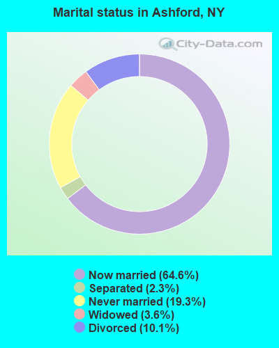
- Never married: 19.3%
- Now married: 64.6%
- Separated: 2.3%
- Widowed: 3.6%
- Divorced: 10.1%
For population 25 years and over in Ashford:
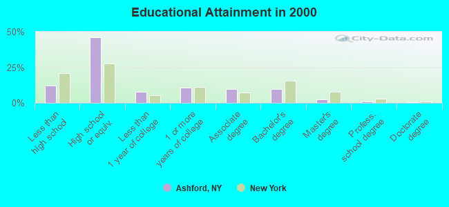
- High school or higher: 87.7%
- Bachelor's degree or higher: 13.5%
- Graduate or professional degree: 4.0%
- Unemployed: 5.7%
- Mean travel time to work (commute): 27.9 minutes
| Here: | 8.7 |
| New York average: | 14.2 |
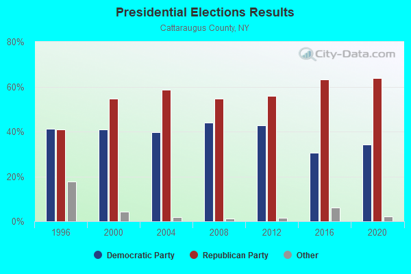
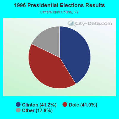
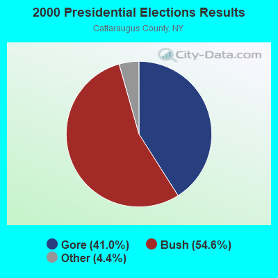
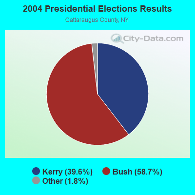
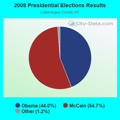

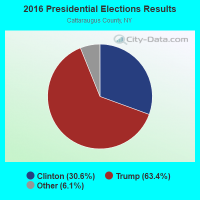
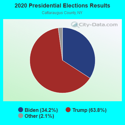
Graphs represent county-level data. Detailed 2008 Election Results
Religion statistics for Ashford, NY (based on Cattaraugus County data)
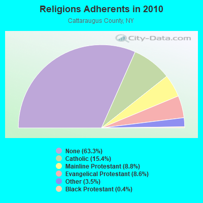
| Religion | Adherents | Congregations |
|---|---|---|
| Catholic | 12,351 | 12 |
| Mainline Protestant | 7,090 | 49 |
| Evangelical Protestant | 6,923 | 71 |
| Other | 2,843 | 12 |
| Black Protestant | 305 | 2 |
| None | 50,805 | - |
Food Environment Statistics:
| This county: | 2.62 / 10,000 pop. |
| State: | 4.13 / 10,000 pop. |
| Here: | 0.12 / 10,000 pop. |
| State: | 0.06 / 10,000 pop. |
| Here: | 1.12 / 10,000 pop. |
| State: | 0.92 / 10,000 pop. |
| Cattaraugus County: | 3.87 / 10,000 pop. |
| State: | 1.68 / 10,000 pop. |
| Here: | 9.48 / 10,000 pop. |
| New York: | 8.82 / 10,000 pop. |
| Here: | 9.5% |
| New York: | 8.2% |
| Here: | 28.5% |
| New York: | 23.8% |
| This county: | 16.7% |
| State: | 15.6% |
Strongest AM radio stations in Ashford:
- WWKB (1520 AM; 50 kW; BUFFALO, NY; Owner: ENTERCOM BUFFALO LICENSE, LLC)
- WSPQ (1330 AM; 1 kW; SPRINGVILLE, NY; Owner: HAWK COMMUNICATIONS, LTD.)
- WGR (550 AM; 5 kW; BUFFALO, NY; Owner: ENTERCOM BUFFALO LICENSE, LLC)
- WHAM (1180 AM; 50 kW; ROCHESTER, NY; Owner: CITICASTERS LICENSES, L.P.)
- WNED (970 AM; 5 kW; BUFFALO, NY)
- WGGO (1590 AM; 5 kW; SALAMANCA, NY; Owner: CATT COMMUNICATIONS, INC.)
- WHLD (1270 AM; 5 kW; NIAGARA FALLS, NY; Owner: CITADEL BROADCASTING COMPANY)
- WXRL (1300 AM; 5 kW; LANCASTER, NY; Owner: DOME BROADCASTING, INC.)
- WTOR (770 AM; daytime; 9 kW; YOUNGSTOWN, NY; Owner: BIRACH BROADCASTING CORPORATION)
- WBEN (930 AM; 5 kW; BUFFALO, NY; Owner: ENTERCOM BUFFALO LICENSE, LLC)
- KDKA (1020 AM; 50 kW; PITTSBURGH, PA; Owner: INFINITY BROADCASTING OPERATIONS, INC.)
- WCJW (1140 AM; daytime; 2 kW; WARSAW, NY; Owner: LLOYD LANE, INCORPORATED)
- WKNR (850 AM; 50 kW; CLEVELAND, OH; Owner: CARON BROADCASTING, INC.)
Strongest FM radio stations in Ashford:
- WTSS (102.5 FM; BUFFALO, NY; Owner: ENTERCOM BUFFALO LICENSE, LLC)
- WNED-FM (94.5 FM; BUFFALO, NY; Owner: WESTERN NEW YORK PUBLIC B/C ASSOC.)
- WBUF (92.9 FM; BUFFALO, NY; Owner: INFINITY RADIO OPERATIONS INC.)
- WDCX (99.5 FM; BUFFALO, NY; Owner: KIMTRON, INC.)
- WNSA (107.7 FM; WETHERSFIELD TWNSHP, NY; Owner: ADELPHIA COMMUNICATIONS CORPORATION, DEBTOR-IN-POSSESSION)
- WFBF (89.9 FM; BUFFALO, NY; Owner: FAMILY STATIONS, INC.)
- WQRT (98.3 FM; SALAMANCA, NY; Owner: CATT COMMUNICATIONS, INC.)
- WPIG (95.7 FM; OLEAN, NY; Owner: ARROW COMMUNICATIONS OF N.Y., INC.)
- WGRF (96.9 FM; BUFFALO, NY; Owner: CITADEL BROADCASTING COMPANY)
- WOLN (91.3 FM; OLEAN, NY; Owner: STATE UNIVERSITY OF NEW YORK)
- WNJA (89.7 FM; JAMESTOWN, NY; Owner: WESTERN NEW YORK PUBLIC B/CING ASSOC)
- WMXO (101.5 FM; OLEAN, NY; Owner: VOX ALLEGANY, LLC)
- W213BC (90.5 FM; OLEAN, NY; Owner: FAMILY LIFE MINISTRIES, INC.)
- WHTT-FM (104.1 FM; BUFFALO, NY; Owner: CITADEL BROADCASTING COMPANY)
TV broadcast stations around Ashford:
- WNGS (Channel 67; SPRINGVILLE, NY; Owner: CAROLINE K. POWLEY D/B/A UNICORN/SPRINGVILLE)
- WKBW-TV (Channel 7; BUFFALO, NY; Owner: WKBW-TV LICENSE, INC.)
- WIVB-TV (Channel 4; BUFFALO, NY; Owner: WIVB BROADCASTING, LLC)
- WGRZ-TV (Channel 2; BUFFALO, NY; Owner: MULTIMEDIA ENTERTAINMENT, INC.)
- WNYO-TV (Channel 49; BUFFALO, NY; Owner: NEW YORK TELEVISION, INC.)
- WNYB (Channel 26; JAMESTOWN, NY; Owner: FAITH BROADCASTING NETWORK, INC.)
- WNED-TV (Channel 17; BUFFALO, NY; Owner: WESTERN NY PUBLIC BROADCASTING ASSOC.)
- WUTV (Channel 29; BUFFALO, NY; Owner: WUTV LICENSEE, LLC)
- WNLO (Channel 23; BUFFALO, NY; Owner: WIVB BROADCASTING, LLC)
- WDTB-LP (Channel 39; HAMBURG, NY; Owner: WORD OF GOD FELLOWSHIP, INC.)
- WFHW-LP (Channel 58; BUFFALO, NY; Owner: CITIZENS TELEVISION SYSTEM, INC.)
- WBXZ-LP (Channel 56; BUFFALO, NY; Owner: RENARD COMMUNICATIONS CORP.)
- National Bridge Inventory (NBI) Statistics
- 24Number of bridges
- 361ft / 110mTotal length
- $92,570,000Total costs
- 32,783Total average daily traffic
- 3,966Total average daily truck traffic
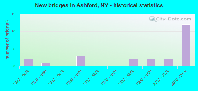
- New bridges - historical statistics
- 21920-1929
- 11930-1939
- 31950-1959
- 21980-1989
- 21990-1999
- 22000-2009
- 122010-2019
FCC Registered Cell Phone Towers:
2 (See the full list of FCC Registered Cell Phone Towers in Ashford)FCC Registered Antenna Towers:
32 (See the full list of FCC Registered Antenna Towers)FCC Registered Broadcast Land Mobile Towers:
3- 7129 Henrietta Rd. (085052) (Lat: 42.472028 Lon: -78.709500), Type: Gtower, Structure height: 86.6 m, Overall height: 88.1 m, Call Sign: KNID397,
Assigned Frequencies: 424.287 MHz, 460.200 MHz, Grant Date: 07/10/2015, Expiration Date: 09/10/2025, Registrant: Apco International Inc, 351 N Williamson Blvd, Daytona Beach, FL 32114, Phone: (386) 944-2469, Fax: (386) 322-2502, Email:
- 7129 Henrietta Rd. (085052) (Lat: 42.472028 Lon: -78.709500), Type: Gtower, Structure height: 86.2 m, Overall height: 88.1 m, Call Sign: WQYH294,
Assigned Frequencies: 463.112 MHz, 463.087 MHz, 462.962 MHz, 463.100 MHz, Grant Date: 09/27/2016, Expiration Date: 09/27/2026, Certifier: Kevin C Hughes, Registrant: Saia Communications Inc, 100 Stradtman St, Buffalo, NY 14206, Phone: (716) 892-2900, Fax: (716) 892-2983, Email:
- EAST OTTO, 7129 Henrietta Rd. (085052) (Lat: 42.472028 Lon: -78.709500), Type: Gtower, Structure height: 86.2 m, Overall height: 88.1 m, Call Sign: WQZG448,
Assigned Frequencies: 453.462 MHz, 453.212 MHz, 453.212 MHz, 453.462 MHz, 151.137 MHz, 151.137 MHz, 159.472 MHz, 159.472 MHz, Grant Date: 05/09/2017, Expiration Date: 05/09/2027, Certifier: Kevin C Hughes, Registrant: Saia Communications, 100 Stradtman St, Buffalo, NY 14206, Phone: (716) 892-2900, Fax: (716) 892-2983, Email:
FCC Registered Microwave Towers:
7- STATION, Borden Ave (Lat: 42.258944 Lon: -78.643639), Overall height: 6.1 m, Call Sign: WNEU824,
Assigned Frequencies: 952.387 MHz, Grant Date: 10/10/2018, Expiration Date: 11/26/2028, Certifier: Chris Kelly, Registrant: National Grid Usa Service Company Inc, 300 Erie Boulevard West, Syracuse, NY 13202, Phone: (781) 907-3409, Fax: (781) 907-5715, Email:
- WST1002A, 7129 Henrietta Rd. (085052) (Lat: 42.472028 Lon: -78.709500), Type: Tower, Structure height: 86.2 m, Overall height: 88.1 m, Call Sign: WQFB458,
Assigned Frequencies: 6810.62 MHz, Grant Date: 03/12/2016, Expiration Date: 06/07/2026, Certifier: Thomas J Cowper, Registrant: Nys Div. Of Homeland Security And Emergency Services, 1220 Washington Ave, Bldg. 7a, Ste 710, State Office Campus, Albany, NY 12242, Phone: (518) 322-4912, Fax: (518) 322-4975, Email:
- ROHR HILL, Rohr Hill Rd. (Lat: 42.382194 Lon: -78.675111), Type: Tower, Structure height: 106.7 m, Overall height: 109.7 m, Call Sign: WQPA445,
Assigned Frequencies: 5945.20 MHz, Grant Date: 03/20/2012, Expiration Date: 03/20/2022, Cancellation Date: 08/25/2014, Certifier: Pamelia Y Hoof, Registrant: Verizon Wireless, 1120 Sanctuary Pkwy, #150 Gasa5reg, Alpharetta, GA 30009-7630, Phone: (770) 797-1070, Fax: (770) 797-1036, Email:
- BU33HO314, Rohr Hill Rd. (Lat: 42.382194 Lon: -78.675111), Type: Ltower, Structure height: 106.7 m, Overall height: 109.7 m, Call Sign: WQSH669,
Assigned Frequencies: 11385.0 MHz, 11265.0 MHz, Grant Date: 09/20/2013, Expiration Date: 09/20/2023, Cancellation Date: 05/01/2023, Certifier: David Werblow, Registrant: T-Mobile Usa, Inc., 12920 Se 38th Street, Bellevue, WA 98006, Phone: (425) 383-8401, Email:
- BU33HO315, 7129 Henrietta Rd (Lat: 42.471944 Lon: -78.709444), Type: Gtower, Structure height: 86.2 m, Overall height: 88.7 m, Call Sign: WQSH670,
Assigned Frequencies: 10895.0 MHz, Grant Date: 09/20/2013, Expiration Date: 09/20/2023, Cancellation Date: 05/08/2023, Certifier: David Werblow, Registrant: T-Mobile Usa, Inc., 12920 Se 38th Street, Bellevue, WA 98006, Phone: (425) 383-8401, Email:
- SPRINGVILLES, 7129 Henrietta Rd. (085052) (Lat: 42.472028 Lon: -78.709500), Type: Gtower, Structure height: 86.2 m, Overall height: 88.1 m, Call Sign: WQUR380,
Assigned Frequencies: 11035.0 MHz, Grant Date: 09/17/2014, Expiration Date: 09/17/2024, Cancellation Date: 10/25/2023, Certifier: Chris Harris, Registrant: Conterra Ultra Broadband, LLC, 5301 77 Center Drive, Charlotte, NC 28217, Phone: (704) 936-1777, Fax: (704) 936-1801, Email:
- 3CSO909A, Rohr Hill Rd. (Lat: 42.382194 Lon: -78.675111), Type: Upole, Structure height: 106.7 m, Overall height: 109.7 m, Call Sign: WQWN722,
Assigned Frequencies: 10975.0 MHz, 10975.0 MHz, 10975.0 MHz, 10975.0 MHz, 10975.0 MHz, 10975.0 MHz, 10975.0 MHz, 10975.0 MHz, Grant Date: 10/14/2015, Expiration Date: 10/14/2025, Certifier: David Werblow, Registrant: T-Mobile License LLC, 12920 Se 38th St, Bellevue, WA 98006, Phone: (425) 383-8401, Fax: (425) 383-4840, Email:
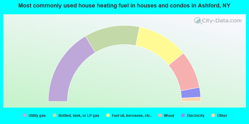
- 32.9%Utility gas
- 23.5%Bottled, tank, or LP gas
- 21.8%Fuel oil, kerosene, etc.
- 16.0%Wood
- 4.1%Electricity
- 1.2%Coal or coke
- 0.5%Other fuel
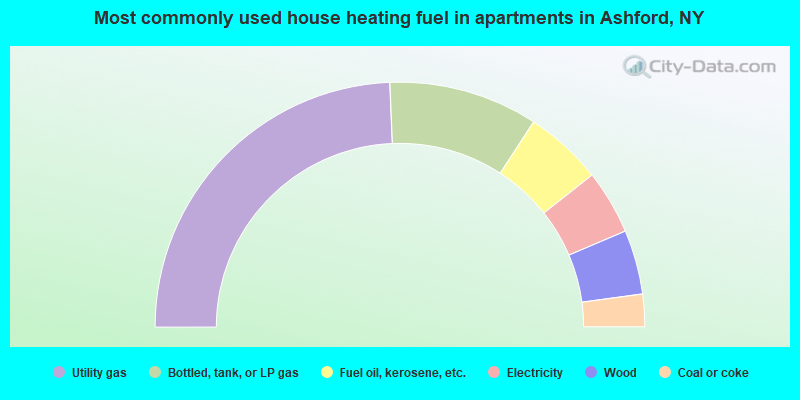
- 48.7%Utility gas
- 19.7%Bottled, tank, or LP gas
- 10.3%Fuel oil, kerosene, etc.
- 8.5%Electricity
- 8.5%Wood
- 4.3%Coal or coke
Ashford compared to New York state average:
- Median house value significantly below state average.
- Unemployed percentage below state average.
- Black race population percentage significantly below state average.
- Hispanic race population percentage significantly below state average.
- Median age above state average.
- Foreign-born population percentage significantly below state average.
- Renting percentage significantly below state average.
- Length of stay since moving in significantly above state average.
- Number of rooms per house significantly below state average.
- House age significantly below state average.
- Number of college students below state average.
- Percentage of population with a bachelor's degree or higher below state average.