Ashland, Mississippi
Submit your own pictures of this town and show them to the world
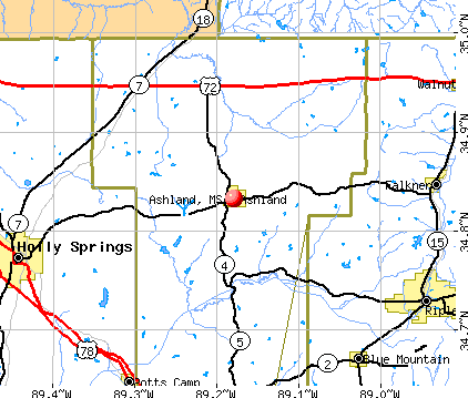
- OSM Map
- General Map
- Google Map
- MSN Map
Population change since 2000: -6.8%
 |
| Males: 264 | |
| Females: 274 |
| Median resident age: | 44.3 years |
| Mississippi median age: | 38.9 years |
Zip codes: 38603.
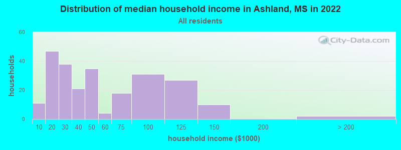
| Ashland: | $39,977 |
| MS: | $52,719 |
Estimated per capita income in 2022: $22,334 (it was $14,073 in 2000)
Ashland town income, earnings, and wages data
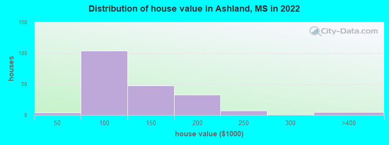
Estimated median house or condo value in 2022: $105,033 (it was $54,000 in 2000)
| Ashland: | $105,033 |
| MS: | $162,500 |
Mean prices in 2022: all housing units: $179,009; detached houses: $179,536; townhouses or other attached units: $159,512
Median gross rent in 2022: $797.
(24.5% for White Non-Hispanic residents, 16.9% for Black residents, 76.9% for two or more races residents)
Detailed information about poverty and poor residents in Ashland, MS
Compare current foreclosures near Ashland, MS:
| Photo | Address | Area | Beds / Baths | Price | Details |
|---|---|---|---|---|---|

|
#1
Red Oak Rd
Ashland, MS 38603
|
- sq. feet
|
- baths - beds |
show details | |

|
#2
Lakeview Dr
Ashland, MS 38603
|
959 sq. feet
|
- baths - beds |
show details | |

|
#3
Shady Ln
Ashland, MS 38603
|
- sq. feet
|
- baths - beds |
show details | |

|
#4
2nd St
Ashland, MS 38603
|
- sq. feet
|
- baths - beds |
show details | |

|
#5
Snow Lake Dr
Ashland, MS 38603
|
- sq. feet
|
- baths - beds |
show details | |

|
#6
Lake Shore Dr
Potts Camp, MS 38659
|
1,443 sq. feet
|
2 baths 2 beds |
$69,900
|
show details |

|
#7
Elm St
Ripley, MS 38663
|
941 sq. feet
|
1 baths 3 beds |
$86,900
|
show details |

|
#8
Breedlove Rd
Michigan City, MS 38647
|
2,370 sq. feet
|
3 baths 4 beds |
show details | |

|
#9
S Commerce St
Ripley, MS 38663
|
- sq. feet
|
2 baths 3 beds |
show details | |

|
#10
Sexton Rd
Lamar, MS 38642
|
1,860 sq. feet
|
1 baths 3 beds |
show details |
| Photo | Address | Area | Beds / Baths | Price | Details |
|---|---|---|---|---|---|

|
#11
Jennifer Rd
Holly Springs, MS 38635
|
984 sq. feet
|
1 baths - beds |
show details | |

|
#12
E Walnut St
Ripley, MS 38663
|
2,280 sq. feet
|
1 baths - beds |
show details | |

|
#13
W Mill St
Blue Mountain, MS 38610
|
1,923 sq. feet
|
1 baths - beds |
show details | |

|
#14
Mary Ellen Dr
Ripley, MS 38663
|
1,656 sq. feet
|
1 baths - beds |
show details | |

|
#15
Hoover Rd
Holly Springs, MS 38635
|
1,740 sq. feet
|
1 baths - beds |
show details | |

|
#16
Saulsbury Rd
Saulsbury, TN 38067
|
1,260 sq. feet
|
1 baths - beds |
show details | |

|
#17
Highway 57 E
Grand Junction, TN 38039
|
1,232 sq. feet
|
1 baths - beds |
show details | |

|
#18
W Lake Dr
Holly Springs, MS 38635
|
900 sq. feet
|
1 baths - beds |
show details | |

|
#19
County Road 808
Ripley, MS 38663
|
1,152 sq. feet
|
1 baths - beds |
show details | |

|
#20
Ventura Cv
Holly Springs, MS 38635
|
1,240 sq. feet
|
1 baths - beds |
show details |
| Photo | Address | Area | Beds / Baths | Price | Details |
|---|---|---|---|---|---|

|
#21
Park Swain Rd
Grand Junction, TN 38039
|
1,478 sq. feet
|
3 baths - beds |
show details | |

|
#22
Windham Ln
Ripley, MS 38663
|
2,189 sq. feet
|
1 baths - beds |
show details | |

|
#23
Highland Ter
Holly Springs, MS 38635
|
2,229 sq. feet
|
1 baths - beds |
show details | |

|
#24
W Main St
Blue Mountain, MS 38610
|
2,637 sq. feet
|
1 baths - beds |
show details | |

|
#25
Flora Cir
Holly Springs, MS 38635
|
1,056 sq. feet
|
1 baths - beds |
show details | |

|
#26
Park Swain Rd
Grand Junction, TN 38039
|
1,158 sq. feet
|
1 baths - beds |
show details | |

|
#27
Rawls Rd
Grand Junction, TN 38039
|
1,109 sq. feet
|
1 baths - beds |
show details | |

|
#28
Highway 349 S
Potts Camp, MS 38659
|
1,222 sq. feet
|
1 baths - beds |
show details | |

|
#29
West St
Holly Springs, MS 38635
|
1,140 sq. feet
|
1 baths - beds |
show details | |

|
#30
W 1st St
Ripley, MS 38663
|
1,201 sq. feet
|
1 baths - beds |
show details |
| Photo | Address | Area | Beds / Baths | Price | Details |
|---|---|---|---|---|---|

|
#31
Lamar Rd
Lamar, MS 38642
|
1,438 sq. feet
|
1 baths - beds |
show details | |

|
#32
Rolfing Rd
Holly Springs, MS 38635
|
1,222 sq. feet
|
1 baths - beds |
show details | |

|
#33
E Pontotoc Ave
Potts Camp, MS 38659
|
1,512 sq. feet
|
1 baths - beds |
show details | |

|
#34
County Road 501
Ripley, MS 38663
|
960 sq. feet
|
- baths 2 beds |
show details | |

|
#35
West St
Holly Springs, MS 38635
|
1,458 sq. feet
|
1 baths - beds |
show details | |

|
#36
Highway 72
Walnut, MS 38683
|
- sq. feet
|
- baths - beds |
show details | |

|
#37
County Road 300
Tiplersville, MS 38674
|
925 sq. feet
|
- baths - beds |
show details | |

|
#38
Withers Ave
Holly Springs, MS 38635
|
- sq. feet
|
- baths - beds |
show details | |

|
#39
Stratmon Dr
Holly Springs, MS 38635
|
- sq. feet
|
- baths - beds |
show details | |

|
#40
Cheairs Ln
Grand Junction, TN 38039
|
2,016 sq. feet
|
- baths - beds |
show details |
| Photo | Address | Area | Beds / Baths | Price | Details |
|---|---|---|---|---|---|

|
#41
E Walnut St
Ripley, MS 38663
|
- sq. feet
|
- baths - beds |
show details | |

|
#42
E Valley Ave
Holly Springs, MS 38635
|
1,521 sq. feet
|
- baths - beds |
show details | |

|
#43
S Chesterman St Apt 1a
Holly Springs, MS 38635
|
- sq. feet
|
- baths - beds |
show details | |

|
#44
Fletcher Ln
Grand Junction, TN 38039
|
- sq. feet
|
- baths - beds |
show details | |

|
#45
School St
Ripley, MS 38663
|
- sq. feet
|
- baths - beds |
show details | |

|
#46
S Chesterman St Apt 2e
Holly Springs, MS 38635
|
- sq. feet
|
- baths - beds |
show details | |

|
#47
Zinna Ln
Grand Junction, TN 38039
|
1,680 sq. feet
|
- baths - beds |
show details | |

|
#48
E Park Ave
Holly Springs, MS 38635
|
- sq. feet
|
- baths - beds |
show details | |

|
#49
Old Highway 4 W
Holly Springs, MS 38635
|
- sq. feet
|
- baths - beds |
show details | |

|
Check over 1 million property listings on Foreclosure.com!
|
browse all offers | |||


- 53981.9%White alone
- 8512.9%Black alone
- 406.1%Two or more races
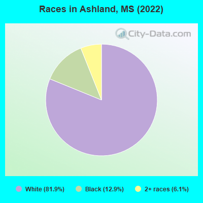
Races in Ashland detailed stats: ancestries, foreign born residents, place of birth
According to our research of Mississippi and other state lists, there were 12 registered sex offenders living in Ashland, Mississippi as of April 28, 2024.
The ratio of all residents to sex offenders in Ashland is 45 to 1.
 Recent articles from our blog. Our writers, many of them Ph.D. graduates or candidates, create easy-to-read articles on a wide variety of topics.

 | Jackson among nation's fattest metros (10 replies) |
| Mississippi SCORES! (0 replies) |
| Hickory Flat, MS 38633 ?? (4 replies) |
| Teaching in teacher shortage areas. (6 replies) |
| Horn lake, Southaven, or Olive branch? (14 replies) |
| Potts Camp,ms? (2 replies) |
Latest news from Ashland, MS collected exclusively by city-data.com from local newspapers, TV, and radio stations
Ancestries: English (26.1%), American (13.6%), Irish (6.8%), German (3.3%), Scotch-Irish (3.0%), Italian (2.2%).
Current Local Time: CST time zone
Incorporated on 03/08/1873
Land area: 1.83 square miles.
Population density: 295 people per square mile (very low).
Median real estate property taxes paid for housing units with mortgages in 2022: $738 (0.8%)
Median real estate property taxes paid for housing units with no mortgage in 2022: $627 (0.5%)
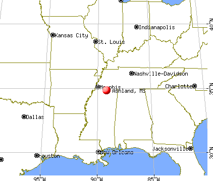
Nearest city with pop. 50,000+: Memphis, TN  (49.0 miles , pop. 650,100).
Nearest city with pop. 1,000,000+: Dallas, TX (459.1 miles , pop. 1,188,580).
Nearest cities:
), ), ), ), ), )Latitude: 34.83 N, Longitude: 89.18 W
Area code: 662
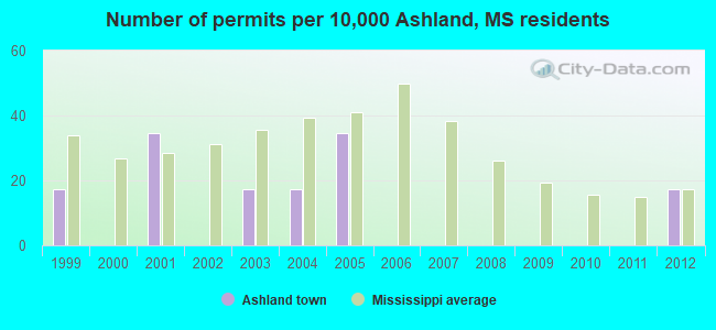
Single-family new house construction building permits:
- 2012: 1 building, cost: $81,300
- 2005: 2 buildings, average cost: $77,500
- 2004: 1 building, cost: $3,000
- 2003: 1 building, cost: $5,000
- 2001: 2 buildings, average cost: $65,000
- 1999: 1 building, cost: $16,000
| Here: | 3.3% |
| Mississippi: | 2.6% |
- Construction (13.2%)
- Health care (8.0%)
- Computer & electronic products (7.5%)
- Public administration (7.1%)
- Truck transportation (4.2%)
- Food & beverage stores (3.8%)
- Religious, grantmaking, civic, professional, similar organizations (3.8%)
- Construction (20.8%)
- Truck transportation (8.9%)
- Public administration (7.9%)
- Agriculture, forestry, fishing & hunting (5.9%)
- Machinery (5.0%)
- Miscellaneous manufacturing (5.0%)
- Gasoline stations (5.0%)
- Health care (15.3%)
- Computer & electronic products (14.4%)
- Construction (6.3%)
- Public administration (6.3%)
- Furniture & related product manufacturing (5.4%)
- Apparel (5.4%)
- Other direct selling establishments (4.5%)
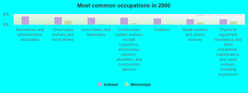
- Secretaries and administrative assistants (6.6%)
- Driver/sales workers and truck drivers (6.1%)
- Assemblers and fabricators (5.7%)
- Construction traders workers except carpenters, electricians, painters, plumbers, and construction laborers (5.7%)
- Cashiers (5.2%)
- Metal workers and plastic workers (4.2%)
- Electrical equipment mechanics and other installation, maintenance, and repair workers, including supervisors (4.2%)
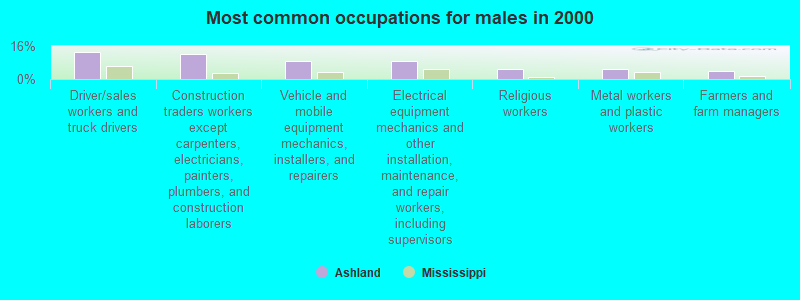
- Driver/sales workers and truck drivers (12.9%)
- Construction traders workers except carpenters, electricians, painters, plumbers, and construction laborers (11.9%)
- Vehicle and mobile equipment mechanics, installers, and repairers (8.9%)
- Electrical equipment mechanics and other installation, maintenance, and repair workers, including supervisors (8.9%)
- Religious workers (5.0%)
- Metal workers and plastic workers (5.0%)
- Farmers and farm managers (4.0%)

- Secretaries and administrative assistants (12.6%)
- Cashiers (9.9%)
- Assemblers and fabricators (8.1%)
- Registered nurses (7.2%)
- Health technologists and technicians (6.3%)
- Retail sales workers, except cashiers (5.4%)
- Textile, apparel, and furnishings workers (5.4%)
Average climate in Ashland, Mississippi
Based on data reported by over 4,000 weather stations


(lower is better)
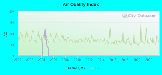
Air Quality Index (AQI) level in 2004 was 82.3. This is about average.
| City: | 82.3 |
| U.S.: | 72.6 |
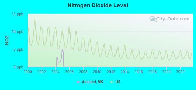
Nitrogen Dioxide (NO2) [ppb] level in 2004 was 2.27. This is significantly better than average. Closest monitor was 16.2 miles away from the city center.
| City: | 2.27 |
| U.S.: | 5.11 |
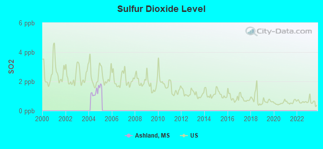
Sulfur Dioxide (SO2) [ppb] level in 2004 was 1.28. This is about average. Closest monitor was 16.2 miles away from the city center.
| City: | 1.28 |
| U.S.: | 1.51 |
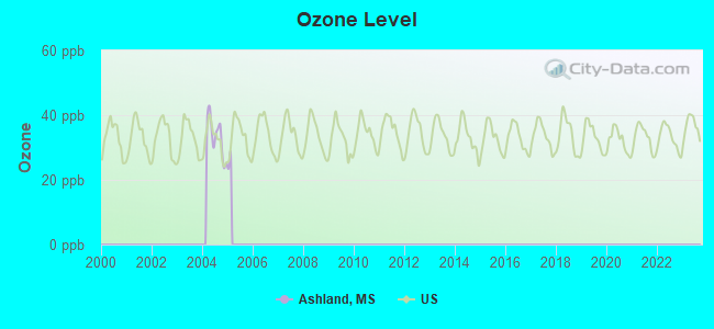
Ozone [ppb] level in 2004 was 33.3. This is about average. Closest monitor was 16.2 miles away from the city center.
| City: | 33.3 |
| U.S.: | 33.3 |
Tornado activity:
Ashland-area historical tornado activity is near Mississippi state average. It is 84% greater than the overall U.S. average.
On 4/19/1970, a category F4 (max. wind speeds 207-260 mph) tornado 12.8 miles away from the Ashland town center killed 4 people and injured 78 people and caused between $500,000 and $5,000,000 in damages.
On 2/21/1971, a category F4 tornado 20.1 miles away from the town center killed 58 people and injured 795 people and caused between $5000 and $50,000 in damages.
Earthquake activity:
Ashland-area historical earthquake activity is significantly above Mississippi state average. It is 311% greater than the overall U.S. average.On 3/25/1976 at 00:41:20, a magnitude 5.0 (4.9 MB, 5.0 LG, Class: Moderate, Intensity: VI - VII) earthquake occurred 85.5 miles away from the city center
On 5/4/1991 at 01:18:54, a magnitude 5.0 (4.4 MB, 4.6 LG, 5.0 LG, Depth: 3.1 mi) earthquake occurred 125.1 miles away from Ashland center
On 4/27/1989 at 16:47:49, a magnitude 4.7 (4.6 MB, 4.7 LG, 4.3 LG, Class: Light, Intensity: IV - V) earthquake occurred 87.7 miles away from the city center
On 9/26/1990 at 13:18:51, a magnitude 5.0 (4.7 MB, 4.8 LG, 5.0 LG, Depth: 7.7 mi) earthquake occurred 162.7 miles away from the city center
On 4/18/2008 at 09:36:59, a magnitude 5.4 (5.1 MB, 4.8 MS, 5.4 MW, 5.2 MW) earthquake occurred 260.4 miles away from Ashland center
On 1/18/1999 at 07:00:53, a magnitude 4.8 (4.8 MB, 4.0 LG, Depth: 0.6 mi) earthquake occurred 147.9 miles away from the city center
Magnitude types: regional Lg-wave magnitude (LG), body-wave magnitude (MB), surface-wave magnitude (MS), moment magnitude (MW)
Natural disasters:
The number of natural disasters in Benton County (10) is smaller than the US average (15).Major Disasters (Presidential) Declared: 8
Emergencies Declared: 1
Causes of natural disasters: Storms: 8, Tornadoes: 7, Floods: 5, Freezes: 2, Winds: 2, Drought: 1, Winter Storm: 1, Other: 1 (Note: some incidents may be assigned to more than one category).

Hospitals and medical centers in Ashland:
Other hospitals and medical centers near Ashland:
- REST HAVEN HEALTH AND REHABILITATION (Nursing Home, about 15 miles away; RIPLEY, MS)
- REST HAVEN NH (Nursing Home, about 15 miles away; RIPLEY, MS)
- GOLDEN LIVINGCENTER - RIPLEY (Nursing Home, about 15 miles away; RIPLEY, MS)
- RIPLEY MANOR NH (Nursing Home, about 15 miles away; RIPLEY, MS)
- HERITAGE MANOR OF HOLLY SPRINGS (Nursing Home, about 15 miles away; HOLLY SPRINGS, MS)
Airports located in Ashland:
- John Farese Airpark Airport (MS14) (Runways: 1)
Colleges/universities with over 2000 students nearest to Ashland:
- Northeast Mississippi Community College (about 37 miles; Booneville, MS; Full-time enrollment: 3,024)
- University of Mississippi (about 39 miles; University, MS; FT enrollment: 17,642)
- Northwest Mississippi Community College (about 48 miles; Senatobia, MS; FT enrollment: 6,607)
- University of Memphis (about 50 miles; Memphis, TN; FT enrollment: 17,427)
- Rhodes College (about 52 miles; Memphis, TN; FT enrollment: 2,052)
- Southwest Tennessee Community College (about 53 miles; Memphis, TN; FT enrollment: 8,043)
- Itawamba Community College (about 59 miles; Fulton, MS; FT enrollment: 5,489)
Public high schools in Ashland:
- ASHLAND HIGH SCHOOL (Location: 101 SCHOOL STREET, Grades: 6-12)
- BENTON CO REGIONAL VOCATIONAL CEN (Location: 25 INDUSTRIAL DRIVE, Grades: 9-12)
Public elementary/middle schools in Ashland:
- ASHLAND ELEMENTARY SCHOOL (Location: 768 LAMAR ROAD, Grades: KG-5)
- ASHLAND MIDDLE SCHOOL (Location: 123 SCHOOL STREET, Grades: 6-8)
Points of interest:
Notable location: Ashland Fire Department (A). Display/hide its location on the map
Churches in Ashland include: Ashland Church of Christ (A), Ashland Baptist Church (B). Display/hide their locations on the map
Cemetery: Ashland Cemetery (1). Display/hide its location on the map
Courts: Benton County - Justice Court Judge Ward (190 Ripley Avenue), Benton County - Circuit Court Room (190 Ripley Avenue), Benton County - Justice Court Judge Mason (190 Ripley Avenue), Benton County - Justice Court Clerk (10 Main Street North).
| This town: | 2.3 people |
| Mississippi: | 2.6 people |
| This town: | 61.1% |
| Whole state: | 69.0% |
| This town: | 5.4% |
| Whole state: | 5.7% |
Likely homosexual households (counted as self-reported same-sex unmarried-partner households)
- Lesbian couples: 0.5% of all households
- Gay men: 0.9% of all households
9 people in local jails and other municipal confinement facilities in 2010
100 people in nursing homes in 2000
16 people in local jails and other confinement facilities (including police lockups) in 2000
Banks with branches in Ashland (2011 data):
- Merchants & Farmers Bank: Ashland Branch at Route 2 And Highway 5, branch established on 1975/09/30. Info updated 2006/11/03: Bank assets: $86.8 mil, Deposits: $76.3 mil, headquarters in Holly Springs, MS, positive income, 5 total offices, Holding Company: M & F Bancorp, Inc.
- Regions Bank: Ashland Branch at 56 Main Street South, branch established on 1967/03/01. Info updated 2011/02/24: Bank assets: $123,368.2 mil, Deposits: $98,301.3 mil, headquarters in Birmingham, AL, positive income, Commercial Lending Specialization, 1778 total offices, Holding Company: Regions Financial Corporation
For population 15 years and over in Ashland:
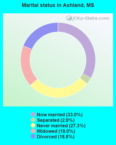
- Never married: 27.3%
- Now married: 33.0%
- Separated: 2.9%
- Widowed: 18.0%
- Divorced: 18.8%
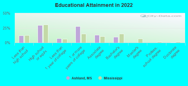
For population 25 years and over in Ashland:
- High school or higher: 85.0%
- Bachelor's degree or higher: 9.6%
- Graduate or professional degree: 0.7%
- Unemployed: 6.6%
- Mean travel time to work (commute): 24.1 minutes

| Here: | 8.3 |
| Mississippi average: | 11.8 |


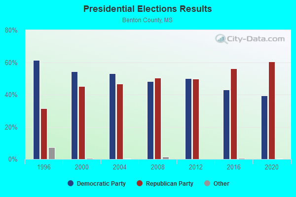
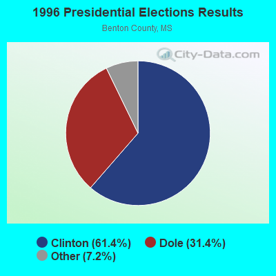
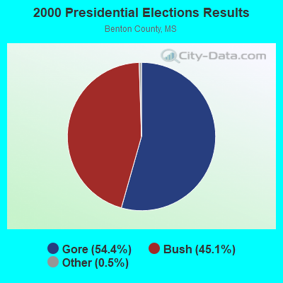
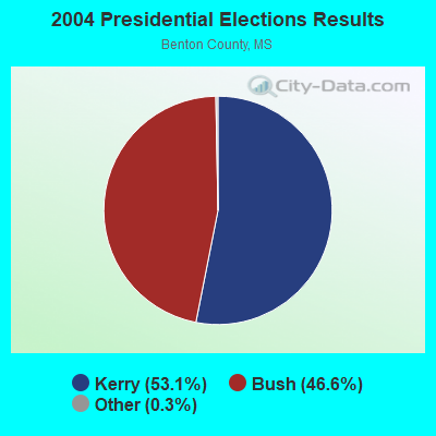
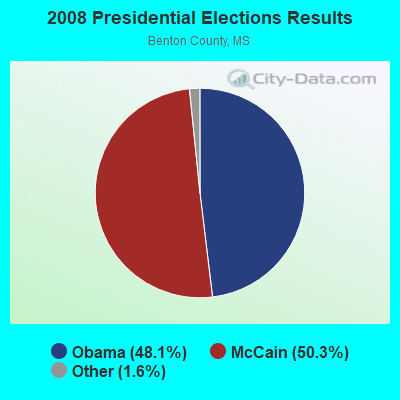
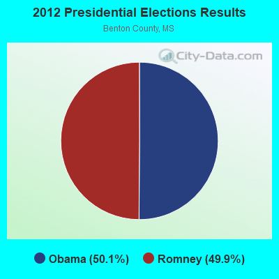
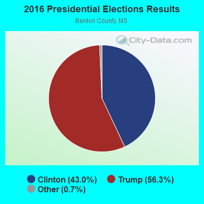
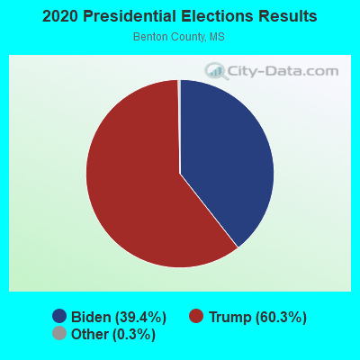
Graphs represent county-level data. Detailed 2008 Election Results
Religion statistics for Ashland, MS (based on Benton County data)
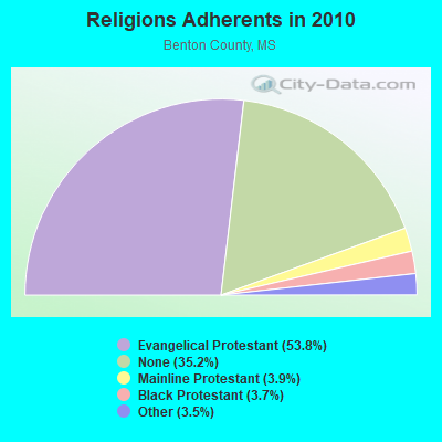
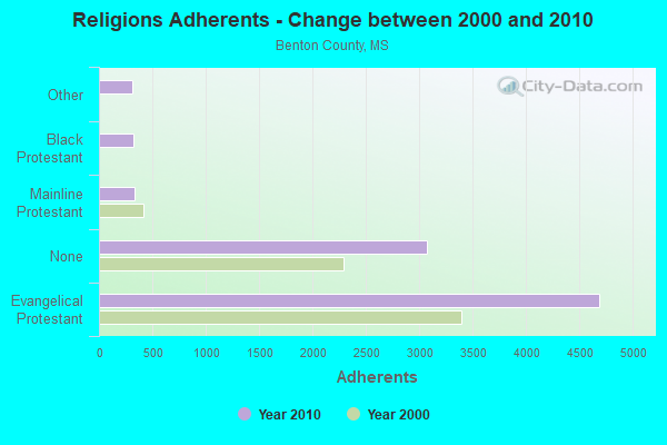
| Religion | Adherents | Congregations |
|---|---|---|
| Evangelical Protestant | 4,692 | 20 |
| Mainline Protestant | 337 | 7 |
| Black Protestant | 321 | 3 |
| Other | 308 | 1 |
| None | 3,071 | - |
Food Environment Statistics:
| Benton County: | 1.25 / 10,000 pop. |
| Mississippi: | 2.08 / 10,000 pop. |
| Benton County: | 9.98 / 10,000 pop. |
| State: | 6.36 / 10,000 pop. |
| This county: | 12.7% |
| Mississippi: | 12.3% |
| Benton County: | 34.6% |
| Mississippi: | 33.1% |
| This county: | 10.3% |
| State: | 14.4% |
Health and Nutrition:
| This city: | 57.3% |
| Mississippi: | 48.6% |
| This city: | 55.2% |
| State: | 45.3% |
| Ashland: | 28.0 |
| State: | 29.2 |
| Ashland: | 16.6% |
| State: | 20.5% |
| Ashland: | 8.7% |
| Mississippi: | 11.6% |
| This city: | 7.1 |
| State: | 6.7 |
| This city: | 33.8% |
| Mississippi: | 34.8% |
| This city: | 61.6% |
| State: | 54.9% |
| Here: | 78.9% |
| Mississippi: | 79.9% |
More about Health and Nutrition of Ashland, MS Residents
| Local government employment and payroll (March 2022) | |||||
| Function | Full-time employees | Monthly full-time payroll | Average yearly full-time wage | Part-time employees | Monthly part-time payroll |
|---|---|---|---|---|---|
| Other and Unallocable | 2 | $6,635 | $39,810 | 1 | $634 |
| Police Protection - Officers | 1 | $2,562 | $30,744 | 3 | $2,254 |
| Water Supply | 1 | $2,096 | $25,152 | 1 | $1,536 |
| Judicial and Legal | 0 | $0 | 3 | $1,536 | |
| Other Government Administration | 0 | $0 | 8 | $10,796 | |
| Totals for Government | 4 | $11,293 | $33,879 | 16 | $16,756 |
Ashland government finances - Expenditure in 2017 (per resident):
- Current Operations - Gas Utilities: $300,000 ($557.62)
Water Utilities: $232,000 ($431.23)
Financial Administration: $158,000 ($293.68)
General - Other: $79,000 ($146.84)
Police Protection: $59,000 ($109.67)
Miscellaneous Commercial Activities - Other: $36,000 ($66.91)
Regular Highways: $27,000 ($50.19)
Sewerage: $26,000 ($48.33)
Local Fire Protection: $14,000 ($26.02)
- Other Capital Outlay - Financial Administration: $90,000 ($167.29)
Water Utilities: $22,000 ($40.89)
- Total Salaries and Wages: $266,000 ($494.42)
- Water Utilities - Interest on Debt: $19,000 ($35.32)
Ashland government finances - Revenue in 2017 (per resident):
- Charges - Sewerage: $56,000 ($104.09)
Other: $36,000 ($66.91)
- Local Intergovernmental - Highways: $12,000 ($22.30)
Other: $7,000 ($13.01)
- Miscellaneous - General Revenue - Other: $131,000 ($243.49)
Fines and Forfeits: $7,000 ($13.01)
Interest Earnings: $2,000 ($3.72)
- Revenue - Gas Utilities: $308,000 ($572.49)
Water Utilities: $212,000 ($394.05)
- State Intergovernmental - General Local Government Support: $165,000 ($306.69)
Other: $12,000 ($22.30)
- Tax - Property: $61,000 ($113.38)
Other License: $7,000 ($13.01)
Other: $3,000 ($5.58)
Occupation and Business License - Other: $2,000 ($3.72)
Ashland government finances - Debt in 2017 (per resident):
- Long Term Debt - Outstanding Unspecified Public Purpose: $389,000 ($723.05)
Beginning Outstanding - Unspecified Public Purpose: $343,000 ($637.55)
Beginning Outstanding - Public Debt for Private Purpose: $262,000 ($486.99)
Outstanding Nonguaranteed - Industrial Revenue: $250,000 ($464.68)
Issue, Unspecified Public Purpose: $72,000 ($133.83)
Retired Unspecified Public Purpose: $25,000 ($46.47)
Retired Nonguaranteed - Public Debt for Private Purpose: $12,000 ($22.30)
Ashland government finances - Cash and Securities in 2017 (per resident):
- Sinking Funds - Cash and Securities: $250,000 ($464.68)
Businesses in Ashland, MS
- UPS: 1
Strongest AM radio stations in Ashland:
- WCRV (640 AM; 50 kW; COLLIERVILLE, TN; Owner: BOTT BROADCASTING COMPANY/TENNESSEE)
- WGSF (1030 AM; 50 kW; MEMPHIS, TN; Owner: FLINN BROADCASTING CORPORATION)
- WMQM (1600 AM; 50 kW; LAKELAND, TN; Owner: WMQM, INC.)
- WDIA (1070 AM; 50 kW; MEMPHIS, TN; Owner: CLEAR CHANNEL BROADCASTING LICENSES, INC.)
- WCPC (940 AM; 50 kW; HOUSTON, MS; Owner: WCPC BROADCASTING CO., INC.)
- WPLX (1170 AM; 10 kW; GERMANTOWN, TN; Owner: EDUCATIONAL MEDIA FOUNDATION)
- WKRA (1110 AM; daytime; 1 kW; HOLLY SPRINGS, MS; Owner: BILLY R. AUTRY)
- WJCE (680 AM; 10 kW; MEMPHIS, TN; Owner: ENTERCOM MEMPHIS LICENSE, LLC)
- KWAM (990 AM; 10 kW; MEMPHIS, TN; Owner: CONCORD MEDIA GROUP, INC.)
- WLRC (850 AM; daytime; 1 kW; WALNUT, MS; Owner: B. R. AND MARTHA S. CLAYTON)
- WSM (650 AM; 50 kW; NASHVILLE, TN; Owner: GAYLORD ENTERTAINMENT COMPANY)
- WMC (790 AM; 5 kW; MEMPHIS, TN; Owner: INFINITY RADIO OPERATIONS INC.)
- WREC (600 AM; 5 kW; MEMPHIS, TN; Owner: CLEAR CHANNEL BROADCASTING LICENSES, INC.)
Strongest FM radio stations in Ashland:
- WRBO (103.5 FM; COMO, MS; Owner: MEMPHIS III LIMITED PARTNERSHIP)
- WCNA (95.9 FM; POTTS CAMP, MS; Owner: OLVIE E. SISK)
- WKRA-FM (92.7 FM; HOLLY SPRINGS, MS; Owner: BILLY R. AUTRY)
- WZLQ (98.5 FM; TUPELO, MS; Owner: SAN DOW BROADCASTING)
- WSRR-FM (98.1 FM; MILLINGTON, TN; Owner: KOOL BROADCASTING, INC.)
- WMAE-FM (89.5 FM; BOONEVILLE, MS; Owner: MISSISSIPPI AUTHORITY FOR EDUCATIONAL TV)
- WKZU (102.3 FM; RIPLEY, MS; Owner: KUDZU COMMUNICATIONS, INC.)
- WWZD-FM (106.7 FM; NEW ALBANY, MS; Owner: CAPSTAR TX LIMITED PARTNERSHIP)
- WMAV-FM (90.3 FM; OXFORD, MS; Owner: MISSISSIPPI AUTHORITY FOR EDUCATIONAL TV)
- WURC (88.1 FM; HOLLY SPRINGS, MS; Owner: RUST COLLEGE, INC.)
- WGKX (105.9 FM; MEMPHIS, TN; Owner: KIX BROADCASTING, INC.)
- WRVR-FM (104.5 FM; MEMPHIS, TN; Owner: ENTERCOM MEMPHIS LICENSE, LLC)
TV broadcast stations around Ashland:
- WBII-LP (Channel 20; HOLLY SPRINGS, MS; Owner: MID-SOUTH BROADCASTING)
- WMC-TV (Channel 5; MEMPHIS, TN; Owner: RAYCOM AMERICA, INC.)
- WREG-TV (Channel 3; MEMPHIS, TN; Owner: NEW YORK TIMES MANAGEMENT SERVICES)
- WMAV-TV (Channel 18; OXFORD, MS; Owner: MISSISSIPPI AUTHORITY FOR EDUCATIONAL TELEVISION)
- WLMT (Channel 30; MEMPHIS, TN; Owner: CLEAR CHANNEL BROADCASTING LICENSES, INC.)
- WPTY-TV (Channel 24; MEMPHIS, TN; Owner: CLEAR CHANNEL BROADCASTING LICENSES, INC.)
- WKNO (Channel 10; MEMPHIS, TN; Owner: MID-SOUTH PUBLIC COMMUNICATIONS FOUNDATION)
- WMAE-TV (Channel 12; BOONEVILLE, MS; Owner: MISSISSIPPI AUTHORITY FOR EDUCATIONAL TV)
- WPXX-TV (Channel 50; MEMPHIS, TN; Owner: FLINN BROADCASTING CORPORATION)
- WHBQ-TV (Channel 13; MEMPHIS, TN; Owner: FOX TELEVISION STATIONS, INC.)
- W34BU (Channel 34; ACTON, TN; Owner: MS COMMUNICATIONS, LLC)
- WBUY (Channel 40; HOLLY SPRINGS, MS; Owner: TRINITY BROADCASTING NETWORK)
Ashland fatal accident list:
Nov 14, 2007 07:27 AM, Sr-370, Lat: 34.833814, Lon: -89.187381, Vehicles: 2, Persons: 4, Fatalities: 1
Feb 27, 2000 02:02 PM, Sr-4, Lat: 34.826978, Lon: -89.190409, Vehicles: 2, Persons: 3, Fatalities: 1
Dec 14, 1999 10:30 AM, Sr-4, Lat: 34.826978, Lon: -89.190409, Vehicles: 2, Persons: 2, Fatalities: 1
Dec 3, 1978 87:99 PM, Vehicles: 1, Persons: 3, Fatalities: 1
- National Bridge Inventory (NBI) Statistics
- 7Number of bridges
- 95ft / 29.5mTotal length
- $200,314,000Total costs
- 9,500Total average daily traffic
- 1,052Total average daily truck traffic
- 10,240Total future (year 2035) average daily traffic
FCC Registered Antenna Towers:
71 (See the full list of FCC Registered Antenna Towers in Ashland)FCC Registered Private Land Mobile Towers:
1- Hwy 370 1 Mi E Of Hwy 5 (Lat: 34.833694 Lon: -89.181444), Structure height: 46 m, Call Sign: WPBC334,
Assigned Frequencies: 462.750 MHz, 462.750 MHz, Grant Date: 10/27/1997, Expiration Date: 11/18/2007, Cancellation Date: 01/05/2008, Registrant: Carlos Wilson, Grand Junction, TN 38039, Phone: (901) 764-6161
FCC Registered Broadcast Land Mobile Towers:
2- Benton County Jail (Lat: 34.841750 Lon: -89.175056), Call Sign: WNDD751, Licensee ID: L00098443,
Assigned Frequencies: 45.3200 MHz, Grant Date: 04/25/2000, Expiration Date: 07/06/2005, Cancellation Date: 01/07/2006, Registrant: County Of Benton, Ashland, MS 38603, Phone: (601) 224-8941
- Lat: 34.828417 Lon: -84.218389, Call Sign: WPTM572,
Assigned Frequencies: 153.492 MHz, 158.227 MHz, Grant Date: 10/30/2001, Expiration Date: 10/30/2011, Cancellation Date: 09/19/2011, Certifier: Barry Glasser, Registrant: Kelson Energy, 6700 Alexander Bell Drive, Suite 360, Columbia, MD 21046, Phone: (703) 286-7743, Fax: (410) 872-9460, Email:
FCC Registered Microwave Towers:
4- 30412, 5082 Hwy 370 (Mswin 30412) (Lat: 34.847028 Lon: -89.103833), Type: Tower, Structure height: 129.5 m, Overall height: 132.6 m, Call Sign: WQOS447, Licensee ID: L01412109,
Assigned Frequencies: 6226.89 MHz, 6286.19 MHz, 6315.84 MHz, 6675.00 MHz, 6665.00 MHz, 6375.14 MHz, Grant Date: 12/15/2021, Expiration Date: 01/17/2032, Certifier: Bill Roach, Registrant: State Of Mississippi Wireless Communication Commission, 412 East Woodrow Wilson Ave., Mail Code 66-01, Jackson, MS 39216, Phone: (601) 359-5363, Fax: (601) 359-5362, Email:
- ASHLAND WT, 261 Industrial Road (Lat: 34.847528 Lon: -89.181222), Type: Tank, Structure height: 41.1 m, Call Sign: WQQB654,
Assigned Frequencies: 6212.06 MHz, 6212.06 MHz, 6212.06 MHz, 6212.06 MHz, 6212.06 MHz, 6212.06 MHz, 6212.06 MHz, 6212.06 MHz, 6212.06 MHz, 6212.06 MHz, 6315.84 MHz, Grant Date: 11/01/2022, Expiration Date: 10/17/2032, Certifier: Jeffrey R Strenkowski, Registrant: Morgan, Lewis & Bockius LLP, 1111 Pennsylvania Ave. Nw, Washington, DC 20004, Phone: (202) 739-3000, Fax: (202) 739-3001, Email:
- ASHLAND, 3.6 Mi Wnw Of (Lat: 34.857861 Lon: -89.238944), Overall height: 92.4 m, Call Sign: KUV90,
Assigned Frequencies: 6182.41 MHz, 6241.71 MHz, 6301.01 MHz, 6360.31 MHz, 6212.06 MHz, Grant Date: 02/21/2001, Expiration Date: 02/01/2011, Cancellation Date: 04/09/2011, Phone: (202) 857-6022
- ASHLAND, Ripley-Legrange Road (Lat: 34.852778 Lon: -89.057222), Type: Tower, Structure height: 73.2 m, Call Sign: WLC373, Licensee ID: L00896575,
Assigned Frequencies: 5945.20 MHz, 5945.20 MHz, 6004.50 MHz, 6004.50 MHz, 6063.80 MHz, 6063.80 MHz, 6123.10 MHz, 6123.10 MHz, Grant Date: 03/13/2001, Expiration Date: 02/01/2011, Cancellation Date: 04/09/2011, Certifier: Robert A Esty, Registrant: International Communications Group, Inc. D/B/A Corban Networks
FCC Registered Paging Towers:
1- 0.4 Mile East And 225 Feet North Of Intersection Of Hwys 5 & (Lat: 34.833694 Lon: -89.181444), Call Sign: KKB504, Licensee ID: L00130116,
Assigned Frequencies: 152.120 MHz, 152.060 MHz, Expiration Date: 04/01/1999, Registrant: North Mississippi Mobilphone, Inc., Michigan City, MS 38647
FCC Registered Amateur Radio Licenses:
5- Call Sign: KB5HPM, Licensee ID: L00173230, Grant Date: 02/10/2023, Expiration Date: 02/10/2033, Registrant: Kevin A Childers, 6706 Crawford Tower Road, Ashland, MS 38603
- Call Sign: KB5KEE, Licensee ID: L00173233, Grant Date: 05/26/2022, Expiration Date: 05/26/2032, Registrant: Melody G Childers, 6706 Crawford Tower Road, Ashland, MS 38603
- Call Sign: KC5GLW, Grant Date: 10/18/1994, Expiration Date: 05/10/2004, Cancellation Date: 12/14/1999, Registrant: Shelly D Lindsey, Ashland, MS 38603
- Call Sign: W5RBF, Previous Call Sign: WB5NNN, Licensee ID: L00394241, Grant Date: 09/29/2021, Expiration Date: 09/29/2031, Certifier: Robert B Flannigan, Registrant: Robert B Flannigan, 1635 Jordan Rd, Ashland, MS 38603
- Call Sign: K4WER, Previous Call Sign: KE5SSA, Licensee ID: L01366828, Grant Date: 08/23/2013, Expiration Date: 08/23/2023, Certifier: William E Rowzee, Registrant: William E Rowzee, 76 Ripley Ave, Ashland, MS 38603
FAA Registered Aircraft:
3- Aircraft: HARDY JEFFREY M DA-2B (Category: Land, Seats: 2, Weight: Up to 12,499 Pounds), Engine: CONT MOTOR C90-12F (95 HP) (Reciprocating)
N-Number: 606EH, N606EH, N-606EH, Serial Number: 277, Year manufactured: 2010, Airworthiness Date: 10/20/2010, Certificate Issue Date: 04/27/2012
Registrant (Individual): Robert B Flannigan, 1635 Jordan Rd, Ashland, MS 38603 - Aircraft: WILSON ALAN A CH701 (Category: Land, Seats: 2, Weight: Up to 12,499 Pounds), Engine: BOMBARDIER ROTAX (ALL) (Reciprocating)
N-Number: 6089X, N6089X, N-6089X, Serial Number: 7-1599, Year manufactured: 1999, Airworthiness Date: 07/23/1999, Certificate Issue Date: 11/05/2012
Registrant (Individual): Robert B Flannigan, 1635 Jordan Rd, Ashland, MS 38603 - Aircraft: FENTON DAVIS DA-2A (Category: Land, Seats: 2, Weight: Up to 12,499 Pounds, Speed: 85 mph), Engine: CONT MOTOR C90 SERIES (95 HP) (Reciprocating)
N-Number: 808F, N808F, N-808F, Serial Number: 100, Year manufactured: 1972, Airworthiness Date: 04/12/1979, Certificate Issue Date: 01/19/2012
Registrant (Individual): Robert B Flannigan, 1635 Jordan Rd, Ashland, MS 38603
2003 - 2018 National Fire Incident Reporting System (NFIRS) incidents
- Fire incident types reported to NFIRS in Ashland, MS
- 54661.7%Outside Fires
- 22125.0%Structure Fires
- 10712.1%Mobile Property/Vehicle Fires
- 111.2%Other
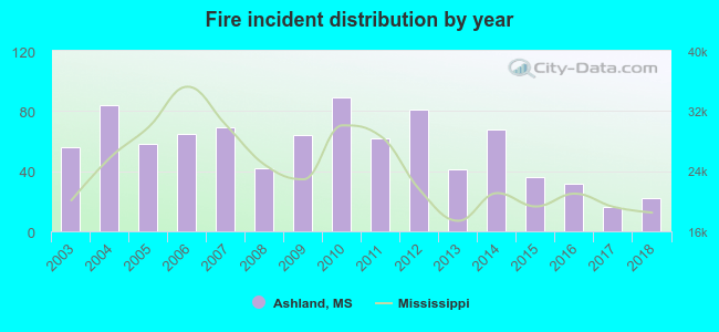 According to the data from the years 2003 - 2018 the average number of fires per year is 55. The highest number of reported fires - 89 took place in 2010, and the least - 16 in 2017. The data has a dropping trend.
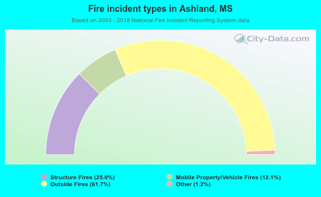 When looking into fire subcategories, the most incidents belonged to: Outside Fires (61.7%), and Structure Fires (25.0%).
| Most common first names in Ashland, MS among deceased individuals | ||
| Name | Count | Lived (average) |
|---|---|---|
| James | 52 | 76.7 years |
| Mary | 40 | 75.1 years |
| William | 37 | 74.8 years |
| John | 32 | 76.4 years |
| Robert | 24 | 70.5 years |
| George | 17 | 79.0 years |
| Thomas | 16 | 72.2 years |
| Willie | 13 | 82.1 years |
| Joe | 11 | 74.2 years |
| Henry | 10 | 75.8 years |
| Most common last names in Ashland, MS among deceased individuals | ||
| Last name | Count | Lived (average) |
|---|---|---|
| Simpson | 21 | 79.1 years |
| Childers | 21 | 78.1 years |
| Hopkins | 21 | 67.7 years |
| Smith | 16 | 77.4 years |
| Williams | 16 | 71.2 years |
| Jordan | 15 | 81.2 years |
| Strickland | 13 | 75.9 years |
| Cox | 13 | 77.6 years |
| Autry | 12 | 77.0 years |
| Taylor | 12 | 78.7 years |
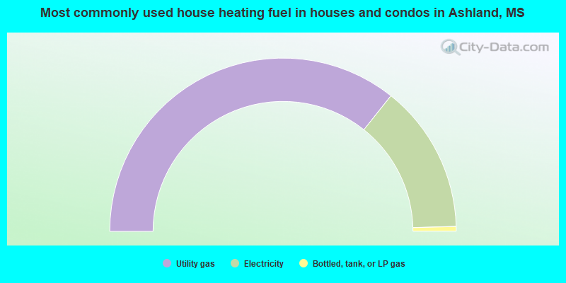
- 71.4%Utility gas
- 27.7%Electricity
- 0.9%Bottled, tank, or LP gas
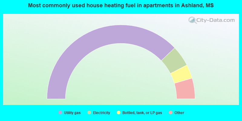
- 83.3%Utility gas
- 10.0%Electricity
- 6.7%Bottled, tank, or LP gas
Ashland compared to Mississippi state average:
- Median house value below state average.
- Unemployed percentage below state average.
- Black race population percentage below state average.
- Hispanic race population percentage significantly below state average.
- Median age significantly above state average.
- Foreign-born population percentage significantly below state average.
- Renting percentage below state average.
- Length of stay since moving in significantly below state average.
- House age above state average.
- Institutionalized population percentage significantly above state average.
- Percentage of population with a bachelor's degree or higher below state average.

|
Total of 1 patent application in 2008-2024.