Astoria, Oregon

Astoria: Astoria, OR
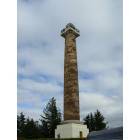
Astoria: astoria column

Astoria: Astoria, OR
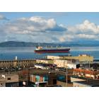
Astoria: Columbia River Estuary
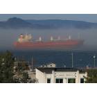
Astoria: Columbia River Fog
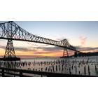
Astoria: Bridge at Sunset
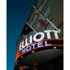
Astoria: Hotel Elliott

Astoria: Columbia Sunset

Astoria: An Astoria Bed & Breakfast
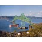
Astoria: Astoria-Megler Bridge
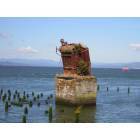
Astoria: Below the Bridge
- see
65
more - add
your
Submit your own pictures of this city and show them to the world
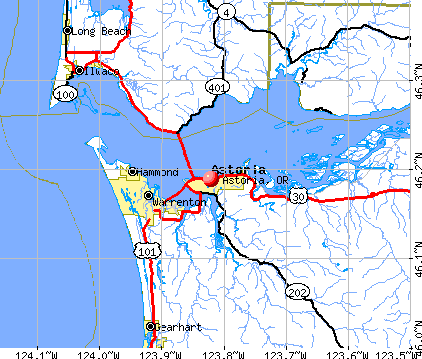
- OSM Map
- General Map
- Google Map
- MSN Map
Population change since 2000: +3.8%
 |
| Males: 5,044 | |
| Females: 5,138 |
| Median resident age: | 42.6 years |
| Oregon median age: | 40.5 years |
Zip codes: 97103.
| Astoria: | $68,579 |
| OR: | $75,657 |
Estimated per capita income in 2022: $39,362 (it was $18,759 in 2000)
Astoria city income, earnings, and wages data
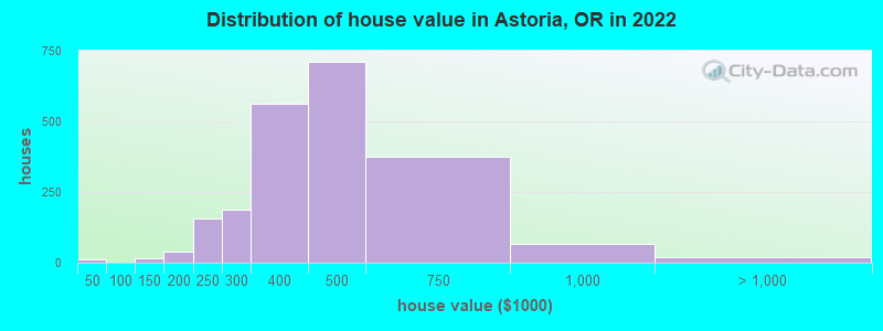
Estimated median house or condo value in 2022: $431,199 (it was $130,000 in 2000)
| Astoria: | $431,199 |
| OR: | $475,600 |
Mean prices in 2022: all housing units: $407,685; detached houses: $410,139; townhouses or other attached units: $357,104; in 2-unit structures: $364,587; in 3-to-4-unit structures: $404,024; in 5-or-more-unit structures: $463,486; mobile homes: $204,939
Median gross rent in 2022: $1,071.
(8.3% for White Non-Hispanic residents, 37.0% for Black residents, 29.2% for Hispanic or Latino residents, 55.6% for Native Hawaiian and other Pacific Islander residents, 0.9% for other race residents, 18.8% for two or more races residents)
Detailed information about poverty and poor residents in Astoria, OR


- 7,74375.8%White alone
- 1,41213.8%Hispanic
- 7987.8%Two or more races
- 1121.1%Asian alone
- 800.8%Black alone
- 260.3%American Indian alone
- 170.2%Native Hawaiian and Other
Pacific Islander alone
Races in Astoria detailed stats: ancestries, foreign born residents, place of birth
According to our research of Oregon and other state lists, there were 4 registered sex offenders living in Astoria, Oregon as of April 27, 2024.
The ratio of all residents to sex offenders in Astoria is 2,466 to 1.
The ratio of registered sex offenders to all residents in this city is near the state average.
Type |
2009 |
2010 |
2011 |
2012 |
2013 |
2014 |
2015 |
2016 |
2017 |
2018 |
2019 |
2020 |
2021 |
2022 |
|---|---|---|---|---|---|---|---|---|---|---|---|---|---|---|
| Murders (per 100,000) | 1 (10.1) | 1 (10.6) | 0 (0.0) | 0 (0.0) | 0 (0.0) | 0 (0.0) | 0 (0.0) | 0 (0.0) | 0 (0.0) | 0 (0.0) | 0 (0.0) | 0 (0.0) | 0 (0.0) | 0 (0.0) |
| Rapes (per 100,000) | 7 (71.0) | 1 (10.6) | 0 (0.0) | 1 (10.4) | 3 (31.4) | 10 (105.0) | 3 (31.5) | 0 (0.0) | 7 (71.0) | 12 (121.0) | 10 (99.6) | 13 (129.0) | 12 (119.0) | 14 (134.0) |
| Robberies (per 100,000) | 6 (60.9) | 4 (42.2) | 2 (20.9) | 10 (104.4) | 1 (10.5) | 6 (63.0) | 8 (83.9) | 5 (51.8) | 7 (71.0) | 7 (70.6) | 11 (109.6) | 8 (79.4) | 9 (89.2) | 8 (76.6) |
| Assaults (per 100,000) | 13 (131.9) | 7 (73.9) | 9 (94.0) | 11 (114.9) | 29 (303.9) | 9 (94.5) | 20 (209.8) | 11 (113.9) | 24 (243.5) | 16 (161.3) | 55 (547.8) | 40 (397.0) | 39 (386.7) | 25 (239.3) |
| Burglaries (per 100,000) | 100 (1,014) | 142 (1,498) | 66 (689.1) | 92 (960.8) | 89 (932.6) | 98 (1,029) | 145 (1,521) | 62 (642.2) | 68 (689.9) | 60 (605.0) | 66 (657.4) | 49 (486.3) | 71 (703.9) | 48 (459.4) |
| Thefts (per 100,000) | 415 (4,209) | 460 (4,854) | 309 (3,226) | 346 (3,614) | 324 (3,395) | 253 (2,656) | 391 (4,102) | 370 (3,832) | 345 (3,500) | 365 (3,680) | 257 (2,560) | 237 (2,352) | 210 (2,082) | 266 (2,546) |
| Auto thefts (per 100,000) | 21 (213.0) | 29 (306.0) | 17 (177.5) | 31 (323.8) | 32 (335.3) | 25 (262.4) | 19 (199.3) | 18 (186.4) | 38 (385.5) | 22 (221.8) | 15 (149.4) | 33 (327.5) | 20 (198.3) | 31 (296.7) |
| Arson (per 100,000) | 5 (50.7) | 5 (52.8) | 1 (10.4) | 2 (20.9) | 3 (31.4) | 3 (31.5) | 3 (31.5) | 3 (31.1) | 5 (50.7) | 8 (80.7) | 3 (29.9) | 4 (39.7) | 5 (49.6) | 8 (76.6) |
| City-Data.com crime index | 378.1 | 380.5 | 216.5 | 300.4 | 317.0 | 321.0 | 378.8 | 251.5 | 345.9 | 357.5 | 382.5 | 360.8 | 347.7 | 335.8 |
The City-Data.com crime index weighs serious crimes and violent crimes more heavily. Higher means more crime, U.S. average is 246.1. It adjusts for the number of visitors and daily workers commuting into cities.
Crime rate in Astoria detailed stats: murders, rapes, robberies, assaults, burglaries, thefts, arson
Full-time law enforcement employees in 2021, including police officers: 26 (16 officers - 14 male; 2 female).
| Officers per 1,000 residents here: | 1.59 |
| Oregon average: | 1.48 |
 Recent articles from our blog. Our writers, many of them Ph.D. graduates or candidates, create easy-to-read articles on a wide variety of topics.

 | Astoria or (50 replies) |
| Astoria Schools (0 replies) |
| Moving to Portland (24 replies) |
| Astoria man attempts getaway. Drives off pier (2 replies) |
| Best place to retire on the coast (117 replies) |
| Is the Coos Bay/Florence area the "Last Hidden Gem" of Oregon?? (106 replies) |
Latest news from Astoria, OR collected exclusively by city-data.com from local newspapers, TV, and radio stations
Astoria, OR City Guides:
Ancestries: American (11.0%), English (10.3%), Irish (9.4%), German (9.2%), European (5.7%), Norwegian (4.5%).
Current Local Time: PST time zone
Incorporated in 1856
Elevation: 18 feet
Land area: 6.14 square miles.
Population density: 1,658 people per square mile (low).
599 residents are foreign born (2.9% Latin America, 1.6% Europe, 0.9% Asia).
| This city: | 5.9% |
| Oregon: | 9.8% |
Median real estate property taxes paid for housing units with mortgages in 2022: $3,441 (0.8%)
Median real estate property taxes paid for housing units with no mortgage in 2022: $3,210 (0.8%)
Nearest city with pop. 50,000+: Hillsboro, OR  (62.5 miles , pop. 70,186).
Nearest city with pop. 200,000+: Portland, OR (73.2 miles , pop. 529,121).
Nearest city with pop. 1,000,000+: Los Angeles, CA (884.7 miles , pop. 3,694,820).
Nearest cities:
), ), Latitude: 46.19 N, Longitude: 123.82 W
Daytime population change due to commuting: +1,852 (+18.1%)
Workers who live and work in this city: 2,922 (61.9%)
Area code: 503
Astoria, Oregon accommodation & food services, waste management - Economy and Business Data
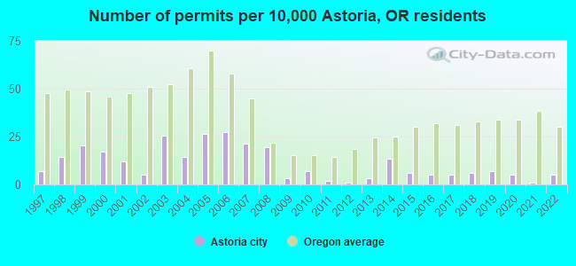
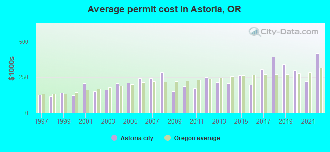
Single-family new house construction building permits:
- 2022: 5 buildings, average cost: $417,500
- 2021: 1 building, cost: $222,000
- 2020: 5 buildings, average cost: $295,700
- 2019: 7 buildings, average cost: $341,100
- 2018: 6 buildings, average cost: $390,700
- 2017: 5 buildings, average cost: $302,800
- 2016: 5 buildings, average cost: $196,600
- 2015: 6 buildings, average cost: $261,200
- 2014: 13 buildings, average cost: $208,000
- 2013: 3 buildings, average cost: $217,100
- 2012: 1 building, cost: $252,000
- 2011: 2 buildings, average cost: $172,200
- 2010: 7 buildings, average cost: $186,200
- 2009: 3 buildings, average cost: $153,000
- 2008: 19 buildings, average cost: $283,600
- 2007: 21 buildings, average cost: $244,200
- 2006: 27 buildings, average cost: $243,400
- 2005: 26 buildings, average cost: $212,900
- 2004: 14 buildings, average cost: $208,900
- 2003: 25 buildings, average cost: $161,300
- 2002: 5 buildings, average cost: $151,600
- 2001: 12 buildings, average cost: $208,500
- 2000: 17 buildings, average cost: $123,800
- 1999: 20 buildings, average cost: $139,700
- 1998: 14 buildings, average cost: $116,000
- 1997: 7 buildings, average cost: $125,700
| Here: | 4.0% |
| Oregon: | 3.9% |
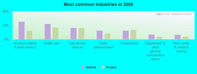
- Accommodation & food services (12.7%)
- Health care (11.2%)
- Educational services (8.4%)
- Public administration (6.5%)
- Construction (6.3%)
- Department & other general merchandise stores (3.5%)
- Real estate & rental & leasing (3.4%)
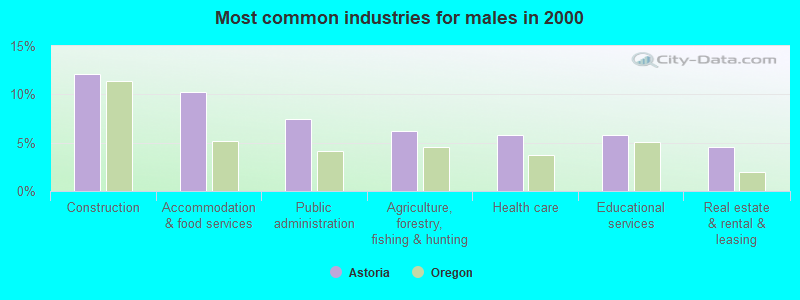
- Construction (12.1%)
- Accommodation & food services (10.2%)
- Public administration (7.5%)
- Agriculture, forestry, fishing & hunting (6.2%)
- Health care (5.8%)
- Educational services (5.8%)
- Real estate & rental & leasing (4.6%)
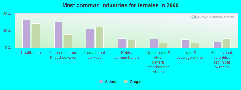
- Health care (16.4%)
- Accommodation & food services (15.1%)
- Educational services (10.9%)
- Public administration (5.4%)
- Department & other general merchandise stores (5.2%)
- Food & beverage stores (5.0%)
- Professional, scientific, technical services (3.6%)
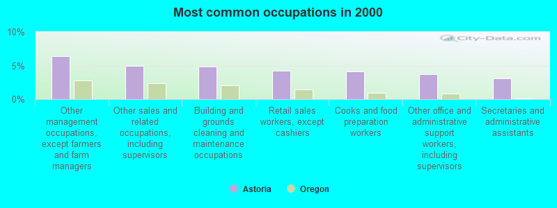
- Other management occupations, except farmers and farm managers (6.4%)
- Other sales and related occupations, including supervisors (4.9%)
- Building and grounds cleaning and maintenance occupations (4.8%)
- Retail sales workers, except cashiers (4.2%)
- Cooks and food preparation workers (4.1%)
- Other office and administrative support workers, including supervisors (3.7%)
- Secretaries and administrative assistants (3.0%)

- Other management occupations, except farmers and farm managers (7.2%)
- Cooks and food preparation workers (6.2%)
- Other production occupations, including supervisors (4.8%)
- Building and grounds cleaning and maintenance occupations (4.8%)
- Fishing, hunting, and forestry occupations (4.3%)
- Retail sales workers, except cashiers (3.8%)
- Vehicle and mobile equipment mechanics, installers, and repairers (3.7%)

- Other sales and related occupations, including supervisors (7.3%)
- Secretaries and administrative assistants (6.1%)
- Other office and administrative support workers, including supervisors (6.0%)
- Other management occupations, except farmers and farm managers (5.6%)
- Building and grounds cleaning and maintenance occupations (4.9%)
- Retail sales workers, except cashiers (4.6%)
- Cashiers (4.5%)
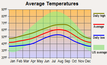
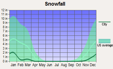
Average climate in Astoria, Oregon
Based on data reported by over 4,000 weather stations


|
|

Earthquake activity:
Astoria-area historical earthquake activity is significantly above Oregon state average. It is 1310% greater than the overall U.S. average.On 4/13/1949 at 19:55:42, a magnitude 7.0 (7.0 UK, Class: Major, Intensity: VIII - XII) earthquake occurred 96.5 miles away from the city center, causing $80,000,000 total damage
On 2/28/2001 at 18:54:32, a magnitude 6.8 (6.8 MD, Depth: 32.2 mi, Class: Strong, Intensity: VII - IX) earthquake occurred 84.3 miles away from Astoria center
On 2/28/2001 at 18:54:32, a magnitude 6.8 (6.5 MB, 6.6 MS, 6.8 MW) earthquake occurred 85.8 miles away from the city center, causing $2,000,000,000 total damage and $305,000,000 insured losses
On 4/29/1965 at 15:28:43, a magnitude 6.6 (6.6 UK) earthquake occurred 105.2 miles away from the city center, causing $28,000,000 total damage
On 1/31/1922 at 13:17:28, a magnitude 7.6 (7.6 UK) earthquake occurred 389.5 miles away from Astoria center
On 8/17/1991 at 22:17:14, a magnitude 7.1 (6.2 MB, 7.1 MS, 7.1 MW, 6.8 ML, Depth: 8.4 mi) earthquake occurred 319.5 miles away from the city center
Magnitude types: body-wave magnitude (MB), duration magnitude (MD), local magnitude (ML), surface-wave magnitude (MS), moment magnitude (MW)
Natural disasters:
The number of natural disasters in Clatsop County (16) is near the US average (15).Major Disasters (Presidential) Declared: 15
Emergencies Declared: 1
Causes of natural disasters: Floods: 11, Storms: 8, Landslides: 6, Mudslides: 6, Winter Storms: 5, Winds: 2, Heavy Rain: 1, Hurricane: 1, Snow: 1, Other: 1 (Note: some incidents may be assigned to more than one category).
Hospitals and medical centers in Astoria:
- COLUMBIA MEMORIAL HOSPITAL (Proprietary, provides emergency services, 2111 EXCHANGE STREET)
- LOWER COLUMBIA HOSPICE (486 12TH STREET)
- CLATSOP BRIDGES CARE CENTER (263 WEST EXCHANGE ST)
- CLATSOP CARE CENTER (646 16TH STREET)
- PNRS ASTORIA DIALYSIS (2120 EXCHANGE ST, STE 100)
- COLUMBIA MEMORIAL HOSPITAL (486 12TH STREET)
Airports and heliports located in Astoria:
- Astoria Regional Airport (AST) (Runways: 2, Air Taxi Ops: 1,651, Itinerant Ops: 11,660, Local Ops: 11,410, Military Ops: 14,000)
- Karpens Airport (OR23) (Runways: 1)
- Columbia Memorial Hospital Heliport (OG03)
- Station Thirty Heliport (OG56)
College/University in Astoria:
Colleges/universities with over 2000 students nearest to Astoria:
- Lower Columbia College (about 43 miles; Longview, WA; Full-time enrollment: 2,595)
- Centralia College (about 55 miles; Centralia, WA; FT enrollment: 2,354)
- Pacific University (about 58 miles; Forest Grove, OR; FT enrollment: 2,967)
- University of Portland (about 68 miles; Portland, OR; FT enrollment: 4,030)
- Clark College (about 69 miles; Vancouver, WA; FT enrollment: 9,330)
- Concordia University-Portland (about 72 miles; Portland, OR; FT enrollment: 3,996)
- South Puget Sound Community College (about 72 miles; Olympia, WA; FT enrollment: 3,981)
Public high schools in Astoria:
- ASTORIA SENIOR HIGH SCHOOL (Students: 742, Location: 1001 W MARINE DR, Grades: 9-12)
- KNAPPA HIGH SCHOOL (Students: 185, Location: 41535 OLD HWY 30, Grades: 9-12)
Public elementary/middle schools in Astoria:
- ASTOR ELEMENTARY SCHOOL (Students: 401, Location: 3550 FRANKLIN AVE, Grades: KG-2)
- LEWIS & CLARK ELEMENTARY SCHOOL (Students: 401, Location: 92179 LEWIS AND CLARK RD, Grades: 3-5)
- HILDA LAHTI ELEMENTARY SCHOOL (Students: 353, Location: 41535 OLD HWY 30, Grades: KG-8)
- ASTORIA MIDDLE SCHOOL (Students: 303, Location: 1100 KLASKANINE AVE, Grades: 6-8)
Points of interest:
Notable locations in Astoria: City of Astoria Wastewater Treatment Facility (A), Bonneville Power Station (B), Astoria Transit Center (C), 17th Street Transient Dock (D), Columbia River Maritime Museum Park and Ride (E), Astoria Bridge Toll Plaza (F), Young's Bay Marine Park - Yacht Club Boat Launch (G), Clatsop County Public Health Department (H), Astoria Fire Department Station 1 (I), Red Cross Astoria Satellite Office (J), Astoria Public Library (K), Astoria Fire Department Station 2 (L), Astor Street Opry Company Live Theatre (M), Liberty Theatre (N), Clatsop County Public Works (O), Astoria Public Works Operations (P), Heritage Museum (Q), Captain George Flavel House (R), Uppertown Firefighters Museum (S), Medix Ambulance Service (T). Display/hide their locations on the map
Churches in Astoria include: First Church of the Nazarene (A), Grace Episcopal Church (B). Display/hide their locations on the map
Cemeteries: Pioneer Cemetery (1), Riverview Cemetery (2). Display/hide their locations on the map
Reservoirs: Astoria Reservoir (A), Astoria Reservoir Number Two (B). Display/hide their locations on the map
Creeks: Craig Creek (A), Mill Creek (B). Display/hide their locations on the map
Parks in Astoria include: Astoria Column (1), Shively Park (2), John Warren Field (3), Tapiola Park (4). Display/hide their locations on the map
Tourist attractions: Clatsop County Historical Society (Museums; 714 Exchange Street) (1), Columbia River Maritime Museum (1792 Marine Drive) (2), Heritage Center Museum (1618 Exchange Street) (3), Astoria Railroad Preservation Association (Museums; Po Box 541) (4), Ross & Raw Vending (Amusement & Theme Parks; 437 30th Street) (5), The Riverpark Suite (No. 10 Sixth Street) (6), Lewis & Clark Explorer Train Packages (Tours & Charters; 750 Marine Drive) (7). Display/hide their approximate locations on the map
Hotels: Clementines Bed & Breakfast (847 Exchange Street) (1), Bayview Cottages (783 W Marine Dr) (2), Rosebriar Hotel (636 14th Street) (3), Red Lion Inn Astoria (400 Industry Street) (4), No 10 Sixth St Limited (10 6th Street Suite 101A) (5), Penthouse (10 6th Street Suite 101A) (6), Holiday Inn Express Hotel & Suites (204 West Marine Drive) (7), Comfort Suites (3420 Lief Erikson Drive) (8), Columbia Inn (495 Marine Drive) (9). Display/hide their approximate locations on the map
Courts: Astoria City - Municipal Court- Court Clerk (1095 Duane Street) (1), Oregon State - Courts- Circuit Court (Courthouse) (2). Display/hide their approximate locations on the map
Birthplace of: Harry Grayson - Sportswriter, Alexander G. Barry - Army officer, Brian Bruney - 2005 Major League Baseball player (Arizona Diamondbacks, born: Feb 17, 1982), Donald Malarkey - Soilder, Gene Nelson - Actor, Wally Johansen - Basketball player, Eric Zener - Artist, Jim Sullivan (Wisconsin politician) - Politician, Del Bjork - Football player, Jim Norene - Soilder.
Drinking water stations with addresses in Astoria and their reported violations in the past:
ASTORIA, CITY OF (Population served: 9,477, Surface water):Past health violations:JOHN DAY WATER DISTRICT (Population served: 350, Purch surface water):Past monitoring violations:
- Treatment Technique (SWTR and GWR) - In SEP-2013. Follow-up actions: St Public Notif received (SEP-19-2013), St Public Notif requested (OCT-24-2013), St Compliance achieved (NOV-26-2013)
- Treatment Technique (SWTR and GWR) - In SEP-2013. Follow-up actions: St Public Notif received (SEP-19-2013), St Public Notif requested (OCT-24-2013), St Compliance achieved (NOV-26-2013)
- MCL, Monthly (TCR) - In OCT-2006, Contaminant: Coliform. Follow-up actions: St Compliance achieved (DEC-06-2006)
- One routine major monitoring violation
Past monitoring violations:BURNSIDE WATER ASSOCIATION (Population served: 315, Purch surface water):
- Monitoring and Reporting (DBP) - In JAN-2009, Contaminant: TTHM. Follow-up actions: St Violation/Reminder Notice (FEB-22-2010), St Compliance achieved (OCT-14-2010)
- Monitoring and Reporting (DBP) - In JAN-2009, Contaminant: Total Haloacetic Acids (HAA5). Follow-up actions: St Violation/Reminder Notice (FEB-22-2010), St Compliance achieved (OCT-14-2010)
- Monitoring and Reporting (DBP) - Between JAN-2007 and DEC-2007, Contaminant: TTHM. Follow-up actions: St Compliance achieved (NOV-26-2008)
- Monitoring and Reporting (DBP) - Between JAN-2007 and DEC-2007, Contaminant: Total Haloacetic Acids (HAA5). Follow-up actions: St Compliance achieved (NOV-26-2008)
- Monitoring and Reporting (DBP) - Between JAN-2006 and DEC-2006, Contaminant: TTHM. Follow-up actions: St Compliance achieved (NOV-26-2008)
- 3 other older monitoring violations
Past monitoring violations:FERNHILL COMMUNITY WTR SYSTEM (Population served: 300, Purch surface water):
- Monitoring and Reporting (DBP) - Between JAN-2008 and DEC-2008, Contaminant: TTHM. Follow-up actions: St Compliance achieved (AUG-10-2009)
- Monitoring and Reporting (DBP) - Between JAN-2008 and DEC-2008, Contaminant: Total Haloacetic Acids (HAA5). Follow-up actions: St Compliance achieved (AUG-10-2009)
- Monitoring and Reporting (DBP) - Between JAN-2006 and DEC-2006, Contaminant: TTHM. Follow-up actions: St Compliance achieved (NOV-28-2007)
- Monitoring and Reporting (DBP) - Between JAN-2006 and DEC-2006, Contaminant: Total Haloacetic Acids (HAA5). Follow-up actions: St Compliance achieved (NOV-28-2007)
- Follow-up Or Routine LCR Tap M/R - In JAN-01-2005, Contaminant: Lead and Copper Rule. Follow-up actions: St Compliance achieved (DEC-18-2006)
- 4 other older monitoring violations
Past monitoring violations:ODF NORTHRUP CREEK HORSE CAMP HP (Population served: 55, Groundwater):
- Monitoring and Reporting (DBP) - Between JAN-2012 and DEC-2012, Contaminant: Total Haloacetic Acids (HAA5). Follow-up actions: St Violation/Reminder Notice (FEB-04-2013), St Compliance achieved (SEP-24-2013)
- Monitoring and Reporting (DBP) - Between JAN-2012 and DEC-2012, Contaminant: TTHM. Follow-up actions: St Violation/Reminder Notice (FEB-04-2013), St Compliance achieved (SEP-24-2013)
- Monitoring and Reporting (DBP) - In JAN-2009, Contaminant: TTHM. Follow-up actions: St Violation/Reminder Notice (FEB-22-2010), St Compliance achieved (OCT-14-2010)
- Monitoring and Reporting (DBP) - In JAN-2009, Contaminant: Total Haloacetic Acids (HAA5). Follow-up actions: St Violation/Reminder Notice (FEB-22-2010), St Compliance achieved (OCT-14-2010)
- Monitoring and Reporting (DBP) - Between JAN-2006 and DEC-2006, Contaminant: Total Haloacetic Acids (HAA5). Follow-up actions: St Compliance achieved (NOV-28-2007)
- 6 other older monitoring violations
Past health violations:ODF SPRUCE RUN PARK (Population served: 40, Groundwater):Past monitoring violations:
- MCL, Monthly (TCR) - Between APR-2012 and JUN-2012, Contaminant: Coliform. Follow-up actions: St Public Notif requested (JUN-19-2012), St Violation/Reminder Notice (JUN-25-2012), St Compliance achieved (2 times from SEP-25-2012 to DEC-17-2012)
- 3 routine major monitoring violations
- 2 regular monitoring violations
Past monitoring violations:
- One routine major monitoring violation
- 2 minor monitoring violations
- 2 regular monitoring violations
Drinking water stations with addresses in Astoria that have no violations reported:
- KNAPPA WATER ASSOCIATION (Population served: 1,800, Primary Water Source Type: Groundwater)
| This city: | 2.1 people |
| Oregon: | 2.5 people |
| This city: | 53.0% |
| Whole state: | 63.4% |
| This city: | 7.8% |
| Whole state: | 8.0% |
Likely homosexual households (counted as self-reported same-sex unmarried-partner households)
- Lesbian couples: 0.4% of all households
- Gay men: 0.4% of all households
People in group quarters in Astoria in 2010:
- 68 people in local jails and other municipal confinement facilities
- 64 people in workers' group living quarters and job corps centers
- 59 people in nursing facilities/skilled-nursing facilities
- 33 people in emergency and transitional shelters (with sleeping facilities) for people experiencing homelessness
- 16 people in group homes intended for adults
- 9 people in other noninstitutional facilities
- 6 people in residential treatment centers for adults
People in group quarters in Astoria in 2000:
- 106 people in nursing homes
- 66 people in local jails and other confinement facilities (including police lockups)
- 28 people in other noninstitutional group quarters
- 10 people in homes for the mentally retarded
- 7 people in crews of maritime vessels
- 6 people in military ships
Banks with branches in Astoria (2011 data):
- Sterling Savings Bank: Astoria at 303 11th St, branch established on 1985/06/30. Info updated 2012/03/21: Bank assets: $9,207.8 mil, Deposits: $6,454.1 mil, headquarters in Spokane, WA, positive income, Commercial Lending Specialization, 192 total offices, Holding Company: Sterling Financial Corporation
- Columbia State Bank: Astoria Branch at 1122 Duane Street, branch established on 1968/12/23. Info updated 2011/08/09: Bank assets: $4,785.2 mil, Deposits: $3,892.8 mil, headquarters in Tacoma, WA, positive income, Commercial Lending Specialization, 104 total offices, Holding Company: Columbia Banking System, Inc.
- Clatsop Community Bank: Astoria Branch at 988 Commercial St, branch established on 2009/01/12. Info updated 2010/07/26: Bank assets: $55.8 mil, Deposits: $47.1 mil, headquarters in Seaside, OR, positive income, Commercial Lending Specialization, 2 total offices
- Wells Fargo Bank, National Association: Astoria Branch at 1218 Commercial Street, branch established on 1900/01/01. Info updated 2011/04/05: Bank assets: $1,161,490.0 mil, Deposits: $905,653.0 mil, headquarters in Sioux Falls, SD, positive income, 6395 total offices, Holding Company: Wells Fargo & Company
- U.S. Bank National Association: Astoria Branch at 987 Duane, branch established on 1937/07/19. Info updated 2012/01/30: Bank assets: $330,470.8 mil, Deposits: $236,091.5 mil, headquarters in Cincinnati, OH, positive income, 3121 total offices, Holding Company: U.S. Bancorp
For population 15 years and over in Astoria:
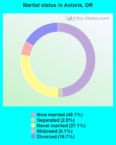
- Never married: 27.1%
- Now married: 48.1%
- Separated: 2.0%
- Widowed: 6.1%
- Divorced: 16.7%
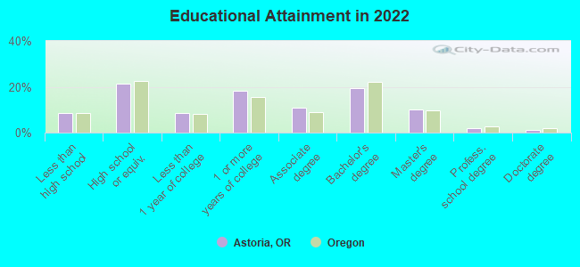
For population 25 years and over in Astoria:
- High school or higher: 91.1%
- Bachelor's degree or higher: 31.7%
- Graduate or professional degree: 12.6%
- Unemployed: 6.9%
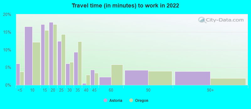
- Mean travel time to work (commute): 15.6 minutes
| Here: | 9.5 |
| Oregon average: | 11.6 |
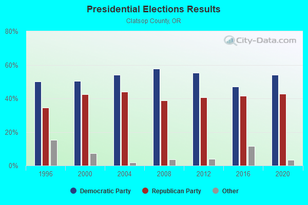
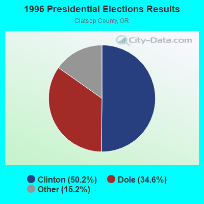
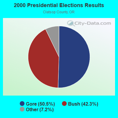


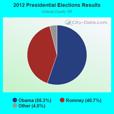

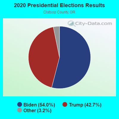
Graphs represent county-level data. Detailed 2008 Election Results
Religion statistics for Astoria, OR (based on Clatsop County data)
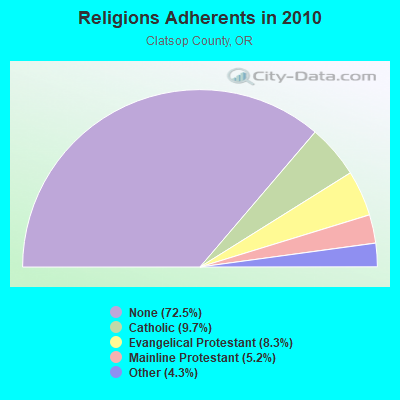
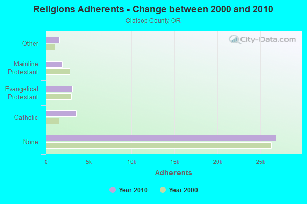
| Religion | Adherents | Congregations |
|---|---|---|
| Catholic | 3,595 | 3 |
| Evangelical Protestant | 3,075 | 31 |
| Mainline Protestant | 1,942 | 13 |
| Other | 1,590 | 9 |
| None | 26,837 | - |
Food Environment Statistics:
| Clatsop County: | 4.02 / 10,000 pop. |
| Oregon: | 2.03 / 10,000 pop. |
| This county: | 0.54 / 10,000 pop. |
| State: | 0.33 / 10,000 pop. |
| Clatsop County: | 1.34 / 10,000 pop. |
| Oregon: | 2.01 / 10,000 pop. |
| Clatsop County: | 4.02 / 10,000 pop. |
| State: | 1.69 / 10,000 pop. |
| Here: | 27.88 / 10,000 pop. |
| State: | 9.93 / 10,000 pop. |
| This county: | 8.9% |
| Oregon: | 7.4% |
| Clatsop County: | 24.7% |
| Oregon: | 25.6% |
| This county: | 6.6% |
| State: | 14.2% |
Health and Nutrition:
| Astoria: | 49.9% |
| Oregon: | 49.6% |
| Here: | 46.7% |
| Oregon: | 46.8% |
| This city: | 28.4 |
| Oregon: | 28.5 |
| Astoria: | 21.3% |
| State: | 21.2% |
| Here: | 10.1% |
| Oregon: | 10.1% |
| Astoria: | 6.9 |
| State: | 6.8 |
| Astoria: | 33.8% |
| Oregon: | 33.3% |
| This city: | 56.1% |
| Oregon: | 56.5% |
| Astoria: | 78.0% |
| Oregon: | 78.7% |
More about Health and Nutrition of Astoria, OR Residents
| Local government employment and payroll (March 2022) | |||||
| Function | Full-time employees | Monthly full-time payroll | Average yearly full-time wage | Part-time employees | Monthly part-time payroll |
|---|---|---|---|---|---|
| Police Protection - Officers | 18 | $127,091 | $84,727 | 0 | $0 |
| Water Supply | 13 | $73,670 | $68,003 | 2 | $7,313 |
| Firefighters | 12 | $90,618 | $90,618 | 8 | $1,466 |
| Parks and Recreation | 10 | $48,401 | $58,081 | 52 | $51,827 |
| Police - Other | 9 | $61,376 | $81,835 | 2 | $1,288 |
| Streets and Highways | 9 | $58,992 | $78,656 | 1 | $479 |
| Sewerage | 7 | $31,662 | $54,278 | 0 | $0 |
| Financial Administration | 6 | $30,910 | $61,820 | 0 | $0 |
| Housing and Community Development (Local) | 6 | $30,400 | $60,800 | 2 | $4,875 |
| Local Libraries | 4 | $21,003 | $63,009 | 4 | $3,402 |
| Other Government Administration | 3 | $24,278 | $97,112 | 6 | $1,660 |
| Solid Waste Management | 1 | $4,834 | $58,008 | 0 | $0 |
| Judicial and Legal | 1 | $3,732 | $44,784 | 0 | $0 |
| Fire - Other | 0 | $0 | 1 | $1,665 | |
| Totals for Government | 99 | $606,965 | $73,572 | 78 | $73,975 |
Astoria government finances - Expenditure in 2021 (per resident):
- Current Operations - Police Protection: $3,909,000 ($383.91)
General - Other: $2,773,000 ($272.34)
Parks and Recreation: $2,592,000 ($254.57)
Water Utilities: $2,033,000 ($199.67)
Local Fire Protection: $1,880,000 ($184.64)
Sewerage: $1,348,000 ($132.39)
Central Staff Services: $894,000 ($87.80)
Financial Administration: $688,000 ($67.57)
Libraries: $542,000 ($53.23)
Regular Highways: $529,000 ($51.95)
Judicial and Legal Services: $279,000 ($27.40)
Protective Inspection and Regulation - Other: $234,000 ($22.98)
General Public Buildings: $66,000 ($6.48)
Solid Waste Management: $32,000 ($3.14)
Sea and Inland Port Facilities: $21,000 ($2.06)
- General - Interest on Debt: $788,000 ($77.39)
- Other Capital Outlay - Water Utilities: $2,048,000 ($201.14)
Sewerage: $547,000 ($53.72)
Parks and Recreation: $457,000 ($44.88)
General - Other: $277,000 ($27.20)
Police Protection: $180,000 ($17.68)
Local Fire Protection: $149,000 ($14.63)
Judicial and Legal Services: $128,000 ($12.57)
Financial Administration: $59,000 ($5.79)
Sea and Inland Port Facilities: $25,000 ($2.46)
- Total Salaries and Wages: $13,569,000 ($1332.65)
- Water Utilities - Interest on Debt: $115,000 ($11.29)
Astoria government finances - Revenue in 2021 (per resident):
- Charges - Sewerage: $4,125,000 ($405.13)
Parks and Recreation: $1,272,000 ($124.93)
Other: $1,151,000 ($113.04)
Sea and Inland Port Facilities: $73,000 ($7.17)
Miscellaneous Commercial Activities: $4,000 ($0.39)
- Federal Intergovernmental - Other: $239,000 ($23.47)
- Miscellaneous - Interest Earnings: $323,000 ($31.72)
General Revenue - Other: $279,000 ($27.40)
Fines and Forfeits: $251,000 ($24.65)
Special Assessments: $203,000 ($19.94)
- Revenue - Water Utilities: $4,312,000 ($423.49)
- State Intergovernmental - Highways: $837,000 ($82.20)
Other: $776,000 ($76.21)
Sewerage: $430,000 ($42.23)
General Local Government Support: $143,000 ($14.04)
Water Utilities: $139,000 ($13.65)
- Tax - Property: $8,368,000 ($821.84)
Other Selective Sales: $2,361,000 ($231.88)
Public Utilities Sales: $1,222,000 ($120.02)
Motor Fuels Sales: $271,000 ($26.62)
Occupation and Business License - Other: $90,000 ($8.84)
Other License: $40,000 ($3.93)
Astoria government finances - Debt in 2021 (per resident):
- Long Term Debt - Beginning Outstanding - Unspecified Public Purpose: $44,917,000 ($4411.41)
Outstanding Unspecified Public Purpose: $43,261,000 ($4248.77)
Retired Unspecified Public Purpose: $1,656,000 ($162.64)
Astoria government finances - Cash and Securities in 2021 (per resident):
- Other Funds - Cash and Securities: $51,943,000 ($5101.45)
- Sinking Funds - Cash and Securities: $1,296,000 ($127.28)
| Businesses in Astoria, OR | ||||
| Name | Count | Name | Count | |
|---|---|---|---|---|
| Best Western | 1 | MasterBrand Cabinets | 2 | |
| Burger King | 1 | McDonald's | 1 | |
| Comfort Suites | 1 | New Balance | 1 | |
| Curves | 1 | Nike | 2 | |
| Dairy Queen | 1 | SAS Shoes | 1 | |
| FedEx | 3 | Sears | 1 | |
| Ford | 1 | Starbucks | 1 | |
| H&R Block | 2 | True Value | 1 | |
| Holiday Inn | 1 | U-Haul | 2 | |
| JCPenney | 1 | UPS | 2 | |
| KFC | 1 | Vans | 1 | |
| Lane Furniture | 1 | Vons | 1 | |
Strongest AM radio stations in Astoria:
- KKEE (1230 AM; 1 kW; ASTORIA, OR; Owner: NEW NORTHWEST BROADCASTERS, LLC)
- KAST (1370 AM; 10 kW; ASTORIA, OR; Owner: NEW NORTHWEST BROADCASTERS, LLC)
- KPOJ (620 AM; 50 kW; PORTLAND, OR; Owner: CITICASTERS LICENSES, L.P.)
- KPAM (860 AM; 50 kW; TROUTDALE, OR; Owner: PAMPLIN BROADCASTING-OREGON, INC.)
- KXL (750 AM; 50 kW; PORTLAND, OR; Owner: ROSE CITY RADIO CORPORATION)
- KOTK (1080 AM; 50 kW; PORTLAND, OR; Owner: FISHER BROADCASTING - PORTLAND RADIO, L.L.C.)
- KEX (1190 AM; 50 kW; PORTLAND, OR; Owner: CITICASTERS LICENSES, L.P.)
- KKAD (1550 AM; 50 kW; VANCOUVER, WA; Owner: PAMPLIN BROADCASTING-WASHINGTON, INC)
- KIRO (710 AM; 50 kW; SEATTLE, WA; Owner: ENTERCOM SEATTLE LICENSE, LLC)
- KTTH (770 AM; 50 kW; SEATTLE, WA; Owner: ENTERCOM SEATTLE LICENSE, LLC)
- KJR (950 AM; 50 kW; SEATTLE, WA)
- KKSN (1520 AM; 50 kW; OREGON CITY, OR; Owner: ENTERCOM PORTLAND LICENSE, LLC)
- KGNW (820 AM; 50 kW; BURIEN-SEATTLE, WA; Owner: INSPIRATION MEDIA, INC.)
Strongest FM radio stations in Astoria:
- KAST-FM (92.9 FM; ASTORIA, OR; Owner: NEW NORTHWEST BROADCASTERS, LLC)
- KMUN (91.9 FM; ASTORIA, OR; Owner: TILLICUM FOUNDATION)
- KWYA (89.7 FM; ASTORIA, OR; Owner: WAY-FM MEDIA GROUP, INC.)
- K211ET (90.1 FM; ASTORIA, OR; Owner: WORLD RADIO NETWORK, INC.)
- K216DH (91.1 FM; CATHLAMET, WA; Owner: TILLICUM FOUNDATION)
- KCBZ (94.9 FM; CANNON BEACH, OR; Owner: ENTERCOM PORTLAND LICENSE, LLC)
- KMNT (102.9 FM; CENTRALIA, WA; Owner: CITICASTERS LICENSES, L.P.)
- KFMY (97.7 FM; RAYMOND, WA; Owner: SOUTH SOUND BROADCASTING, LLC)
- KRQT (107.1 FM; CASTLE ROCK, WA; Owner: ENTERCOM LONGVIEW LICENSE, LLC)
- K273AI (102.5 FM; ARIEL, WA; Owner: CALVARY CHAPEL OF TWIN FALLS, INC.)
- K289AC (105.7 FM; NEDONNA BEACH, OR; Owner: OREGON PUBLIC BROADCASTING)
- KVAS (103.9 FM; ILWACO, WA; Owner: NEW NORTHWEST BROADCASTERS, LLC)
- KJET (105.7 FM; SOUTH BEND, WA; Owner: JODESHA BROADCASTING, INC.)
- K216BQ (91.1 FM; SOUTH ASTORIA, OR; Owner: TILLICUM FOUNDATION/KMUN)
- KCYS (98.1 FM; SEASIDE, OR; Owner: DAVE'S BROADCASTING CORPORATION)
- KAQX (94.3 FM; LONG BEACH, WA; Owner: NEW NORTHWEST BROADCASTERS, LLC)
- K220HE (91.9 FM; CHEHALIS, WA; Owner: CALVARY CHAPEL OF TWIN FALLS, INC.)
- KCRX-FM (102.3 FM; SEASIDE, OR; Owner: NEW NORTHWEST BROADCASTERS, LLC)
- K265CP (100.9 FM; ASTORIA, OR; Owner: GOSPEL ECHO INC.)
- K280DF (103.9 FM; ASTORIA, OR; Owner: ASTORIA GOSPEL ECHO, INC.)
TV broadcast stations around Astoria:
- K26DB (Channel 26; ASTORIA, OR; Owner: FISHER BROADCASTING - PORTLAND TV, L.L.C.)
- K28FP (Channel 28; ASTORIA, OR; Owner: GREGORY J. HERMAN)
- K34DC (Channel 34; ASTORIA, OR; Owner: EMMIS TELEVISION LICENSE CORPORATION)
- National Bridge Inventory (NBI) Statistics
- 27Number of bridges
- 3,209ft / 978mTotal length
- $11,978,000Total costs
- 199,751Total average daily traffic
- 17,276Total average daily truck traffic
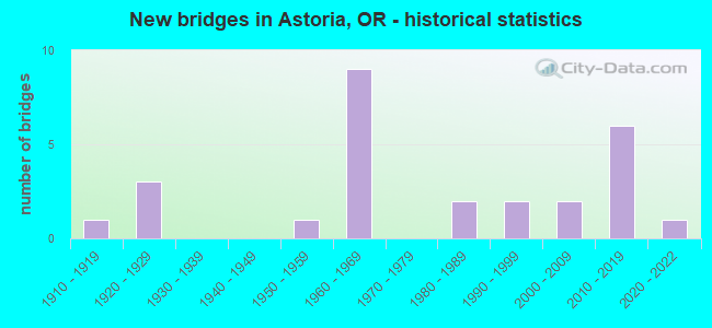
- New bridges - historical statistics
- 11910-1919
- 31920-1929
- 11950-1959
- 91960-1969
- 21980-1989
- 21990-1999
- 22000-2009
- 62010-2019
- 12020-2022
FCC Registered Antenna Towers: 112 (See the full list of FCC Registered Antenna Towers)
FCC Registered Commercial Land Mobile Towers: 1 (See the full list of FCC Registered Commercial Land Mobile Towers in Astoria, OR)
FCC Registered Private Land Mobile Towers: 1 (See the full list of FCC Registered Private Land Mobile Towers)
FCC Registered Broadcast Land Mobile Towers: 37 (See the full list of FCC Registered Broadcast Land Mobile Towers)
FCC Registered Microwave Towers: 27 (See the full list of FCC Registered Microwave Towers in this town)
FCC Registered Paging Towers: 9 (See the full list of FCC Registered Paging Towers)
FCC Registered Maritime Coast & Aviation Ground Towers: 27 (See the full list of FCC Registered Maritime Coast & Aviation Ground Towers)
FCC Registered Amateur Radio Licenses: 337 (See the full list of FCC Registered Amateur Radio Licenses in Astoria)
FAA Registered Aircraft: 28 (See the full list of FAA Registered Aircraft in Astoria)
2002 - 2018 National Fire Incident Reporting System (NFIRS) incidents
- Fire incident types reported to NFIRS in Astoria, OR
- 60648.8%Structure Fires
- 41233.2%Outside Fires
- 13110.6%Mobile Property/Vehicle Fires
- 927.4%Other
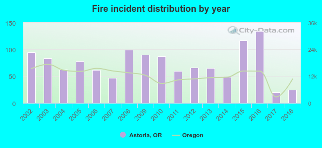 Based on the data from the years 2002 - 2018 the average number of fire incidents per year is 73. The highest number of fires - 134 took place in 2016, and the least - 20 in 2017. The data has a declining trend.
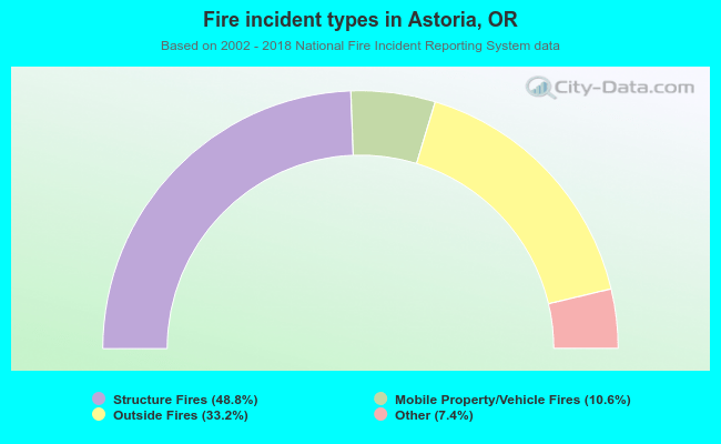 When looking into fire subcategories, the most reports belonged to: Structure Fires (48.8%), and Outside Fires (33.2%).
Fire-safe hotels and motels in Astoria, Oregon:
- Best Western Lincoln Inn Of Astoria, 555 Hamburg Ave, Astoria, Oregon 97103 , Phone: (503) 325-2205, Fax: (503) 325-5550
- Comfort Suites Columbia River, 3420 Leif Erickson Dr, Astoria, Oregon 97103 , Phone: (503) 325-2000, Fax: (503) 325-5335
- Cannery Pier Hotel, No 10 Basin St, Astoria, Oregon 97103 , Phone: (503) 325-4996, Fax: (503) 325-8350
- Hampton Inn & Suites Astoria, 201 39th St, Astoria, Oregon 97103 , Phone: (503) 325-8888, Fax: (503) 325-0111
- Hotel Elliott, 357 12th St, Astoria, Oregon 97103 , Phone: (503) 325-2222
| Most common first names in Astoria, OR among deceased individuals | ||
| Name | Count | Lived (average) |
|---|---|---|
| John | 185 | 76.4 years |
| William | 98 | 73.8 years |
| Robert | 92 | 72.5 years |
| George | 90 | 75.6 years |
| James | 82 | 73.2 years |
| Mary | 73 | 79.5 years |
| Charles | 73 | 73.5 years |
| Helen | 56 | 78.4 years |
| Henry | 54 | 79.3 years |
| Anna | 48 | 84.1 years |
| Most common last names in Astoria, OR among deceased individuals | ||
| Last name | Count | Lived (average) |
|---|---|---|
| Johnson | 108 | 78.6 years |
| Anderson | 76 | 77.8 years |
| Smith | 48 | 75.1 years |
| Carlson | 44 | 80.9 years |
| Larson | 42 | 76.3 years |
| Olson | 39 | 79.1 years |
| Peterson | 31 | 78.3 years |
| Hansen | 30 | 77.7 years |
| Nelson | 29 | 74.5 years |
| Olsen | 26 | 82.0 years |
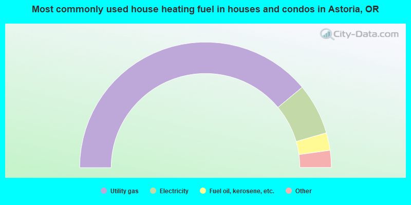
- 77.9%Utility gas
- 13.2%Electricity
- 4.5%Fuel oil, kerosene, etc.
- 2.2%Wood
- 1.7%Bottled, tank, or LP gas
- 0.4%Other fuel
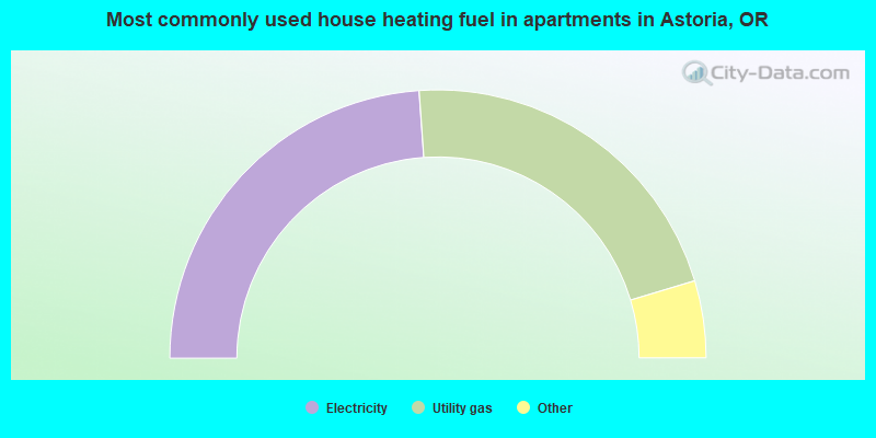
- 47.8%Electricity
- 43.0%Utility gas
- 2.9%Fuel oil, kerosene, etc.
- 1.6%Bottled, tank, or LP gas
- 1.6%Other fuel
- 1.6%No fuel used
- 1.5%Wood
Astoria compared to Oregon state average:
- Unemployed percentage below state average.
- Black race population percentage below state average.
- Median age above state average.
- Foreign-born population percentage below state average.
- Length of stay since moving in significantly above state average.
- House age above state average.
Astoria on our top lists:
- #21 on the list of "Top 101 cities with the largest percentage of people in crews of maritime vessels (population 1,000+)"
- #23 on the list of "Top 101 cities with the most users submitting photos to our site per 10,000 residents (population 5,000+)"
- #43 on the list of "Top 101 cities with the largest percentage of people in military ships (population 1,000+)"

|
|
Total of 19 patent applications in 2008-2024.