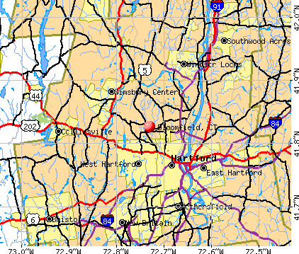
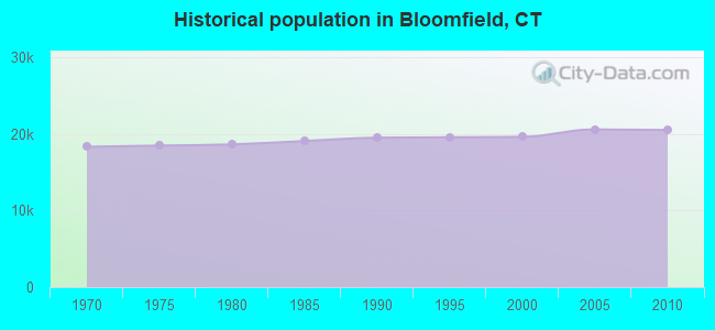
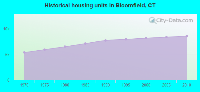
Bloomfield, Connecticut

Bloomfield: Mavi restaurant
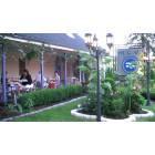
Bloomfield: Mavi restaurant

Bloomfield: Mavi restaurant

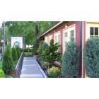
Bloomfield: BLOOMFIELD, CT - OLD FARM SCHOOL BUILT IN 1796
Bloomfield: Mavi restaurant

Bloomfield: Mavi restaurant. Top rated Mediterranean restaurant in CT. www.mavicuisine.com
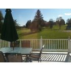
Bloomfield: TBCC GOLF COURSE FROM REAR DECK
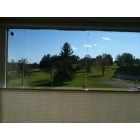
Bloomfield: VIEW OF TBCC GOLF COURSE

Bloomfield: Sunset in Bloomfield Looking Towards Talcott Mountain
- add
your
Submit your own pictures of this town and show them to the world
- OSM Map
- General Map
- Google Map
- MSN Map
Population change since 2000: +4.6%
 |
| Males: 9,199 | |
| Females: 11,287 |
| Median resident age: | 47.9 years |
| Connecticut median age: | 39.2 years |
Zip codes: 06002.
| Bloomfield: | $88,227 |
| CT: | $88,429 |
Estimated per capita income in 2022: $51,719 (it was $28,843 in 2000)
Bloomfield town income, earnings, and wages data
Estimated median house or condo value in 2022: $288,180 (it was $133,300 in 2000)
| Bloomfield: | $288,180 |
| CT: | $347,200 |
Mean prices in 2022: all housing units: $326,390; detached houses: $351,925; townhouses or other attached units: $238,893; in 2-unit structures: $226,606; in 3-to-4-unit structures: $205,937; in 5-or-more-unit structures: $157,099; mobile homes: $128,456
Detailed information about poverty and poor residents in Bloomfield, CT


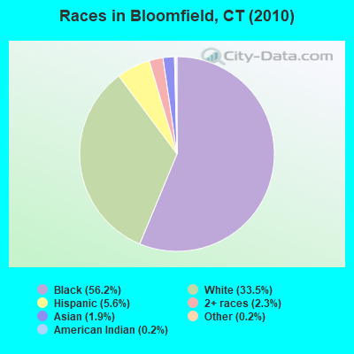
- 11,51856.2%Black alone
- 6,86333.5%White alone
- 1,1495.6%Hispanic
- 4792.3%Two or more races
- 3821.9%Asian alone
- 380.2%American Indian alone
- 490.2%Other race alone
- 80.04%Native Hawaiian and Other
Pacific Islander alone
Races in Bloomfield detailed stats: ancestries, foreign born residents, place of birth
According to our research of Connecticut and other state lists, there were 35 registered sex offenders living in Bloomfield, Connecticut as of April 27, 2024.
The ratio of all residents to sex offenders in Bloomfield is 585 to 1.
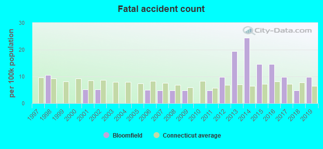
Type |
2009 |
2010 |
2011 |
2012 |
2013 |
2014 |
2015 |
2016 |
2017 |
2018 |
2019 |
2020 |
2021 |
2022 |
|---|---|---|---|---|---|---|---|---|---|---|---|---|---|---|
| Murders (per 100,000) | 1 (4.8) | 1 (4.9) | 1 (4.9) | 0 (0.0) | 1 (4.8) | 0 (0.0) | 1 (4.8) | 0 (0.0) | 0 (0.0) | 0 (0.0) | 1 (4.7) | 2 (9.4) | 2 (9.4) | 0 (0.0) |
| Rapes (per 100,000) | 12 (57.5) | 3 (14.6) | 7 (34.1) | 5 (24.3) | 9 (43.6) | 7 (33.8) | 8 (38.3) | 9 (43.3) | 10 (48.4) | 8 (37.1) | 5 (23.4) | 4 (18.8) | 4 (18.8) | 1 (4.7) |
| Robberies (per 100,000) | 13 (62.3) | 15 (73.2) | 9 (43.9) | 9 (43.8) | 10 (48.5) | 12 (57.9) | 8 (38.3) | 11 (52.9) | 10 (48.4) | 13 (60.4) | 5 (23.4) | 18 (84.5) | 11 (51.8) | 8 (37.3) |
| Assaults (per 100,000) | 24 (115.1) | 23 (112.3) | 29 (141.3) | 18 (87.6) | 27 (130.8) | 21 (101.4) | 42 (200.9) | 32 (153.8) | 16 (77.4) | 43 (199.6) | 16 (74.7) | 12 (56.4) | 23 (108.2) | 9 (41.9) |
| Burglaries (per 100,000) | 108 (517.8) | 86 (419.8) | 95 (462.9) | 73 (355.1) | 52 (252.0) | 90 (434.4) | 67 (320.6) | 54 (259.6) | 48 (232.3) | 35 (162.5) | 21 (98.1) | 32 (150.3) | 25 (117.6) | 34 (158.4) |
| Thefts (per 100,000) | 386 (1,851) | 437 (2,133) | 400 (1,949) | 415 (2,019) | 411 (1,992) | 402 (1,940) | 423 (2,024) | 423 (2,034) | 468 (2,264) | 483 (2,242) | 434 (2,027) | 454 (2,132) | 476 (2,240) | 577 (2,689) |
| Auto thefts (per 100,000) | 31 (148.6) | 23 (112.3) | 32 (155.9) | 34 (165.4) | 22 (106.6) | 22 (106.2) | 25 (119.6) | 43 (206.7) | 69 (333.9) | 66 (306.4) | 48 (224.2) | 65 (305.3) | 54 (254.1) | 36 (167.7) |
| Arson (per 100,000) | 1 (4.8) | 2 (9.8) | 3 (14.6) | 0 (0.0) | 1 (4.8) | 1 (4.8) | 0 (0.0) | 4 (19.2) | 7 (33.9) | 1 (4.6) | 0 (0.0) | 1 (4.7) | 2 (9.4) | 2 (9.3) |
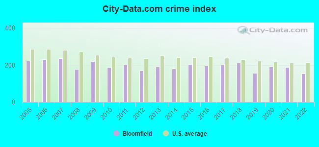
| City-Data.com crime index | 219.5 | 189.6 | 201.3 | 168.9 | 191.1 | 181.2 | 204.8 | 197.3 | 202.3 | 213.3 | 155.9 | 190.7 | 189.2 | 155.4 |
The City-Data.com crime index weighs serious crimes and violent crimes more heavily. Higher means more crime, U.S. average is 246.1. It adjusts for the number of visitors and daily workers commuting into cities.
Crime rate in Bloomfield detailed stats: murders, rapes, robberies, assaults, burglaries, thefts, arson
Full-time law enforcement employees in 2021, including police officers: 59 (46 officers - 34 male; 12 female).
| Officers per 1,000 residents here: | 2.16 |
| Connecticut average: | 2.10 |
 Recent articles from our blog. Our writers, many of them Ph.D. graduates or candidates, create easy-to-read articles on a wide variety of topics.

Latest news from Bloomfield, CT collected exclusively by city-data.com from local newspapers, TV, and radio stations
Bloomfield, CT City Guides:
Ancestries: West Indian (16.0%), English (7.7%), Irish (6.4%), German (5.5%), Italian (4.7%), Polish (3.3%).
Current Local Time: EST time zone
Incorporated on 05/1835
Elevation: 121 feet
Land area: 26.0 square miles.
Population density: 788 people per square mile (low).
3,513 residents are foreign born (14.2% Latin America).
| This town: | 17.9% |
| Connecticut: | 10.9% |
| Bloomfield town: | 2.1% ($2,781) |
| Connecticut: | 1.8% ($2,961) |
Nearest city with pop. 50,000+: West Hartford, CT  (5.1 miles , pop. 63,589).
Nearest city with pop. 200,000+: North Hempstead, NY (87.9 miles , pop. 222,611).
Nearest city with pop. 1,000,000+: Bronx, NY (90.5 miles , pop. 1,332,650).
Nearest cities:
), ), )Latitude: 41.83 N, Longitude: 72.73 W
Area code commonly used in this area: 860

Bloomfield, Connecticut accommodation & food services, waste management - Economy and Business Data
Single-family new house construction building permits:
- 2021: 4 buildings, average cost: $145,600
- 2020: 15 buildings, average cost: $133,900
- 2019: 16 buildings, average cost: $147,200
- 2018: 5 buildings, average cost: $192,400
- 2017: 3 buildings, average cost: $188,700
- 2016: 28 buildings, average cost: $127,800
- 2015: 16 buildings, average cost: $138,700
- 2014: 2 buildings, average cost: $164,400
- 2013: 27 buildings, average cost: $155,500
- 2012: 25 buildings, average cost: $185,100
- 2011: 24 buildings, average cost: $181,000
- 2010: 23 buildings, average cost: $175,800
- 2009: 19 buildings, average cost: $171,200
- 2008: 48 buildings, average cost: $225,900
- 2007: 49 buildings, average cost: $214,100
- 2006: 99 buildings, average cost: $185,500
- 2005: 71 buildings, average cost: $157,700
- 2004: 96 buildings, average cost: $104,400
- 2003: 63 buildings, average cost: $127,500
- 2002: 61 buildings, average cost: $110,200
- 2001: 40 buildings, average cost: $90,100
- 2000: 33 buildings, average cost: $79,600
- 1999: 40 buildings, average cost: $74,000
- 1998: 37 buildings, average cost: $77,200
- 1997: 33 buildings, average cost: $69,100
| Here: | 4.3% |
| Connecticut: | 3.9% |
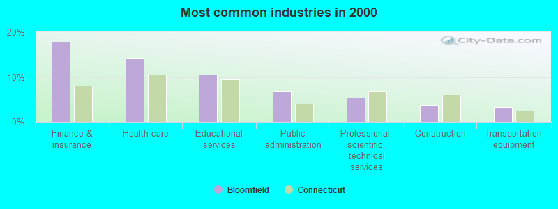
- Finance & insurance (17.8%)
- Health care (14.3%)
- Educational services (10.6%)
- Public administration (6.9%)
- Professional, scientific, technical services (5.4%)
- Construction (3.7%)
- Transportation equipment (3.2%)
- Finance & insurance (13.7%)
- Educational services (8.3%)
- Construction (7.1%)
- Health care (6.7%)
- Public administration (6.3%)
- Transportation equipment (5.3%)
- Professional, scientific, technical services (5.1%)
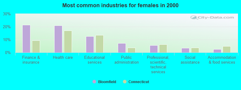
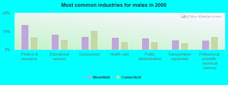
- Finance & insurance (21.3%)
- Health care (20.9%)
- Educational services (12.5%)
- Public administration (7.3%)
- Professional, scientific, technical services (5.6%)
- Social assistance (3.5%)
- Accommodation & food services (2.6%)
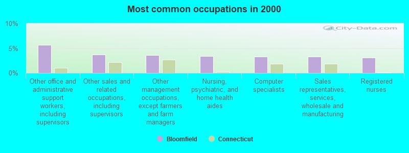
- Other office and administrative support workers, including supervisors (5.7%)
- Other sales and related occupations, including supervisors (3.7%)
- Other management occupations, except farmers and farm managers (3.6%)
- Nursing, psychiatric, and home health aides (3.4%)
- Computer specialists (3.3%)
- Sales representatives, services, wholesale and manufacturing (3.3%)
- Registered nurses (3.1%)
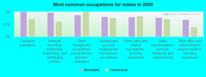
- Computer specialists (5.0%)
- Material recording, scheduling, dispatching, and distributing workers (4.9%)
- Other management occupations, except farmers and farm managers (4.4%)
- Building and grounds cleaning and maintenance occupations (4.0%)
- Other sales and related occupations, including supervisors (3.9%)
- Sales representatives, services, wholesale and manufacturing (3.8%)
- Other office and administrative support workers, including supervisors (3.4%)
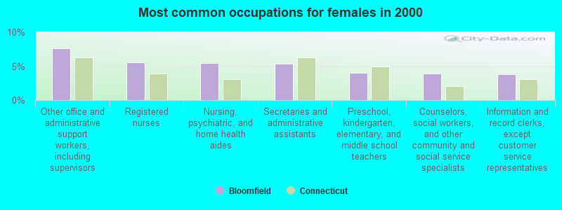
- Other office and administrative support workers, including supervisors (7.6%)
- Registered nurses (5.6%)
- Nursing, psychiatric, and home health aides (5.4%)
- Secretaries and administrative assistants (5.3%)
- Preschool, kindergarten, elementary, and middle school teachers (4.0%)
- Counselors, social workers, and other community and social service specialists (3.9%)
- Information and record clerks, except customer service representatives (3.8%)
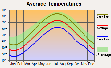
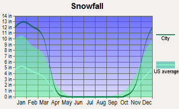
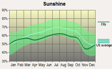
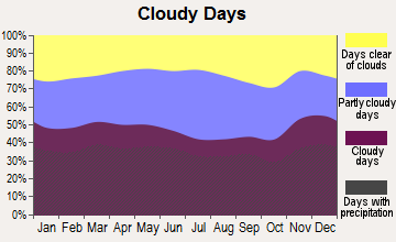
Average climate in Bloomfield, Connecticut
Based on data reported by over 4,000 weather stations
(lower is better)
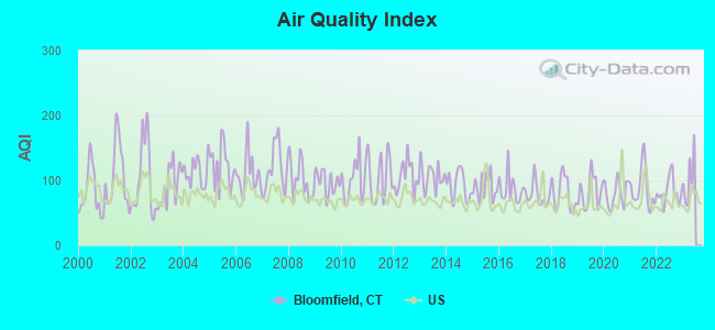
Air Quality Index (AQI) level in 2022 was 82.0. This is about average.
| City: | 82.0 |
| U.S.: | 72.6 |
Carbon Monoxide (CO) [ppm] level in 2022 was 0.312. This is worse than average. Closest monitor was 4.9 miles away from the city center.
| City: | 0.312 |
| U.S.: | 0.251 |
Nitrogen Dioxide (NO2) [ppb] level in 2022 was 11.0. This is significantly worse than average. Closest monitor was 4.9 miles away from the city center.
| City: | 11.0 |
| U.S.: | 5.1 |
Sulfur Dioxide (SO2) [ppb] level in 2022 was 0.141. This is significantly better than average. Closest monitor was 5.4 miles away from the city center.
| City: | 0.141 |
| U.S.: | 1.515 |
Ozone [ppb] level in 2022 was 28.0. This is about average. Closest monitor was 3.6 miles away from the city center.
| City: | 28.0 |
| U.S.: | 33.3 |
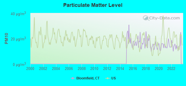
Particulate Matter (PM10) [µg/m3] level in 2022 was 14.0. This is better than average. Closest monitor was 4.9 miles away from the city center.
| City: | 14.0 |
| U.S.: | 19.2 |
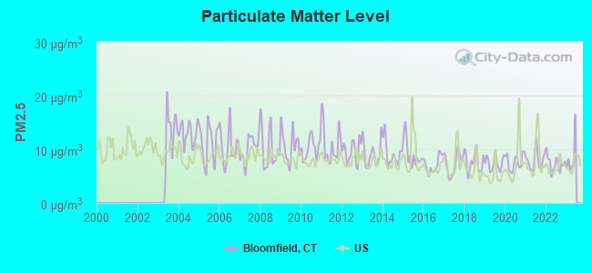
Particulate Matter (PM2.5) [µg/m3] level in 2022 was 7.30. This is about average. Closest monitor was 4.9 miles away from the city center.
| City: | 7.30 |
| U.S.: | 8.11 |
Tornado activity:
Bloomfield-area historical tornado activity is slightly above Connecticut state average. It is 16% smaller than the overall U.S. average.
On 10/3/1979, a category F4 (max. wind speeds 207-260 mph) tornado 4.4 miles away from the Bloomfield town center killed 3 people and injured 500 people and caused between $50,000,000 and $500,000,000 in damages.
On 7/10/1989, a category F4 tornado 32.6 miles away from the town center injured 40 people and caused between $50,000,000 and $500,000,000 in damages.
Earthquake activity:
Bloomfield-area historical earthquake activity is significantly above Connecticut state average. It is 70% smaller than the overall U.S. average.On 10/7/1983 at 10:18:46, a magnitude 5.3 (5.1 MB, 5.3 LG, 5.1 ML, Class: Moderate, Intensity: VI - VII) earthquake occurred 167.9 miles away from the city center
On 4/20/2002 at 10:50:47, a magnitude 5.3 (5.3 ML, Depth: 3.0 mi) earthquake occurred 191.7 miles away from Bloomfield center
On 4/20/2002 at 10:50:47, a magnitude 5.2 (5.2 MB, 4.2 MS, 5.2 MW, 5.0 MW) earthquake occurred 190.3 miles away from the city center
On 1/19/1982 at 00:14:42, a magnitude 4.7 (4.5 MB, 4.7 MD, 4.5 LG, Class: Light, Intensity: IV - V) earthquake occurred 128.8 miles away from the city center
On 10/16/2012 at 23:12:25, a magnitude 4.7 (4.7 ML, Depth: 10.0 mi) earthquake occurred 161.1 miles away from Bloomfield center
On 8/23/2011 at 17:51:04, a magnitude 5.8 (5.8 MW, Depth: 3.7 mi) earthquake occurred 387.3 miles away from the city center
Magnitude types: regional Lg-wave magnitude (LG), body-wave magnitude (MB), duration magnitude (MD), local magnitude (ML), surface-wave magnitude (MS), moment magnitude (MW)
Natural disasters:
The number of natural disasters in Hartford County (24) is greater than the US average (15).Major Disasters (Presidential) Declared: 13
Emergencies Declared: 11
Causes of natural disasters: Storms: 7, Hurricanes: 5, Floods: 4, Snowstorms: 4, Blizzards: 3, Snows: 3, Tropical Storms: 2, Winter Storms: 2, Snowfall: 1, Tornado: 1, Wind: 1 (Note: some incidents may be assigned to more than one category).

Main business address for: KAMAN CORP (WHOLESALE-MACHINERY, EQUIPMENT & SUPPLIES).
Hospitals in Bloomfield:
Nursing Homes in Bloomfield:
- ALEXANDRIA MANOR (55 TUNXIS AVE)
- BLOOMFIELD HEALTH CARE CENTER (355 PARK AVENUE)
- BLOOMFIELD MANOR (160 COVENTRY GARDENS)
- CALEB HITCHCOCK HEALTH CARE CE (40 LOEFFLER RD)
- SEABURY RETIREMENT COMMUNITY (200 SEABURY DRIVE)
- WINTONBURY CARE CENTER, LLC (140 PARK AVE)
- WINTONBURY MANOR (140 PARK AVE)
Dialysis Facilities in Bloomfield:
Home Health Centers in Bloomfield:
Heliports located in Bloomfield:
Amtrak stations near Bloomfield:
- 5 miles: WINDSOR (41 CENTRAL ST.) . Services: enclosed waiting area, public restrooms, public payphones, free short-term parking, call for car rental service, call for taxi service, public transit connection.
- 6 miles: HARTFORD (1 UNION PLACE) . Services: ticket office, partially wheelchair accessible, enclosed waiting area, public restrooms, public payphones, full-service food facilities, snack bar, vending machines, ATM, paid short-term parking, paid long-term parking, call for car rental service, taxi stand, intercity bus service, public transit connection.
- 9 miles: WINDSOR LOCKS (S. MAIN ST. (RTE. 159)) . Services: public payphones, free short-term parking, free long-term parking, call for car rental service, call for taxi service, public transit connection.
Colleges/universities with over 2000 students nearest to Bloomfield:
- University of Hartford (about 3 miles; West Hartford, CT; Full-time enrollment: 6,398)
- Capital Community College (about 6 miles; Hartford, CT; FT enrollment: 2,609)
- Trinity College (about 7 miles; Hartford, CT; FT enrollment: 2,355)
- Goodwin College (about 8 miles; East Hartford, CT; FT enrollment: 3,017)
- Manchester Community College (about 10 miles; Manchester, CT; FT enrollment: 4,667)
- Central Connecticut State University (about 11 miles; New Britain, CT; FT enrollment: 9,989)
- Tunxis Community College (about 12 miles; Farmington, CT; FT enrollment: 2,787)
Public high schools in Bloomfield:
- BLOOMFIELD HIGH SCHOOL (Students: 559, Location: 5 HUCKLEBERRY LANE, Grades: 9-12)
- GLOBAL EXPERIENCE MAGNET SCHOOL (Location: 44 GRIFFIN ROAD SOUTH, Grades: 6-12)
- LEARNING ACADEMY AT BLOOMFIELD (Location: 34 EAST DUDLEY TOWN ROAD, Grades: 9-12)
- METROPOLITAN LEARNING CENTER FOR GLOBAL AND INTERN (Location: 1551 BLUE HILLS AVENUE, Grades: 6-12)
- PATHWAYS ACADEMY OF TECHNOLOGY AND DESIGN (Location: 1551 BLUE HILLS AVENUE, Grades: 9-12)
Public elementary/middle schools in Bloomfield:
- CARMEN ARACE INTERMEDIATE SCHOOL (Students: 364, Location: 390 PARK AVENUE, Grades: 5-6)
- CARMEN ARACE MIDDLE SCHOOL (Students: 350, Location: 390 PARK AVENUE, Grades: 7-8)
- LAUREL ELEMENTARY SCHOOL (Students: 314, Location: ONE FILLEY STREET, Grades: KG-2)
- METACOMET SCHOOL (Students: 270, Location: 185 SCHOOL STREET, Grades: 3-4)
- MUSEUM ACADEMY (Location: 11 TURKEY HILL ROAD, Grades: PK-5)
- ANA GRACE ACADEMY OF THE ARTS ELEMENTARY SCHOOL (Location: 206 WEST NEWBURY ROAD, Grades: PK-2)
Private elementary/middle school in Bloomfield:
Library in Bloomfield:
- PROSSER PUBLIC LIBRARY (Operating income: $1,314,519; Location: 1 TUNXIS AVE.; 111,569 books; 18 e-books; 6,696 audio materials; 11,090 video materials; 2 local licensed databases; 30 state licensed databases; 2 other licensed databases; 155 print serial subscriptions; 1 electronic serial subscriptions)
Points of interest:
Notable locations in Bloomfield: Blue Hills Industrial Park (A), Tumble Brook Country Club (B), Bloomfield Fire Department Company 2 (C), Prosser Public Library (D), Wintonbury Building (E), Bloomfield Fire Department Company 1 (F), Blue Hills Fire Department Station 4 (G), Blue Hills Fire Department Station 3 (H), Blue Hills Fire Department Station 1 Headquarters (I), Bloomfield Fire Department Company 3 (J), Archbishop Henry O'Brien Library (K), Bloomfield Volunteer Ambulance Service (L). Display/hide their locations on the map
Shopping Centers: Bloomfield Shopping Center (1), Tunxis Plaza Shopping Center (2), The Center of Bloomfield Shopping Center (3), Copacos Shopping Center (4). Display/hide their locations on the map
Main business address in Bloomfield: KAMAN CORP (A). Display/hide its location on the map
Churches in Bloomfield include: Saint Andrews Church (A), Beth Hillel Synagogue (B), Bethel African Methodist Episcopal Church (C), Bloomfield United Methodist Church (D), Brothers of the Sacred Heart Church (E), Christ the King Church (F), First Congregational Church (G), Sacred Heart Parish Church (H), Saint Johns Full Gospel Deliverance Church (I). Display/hide their locations on the map
Cemeteries: Saint Andrews Cemetery (1), Old Wintonbury Cemetery (2), Latimer Hill Cemetery (3), Mount Saint Benedict Cemetery (4), Mountain View Cemetery (5). Display/hide their locations on the map
Lakes and reservoirs: Gale Pond (A), Lake Louise (B), Barber Pond (C), Bloomfield Reservoir (D), Bloomfield Reservoir 3A (E), Wintonbury Reservoir (F), Cold Spring Reservoir (G), Blue Hills Reservoir (H). Display/hide their locations on the map
Streams, rivers, and creeks: Beamans Brook (A), Wash Brook (B), Tumble Brook (C), Griffin Brook (D). Display/hide their locations on the map
Parks in Bloomfield include: Bloomfield Town Green (1), Filley Park (2), Hubbard Street Tot Lot (3), Mill Brook State Park (4), Pershing Park Playground (5), West Eggleston Street Tot Lot (6), Marion K Wilcox Park (7), Penwood State Park (8), North Branch State Access Area (9). Display/hide their locations on the map
Court: Bloomfield Town - Probate Court (800 Bloomfield Avenue) (1). Display/hide its approximate location on the map
Birthplace of: Anika Noni Rose - Actor, David Ushery - Television journalist, Ferdiand Cain - College basketball player (Char. Southern Buccaneers), Francis Gillette - Politician, Leeshan Reid - College basketball player (Connecticut Huskies), Nykesha Sales - WNBA player (Connecticut Sun, born: May 10, 1976).
Drinking water stations with addresses in Bloomfield and their reported violations in the past:
JUNIPER CLUB INC. (Population served: 104, Groundwater):Past health violations:SHARON HEIGHTS WATER ASSOCIATION (Address: 41 SHARON ROAD , Population served: 51, Groundwater):
- MCL, Monthly (TCR) - In AUG-2010, Contaminant: Coliform. Follow-up actions: St Public Notif requested (SEP-13-2010), St Violation/Reminder Notice (SEP-13-2010), St Public Notif received (SEP-21-2010), St Compliance achieved (SEP-30-2010)
- MCL, Monthly (TCR) - In SEP-2008, Contaminant: Coliform. Follow-up actions: St Public Notif requested (OCT-06-2008), St Violation/Reminder Notice (OCT-06-2008), St Public Notif received (OCT-29-2008), St Compliance achieved (OCT-31-2008), St Public Notif received (JAN-31-2010)
- MCL, Acute (TCR) - In JUL-2007, Contaminant: Coliform. Follow-up actions: St Public Notif received (JUL-17-2007), St Public Notif requested (JUL-31-2007), St Violation/Reminder Notice (JUL-31-2007), St Compliance achieved (MAR-31-2008)
- MCL, Monthly (TCR) - In JUL-2007, Contaminant: Coliform. Follow-up actions: St Public Notif received (JUL-17-2007), St Public Notif requested (JUL-31-2007), St Violation/Reminder Notice (JUL-31-2007), St Compliance achieved (MAR-31-2008)
- MCL, Monthly (TCR) - In JUN-2007, Contaminant: Coliform. Follow-up actions: St Public Notif requested (JUN-14-2007), St Violation/Reminder Notice (JUN-14-2007), St Public Notif received (JUL-17-2007), St Compliance achieved (MAR-31-2008)
- MCL, Acute (TCR) - In JUN-2007, Contaminant: Coliform. Follow-up actions: St Public Notif requested (JUN-14-2007), St Violation/Reminder Notice (JUN-14-2007), St Public Notif received (JUL-17-2007), St Compliance achieved (MAR-31-2008)
- 4 other older health violations
Past monitoring violations:ORCHARD HILL ASSOCIATION (Population served: 30, Groundwater):
- Follow-up Or Routine LCR Tap M/R - In OCT-01-2009, Contaminant: Lead and Copper Rule. Follow-up actions: St Violation/Reminder Notice (FEB-26-2010), St Compliance achieved (MAR-03-2010)
- 91 regular monitoring violations
Past monitoring violations:
- 4 routine major monitoring violations
- 6 regular monitoring violations
Drinking water stations with addresses in Bloomfield that have no violations reported:
- GRANT HILL ASSOCIATES, INC. (Population served: 97, Primary Water Source Type: Groundwater)
| This town: | 2.3 people |
| Connecticut: | 2.5 people |
| This town: | 62.5% |
| Whole state: | 66.3% |
| This town: | 5.3% |
| Whole state: | 6.6% |
Likely homosexual households (counted as self-reported same-sex unmarried-partner households)
- Lesbian couples: 0.8% of all households
- Gay men: 0.4% of all households
| This town: | 7.6% |
| Whole state: | 7.9% |
| This town: | 2.5% |
| Whole state: | 3.9% |
People in group quarters in Bloomfield in 2010:
- 473 people in nursing facilities/skilled-nursing facilities
- 54 people in correctional residential facilities
- 52 people in other noninstitutional facilities
- 39 people in group homes intended for adults
- 11 people in group homes for juveniles (non-correctional)
- 6 people in residential treatment centers for adults
People in group quarters in Bloomfield in 2000:
- 491 people in nursing homes
- 24 people in homes for the mentally ill
- 17 people in religious group quarters
- 15 people in homes for the mentally retarded
- 6 people in other group homes
Banks with branches in Bloomfield (2011 data):
- People's United Bank: Seabury Retirement Branch, Bloomfield Super Stop & Shop, Duncaster Branch. Info updated 2012/02/16: Bank assets: $27,319.3 mil, Deposits: $20,835.4 mil, headquarters in Bridgeport, CT, positive income, Commercial Lending Specialization, 374 total offices
- Wells Fargo Bank, National Association: Bloomfield Branch at 44 Jerome Avenue, branch established on 1972/09/18. Info updated 2011/04/05: Bank assets: $1,161,490.0 mil, Deposits: $905,653.0 mil, headquarters in Sioux Falls, SD, positive income, 6395 total offices, Holding Company: Wells Fargo & Company
- The Simsbury Bank & Trust Company: Bloomfield Office Branch at 864 Cottage Grove Road, branch established on 2006/06/13. Info updated 2010/09/29: Bank assets: $376.9 mil, Deposits: $344.9 mil, headquarters in Simsbury, CT, positive income, 5 total offices, Holding Company: Sbt Bancorp, Inc.
- Bank of America, National Association: Bloomfield Branch at 836 Park Avenue, branch established on 1957/01/14. Info updated 2009/11/18: Bank assets: $1,451,969.3 mil, Deposits: $1,077,176.8 mil, headquarters in Charlotte, NC, positive income, 5782 total offices, Holding Company: Bank Of America Corporation
- Webster Bank, National Association: Bloomfield Branch at 275 Cottage Grove Road, branch established on 1962/02/01. Info updated 2008/12/23: Bank assets: $18,674.3 mil, Deposits: $13,861.5 mil, headquarters in Waterbury, CT, positive income, Commercial Lending Specialization, 167 total offices, Holding Company: Webster Financial Corporation
- Windsor Federal Savings and Loan Association: Bloomfield Branch at 48 Jerome Avenue, branch established on 1979/06/18. Info updated 2011/07/21: Bank assets: $393.3 mil, Deposits: $309.8 mil, headquarters in Windsor, CT, positive income, Mortgage Lending Specialization, 5 total offices
For population 15 years and over in Bloomfield:
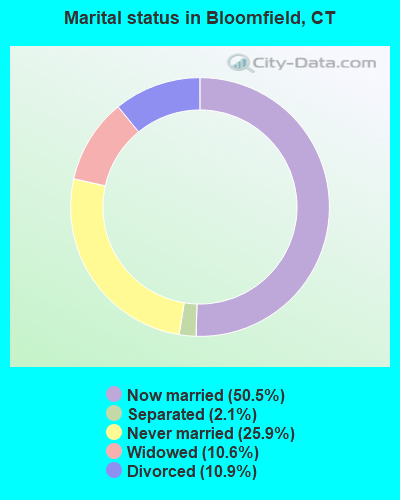
- Never married: 25.9%
- Now married: 50.5%
- Separated: 2.1%
- Widowed: 10.6%
- Divorced: 10.9%
For population 25 years and over in Bloomfield:
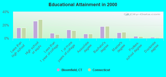
- High school or higher: 84.2%
- Bachelor's degree or higher: 30.8%
- Graduate or professional degree: 13.1%
- Unemployed: 5.4%
- Mean travel time to work (commute): 23.2 minutes
| Here: | 12.4 |
| Connecticut average: | 12.8 |
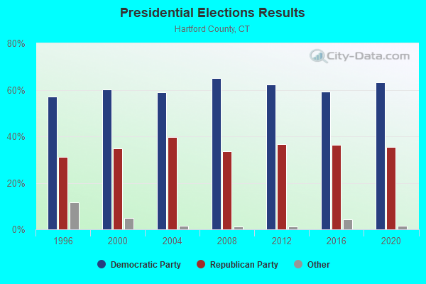
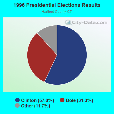
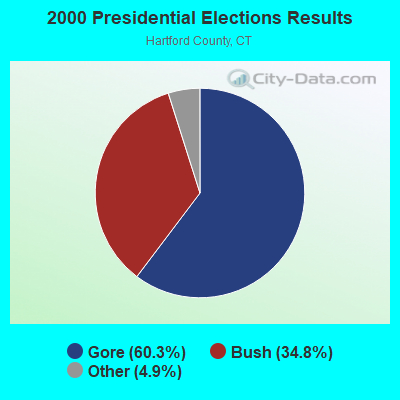
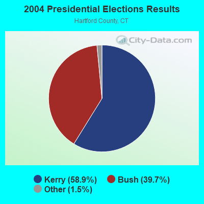
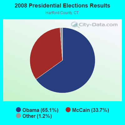
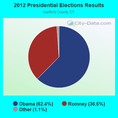
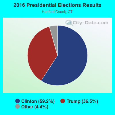
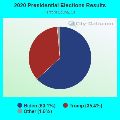
Graphs represent county-level data. Detailed 2008 Election Results
Religion statistics for Bloomfield, CT (based on Hartford County data)
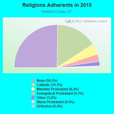
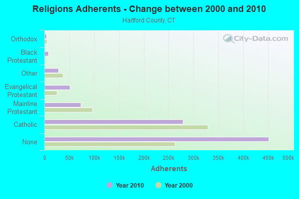
| Religion | Adherents | Congregations |
|---|---|---|
| Catholic | 278,203 | 100 |
| Mainline Protestant | 73,522 | 183 |
| Evangelical Protestant | 50,619 | 214 |
| Other | 28,183 | 94 |
| Black Protestant | 8,446 | 26 |
| Orthodox | 3,665 | 13 |
| None | 451,376 | - |
Food Environment Statistics:
| Hartford County: | 2.46 / 10,000 pop. |
| Connecticut: | 2.21 / 10,000 pop. |
| This county: | 0.06 / 10,000 pop. |
| State: | 0.07 / 10,000 pop. |
| Hartford County: | 1.05 / 10,000 pop. |
| Connecticut: | 1.02 / 10,000 pop. |
| Hartford County: | 2.32 / 10,000 pop. |
| State: | 2.27 / 10,000 pop. |
| Here: | 8.63 / 10,000 pop. |
| State: | 9.19 / 10,000 pop. |
| This county: | 7.4% |
| Connecticut: | 7.3% |
| Hartford County: | 22.1% |
| Connecticut: | 21.5% |
| This county: | 16.0% |
| State: | 15.8% |
4.94% of this county's 2021 resident taxpayers lived in other counties in 2020 ($69,891 average adjusted gross income)
| Here: | 4.94% |
| Connecticut average: | 5.79% |
0.04% of residents moved from foreign countries ($102 average AGI)
Hartford County: 0.04% Connecticut average: 0.02%
Top counties from which taxpayers relocated into this county between 2020 and 2021:
| from New Haven County, CT | |
| from Tolland County, CT | |
| from Middlesex County, CT |
5.15% of this county's 2020 resident taxpayers moved to other counties in 2021 ($92,529 average adjusted gross income)
| Here: | 5.15% |
| Connecticut average: | 5.82% |
0.03% of residents moved to foreign countries ($235 average AGI)
Hartford County: 0.03% Connecticut average: 0.02%
Top counties to which taxpayers relocated from this county between 2020 and 2021:
| to Tolland County, CT | |
| to New Haven County, CT | |
| to Middlesex County, CT |
| Businesses in Bloomfield, CT | ||||
| Name | Count | Name | Count | |
|---|---|---|---|---|
| Advance Auto Parts | 1 | Lowe's | 1 | |
| AutoZone | 1 | McDonald's | 1 | |
| Avenue | 1 | Nike | 3 | |
| Burger King | 1 | Payless | 1 | |
| Burlington Coat Factory | 1 | RadioShack | 1 | |
| CVS | 2 | Rite Aid | 1 | |
| Dunkin Donuts | 4 | Ruby Tuesday | 1 | |
| FedEx | 5 | Starbucks | 1 | |
| Firestone Complete Auto Care | 1 | Stop & Shop | 1 | |
| GNC | 1 | Subway | 2 | |
| GameStop | 1 | T-Mobile | 1 | |
| H&R Block | 1 | U-Haul | 1 | |
| Home Depot | 1 | UPS | 5 | |
| IHOP | 1 | Vans | 1 | |
| KFC | 1 | Wendy's | 1 | |
| La-Z-Boy | 1 | |||
Strongest AM radio stations in Bloomfield:
- WTIC (1080 AM; 50 kW; HARTFORD, CT; Owner: INFINITY RADIO OPERATIONS INC.)
- WDRC (1360 AM; 5 kW; HARTFORD, CT; Owner: BUCKLEY BROADCASTING CORPORATION)
- WDZK (1550 AM; 5 kW; BLOOMFIELD, CT; Owner: ABC, INC.)
- WNNZ (640 AM; 50 kW; WESTFIELD, MA; Owner: CLEAR CHANNEL BROADCASTING LICENSES, INC.)
- WLAT (910 AM; 5 kW; NEW BRITAIN, CT; Owner: MEGA COMMUNICATIONS OF NEW BRITAIN LICENSEE, LLC)
- WKND (1480 AM; 0 kW; WINDSOR, CT; Owner: HARTCOM, INC.)
- WPOP (1410 AM; 5 kW; HARTFORD, CT; Owner: CAPSTAR TX LIMITED PARTNERSHIP)
- WTMI (1290 AM; 1 kW; WEST HARTFORD, CT; Owner: MARLIN BROADCASTING, LLC)
- WCRN (830 AM; 50 kW; WORCESTER, MA; Owner: CARTER BROADCASTING CORPORATION)
- WVNE (760 AM; daytime; 25 kW; LEICESTER, MA; Owner: BLOUNT MASSCOM, INC.)
- WALE (990 AM; 50 kW; GREENVILLE, RI; Owner: NORTH AMERICAN BROADCASTING CO., INC.)
- WHYN (560 AM; 5 kW; SPRINGFIELD, MA; Owner: CLEAR CHANNEL BROADCASTING LICENSES, INC.)
- WACE (730 AM; 5 kW; CHICOPEE, MA; Owner: CARTER BROADCASTING CORP.)
Strongest FM radio stations in Bloomfield:
- WCCC-FM (106.9 FM; HARTFORD, CT; Owner: MARLIN BROADCASTING, LLC)
- WTIC-FM (96.5 FM; HARTFORD, CT; Owner: INFINITY RADIO OPERATIONS INC.)
- WWUH (91.3 FM; WEST HARTFORD, CT; Owner: UNIVERSITY OF HARTFORD)
- WRCH (100.5 FM; NEW BRITAIN, CT; Owner: INFINITY RADIO OPERATIONS INC.)
- WQTQ (89.9 FM; HARTFORD, CT; Owner: HARTFORD BOARD OF EDUCATION)
- WAQY (102.1 FM; SPRINGFIELD, MA; Owner: SAGA COMMUNICATIONS OF NEW ENGLAND, LLC)
- WJMJ (88.9 FM; HARTFORD, CT; Owner: ST. THOMAS SEMINARY)
- WWYZ (92.5 FM; WATERBURY, CT; Owner: CAPSTAR TX LIMITED PARTNERSHIP)
- WKSS (95.7 FM; HARTFORD-MERIDEN, CT; Owner: CAPSTAR TX LIMITED PARTNERSHIP)
- WHCN (105.9 FM; HARTFORD, CT; Owner: CAPSTAR TX LIMITED PARTNERSHIP)
- WZMX (93.7 FM; HARTFORD, CT; Owner: INFINITY RADIO OPERATIONS INC.)
- WMRQ (104.1 FM; WATERBURY, CT; Owner: CAPSTAR TX LIMITED PARTNERSHIP)
- WPKT (90.5 FM; MERIDEN, CT; Owner: CONNECTICUT PUBLIC BROADCASTING, INC)
- WDRC-FM (102.9 FM; HARTFORD, CT; Owner: BUCKLEY BROADCASTING CORPORATION)
- WPKX (97.9 FM; ENFIELD, CT; Owner: CAPSTAR TX LIMITED PARTNERSHIP)
- WKCI-FM (101.3 FM; HAMDEN, CT; Owner: CLEAR CHANNEL BROADCASTING LICENSES, INC.)
- WHYN-FM (93.1 FM; SPRINGFIELD, MA; Owner: CLEAR CHANNEL BROADCASTING LICENSES, INC.)
- WRNX (100.9 FM; AMHERST, MA; Owner: WESTERN MASSACHUSETTS RADIO COMPANY)
- WPLR (99.1 FM; NEW HAVEN, CT; Owner: COX RADIO, INC.)
- WRTC-FM (89.3 FM; HARTFORD, CT; Owner: TRUSTEES OF TRINITY COLLEGE)
TV broadcast stations around Bloomfield:
- WUVN (Channel 18; HARTFORD, CT; Owner: ENTRAVISION HOLDINGS, LLC)
- WTIC-TV (Channel 61; HARTFORD, CT; Owner: TRIBUNE TELEVISION COMPANY)
- W11BJ (Channel 11; HARTFORD, CT; Owner: COMMUNICATIONS SITE MANAGEMENT LLC)
- WFSB (Channel 3; HARTFORD, CT; Owner: MEREDITH CORPORATION)
- WTXX (Channel 20; WATERBURY, CT; Owner: WTXX INC.)
- WHCT-LP (Channel 38; HARTFORD, CT; Owner: VENTURE TECHNOLOGIES GROUP, LLC)
- WVIT (Channel 30; NEW BRITAIN, CT; Owner: OUTLET BROADCASTING, INC)
- WEDH (Channel 24; HARTFORD, CT; Owner: CONNECTICUT PUBLIC BROADCASTING, INC.)
- WHTX-LP (Channel 10; HARTFORD, CT; Owner: ENTRAVISION HOLDINGS, LLC)
- WRDM-LP (Channel 13; HARTFORD, CT; Owner: ZGS HARTFORD, INC.)
- WMLD-LP (Channel 6; HARTFORD, CT; Owner: HARVARD BROADCASTING, INC.)
- WYDN (Channel 48; WORCESTER, MA; Owner: EDUCATIONAL PUBLIC TV CORPORATION)
- WWLP (Channel 22; SPRINGFIELD, MA; Owner: WWLP BROADCASTING, LLC)
- WUTH-CA (Channel 47; HARTFORD, CT; Owner: ENTRAVISION HOLDINGS, LLC)
- WTNH (Channel 8; NEW HAVEN, CT; Owner: WTNH BROADCASTING, INC.)
- WHPX (Channel 26; NEW LONDON, CT; Owner: PAXSON HARTFORD LICENSE, INC.)
- WCTX (Channel 59; NEW HAVEN, CT; Owner: WTNH BROADCASTING, INC.)
- WEDY (Channel 65; NEW HAVEN, CT; Owner: CONNECTICUT PUBLIC BROADCASTING, INC.)
- W67DF (Channel 67; SPRINGFIELD, MA; Owner: TRINITY BROADCASTING NETWORK)
- WDMR-LP (Channel 65; SPRINGFIELD, MA; Owner: ZGS HARTFORD, INC.)
- W12CL (Channel 12; GRANBY, CT; Owner: SALVATORE MINNITI)
- National Bridge Inventory (NBI) Statistics
- 17Number of bridges
- 125ft / 37.8mTotal length
- $1,325,000Total costs
- 179,497Total average daily traffic
- 7,656Total average daily truck traffic
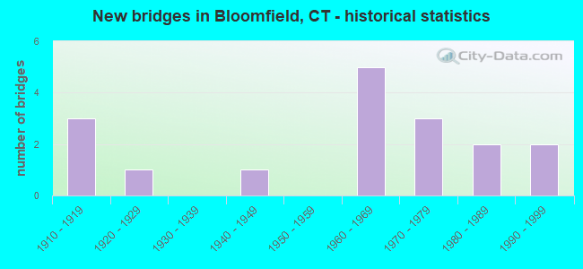
- New bridges - historical statistics
- 31910-1919
- 11920-1929
- 11940-1949
- 51960-1969
- 31970-1979
- 21980-1989
- 21990-1999
FCC Registered Private Land Mobile Towers: 1 (See the full list of FCC Registered Private Land Mobile Towers in Bloomfield, CT)
FCC Registered Broadcast Land Mobile Towers: 38 (See the full list of FCC Registered Broadcast Land Mobile Towers)
FCC Registered Microwave Towers: 21 (See the full list of FCC Registered Microwave Towers in this town)
FCC Registered Paging Towers: 4 (See the full list of FCC Registered Paging Towers)
FCC Registered Maritime Coast & Aviation Ground Towers: 4 (See the full list of FCC Registered Maritime Coast & Aviation Ground Towers)
FCC Registered Amateur Radio Licenses: 82 (See the full list of FCC Registered Amateur Radio Licenses in Bloomfield)
FAA Registered Aircraft Manufacturers and Dealers: 2 (See the full list of FAA Registered Manufacturers and Dealers in Bloomfield)
FAA Registered Aircraft: 18 (See the full list of FAA Registered Aircraft)
2003 - 2018 National Fire Incident Reporting System (NFIRS) incidents
- Fire incident types reported to NFIRS in Bloomfield, CT
- 1,16768.2%Structure Fires
- 31918.7%Outside Fires
- 17210.1%Mobile Property/Vehicle Fires
- 523.0%Other
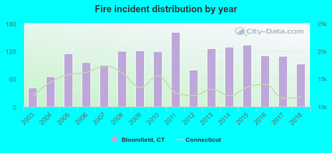 According to the data from the years 2003 - 2018 the average number of fires per year is 107. The highest number of fire incidents - 161 took place in 2011, and the least - 41 in 2003. The data has an increasing trend.
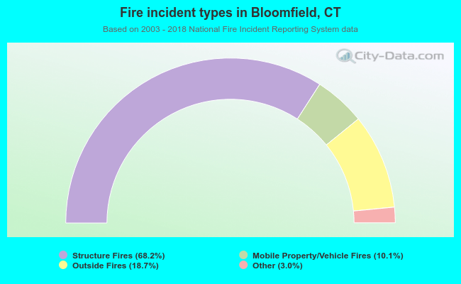 When looking into fire subcategories, the most reports belonged to: Structure Fires (68.2%), and Outside Fires (18.7%).
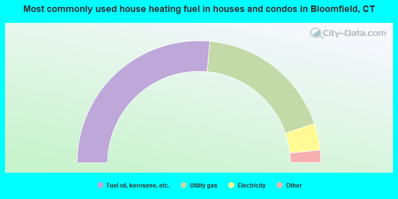
- 52.8%Fuel oil, kerosene, etc.
- 36.7%Utility gas
- 7.1%Electricity
- 2.4%Bottled, tank, or LP gas
- 0.4%Coal or coke
- 0.3%Other fuel
- 0.1%Wood
- 0.1%No fuel used
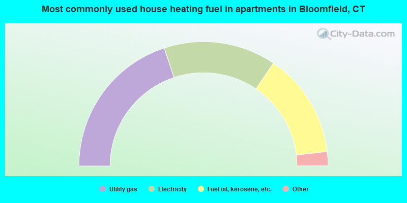
- 39.8%Utility gas
- 29.2%Electricity
- 27.3%Fuel oil, kerosene, etc.
- 1.9%Bottled, tank, or LP gas
- 1.9%No fuel used
Bloomfield compared to Connecticut state average:
- Unemployed percentage below state average.
- Black race population percentage significantly above state average.
- Hispanic race population percentage significantly below state average.
- Median age significantly above state average.
- Length of stay since moving in significantly above state average.
- Number of rooms per house significantly below state average.
- House age significantly below state average.
Bloomfield on our top lists:
- #12 on the list of "Top 101 cities with largest percentage of females in industries: finance and insurance (population 5,000+)"
- #27 on the list of "Top 101 cities with the smallest racial income disparities between White and Black householders (with at least 2,000 householders)"
- #36 on the list of "Top 101 cities with largest percentage of females in occupations: counselors, social workers, and other community and social service specialists (population 5,000+)"
- #36 on the list of "Top 101 cities with largest percentage of males in occupations: librarians, curators, and archivists (population 5,000+)"
- #47 on the list of "Top 101 cities with largest percentage of males in industries: publishing, and motion picture and sound recording industries (population 5,000+)"
- #57 on the list of "Top 101 cities with largest percentage of females in occupations: other financial specialists (population 5,000+)"
- #67 on the list of "Top 101 cities with largest percentage of females in occupations: nursing, psychiatric, and home health aides (population 5,000+)"
- #68 on the list of "Top 101 cities with largest percentage of males in occupations: mathematical science occupations (population 5,000+)"
- #70 on the list of "Top 101 cities with largest percentage of males in occupations: other office and administrative support workers including supervisors (population 5,000+)"
- #75 on the list of "Top 101 cities with largest percentage of females in industries: paper and paper products merchant wholesalers (population 5,000+)"
- #95 on the list of "Top 101 cities with largest percentage of males in industries: office supplies and stationery stores (population 5,000+)"
- #95 on the list of "Top 101 cities with the most residents born in United Kingdom (population 500+)"
- #95 on the list of "Top 101 cities with the most residents born in Yugoslavia (population 500+)"
- #95 on the list of "Top 101 cities with the most residents born in Asia, n.e.c. (population 500+)"
- #95 on the list of "Top 101 cities with the most residents born in Melanesia (population 500+)"
- #95 on the list of "Top 101 cities with the most residents born in Micronesia (population 500+)"
- #95 on the list of "Top 101 cities with the most residents born in Polynesia (population 500+)"
- #2 on the list of "Top 101 counties with highest percentage of residents voting for Obama (Democrat) in the 2012 Presidential Election"
- #17 on the list of "Top 101 counties with the most Catholic congregations"
- #19 on the list of "Top 101 counties with the lowest Particulate Matter (PM10) Annual air pollution readings in 2012 (µg/m3)"
- #24 on the list of "Top 101 counties with the highest percentage of residents that visited a dentist within the past year"
- #29 on the list of "Top 101 counties with the most Mainline Protestant congregations"

|
|
Total of 252 patent applications in 2008-2024.