Bono, Arkansas
Submit your own pictures of this city and show them to the world
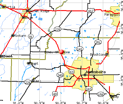
- OSM Map
- General Map
- Google Map
- MSN Map
Population change since 2000: +77.9%
| Males: 1,382 | |
| Females: 1,308 |
| Median resident age: | 29.6 years |
| Arkansas median age: | 38.9 years |
Zip codes: 72416.
| Bono: | $54,516 |
| AR: | $55,432 |
Estimated per capita income in 2022: $21,880 (it was $13,764 in 2000)
Bono city income, earnings, and wages data
Estimated median house or condo value in 2022: $152,683 (it was $52,100 in 2000)
| Bono: | $152,683 |
| AR: | $179,800 |
Mean prices in 2022: all housing units: $135,289; detached houses: $140,924; mobile homes: $33,956
Median gross rent in 2022: $821.
(14.2% for White Non-Hispanic residents, 24.8% for Black residents, 51.5% for Hispanic or Latino residents, 4.5% for two or more races residents)
Detailed information about poverty and poor residents in Bono, AR

Compare current foreclosures near Bono, AR:
| Photo | Address | Area | Beds / Baths | Price | Details |
|---|---|---|---|---|---|

|
#1
N Deborah St
Bono, AR 72416
|
1,325 sq. feet
|
1 baths 3 beds |
show details | |

|
#2
Michael St
Bono, AR 72416
|
1,404 sq. feet
|
1 baths - beds |
show details | |

|
#3
Michael St
Bono, AR 72416
|
1,126 sq. feet
|
2 baths - beds |
show details | |

|
#4
County Road 111
Bono, AR 72416
|
1,404 sq. feet
|
2 baths - beds |
show details | |

|
#5
Alta St
Bono, AR 72416
|
1,072 sq. feet
|
1 baths - beds |
show details | |

|
#6
County Road 318
Bono, AR 72416
|
2,882 sq. feet
|
2 baths - beds |
show details | |

|
#7
County Road 384
Bono, AR 72416
|
1,325 sq. feet
|
1 baths - beds |
show details | |

|
#8
County Road 323
Bono, AR 72416
|
1,048 sq. feet
|
1 baths - beds |
show details | |

|
#9
Redwood Dr
Bono, AR 72416
|
- sq. feet
|
- baths - beds |
show details | |

|
#10
County Road 118
Bono, AR 72416
|
1,280 sq. feet
|
- baths - beds |
show details |
| Photo | Address | Area | Beds / Baths | Price | Details |
|---|---|---|---|---|---|

|
#11
County Road 323
Bono, AR 72416
|
- sq. feet
|
- baths - beds |
show details | |

|
#12
County Road 377
Bono, AR 72416
|
- sq. feet
|
- baths - beds |
show details | |

|
#13
N Main St, Apt A
Bono, AR 72416
|
- sq. feet
|
- baths - beds |
show details | |

|
#14
Silverleaf Cir
Bono, AR 72416
|
- sq. feet
|
- baths - beds |
show details | |

|
#15
S Deborah St
Bono, AR 72416
|
- sq. feet
|
- baths - beds |
show details | |

|
#16
Airport Rd
Jonesboro, AR 72401
|
2,480 sq. feet
|
2 baths 4 beds |
$199,900
|
show details |

|
#17
Sartin Ln
Jonesboro, AR 72404
|
- sq. feet
|
4 baths 5 beds |
$186,000
|
show details |

|
#18
SW Broad St
Hoxie, AR 72433
|
1,341 sq. feet
|
2 baths 3 beds |
show details | |

|
#19
Prospector Dr
Jonesboro, AR 72405
|
- sq. feet
|
2 baths 3 beds |
show details | |

|
#20
NW 2nd St
Walnut Ridge, AR 72476
|
1,862 sq. feet
|
2 baths 3 beds |
show details |
| Photo | Address | Area | Beds / Baths | Price | Details |
|---|---|---|---|---|---|

|
#21
Wendy St.
Paragould, AR 72450
|
1,757 sq. feet
|
2 baths - beds |
show details | |

|
#22
Brownwood Cir
Jonesboro, AR 72404
|
3,363 sq. feet
|
2 baths - beds |
show details | |

|
#23
Village Dr
Jonesboro, AR 72404
|
1,511 sq. feet
|
2 baths - beds |
show details | |

|
#24
Flemon Rd
Jonesboro, AR 72404
|
1,269 sq. feet
|
1 baths - beds |
show details | |

|
#25
Greene 714 Rd
Paragould, AR 72450
|
1,344 sq. feet
|
1 baths - beds |
show details | |

|
#26
Virginia Dr
Jonesboro, AR 72401
|
1,767 sq. feet
|
1 baths - beds |
show details | |

|
#27
Co Rd 428
Jonesboro, AR 72404
|
- sq. feet
|
2 baths - beds |
show details | |

|
#28
Chalet Dr
Jonesboro, AR 72404
|
1,698 sq. feet
|
2 baths - beds |
show details | |

|
#29
Wildwood Ct
Jonesboro, AR 72401
|
1,548 sq. feet
|
2 baths - beds |
show details | |

|
#30
E Walnut St
Walnut Ridge, AR 72476
|
2,211 sq. feet
|
1 baths - beds |
show details |
| Photo | Address | Area | Beds / Baths | Price | Details |
|---|---|---|---|---|---|

|
#31
SW Broad St
Hoxie, AR 72433
|
1,320 sq. feet
|
1 baths - beds |
show details | |

|
#32
Lawrence Road 730
Alicia, AR 72410
|
1,320 sq. feet
|
1 baths - beds |
show details | |

|
#33
Greenmeadow Ln
Jonesboro, AR 72404
|
2,468 sq. feet
|
3 baths - beds |
show details | |

|
#34
Locust Dr
Jonesboro, AR 72401
|
1,102 sq. feet
|
1 baths - beds |
show details | |

|
#35
Valley Dr
Jonesboro, AR 72401
|
1,620 sq. feet
|
1 baths - beds |
show details | |

|
#36
Wood St
Jonesboro, AR 72401
|
1,557 sq. feet
|
2 baths - beds |
show details | |

|
#37
Carolyn Dr
Jonesboro, AR 72404
|
3,198 sq. feet
|
2 baths - beds |
show details | |

|
#38
Wesley Ct
Jonesboro, AR 72401
|
1,368 sq. feet
|
1 baths - beds |
show details | |

|
#39
Shadow Ln
Jonesboro, AR 72401
|
1,505 sq. feet
|
2 baths - beds |
show details | |

|
#40
Brandon Dr
Jonesboro, AR 72401
|
1,160 sq. feet
|
1 baths - beds |
show details |
| Photo | Address | Area | Beds / Baths | Price | Details |
|---|---|---|---|---|---|

|
#41
County Road 472
Jonesboro, AR 72404
|
1,488 sq. feet
|
2 baths - beds |
show details | |

|
#42
Flatrock Trl
Jonesboro, AR 72404
|
2,691 sq. feet
|
3 baths - beds |
show details | |

|
#43
Rhonda Dr
Jonesboro, AR 72404
|
1,440 sq. feet
|
2 baths - beds |
show details | |

|
#44
Ebbert Dr
Jonesboro, AR 72404
|
2,865 sq. feet
|
2 baths - beds |
show details | |

|
#45
Medallion Cir
Jonesboro, AR 72404
|
1,070 sq. feet
|
2 baths - beds |
show details | |

|
#46
Victoria Watts Pl
Jonesboro, AR 72404
|
1,598 sq. feet
|
2 baths - beds |
show details | |

|
#47
Middlefield Dr
Jonesboro, AR 72401
|
1,260 sq. feet
|
2 baths - beds |
show details | |

|
#48
Wakefield Dr
Jonesboro, AR 72404
|
1,300 sq. feet
|
2 baths - beds |
show details | |

|
#49
Highway 141 S
Paragould, AR 72450
|
1,144 sq. feet
|
1 baths - beds |
show details | |

|
Check over 1 million property listings on Foreclosure.com!
|
browse all offers | |||


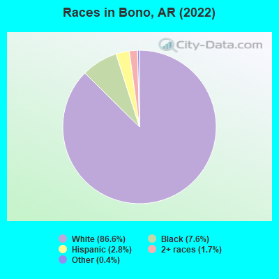
- 2,20186.6%White alone
- 1937.6%Black alone
- 702.8%Hispanic
- 431.7%Two or more races
- 90.4%Other race alone
According to our research of Arkansas and other state lists, there were 4 registered sex offenders living in Bono, Arkansas as of April 28, 2024.
The ratio of all residents to sex offenders in Bono is 617 to 1.
The ratio of registered sex offenders to all residents in this city is lower than the state average.
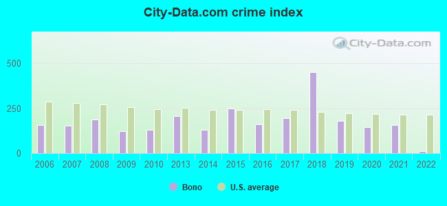
Type |
2009 |
2010 |
2013 |
2014 |
2015 |
2016 |
2017 |
2018 |
2019 |
2020 |
2021 |
2022 |
|---|---|---|---|---|---|---|---|---|---|---|---|---|
| Murders (per 100,000) | 0 (0.0) | 0 (0.0) | 0 (0.0) | 0 (0.0) | 0 (0.0) | 0 (0.0) | 0 (0.0) | 0 (0.0) | 0 (0.0) | 0 (0.0) | 0 (0.0) | 0 (0.0) |
| Rapes (per 100,000) | 0 (0.0) | 3 (140.8) | 2 (92.9) | 1 (46.4) | 4 (184.7) | 2 (88.6) | 1 (43.4) | 8 (332.6) | 3 (122.7) | 3 (119.2) | 4 (151.7) | 0 (0.0) |
| Robberies (per 100,000) | 1 (62.2) | 0 (0.0) | 0 (0.0) | 0 (0.0) | 0 (0.0) | 0 (0.0) | 0 (0.0) | 0 (0.0) | 0 (0.0) | 0 (0.0) | 0 (0.0) | 0 (0.0) |
| Assaults (per 100,000) | 2 (124.4) | 0 (0.0) | 2 (92.9) | 3 (139.1) | 1 (46.2) | 3 (132.9) | 10 (434.0) | 13 (540.5) | 3 (122.7) | 2 (79.5) | 1 (37.9) | 0 (0.0) |
| Burglaries (per 100,000) | 9 (559.7) | 3 (140.8) | 23 (1,068) | 10 (463.6) | 9 (415.5) | 9 (398.8) | 8 (347.2) | 11 (457.4) | 6 (245.5) | 1 (39.7) | 0 (0.0) | 0 (0.0) |
| Thefts (per 100,000) | 16 (995.0) | 5 (234.6) | 21 (975.4) | 18 (834.5) | 34 (1,570) | 19 (841.8) | 20 (868.1) | 28 (1,164) | 19 (777.4) | 15 (595.9) | 14 (530.9) | 8 (292.2) |
| Auto thefts (per 100,000) | 0 (0.0) | 0 (0.0) | 0 (0.0) | 0 (0.0) | 0 (0.0) | 0 (0.0) | 4 (173.6) | 0 (0.0) | 3 (122.7) | 3 (119.2) | 2 (75.8) | 0 (0.0) |
| Arson (per 100,000) | 0 (0.0) | 0 (0.0) | 0 (0.0) | 0 (0.0) | 0 (0.0) | 0 (0.0) | 0 (0.0) | 0 (0.0) | 0 (0.0) | 1 (39.7) | 0 (0.0) | 0 (0.0) |
| City-Data.com crime index | 122.5 | 131.9 | 206.7 | 130.7 | 248.8 | 159.1 | 194.4 | 452.8 | 180.9 | 147.4 | 156.2 | 11.7 |
The City-Data.com crime index weighs serious crimes and violent crimes more heavily. Higher means more crime, U.S. average is 246.1. It adjusts for the number of visitors and daily workers commuting into cities.
Crime rate in Bono detailed stats: murders, rapes, robberies, assaults, burglaries, thefts, arson
Full-time law enforcement employees in 2021, including police officers: 4 (4 officers - 4 male; 0 female).
| Officers per 1,000 residents here: | 1.52 |
| Arkansas average: | 2.25 |
 Recent articles from our blog. Our writers, many of them Ph.D. graduates or candidates, create easy-to-read articles on a wide variety of topics.

 | Tell me about Jonesboro (24 replies) |
| Info on Paragould/ Bono AR (4 replies) |
| need info on Jonesboro (60 replies) |
| Any Arkansas State Universtity Students? (17 replies) |
| Best place to live in Southern AR? (24 replies) |
| Need info about Trumann (11 replies) |
Latest news from Bono, AR collected exclusively by city-data.com from local newspapers, TV, and radio stations
Ancestries: American (28.4%), Irish (15.3%), English (12.4%), German (7.2%), European (2.1%), Scottish (1.3%).
Current Local Time: CST time zone
Incorporated on 07/12/1916
Elevation: 260 feet
Land area: 1.44 square miles.
Population density: 1,873 people per square mile (low).
10 residents are foreign born
| This city: | 0.4% |
| Arkansas: | 5.0% |
Median real estate property taxes paid for housing units with mortgages in 2022: $595 (0.4%)
Median real estate property taxes paid for housing units with no mortgage in 2022: $323 (0.3%)
Nearest city with pop. 50,000+: Jonesboro, AR  (8.1 miles , pop. 55,515).
Nearest city with pop. 200,000+: Memphis, TN (71.9 miles , pop. 650,100).
Nearest city with pop. 1,000,000+: Dallas, TX (404.0 miles , pop. 1,188,580).
Nearest cities:
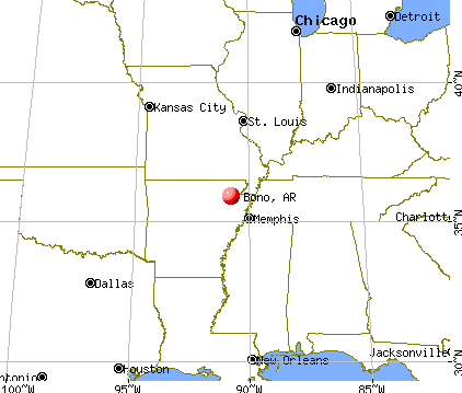
), ), )Latitude: 35.91 N, Longitude: 90.80 W
Area code commonly used in this area: 870

Single-family new house construction building permits:
- 2022: 28 buildings, average cost: $146,300
- 2021: 43 buildings, average cost: $239,200
- 2020: 31 buildings, average cost: $75,000
- 2019: 23 buildings, average cost: $148,800
- 2018: 15 buildings, average cost: $110,700
- 2017: 13 buildings, average cost: $109,800
- 2016: 12 buildings, average cost: $100,500
- 2015: 13 buildings, average cost: $108,900
- 2014: 8 buildings, average cost: $18,800
- 2013: 7 buildings, average cost: $14,300
- 2012: 7 buildings, average cost: $90,000
- 2011: 4 buildings, average cost: $161,300
| Here: | 2.8% |
| Arkansas: | 3.4% |
- Health care (9.4%)
- Construction (8.3%)
- Accommodation & food services (6.9%)
- Educational services (4.1%)
- Food (4.0%)
- Miscellaneous manufacturing (3.9%)
- Machinery (3.9%)
- Construction (15.1%)
- Machinery (6.2%)
- Public administration (4.7%)
- Accommodation & food services (4.7%)
- Miscellaneous manufacturing (4.4%)
- Food (4.2%)
- Repair & maintenance (3.9%)
- Health care (17.3%)
- Accommodation & food services (9.4%)
- Educational services (6.5%)
- Social assistance (6.2%)
- Administrative & support & waste management services (4.7%)
- Finance & insurance (4.4%)
- Department & other general merchandise stores (4.1%)
- Other production occupations, including supervisors (9.9%)
- Building and grounds cleaning and maintenance occupations (6.3%)
- Other sales and related occupations, including supervisors (5.0%)
- Driver/sales workers and truck drivers (4.1%)
- Material recording, scheduling, dispatching, and distributing workers (3.7%)
- Laborers and material movers, hand (3.6%)
- Metal workers and plastic workers (3.4%)
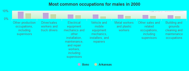
- Other production occupations, including supervisors (9.4%)
- Driver/sales workers and truck drivers (7.8%)
- Electrical equipment mechanics and other installation, maintenance, and repair workers, including supervisors (5.7%)
- Vehicle and mobile equipment mechanics, installers, and repairers (5.7%)
- Metal workers and plastic workers (5.5%)
- Other sales and related occupations, including supervisors (5.2%)
- Building and grounds cleaning and maintenance occupations (4.9%)
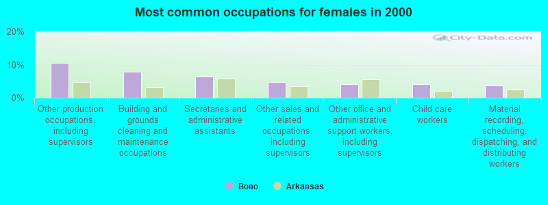
- Other production occupations, including supervisors (10.6%)
- Building and grounds cleaning and maintenance occupations (7.9%)
- Secretaries and administrative assistants (6.5%)
- Other sales and related occupations, including supervisors (4.7%)
- Other office and administrative support workers, including supervisors (4.1%)
- Child care workers (4.1%)
- Material recording, scheduling, dispatching, and distributing workers (3.8%)
Average climate in Bono, Arkansas
Based on data reported by over 4,000 weather stations


|
|


Tornado activity:
Bono-area historical tornado activity is near Arkansas state average. It is 122% greater than the overall U.S. average.
On 5/26/1973, a category F4 (max. wind speeds 207-260 mph) tornado 8.6 miles away from the Bono city center killed 3 people and injured 289 people and caused between $5000 and $50,000 in damages.
On 5/15/1968, a category F4 tornado 24.9 miles away from the city center killed 35 people and injured 364 people and caused between $5000 and $50,000 in damages.
Earthquake activity:
Bono-area historical earthquake activity is significantly above Arkansas state average. It is 451% greater than the overall U.S. average.On 3/25/1976 at 00:41:20, a magnitude 5.0 (4.9 MB, 5.0 LG, Class: Moderate, Intensity: VI - VII) earthquake occurred 32.5 miles away from the city center
On 5/4/1991 at 01:18:54, a magnitude 5.0 (4.4 MB, 4.6 LG, 5.0 LG, Depth: 3.1 mi) earthquake occurred 70.7 miles away from the city center
On 9/26/1990 at 13:18:51, a magnitude 5.0 (4.7 MB, 4.8 LG, 5.0 LG, Depth: 7.7 mi) earthquake occurred 111.7 miles away from the city center
On 4/27/1989 at 16:47:49, a magnitude 4.7 (4.6 MB, 4.7 LG, 4.3 LG, Class: Light, Intensity: IV - V) earthquake occurred 58.0 miles away from the city center
On 3/25/1976 at 01:00:11, a magnitude 4.5 (4.1 MB, 4.5 LG) earthquake occurred 27.4 miles away from Bono center
On 5/4/2001 at 06:42:12, a magnitude 4.7 (4.2 MB, 4.7 LG, 4.5 LG) earthquake occurred 92.5 miles away from the city center
Magnitude types: regional Lg-wave magnitude (LG), body-wave magnitude (MB)
Natural disasters:
The number of natural disasters in Craighead County (22) is greater than the US average (15).Major Disasters (Presidential) Declared: 17
Emergencies Declared: 2
Causes of natural disasters: Storms: 16, Floods: 13, Tornadoes: 9, Winds: 2, Winter Storms: 2, Hurricane: 1, Ice Storm: 1, Tropical Storm: 1, Other: 1 (Note: some incidents may be assigned to more than one category).

Hospitals and medical centers near Bono:
- RIDGECREST HEALTH AND REHABILITATION (Nursing Home, about 6 miles away; JONESBORO, AR)
- ROSE CARE CENTER OF JONESBORO (Nursing Home, about 6 miles away; JONESBORO, AR)
- ST BERNARDS MEDICAL CENTER Acute Care Hospitals (about 8 miles away; JONESBORO, AR)
- OUTPATIENT SURGERY CENTER OF JONESBORO (Hospital, about 8 miles away; JONESBORO, AR)
- ST BERNARDS REGIONAL MED CTR-DIALYSIS (Dialysis Facility, about 8 miles away; JONESBORO, AR)
- CRAIGHEAD COUNTY HEALTH UNIT (Home Health Center, about 8 miles away; JONESBORO, AR)
- GERIATRICS NURSING CENTER (Nursing Home, about 9 miles away; JONESBORO, AR)
Colleges/universities with over 2000 students nearest to Bono:
- Arkansas State University-Main Campus (about 9 miles; Jonesboro, AR; Full-time enrollment: 12,323)
- Three Rivers Community College (about 64 miles; Poplar Bluff, MO; FT enrollment: 3,360)
- Southwest Tennessee Community College (about 69 miles; Memphis, TN; FT enrollment: 8,043)
- Rhodes College (about 70 miles; Memphis, TN; FT enrollment: 2,052)
- Harding University (about 70 miles; Searcy, AR; FT enrollment: 5,360)
- University of Memphis (about 72 miles; Memphis, TN; FT enrollment: 17,427)
- Dyersburg State Community College (about 80 miles; Dyersburg, TN; FT enrollment: 2,211)
Points of interest:
Notable locations in Bono: Bono Fire Department Bono Station (A), Bono Police Department (B). Display/hide their locations on the map
Drinking water stations with addresses in Bono that have no violations reported:
- BONO WATERWORKS (Population served: 1,971, Primary Water Source Type: Groundwater)
| This city: | 2.6 people |
| Arkansas: | 2.5 people |
| This city: | 70.3% |
| Whole state: | 67.6% |
| This city: | 8.1% |
| Whole state: | 5.7% |
Likely homosexual households (counted as self-reported same-sex unmarried-partner households)
- Lesbian couples: 0.1% of all households
- Gay men: 0.4% of all households
Banks with branches in Bono (2011 data):
- The First National Bank of Lawrence County at Walnut Ridge: Bono Branch at 131 Highway 63b, branch established on 2008/03/31. Info updated 2006/11/03: Bank assets: $186.9 mil, Deposits: $166.4 mil, headquarters in Walnut Ridge, AR, positive income, Agricultural Specialization, 5 total offices, Holding Company: First National Capital Corporation
For population 15 years and over in Bono:
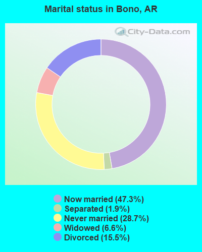
- Never married: 28.7%
- Now married: 47.3%
- Separated: 1.9%
- Widowed: 6.6%
- Divorced: 15.5%
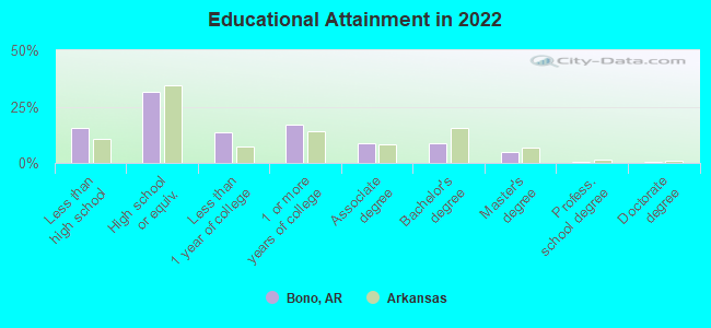
For population 25 years and over in Bono:
- High school or higher: 83.8%
- Bachelor's degree or higher: 15.3%
- Graduate or professional degree: 5.0%
- Unemployed: 5.2%
- Mean travel time to work (commute): 31.1 minutes
| Here: | 10.3 |
| Arkansas average: | 11.4 |
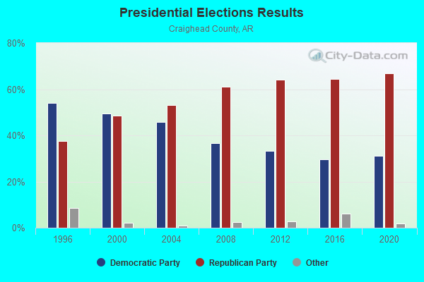
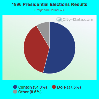
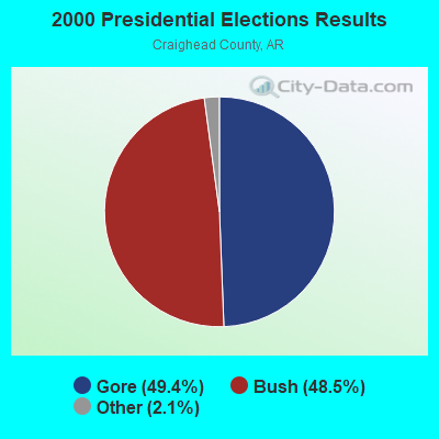
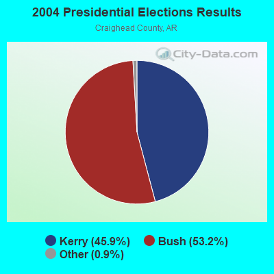
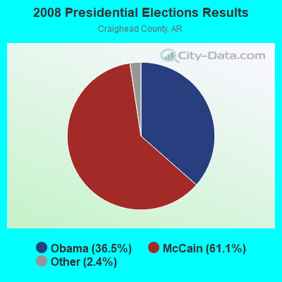
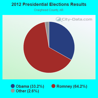
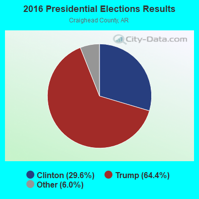
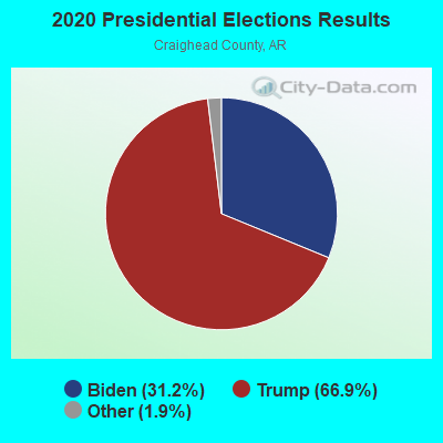
Graphs represent county-level data. Detailed 2008 Election Results
Religion statistics for Bono, AR (based on Craighead County data)
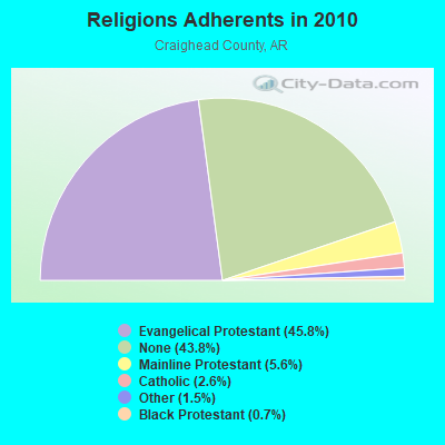
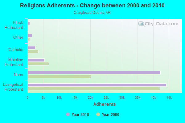
| Religion | Adherents | Congregations |
|---|---|---|
| Evangelical Protestant | 44,184 | 129 |
| Mainline Protestant | 5,408 | 24 |
| Catholic | 2,470 | 2 |
| Other | 1,477 | 10 |
| Black Protestant | 655 | 5 |
| None | 42,249 | - |
Food Environment Statistics:
| Craighead County: | 2.42 / 10,000 pop. |
| State: | 2.02 / 10,000 pop. |
| Craighead County: | 0.33 / 10,000 pop. |
| State: | 0.25 / 10,000 pop. |
| Here: | 0.22 / 10,000 pop. |
| Arkansas: | 0.59 / 10,000 pop. |
| Craighead County: | 4.52 / 10,000 pop. |
| Arkansas: | 4.94 / 10,000 pop. |
| This county: | 8.16 / 10,000 pop. |
| State: | 6.66 / 10,000 pop. |
| Here: | 8.6% |
| State: | 9.8% |
| This county: | 29.3% |
| State: | 29.1% |
| This county: | 13.4% |
| Arkansas: | 13.6% |
Health and Nutrition:
| This city: | 48.2% |
| State: | 48.2% |
| Bono: | 44.2% |
| Arkansas: | 44.2% |
| Bono: | 28.5 |
| State: | 28.9 |
| Bono: | 19.5% |
| State: | 21.6% |
| This city: | 9.9% |
| Arkansas: | 11.3% |
| Bono: | 6.8 |
| Arkansas: | 6.8 |
| Bono: | 33.9% |
| Arkansas: | 34.0% |
| This city: | 56.5% |
| Arkansas: | 54.4% |
| Here: | 79.4% |
| Arkansas: | 78.0% |
More about Health and Nutrition of Bono, AR Residents
| Local government employment and payroll (March 2022) | |||||
| Function | Full-time employees | Monthly full-time payroll | Average yearly full-time wage | Part-time employees | Monthly part-time payroll |
|---|---|---|---|---|---|
| Water Supply | 6 | $18,054 | $36,108 | 0 | $0 |
| Police Protection - Officers | 4 | $14,118 | $42,354 | 0 | $0 |
| Housing and Community Development (Local) | 1 | $2,789 | $33,468 | 0 | $0 |
| Streets and Highways | 1 | $2,672 | $32,064 | 0 | $0 |
| Totals for Government | 12 | $37,633 | $37,633 | 0 | $0 |
Bono government finances - Expenditure in 2017 (per resident):
- Current Operations - Financial Administration: $328,000 ($121.93)
Regular Highways: $313,000 ($116.36)
Police Protection: $245,000 ($91.08)
Local Fire Protection: $41,000 ($15.24)
Public Welfare - Other: $34,000 ($12.64)
Parks and Recreation: $30,000 ($11.15)
Health - Other: $3,000 ($1.12)
Solid Waste Management: $2,000 ($0.74)
- General - Interest on Debt: $6,000 ($2.23)
Bono government finances - Revenue in 2017 (per resident):
- Charges - Other: $5,000 ($1.86)
Solid Waste Management: $2,000 ($0.74)
- Miscellaneous - Fines and Forfeits: $81,000 ($30.11)
General Revenue - Other: $15,000 ($5.58)
Donations From Private Sources: $3,000 ($1.12)
Interest Earnings: $2,000 ($0.74)
- State Intergovernmental - Highways: $141,000 ($52.42)
General Local Government Support: $57,000 ($21.19)
- Tax - General Sales and Gross Receipts: $590,000 ($219.33)
Public Utilities Sales: $97,000 ($36.06)
Property: $59,000 ($21.93)
Other License: $22,000 ($8.18)
Bono government finances - Debt in 2017 (per resident):
- Long Term Debt - Beginning Outstanding - Unspecified Public Purpose: $202,000 ($75.09)
Outstanding Unspecified Public Purpose: $162,000 ($60.22)
Retired Unspecified Public Purpose: $39,000 ($14.50)
Bono government finances - Cash and Securities in 2017 (per resident):
- Other Funds - Cash and Securities: $911,000 ($338.66)
Businesses in Bono, AR
- H&R Block: 1
- SONIC Drive-In: 1
- Subway: 1
Strongest AM radio stations in Bono:
- KNEA (970 AM; 1 kW; JONESBORO, AR; Owner: CLEAR CHANNEL BROADCASTING LICENSES, INC.)
- WDIA (1070 AM; 50 kW; MEMPHIS, TN; Owner: CLEAR CHANNEL BROADCASTING LICENSES, INC.)
- WCRV (640 AM; 50 kW; COLLIERVILLE, TN; Owner: BOTT BROADCASTING COMPANY/TENNESSEE)
- KBTM (1230 AM; 1 kW; JONESBORO, AR; Owner: CAPSTAR TX LIMITED PARTNERSHIP)
- WGSF (1030 AM; 50 kW; MEMPHIS, TN; Owner: FLINN BROADCASTING CORPORATION)
- WMQM (1600 AM; 50 kW; LAKELAND, TN; Owner: WMQM, INC.)
- KOTC (830 AM; daytime; 10 kW; KENNETT, MO; Owner: EAGLE BLUFF ENTERPRISES)
- KRLW (1320 AM; 1 kW; WALNUT RIDGE, AR; Owner: COMBINED MEDIA GROUP, INC.)
- KGHT (880 AM; 50 kW; SHERIDAN, AR; Owner: METROPOLITAN RADIO GROUP, INC.)
- WJCE (680 AM; 10 kW; MEMPHIS, TN; Owner: ENTERCOM MEMPHIS LICENSE, LLC)
- KAAY (1090 AM; 50 kW; LITTLE ROCK, AR; Owner: CITADEL BROADCASTING COMPANY)
- KWAM (990 AM; 10 kW; MEMPHIS, TN; Owner: CONCORD MEDIA GROUP, INC.)
- WHBQ (560 AM; 5 kW; MEMPHIS, TN; Owner: FLINN BROADCASTING CORPORATION)
Strongest FM radio stations in Bono:
- KASU (91.9 FM; JONESBORO, AR; Owner: ARKANSAS STATE UNIVERSITY)
- KIYS (101.9 FM; JONESBORO, AR; Owner: ,CAPSTAR TX LIMITED PARTNERSHIP)
- KFIN (107.9 FM; JONESBORO, AR; Owner: CAPSTAR TX LIMITED PARTNERSHIP)
- KDEZ (100.5 FM; JONESBORO, AR; Owner: SAGA COMMUNICATIONS OF ARKANSAS, LLC)
- KBZR (95.9 FM; HARRISBURG, AR; Owner: CLEAR CHANNEL BROADCASTING LICENSES, INC.)
- KAOG (90.5 FM; JONESBORO, AR; Owner: AMERICAN FAMILY ASSOCIATION)
- KDXY (104.9 FM; LAKE CITY, AR; Owner: SAGA COMMUNICATIONS OF ARKANSAS, LLC)
- KDRS-FM (107.1 FM; PARAGOULD, AR; Owner: MOR MEDIA, INC.)
- WJZN (98.9 FM; MUNFORD, TN; Owner: MEMPHIS III LIMITED PARTNERSHIP)
- KJLV (105.3 FM; HOXIE, AR; Owner: EDUCATIONAL MEDIA FOUNDATION)
- KJBX (106.7 FM; TRUMANN, AR; Owner: SAGA COMMUNICATIONS OF ARKANSAS, LLC)
- WYPL (89.3 FM; MEMPHIS, TN; Owner: MEMPHIS/SHELBY COUNTY PUBLIC LIBRARY & INFO CNTR.)
- KRLW-FM (106.3 FM; WALNUT RIDGE, AR; Owner: COMBINED MEDIA GROUP, INC.)
- K202CG (88.3 FM; JONESBORO, AR; Owner: FAMILY STATIONS, INC.)
- K218DE (91.5 FM; JONESBORO, AR; Owner: CALVARY CHAPEL OF TWIN FALLS, INC.)
TV broadcast stations around Bono:
- KTEJ (Channel 19; JONESBORO, AR; Owner: ARKANSAS EDUCATIONAL TELEVISION COMMISSION)
- KAIT (Channel 8; JONESBORO, AR; Owner: LIBCO, INC.)
- K46EM (Channel 46; BATESVILLE, AR; Owner: MS COMMUNICATIONS, LLC)
- K54ER (Channel 54; JONESBORO, AR; Owner: TRINITY BROADCASTING NETWORK)
- KVTJ (Channel 48; JONESBORO, AR; Owner: AGAPE CHURCH, INC.)
- K27FC (Channel 27; PARAGOULD, AR; Owner: TRINITY BROADCASTING NETWORK)
Bono fatal accident list:
Mar 29, 2015 01:40 AM, Us-63-06, Lat: 35.923250, Lon: -90.813633, Vehicles: 1, Persons: 1, Fatalities: 1
Dec 29, 2011 02:59 PM, Co Rd 318, Lat: 35.896842, Lon: -90.749336, Vehicles: 1, Persons: 2, Fatalities: 1
May 25, 1997 11:55 AM, Us-63-06, Vehicles: 2, Persons: 3, Fatalities: 1
Mar 22, 1977 08:00 AM, Vehicles: 2, Persons: 3, Fatalities: 1
- National Bridge Inventory (NBI) Statistics
- 22Number of bridges
- 154ft / 47.3mTotal length
- $577,000Total costs
- 68,508Total average daily traffic
- 9,320Total average daily truck traffic
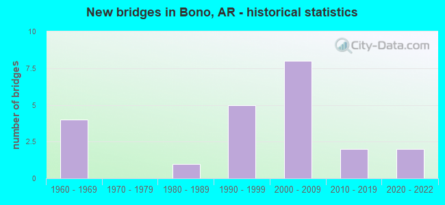
- New bridges - historical statistics
- 41960-1969
- 11980-1989
- 51990-1999
- 82000-2009
- 22010-2019
- 22020-2022
FCC Registered Cell Phone Towers:
1 (See the full list of FCC Registered Cell Phone Towers in Bono)FCC Registered Antenna Towers:
29 (See the full list of FCC Registered Antenna Towers)FCC Registered Commercial Land Mobile Towers:
1 (See the full list of FCC Registered Commercial Land Mobile Towers in Bono, AR)FCC Registered Broadcast Land Mobile Towers:
7 (See the full list of FCC Registered Broadcast Land Mobile Towers)FCC Registered Microwave Towers:
4- Bono, Lat: 35.908667 Lon: -90.790667, Call Sign: WQNS762,
Assigned Frequencies: 956.406 MHz, Grant Date: 05/28/2021, Expiration Date: 05/12/2031, Certifier: Rick Thomas, Registrant: Radio Communications Center, LLC, 3508 E. Highland Dr., Jonesboro, AR 72401, Phone: (870) 972-1000, Email:
- SEDGEWICK SS, Hwy 63 (Lat: 35.970000 Lon: -90.848694), Type: Ltower, Structure height: 38.1 m, Call Sign: WRCK877,
Assigned Frequencies: 6256.54 MHz, 6256.54 MHz, 6256.54 MHz, 6256.54 MHz, 6256.54 MHz, 6256.54 MHz, 6256.54 MHz, 6256.54 MHz, Grant Date: 10/27/2018, Expiration Date: 10/27/2028, Certifier: Steve Paquette, Registrant: Entergy Services, LLC, 425 West Capitol Ave., Little Rock, AR 72203-0551, Phone: (501) 377-5609, Email:
- KTEJ Tx Site, Ktej Tv 19 (Lat: 35.903889 Lon: -90.770556), Type: Gtower, Structure height: 275 m, Overall height: 295.3 m, Call Sign: WRME504,
Assigned Frequencies: 6937.50 MHz, Grant Date: 03/29/2021, Expiration Date: 06/01/2029, Certifier: Andrew Bicknell, Registrant: Munn-Reese, Coldwater, MI 49036, Phone: (517) 278-7339, Email:
- BONO, 3.2 Mi Sw Of (Lat: 35.863750 Lon: -90.815111), Type: Mast, Structure height: 43 m, Overall height: 47.2 m, Call Sign: WCU294,
Assigned Frequencies: 2112.00 MHz, 10875.0 MHz, 6315.84 MHz, 10955.0 MHz, 6375.14 MHz, 11035.0 MHz, Grant Date: 09/26/2000, Expiration Date: 08/01/2010, Cancellation Date: 01/14/2003, Certifier: Preston C Johnson, Registrant: Wiley Rein & Fielding LLP, 1776 K Street, N.W., Washington, DC 20006, Phone: (202) 719-3240, Fax: (202) 719-7049, Email:
FCC Registered Paging Towers:
2- On County Road, Approximately 2.5 Miles E. Of Bono (Lat: 35.907000 Lon: -90.751222), Call Sign: KNKJ587, Licensee ID: L00129112,
Assigned Frequencies: 152.150 MHz, 152.120 MHz, Grant Date: 05/24/1999, Expiration Date: 04/01/2009, Cancellation Date: 05/23/2009, Registrant: Radio Communications Center, 3508 E. Highland Dr., Jonesboro, AR 72401, Phone: (870) 972-1000
- On County Road #31, Approximately 2.5 Miles E. Of (Lat: 35.907000 Lon: -90.751222), Call Sign: KPE414, Licensee ID: L00129112,
Assigned Frequencies: 454.225 MHz, 454.025 MHz, Grant Date: 05/24/1999, Expiration Date: 04/01/2009, Cancellation Date: 05/23/2009, Registrant: Radio Communications Center, 3508 E. Highland Drive, Jonesboro, AR 72401, Phone: (870) 972-1000
FCC Registered Amateur Radio Licenses:
36 (See the full list of FCC Registered Amateur Radio Licenses in Bono)FAA Registered Aircraft Manufacturers and Dealers:
3 (See the full list of FAA Registered Manufacturers and Dealers in Bono)FAA Registered Aircraft:
11 (See the full list of FAA Registered Aircraft)| Home Mortgage Disclosure Act Aggregated Statistics For Year 2006 (Based on 1 partial tract) | ||
| C) Refinancings | ||
|---|---|---|
| Number | Average Value | |
| LOANS ORIGINATED | 1 | $42,930 |
| APPLICATIONS APPROVED, NOT ACCEPTED | 0 | $0 |
| APPLICATIONS DENIED | 0 | $0 |
| APPLICATIONS WITHDRAWN | 0 | $0 |
| FILES CLOSED FOR INCOMPLETENESS | 0 | $0 |
Detailed HMDA statistics for the following Tracts: 0012.00
2004 - 2018 National Fire Incident Reporting System (NFIRS) incidents
- Fire incident types reported to NFIRS in Bono, AR
- 45857.1%Outside Fires
- 24029.9%Structure Fires
- 8410.5%Mobile Property/Vehicle Fires
- 202.5%Other
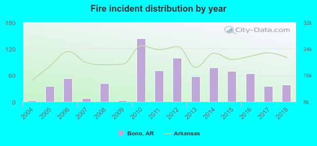 According to the data from the years 2004 - 2018 the average number of fire incidents per year is 53. The highest number of reported fire incidents - 144 took place in 2010, and the least - 3 in 2004. The data has an increasing trend.
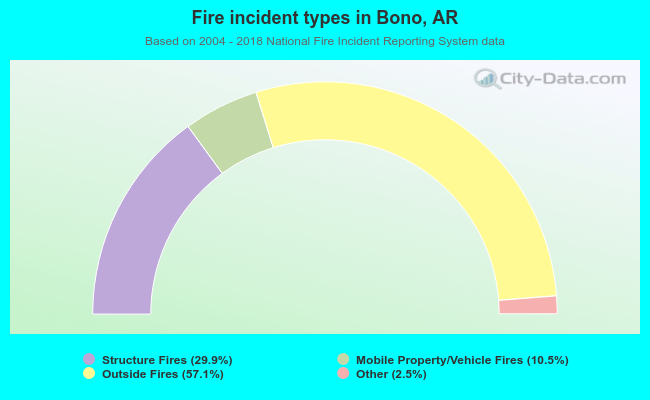 When looking into fire subcategories, the most reports belonged to: Outside Fires (57.1%), and Structure Fires (29.9%).
| Most common first names in Bono, AR among deceased individuals | ||
| Name | Count | Lived (average) |
|---|---|---|
| William | 31 | 70.3 years |
| James | 23 | 70.9 years |
| John | 17 | 70.2 years |
| Mary | 12 | 79.4 years |
| Robert | 11 | 69.1 years |
| Thomas | 10 | 72.5 years |
| Charles | 10 | 70.1 years |
| Roy | 9 | 78.7 years |
| George | 9 | 79.5 years |
| Willie | 8 | 76.0 years |
| Most common last names in Bono, AR among deceased individuals | ||
| Last name | Count | Lived (average) |
|---|---|---|
| Smith | 22 | 75.3 years |
| Davis | 21 | 71.0 years |
| Cook | 19 | 73.1 years |
| Tate | 17 | 77.5 years |
| Adams | 12 | 70.4 years |
| Williams | 11 | 68.2 years |
| Brown | 10 | 68.3 years |
| Minton | 10 | 75.8 years |
| Simpson | 8 | 74.6 years |
| Puckett | 8 | 79.2 years |
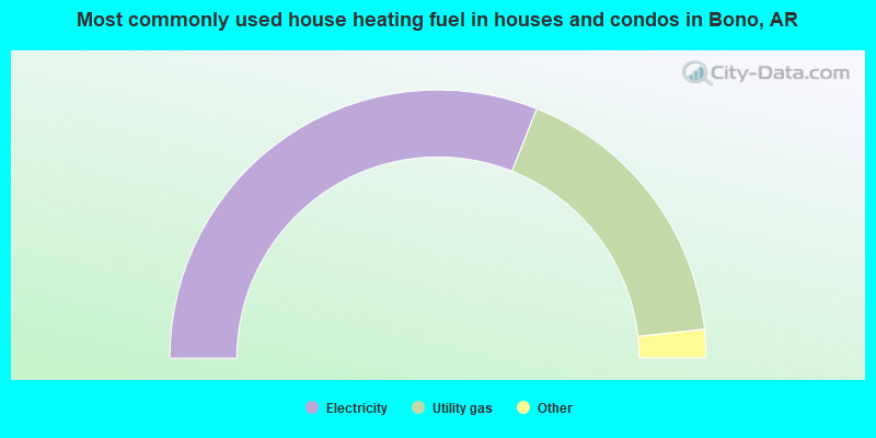
- 62.1%Electricity
- 34.6%Utility gas
- 1.6%Bottled, tank, or LP gas
- 1.6%No fuel used
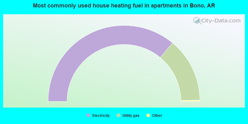
- 72.4%Electricity
- 27.6%Utility gas
Bono compared to Arkansas state average:
- Unemployed percentage below state average.
- Hispanic race population percentage below state average.
- Median age significantly below state average.
- Foreign-born population percentage significantly below state average.
- Length of stay since moving in significantly above state average.
- House age below state average.

|
Total of 6 patent applications in 2008-2024.