Brookland, Arkansas
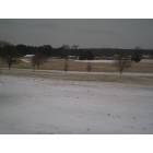
Brookland: Brookland on a snowy day
Brookland: taken along side Hwy 49 B North, Brookland, AR. View outside our kitchen window
- add
your
Submit your own pictures of this town and show them to the world
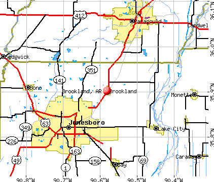
- OSM Map
- General Map
- Google Map
- MSN Map
Population change since 2000: +228.0%
| Males: 2,183 | |
| Females: 2,186 |
| Median resident age: | 27.1 years |
| Arkansas median age: | 38.9 years |
Zip codes: 72417.
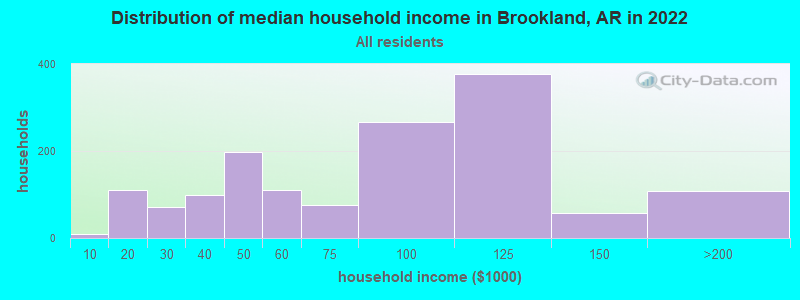
| Brookland: | $73,668 |
| AR: | $55,432 |
Estimated per capita income in 2022: $31,042 (it was $13,744 in 2000)
Brookland town income, earnings, and wages data
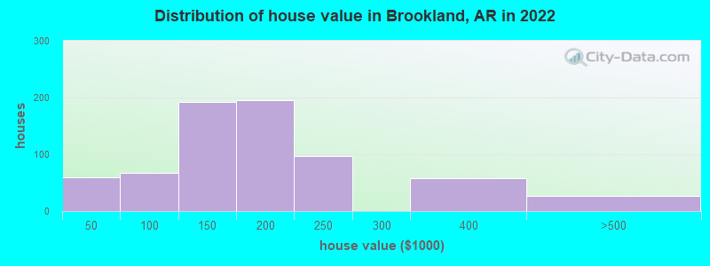
Estimated median house or condo value in 2022: $173,980 (it was $56,300 in 2000)
| Brookland: | $173,980 |
| AR: | $179,800 |
Mean prices in 2022: all housing units: $141,933; detached houses: $153,707; mobile homes: $46,574
Median gross rent in 2022: $891.
(9.0% for White Non-Hispanic residents, 20.8% for Black residents, 2.9% for two or more races residents)
Detailed information about poverty and poor residents in Brookland, AR


Compare current foreclosures near Brookland, AR:
| Photo | Address | Area | Beds / Baths | Price | Details |
|---|---|---|---|---|---|

|
#1
County Road 928
Brookland, AR 72417
|
1,144 sq. feet
|
1 baths - beds |
show details | |

|
#2
N Bernis St
Brookland, AR 72417
|
1,797 sq. feet
|
1 baths - beds |
show details | |

|
#3
County Road 979
Brookland, AR 72417
|
1,160 sq. feet
|
1 baths - beds |
show details | |

|
#4
N Oak St
Brookland, AR 72417
|
1,198 sq. feet
|
2 baths - beds |
show details | |

|
#5
Harper Dr
Brookland, AR 72417
|
- sq. feet
|
- baths - beds |
show details | |

|
#6
N Lynch St
Brookland, AR 72417
|
- sq. feet
|
- baths - beds |
show details | |

|
#7
W School St
Brookland, AR 72417
|
980 sq. feet
|
- baths - beds |
show details | |

|
#8
Story St
Brookland, AR 72417
|
- sq. feet
|
- baths - beds |
show details | |

|
#9
Harper Dr
Brookland, AR 72417
|
- sq. feet
|
- baths - beds |
show details | |

|
#10
County Road 765
Brookland, AR 72417
|
- sq. feet
|
- baths - beds |
show details |
| Photo | Address | Area | Beds / Baths | Price | Details |
|---|---|---|---|---|---|

|
#11
Wagner Place Dr, # 13
Brookland, AR 72417
|
- sq. feet
|
- baths - beds |
show details | |

|
#12
Manley Ln
Brookland, AR 72417
|
- sq. feet
|
- baths - beds |
show details | |

|
#13
County Road 7612
Brookland, AR 72417
|
- sq. feet
|
- baths - beds |
show details | |

|
#14
Wagner Place Dr, Unit 16
Brookland, AR 72417
|
- sq. feet
|
- baths - beds |
show details | |

|
#15
Clark Dr
Brookland, AR 72417
|
- sq. feet
|
- baths - beds |
show details | |

|
#16
Highway 49b N
Brookland, AR 72417
|
- sq. feet
|
- baths - beds |
show details | |

|
#17
Cody Ln
Brookland, AR 72417
|
- sq. feet
|
- baths - beds |
show details | |

|
#18
Brookvale Cir
Brookland, AR 72417
|
- sq. feet
|
- baths - beds |
show details | |

|
#19
E School St # 2
Brookland, AR 72417
|
- sq. feet
|
- baths - beds |
show details | |

|
#20
Harper Dr
Brookland, AR 72417
|
- sq. feet
|
- baths - beds |
show details |
| Photo | Address | Area | Beds / Baths | Price | Details |
|---|---|---|---|---|---|

|
#21
Airport Rd
Jonesboro, AR 72401
|
2,480 sq. feet
|
2 baths 4 beds |
$199,900
|
show details |

|
#22
Everett Bolton Ln
Brookland, AR 72417
|
- sq. feet
|
- baths - beds |
show details | |

|
#23
Sartin Ln
Jonesboro, AR 72404
|
- sq. feet
|
4 baths 5 beds |
$186,000
|
show details |

|
#24
Thorne Dr
Paragould, AR 72450
|
1,368 sq. feet
|
1 baths 5 beds |
show details | |

|
#25
Gann Ave
Monette, AR 72447
|
2,175 sq. feet
|
2 baths 3 beds |
show details | |

|
#26
N 12th Ave
Paragould, AR 72450
|
1,043 sq. feet
|
1 baths 3 beds |
show details | |

|
#27
N Deborah St
Bono, AR 72416
|
1,325 sq. feet
|
1 baths 3 beds |
show details | |

|
#28
Ridgefield Dr
Paragould, AR 72450
|
- sq. feet
|
2 baths 3 beds |
show details | |

|
#29
James Devaughn Dr
Paragould, AR 72450
|
- sq. feet
|
2 baths 3 beds |
show details | |

|
#30
Cloverdale St
Paragould, AR 72450
|
1,478 sq. feet
|
2 baths 3 beds |
show details |
| Photo | Address | Area | Beds / Baths | Price | Details |
|---|---|---|---|---|---|

|
#31
E Lake St
Paragould, AR 72450
|
1,040 sq. feet
|
1 baths - beds |
show details | |

|
#32
S 14th Ave
Paragould, AR 72450
|
1,041 sq. feet
|
1 baths - beds |
show details | |

|
#33
Brookside Cir
Paragould, AR 72450
|
1,258 sq. feet
|
2 baths 2 beds |
show details | |

|
#34
Emilee Jo Dr
Paragould, AR 72450
|
1,227 sq. feet
|
2 baths - beds |
show details | |

|
#35
S 7th St
Paragould, AR 72450
|
1,148 sq. feet
|
1 baths - beds |
show details | |

|
#36
Wendy St.
Paragould, AR 72450
|
1,757 sq. feet
|
2 baths - beds |
show details | |

|
#37
Prospector Dr
Jonesboro, AR 72405
|
- sq. feet
|
2 baths 3 beds |
show details | |

|
#38
Norma Jean Dr
Trumann, AR 72472
|
1,334 sq. feet
|
1 baths - beds |
show details | |

|
#39
Victoria Watts Pl
Jonesboro, AR 72404
|
1,598 sq. feet
|
2 baths - beds |
show details | |

|
#40
Oakland Dr
Paragould, AR 72450
|
2,376 sq. feet
|
2 baths - beds |
show details |
| Photo | Address | Area | Beds / Baths | Price | Details |
|---|---|---|---|---|---|

|
#41
Ladd St
Lake City, AR 72437
|
1,700 sq. feet
|
1 baths - beds |
show details | |

|
#42
Kirkwood Dr
Paragould, AR 72450
|
2,366 sq. feet
|
2 baths - beds |
show details | |

|
#43
County Road 318
Bono, AR 72416
|
2,882 sq. feet
|
2 baths - beds |
show details | |

|
#44
Alexander Cir
Paragould, AR 72450
|
2,346 sq. feet
|
2 baths - beds |
show details | |

|
#45
Christopher Dr
Paragould, AR 72450
|
2,074 sq. feet
|
2 baths - beds |
show details | |

|
#46
Carolyn Dr
Jonesboro, AR 72404
|
3,198 sq. feet
|
2 baths - beds |
show details | |

|
#47
Greene 718 Rd
Paragould, AR 72450
|
1,820 sq. feet
|
3 baths - beds |
show details | |

|
#48
Alicia Dr
Jonesboro, AR 72404
|
1,940 sq. feet
|
2 baths - beds |
show details | |

|
#49
Highway 141 S
Paragould, AR 72450
|
1,144 sq. feet
|
1 baths - beds |
show details | |

|
Check over 1 million property listings on Foreclosure.com!
|
browse all offers | |||


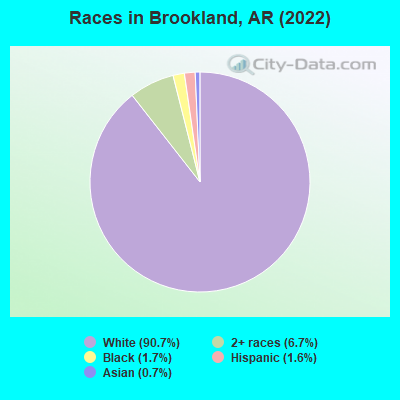
- 3,74690.7%White alone
- 2786.7%Two or more races
- 711.7%Black alone
- 641.6%Hispanic
- 270.7%Asian alone
- 20.05%American Indian alone
According to our research of Arkansas and other state lists, there were 2 registered sex offenders living in Brookland, Arkansas as of April 27, 2024.
The ratio of all residents to sex offenders in Brookland is 1,368 to 1.
The ratio of registered sex offenders to all residents in this city is much lower than the state average.
Type |
2012 |
2013 |
2014 |
2015 |
2016 |
2017 |
2018 |
2019 |
2020 |
2021 |
2022 |
|---|---|---|---|---|---|---|---|---|---|---|---|
| Murders (per 100,000) | 0 (0.0) | 0 (0.0) | 0 (0.0) | 0 (0.0) | 0 (0.0) | 0 (0.0) | 0 (0.0) | 0 (0.0) | 0 (0.0) | 0 (0.0) | 0 (0.0) |
| Rapes (per 100,000) | 0 (0.0) | 0 (0.0) | 3 (110.3) | 1 (28.6) | 0 (0.0) | 3 (89.5) | 2 (55.8) | 5 (133.0) | 1 (25.4) | 3 (72.5) | 9 (206.7) |
| Robberies (per 100,000) | 1 (59.5) | 0 (0.0) | 1 (36.8) | 0 (0.0) | 1 (30.8) | 0 (0.0) | 1 (27.9) | 0 (0.0) | 0 (0.0) | 1 (24.2) | 0 (0.0) |
| Assaults (per 100,000) | 0 (0.0) | 2 (107.4) | 3 (110.3) | 11 (314.4) | 2 (61.6) | 4 (119.3) | 5 (139.6) | 2 (53.2) | 0 (0.0) | 6 (145.1) | 11 (252.6) |
| Burglaries (per 100,000) | 5 (297.3) | 14 (751.5) | 12 (441.2) | 7 (200.1) | 6 (184.9) | 15 (447.4) | 9 (251.3) | 9 (239.4) | 1 (25.4) | 7 (169.2) | 17 (390.4) |
| Thefts (per 100,000) | 5 (297.3) | 14 (751.5) | 21 (772.1) | 34 (971.7) | 62 (1,911) | 91 (2,714) | 34 (949.2) | 50 (1,330) | 2 (50.7) | 28 (677.0) | 38 (872.6) |
| Auto thefts (per 100,000) | 0 (0.0) | 5 (268.4) | 0 (0.0) | 0 (0.0) | 3 (92.4) | 3 (89.5) | 2 (55.8) | 1 (26.6) | 1 (25.4) | 5 (120.9) | 7 (160.7) |
| Arson (per 100,000) | 0 (0.0) | 1 (53.7) | 0 (0.0) | 0 (0.0) | 0 (0.0) | 0 (0.0) | 0 (0.0) | 1 (26.6) | 0 (0.0) | 0 (0.0) | 0 (0.0) |
| City-Data.com crime index | 50.5 | 125.6 | 183.1 | 138.6 | 118.3 | 242.5 | 141.0 | 189.1 | 26.1 | 142.9 | 290.9 |
The City-Data.com crime index weighs serious crimes and violent crimes more heavily. Higher means more crime, U.S. average is 246.1. It adjusts for the number of visitors and daily workers commuting into cities.
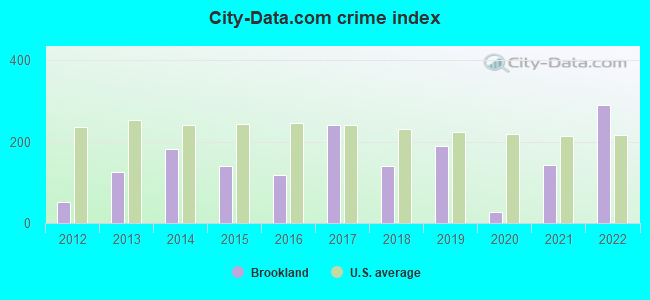
Crime rate in Brookland detailed stats: murders, rapes, robberies, assaults, burglaries, thefts, arson
Full-time law enforcement employees in 2021, including police officers: 6 (6 officers - 6 male; 0 female).
| Officers per 1,000 residents here: | 1.45 |
| Arkansas average: | 2.25 |
 Recent articles from our blog. Our writers, many of them Ph.D. graduates or candidates, create easy-to-read articles on a wide variety of topics.

 | Jonesboro Tornado (5 replies) |
| Deciding whether or not to more to Harrisburg (9 replies) |
| Finally decided to move to Jonesboro (5 replies) |
| Brookland land value (1 reply) |
| Moving to Lake City, Ar (3 replies) |
| Best place to live in Arkansas? (476 replies) |
Latest news from Brookland, AR collected exclusively by city-data.com from local newspapers, TV, and radio stations
Ancestries: English (16.6%), Scottish (10.9%), German (7.7%), Irish (7.5%), American (4.5%), Portuguese (2.2%).
Current Local Time: CST time zone
Elevation: 262 feet
Land area: 1.09 square miles.
Population density: 4,002 people per square mile (average).
35 residents are foreign born
| This town: | 0.8% |
| Arkansas: | 5.0% |
Median real estate property taxes paid for housing units with mortgages in 2022: $625 (0.3%)
Median real estate property taxes paid for housing units with no mortgage in 2022: $787 (0.7%)
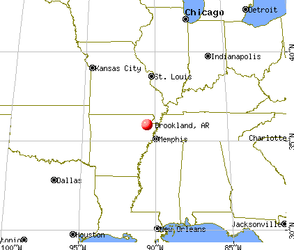
Nearest city with pop. 50,000+: Jonesboro, AR  (8.1 miles , pop. 55,515).
Nearest city with pop. 200,000+: Memphis, TN (64.3 miles , pop. 650,100).
Nearest city with pop. 1,000,000+: Dallas, TX (414.2 miles , pop. 1,188,580).
Nearest cities:
), ), ), ), )Latitude: 35.90 N, Longitude: 90.58 W
Area code commonly used in this area: 870

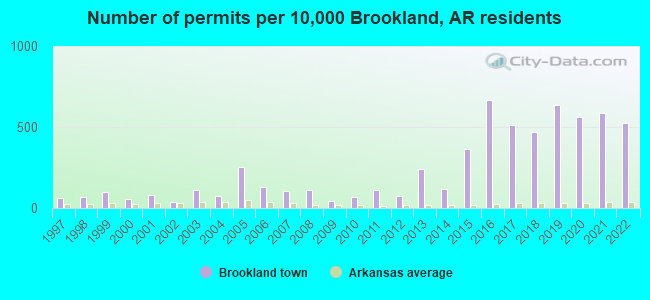
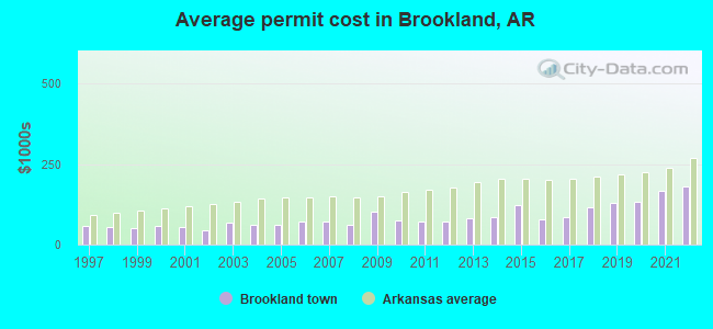
Single-family new house construction building permits:
- 2022: 70 buildings, average cost: $179,700
- 2021: 78 buildings, average cost: $165,500
- 2020: 75 buildings, average cost: $133,800
- 2019: 85 buildings, average cost: $131,100
- 2018: 63 buildings, average cost: $115,100
- 2017: 68 buildings, average cost: $85,500
- 2016: 89 buildings, average cost: $78,200
- 2015: 49 buildings, average cost: $123,800
- 2014: 16 buildings, average cost: $86,300
- 2013: 32 buildings, average cost: $82,600
- 2012: 10 buildings, average cost: $69,700
- 2011: 15 buildings, average cost: $72,500
- 2010: 9 buildings, average cost: $76,300
- 2009: 6 buildings, average cost: $100,500
- 2008: 15 buildings, average cost: $59,500
- 2007: 14 buildings, average cost: $72,400
- 2006: 17 buildings, average cost: $70,900
- 2005: 34 buildings, average cost: $60,200
- 2004: 10 buildings, average cost: $59,700
- 2003: 15 buildings, average cost: $68,000
- 2002: 5 buildings, average cost: $45,000
- 2001: 11 buildings, average cost: $52,900
- 2000: 7 buildings, average cost: $58,700
- 1999: 13 buildings, average cost: $50,400
- 1998: 9 buildings, average cost: $55,300
- 1997: 8 buildings, average cost: $57,100
| Here: | 2.8% |
| Arkansas: | 3.4% |
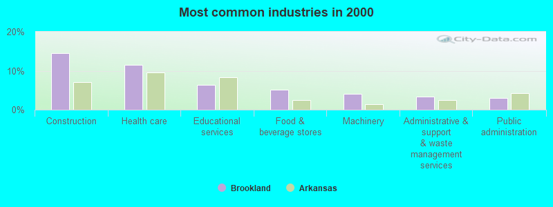
- Construction (14.6%)
- Health care (11.5%)
- Educational services (6.3%)
- Food & beverage stores (5.1%)
- Machinery (4.1%)
- Administrative & support & waste management services (3.4%)
- Public administration (3.1%)
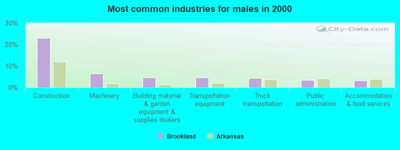
- Construction (23.0%)
- Machinery (6.6%)
- Building material & garden equipment & supplies dealers (4.6%)
- Transportation equipment (4.6%)
- Truck transportation (4.3%)
- Public administration (3.4%)
- Accommodation & food services (3.2%)
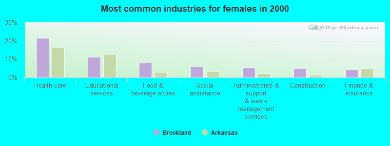
- Health care (21.4%)
- Educational services (11.2%)
- Food & beverage stores (7.9%)
- Social assistance (5.9%)
- Administrative & support & waste management services (5.6%)
- Construction (4.9%)
- Finance & insurance (4.3%)
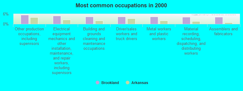
- Other production occupations, including supervisors (5.5%)
- Electrical equipment mechanics and other installation, maintenance, and repair workers, including supervisors (4.9%)
- Building and grounds cleaning and maintenance occupations (4.3%)
- Driver/sales workers and truck drivers (4.3%)
- Metal workers and plastic workers (4.3%)
- Material recording, scheduling, dispatching, and distributing workers (4.1%)
- Assemblers and fabricators (4.1%)
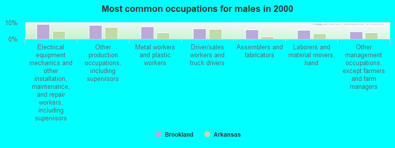
- Electrical equipment mechanics and other installation, maintenance, and repair workers, including supervisors (9.2%)
- Other production occupations, including supervisors (8.6%)
- Metal workers and plastic workers (7.5%)
- Driver/sales workers and truck drivers (6.3%)
- Assemblers and fabricators (5.7%)
- Laborers and material movers, hand (5.5%)
- Other management occupations, except farmers and farm managers (4.6%)
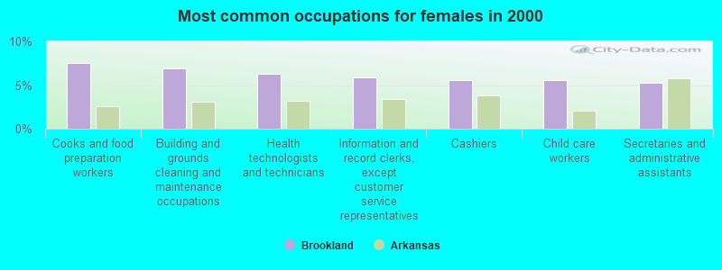
- Cooks and food preparation workers (7.6%)
- Building and grounds cleaning and maintenance occupations (6.9%)
- Health technologists and technicians (6.2%)
- Information and record clerks, except customer service representatives (5.9%)
- Cashiers (5.6%)
- Child care workers (5.6%)
- Secretaries and administrative assistants (5.3%)
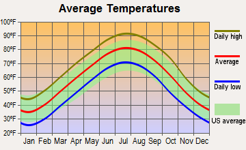
Average climate in Brookland, Arkansas
Based on data reported by over 4,000 weather stations


|
|


Tornado activity:
Brookland-area historical tornado activity is near Arkansas state average. It is 119% greater than the overall U.S. average.
On 5/26/1973, a category F4 (max. wind speeds 207-260 mph) tornado 7.4 miles away from the Brookland town center killed 3 people and injured 289 people and caused between $5000 and $50,000 in damages.
On 4/16/1998, a category F4 tornado 22.6 miles away from the town center killed 2 people and injured 12 people and caused $350,000 in damages.
Earthquake activity:
Brookland-area historical earthquake activity is significantly above Arkansas state average. It is 442% greater than the overall U.S. average.On 3/25/1976 at 00:41:20, a magnitude 5.0 (4.9 MB, 5.0 LG, Class: Moderate, Intensity: VI - VII) earthquake occurred 23.3 miles away from Brookland center
On 5/4/1991 at 01:18:54, a magnitude 5.0 (4.4 MB, 4.6 LG, 5.0 LG, Depth: 3.1 mi) earthquake occurred 62.3 miles away from Brookland center
On 9/26/1990 at 13:18:51, a magnitude 5.0 (4.7 MB, 4.8 LG, 5.0 LG, Depth: 7.7 mi) earthquake occurred 105.0 miles away from the city center
On 4/27/1989 at 16:47:49, a magnitude 4.7 (4.6 MB, 4.7 LG, 4.3 LG, Class: Light, Intensity: IV - V) earthquake occurred 46.1 miles away from Brookland center
On 3/25/1976 at 01:00:11, a magnitude 4.5 (4.1 MB, 4.5 LG) earthquake occurred 21.0 miles away from the city center
On 4/18/2008 at 09:36:59, a magnitude 5.4 (5.1 MB, 4.8 MS, 5.4 MW, 5.2 MW) earthquake occurred 230.6 miles away from the city center
Magnitude types: regional Lg-wave magnitude (LG), body-wave magnitude (MB), surface-wave magnitude (MS), moment magnitude (MW)
Natural disasters:
The number of natural disasters in Craighead County (22) is greater than the US average (15).Major Disasters (Presidential) Declared: 17
Emergencies Declared: 2
Causes of natural disasters: Storms: 16, Floods: 13, Tornadoes: 9, Winds: 2, Winter Storms: 2, Hurricane: 1, Ice Storm: 1, Tropical Storm: 1, Other: 1 (Note: some incidents may be assigned to more than one category).

Hospitals and medical centers near Brookland:
- RIDGECREST HEALTH AND REHABILITATION (Nursing Home, about 7 miles away; JONESBORO, AR)
- ROSE CARE CENTER OF JONESBORO (Nursing Home, about 7 miles away; JONESBORO, AR)
- ST BERNARDS HOME CARE (Home Health Center, about 8 miles away; JONESBORO, AR)
- ST BERNARDS REGIONAL MED CTR H (Hospital, about 8 miles away; JONESBORO, AR)
- NEA BAPTIST CLINIC (Dialysis Facility, about 8 miles away; JONESBORO, AR)
- ST ELIZABETH'S PLACE (Nursing Home, about 8 miles away; JONESBORO, AR)
- CRAIGHEAD COUNTY HEALTH UNIT (Home Health Center, about 8 miles away; JONESBORO, AR)
Colleges/universities with over 2000 students nearest to Brookland:
- Arkansas State University-Main Campus (about 7 miles; Jonesboro, AR; Full-time enrollment: 12,323)
- Three Rivers Community College (about 61 miles; Poplar Bluff, MO; FT enrollment: 3,360)
- Southwest Tennessee Community College (about 62 miles; Memphis, TN; FT enrollment: 8,043)
- Rhodes College (about 62 miles; Memphis, TN; FT enrollment: 2,052)
- University of Memphis (about 65 miles; Memphis, TN; FT enrollment: 17,427)
- Dyersburg State Community College (about 68 miles; Dyersburg, TN; FT enrollment: 2,211)
- Harding University (about 79 miles; Searcy, AR; FT enrollment: 5,360)
Public high schools in Brookland:
- BROOKLAND HIGH SCHOOL (Location: 100 W SCHOOL ST, Grades: 10-12)
- BROOKLAND JUNIOR HIGH SCHOOL (Location: 100 WEST SCHOOL ST, Grades: 7-9)
Public elementary/middle schools in Brookland:
- BROOKLAND ELEMENTARY SCHOOL (Location: 220 N OAK ST, Grades: PK-3)
- BROOKLAND MIDDLE SCHOOL (Location: 100 W SCHOOL ST, Grades: 4-6)
Points of interest:
Notable locations in Brookland: Brookland Volunteer Fire Department Station 2 (A), Brookland Police Department (B). Display/hide their locations on the map
Drinking water stations with addresses in Brookland that have no violations reported:
- BROOKLAND WATERWORKS (Population served: 1,858, Primary Water Source Type: Groundwater)
| This town: | 2.7 people |
| Arkansas: | 2.5 people |
| This town: | 75.1% |
| Whole state: | 67.6% |
| This town: | 7.5% |
| Whole state: | 5.7% |
Likely homosexual households (counted as self-reported same-sex unmarried-partner households)
- Lesbian couples: 0.3% of all households
- Gay men: 0.0% of all households
Banks with branches in Brookland (2011 data):
- Southern Bank: Brookland Branch at 601 North Holman, branch established on 2003/04/22. Info updated 2010/12/20: Bank assets: $773.3 mil, Deposits: $630.2 mil, headquarters in Poplar Bluff, MO, positive income, Commercial Lending Specialization, 19 total offices, Holding Company: Southern Missouri Bancorp, Inc.
For population 15 years and over in Brookland:
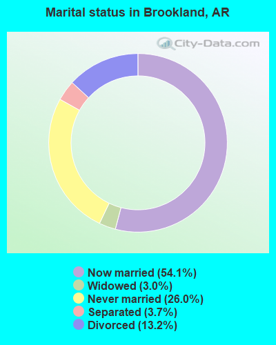
- Never married: 26.0%
- Now married: 54.1%
- Separated: 3.7%
- Widowed: 3.0%
- Divorced: 13.2%
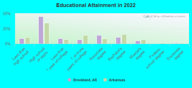
For population 25 years and over in Brookland:
- High school or higher: 87.8%
- Bachelor's degree or higher: 18.4%
- Graduate or professional degree: 5.8%
- Unemployed: 3.8%
- Mean travel time to work (commute): 22.7 minutes
| Here: | 10.5 |
| Arkansas average: | 11.4 |
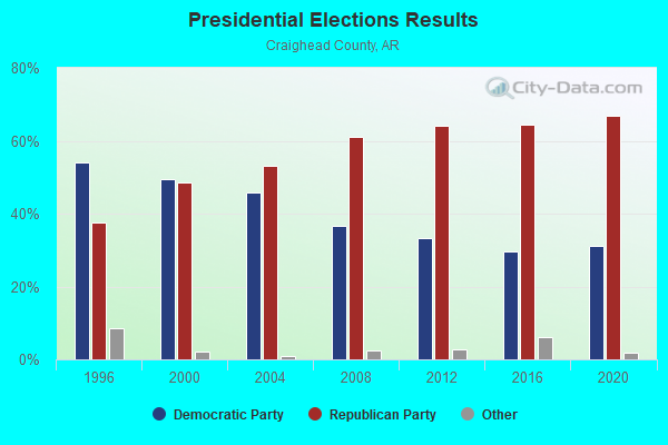
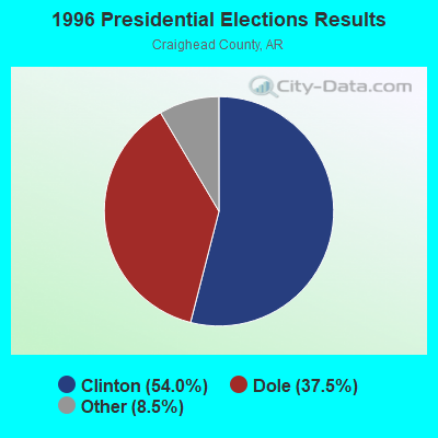
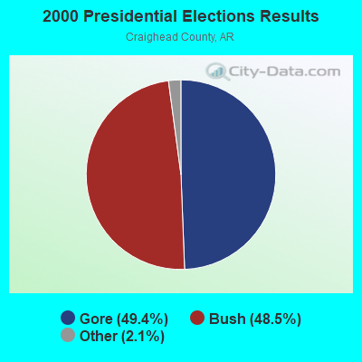
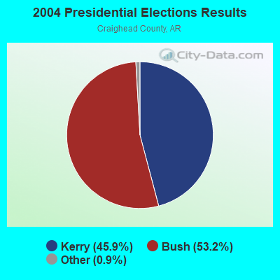
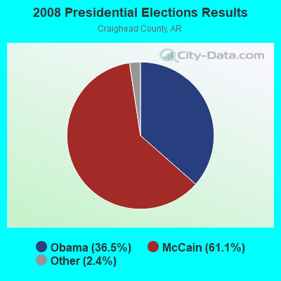
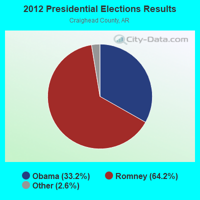
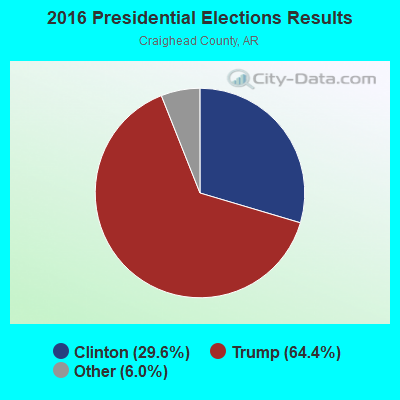
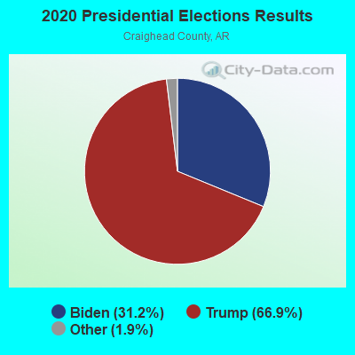
Graphs represent county-level data. Detailed 2008 Election Results
Religion statistics for Brookland, AR (based on Craighead County data)
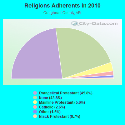
| Religion | Adherents | Congregations |
|---|---|---|
| Evangelical Protestant | 44,184 | 129 |
| Mainline Protestant | 5,408 | 24 |
| Catholic | 2,470 | 2 |
| Other | 1,477 | 10 |
| Black Protestant | 655 | 5 |
| None | 42,249 | - |
Food Environment Statistics:
| Here: | 2.42 / 10,000 pop. |
| State: | 2.02 / 10,000 pop. |
| Craighead County: | 0.33 / 10,000 pop. |
| Arkansas: | 0.25 / 10,000 pop. |
| This county: | 0.22 / 10,000 pop. |
| Arkansas: | 0.59 / 10,000 pop. |
| This county: | 4.52 / 10,000 pop. |
| Arkansas: | 4.94 / 10,000 pop. |
| Craighead County: | 8.16 / 10,000 pop. |
| Arkansas: | 6.66 / 10,000 pop. |
| Craighead County: | 8.6% |
| Arkansas: | 9.8% |
| This county: | 29.3% |
| Arkansas: | 29.1% |
| Here: | 13.4% |
| Arkansas: | 13.6% |
Health and Nutrition:
| Brookland: | 49.3% |
| Arkansas: | 48.2% |
| Brookland: | 47.4% |
| State: | 44.2% |
| Here: | 28.5 |
| Arkansas: | 28.9 |
| This city: | 22.7% |
| State: | 21.6% |
| Here: | 6.3% |
| Arkansas: | 11.3% |
| Brookland: | 6.8 |
| State: | 6.8 |
| This city: | 31.2% |
| State: | 34.0% |
| Here: | 59.1% |
| Arkansas: | 54.4% |
| This city: | 78.0% |
| Arkansas: | 78.0% |
More about Health and Nutrition of Brookland, AR Residents
| Local government employment and payroll (March 2022) | |||||
| Function | Full-time employees | Monthly full-time payroll | Average yearly full-time wage | Part-time employees | Monthly part-time payroll |
|---|---|---|---|---|---|
| Other Government Administration | 8 | $7,097 | $10,646 | 0 | $0 |
| Police Protection - Officers | 7 | $36,321 | $62,265 | 3 | $2,667 |
| Water Supply | 2 | $6,914 | $41,484 | 0 | $0 |
| Financial Administration | 2 | $7,886 | $47,316 | 0 | $0 |
| Streets and Highways | 2 | $5,947 | $35,682 | 0 | $0 |
| Other and Unallocable | 1 | $3,801 | $45,612 | 0 | $0 |
| Judicial and Legal | 1 | $600 | $7,200 | 0 | $0 |
| Sewerage | 1 | $3,860 | $46,320 | 0 | $0 |
| Totals for Government | 24 | $72,426 | $36,213 | 3 | $2,667 |
Brookland government finances - Expenditure in 2017 (per resident):
- Construction - Sewerage: $506,000 ($115.82)
Water Utilities: $502,000 ($114.90)
Central Staff Services: $6,000 ($1.37)
- Current Operations - Police Protection: $390,000 ($89.27)
Financial Administration: $244,000 ($55.85)
Water Utilities: $193,000 ($44.17)
Sewerage: $158,000 ($36.16)
Central Staff Services: $135,000 ($30.90)
Regular Highways: $102,000 ($23.35)
Local Fire Protection: $53,000 ($12.13)
Health - Other: $42,000 ($9.61)
- General - Interest on Debt: $26,000 ($5.95)
- Other Capital Outlay - Police Protection: $8,000 ($1.83)
Water Utilities: $4,000 ($0.92)
- Total Salaries and Wages: $559,000 ($127.95)
- Water Utilities - Interest on Debt: $44,000 ($10.07)
Brookland government finances - Revenue in 2017 (per resident):
- Charges - Sewerage: $293,000 ($67.06)
Other: $33,000 ($7.55)
- Local Intergovernmental - General Local Government Support: $396,000 ($90.64)
- Miscellaneous - Fines and Forfeits: $79,000 ($18.08)
General Revenue - Other: $27,000 ($6.18)
Interest Earnings: $6,000 ($1.37)
Donations From Private Sources: $1,000 ($0.23)
- Revenue - Water Utilities: $322,000 ($73.70)
- State Intergovernmental - Highways: $127,000 ($29.07)
Other: $68,000 ($15.56)
General Local Government Support: $47,000 ($10.76)
- Tax - General Sales and Gross Receipts: $226,000 ($51.73)
Public Utilities Sales: $136,000 ($31.13)
Other License: $72,000 ($16.48)
Property: $60,000 ($13.73)
Occupation and Business License - Other: $5,000 ($1.14)
Brookland government finances - Debt in 2017 (per resident):
- Long Term Debt - Outstanding Unspecified Public Purpose: $5,940,000 ($1359.58)
Issue, Unspecified Public Purpose: $4,724,000 ($1081.25)
Beginning Outstanding - Unspecified Public Purpose: $1,216,000 ($278.32)
Brookland government finances - Cash and Securities in 2017 (per resident):
- Bond Funds - Cash and Securities: $3,516,000 ($804.76)
- Other Funds - Cash and Securities: $1,133,000 ($259.33)
- Sinking Funds - Cash and Securities: $160,000 ($36.62)
Businesses in Brookland, AR
- Subway: 1
- U-Haul: 1
Strongest AM radio stations in Brookland:
- KBTM (1230 AM; 1 kW; JONESBORO, AR; Owner: CAPSTAR TX LIMITED PARTNERSHIP)
- WDIA (1070 AM; 50 kW; MEMPHIS, TN; Owner: CLEAR CHANNEL BROADCASTING LICENSES, INC.)
- WCRV (640 AM; 50 kW; COLLIERVILLE, TN; Owner: BOTT BROADCASTING COMPANY/TENNESSEE)
- KNEA (970 AM; 1 kW; JONESBORO, AR; Owner: CLEAR CHANNEL BROADCASTING LICENSES, INC.)
- WGSF (1030 AM; 50 kW; MEMPHIS, TN; Owner: FLINN BROADCASTING CORPORATION)
- KOTC (830 AM; daytime; 10 kW; KENNETT, MO; Owner: EAGLE BLUFF ENTERPRISES)
- WMQM (1600 AM; 50 kW; LAKELAND, TN; Owner: WMQM, INC.)
- KDRS (1490 AM; 1 kW; PARAGOULD, AR; Owner: MOR MEDIA, INC.)
- WJCE (680 AM; 10 kW; MEMPHIS, TN; Owner: ENTERCOM MEMPHIS LICENSE, LLC)
- KLCN (910 AM; 5 kW; BLYTHEVILLE, AR; Owner: SUDBURY SERVICES, INC.)
- KGHT (880 AM; 50 kW; SHERIDAN, AR; Owner: METROPOLITAN RADIO GROUP, INC.)
- KWAM (990 AM; 10 kW; MEMPHIS, TN; Owner: CONCORD MEDIA GROUP, INC.)
- WHBQ (560 AM; 5 kW; MEMPHIS, TN; Owner: FLINN BROADCASTING CORPORATION)
Strongest FM radio stations in Brookland:
- KDXY (104.9 FM; LAKE CITY, AR; Owner: SAGA COMMUNICATIONS OF ARKANSAS, LLC)
- KIYS (101.9 FM; JONESBORO, AR; Owner: ,CAPSTAR TX LIMITED PARTNERSHIP)
- KDEZ (100.5 FM; JONESBORO, AR; Owner: SAGA COMMUNICATIONS OF ARKANSAS, LLC)
- KASU (91.9 FM; JONESBORO, AR; Owner: ARKANSAS STATE UNIVERSITY)
- KFIN (107.9 FM; JONESBORO, AR; Owner: CAPSTAR TX LIMITED PARTNERSHIP)
- KDRS-FM (107.1 FM; PARAGOULD, AR; Owner: MOR MEDIA, INC.)
- WJZN (98.9 FM; MUNFORD, TN; Owner: MEMPHIS III LIMITED PARTNERSHIP)
- KBZR (95.9 FM; HARRISBURG, AR; Owner: CLEAR CHANNEL BROADCASTING LICENSES, INC.)
- KJBX (106.7 FM; TRUMANN, AR; Owner: SAGA COMMUNICATIONS OF ARKANSAS, LLC)
- KAOG (90.5 FM; JONESBORO, AR; Owner: AMERICAN FAMILY ASSOCIATION)
- WYPL (89.3 FM; MEMPHIS, TN; Owner: MEMPHIS/SHELBY COUNTY PUBLIC LIBRARY & INFO CNTR.)
- KJLV (105.3 FM; HOXIE, AR; Owner: EDUCATIONAL MEDIA FOUNDATION)
- KAUF (89.9 FM; KENNETT, MO; Owner: AMERICAN FAMILY ASSOCIATION)
- K218DE (91.5 FM; JONESBORO, AR; Owner: CALVARY CHAPEL OF TWIN FALLS, INC.)
- K202CG (88.3 FM; JONESBORO, AR; Owner: FAMILY STATIONS, INC.)
TV broadcast stations around Brookland:
- K46EM (Channel 46; BATESVILLE, AR; Owner: MS COMMUNICATIONS, LLC)
- K54ER (Channel 54; JONESBORO, AR; Owner: TRINITY BROADCASTING NETWORK)
- KTEJ (Channel 19; JONESBORO, AR; Owner: ARKANSAS EDUCATIONAL TELEVISION COMMISSION)
- KAIT (Channel 8; JONESBORO, AR; Owner: LIBCO, INC.)
- KVTJ (Channel 48; JONESBORO, AR; Owner: AGAPE CHURCH, INC.)
- K27FC (Channel 27; PARAGOULD, AR; Owner: TRINITY BROADCASTING NETWORK)
Brookland fatal accident list:
Jul 14, 2015 06:05 PM, Us-49-03b, Cs- School St., Lat: 35.907361, Lon: -90.577231, Vehicles: 2, Persons: 3, Fatalities: 1
Jun 30, 2012 09:28 PM, Us-49, Lat: 35.890519, Lon: -90.589294, Vehicles: 1, Persons: 1, Pedestrians: 1, Fatalities: 1
Nov 5, 2010 05:19 PM, School St., Bernis, Lat: 35.907336, Lon: -90.581611, Vehicles: 2, Persons: 4, Fatalities: 1
Aug 30, 2002 10:51 PM, Bernis, Vehicles: 1, Persons: 1, Fatalities: 1
Dec 16, 1983 05:40 PM, 49, Vehicles: 1, Persons: 3, Fatalities: 1
- National Bridge Inventory (NBI) Statistics
- 47Number of bridges
- 289ft / 88.0mTotal length
- $1,961,000Total costs
- 136,880Total average daily traffic
- 2,814Total average daily truck traffic
- 176,583Total future (year 2004) average daily traffic
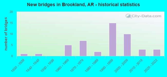
- New bridges - historical statistics
- 11930-1939
- 11940-1949
- 51960-1969
- 71970-1979
- 21980-1989
- 151990-1999
- 102000-2009
- 32010-2019
- 32020-2022
FCC Registered Antenna Towers:
49 (See the full list of FCC Registered Antenna Towers in Brookland)FCC Registered Broadcast Land Mobile Towers:
1- 102 Cr 968 (Lat: 35.901389 Lon: -90.580833), Call Sign: WPXV959,
Assigned Frequencies: 159.810 MHz, Grant Date: 05/23/2013, Expiration Date: 06/19/2023, Cancellation Date: 08/19/2023, Certifier: Terry Grimes, Registrant: Poinsett Communications, Inc., 2100 Wingate Drive, Jonesboro, AR 72404-0600, Phone: (870) 933-9284, Email:
FCC Registered Microwave Towers:
2- LR54XC437, 2905 Cr 712 (Lat: 35.904556 Lon: -90.614083), Type: Gtower, Structure height: 94.5 m, Call Sign: WQRI866,
Assigned Frequencies: 10855.0 MHz, 10855.0 MHz, 10855.0 MHz, 10855.0 MHz, 10855.0 MHz, 10855.0 MHz, 19575.0 MHz, 19575.0 MHz, 19575.0 MHz, 19575.0 MHz, 19575.0 MHz, 19575.0 MHz, Grant Date: 05/23/2013, Expiration Date: 05/23/2023, Cancellation Date: 04/28/2023, Certifier: David Werblow, Registrant: T-Mobile Usa, Inc., 12920 Se 38th Street, Bellevue, WA 98006, Phone: (425) 383-8401, Email:
- LR54XC438, 1096 Highway 49 North (Lat: 35.948583 Lon: -90.575917), Type: Ltower, Structure height: 91.4 m, Overall height: 96 m, Call Sign: WQRT660,
Assigned Frequencies: 18015.0 MHz, 18015.0 MHz, 18015.0 MHz, 18015.0 MHz, 18015.0 MHz, 18015.0 MHz, Grant Date: 07/24/2013, Expiration Date: 07/24/2023, Cancellation Date: 05/16/2023, Certifier: David Werblow, Registrant: T-Mobile Usa, Inc., 12920 Se 38th Street, Bellevue, WA 98006, Phone: (425) 383-8401, Email:
FCC Registered Amateur Radio Licenses:
30 (See the full list of FCC Registered Amateur Radio Licenses in Brookland)FAA Registered Aircraft:
1- Aircraft: CESSNA 172L (Category: Land, Seats: 4, Weight: Up to 12,499 Pounds, Speed: 105 mph), Engine: LYCOMING 0-320 SERIES (180 HP) (Reciprocating)
N-Number: 1077M, N1077M, N-1077M, Serial Number: 17259477, Year manufactured: 1970, Airworthiness Date: 10/16/1970, Certificate Issue Date: 01/13/2010
Registrant (Partnership): James Petit, 122 County Road 736, Brookland, AR 72417, Other Owners: Josephine M Petit
Deregistered: Cancel Date: 01/09/2018
| Home Mortgage Disclosure Act Aggregated Statistics For Year 2009 (Based on 1 partial tract) | ||||
| A) FHA, FSA/RHS & VA Home Purchase Loans | C) Refinancings | |||
|---|---|---|---|---|
| Number | Average Value | Number | Average Value | |
| LOANS ORIGINATED | 1 | $52,300 | 1 | $177,430 |
| APPLICATIONS APPROVED, NOT ACCEPTED | 0 | $0 | 0 | $0 |
| APPLICATIONS DENIED | 0 | $0 | 0 | $0 |
| APPLICATIONS WITHDRAWN | 0 | $0 | 0 | $0 |
| FILES CLOSED FOR INCOMPLETENESS | 0 | $0 | 0 | $0 |
Detailed HMDA statistics for the following Tracts: 0011.00
2002 - 2018 National Fire Incident Reporting System (NFIRS) incidents
- Fire incident types reported to NFIRS in Brookland, AR
- 15851.3%Outside Fires
- 11437.0%Structure Fires
- 278.8%Mobile Property/Vehicle Fires
- 92.9%Other
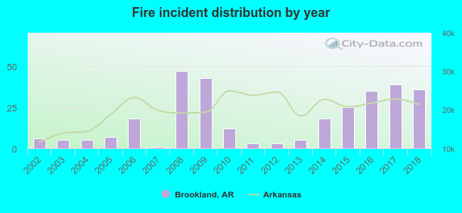 Based on the data from the years 2002 - 2018 the average number of fire incidents per year is 18. The highest number of reported fire incidents - 47 took place in 2008, and the least - 1 in 2007. The data has a growing trend.
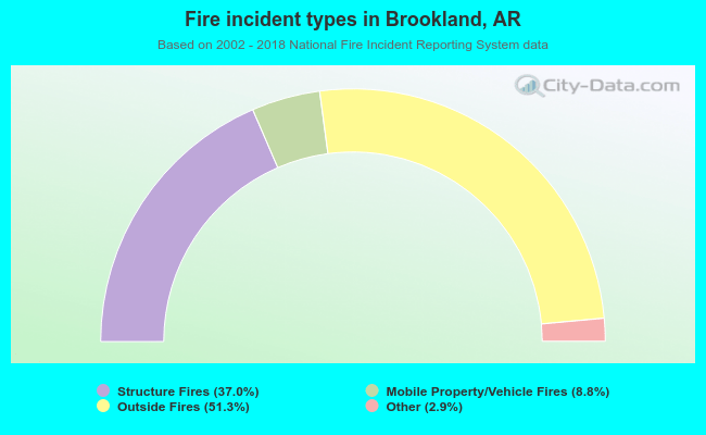 When looking into fire subcategories, the most incidents belonged to: Outside Fires (51.3%), and Structure Fires (37.0%).
| Most common first names in Brookland, AR among deceased individuals | ||
| Name | Count | Lived (average) |
|---|---|---|
| John | 21 | 76.6 years |
| James | 19 | 76.5 years |
| William | 17 | 76.4 years |
| Robert | 14 | 67.3 years |
| Mary | 12 | 76.6 years |
| Charles | 10 | 73.7 years |
| George | 10 | 73.6 years |
| Thomas | 8 | 77.7 years |
| Ray | 7 | 77.7 years |
| Ethel | 5 | 83.8 years |
| Most common last names in Brookland, AR among deceased individuals | ||
| Last name | Count | Lived (average) |
|---|---|---|
| Smith | 20 | 70.3 years |
| Adams | 15 | 73.3 years |
| Gambill | 11 | 77.3 years |
| Robinson | 10 | 84.3 years |
| Jones | 10 | 74.6 years |
| Nelms | 9 | 82.9 years |
| Lawrence | 8 | 69.9 years |
| Johnston | 8 | 83.4 years |
| Brown | 8 | 74.9 years |
| Williams | 7 | 61.0 years |
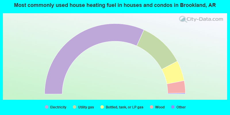
- 63.8%Electricity
- 21.2%Utility gas
- 9.4%Bottled, tank, or LP gas
- 5.7%Wood
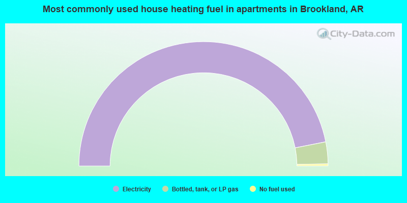
- 93.7%Electricity
- 5.7%Bottled, tank, or LP gas
- 0.5%No fuel used
Brookland compared to Arkansas state average:
- Unemployed percentage significantly below state average.
- Black race population percentage below state average.
- Hispanic race population percentage below state average.
- Median age below state average.
- Foreign-born population percentage below state average.
- Length of stay since moving in below state average.
- House age below state average.
- Number of college students significantly above state average.

|
Total of 4 patent applications in 2008-2024.