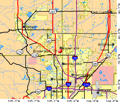
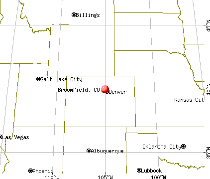
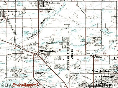
Broomfield, Colorado
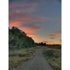
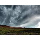
Broomfield: Broomfield Sunset

Broomfield: Broomfield Sunset (Tom Frost Reservoir)
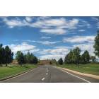
Broomfield: Broomfield Road

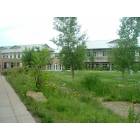
Broomfield: Broomfield Landscape

Broomfield: Broomfield Sunset
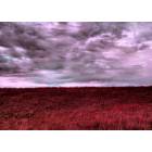
Broomfield: Broomfield Landscape
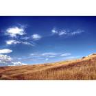
Broomfield: Broomfield Landscape
Broomfield: Sun Microsystems campus in Broomfield
Broomfield: Broomfield Landscape
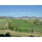
Broomfield: View of Omni Interlocken Golf Course
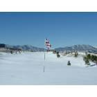
Broomfield: View from Camden Interlocken Apartments Balcony
- see
19
more - add
your
Submit your own pictures of this city and show them to the world
- OSM Map
- General Map
- Google Map
- MSN Map
Population change since 2000: +98.9%
| Males: 38,462 | |
| Females: 37,659 |
| Median resident age: | 38.9 years |
| Colorado median age: | 37.7 years |
Zip codes: 80020, 80023, 80027, 80234, 80516.
Broomfield Zip Code Map| Broomfield: | $115,833 |
| CO: | $89,302 |
Estimated per capita income in 2022: $58,850 (it was $26,488 in 2000)
Broomfield city income, earnings, and wages data
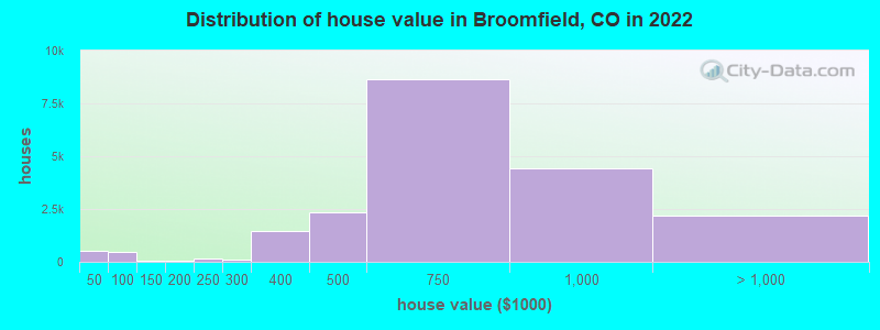
Estimated median house or condo value in 2022: $644,200 (it was $182,200 in 2000)
| Broomfield: | $644,200 |
| CO: | $531,100 |
Mean prices in 2022: all housing units: $653,036; detached houses: $700,522; townhouses or other attached units: $450,760; in 5-or-more-unit structures: $331,639; mobile homes: $76,082
Median gross rent in 2022: $1,952.
(4.3% for White Non-Hispanic residents, 5.7% for Black residents, 10.7% for Hispanic or Latino residents, 7.4% for American Indian residents, 2.0% for other race residents, 10.4% for two or more races residents)
Detailed information about poverty and poor residents in Broomfield, CO


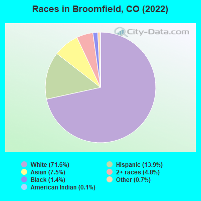
- 54,49171.6%White alone
- 10,57113.9%Hispanic
- 5,7147.5%Asian alone
- 3,6524.8%Two or more races
- 1,0481.4%Black alone
- 5380.7%Other race alone
- 1070.1%American Indian alone
According to our research of Colorado and other state lists, there were 61 registered sex offenders living in Broomfield, Colorado as of April 26, 2024.
The ratio of all residents to sex offenders in Broomfield is 1,048 to 1.
The ratio of registered sex offenders to all residents in this city is lower than the state average.
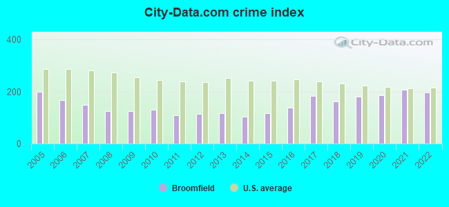
The City-Data.com crime index weighs serious crimes and violent crimes more heavily. Higher means more crime, U.S. average is 246.1. It adjusts for the number of visitors and daily workers commuting into cities.
- means the value is smaller than the state average.- means the value is about the same as the state average.
- means the value is bigger than the state average.
- means the value is much bigger than the state average.
Crime rate in Broomfield detailed stats: murders, rapes, robberies, assaults, burglaries, thefts, arson
Full-time law enforcement employees in 2021, including police officers: 226 (120 officers - 96 male; 24 female).
| Officers per 1,000 residents here: | 1.64 |
| Colorado average: | 2.14 |
 Recent articles from our blog. Our writers, many of them Ph.D. graduates or candidates, create easy-to-read articles on a wide variety of topics.

 | Which is good desi community place to move near Broomfield (4 replies) |
| Retirement in Broomfield? (9 replies) |
| Chicago -> Broomfield Area (30 replies) |
| Moving to Broomfield in a few months (Build or Buy?) (7 replies) |
| Arvada (West Woods), Golden (Tablerock) or Broomfield (McKay/Broadlands) (10 replies) |
| Broomfield One of The Best Places to Retire (19 replies) |
Latest news from Broomfield, CO collected exclusively by city-data.com from local newspapers, TV, and radio stations
Broomfield, CO City Guides:
Ancestries: German (12.4%), English (8.8%), European (7.0%), Irish (6.5%), American (6.4%), Italian (3.5%).
Current Local Time: MST time zone
Incorporated on 6/1961
Elevation: 5400 feet
Land area: 27.1 square miles.
Population density: 2,808 people per square mile (average).
8,024 residents are foreign born (5.0% Asia, 3.0% Latin America, 1.7% Europe).
| This city: | 10.9% |
| Colorado: | 9.5% |
Median real estate property taxes paid for housing units with mortgages in 2022: $3,880 (0.6%)
Median real estate property taxes paid for housing units with no mortgage in 2022: $3,675 (0.6%)
Nearest city with pop. 50,000+: Westminster, CO  (4.1 miles , pop. 100,940).
Nearest city with pop. 200,000+: West Adams, CO (5.6 miles , pop. 259,628).
Nearest city with pop. 1,000,000+: Phoenix, AZ (588.8 miles , pop. 1,321,045).
Nearest cities:
), )Latitude: 39.93 N, Longitude: 105.07 W
Daytime population change due to commuting: +6,102 (+8.0%)
Workers who live and work in this city: 19,346 (46.3%)
Broomfield tourist attractions:
Broomfield, Colorado accommodation & food services, waste management - Economy and Business Data
| Here: | 3.2% |
| Colorado: | 3.2% |
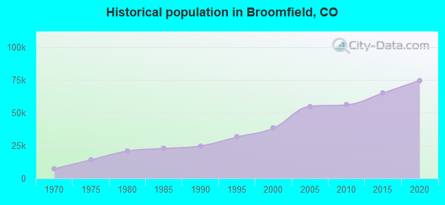
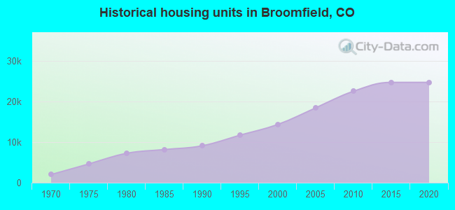
Population change in the 1990s: +13,214 (+52.7%).
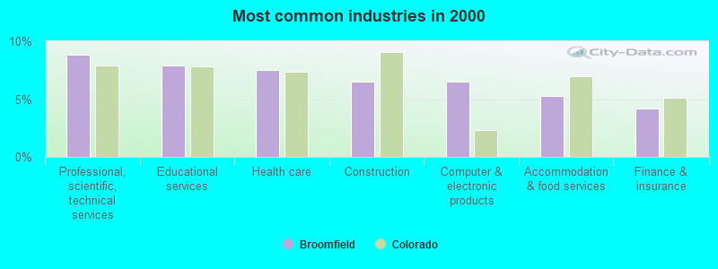
- Professional, scientific, technical services (8.8%)
- Educational services (7.9%)
- Health care (7.5%)
- Construction (6.5%)
- Computer & electronic products (6.5%)
- Accommodation & food services (5.3%)
- Finance & insurance (4.2%)
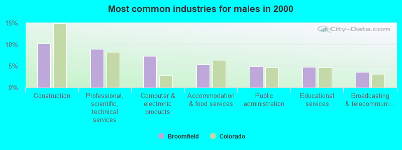
- Construction (10.3%)
- Professional, scientific, technical services (8.9%)
- Computer & electronic products (7.3%)
- Accommodation & food services (5.3%)
- Public administration (4.9%)
- Educational services (4.8%)
- Broadcasting & telecommunications (3.6%)
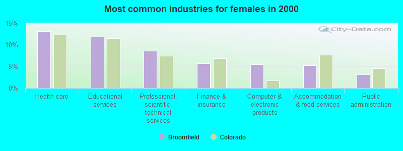
- Health care (13.1%)
- Educational services (11.8%)
- Professional, scientific, technical services (8.7%)
- Finance & insurance (5.7%)
- Computer & electronic products (5.4%)
- Accommodation & food services (5.2%)
- Public administration (3.2%)
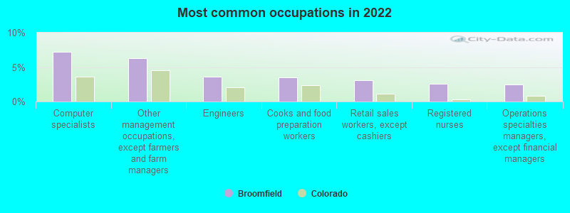
- Computer specialists (7.2%)
- Other management occupations, except farmers and farm managers (6.3%)
- Engineers (3.6%)
- Cooks and food preparation workers (3.5%)
- Retail sales workers, except cashiers (3.1%)
- Registered nurses (2.6%)
- Operations specialties managers, except financial managers (2.5%)
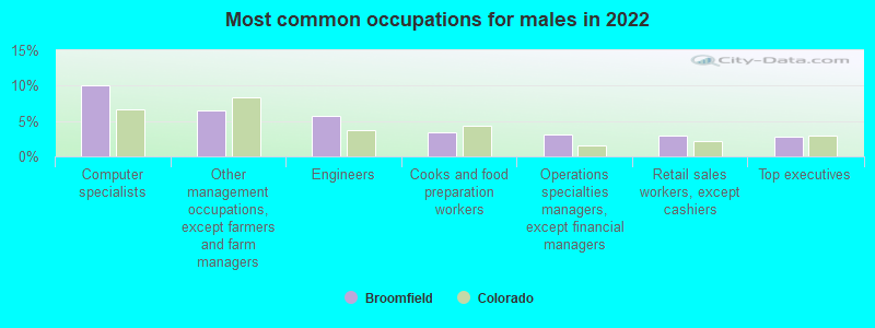
- Computer specialists (10.1%)
- Other management occupations, except farmers and farm managers (6.5%)
- Engineers (5.8%)
- Cooks and food preparation workers (3.3%)
- Operations specialties managers, except financial managers (3.2%)
- Retail sales workers, except cashiers (3.0%)
- Top executives (2.7%)
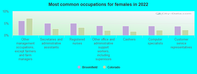
- Other management occupations, except farmers and farm managers (6.0%)
- Secretaries and administrative assistants (5.1%)
- Registered nurses (5.1%)
- Other office and administrative support workers, including supervisors (4.1%)
- Cashiers (3.9%)
- Computer specialists (3.9%)
- Customer service representatives (3.8%)
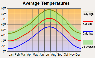
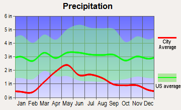
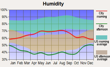
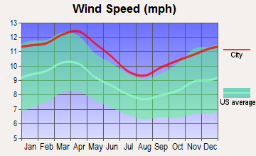
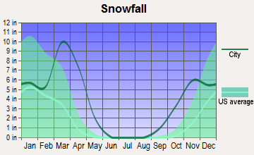
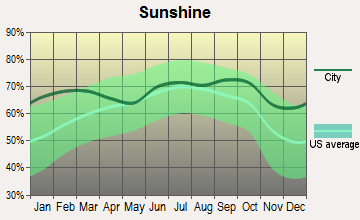
Average climate in Broomfield, Colorado
Based on data reported by over 4,000 weather stations

|
|

(lower is better)
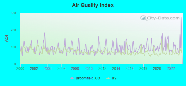
Air Quality Index (AQI) level in 2023 was 122. This is significantly worse than average.
| City: | 122 |
| U.S.: | 73 |

Carbon Monoxide (CO) [ppm] level in 2023 was 0.292. This is about average. Closest monitor was 8.9 miles away from the city center.
| City: | 0.292 |
| U.S.: | 0.251 |
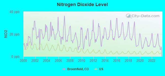
Nitrogen Dioxide (NO2) [ppb] level in 2023 was 10.9. This is significantly worse than average. Closest monitor was 6.5 miles away from the city center.
| City: | 10.9 |
| U.S.: | 5.1 |
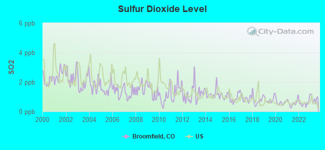
Sulfur Dioxide (SO2) [ppb] level in 2023 was 0.864. This is significantly better than average. Closest monitor was 8.9 miles away from the city center.
| City: | 0.864 |
| U.S.: | 1.515 |
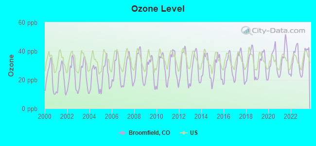
Ozone [ppb] level in 2023 was 36.8. This is about average. Closest monitor was 7.2 miles away from the city center.
| City: | 36.8 |
| U.S.: | 33.3 |
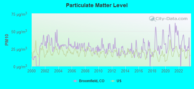
Particulate Matter (PM10) [µg/m3] level in 2023 was 26.5. This is worse than average. Closest monitor was 4.3 miles away from the city center.
| City: | 26.5 |
| U.S.: | 19.2 |

Particulate Matter (PM2.5) [µg/m3] level in 2023 was 8.26. This is about average. Closest monitor was 9.9 miles away from the city center.
| City: | 8.26 |
| U.S.: | 8.11 |
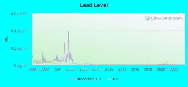
Lead (Pb) [µg/m3] level in 2009 was 0.00502. This is significantly better than average. Closest monitor was 7.3 miles away from the city center.
| City: | 0.00502 |
| U.S.: | 0.00931 |
Tornado activity:
Broomfield-area historical tornado activity is above Colorado state average. It is 24% greater than the overall U.S. average.
On 6/15/1988, a category F3 (max. wind speeds 158-206 mph) tornado 15.7 miles away from the Broomfield city center injured 7 people and caused between $5,000,000 and $50,000,000 in damages.
On 5/18/1975, a category F3 tornado 20.0 miles away from the city center .
Earthquake activity:
Broomfield-area historical earthquake activity is significantly above Colorado state average. It is 715% greater than the overall U.S. average.On 8/18/1959 at 06:37:13, a magnitude 7.7 (7.7 UK, Class: Major, Intensity: VIII - XII) earthquake occurred 429.5 miles away from the city center, causing $26,000,000 total damage
On 10/18/1984 at 15:30:23, a magnitude 5.5 (5.4 MB, 5.1 MS, 5.5 ML, Class: Moderate, Intensity: VI - VII) earthquake occurred 172.4 miles away from Broomfield center
On 10/28/1983 at 14:06:06, a magnitude 7.3 (6.2 MB, 7.3 MS, 7.0 MW) earthquake occurred 532.3 miles away from Broomfield center, causing 2 deaths (2 shaking deaths) and 3 injuries, causing $15,000,000 total damage
On 8/23/2011 at 05:46:18, a magnitude 5.3 (5.3 MW, Depth: 2.5 mi) earthquake occurred 199.4 miles away from Broomfield center
On 3/28/1975 at 02:31:05, a magnitude 6.2 (6.1 MB, 6.0 MS, 6.2 ML, Class: Strong, Intensity: VII - IX) earthquake occurred 412.6 miles away from Broomfield center
On 2/3/1995 at 15:26:10, a magnitude 5.3 (5.3 MB, 4.6 MS, Depth: 0.6 mi) earthquake occurred 263.9 miles away from Broomfield center
Magnitude types: body-wave magnitude (MB), local magnitude (ML), surface-wave magnitude (MS), moment magnitude (MW)
Natural disasters:
The number of natural disasters in Jefferson County (12) is smaller than the US average (15).Major Disasters (Presidential) Declared: 4
Emergencies Declared: 4
Causes of natural disasters: Fires: 4, Floods: 4, Storms: 3, Landslides: 2, Mudslides: 2, Snows: 2, Heavy Rain: 1, Hurricane: 1, Snowstorm: 1, Other: 1 (Note: some incidents may be assigned to more than one category).
Main business address for: GAIAM INC (SERVICES-MOTION PICTURE & VIDEO TAPE PRODUCTION), SIRENZA MICRODEVICES INC (SEMICONDUCTORS & RELATED DEVICES), BALL CORP (METAL CANS), LEVEL 3 COMMUNICATIONS INC (TELEPHONE COMMUNICATIONS (NO RADIO TELEPHONE)), MCDATA CORP (COMMUNICATIONS EQUIPMENT, NEC).
Hospitals and medical centers in Broomfield:
- COMPASSIONATE HOME HEALTH CARE LLC (11940 QUAY STREET)
- BROOMFIELD SKILLED NURSING AND REHABILITATION CTR (12975 SHERIDAN BOULEVARD)
Other hospitals and medical centers near Broomfield:
- SATURDAY PARTNERS LLC (Home Health Center, about 4 miles away; WESTMINSTER, CO)
- NORTH METRO DENVER DIALYSIS (DVA) (Dialysis Facility, about 4 miles away; WESTMINSTER, CO)
- CENTURA HEALTH-AVISTA ADVENTIST HOSPITAL Acute Care Hospitals (about 5 miles away; LOUISVILLE, CO)
- WESTMINSTER DIALYSIS (DVA) (Dialysis Facility, about 5 miles away; WESTMINSTER, CO)
- VILLAGE CARE AND REHABILITATION CENTER, THE (Nursing Home, about 5 miles away; WESTMINSTER, CO)
- COVENANTCARE AT HOME (Home Health Center, about 5 miles away; WESTMINSTER, CO)
- MAXIM HEALTHCARE SERVICES WESTMINSTER (Home Health Center, about 5 miles away; WESTMINSTER, CO)
Heliports located in Broomfield:
Amtrak stations near Broomfield:
- 13 miles: DENVER (1701 WYNKOOP ST.) . Services: ticket office, fully wheelchair accessible, enclosed waiting area, public restrooms, public payphones, full-service food facilities and snack bar, paid short-term parking, paid long-term parking, call for car rental service, taxi stand, public transit connection.
- 15 miles: BOULDER (4401 N. BROADWAY) - Bus Station . Services: enclosed waiting area, public payphones, snack bar.
- 17 miles: LONGMONT (615 N. MAUB ST.) - Bus Station
College/University in Broomfield:
Colleges/universities with over 2000 students nearest to Broomfield:
- Front Range Community College (about 3 miles; Westminster, CO; Full-time enrollment: 14,756)
- Regis University (about 10 miles; Denver, CO; FT enrollment: 6,975)
- University of Colorado Boulder (about 12 miles; Boulder, CO; FT enrollment: 28,328)
- University of Colorado Denver (about 14 miles; Denver, CO; FT enrollment: 14,727)
- Metropolitan State University of Denver (about 14 miles; Denver, CO; FT enrollment: 17,242)
- Community College of Denver (about 14 miles; Denver, CO; FT enrollment: 7,329)
- Emily Griffith Technical College (about 14 miles; Denver, CO; FT enrollment: 2,460)
Public high schools in Broomfield:
- LEGACY HIGH SCHOOL (Students: 1,918, Location: 2701 WEST 136TH STREET, Grades: 9-12)
- BROOMFIELD HIGH SCHOOL (Students: 1,440, Location: 1 EAGLE WAY, Grades: 9-12)
- JEFFERSON CHARTER ACADEMY SENIOR HIGH SCHOOL (Students: 267, Location: 11251 REED WAY, Grades: 9-12, Charter school)
- JEFFERSON CHARTER ACADEMY JUNIOR HIGH SCHOOL (Students: 152, Location: 11251 REED WAY, Grades: KG-12, Charter school)
- PROSPECT RIDGE ACADEMY (Location: 2555 PREBLE CREEK PKWY, Grades: KG-9, Charter school)
Private high school in Broomfield:
Biggest public elementary/middle schools in Broomfield:
- ASPEN CREEK K-8 SCHOOL (Students: 912, Location: 5500 ASPEN CREEK DRIVE, Grades: PK-8)
- WESTLAKE MIDDLE SCHOOL (Students: 883, Location: 2800 WEST 135TH AVENUE, Grades: 6-8)
- MERIDIAN ELEMENTARY SCHOOL (Students: 639, Location: 14256 MCKAY PARK CIRCLE, Grades: KG-5)
- MOUNTAIN VIEW ELEMENTARY SCHOOL (Students: 630, Location: 12401 PERRY STREET, Grades: KG-5)
- CENTENNIAL ELEMENTARY SCHOOL (Students: 558, Location: 13200 WESTLAKE DRIVE, Grades: KG-5)
- BROOMFIELD HEIGHTS MIDDLE SCHOOL (Students: 523, Location: 1555 DAPHNE STREET, Grades: 6-8)
- COYOTE RIDGE ELEMENTARY SCHOOL (Students: 501, Location: 13770 BROADLANDS DRIVE, Grades: KG-5)
- KOHL ELEMENTARY SCHOOL (Students: 476, Location: 1000 WEST 10TH AVENUE, Grades: PK-5)
- BIRCH ELEMENTARY SCHOOL (Students: 436, Location: 1035 BIRCH, Grades: PK-5)
- EMERALD ELEMENTARY SCHOOL (Students: 395, Location: 755 W. ELMHURST PLACE, Grades: PK-5)
Private elementary/middle schools in Broomfield:
- NATIVITY OF OUR LORD SCHOOL (Students: 465, Location: 900 W MIDWAY BLVD, Grades: PK-8)
- BEAUTIFUL SAVIOR LUTHERAN SCHOOL (Students: 156, Location: 6995 W 120TH AVE, Grades: PK-8)
- BROOMFIELD ACADEMY (Students: 125, Location: 7203 W 120TH AVE, Grades: PK-6)
- SHEPHERD OF THE VALLEY LUTHERAN SCHOOL (Students: 98, Location: 8997 W 88TH AVE, Grades: PK-8)
Library in Broomfield:
Points of interest:
Notable locations in Broomfield: Eagle Terrace Golf Club (A), Hillside Convenience Center (B), Broomfield Retail Center (C), Broadlands Golf Course (D), Greenway Park Golf Course (E), Ideal Industrial Park (F), Turnpike Industrial Park (G), Interlocken Office Park (H), Eagle Country Club (I), Omni Interlocken Resort Golf Club (J), Eagle Trace Golf Club (K), Broomfield Police Department Detention Division (L), Broomfield Recreation Center (M), Western Ambulance (N), Buffalo Ridge Medical Center (O), Broomfield Courthouse (P), Broomfield Police Department Headquarters (Q), Broomfield City Hall (R), Mamie Doud Eisenhower Public Library (S), Colorado State Patrol Office - District Six (T). Display/hide their locations on the map
Shopping Centers: Broomfield Plaza Shopping Center (1), Villager Square Shopping Center (2), Greenway Shopping Center (3), Broomfield Shopping Center (4), Flatiron Crossing Mall Shopping Center (5). Display/hide their locations on the map
Main business address in Broomfield include: GAIAM INC (A), SIRENZA MICRODEVICES INC (B), BALL CORP (C), LEVEL 3 COMMUNICATIONS INC (D), MCDATA CORP (E). Display/hide their locations on the map
Churches in Broomfield include: Broomfield Assembly of God Church (A), Presbyterian Church of Broomfield (B), Broomfield United Methodist Church (C), Broomfield Community Church (D), The Church of Jesus Christ of Latter Day Saints (E). Display/hide their locations on the map
Cemeteries: Broomfield County Commons Cemetery (1), Lakeview Cemetery (2), Evergreen Memorial Gardens (3). Display/hide their locations on the map
Reservoirs: Le Gault Reservoir (A), Plaster Reservoir (B), Great Western Reservoir (C), West Lake (D), Tom Frost Reservoir (E), Brunner Reservoir (F), Broomfield Reservoir (G), Nissen Reservoir Number 2 (H). Display/hide their locations on the map
Parks in Broomfield include: Highland Park (1), Columbine Meadows Park (2), Country Estates Park (3), Hunter Douglas Business Park (4), Blue Star Memorial Park (5), Richard Steele Park (6), Birch Park (7), Brandywine Park (8), Cottonwood Park (9). Display/hide their locations on the map
Hotels: Extended Stay Opco-Flat Iron (480 Flatiron Boulevard) (1), La Quinta Inn and Suites Westminster (10179 Church Ranch Way) (2), LA Quinta Inn & Suites Westminster Promenade (10179 Church Ranch Way) (3). Display/hide their approximate locations on the map
Court: Broomfield Government Court (17 Descombes Drive) (1). Display/hide its approximate location on the map
Drinking water stations with addresses in Broomfield and their reported violations in the past:
MILE HIGH WATER COMPANY (Population served: 700, Purch surface water):Past monitoring violations:
- Monitoring and Reporting (DBP) - Between JUL-2014 and SEP-2014, Contaminant: Chlorine. Follow-up actions: St Public Notif requested (SEP-10-2014), St Violation/Reminder Notice (SEP-10-2014), St Compliance achieved (SEP-24-2014)
- Monitoring and Reporting (DBP) - Between APR-2009 and JUN-2009, Contaminant: Chlorine. Follow-up actions: St Public Notif requested (AUG-10-2009), St Violation/Reminder Notice (AUG-10-2009), St Compliance achieved (SEP-10-2009)
- Follow-up Or Routine LCR Tap M/R - In OCT-01-2008, Contaminant: Lead and Copper Rule. Follow-up actions: St Public Notif requested (NOV-11-2008), St Violation/Reminder Notice (NOV-11-2008), St Compliance achieved (NOV-03-2009)
- Initial Tap Sampling for Pb and Cu - In JUL-01-2006, Contaminant: Lead and Copper Rule. Follow-up actions: St Public Notif requested (SEP-08-2006), St Violation/Reminder Notice (SEP-08-2006), St Public Notif requested (NOV-29-2006), St AO (w/o penalty) issued (NOV-29-2006), St Compliance achieved (AUG-25-2008)
- Initial Tap Sampling for Pb and Cu - In JAN-01-2006, Contaminant: Lead and Copper Rule. Follow-up actions: St Violation/Reminder Notice (MAR-15-2006), St Public Notif requested (MAR-15-2006), St AO (w/o penalty) issued (NOV-29-2006), St Public Notif requested (NOV-29-2006), St Compliance achieved (AUG-25-2008)
- 8 routine major monitoring violations
- One other older monitoring violation
Drinking water stations with addresses in Broomfield that have no violations reported:
- BROOMFIELD CITY AND COUNTY OF (Population served: 87,104, Primary Water Source Type: Surface water)
| This city: | 2.6 people |
| Colorado: | 2.5 people |
| This city: | 69.3% |
| Whole state: | 63.9% |
| This city: | 5.4% |
| Whole state: | 6.5% |
Likely homosexual households (counted as self-reported same-sex unmarried-partner households)
- Lesbian couples: 0.5% of all households
- Gay men: 0.3% of all households
People in group quarters in Broomfield in 2010:
- 207 people in nursing facilities/skilled-nursing facilities
- 72 people in local jails and other municipal confinement facilities
- 3 people in other noninstitutional facilities
Banks with most branches in Broomfield (2011 data):
- U.S. Bank National Association: 136th & Zuni King Soopers Branch, Miramonte & Hwy 287 King Soopers Bra, Interlocken Branch, Broomfield Branch, Larkridge Branch, Broadlands Safeway. Info updated 2012/01/30: Bank assets: $330,470.8 mil, Deposits: $236,091.5 mil, headquarters in Cincinnati, OH, positive income, 3121 total offices, Holding Company: U.S. Bancorp
- First National Bank of Omaha: Flatiron Crossing Mall Retail Center, Broomfield Branch, Flatiron Crossing Branch. Info updated 2010/10/13: Bank assets: $13,433.1 mil, Deposits: $10,746.6 mil, headquarters in Omaha, NE, positive income, Commercial Lending Specialization, 102 total offices, Holding Company: Lauritzen Corporation
- FirstBank: 136th And Zuni Branch at 2155 West 136th Avenue, branch established on 2009/05/06; Us Highway 287 & Miramonte Branch at 1190 U.S. Highway 287, branch established on 2000/06/01. Info updated 2011/12/05: Bank assets: $11,597.1 mil, Deposits: $10,530.4 mil, headquarters in Lakewood, CO, positive income, Mortgage Lending Specialization, 130 total offices, Holding Company: Firstbank Holding Company
- Wells Fargo Bank, National Association: Broomfield Branch at 2 Garden Center, branch established on 1958/11/15; Flatiron Crossing Branch at 598 Summit Boulevard, branch established on 2001/10/23. Info updated 2011/04/05: Bank assets: $1,161,490.0 mil, Deposits: $905,653.0 mil, headquarters in Sioux Falls, SD, positive income, 6395 total offices, Holding Company: Wells Fargo & Company
- North Valley Bank: Broomfield Town Centre Branch at 1210 East First Ave., branch established on 2000/05/22. Info updated 2006/11/03: Bank assets: $131.2 mil, Deposits: $114.9 mil, headquarters in Thornton, CO, negative income in the last year, Commercial Lending Specialization, 3 total offices, Holding Company: Citizens Investment Company
- JPMorgan Chase Bank, National Association: Vrain And 120th Branch at 4580 W 121st Ave, branch established on 2008/11/20. Info updated 2011/11/10: Bank assets: $1,811,678.0 mil, Deposits: $1,190,738.0 mil, headquarters in Columbus, OH, positive income, International Specialization, 5577 total offices, Holding Company: Jpmorgan Chase & Co.
- TCF National Bank: Lowell & 144th at 4100 W. 144th Avenue, branch established on 2005/12/21. Info updated 2009/11/23: Bank assets: $19,007.0 mil, Deposits: $12,377.0 mil, headquarters in Sioux Falls, SD, positive income, Commercial Lending Specialization, 441 total offices, Holding Company: Tcf Financial Corporation
- KeyBank National Association: Broomfield Keycenter Branch at 88 Lamar Street, branch established on 1998/09/08. Info updated 2008/03/03: Bank assets: $86,198.8 mil, Deposits: $64,214.8 mil, headquarters in Cleveland, OH, positive income, Commercial Lending Specialization, 1067 total offices, Holding Company: Keycorp
- Summit Bank & Trust: at 2002 East Coalton Road, branch established on 2006/11/01. Info updated 2011/10/04: Bank assets: $101.1 mil, Deposits: $81.2 mil, local headquarters, negative income in the last year, Commercial Lending Specialization, 3 total offices, Holding Company: Heartland Financial Usa, Inc.
- 4 other banks with 4 local branches
For population 15 years and over in Broomfield:
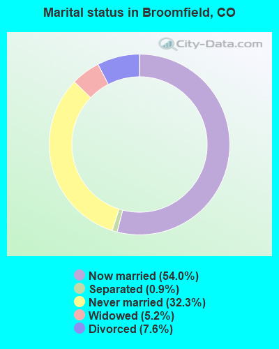
- Never married: 32.3%
- Now married: 54.0%
- Separated: 0.9%
- Widowed: 5.2%
- Divorced: 7.6%
For population 25 years and over in Broomfield:
- High school or higher: 94.2%
- Bachelor's degree or higher: 57.8%
- Graduate or professional degree: 24.6%
- Unemployed: 2.2%
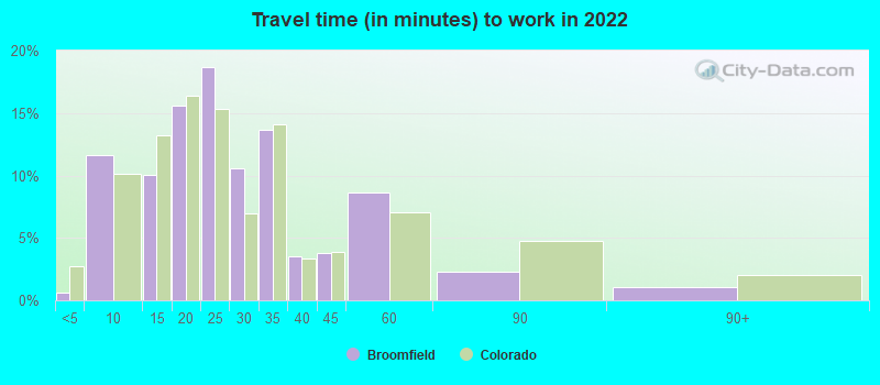
- Mean travel time to work (commute): 17.7 minutes

| Here: | 9.9 |
| Colorado average: | 11.1 |
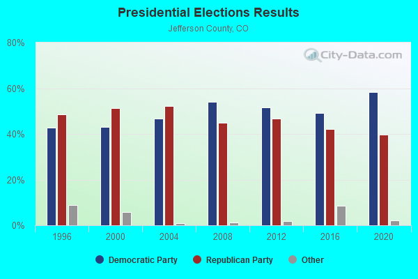

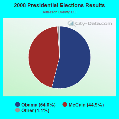
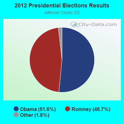
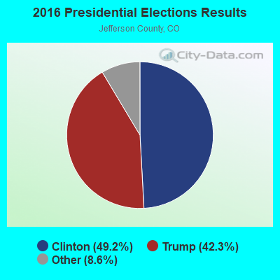

Graphs represent county-level data. Detailed 2008 Election Results
Neighborhoods in Broomfield:
(Broomfield, Colorado Neighborhood Map)- Alred neighborhood
- Anderson neighborhood
- Andresen neighborhood
- Anthem neighborhood
- Appaloosa Acres neighborhood
- Aspen Creek neighborhood
- Aspen North neighborhood
- Atlas Industrial Park neighborhood
- Ball Aerospace neighborhood
- Barker Estates neighborhood
- Barnett Estates neighborhood
- Becker neighborhood
- Blair neighborhood
- Blue Ribbon neighborhood
- Bradburn neighborhood
- Brainard neighborhood
- Brandywine neighborhood
- Broadlands neighborhood
- Broomfield Business Center neighborhood
- Broomfield City Center neighborhood
- Broomfield Commercial neighborhood
- Broomfield Corporate Center neighborhood
- Broomfield Country Club neighborhood
- Broomfield County Commons neighborhood
- Broomfield Gardens neighborhood
- Broomfield Heights neighborhood
- Broomfield Highlands neighborhood
- Broomfield Industrial Park neighborhood
- Broomfield North neighborhood
- Broomfield Plaza neighborhood
- Broomfield Professional Park neighborhood
- Broomfield Retail Center neighborhood
- Broomfield Technological Park neighborhood
- Broomfield Town Centre neighborhood
- Broomfield Urban Transit Village neighborhood
- Brozovich neighborhood
- Carriage House West neighborhood
- Cedar Acres neighborhood
- Chateaux At Fox Meadows neighborhood
- Chavez neighborhood
- Cheyenne Ridge neighborhood
- Cimarron (Continental) neighborhood
- Cloverleaf neighborhood
- Collier Industrial Park neighborhood
- Colman's Lakeview neighborhood
- Columbine Meadows neighborhood
- Corbin Manor neighborhood
- Cottonwood Creek neighborhood
- Country neighborhood
- Country Meadow neighborhood
- Country Vista neighborhood
- Crofton Park neighborhood
- Crystal Pines neighborhood
- Depot Hill neighborhood
- Diamond Shamrock neighborhood
- Donelson neighborhood
- East Broomfield neighborhood
- Ehmens Acres neighborhood
- Elliot neighborhood
- Emerald Hill neighborhood
- Fairwind neighborhood
- Fiore neighborhood
- Flatiron Marketplace neighborhood
- Foster Industrial Park neighborhood
- Foxborough neighborhood
- Front Range neighborhood
- Gate N Green neighborhood
- Great Western Park neighborhood
- Green Acre Estates neighborhood
- Green Family Farm neighborhood
- Greenway Park neighborhood
- Hazlewood neighborhood
- Hero Acres neighborhood
- High Ridge neighborhood
- Highland Park South neighborhood
- Hotchkiss Goss neighborhood
- Hunter Douglas Business Park neighborhood
- Huntington Trails neighborhood
- Hyland Greens neighborhood
- Ideal Industrial Park neighborhood
- Imagine Acres neighborhood
- Indigo Creek neighborhood
- Interlocken neighborhood
- Interpark neighborhood
- Irvin Industries neighborhood
- James Acres neighborhood
- Jeffco Office Park neighborhood
- Juda neighborhood
- Judy neighborhood
- La Placa neighborhood
- Lac Amora neighborhood
- Lambertson Farms neighborhood
- Larkridge neighborhood
- Lawrence's Place neighborhood
- Lexington neighborhood
- Lincoln Southpoint neighborhood
- Lone Pasture neighborhood
- Lorimer neighborhood
- Main Street Exchange neighborhood
- Marini neighborhood
- Mark neighborhood
- Martin neighborhood
- Mauler neighborhood
- Mckay Landing neighborhood
- Midcities neighborhood
- Midway Plaza neighborhood
- Miramonte neighborhood
- Monarch neighborhood
- Moormeier neighborhood
- Morton neighborhood
- Mountain View neighborhood
- Mustang Acres neighborhood
- Myle Stone Estates neighborhood
- Norberg neighborhood
- North Star Estates neighborhood
- Northmoor neighborhood
- Northridge neighborhood
- Northwest Estates neighborhood
- Norwest neighborhood
- Olson neighborhood
- Original Broomfield neighborhood
- Park Business Plaza neighborhood
- Park Plaza Commons neighborhood
- Park Plaza Midway neighborhood
- Parkway Circle neighborhood
- Pinnacle North neighborhood
- Pony Estates neighborhood
- Preble Creek neighborhood
- Purslow neighborhood
- Quail Hill neighborhood
- Rangeview Tech Center neighborhood
- Red Hawk neighborhood
- Red Leaf neighborhood
- Ridge View neighborhood
- Ridgeview Heights neighborhood
- Robin Hill Farm neighborhood
- Rodney Schultz neighborhood
- Roy-Jo neighborhood
- Saddlewood neighborhood
- Schultz neighborhood
- Sessions Acres neighborhood
- Shaklee neighborhood
- Shannon Acres neighborhood
- Silver Eagle Acres neighborhood
- Silver Oaks neighborhood
- Southern Slope neighborhood
- Spruce Meadows neighborhood
- Such Acres neighborhood
- Sunnyslope neighborhood
- Sunridge Two neighborhood
- Swain neighborhood
- The Falls At Legend Trails neighborhood
- The Orchard at Westminster neighborhood
- The Outlook neighborhood
- The Overlook District neighborhood
- The Ridge At Broomfield neighborhood
- Tiara neighborhood
- Trails At Westlake neighborhood
- Turnpike Industrial Park neighborhood
- Valley Vista Estates neighborhood
- Village Acres neighborhood
- Westbrooke Preserve neighborhood
- Westlake Village neighborhood
- Whistlepig neighborhood
- Wilcox neighborhood
- Wildgrass neighborhood
- Willow Park neighborhood
- Willow Run neighborhood
- Wright Acres neighborhood
- Zuni neighborhood
Religion statistics for Broomfield, CO (based on Jefferson County data)
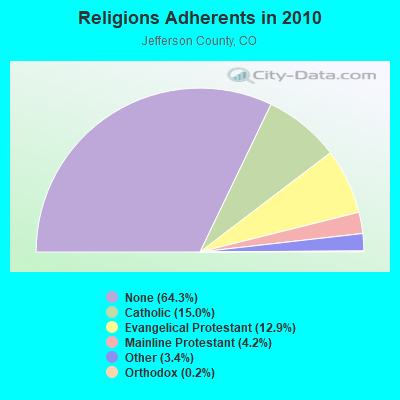
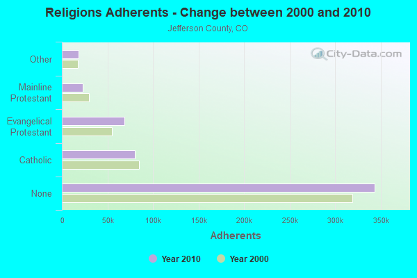
| Religion | Adherents | Congregations |
|---|---|---|
| Catholic | 80,219 | 17 |
| Evangelical Protestant | 68,794 | 196 |
| Mainline Protestant | 22,716 | 57 |
| Other | 17,966 | 62 |
| Orthodox | 1,070 | 3 |
| None | 343,778 | - |
Food Environment Statistics:
| This county: | 1.10 / 10,000 pop. |
| State: | 1.50 / 10,000 pop. |
| This county: | 0.09 / 10,000 pop. |
| Colorado: | 0.15 / 10,000 pop. |
| Jefferson County: | 0.34 / 10,000 pop. |
| Colorado: | 0.45 / 10,000 pop. |
| Here: | 2.75 / 10,000 pop. |
| Colorado: | 3.13 / 10,000 pop. |
| This county: | 7.76 / 10,000 pop. |
| State: | 8.99 / 10,000 pop. |
| Jefferson County: | 5.3% |
| State: | 5.3% |
| Jefferson County: | 17.4% |
| Colorado: | 18.4% |
| Jefferson County: | 9.6% |
| Colorado: | 9.6% |
Health and Nutrition:
| This city: | 51.2% |
| Colorado: | 49.4% |
| This city: | 50.1% |
| Colorado: | 47.8% |
| Broomfield: | 28.2 |
| State: | 28.5 |
| Broomfield: | 20.3% |
| State: | 20.7% |
| Broomfield: | 8.9% |
| Colorado: | 9.7% |
| Broomfield: | 6.8 |
| Colorado: | 6.8 |
| Broomfield: | 32.3% |
| Colorado: | 33.3% |
| Broomfield: | 59.4% |
| Colorado: | 57.3% |
| This city: | 81.5% |
| Colorado: | 80.2% |
More about Health and Nutrition of Broomfield, CO Residents
Broomfield government finances - Expenditure in 2021 (per resident):
- Construction - Parks and Recreation: $1,739,000 ($22.85)
Regular Highways: $161,000 ($2.12)
Housing and Community Development: $5,000 ($0.07)
- Current Operations - Police Protection: $30,522,000 ($400.97)
Central Staff Services: $28,160,000 ($369.94)
Water Utilities: $20,585,000 ($270.42)
General - Other: $18,484,000 ($242.82)
Parks and Recreation: $14,327,000 ($188.21)
Public Welfare - Other: $12,833,000 ($168.59)
Sewerage: $9,179,000 ($120.58)
Regular Highways: $8,537,000 ($112.15)
Housing and Community Development: $6,792,000 ($89.23)
General Public Buildings: $4,485,000 ($58.92)
Health - Other: $4,134,000 ($54.31)
Libraries: $3,093,000 ($40.63)
Miscellaneous Commercial Activities - Other: $222,000 ($2.92)
Parking Facilities: $32,000 ($0.42)
- General - Interest on Debt: $9,984,000 ($131.16)
- Other Capital Outlay - General - Other: $49,232,000 ($646.76)
Parks and Recreation: $610,000 ($8.01)
Regular Highways: $142,000 ($1.87)
Broomfield government finances - Revenue in 2021 (per resident):
- Charges - Other: $17,490,000 ($229.77)
Sewerage: $10,116,000 ($132.89)
Miscellaneous Commercial Activities: $260,000 ($3.42)
- Miscellaneous - Interest Earnings: $10,745,000 ($141.16)
General Revenue - Other: $1,136,000 ($14.92)
Special Assessments: $1,058,000 ($13.90)
Fines and Forfeits: $601,000 ($7.90)
Sale of Property: $177,000 ($2.33)
Donations From Private Sources: $96,000 ($1.26)
- Revenue - Water Utilities: $18,983,000 ($249.38)
- State Intergovernmental - Public Welfare: $9,534,000 ($125.25)
Other: $4,949,000 ($65.01)
Highways: $3,169,000 ($41.63)
General Local Government Support: $114,000 ($1.50)
- Tax - General Sales and Gross Receipts: $86,043,000 ($1130.35)
Property: $40,598,000 ($533.34)
Other: $6,948,000 ($91.28)
Other License: $3,766,000 ($49.47)
Other Selective Sales: $802,000 ($10.54)
Broomfield government finances - Cash and Securities in 2021 (per resident):
- Bond Funds - Cash and Securities: $110,543,000 ($1452.20)
- Other Funds - Cash and Securities: $236,038,000 ($3100.83)
- Sinking Funds - Cash and Securities: $34,700,000 ($455.85)
11.22% of this county's 2021 resident taxpayers lived in other counties in 2020 ($78,273 average adjusted gross income)
| Here: | 11.22% |
| Colorado average: | 11.28% |
0.01% of residents moved from foreign countries ($77 average AGI)
Jefferson County: 0.01% Colorado average: 0.05%
Top counties from which taxpayers relocated into this county between 2020 and 2021:
| from Denver County, CO | |
| from Adams County, CO | |
| from Arapahoe County, CO |
11.40% of this county's 2020 resident taxpayers moved to other counties in 2021 ($73,305 average adjusted gross income)
| Here: | 11.40% |
| Colorado average: | 11.05% |
0.01% of residents moved to foreign countries ($82 average AGI)
Jefferson County: 0.01% Colorado average: 0.03%
Top counties to which taxpayers relocated from this county between 2020 and 2021:
| to Denver County, CO | |
| to Adams County, CO | |
| to Arapahoe County, CO |
| Businesses in Broomfield, CO | ||||
| Name | Count | Name | Count | |
|---|---|---|---|---|
| 24 Hour Fitness | 1 | JoS. A. Bank | 1 | |
| 7-Eleven | 1 | Jones New York | 4 | |
| ALDO | 1 | Journeys | 1 | |
| AT&T | 7 | Justice | 1 | |
| Abercrombie & Fitch | 1 | KFC | 1 | |
| Abercrombie Kids | 1 | Kmart | 1 | |
| Advance Auto Parts | 2 | Kroger | 3 | |
| Aeropostale | 1 | Lane Bryant | 1 | |
| American Eagle Outfitters | 1 | Lane Furniture | 1 | |
| Ann Taylor | 1 | LensCrafters | 1 | |
| Apple Store | 1 | Macy's | 1 | |
| Applebee's | 2 | Marriott | 1 | |
| Arby's | 1 | MasterBrand Cabinets | 6 | |
| Banana Republic | 1 | Mazda | 1 | |
| Bath & Body Works | 1 | McDonald's | 4 | |
| Bebe | 1 | Men's Wearhouse | 1 | |
| Big O Tires | 2 | Motherhood Maternity | 2 | |
| Blockbuster | 1 | New Balance | 4 | |
| Brookstone | 1 | New York & Co | 1 | |
| Burger King | 1 | Nike | 11 | |
| Cache | 1 | Nordstrom | 2 | |
| Charlotte Russe | 1 | Old Navy | 1 | |
| Chevrolet | 1 | Pac Sun | 1 | |
| Chico's | 1 | Panda Express | 1 | |
| Circle K | 3 | Papa John's Pizza | 1 | |
| Clarks | 1 | Payless | 1 | |
| Coldwater Creek | 1 | PetSmart | 1 | |
| Crate & Barrel | 1 | Pier 1 Imports | 1 | |
| Cricket Wireless | 1 | Pizza Hut | 1 | |
| Curves | 2 | Pottery Barn | 1 | |
| Dairy Queen | 2 | Pottery Barn Kids | 1 | |
| Decora Cabinetry | 2 | Qdoba Mexican Grill | 2 | |
| Discount Tire | 1 | RadioShack | 2 | |
| Domino's Pizza | 1 | Red Robin | 1 | |
| Eddie Bauer | 1 | SONIC Drive-In | 2 | |
| Express | 2 | Safeway | 2 | |
| FedEx | 9 | Sears | 2 | |
| Finish Line | 1 | Sephora | 1 | |
| Firestone Complete Auto Care | 1 | Spencer Gifts | 1 | |
| Foot Locker | 1 | Sprint Nextel | 2 | |
| Ford | 1 | Starbucks | 7 | |
| Forever 21 | 1 | Subway | 8 | |
| GNC | 2 | T-Mobile | 4 | |
| GameStop | 2 | Taco Bell | 2 | |
| Gap | 1 | Talbots | 1 | |
| Gymboree | 1 | Target | 1 | |
| H&R Block | 1 | U-Haul | 3 | |
| Haagen-Dazs | 1 | UPS | 15 | |
| Hobby Lobby | 1 | Vans | 3 | |
| Hollister Co. | 1 | Victoria's Secret | 1 | |
| Home Depot | 2 | Village Inn | 1 | |
| Hot Topic | 1 | Vons | 2 | |
| Hyatt | 1 | Walgreens | 3 | |
| J. Jill | 1 | Walmart | 2 | |
| J.Crew | 1 | Wendy's | 1 | |
| Jack In The Box | 2 | Wet Seal | 1 | |
| Jimmy John's | 2 | |||
Strongest AM radio stations in Broomfield:
- KKZN (760 AM; 50 kW; THORNTON, CO; Owner: JACOR BROADCASTING OF COLORADO, INC.)
- KLTT (670 AM; 50 kW; COMMERCE CITY, CO; Owner: KLZ RADIO, INC.)
- KPOF (910 AM; 5 kW; DENVER, CO; Owner: PILLAR OF FIRE)
- KLZ (560 AM; 5 kW; DENVER, CO; Owner: KLZ RADIO, INC.)
- KHOW (630 AM; 5 kW; DENVER, CO; Owner: CITICASTERS LICENSES, L.P.)
- KRKS (990 AM; 10 kW; DENVER, CO; Owner: SALEM MEDIA OF COLORADO, INC.)
- KLMO (1060 AM; 30 kW; LONGMONT, CO; Owner: PILGRIM COMMUNICATIONS, INC.)
- KKFN (950 AM; 5 kW; DENVER, CO; Owner: JEFFERSON-PILOT COMMUNICATIONS COMPANY OF COLORADO)
- KVCU (1190 AM; 7 kW; BOULDER, CO; Owner: THE UNIVERSITY OF CO FOUNDATION, INC.)
- KBJD (1650 AM; 10 kW; DENVER, CO; Owner: SALEM MEDIA OF COLORADO, INC.)
- KMXA (1090 AM; 50 kW; AURORA, CO; Owner: ENTRAVISION HOLDINGS, LLC)
- KOA (850 AM; 50 kW; DENVER, CO; Owner: JACOR BROADCASTING OF COLORADO, INC.)
- KNUS (710 AM; 5 kW; DENVER, CO; Owner: SALEM MEDIA OF COLORADO, INC.)
Strongest FM radio stations in Broomfield:
- KBCO-FM (97.3 FM; BOULDER, CO; Owner: CITICASTERS LICENSES, L.P.)
- KJCD (104.3 FM; LONGMONT, CO; Owner: JEFFERSON-PILOT COMMUNICATIONS COMPANY OF COLORADO)
- KALC (105.9 FM; DENVER, CO; Owner: ENTERCOM DENVER LICENSE, LLC)
- KBPI (106.7 FM; DENVER, CO; Owner: JACOR BROADCASTING OF COLORADO, INC.)
- KQMT (99.5 FM; DENVER, CO; Owner: ENTERCOM DENVER LICENSE, LLC)
- KFMD (95.7 FM; DENVER, CO; Owner: CITICASTERS LICENSES, L.P.)
- KOSI (101.1 FM; DENVER, CO; Owner: ENTERCOM DENVER LICENSE, LLC)
- KRFX (103.5 FM; DENVER, CO; Owner: JACOR BROADCASTING OF COLORADO, INC.)
- KRKS-FM (94.7 FM; LAFAYETTE, CO; Owner: SALEM MEDIA OF COLORADO, INC)
- KDJM (92.5 FM; BROOMFIELD, CO; Owner: INFINITY RADIO OPERATIONS INC.)
- KTCL (93.3 FM; FORT COLLINS, CO; Owner: JACOR BROADCASTING OF COLORADO, INC.)
- KQKS (107.5 FM; LAKEWOOD, CO; Owner: JEFFERSON-PILOT COMMUNICATIONS COMPANY OF COLORADO)
- KUVO (89.3 FM; DENVER, CO; Owner: DENVER EDUCATIONAL BROADCASTING)
- KIMN (100.3 FM; DENVER, CO; Owner: INFINITY RADIO OPERATIONS INC.)
- KVOD (90.1 FM; DENVER, CO; Owner: PUBLIC BROADCASTING OF COLORADO, INC)
- KYGO-FM (98.5 FM; DENVER, CO; Owner: JEFFERSON-PILOT COMMUNICATIONS COMPANY OF COLORADO)
- KXPK (96.5 FM; EVERGREEN, CO; Owner: ENTRAVISION HOLDINGS, LLC)
- K209DE (89.7 FM; GOLDEN, CO; Owner: WAY-FM MEDIA GROUP, INC.)
- KGNU (88.5 FM; BOULDER, CO; Owner: BOULDER COMMUNITY B/CST. ASSN., INC.)
- KXKL-FM (105.1 FM; DENVER, CO; Owner: INFINITY RADIO OPERATIONS INC.)
TV broadcast stations around Broomfield:
- KMGH-TV (Channel 7; DENVER, CO; Owner: MCGRAW-HILL BROADCASTING COMPANY, INC.)
- KDEN (Channel 25; LONGMONT, CO; Owner: LONGMONT CHANNEL 25, INC.)
- KUSA-TV (Channel 9; DENVER, CO; Owner: MULTIMEDIA HOLDINGS CORPORATION)
- KRMA-TV (Channel 6; DENVER, CO; Owner: ROCKY MOUNTAIN PUBLIC BROADCASTING NETWORK, INC.)
- KTVD (Channel 20; DENVER, CO; Owner: TWENVER BROADCAST, INC.)
- KCNC-TV (Channel 4; DENVER, CO; Owner: CBS TELEVISION STATIONS INC.)
- K48FW (Channel 48; DENVER, CO; Owner: TRINITY BROADCASTING NETWORK)
- KWGN-TV (Channel 2; DENVER, CO; Owner: KWGN INC.)
- K66FB (Channel 66; DENVER, CO; Owner: TRINITY BROADCASTING NETWORK)
- K47IH (Channel 47; BOULDER, CO; Owner: CHANNEL 20 TV COMPANY)
- KDEO-LP (Channel 38; AURORA, CO; Owner: PETER B. VAN DE SANDE)
- KDVR (Channel 31; DENVER, CO; Owner: FOX TELEVISION STATIONS, INC.)
- KMAS-LP (Channel 63; DENVER, CO; Owner: TELEMUNDO OF STEAMBOAT SPRINGS COLO. LIC. CORP.)
- K44CT (Channel 44; BOULDER, CO; Owner: ROCKY MOUNTAIN PUBLIC BROADCASTING NETWORK, INC.)
- KPXC-TV (Channel 59; DENVER, CO; Owner: PAXSON DENVER LICENSE, INC.)
- KDEV-LP (Channel 62; AURORA, CO; Owner: TIGER EYE BROADCASTING CORPORATION)
- KDVT-LP (Channel 36; DENVER, CO; Owner: ENTRAVISION HOLDINGS, LLC)
- K17CF (Channel 17; BOULDER, CO; Owner: FULL GOSPEL OUTREACH, INC.)
Broomfield fatal accident list:
Mar 20, 2001 10:30 PM, Us-36, Vehicles: 2, Persons: 3, Fatalities: 2, Drunk persons involved: 1
Oct 28, 1993 11:53 PM, 121, Vehicles: 3, Persons: 3, Pedestrians: 2, Fatalities: 1
Feb 4, 1988 09:34 PM, Pierce St, Vehicles: 2, Persons: 3, Fatalities: 1
- National Bridge Inventory (NBI) Statistics
- 74Number of bridges
- 915ft / 279mTotal length
- $2,686,000Total costs
- 1,519,433Total average daily traffic
- 99,962Total average daily truck traffic
- New bridges - historical statistics
- 11960-1969
- 41970-1979
- 71980-1989
- 131990-1999
- 432000-2009
- 62010-2019
FCC Registered Antenna Towers: 184 (See the full list of FCC Registered Antenna Towers)
FCC Registered Private Land Mobile Towers: 2 (See the full list of FCC Registered Private Land Mobile Towers in Broomfield, CO)
FCC Registered Broadcast Land Mobile Towers: 42 (See the full list of FCC Registered Broadcast Land Mobile Towers)
FCC Registered Microwave Towers: 74 (See the full list of FCC Registered Microwave Towers in this town)
FCC Registered Paging Towers: 2 (See the full list of FCC Registered Paging Towers)
FCC Registered Maritime Coast & Aviation Ground Towers: 13 (See the full list of FCC Registered Maritime Coast & Aviation Ground Towers)
FCC Registered Amateur Radio Licenses: 600 (See the full list of FCC Registered Amateur Radio Licenses in Broomfield)
FAA Registered Aircraft Manufacturers and Dealers: 28 (See the full list of FAA Registered Manufacturers and Dealers in Broomfield)
FAA Registered Aircraft: 175 (See the full list of FAA Registered Aircraft)
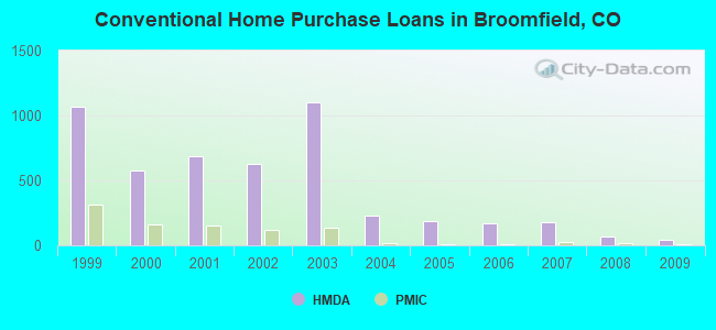
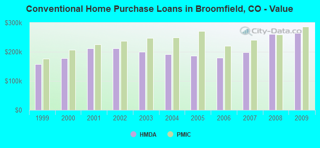
| Home Mortgage Disclosure Act Aggregated Statistics For Year 2009 (Based on 8 partial tracts) | ||||||||||
| A) FHA, FSA/RHS & VA Home Purchase Loans | B) Conventional Home Purchase Loans | C) Refinancings | D) Home Improvement Loans | F) Non-occupant Loans on < 5 Family Dwellings (A B C & D) | ||||||
|---|---|---|---|---|---|---|---|---|---|---|
| Number | Average Value | Number | Average Value | Number | Average Value | Number | Average Value | Number | Average Value | |
| LOANS ORIGINATED | 37 | $244,611 | 43 | $264,994 | 257 | $237,064 | 8 | $79,041 | 5 | $227,830 |
| APPLICATIONS APPROVED, NOT ACCEPTED | 2 | $271,555 | 4 | $232,368 | 20 | $227,647 | 2 | $158,235 | 0 | $0 |
| APPLICATIONS DENIED | 2 | $148,280 | 5 | $293,030 | 56 | $232,932 | 7 | $99,001 | 4 | $157,202 |
| APPLICATIONS WITHDRAWN | 4 | $243,765 | 4 | $342,710 | 42 | $243,278 | 3 | $151,540 | 1 | $168,140 |
| FILES CLOSED FOR INCOMPLETENESS | 0 | $0 | 2 | $272,540 | 16 | $241,058 | 0 | $0 | 1 | $144,200 |
Detailed mortgage data for all 14 tracts in Broomfield, CO
| Private Mortgage Insurance Companies Aggregated Statistics For Year 2009 (Based on 6 partial tracts) | ||||
| A) Conventional Home Purchase Loans | B) Refinancings | |||
|---|---|---|---|---|
| Number | Average Value | Number | Average Value | |
| LOANS ORIGINATED | 10 | $285,624 | 11 | $263,313 |
| APPLICATIONS APPROVED, NOT ACCEPTED | 2 | $168,495 | 3 | $274,763 |
| APPLICATIONS DENIED | 1 | $338,000 | 2 | $292,545 |
| APPLICATIONS WITHDRAWN | 0 | $0 | 1 | $304,610 |
| FILES CLOSED FOR INCOMPLETENESS | 0 | $0 | 1 | $229,940 |
2003 - 2018 National Fire Incident Reporting System (NFIRS) incidents
- Fire incident types reported to NFIRS in Broomfield, CO
- 70339.1%Structure Fires
- 68337.9%Outside Fires
- 33418.6%Mobile Property/Vehicle Fires
- 804.4%Other
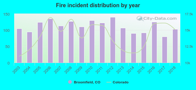 Based on the data from the years 2003 - 2018 the average number of fire incidents per year is 112. The highest number of fires - 140 took place in 2012, and the least - 80 in 2017. The data has a dropping trend.
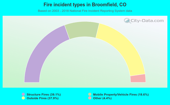 When looking into fire subcategories, the most incidents belonged to: Structure Fires (39.1%), and Outside Fires (37.9%).
Fire-safe hotels and motels in Broomfield, Colorado:
- Aloft Broomfield/Denver - Broomfield Lodging, LLC, 8300 Arista Pl, Broomfield, Colorado 80021 , Phone: (303) 635-2000, Fax: (303) 464-1615
- Hyatt House Boulder/Broomfield, 13351 W Midway Blvd, Broomfield, Colorado 80020 , Phone: (720) 890-4811
- Holiday Inn Express Denver Northwest - Broomfield, 11401 Via Varra, Broomfield, Colorado 80020 , Phone: (303) 926-8777, Fax: (303) 926-8778
- Fairfield Inn & Suites Broomfield, 455 Zang St, Broomfield, Colorado 80021 , Phone: (303) 466-7020
- Residence Inn Broomfield, 455 Zang St, Broomfield, Colorado 80021 , Phone: (303) 466-7007
| Most common first names in Broomfield, CO among deceased individuals | ||
| Name | Count | Lived (average) |
|---|---|---|
| Robert | 109 | 72.0 years |
| William | 107 | 72.2 years |
| John | 103 | 73.8 years |
| Mary | 92 | 78.7 years |
| James | 86 | 69.3 years |
| Charles | 64 | 73.1 years |
| Ruth | 56 | 79.9 years |
| Richard | 55 | 65.8 years |
| Dorothy | 53 | 77.9 years |
| Donald | 51 | 72.1 years |
| Most common last names in Broomfield, CO among deceased individuals | ||
| Last name | Count | Lived (average) |
|---|---|---|
| Smith | 44 | 76.3 years |
| Johnson | 38 | 77.1 years |
| Miller | 23 | 76.4 years |
| Williams | 23 | 69.0 years |
| Peterson | 19 | 80.9 years |
| Anderson | 18 | 77.6 years |
| Davis | 18 | 76.6 years |
| Brown | 17 | 67.2 years |
| Thompson | 17 | 73.9 years |
| Jones | 16 | 77.8 years |
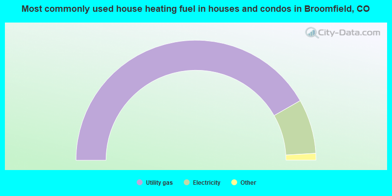
- 83.4%Utility gas
- 14.7%Electricity
- 0.9%Bottled, tank, or LP gas
- 0.4%Solar energy
- 0.4%Wood
- 0.2%No fuel used
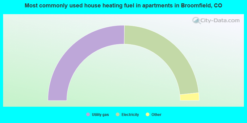
- 50.4%Utility gas
- 46.3%Electricity
- 2.0%Bottled, tank, or LP gas
- 1.0%No fuel used
- 0.3%Other fuel
Broomfield compared to Colorado state average:
- Unemployed percentage significantly below state average.
- Foreign-born population percentage above state average.
- House age below state average.
- Percentage of population with a bachelor's degree or higher above state average.
Broomfield on our top lists:
- #9 on the list of "Top 101 cities with the lowest number of burglaries per 100,000 residents (population 50,000+)"
- #11 on the list of "Top 100 highest located cities (pop. 50,000+)"
- #13 on the list of "Top 101 cities with the smallest city-data.com crime index per police officer (population 50,000+)"
- #20 on the list of "Top 101 cities with the lowest number of robberies per 100,000 residents (population 50,000+)"
- #21 on the list of "Top 101 cities with largest percentage of males in industries: information (population 50,000+)"
- #21 on the list of "Top 101 cities with largest percentage of males in industries: management of companies and enterprises (population 50,000+)"
- #25 on the list of "Top 101 cities with the lowest number of assaults per 100,000 residents (population 50,000+)"
- #28 on the list of "Top 101 cities with the smallest sunshine amount differences during a year (population 50,000+)"
- #35 on the list of "Top 101 cities with the lowest city-data.com crime index (population 50,000+)"
- #38 on the list of "Top 101 cities with the lowest maximum monthly morning or afternoon humidity (population 50,000+)"
- #40 on the list of "Top 100 safest cities (lowest city-data.com crime index) (pop. 50,000+)"
- #47 on the list of "Top 101 cities with largest percentage of females in occupations: computer and mathematical occupations (population 50,000+)"
- #48 on the list of "Top 101 cities with largest percentage of males in occupations: architecture and engineering occupations (population 50,000+)"
- #48 on the list of "Top 101 cities with largest percentage of females in occupations: architecture and engineering occupations (population 50,000+)"
- #48 on the list of "Top 101 cities with the largest differences between daily high and daily low temperatures (population 50,000+)"
- #54 on the list of "Top 101 cities with largest percentage of females in industries: information (population 50,000+)"
- #55 on the list of "Top 101 cities with largest percentage of males in occupations: computer and mathematical occupations (population 50,000+)"
- #56 on the list of "Top 101 cities with the lowest average humidity (population 50,000+)"
- #64 on the list of "Top 101 cities with largest percentage of females in occupations: legal occupations (population 50,000+)"
- #64 on the list of "Top 101 cities with the largest percentage population increase from 2000 (population 50,000+)"
- #12 on the list of "Top 101 counties with the highest percentage of residents that exercised in the past month"
- #19 on the list of "Top 101 counties with the largest increase in the number of deaths per 1000 residents 2000-2006 to 2007-2013 (pop. 50,000+)"
- #22 on the list of "Top 101 counties with the best general health status score of residents (1-5), 3 years of data"
- #45 on the list of "Top 101 counties with the lowest average weight of females"
- #55 on the list of "Top 101 counties with the highest surface withdrawal of fresh water for public supply (pop. 50,000+)"

|
|
Total of 2226 patent applications in 2008-2024.