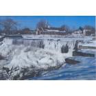
Burrillville, Rhode Island
Submit your own pictures of this town and show them to the world
- OSM Map
- Google Map
- MSN Map
Population change since 2000: +1.0%
 |
| Males: 7,933 | |
| Females: 8,022 |
| Median resident age: | 42.4 years |
| Rhode Island median age: | 42.3 years |
Zip codes: 02830.
| Burrillville: | $107,157 |
| RI: | $81,854 |
Estimated per capita income in 2022: $43,315 (it was $21,096 in 2000)
Burrillville town income, earnings, and wages data
Estimated median house or condo value in 2022: $396,335 (it was $134,200 in 2000)
| Burrillville: | $396,335 |
| RI: | $383,900 |
Mean prices in 2022: all housing units: $374,091; detached houses: $391,079; townhouses or other attached units: $339,877; in 2-unit structures: $329,737; in 3-to-4-unit structures: $340,395; in 5-or-more-unit structures: $281,172; mobile homes: $172,414
Detailed information about poverty and poor residents in Burrillville, RI


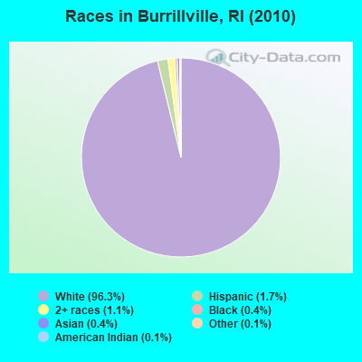
- 15,35996.3%White alone
- 2651.7%Hispanic
- 1741.1%Two or more races
- 620.4%Black alone
- 580.4%Asian alone
- 170.1%American Indian alone
- 190.1%Other race alone
- 10.01%Native Hawaiian and Other
Pacific Islander alone
Races in Burrillville detailed stats: ancestries, foreign born residents, place of birth
According to our research of Rhode Island and other state lists, there was 1 registered sex offender living in Burrillville, Rhode Island as of April 27, 2024.
The ratio of all residents to sex offenders in Burrillville is 15,955 to 1.
The ratio of registered sex offenders to all residents in this city is much lower than the state average.
Type |
2009 |
2010 |
2011 |
2012 |
2013 |
2014 |
2015 |
2016 |
2017 |
2018 |
2019 |
2020 |
2021 |
2022 |
|---|---|---|---|---|---|---|---|---|---|---|---|---|---|---|
| Murders (per 100,000) | 0 (0.0) | 0 (0.0) | 0 (0.0) | 0 (0.0) | 0 (0.0) | 0 (0.0) | 1 (6.1) | 0 (0.0) | 0 (0.0) | 0 (0.0) | 1 (5.9) | 0 (0.0) | 0 (0.0) | 0 (0.0) |
| Rapes (per 100,000) | 3 (18.1) | 1 (6.3) | 2 (12.6) | 2 (12.5) | 7 (43.4) | 2 (12.3) | 10 (61.3) | 9 (55.0) | 4 (24.3) | 7 (41.7) | 2 (11.9) | 2 (11.8) | 8 (45.7) | 7 (43.1) |
| Robberies (per 100,000) | 0 (0.0) | 1 (6.3) | 0 (0.0) | 2 (12.5) | 0 (0.0) | 0 (0.0) | 0 (0.0) | 0 (0.0) | 1 (6.1) | 0 (0.0) | 0 (0.0) | 2 (11.8) | 0 (0.0) | 0 (0.0) |
| Assaults (per 100,000) | 13 (78.4) | 7 (43.9) | 8 (50.2) | 4 (25.1) | 13 (80.5) | 10 (61.7) | 6 (36.8) | 6 (36.7) | 11 (66.9) | 13 (77.5) | 6 (35.6) | 11 (65.1) | 7 (40.0) | 3 (18.5) |
| Burglaries (per 100,000) | 45 (271.2) | 55 (344.7) | 36 (225.9) | 71 (445.4) | 33 (204.4) | 22 (135.8) | 19 (116.4) | 22 (134.5) | 18 (109.5) | 22 (131.1) | 17 (100.8) | 6 (35.5) | 8 (45.7) | 12 (73.9) |
| Thefts (per 100,000) | 100 (602.8) | 120 (752.1) | 125 (784.4) | 146 (915.9) | 103 (638.1) | 105 (648.2) | 96 (588.3) | 82 (501.3) | 73 (444.0) | 72 (429.1) | 57 (338.1) | 54 (319.5) | 39 (222.8) | 41 (252.4) |
| Auto thefts (per 100,000) | 6 (36.2) | 10 (62.7) | 18 (113.0) | 14 (87.8) | 7 (43.4) | 8 (49.4) | 7 (42.9) | 6 (36.7) | 2 (12.2) | 3 (17.9) | 5 (29.7) | 5 (29.6) | 5 (28.6) | 2 (12.3) |
| Arson (per 100,000) | 1 (6.0) | 2 (12.5) | 3 (18.8) | 1 (6.3) | 4 (24.8) | 2 (12.3) | 0 (0.0) | 1 (6.1) | 4 (24.3) | 3 (17.9) | 2 (11.9) | 2 (11.8) | 2 (11.4) | 0 (0.0) |
| City-Data.com crime index | 76.1 | 74.9 | 76.3 | 93.7 | 94.1 | 61.6 | 103.8 | 83.8 | 61.1 | 76.6 | 51.4 | 43.7 | 59.0 | 54.4 |
The City-Data.com crime index weighs serious crimes and violent crimes more heavily. Higher means more crime, U.S. average is 246.1. It adjusts for the number of visitors and daily workers commuting into cities.
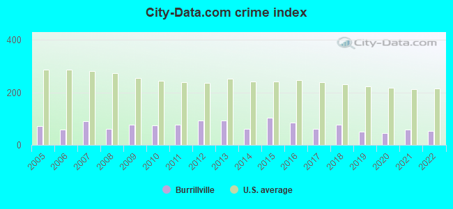
Crime rate in Burrillville detailed stats: murders, rapes, robberies, assaults, burglaries, thefts, arson
Full-time law enforcement employees in 2021, including police officers: 32 (25 officers - 21 male; 4 female).
| Officers per 1,000 residents here: | 1.43 |
| Rhode Island average: | 2.27 |
 Recent articles from our blog. Our writers, many of them Ph.D. graduates or candidates, create easy-to-read articles on a wide variety of topics.
Ancestries: French (29.0%), Irish (18.6%), French Canadian (18.1%), English (15.4%), Italian (13.1%), Polish (6.3%).
Current Local Time: EST time zone
Incorporated in 1806
Land area: 55.6 square miles.
Population density: 287 people per square mile (very low).
269 residents are foreign born
| This town: | 1.7% |
| Rhode Island: | 11.4% |
| Burrillville town: | 1.8% ($2,370) |
| Rhode Island: | 1.9% ($2,507) |
Nearest city with pop. 50,000+: Providence, RI  (16.8 miles , pop. 173,618).
Nearest city with pop. 200,000+: Boston, MA (39.0 miles , pop. 589,141).
Nearest city with pop. 1,000,000+: Bronx, NY (137.6 miles , pop. 1,332,650).
Nearest cities:
), ), ), )Latitude: 41.97 N, Longitude: 71.68 W
Area code commonly used in this area: 401
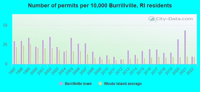
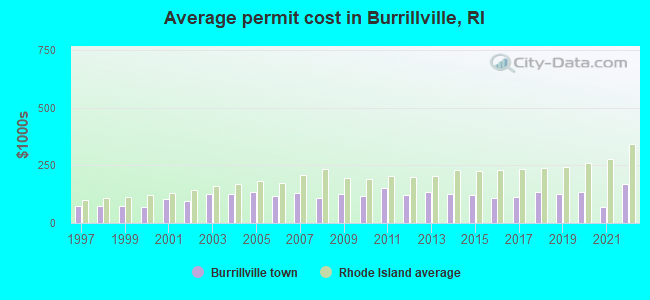
Single-family new house construction building permits:
- 2022: 16 buildings, average cost: $169,600
- 2021: 69 buildings, average cost: $71,000
- 2020: 51 buildings, average cost: $133,700
- 2019: 24 buildings, average cost: $124,400
- 2018: 23 buildings, average cost: $133,000
- 2017: 30 buildings, average cost: $115,300
- 2016: 31 buildings, average cost: $109,100
- 2015: 27 buildings, average cost: $121,300
- 2014: 19 buildings, average cost: $128,400
- 2013: 28 buildings, average cost: $136,200
- 2012: 10 buildings, average cost: $122,400
- 2011: 15 buildings, average cost: $150,700
- 2010: 18 buildings, average cost: $119,300
- 2009: 15 buildings, average cost: $124,300
- 2008: 26 buildings, average cost: $107,000
- 2007: 43 buildings, average cost: $130,400
- 2006: 42 buildings, average cost: $117,000
- 2005: 54 buildings, average cost: $136,000
- 2004: 26 buildings, average cost: $127,400
- 2003: 35 buildings, average cost: $127,500
- 2002: 56 buildings, average cost: $93,800
- 2001: 49 buildings, average cost: $103,400
- 2000: 36 buildings, average cost: $71,300
- 1999: 54 buildings, average cost: $76,300
- 1998: 48 buildings, average cost: $75,200
- 1997: 47 buildings, average cost: $75,500
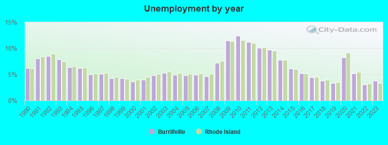
| Here: | 3.8% |
| Rhode Island: | 3.3% |
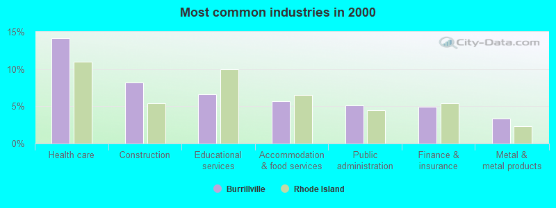
- Health care (14.2%)
- Construction (8.2%)
- Educational services (6.6%)
- Accommodation & food services (5.7%)
- Public administration (5.1%)
- Finance & insurance (4.9%)
- Metal & metal products (3.4%)
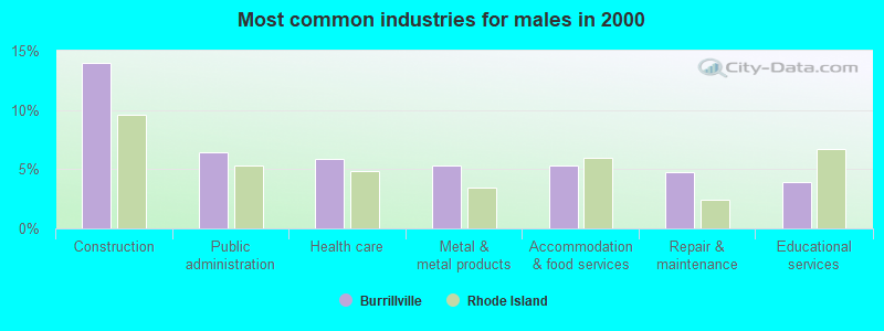
- Construction (14.0%)
- Public administration (6.4%)
- Health care (5.9%)
- Metal & metal products (5.3%)
- Accommodation & food services (5.3%)
- Repair & maintenance (4.8%)
- Educational services (3.9%)
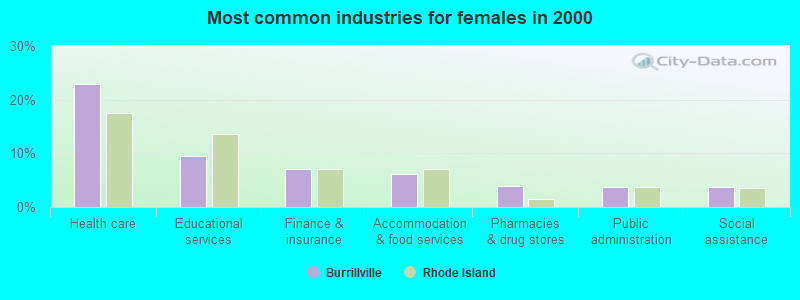
- Health care (22.9%)
- Educational services (9.5%)
- Finance & insurance (7.0%)
- Accommodation & food services (6.1%)
- Pharmacies & drug stores (3.9%)
- Public administration (3.8%)
- Social assistance (3.6%)
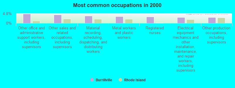
- Other office and administrative support workers, including supervisors (4.7%)
- Other sales and related occupations, including supervisors (4.3%)
- Material recording, scheduling, dispatching, and distributing workers (3.6%)
- Metal workers and plastic workers (3.4%)
- Registered nurses (3.1%)
- Electrical equipment mechanics and other installation, maintenance, and repair workers, including supervisors (2.9%)
- Other production occupations, including supervisors (2.9%)
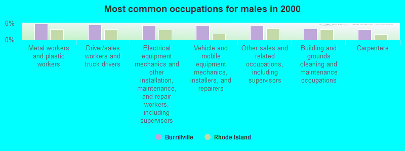
- Metal workers and plastic workers (5.8%)
- Driver/sales workers and truck drivers (5.4%)
- Electrical equipment mechanics and other installation, maintenance, and repair workers, including supervisors (5.3%)
- Vehicle and mobile equipment mechanics, installers, and repairers (5.3%)
- Other sales and related occupations, including supervisors (5.2%)
- Building and grounds cleaning and maintenance occupations (4.1%)
- Carpenters (3.8%)
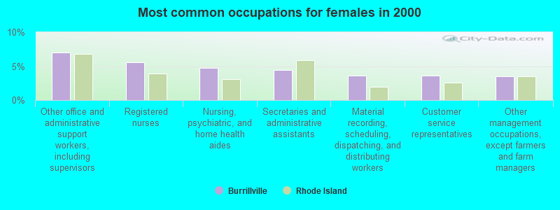
- Other office and administrative support workers, including supervisors (7.1%)
- Registered nurses (5.5%)
- Nursing, psychiatric, and home health aides (4.8%)
- Secretaries and administrative assistants (4.4%)
- Material recording, scheduling, dispatching, and distributing workers (3.6%)
- Customer service representatives (3.6%)
- Other management occupations, except farmers and farm managers (3.5%)
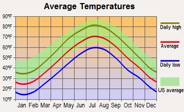
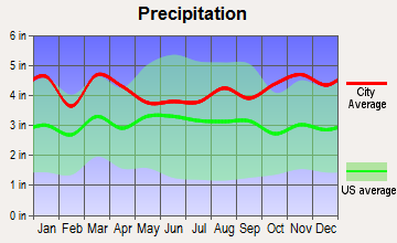
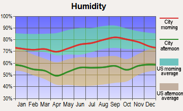
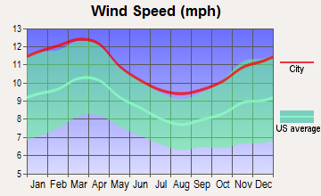
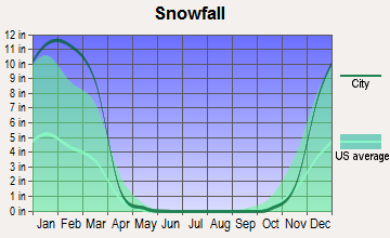
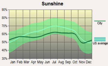
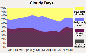
Average climate in Burrillville, Rhode Island
Based on data reported by over 4,000 weather stations
(lower is better)
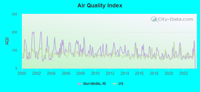
Air Quality Index (AQI) level in 2023 was 87.3. This is worse than average.
| City: | 87.3 |
| U.S.: | 72.6 |
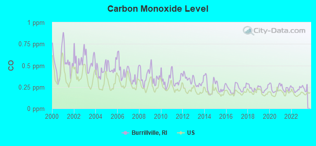
Carbon Monoxide (CO) [ppm] level in 2022 was 0.224. This is about average. Closest monitor was 16.5 miles away from the city center.
| City: | 0.224 |
| U.S.: | 0.251 |
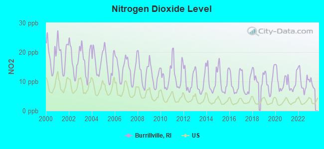
Nitrogen Dioxide (NO2) [ppb] level in 2022 was 10.1. This is significantly worse than average. Closest monitor was 1.0 miles away from the city center.
| City: | 10.1 |
| U.S.: | 5.1 |
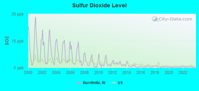
Sulfur Dioxide (SO2) [ppb] level in 2022 was 0.263. This is significantly better than average. Closest monitor was 1.0 miles away from the city center.
| City: | 0.263 |
| U.S.: | 1.515 |
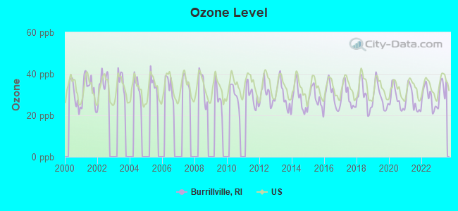
Ozone [ppb] level in 2023 was 32.3. This is about average. Closest monitor was 9.7 miles away from the city center.
| City: | 32.3 |
| U.S.: | 33.3 |
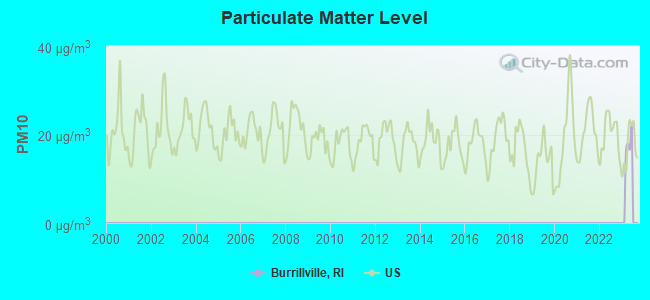
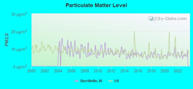
Particulate Matter (PM2.5) [µg/m3] level in 2022 was 6.24. This is better than average. Closest monitor was 3.9 miles away from the city center.
| City: | 6.24 |
| U.S.: | 8.11 |
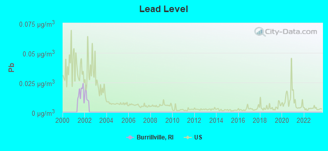
Lead (Pb) [µg/m3] level in 2001 was 0.0160. This is significantly worse than average. Closest monitor was 12.2 miles away from the city center.
| City: | 0.0160 |
| U.S.: | 0.0093 |
Tornado activity:
Burrillville-area historical tornado activity is slightly above Rhode Island state average. It is 33% smaller than the overall U.S. average.
On 6/9/1953, a category F4 (max. wind speeds 207-260 mph) tornado 24.4 miles away from the Burrillville town center killed 90 people and injured 1228 people and caused between $50,000,000 and $500,000,000 in damages.
On 6/9/1953, a category F3 (max. wind speeds 158-206 mph) tornado 14.6 miles away from the town center injured 17 people and caused between $500,000 and $5,000,000 in damages.
Earthquake activity:
Burrillville-area historical earthquake activity is significantly above Rhode Island state average. It is 72% smaller than the overall U.S. average.On 10/7/1983 at 10:18:46, a magnitude 5.3 (5.1 MB, 5.3 LG, 5.1 ML, Class: Moderate, Intensity: VI - VII) earthquake occurred 192.2 miles away from the city center
On 4/20/2002 at 10:50:47, a magnitude 5.3 (5.3 ML, Depth: 3.0 mi) earthquake occurred 203.1 miles away from Burrillville center
On 4/20/2002 at 10:50:47, a magnitude 5.2 (5.2 MB, 4.2 MS, 5.2 MW, 5.0 MW) earthquake occurred 202.1 miles away from the city center
On 1/19/1982 at 00:14:42, a magnitude 4.7 (4.5 MB, 4.7 MD, 4.5 LG, Class: Light, Intensity: IV - V) earthquake occurred 106.0 miles away from the city center
On 10/16/2012 at 23:12:25, a magnitude 4.7 (4.7 ML, Depth: 10.0 mi) earthquake occurred 124.1 miles away from Burrillville center
On 8/22/1992 at 12:20:32, a magnitude 4.8 (4.8 MB, 3.8 MS, 4.7 LG, Depth: 6.2 mi) earthquake occurred 210.6 miles away from the city center
Magnitude types: regional Lg-wave magnitude (LG), body-wave magnitude (MB), duration magnitude (MD), local magnitude (ML), surface-wave magnitude (MS), moment magnitude (MW)
Natural disasters:
The number of natural disasters in Providence County (17) is near the US average (15).Major Disasters (Presidential) Declared: 7
Emergencies Declared: 10
Causes of natural disasters: Hurricanes: 5, Snowstorms: 4, Blizzards: 3, Floods: 2, Storms: 2, Winter Storms: 2, Snow: 1, Snowfall: 1, Tropical Storm: 1, Water Main Break: 1, Wind: 1, Other: 1 (Note: some incidents may be assigned to more than one category).
Hospitals and medical centers near Burrillville:
- NICOLE MANOR (Nursing Home, about 2 miles away; PASCOAG, RI)
- OVERLOOK NURSING AND REHABILITATION CENTER (Nursing Home, about 2 miles away; PASCOAG, RI)
- BAYBERRY COMMONS (Nursing Home, about 3 miles away; PASCOAG, RI)
- PINE GROVE HEALTH CENTER (Nursing Home, about 3 miles away; PASCOAG, RI)
- EAST WALLUM LAKE GROUP HOME (Hospital, about 4 miles away; PASCOAG, RI)
- LYDIA TAFT HOUSE (Nursing Home, about 8 miles away; UXBRIDGE, MA)
- BLACKSTONE NURSING HOME (Nursing Home, about 8 miles away; BLACKSTONE, MA)
Amtrak station near Burrillville:
Colleges/universities with over 2000 students nearest to Burrillville:
- Bryant University (about 9 miles; Smithfield, RI; Full-time enrollment: 3,440)
- Rhode Island College (about 15 miles; Providence, RI; FT enrollment: 7,189)
- Providence College (about 16 miles; Providence, RI; FT enrollment: 4,312)
- Johnson & Wales University-Providence (about 18 miles; Providence, RI; FT enrollment: 10,898)
- Rhode Island School of Design (about 18 miles; Providence, RI; FT enrollment: 2,714)
- Brown University (about 18 miles; Providence, RI; FT enrollment: 8,458)
- College of the Holy Cross (about 20 miles; Worcester, MA; FT enrollment: 3,125)
Points of interest:
Notable locations in Burrillville: Round Top Fishing Area (A), Oak Valley (B), The Shrine (C), Pascoag Public Library (D), Burrillville Town Hall (E), Pascoag Fire Department Station (F), Wallum Lake Fire Department (G), Pascoag Fire Department (H), Oakland - Mapleville Fire Department Station 1 (I), Nasonville Fire Department (J), Jesse M Smith Memorial Library (K), Harrisville Fire Department (L), Burrillville Police Department (M). Display/hide their locations on the map
Churches in Burrillville include: First Universalist Church of Burrillville (A), Burrillville United Methodist Church (B), Berean Baptist Church (C), Calvary Episcopal Church (D), Pascoag Community Baptist Church (E), New Hope Baptist Church (F). Display/hide their locations on the map
Cemetery: Abigal Cemetery (1). Display/hide its location on the map
Lakes, reservoirs, and swamps: Duck Pond (A), Spring Lake (B), Wilbur Pond (C), Cedar Swamp Pond (D), Round Pond (E), Lapham Pond (F), Little Round Top Pond (G), Peck Pond (H). Display/hide their locations on the map
Streams, rivers, and creeks: Goat Rock Brook (A), Clear River (B), Leeson Brook (C), Cold Spring Brook (D), Tarkiln Brook (E), Tucker Brook (F), Dry Arm Brook (G), Iron Mine Brook (H), Leland Brook (I). Display/hide their locations on the map
Parks in Burrillville include: Buck Hill State Management Area (1), Casimir Pulaski Memorial State Park (2), Black Hut State Management Area (3), Harrisville Historic District (4). Display/hide their locations on the map
Beaches: YWCA Beach (A), Gillerans Pond Beach (B), Spring Lake Beach (C), Flynns Beach (D). Display/hide their locations on the map
Drinking water stations with addresses in Burrillville and their reported violations in the past:
MONTYS VICTORY DINER (Population served: 90, Groundwater):Past health violations:WALLUM LAKE ROD & GUN CLUB, INC. (Population served: 25, Groundwater):Past monitoring violations:
- MCL, Monthly (TCR) - Between JAN-2009 and MAR-2009, Contaminant: Coliform. Follow-up actions: St Violation/Reminder Notice (JAN-30-2009), St Boil Water Order (JAN-30-2009), St Public Notif requested (JAN-30-2009), St Formal NOV issued (JAN-30-2009), St Compliance achieved (JUL-29-2009)
- One routine major monitoring violation
Past monitoring violations:
- One routine major monitoring violation
- 2 regular monitoring violations
| This town: | 2.6 people |
| Rhode Island: | 2.4 people |
| This town: | 73.9% |
| Whole state: | 62.8% |
| This town: | 7.7% |
| Whole state: | 7.6% |
Likely homosexual households (counted as self-reported same-sex unmarried-partner households)
- Lesbian couples: 0.4% of all households
- Gay men: 0.4% of all households
| This town: | 6.1% |
| Whole state: | 11.9% |
| This town: | 3.2% |
| Whole state: | 5.4% |
People in group quarters in Burrillville in 2010:
- 366 people in nursing facilities/skilled-nursing facilities
- 38 people in group homes intended for adults
- 31 people in group homes for juveniles (non-correctional)
- 27 people in other noninstitutional facilities
- 5 people in residential treatment centers for juveniles (non-correctional)
- 3 people in emergency and transitional shelters (with sleeping facilities) for people experiencing homelessness
People in group quarters in Burrillville in 2000:
- 281 people in nursing homes
- 152 people in hospitals/wards and hospices for chronically ill
- 152 people in other hospitals or wards for chronically ill
- 29 people in religious group quarters
- 17 people in homes or halfway houses for drug/alcohol abuse
- 8 people in homes for the mentally ill
- 6 people in homes for the mentally retarded
For population 15 years and over in Burrillville:
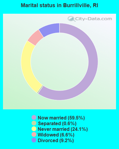
- Never married: 24.1%
- Now married: 59.5%
- Separated: 0.6%
- Widowed: 6.6%
- Divorced: 9.2%
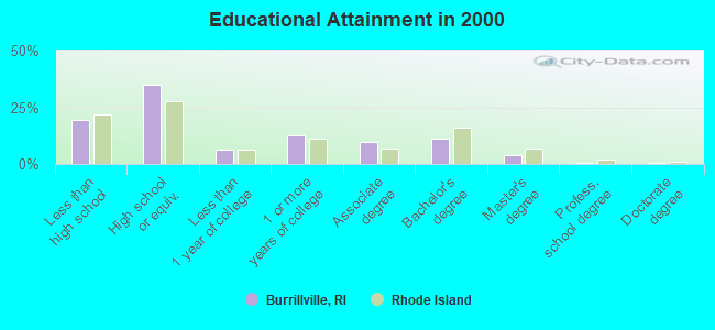
For population 25 years and over in Burrillville:
- High school or higher: 80.4%
- Bachelor's degree or higher: 16.2%
- Graduate or professional degree: 5.0%
- Unemployed: 4.9%
- Mean travel time to work (commute): 29.8 minutes
| Here: | 10.4 |
| Rhode Island average: | 14.0 |
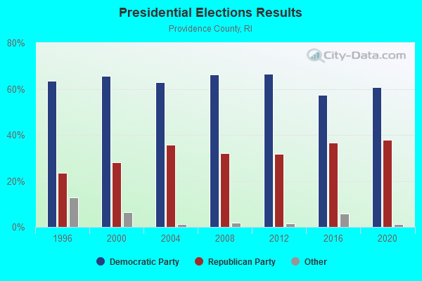
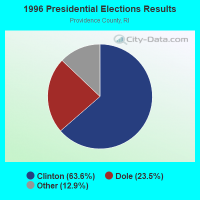
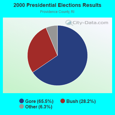
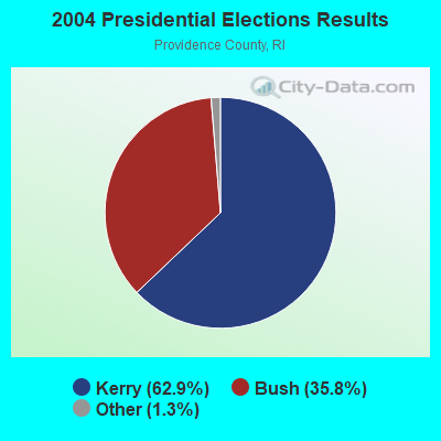
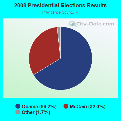
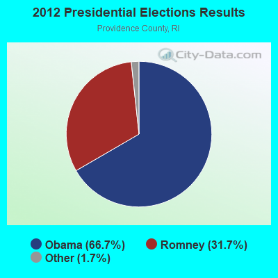
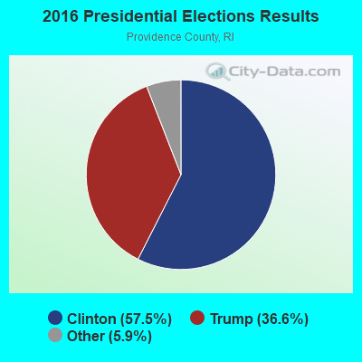
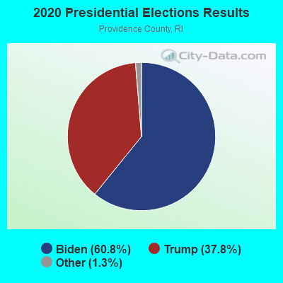
Graphs represent county-level data. Detailed 2008 Election Results
Religion statistics for Burrillville, RI (based on Providence County data)
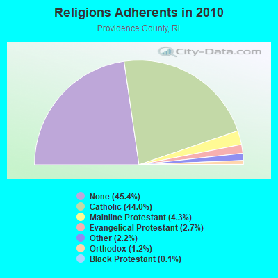
| Religion | Adherents | Congregations |
|---|---|---|
| Catholic | 276,011 | 98 |
| Mainline Protestant | 27,143 | 111 |
| Evangelical Protestant | 16,895 | 134 |
| Other | 13,896 | 48 |
| Orthodox | 7,325 | 10 |
| Black Protestant | 712 | 9 |
| None | 284,685 | - |
Food Environment Statistics:
| Providence County: | 2.06 / 10,000 pop. |
| Rhode Island: | 1.92 / 10,000 pop. |
| This county: | 0.02 / 10,000 pop. |
| State: | 0.05 / 10,000 pop. |
| Providence County: | 1.50 / 10,000 pop. |
| Rhode Island: | 1.42 / 10,000 pop. |
| Providence County: | 2.10 / 10,000 pop. |
| State: | 2.24 / 10,000 pop. |
| Here: | 7.96 / 10,000 pop. |
| State: | 9.75 / 10,000 pop. |
| This county: | 8.1% |
| Rhode Island: | 7.9% |
| Providence County: | 24.0% |
| Rhode Island: | 22.6% |
| This county: | 16.9% |
| State: | 16.3% |
5.01% of this county's 2021 resident taxpayers lived in other counties in 2020 ($66,379 average adjusted gross income)
| Here: | 5.01% |
| Rhode Island average: | 5.99% |
0.03% of residents moved from foreign countries ($121 average AGI)
Providence County: 0.03% Rhode Island average: 0.03%
Top counties from which taxpayers relocated into this county between 2020 and 2021:
| from Kent County, RI | |
| from Bristol County, MA | |
| from Suffolk County, MA |
5.35% of this county's 2020 resident taxpayers moved to other counties in 2021 ($68,172 average adjusted gross income)
| Here: | 5.35% |
| Rhode Island average: | 5.97% |
0.01% of residents moved to foreign countries ($59 average AGI)
Providence County: 0.01% Rhode Island average: 0.02%
Top counties to which taxpayers relocated from this county between 2020 and 2021:
| to Kent County, RI | |
| to Bristol County, MA | |
| to Washington County, RI |
Businesses in Burrillville, RI
- Dunkin Donuts: 1
Strongest AM radio stations in Burrillville:
- WALE (990 AM; 50 kW; GREENVILLE, RI; Owner: NORTH AMERICAN BROADCASTING CO., INC.)
- WCRN (830 AM; 50 kW; WORCESTER, MA; Owner: CARTER BROADCASTING CORPORATION)
- WKOX (1200 AM; 50 kW; FRAMINGHAM, MA; Owner: CAPSTAR TX LIMITED PARTNERSHIP)
- WEEI (850 AM; 50 kW; BOSTON, MA; Owner: ENTERCOM BOSTON LICENSE, LLC)
- WBIX (1060 AM; 40 kW; NATICK, MA; Owner: LANGER BROADCASTING CORPORATION)
- WAMG (890 AM; 25 kW; DEDHAM, MA; Owner: MEGA COMMUNICATIONS OF DEDHAM LICENSEE, LLC)
- WVNE (760 AM; daytime; 25 kW; LEICESTER, MA; Owner: BLOUNT MASSCOM, INC.)
- WRKO (680 AM; 50 kW; BOSTON, MA; Owner: ENTERCOM BOSTON LICENSE, LLC)
- WRNI (1290 AM; 10 kW; PROVIDENCE, RI; Owner: WRNI FOUNDATION)
- WDDZ (550 AM; 5 kW; PAWTUCKET, RI; Owner: ABC, INC.)
- WINY (1350 AM; 5 kW; PUTNAM, CT; Owner: OSBREY BROADCASTING COMPANY)
- WWZN (1510 AM; 50 kW; BOSTON, MA; Owner: ROSE CITY RADIO CORPORATION)
- WNNZ (640 AM; 50 kW; WESTFIELD, MA; Owner: CLEAR CHANNEL BROADCASTING LICENSES, INC.)
Strongest FM radio stations in Burrillville:
- WWKX (106.3 FM; WOONSOCKET, RI; Owner: AAA ENTERTAINMENT LICENSING LLC)
- WWBB (101.5 FM; PROVIDENCE, RI; Owner: CLEAR CHANNEL BROADCASTING LICENSES, INC.)
- WAAF (107.3 FM; WORCESTER, MA; Owner: ENTERCOM BOSTON LICENSE, LLC)
- WPRO-FM (92.3 FM; PROVIDENCE, RI; Owner: CITADEL BROADCASTING COMPANY)
- WWLI (105.1 FM; PROVIDENCE, RI; Owner: CITADEL BROADCASTING COMPANY)
- WWFX (100.1 FM; SOUTHBRIDGE, MA; Owner: CITADEL BROADCASTING COMPANY)
- WBMX (98.5 FM; BOSTON, MA; Owner: INFINITY RADIO OPERATIONS INC.)
- WSRS (96.1 FM; WORCESTER, MA; Owner: CAPSTAR TX LIMITED PARTNERSHIP)
- WJMN (94.5 FM; BOSTON, MA; Owner: AMFM RADIO LICENSES, L.L.C.)
- WBOS (92.9 FM; BROOKLINE, MA; Owner: GREATER BOSTON RADIO, INC.)
- WCRB (102.5 FM; WALTHAM, MA; Owner: CHARLES RIVER BROADCASTING WCRB LICE)
- WTKK (96.9 FM; BOSTON, MA; Owner: GREATER BOSTON RADIO, INC.)
- WROR-FM (105.7 FM; FRAMINGHAM, MA; Owner: GREATER BOSTON RADIO, INC.)
- WSNE-FM (93.3 FM; TAUNTON, MA; Owner: CAPSTAR TX LIMITED PARTNERSHIP)
- WGBH (89.7 FM; BOSTON, MA; Owner: WGBH EDUCATIONAL FOUNDATION)
- WORC-FM (98.9 FM; WEBSTER, MA; Owner: CITADEL BROADCASTING COMPANY)
- WBRU (95.5 FM; PROVIDENCE, RI; Owner: BROWN BROADCASTING SERVICE, INC.)
- WBUR-FM (90.9 FM; BOSTON, MA; Owner: TRUSTEES OF BOSTON UNIVERSITY)
- WHJY (94.1 FM; PROVIDENCE, RI; Owner: CAPSTAR TX LIMITED PARTNERSHIP)
- WXKS-FM (107.9 FM; MEDFORD, MA; Owner: AMFM RADIO LICENSES, L.L.C.)
TV broadcast stations around Burrillville:
- WPXQ (Channel 69; BLOCK ISLAND, RI; Owner: OCEAN STATE TELEVISION, L.L.C.)
- WUNI (Channel 27; WORCESTER, MA; Owner: ENTRAVISION HOLDINGS, LLC)
- WNAC-TV (Channel 64; PROVIDENCE, RI; Owner: WNAC, LLC)
- WCVB-TV (Channel 5; BOSTON, MA; Owner: WCVB HEARST-ARGYLE TV, INC.)
- WPRI-TV (Channel 12; PROVIDENCE, RI; Owner: TVL BROADCASTING OF RHODE ISLAND, LLC)
- WGBH-TV (Channel 2; BOSTON, MA; Owner: WGBH EDUCATIONAL FOUNDATION)
- WRIW-LP (Channel 50; PROVIDENCE, RI; Owner: ZGS PROVIDENCE, INC.)
- WJAR (Channel 10; PROVIDENCE, RI; Owner: OUTLET BROADCASTING, INC.)
- WLNE-TV (Channel 6; NEW BEDFORD, MA; Owner: FREEDOM BROADCASTING OF SOUTHERN NEW ENGLAND, INC.)
- WUTF (Channel 66; MARLBOROUGH, MA; Owner: TELEFUTURA BOSTON LLC)
- WYDN (Channel 48; WORCESTER, MA; Owner: EDUCATIONAL PUBLIC TV CORPORATION)
- WSBE-TV (Channel 36; PROVIDENCE, RI; Owner: RHODE ISLAND PUBLIC TELECOM. AUTHORITY)
- WMFP (Channel 62; LAWRENCE, MA; Owner: WSAH LICENSE, INC.)
- WHDH-TV (Channel 7; BOSTON, MA; Owner: WHDH-TV)
- WBZ-TV (Channel 4; BOSTON, MA; Owner: VIACOM INC.)
- WGBX-TV (Channel 44; BOSTON, MA; Owner: WGBH EDUCATIONAL FOUNDATION)
- WSBK-TV (Channel 38; BOSTON, MA; Owner: VIACOM INC.)
- WLVI-TV (Channel 56; CAMBRIDGE, MA; Owner: WLVI, INC.)
- WFXT (Channel 25; BOSTON, MA; Owner: FOX TELEVISION STATIONS INC.)
- WWDP (Channel 46; NORWELL, MA; Owner: NORWELL TELEVISION, LLC)
- W40BO (Channel 40; BOSTON, MA; Owner: PAXSON COMMUNICATIONS LPTV, INC.)
- WBPX (Channel 68; BOSTON, MA; Owner: PAXSON BOSTON-68 LICENSE, INC.)
- WHPX (Channel 26; NEW LONDON, CT; Owner: PAXSON HARTFORD LICENSE, INC.)
- WTMU-LP (Channel 32; BOSTON, MA; Owner: ZGS BOSTON, INC.)
- WCRN-LP (Channel 34; LEICESTER, MA; Owner: CARTER BROADCASTING CORPORATION)
- National Bridge Inventory (NBI) Statistics
- 22Number of bridges
- 151ft / 45.8mTotal length
- $28,963,000Total costs
- 112,570Total average daily traffic
- 8,105Total average daily truck traffic
- 125,767Total future (year 2036) average daily traffic
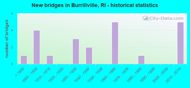
- New bridges - historical statistics
- 1Before 1900
- 41900-1909
- 11910-1919
- 31930-1939
- 21940-1949
- 51960-1969
- 11980-1989
- 52010-2019
FCC Registered Cell Phone Towers:
2 (See the full list of FCC Registered Cell Phone Towers in Burrillville)FCC Registered Antenna Towers:
44 (See the full list of FCC Registered Antenna Towers)FCC Registered Broadcast Land Mobile Towers:
3- Victory Hwy 0.1 Mi From Intersection Rt 7 (Lat: 41.979556 Lon: -71.614500), Call Sign: KLG492, Licensee ID: L00095517,
Assigned Frequencies: 154.190 MHz, Grant Date: 03/03/2022, Expiration Date: 03/16/2032, Registrant: Nasonville Fire Department
- Wallum Lake Rd (Lat: 41.968444 Lon: -71.755611), Call Sign: KBW986,
Assigned Frequencies: 49.0200 MHz, Grant Date: 08/30/2022, Expiration Date: 11/23/2032, Registrant: Keller And Heckman LLP, 1001 G Street Nw, Suite 500, Washington, DC 20001, Phone: (202) 434-4100, Fax: (202) 434-4646, Email:
- Lat: 41.964306 Lon: -71.642722, Call Sign: WRAH901,
Assigned Frequencies: 4940.00 MHz, Grant Date: 11/21/2017, Expiration Date: 11/21/2027, Certifier: Larry Guglietta, Registrant: D & R Communications, 15 Gore Rd, Webster, MA 01570, Phone: (508) 943-9595, Email:
FCC Registered Microwave Towers:
3- BURRILLVILLE POLICE, 1477 Victory Hgwy (Lat: 41.964111 Lon: -71.641667), Type: Mast, Structure height: 51.8 m, Overall height: 53.6 m, Call Sign: WPUY905,
Assigned Frequencies: 10627.5 MHz, Grant Date: 05/01/2012, Expiration Date: 05/30/2022, Cancellation Date: 04/26/2017, Certifier: Carol L Tacker, Registrant: At&t Mobility LLC, 1120 20th Street, Nw - Suite 1000, Washington, DC 20036, Phone: (202) 457-2055, Fax: (202) 457-3073, Email:
- Burrillville, Lat: 41.967417 Lon: -71.754750, Type: Tower, Structure height: 48.8 m, Call Sign: WPXU304,
Assigned Frequencies: 5945.20 MHz, Grant Date: 03/25/2023, Expiration Date: 06/11/2033, Certifier: Scott J Pittman, Registrant: Keller And Heckman LLP, 1001 G Street Nw, Suite 500, Washington, DC 20001, Phone: (202) 434-4100, Fax: (202) 434-4646, Email:
- NEW BURRILLV, 724 Buck Hill Road (Lat: 41.974194 Lon: -71.779944), Type: Mtower, Structure height: 52.1 m, Overall height: 54.6 m, Call Sign: WRXK781, Licensee ID: L00949248,
Assigned Frequencies: 6815.00 MHz, Grant Date: 05/24/2023, Expiration Date: 05/24/2033, Certifier: Chris Mcgrath, Registrant: State Of - Emergency Management Agency Rhode Island, 645 New London Ave, Cranston, RI 02920, Phone: (401) 946-9996, Email:
FCC Registered Amateur Radio Licenses:
2- Call Sign: KI7IWN, Licensee ID: L02065699, Grant Date: 12/02/2016, Expiration Date: 12/02/2026, Certifier: Tanner L Sullivan Thompson, Registrant: Tanner L Sullivan-Thompson, 1090 Douglas Tpke, Burrillville, RI 02830
- Call Sign: KC1HCQ, Licensee ID: L02085912, Grant Date: 03/01/2017, Expiration Date: 03/01/2027, Certifier: Robert C Deckert, Registrant: Robert C Deckert, 1661 Sherman Farm Rd., Burrillville, RI 02830
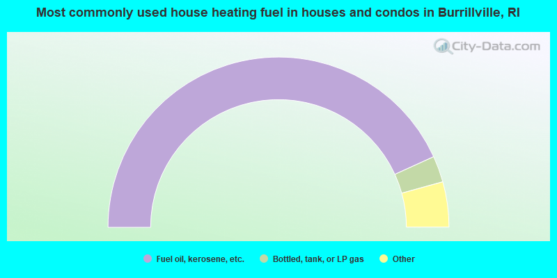
- 86.4%Fuel oil, kerosene, etc.
- 5.0%Bottled, tank, or LP gas
- 3.7%Electricity
- 3.2%Wood
- 1.4%Utility gas
- 0.2%Coal or coke
- 0.2%Other fuel
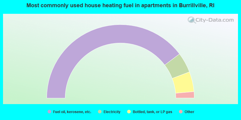
- 79.5%Fuel oil, kerosene, etc.
- 8.9%Electricity
- 8.8%Bottled, tank, or LP gas
- 1.2%Wood
- 1.0%Utility gas
- 0.5%Other fuel
Burrillville compared to Rhode Island state average:
- Unemployed percentage significantly below state average.
- Black race population percentage significantly below state average.
- Hispanic race population percentage significantly below state average.
- Foreign-born population percentage significantly below state average.
- Renting percentage below state average.
- Length of stay since moving in significantly above state average.
- Number of rooms per house significantly below state average.
- House age significantly below state average.
- Institutionalized population percentage above state average.
- Percentage of population with a bachelor's degree or higher below state average.
Burrillville on our top lists:
- #3 on the list of "Top 101 cities with largest percentage of females in industries: pharmacies and drug stores (population 5,000+)"
- #37 on the list of "Top 101 cities with largest percentage of males in occupations: occupational and physical therapist assistants and aides (population 5,000+)"
- #41 on the list of "Top 101 cities with the largest percentage of people in other hospitals or wards for chronically ill (population 1,000+)"
- #42 on the list of "Top 101 cities with largest percentage of males in industries: pharmacies and drug stores (population 5,000+)"
- #49 on the list of "Top 101 cities with the largest percentage of people in hospitals/wards and hospices for chronically ill (population 1,000+)"
- #52 on the list of "Top 101 cities with largest percentage of males in industries: plastics and rubber products (population 5,000+)"
- #55 on the list of "Top 101 cities with largest percentage of females in industries: machinery, equipment, and supplies merchant wholesalers (population 5,000+)"
- #57 on the list of "Top 101 cities with largest percentage of females in industries: health care (population 5,000+)"
- #59 on the list of "Top 101 cities with largest percentage of females in occupations: air transportation workers (population 5,000+)"
- #62 on the list of "Top 101 cities with largest percentage of females in industries: retail florists (population 5,000+)"
- #65 on the list of "Top 101 cities with largest percentage of males in occupations: registered nurses (population 5,000+)"
- #73 on the list of "Top 101 cities with largest percentage of males in industries: warehousing and storage (population 5,000+)"
- #88 on the list of "Top 101 cities with largest percentage of females in industries: printing and related support activities (population 5,000+)"
- #96 on the list of "Top 101 cities with largest percentage of females in occupations: nursing, psychiatric, and home health aides (population 5,000+)"
- #97 on the list of "Top 101 cities with largest percentage of males in industries: retail florists (population 5,000+)"
- #101 on the list of "Top 101 cities with largest percentage of males in industries: fuel dealers (population 5,000+)"
- #34 (02830) on the list of "Top 101 zip codes with the largest percentage of French Canadian first ancestries (pop 5,000+)"
- #17 on the list of "Top 101 counties with highest percentage of residents voting for Obama (Democrat) in the 2012 Presidential Election"
- #18 on the list of "Top 101 counties with the lowest percentage of residents that keep firearms around their homes"
- #20 on the list of "Top 101 counties with the most Catholic congregations"
- #38 on the list of "Top 101 counties with the most Orthodox adherents"
- #46 on the list of "Top 101 counties with the most Catholic adherents"

|
Total of 1 patent application in 2008-2024.