Glocester, Rhode Island
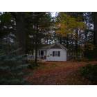
Submit your own pictures of this town and show them to the world
- OSM Map
- Google Map
- MSN Map
Population change since 2000: -2.0%
 |
| Males: 4,926 | |
| Females: 4,820 |
| Median resident age: | 44.7 years |
| Rhode Island median age: | 42.3 years |
Zip codes: 02814.
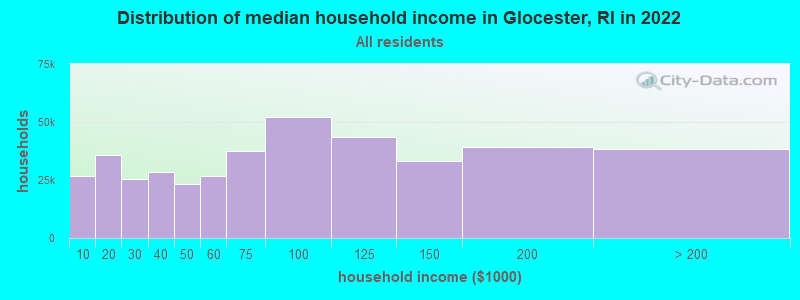
| Glocester: | $117,243 |
| RI: | $81,854 |
Estimated per capita income in 2022: $47,048 (it was $22,914 in 2000)
Glocester town income, earnings, and wages data
Estimated median house or condo value in 2022: $438,568 (it was $148,500 in 2000)
| Glocester: | $438,568 |
| RI: | $383,900 |
Mean prices in 2022: all housing units: $374,091; detached houses: $391,079; townhouses or other attached units: $339,877; in 2-unit structures: $329,737; in 3-to-4-unit structures: $340,395; in 5-or-more-unit structures: $281,172; mobile homes: $172,414
Detailed information about poverty and poor residents in Glocester, RI


- 9,41296.6%White alone
- 1321.4%Hispanic
- 890.9%Two or more races
- 610.6%Asian alone
- 280.3%Black alone
- 140.1%Other race alone
- 90.09%American Indian alone
- 10.01%Native Hawaiian and Other
Pacific Islander alone
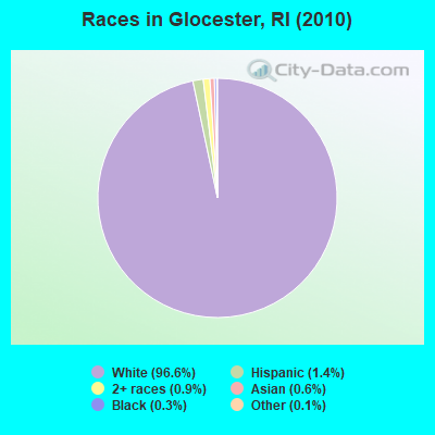
Races in Glocester detailed stats: ancestries, foreign born residents, place of birth
According to our research of Rhode Island and other state lists, there was 1 registered sex offender living in Glocester, Rhode Island as of April 29, 2024.
The ratio of all residents to sex offenders in Glocester is 9,746 to 1.
The ratio of registered sex offenders to all residents in this city is much lower than the state average.
Type |
2009 |
2010 |
2011 |
2012 |
2013 |
2014 |
2015 |
2016 |
2017 |
2018 |
2019 |
2020 |
2021 |
2022 |
|---|---|---|---|---|---|---|---|---|---|---|---|---|---|---|
| Murders (per 100,000) | 0 (0.0) | 0 (0.0) | 0 (0.0) | 0 (0.0) | 0 (0.0) | 0 (0.0) | 0 (0.0) | 0 (0.0) | 0 (0.0) | 0 (0.0) | 0 (0.0) | 0 (0.0) | 0 (0.0) | 0 (0.0) |
| Rapes (per 100,000) | 2 (18.9) | 0 (0.0) | 1 (10.3) | 0 (0.0) | 1 (10.1) | 0 (0.0) | 3 (30.1) | 0 (0.0) | 0 (0.0) | 2 (19.7) | 0 (0.0) | 1 (9.7) | 0 (0.0) | 0 (0.0) |
| Robberies (per 100,000) | 1 (9.4) | 1 (10.3) | 0 (0.0) | 0 (0.0) | 0 (0.0) | 0 (0.0) | 0 (0.0) | 0 (0.0) | 0 (0.0) | 0 (0.0) | 0 (0.0) | 0 (0.0) | 0 (0.0) | 0 (0.0) |
| Assaults (per 100,000) | 1 (9.4) | 6 (61.6) | 2 (20.5) | 6 (61.6) | 2 (20.3) | 4 (40.3) | 1 (10.0) | 1 (10.0) | 3 (29.7) | 3 (29.5) | 4 (38.9) | 7 (67.6) | 5 (46.3) | 4 (39.4) |
| Burglaries (per 100,000) | 11 (103.9) | 13 (133.4) | 13 (133.6) | 12 (123.2) | 19 (192.7) | 19 (191.6) | 10 (100.2) | 9 (89.7) | 6 (59.4) | 6 (59.1) | 5 (48.6) | 7 (67.6) | 4 (37.1) | 1 (9.9) |
| Thefts (per 100,000) | 48 (453.6) | 35 (359.1) | 36 (369.8) | 24 (246.5) | 29 (294.2) | 23 (231.9) | 39 (390.8) | 21 (209.2) | 20 (197.9) | 18 (177.2) | 17 (165.4) | 9 (86.9) | 12 (111.2) | 11 (108.4) |
| Auto thefts (per 100,000) | 1 (9.4) | 4 (41.0) | 5 (51.4) | 6 (61.6) | 1 (10.1) | 2 (20.2) | 0 (0.0) | 2 (19.9) | 7 (69.3) | 6 (59.1) | 4 (38.9) | 3 (29.0) | 0 (0.0) | 8 (78.8) |
| Arson (per 100,000) | 1 (9.4) | 1 (10.3) | 1 (10.3) | 0 (0.0) | 0 (0.0) | 0 (0.0) | 1 (10.0) | 0 (0.0) | 0 (0.0) | 0 (0.0) | 1 (9.7) | 0 (0.0) | 0 (0.0) | 0 (0.0) |
| City-Data.com crime index | 46.0 | 42.4 | 40.6 | 35.7 | 38.2 | 32.4 | 48.7 | 18.2 | 23.5 | 37.6 | 20.9 | 31.8 | 16.3 | 19.2 |
The City-Data.com crime index weighs serious crimes and violent crimes more heavily. Higher means more crime, U.S. average is 246.1. It adjusts for the number of visitors and daily workers commuting into cities.
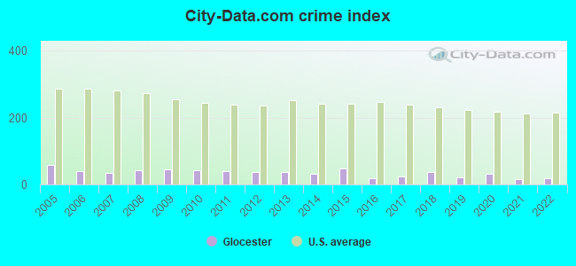
Crime rate in Glocester detailed stats: murders, rapes, robberies, assaults, burglaries, thefts, arson
Full-time law enforcement employees in 2021, including police officers: 22 (16 officers - 16 male; 0 female).
| Officers per 1,000 residents here: | 1.48 |
| Rhode Island average: | 2.27 |
 Recent articles from our blog. Our writers, many of them Ph.D. graduates or candidates, create easy-to-read articles on a wide variety of topics.
Ancestries: English (23.5%), Irish (23.2%), French (19.2%), Italian (17.3%), French Canadian (10.7%), Polish (6.1%).
Current Local Time: EST time zone
Incorporated in 1731
Land area: 54.8 square miles.
Population density: 178 people per square mile (very low).
162 residents are foreign born
| This town: | 1.6% |
| Rhode Island: | 11.4% |
| Glocester town: | 2.0% ($2,977) |
| Rhode Island: | 1.9% ($2,507) |
Nearest city with pop. 50,000+: Providence, RI  (14.6 miles , pop. 173,618).
Nearest city with pop. 200,000+: Boston, MA (42.9 miles , pop. 589,141).
Nearest city with pop. 1,000,000+: Bronx, NY (134.3 miles , pop. 1,332,650).
Nearest cities:
), ), ), )Latitude: 41.89 N, Longitude: 71.69 W
Area code commonly used in this area: 401
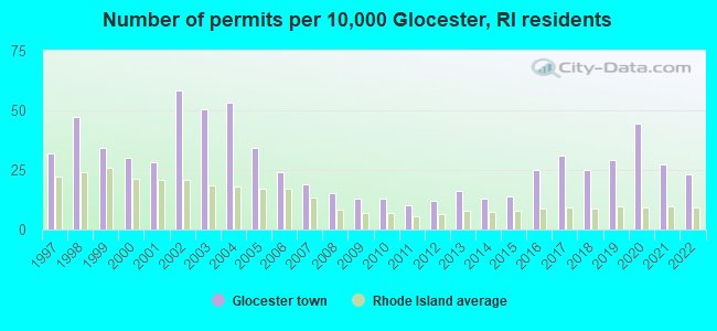
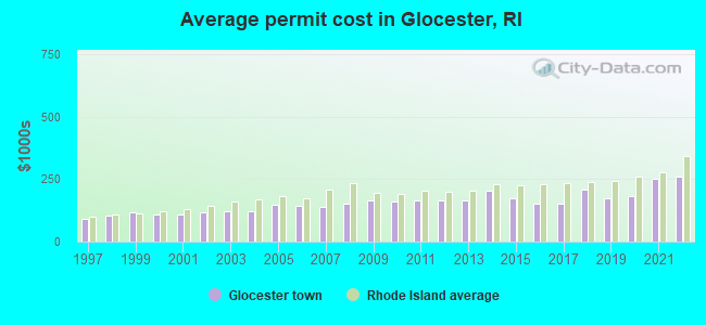
Single-family new house construction building permits:
- 2022: 23 buildings, average cost: $262,600
- 2021: 27 buildings, average cost: $252,800
- 2020: 44 buildings, average cost: $182,900
- 2019: 29 buildings, average cost: $174,700
- 2018: 25 buildings, average cost: $209,400
- 2017: 31 buildings, average cost: $150,400
- 2016: 25 buildings, average cost: $151,300
- 2015: 14 buildings, average cost: $174,900
- 2014: 13 buildings, average cost: $204,100
- 2013: 16 buildings, average cost: $163,500
- 2012: 12 buildings, average cost: $163,500
- 2011: 10 buildings, average cost: $163,600
- 2010: 13 buildings, average cost: $163,100
- 2009: 13 buildings, average cost: $165,400
- 2008: 15 buildings, average cost: $150,700
- 2007: 19 buildings, average cost: $139,500
- 2006: 24 buildings, average cost: $145,100
- 2005: 34 buildings, average cost: $149,200
- 2004: 53 buildings, average cost: $121,500
- 2003: 50 buildings, average cost: $122,500
- 2002: 58 buildings, average cost: $118,500
- 2001: 28 buildings, average cost: $110,200
- 2000: 30 buildings, average cost: $108,200
- 1999: 34 buildings, average cost: $117,400
- 1998: 47 buildings, average cost: $105,400
- 1997: 32 buildings, average cost: $93,300
| Here: | 2.7% |
| Rhode Island: | 3.3% |
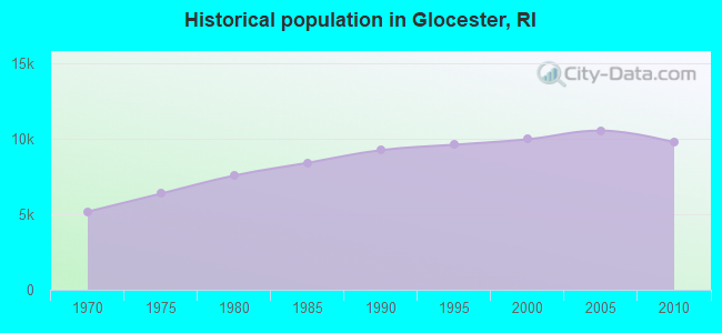
Population change in the 1990s: +734 (+8.0%).
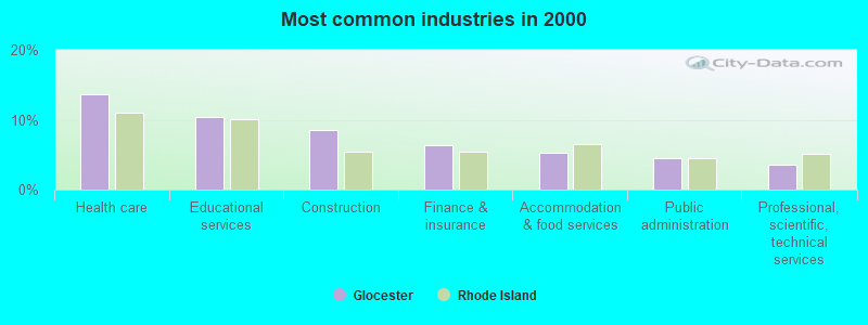
- Health care (13.7%)
- Educational services (10.4%)
- Construction (8.5%)
- Finance & insurance (6.3%)
- Accommodation & food services (5.2%)
- Public administration (4.5%)
- Professional, scientific, technical services (3.6%)
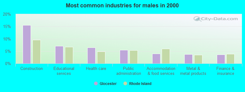
- Construction (15.6%)
- Educational services (7.1%)
- Health care (6.5%)
- Public administration (5.4%)
- Accommodation & food services (3.9%)
- Metal & metal products (3.7%)
- Finance & insurance (3.6%)
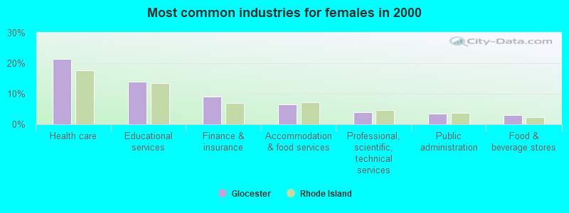
- Health care (21.3%)
- Educational services (14.0%)
- Finance & insurance (9.1%)
- Accommodation & food services (6.6%)
- Professional, scientific, technical services (4.0%)
- Public administration (3.4%)
- Food & beverage stores (3.0%)
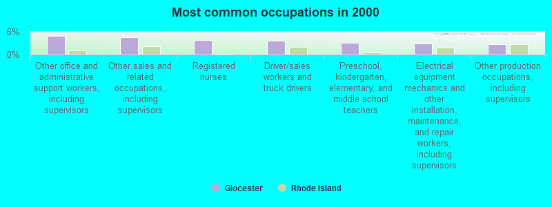
- Other office and administrative support workers, including supervisors (5.0%)
- Other sales and related occupations, including supervisors (4.6%)
- Registered nurses (3.9%)
- Driver/sales workers and truck drivers (3.7%)
- Preschool, kindergarten, elementary, and middle school teachers (3.0%)
- Electrical equipment mechanics and other installation, maintenance, and repair workers, including supervisors (2.8%)
- Other production occupations, including supervisors (2.8%)
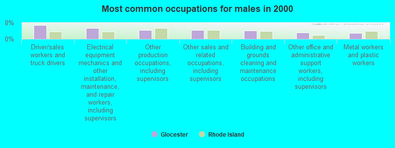
- Driver/sales workers and truck drivers (6.9%)
- Electrical equipment mechanics and other installation, maintenance, and repair workers, including supervisors (5.2%)
- Other production occupations, including supervisors (4.5%)
- Other sales and related occupations, including supervisors (4.5%)
- Building and grounds cleaning and maintenance occupations (4.1%)
- Other office and administrative support workers, including supervisors (3.2%)
- Metal workers and plastic workers (3.0%)
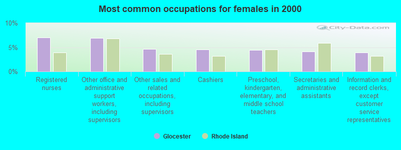
- Registered nurses (7.0%)
- Other office and administrative support workers, including supervisors (6.9%)
- Other sales and related occupations, including supervisors (4.6%)
- Cashiers (4.5%)
- Preschool, kindergarten, elementary, and middle school teachers (4.4%)
- Secretaries and administrative assistants (4.1%)
- Information and record clerks, except customer service representatives (3.9%)
Average climate in Glocester, Rhode Island
Based on data reported by over 4,000 weather stations


(lower is better)
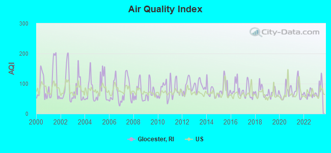
Air Quality Index (AQI) level in 2023 was 84.3. This is about average.
| City: | 84.3 |
| U.S.: | 72.6 |
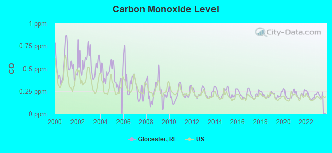
Carbon Monoxide (CO) [ppm] level in 2022 was 0.196. This is better than average. Closest monitor was 14.8 miles away from the city center.
| City: | 0.196 |
| U.S.: | 0.251 |
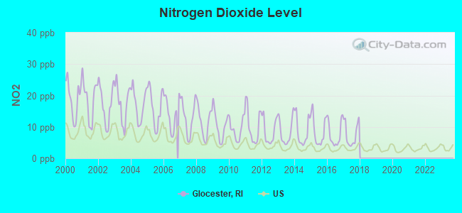
Nitrogen Dioxide (NO2) [ppb] level in 2017 was 7.60. This is significantly worse than average. Closest monitor was 5.5 miles away from the city center.
| City: | 7.60 |
| U.S.: | 5.11 |
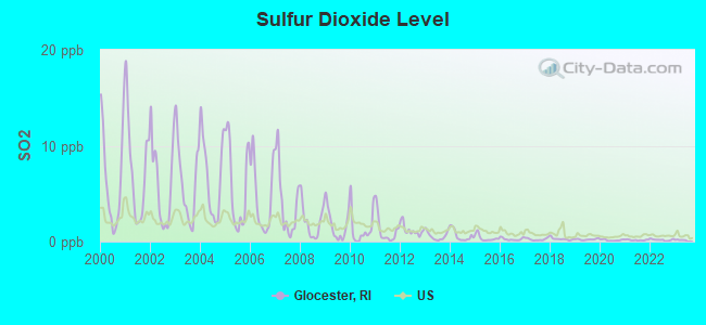
Sulfur Dioxide (SO2) [ppb] level in 2022 was 0.179. This is significantly better than average. Closest monitor was 5.5 miles away from the city center.
| City: | 0.179 |
| U.S.: | 1.515 |
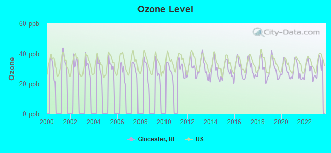
Ozone [ppb] level in 2023 was 33.0. This is about average. Closest monitor was 11.3 miles away from the city center.
| City: | 33.0 |
| U.S.: | 33.3 |
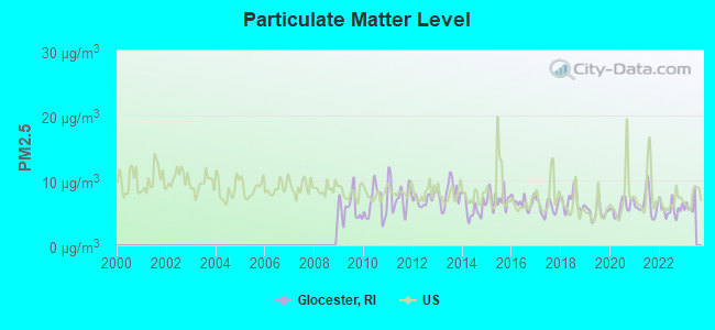
Particulate Matter (PM2.5) [µg/m3] level in 2022 was 5.57. This is significantly better than average. Closest monitor was 1.8 miles away from the city center.
| City: | 5.57 |
| U.S.: | 8.11 |
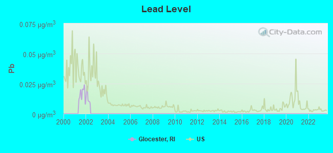
Lead (Pb) [µg/m3] level in 2001 was 0.0161. This is significantly worse than average. Closest monitor was 11.5 miles away from the city center.
| City: | 0.0161 |
| U.S.: | 0.0093 |
Tornado activity:
Glocester-area historical tornado activity is slightly above Rhode Island state average. It is 36% smaller than the overall U.S. average.
On 6/9/1953, a category F4 (max. wind speeds 207-260 mph) tornado 29.6 miles away from the Glocester town center killed 90 people and injured 1228 people and caused between $50,000,000 and $500,000,000 in damages.
On 6/9/1953, a category F3 (max. wind speeds 158-206 mph) tornado 19.7 miles away from the town center injured 17 people and caused between $500,000 and $5,000,000 in damages.
Earthquake activity:
Glocester-area historical earthquake activity is significantly above Rhode Island state average. It is 73% smaller than the overall U.S. average.On 10/7/1983 at 10:18:46, a magnitude 5.3 (5.1 MB, 5.3 LG, 5.1 ML, Class: Moderate, Intensity: VI - VII) earthquake occurred 195.9 miles away from the city center
On 4/20/2002 at 10:50:47, a magnitude 5.3 (5.3 ML, Depth: 3.0 mi) earthquake occurred 207.6 miles away from Glocester center
On 4/20/2002 at 10:50:47, a magnitude 5.2 (5.2 MB, 4.2 MS, 5.2 MW, 5.0 MW) earthquake occurred 206.6 miles away from the city center
On 1/19/1982 at 00:14:42, a magnitude 4.7 (4.5 MB, 4.7 MD, 4.5 LG, Class: Light, Intensity: IV - V) earthquake occurred 111.4 miles away from the city center
On 10/16/2012 at 23:12:25, a magnitude 4.7 (4.7 ML, Depth: 10.0 mi) earthquake occurred 129.2 miles away from Glocester center
On 8/22/1992 at 12:20:32, a magnitude 4.8 (4.8 MB, 3.8 MS, 4.7 LG, Depth: 6.2 mi) earthquake occurred 205.7 miles away from the city center
Magnitude types: regional Lg-wave magnitude (LG), body-wave magnitude (MB), duration magnitude (MD), local magnitude (ML), surface-wave magnitude (MS), moment magnitude (MW)
Natural disasters:
The number of natural disasters in Providence County (17) is near the US average (15).Major Disasters (Presidential) Declared: 7
Emergencies Declared: 10
Causes of natural disasters: Hurricanes: 5, Snowstorms: 4, Blizzards: 3, Floods: 2, Storms: 2, Winter Storms: 2, Snow: 1, Snowfall: 1, Tropical Storm: 1, Water Main Break: 1, Wind: 1, Other: 1 (Note: some incidents may be assigned to more than one category).
Hospitals and medical centers near Glocester:
- PINE GROVE HEALTH CENTER (Nursing Home, about 4 miles away; PASCOAG, RI)
- BAYBERRY COMMONS (Nursing Home, about 4 miles away; PASCOAG, RI)
- HARRIS MANOR (QGHS LLC) (Nursing Home, about 4 miles away; NORTH SCITUATE, RI)
- OVERLOOK NURSING AND REHABILITATION CENTER (Nursing Home, about 5 miles away; PASCOAG, RI)
- NICOLE MANOR (Nursing Home, about 5 miles away; PASCOAG, RI)
- NANCY ANN NURSING HOME, INC. (Nursing Home, about 6 miles away; FOSTER, RI)
- GREENVILLE SKILLED NURSING AND REHABILITATION (Nursing Home, about 7 miles away; GREENVILLE, RI)
located in Glocester:
Amtrak station near Glocester:
Colleges/universities with over 2000 students nearest to Glocester:
- Bryant University (about 9 miles; Smithfield, RI; Full-time enrollment: 3,440)
- Rhode Island College (about 12 miles; Providence, RI; FT enrollment: 7,189)
- Providence College (about 14 miles; Providence, RI; FT enrollment: 4,312)
- Johnson & Wales University-Providence (about 16 miles; Providence, RI; FT enrollment: 10,898)
- Rhode Island School of Design (about 16 miles; Providence, RI; FT enrollment: 2,714)
- Brown University (about 16 miles; Providence, RI; FT enrollment: 8,458)
- Community College of Rhode Island (about 17 miles; Warwick, RI; FT enrollment: 10,500)
Libraries in Glocester:
- HARMONY LIBRARY (Operating income: $226,929; Location: 195 PUTNAM PIKE; 44,120 books; 1,478 audio materials; 3,063 video materials; 2 local licensed databases; 4 state licensed databases; 33 print serial subscriptions)
- GLOCESTER MANTON FREE PUBLIC LIBRARY (Operating income: $188,102; Location: 1137 PUTNAM PIKE; 28,706 books; 732 audio materials; 1,476 video materials; 8 state licensed databases; 41 print serial subscriptions)
Points of interest:
Notable locations in Glocester: Gloucester Country Club (A), Cherry Valley Beach (B), Camp Shepard (C), Barden Orchards (D), Knight Farm (E), Snowhurst Farms (F), White Oak Farm (G), Melody Hill Golf Course (H), Glocester Town Hall (I), West Glocester Fire Department Station 1 (J), West Glocester Fire Department Station 2 (K), The Learning Place (L), Northwest Health Center (M), Harmony Library (N), Harmony Fire Department (O), Glocester Police Department (P), Glocester Manton Free Public Library (Q), Chepachet Fire Department (R), Chepachet Barracks (S). Display/hide their locations on the map
Churches in Glocester include: Pine Tree Chapel (A), Chepachet Union Church (B), Harmony Chapel (C), Glad Tidings Assembly of God Church (D). Display/hide their locations on the map
Cemeteries: Chepachet Cemetery (1), Harmony Cemetery (2), Hawkins Cemetery (3), Irons Cemetery (4), Steere Cemetery (5). Display/hide their locations on the map
Lakes, reservoirs, and swamps: Peckham Pond (A), Whites Pond (B), Williams Pond (C), Grist Mill Pond (D), Tepee Pond (E), Lake Washington (F), Spring Grove Pond (G), Pascoag Reservoir (H). Display/hide their locations on the map
Streams, rivers, and creeks: Allan Richard Brook (A), Peckham Brook (B), Paquantuck Brook (C), Brandy Brook (D), Sucker Brook (E), Stingo Brook (F), Saunders Brook (G), Hunt Brook (H), Mowry Paine Brook (I). Display/hide their locations on the map
Parks in Glocester include: Heritage Park (1), Durfee Hill Management Area (2). Display/hide their locations on the map
Beach: Steers Beach (A). Display/hide its location on the map
Drinking water stations with addresses in Glocester and their reported violations in the past:
AGIOS INC DBA THE GENTLEMAN FARMER REST. (Population served: 100, Groundwater):Past monitoring violations:
- 3 routine major monitoring violations
| This town: | 2.6 people |
| Rhode Island: | 2.4 people |
| This town: | 75.3% |
| Whole state: | 62.8% |
| This town: | 6.6% |
| Whole state: | 7.6% |
Likely homosexual households (counted as self-reported same-sex unmarried-partner households)
- Lesbian couples: 0.5% of all households
- Gay men: 0.5% of all households
| This town: | 4.4% |
| Whole state: | 11.9% |
| This town: | 2.1% |
| Whole state: | 5.4% |
For population 15 years and over in Glocester:
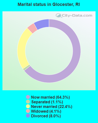
- Never married: 22.4%
- Now married: 64.3%
- Separated: 1.1%
- Widowed: 4.1%
- Divorced: 8.0%
For population 25 years and over in Glocester:
- High school or higher: 86.9%
- Bachelor's degree or higher: 27.2%
- Graduate or professional degree: 10.4%
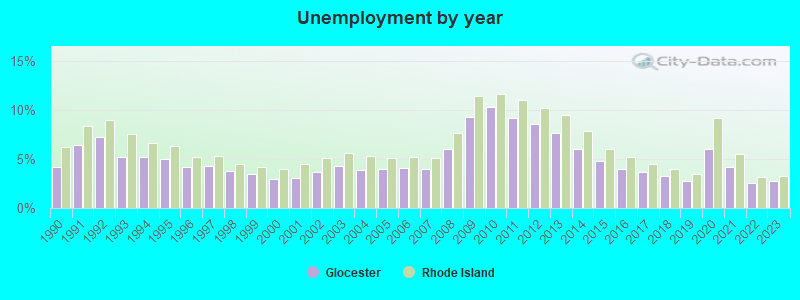
- Unemployed: 2.5%
- Mean travel time to work (commute): 30.8 minutes
| Here: | 11.0 |
| Rhode Island average: | 14.0 |
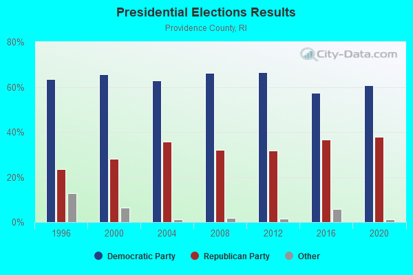
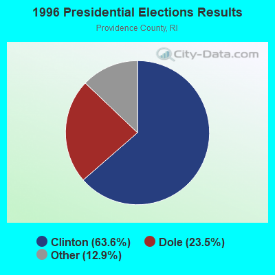
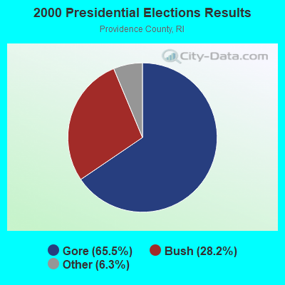
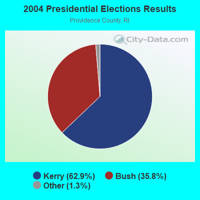
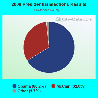
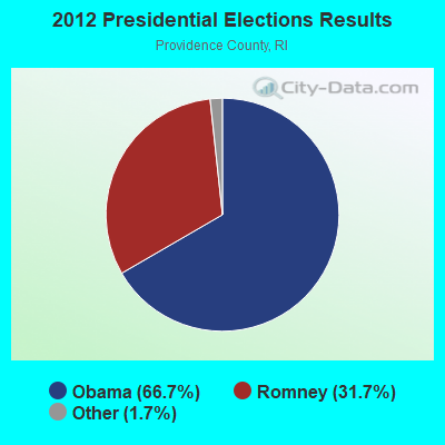
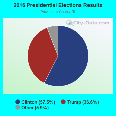
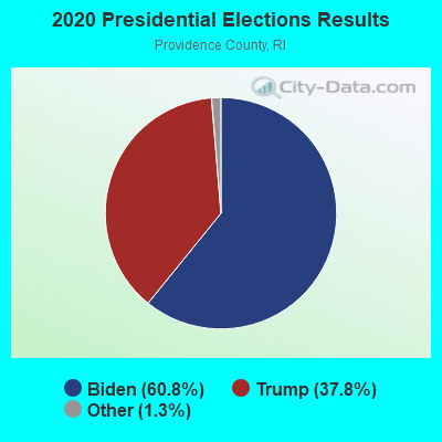
Graphs represent county-level data. Detailed 2008 Election Results
Religion statistics for Glocester, RI (based on Providence County data)
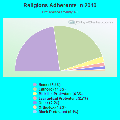
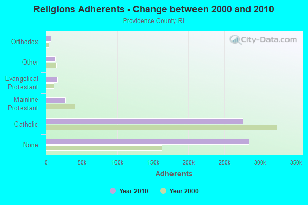
| Religion | Adherents | Congregations |
|---|---|---|
| Catholic | 276,011 | 98 |
| Mainline Protestant | 27,143 | 111 |
| Evangelical Protestant | 16,895 | 134 |
| Other | 13,896 | 48 |
| Orthodox | 7,325 | 10 |
| Black Protestant | 712 | 9 |
| None | 284,685 | - |
Food Environment Statistics:
| Providence County: | 2.06 / 10,000 pop. |
| Rhode Island: | 1.92 / 10,000 pop. |
| This county: | 0.02 / 10,000 pop. |
| State: | 0.05 / 10,000 pop. |
| Providence County: | 1.50 / 10,000 pop. |
| Rhode Island: | 1.42 / 10,000 pop. |
| Providence County: | 2.10 / 10,000 pop. |
| State: | 2.24 / 10,000 pop. |
| Here: | 7.96 / 10,000 pop. |
| State: | 9.75 / 10,000 pop. |
| This county: | 8.1% |
| Rhode Island: | 7.9% |
| Providence County: | 24.0% |
| Rhode Island: | 22.6% |
| This county: | 16.9% |
| State: | 16.3% |
5.01% of this county's 2021 resident taxpayers lived in other counties in 2020 ($66,379 average adjusted gross income)
| Here: | 5.01% |
| Rhode Island average: | 5.99% |
0.03% of residents moved from foreign countries ($121 average AGI)
Providence County: 0.03% Rhode Island average: 0.03%
Top counties from which taxpayers relocated into this county between 2020 and 2021:
| from Kent County, RI | |
| from Bristol County, MA | |
| from Suffolk County, MA |
5.35% of this county's 2020 resident taxpayers moved to other counties in 2021 ($68,172 average adjusted gross income)
| Here: | 5.35% |
| Rhode Island average: | 5.97% |
0.01% of residents moved to foreign countries ($59 average AGI)
Providence County: 0.01% Rhode Island average: 0.02%
Top counties to which taxpayers relocated from this county between 2020 and 2021:
| to Kent County, RI | |
| to Bristol County, MA | |
| to Washington County, RI |
Businesses in Glocester, RI
- CVS: 1
Strongest AM radio stations in Glocester:
- WALE (990 AM; 50 kW; GREENVILLE, RI; Owner: NORTH AMERICAN BROADCASTING CO., INC.)
- WCRN (830 AM; 50 kW; WORCESTER, MA; Owner: CARTER BROADCASTING CORPORATION)
- WEEI (850 AM; 50 kW; BOSTON, MA; Owner: ENTERCOM BOSTON LICENSE, LLC)
- WRNI (1290 AM; 10 kW; PROVIDENCE, RI; Owner: WRNI FOUNDATION)
- WKOX (1200 AM; 50 kW; FRAMINGHAM, MA; Owner: CAPSTAR TX LIMITED PARTNERSHIP)
- WBIX (1060 AM; 40 kW; NATICK, MA; Owner: LANGER BROADCASTING CORPORATION)
- WAMG (890 AM; 25 kW; DEDHAM, MA; Owner: MEGA COMMUNICATIONS OF DEDHAM LICENSEE, LLC)
- WDDZ (550 AM; 5 kW; PAWTUCKET, RI; Owner: ABC, INC.)
- WINY (1350 AM; 5 kW; PUTNAM, CT; Owner: OSBREY BROADCASTING COMPANY)
- WVNE (760 AM; daytime; 25 kW; LEICESTER, MA; Owner: BLOUNT MASSCOM, INC.)
- WRKO (680 AM; 50 kW; BOSTON, MA; Owner: ENTERCOM BOSTON LICENSE, LLC)
- WNNZ (640 AM; 50 kW; WESTFIELD, MA; Owner: CLEAR CHANNEL BROADCASTING LICENSES, INC.)
- WSKO (790 AM; 5 kW; PROVIDENCE, RI; Owner: CITADEL BROADCASTING COMPANY)
Strongest FM radio stations in Glocester:
- WWKX (106.3 FM; WOONSOCKET, RI; Owner: AAA ENTERTAINMENT LICENSING LLC)
- WPRO-FM (92.3 FM; PROVIDENCE, RI; Owner: CITADEL BROADCASTING COMPANY)
- WWBB (101.5 FM; PROVIDENCE, RI; Owner: CLEAR CHANNEL BROADCASTING LICENSES, INC.)
- WWLI (105.1 FM; PROVIDENCE, RI; Owner: CITADEL BROADCASTING COMPANY)
- WAAF (107.3 FM; WORCESTER, MA; Owner: ENTERCOM BOSTON LICENSE, LLC)
- WBRU (95.5 FM; PROVIDENCE, RI; Owner: BROWN BROADCASTING SERVICE, INC.)
- WSNE-FM (93.3 FM; TAUNTON, MA; Owner: CAPSTAR TX LIMITED PARTNERSHIP)
- WWRX-FM (103.7 FM; WESTERLY, RI; Owner: FNX BROADCASTING OF RHODE ISLAND, LLC)
- WHJY (94.1 FM; PROVIDENCE, RI; Owner: CAPSTAR TX LIMITED PARTNERSHIP)
- WWFX (100.1 FM; SOUTHBRIDGE, MA; Owner: CITADEL BROADCASTING COMPANY)
- WBMX (98.5 FM; BOSTON, MA; Owner: INFINITY RADIO OPERATIONS INC.)
- WJMN (94.5 FM; BOSTON, MA; Owner: AMFM RADIO LICENSES, L.L.C.)
- WBOS (92.9 FM; BROOKLINE, MA; Owner: GREATER BOSTON RADIO, INC.)
- WCRB (102.5 FM; WALTHAM, MA; Owner: CHARLES RIVER BROADCASTING WCRB LICE)
- WTKK (96.9 FM; BOSTON, MA; Owner: GREATER BOSTON RADIO, INC.)
- WROR-FM (105.7 FM; FRAMINGHAM, MA; Owner: GREATER BOSTON RADIO, INC.)
- WSRS (96.1 FM; WORCESTER, MA; Owner: CAPSTAR TX LIMITED PARTNERSHIP)
- WBVC (91.1 FM; POMFRET, CT; Owner: POMFRET SCHOOL)
- WSKO-FM (99.7 FM; WAKEFIELD-PEACEDALE, RI; Owner: CITADEL BROADCASTING COMPANY)
- WGBH (89.7 FM; BOSTON, MA; Owner: WGBH EDUCATIONAL FOUNDATION)
TV broadcast stations around Glocester:
- WPXQ (Channel 69; BLOCK ISLAND, RI; Owner: OCEAN STATE TELEVISION, L.L.C.)
- WRIW-LP (Channel 50; PROVIDENCE, RI; Owner: ZGS PROVIDENCE, INC.)
- WNAC-TV (Channel 64; PROVIDENCE, RI; Owner: WNAC, LLC)
- WPRI-TV (Channel 12; PROVIDENCE, RI; Owner: TVL BROADCASTING OF RHODE ISLAND, LLC)
- WJAR (Channel 10; PROVIDENCE, RI; Owner: OUTLET BROADCASTING, INC.)
- WLNE-TV (Channel 6; NEW BEDFORD, MA; Owner: FREEDOM BROADCASTING OF SOUTHERN NEW ENGLAND, INC.)
- WUNI (Channel 27; WORCESTER, MA; Owner: ENTRAVISION HOLDINGS, LLC)
- WCVB-TV (Channel 5; BOSTON, MA; Owner: WCVB HEARST-ARGYLE TV, INC.)
- WSBE-TV (Channel 36; PROVIDENCE, RI; Owner: RHODE ISLAND PUBLIC TELECOM. AUTHORITY)
- WGBH-TV (Channel 2; BOSTON, MA; Owner: WGBH EDUCATIONAL FOUNDATION)
- WYDN (Channel 48; WORCESTER, MA; Owner: EDUCATIONAL PUBLIC TV CORPORATION)
- WHDH-TV (Channel 7; BOSTON, MA; Owner: WHDH-TV)
- WMFP (Channel 62; LAWRENCE, MA; Owner: WSAH LICENSE, INC.)
- WUTF (Channel 66; MARLBOROUGH, MA; Owner: TELEFUTURA BOSTON LLC)
- WSBK-TV (Channel 38; BOSTON, MA; Owner: VIACOM INC.)
- WBZ-TV (Channel 4; BOSTON, MA; Owner: VIACOM INC.)
- WGBX-TV (Channel 44; BOSTON, MA; Owner: WGBH EDUCATIONAL FOUNDATION)
- WLVI-TV (Channel 56; CAMBRIDGE, MA; Owner: WLVI, INC.)
- WFXT (Channel 25; BOSTON, MA; Owner: FOX TELEVISION STATIONS INC.)
- WWDP (Channel 46; NORWELL, MA; Owner: NORWELL TELEVISION, LLC)
- WHPX (Channel 26; NEW LONDON, CT; Owner: PAXSON HARTFORD LICENSE, INC.)
- W40BO (Channel 40; BOSTON, MA; Owner: PAXSON COMMUNICATIONS LPTV, INC.)
- WBPX (Channel 68; BOSTON, MA; Owner: PAXSON BOSTON-68 LICENSE, INC.)
- National Bridge Inventory (NBI) Statistics
- 3Number of bridges
- 23ft / 6.9mTotal length
- $2,558,000Total costs
- 24,101Total average daily traffic
- 649Total average daily truck traffic
- 28,156Total future (year 2036) average daily traffic
FCC Registered Antenna Towers:
3- Michael J Umano, 434 Willie Woodhead Road (Lat: 41.887778 Lon: -71.755889), Type: 45.7, Structure height: 44007 m, Overall height: 45.7 m, Licensee ID: L, Registrant: Industrial Tower And Wireless, LLC, Kevin.Delaney@induscom.Com, , Marsh-field, Phone: (781) 319-1011
- Michael J Umano, 434 Willie Woodhead Road (Lat: 41.887778 Lon: -71.755889), Type: 45.7, Structure height: 44007 m, Overall height: 45.7 m, Licensee ID: L, Registrant: Industrial Tower And Wireless, LLC, Kevin.Delaney@induscom.Com, , Marsh-field, Phone: (781) 319-1011
- Michael J Umano, 434 Willie Woodhead Road (Lat: 41.887778 Lon: -71.755889), Type: 45.7, Structure height: 44007 m, Overall height: 45.7 m, Registrant: Industrial Tower And Wireless, LLC, Kevin.Delaney@induscom.Com, , Marsh-field, Phone: (781) 319-1011
FCC Registered Broadcast Land Mobile Towers:
3- Snake Hill Rd Across From Pole 245 (Lat: 41.869278 Lon: -71.689500), Call Sign: KDH299,
Assigned Frequencies: 42.9600 MHz, Grant Date: 10/13/2021, Expiration Date: 12/22/2031, Registrant: Business Radio Licensing, 30251 Golden Lantern Ste E #501, Laguna Niguel, CA 92677-5993, Phone: (949) 348-8510, Fax: (949) 348-8514, Email:
- Police Station 162 Chopmist Hill Road (Lat: 41.595833 Lon: -71.668333), Structure height: 0 m, Call Sign: WPWB539,
Assigned Frequencies: 72.4800 MHz, Grant Date: 10/06/2022, Expiration Date: 10/04/2032, Certifier: Stuart D Pearson, Registrant: Town Of Glocester, 162 Chopmist Hill Road, Chepachet, RI 02814, Phone: (401) 568-2533, Fax: (401) 568-3280, Email:
- GW MGT AREA, George Wash Mgmt Area Burrillville (Lat: 41.922222 Lon: -71.770833), Type: Tower, Structure height: 30.2 m, Call Sign: WPWE336,
Assigned Frequencies: 31.6200 MHz, 31.7400 MHz, Grant Date: 10/28/2002, Expiration Date: 10/28/2012, Cancellation Date: 12/29/2012, Certifier: Thomas G Bourn, Registrant: Fcca, 4045 Jockey Street, Charlton, NY 12019, Phone: (518) 399-6755, Fax: (518) 399-6755, Email:
FCC Registered Microwave Towers:
3- Harmony Twr, 296 Putnam Pike (Lat: 41.888917 Lon: -71.604861), Type: Ltower, Structure height: 57.9 m, Call Sign: WQXD779,
Assigned Frequencies: 17980.0 MHz, 18060.0 MHz, 17980.0 MHz, 18060.0 MHz, Grant Date: 02/08/2016, Expiration Date: 02/08/2026, Certifier: Bill Flynn, Registrant: Marcus Radio, Manchester, CT 06042, Phone: (860) 646-1839, Fax: (860) 649-8492, Email:
- RUSTIC HILL, 7 Rustic Hill Rd (Lat: 41.867361 Lon: -71.679194), Type: Ltower, Structure height: 55.8 m, Overall height: 59.4 m, Call Sign: WRDX825,
Assigned Frequencies: 19345.0 MHz, 19345.0 MHz, 19345.0 MHz, 19345.0 MHz, 19345.0 MHz, 19345.0 MHz, 19345.0 MHz, 19345.0 MHz, 19345.0 MHz, 19345.0 MHz... (+10 more), Grant Date: 08/15/2019, Expiration Date: 08/15/2029, Certifier: Chris Labutti, Registrant: Marcus Communications, 33 Mitchell Dr, Manchester, CT 06045, Phone: (860) 646-1839, Email:
- WILLIE WOOD, Willie Woodhead Rd (Lat: 41.887667 Lon: -71.756056), Type: Ltower, Structure height: 57.9 m, Overall height: 59.4 m, Call Sign: WRDX826,
Assigned Frequencies: 17820.0 MHz, 17820.0 MHz, 17820.0 MHz, 17820.0 MHz, 17820.0 MHz, 17820.0 MHz, 17820.0 MHz, 17820.0 MHz, 17820.0 MHz, 17820.0 MHz, Grant Date: 08/15/2019, Expiration Date: 08/15/2029, Certifier: Chris Labutti, Registrant: Marcus Communications, 33 Mitchell Dr, Manchester, CT 06045, Phone: (860) 646-1839, Email:
FCC Registered Amateur Radio Licenses:
2- Call Sign: KD6UIT, Licensee ID: L00625803, Grant Date: 02/04/2013, Expiration Date: 04/20/2023, Certifier: Scott L Fedick, Registrant: Scott L Fedick, 1285 Hartford Pike, Glocester, RI 02814
- Call Sign: WA1UNQ, Licensee ID: L00917042, Grant Date: 11/05/2014, Expiration Date: 01/31/2025, Cancellation Date: 11/25/2019, Certifier: Richard A Calkins, Registrant: Richard A Calkins, 76 Cherry Valley Rd, Glocester, RI 02814
- 83.2%Fuel oil, kerosene, etc.
- 6.1%Bottled, tank, or LP gas
- 5.7%Wood
- 2.9%Electricity
- 1.2%Utility gas
- 0.6%Other fuel
- 0.2%Solar energy
- 73.2%Fuel oil, kerosene, etc.
- 12.4%Bottled, tank, or LP gas
- 9.3%Electricity
- 3.5%Wood
- 1.5%Utility gas
Glocester compared to Rhode Island state average:
- Unemployed percentage significantly below state average.
- Black race population percentage significantly below state average.
- Hispanic race population percentage significantly below state average.
- Foreign-born population percentage significantly below state average.
- Renting percentage significantly below state average.
- Length of stay since moving in significantly above state average.
- Number of rooms per house significantly below state average.
- House age significantly below state average.
Glocester on our top lists:
- #16 on the list of "Top 101 cities with largest percentage of females in occupations: operations specialties managers except financial managers (population 5,000+)"
- #17 on the list of "Top 101 cities with largest percentage of females in occupations: plant and system operators (population 5,000+)"
- #27 on the list of "Top 101 cities with largest percentage of males in industries: office supplies and stationery stores (population 5,000+)"
- #28 on the list of "Top 101 cities with largest percentage of females in industries: nonmetallic mineral products (population 5,000+)"
- #30 on the list of "Top 101 cities with largest percentage of females in occupations: carpenters (population 5,000+)"
- #34 on the list of "Top 101 cities with largest percentage of females in occupations: secondary school teachers (population 5,000+)"
- #37 on the list of "Top 101 cities with the lowest number of robberies per 100,000 residents (population 5,000+)"
- #39 on the list of "Top 101 cities with the lowest number of thefts per 100,000 residents (population 5,000+)"
- #43 on the list of "Top 101 cities with largest percentage of males in occupations: special education teachers (population 5,000+)"
- #62 on the list of "Top 101 cities with largest percentage of males in occupations: registered nurses (population 5,000+)"
- #68 on the list of "Top 101 cities with largest percentage of females in industries: building material and garden equipment and supplies dealers (population 5,000+)"
- #90 on the list of "Top 101 cities with the lowest city-data.com crime index (population 5,000+)"
- #17 on the list of "Top 101 counties with highest percentage of residents voting for Obama (Democrat) in the 2012 Presidential Election"
- #18 on the list of "Top 101 counties with the lowest percentage of residents that keep firearms around their homes"
- #20 on the list of "Top 101 counties with the most Catholic congregations"
- #38 on the list of "Top 101 counties with the most Orthodox adherents"
- #46 on the list of "Top 101 counties with the most Catholic adherents"

|
|
Total of 15 patent applications in 2008-2024.