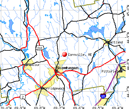
Cornville, Maine
Submit your own pictures of this town and show them to the world
- OSM Map
- General Map
- Google Map
- MSN Map
Population change since 2000: +8.8%
 |
| Males: 653 | |
| Females: 661 |
| Median resident age: | 43.1 years |
| Maine median age: | 43.0 years |
Zip codes: 04976.
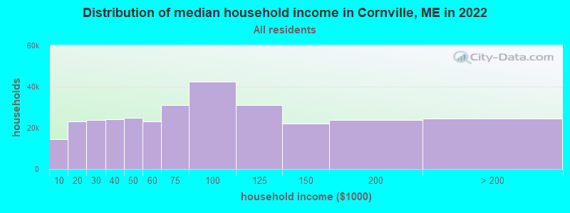
| Cornville: | $67,468 |
| ME: | $69,543 |
Estimated per capita income in 2022: $34,000 (it was $16,184 in 2000)
Cornville town income, earnings, and wages data
Estimated median house or condo value in 2022: $203,723 (it was $76,400 in 2000)
| Cornville: | $203,723 |
| ME: | $290,600 |
Mean prices in 2022: all housing units: $190,782; detached houses: $204,176; townhouses or other attached units: $200,500; in 2-unit structures: $144,246; in 3-to-4-unit structures: $441,593; in 5-or-more-unit structures: $270,949; mobile homes: $101,406; occupied boats, rvs, vans, etc.: $711,279
Detailed information about poverty and poor residents in Cornville, ME


- 1,28597.8%White alone
- 110.8%Black alone
- 80.6%Two or more races
- 60.5%Hispanic
- 30.2%Asian alone
- 10.08%American Indian alone

Races in Cornville detailed stats: ancestries, foreign born residents, place of birth
According to our research of Maine and other state lists, there were 8 registered sex offenders living in Cornville, Maine as of April 26, 2024.
The ratio of all residents to sex offenders in Cornville is 164 to 1.
 Recent articles from our blog. Our writers, many of them Ph.D. graduates or candidates, create easy-to-read articles on a wide variety of topics.

 | Photos of Maine (4586 replies) |
| Buying and building in Maine. (51 replies) |
| Yard Sale Scores (53 replies) |
| French Recipes (12 replies) |
| Bow hunting questions? (9 replies) |
Latest news from Cornville, ME collected exclusively by city-data.com from local newspapers, TV, and radio stations
Ancestries: English (21.8%), United States (11.5%), French (11.1%), Irish (10.4%), French Canadian (8.9%), German (6.5%).
Current Local Time: EST time zone
Incorporated on 02/24/1798
Elevation: 460 feet
Land area: 40.4 square miles.
Population density: 32 people per square mile (very low).
18 residents are foreign born
| This town: | 1.5% |
| Maine: | 2.9% |
| Cornville town: | 1.2% ($912) |
| Maine: | 1.5% ($1,417) |
Nearest city with pop. 50,000+: Portland, ME  (87.2 miles , pop. 64,249).
Nearest city with pop. 200,000+: Boston, MA (188.7 miles , pop. 589,141).
Nearest city with pop. 1,000,000+: Bronx, NY (348.9 miles , pop. 1,332,650).
Nearest cities:
), ), )Latitude: 44.86 N, Longitude: 69.70 W
Area code commonly used in this area: 207

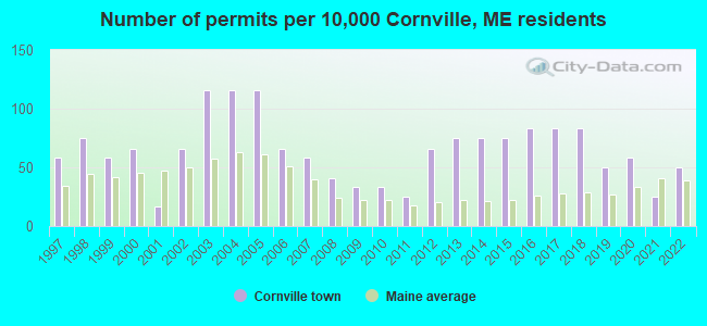
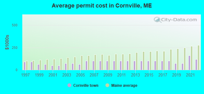
Single-family new house construction building permits:
- 2022: 6 buildings, average cost: $117,500
- 2021: 3 buildings, average cost: $160,000
- 2020: 7 buildings, average cost: $75,000
- 2019: 6 buildings, average cost: $75,000
- 2018: 10 buildings, average cost: $100,000
- 2017: 10 buildings, average cost: $100,000
- 2016: 10 buildings, average cost: $100,000
- 2015: 9 buildings, average cost: $100,000
- 2014: 9 buildings, average cost: $100,000
- 2013: 9 buildings, average cost: $100,000
- 2012: 8 buildings, average cost: $100,000
- 2011: 3 buildings, average cost: $100,000
- 2010: 4 buildings, average cost: $100,000
- 2009: 4 buildings, average cost: $100,000
- 2008: 5 buildings, average cost: $100,000
- 2007: 7 buildings, average cost: $100,000
- 2006: 8 buildings, average cost: $100,000
- 2005: 14 buildings, average cost: $64,300
- 2004: 14 buildings, average cost: $75,000
- 2003: 14 buildings, average cost: $75,000
- 2002: 8 buildings, average cost: $50,000
- 2001: 2 buildings, average cost: $50,000
- 2000: 8 buildings, average cost: $64,300
- 1999: 7 buildings, average cost: $64,300
- 1998: 9 buildings, average cost: $91,700
- 1997: 7 buildings, average cost: $91,700
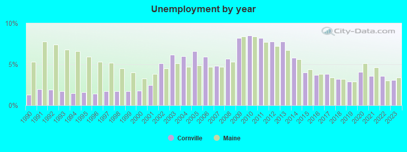
| Here: | 3.1% |
| Maine: | 3.4% |
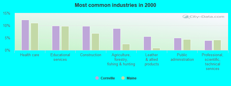
- Health care (12.4%)
- Educational services (9.9%)
- Construction (9.8%)
- Agriculture, forestry, fishing & hunting (8.9%)
- Leather & allied products (5.6%)
- Public administration (5.1%)
- Professional, scientific, technical services (4.0%)
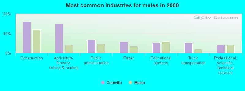
- Construction (16.1%)
- Agriculture, forestry, fishing & hunting (14.9%)
- Public administration (6.8%)
- Paper (5.9%)
- Educational services (5.3%)
- Truck transportation (5.3%)
- Professional, scientific, technical services (4.3%)
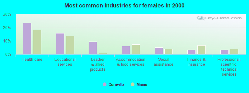
- Health care (23.8%)
- Educational services (15.9%)
- Leather & allied products (9.5%)
- Accommodation & food services (6.3%)
- Social assistance (5.2%)
- Finance & insurance (3.6%)
- Professional, scientific, technical services (3.6%)
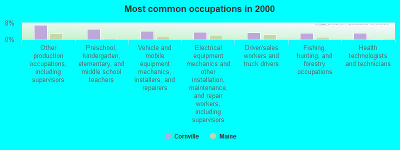
- Other production occupations, including supervisors (7.0%)
- Preschool, kindergarten, elementary, and middle school teachers (5.1%)
- Vehicle and mobile equipment mechanics, installers, and repairers (4.0%)
- Electrical equipment mechanics and other installation, maintenance, and repair workers, including supervisors (3.7%)
- Driver/sales workers and truck drivers (3.3%)
- Fishing, hunting, and forestry occupations (3.1%)
- Health technologists and technicians (3.1%)
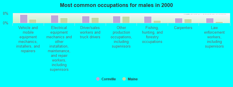
- Vehicle and mobile equipment mechanics, installers, and repairers (7.1%)
- Electrical equipment mechanics and other installation, maintenance, and repair workers, including supervisors (6.5%)
- Driver/sales workers and truck drivers (5.9%)
- Other production occupations, including supervisors (5.9%)
- Fishing, hunting, and forestry occupations (5.6%)
- Carpenters (4.0%)
- Law enforcement workers, including supervisors (4.0%)
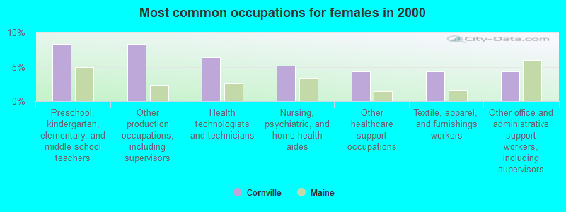
- Preschool, kindergarten, elementary, and middle school teachers (8.3%)
- Other production occupations, including supervisors (8.3%)
- Health technologists and technicians (6.3%)
- Nursing, psychiatric, and home health aides (5.2%)
- Other healthcare support occupations (4.4%)
- Textile, apparel, and furnishings workers (4.4%)
- Other office and administrative support workers, including supervisors (4.4%)
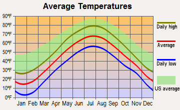
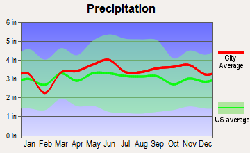
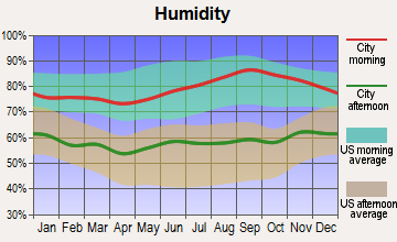
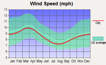
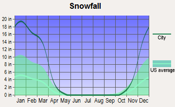
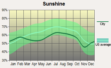
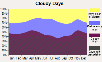
Average climate in Cornville, Maine
Based on data reported by over 4,000 weather stations
Earthquake activity:
Cornville-area historical earthquake activity is significantly above Maine state average. It is 80% smaller than the overall U.S. average.On 4/20/2002 at 10:50:47, a magnitude 5.3 (5.3 ML, Depth: 3.0 mi, Class: Moderate, Intensity: VI - VII) earthquake occurred 198.1 miles away from Cornville center
On 4/20/2002 at 10:50:47, a magnitude 5.2 (5.2 MB, 4.2 MS, 5.2 MW, 5.0 MW) earthquake occurred 199.4 miles away from Cornville center
On 10/16/2012 at 23:12:25, a magnitude 4.7 (4.7 ML, Depth: 10.0 mi, Class: Light, Intensity: IV - V) earthquake occurred 99.3 miles away from Cornville center
On 10/7/1983 at 10:18:46, a magnitude 5.3 (5.1 MB, 5.3 LG, 5.1 ML) earthquake occurred 237.8 miles away from the city center
On 1/19/1982 at 00:14:42, a magnitude 4.7 (4.5 MB, 4.7 MD, 4.5 LG) earthquake occurred 133.1 miles away from the city center
On 2/26/1999 at 03:38:43, a magnitude 3.8 (3.8 LG, Depth: 2.0 mi, Class: Light, Intensity: II - III) earthquake occurred 27.5 miles away from Cornville center
Magnitude types: regional Lg-wave magnitude (LG), body-wave magnitude (MB), duration magnitude (MD), local magnitude (ML), surface-wave magnitude (MS), moment magnitude (MW)
Natural disasters:
The number of natural disasters in Somerset County (24) is greater than the US average (15).Major Disasters (Presidential) Declared: 16
Emergencies Declared: 7
Causes of natural disasters: Floods: 14, Storms: 13, Snows: 7, Heavy Rains: 2, Hurricanes: 2, Blizzard: 1, Ice Storm: 1, Landslide: 1, Snowfall: 1, Wind: 1, Winter Storm: 1, Other: 1 (Note: some incidents may be assigned to more than one category).
Hospitals and medical centers near Cornville:
- WOODLAWN REHABILITATION AND NURSING CENTER (Nursing Home, about 7 miles away; SKOWHEGAN, ME)
- REDINGTON FAIRVIEW GENERAL HOSPITAL Critical Access Hospitals (about 8 miles away; SKOWHEGAN, ME)
- MAPLECREST REHAB AND LIVING CENTER (Nursing Home, about 10 miles away; MADISON, ME)
- SANFIELD REHAB AND LIVING CENTER (Nursing Home, about 13 miles away; HARTLAND, ME)
Colleges/universities with over 2000 students nearest to Cornville:
- University of Maine at Farmington (about 26 miles; Farmington, ME; Full-time enrollment: 2,036)
- University of Maine at Augusta (about 37 miles; Augusta, ME; FT enrollment: 3,204)
- Husson University (about 45 miles; Bangor, ME; FT enrollment: 2,421)
- University of Maine (about 51 miles; Orono, ME; FT enrollment: 8,931)
- Saint Joseph's College of Maine (about 82 miles; Standish, ME; FT enrollment: 2,010)
- University of Southern Maine (about 88 miles; Portland, ME; FT enrollment: 6,647)
- Southern Maine Community College (about 88 miles; South Portland, ME; FT enrollment: 4,666)
Private high school in Cornville:
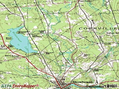
Points of interest:
Notable location: Cornville Volunteer Fire Department (A). Display/hide its location on the map
Shopping Center: Kennebec Village Shopping Center (1). Display/hide its location on the map
Church in Cornville: Cornville Church (A). Display/hide its location on the map
Cemeteries: Richards Cemetery (1), Kinsman Cemetery (2), East Ridge Cemetery (3). Display/hide their locations on the map
Lakes: Barker Pond (A), Devils Bog (B), Smith Pond (C). Display/hide their locations on the map
Streams, rivers, and creeks: Mill Stream (A), Longley Brook (B), Paine Brook (C), Kincaid Stream (D), Haley Brook (E), Bog Brook (F). Display/hide their locations on the map
Birthplace of: Luther Elkins - Politician.
Drinking water stations with addresses in Cornville and their reported violations in the past:
CORNVILLE REGIONAL CHARTER SCHOOL (Population served: 107, Groundwater):Past monitoring violations:
- 2 routine major monitoring violations
| This town: | 2.5 people |
| Maine: | 2.3 people |
| This town: | 71.9% |
| Whole state: | 62.9% |
| This town: | 10.5% |
| Whole state: | 9.4% |
Likely homosexual households (counted as self-reported same-sex unmarried-partner households)
- Lesbian couples: 0.2% of all households
- Gay men: 0.2% of all households
| This town: | 11.5% |
| Whole state: | 10.9% |
| This town: | 2.8% |
| Whole state: | 4.1% |
For population 15 years and over in Cornville:
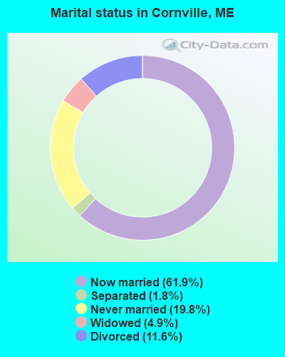
- Never married: 19.8%
- Now married: 61.9%
- Separated: 1.8%
- Widowed: 4.9%
- Divorced: 11.6%
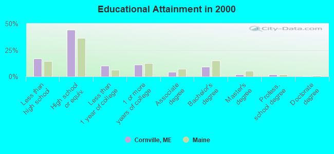
For population 25 years and over in Cornville:
- High school or higher: 83.2%
- Bachelor's degree or higher: 13.4%
- Graduate or professional degree: 4.0%
- Unemployed: 4.0%
- Mean travel time to work (commute): 30.1 minutes
| Here: | 10.0 |
| Maine average: | 11.2 |

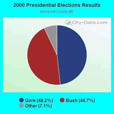
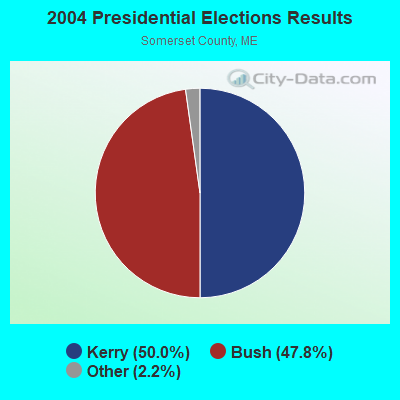
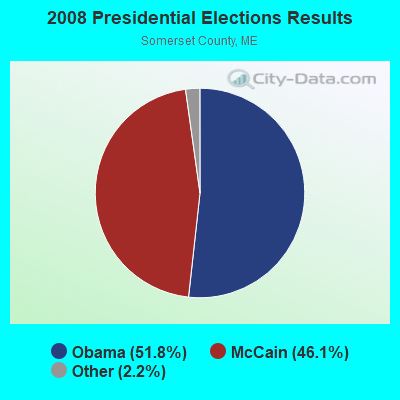
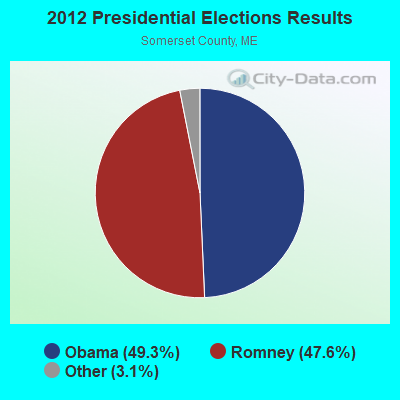
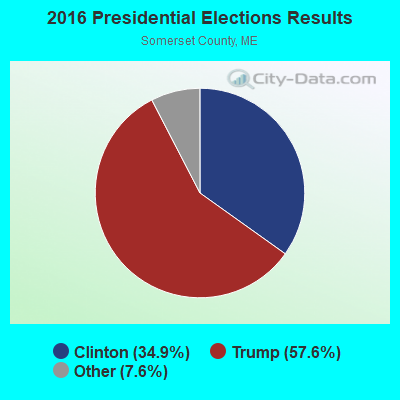
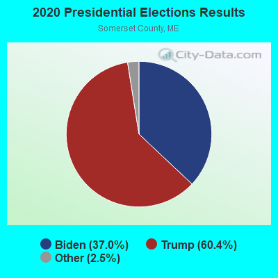
Graphs represent county-level data. Detailed 2008 Election Results
Religion statistics for Cornville, ME (based on Somerset County data)
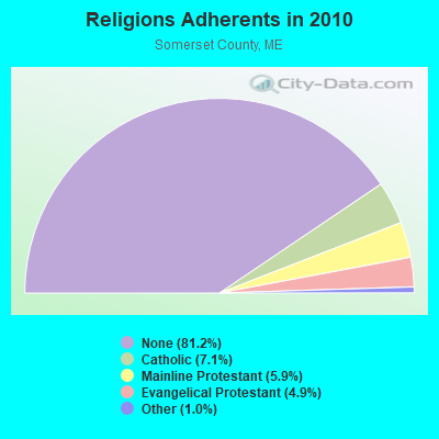
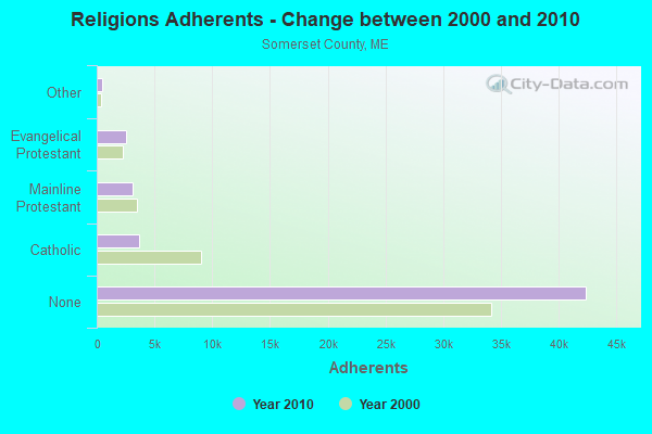
| Religion | Adherents | Congregations |
|---|---|---|
| Catholic | 3,694 | 7 |
| Mainline Protestant | 3,094 | 28 |
| Evangelical Protestant | 2,552 | 32 |
| Other | 501 | 3 |
| None | 42,387 | - |
Food Environment Statistics:
| Somerset County: | 2.52 / 10,000 pop. |
| Maine: | 2.80 / 10,000 pop. |
| Somerset County: | 0.19 / 10,000 pop. |
| Maine: | 0.14 / 10,000 pop. |
| This county: | 2.71 / 10,000 pop. |
| Maine: | 2.20 / 10,000 pop. |
| Somerset County: | 9.31 / 10,000 pop. |
| Maine: | 5.75 / 10,000 pop. |
| Somerset County: | 8.14 / 10,000 pop. |
| Maine: | 11.02 / 10,000 pop. |
| This county: | 10.2% |
| Maine: | 8.2% |
| Somerset County: | 31.7% |
| Maine: | 25.0% |
Strongest AM radio stations in Cornville:
- WSKW (1160 AM; 10 kW; SKOWHEGAN, ME; Owner: MOUNTAIN WIRELESS, INCORPORATED)
- WTME (780 AM; 10 kW; RUMFORD, ME; Owner: MOUNTAIN VALLEY BROADCASTING, INC.)
- WZON (620 AM; 5 kW; BANGOR, ME; Owner: THE ZONE CORPORATION)
- WABI (910 AM; 5 kW; BANGOR, ME; Owner: CLEAR CHANNEL BROADCASTING LICENSES, INC.)
- WFAU (1280 AM; 5 kW; GARDINER, ME; Owner: CAPSTAR TX LIMITED PARTNERSHIP)
- WRKO (680 AM; 50 kW; BOSTON, MA; Owner: ENTERCOM BOSTON LICENSE, LLC)
- WTVL (1490 AM; 1 kW; WATERVILLE, ME; Owner: CITADEL BROADCASTING COMPANY)
- WEEI (850 AM; 50 kW; BOSTON, MA; Owner: ENTERCOM BOSTON LICENSE, LLC)
- WBZ (1030 AM; 50 kW; BOSTON, MA; Owner: INFINITY BROADCASTING OPERATIONS, INC.)
- WMTW (870 AM; 10 kW; GORHAM, ME; Owner: RADIO PARTNERS OF MAINE, L.P.)
- WCHP (760 AM; 35 kW; CHAMPLAIN, NY; Owner: CHAMPLAIN RADIO, INC.)
- WCRN (830 AM; 50 kW; WORCESTER, MA; Owner: CARTER BROADCASTING CORPORATION)
- WNNZ (640 AM; 50 kW; WESTFIELD, MA; Owner: CLEAR CHANNEL BROADCASTING LICENSES, INC.)
Strongest FM radio stations in Cornville:
- WHQO (107.9 FM; SKOWHEGAN, ME; Owner: MOUNTAIN WIRELESS, INC.)
- WTOS-FM (105.1 FM; SKOWHEGAN, ME; Owner: CAPSTAR TX LIMITED PARTNERSHIP)
- WCTB (93.5 FM; FAIRFIELD, ME; Owner: MOUNTAIN WIRELESS, INC.)
- WQCB (106.5 FM; BREWER, ME; Owner: CUMULUS LICENSING CORP.)
- WWBX (97.1 FM; BANGOR, ME; Owner: CLEAR CHANNEL BROADCASTING LICENSES, INC.)
- WGUY (102.1 FM; DEXTER, ME; Owner: CONCORD MEDIA GROUP, INC.)
- WIGY (97.5 FM; MADISON, ME; Owner: CAPSTAR TX LIMITED PARTNERSHIP)
- WWWA (95.3 FM; WINSLOW, ME; Owner: LIGHT OF LIFE MINISTRIES, INC.)
- WLOB-FM (96.3 FM; RUMFORD, ME; Owner: ATLANTIC COAST RADIO, LLC)
- WBFB (104.7 FM; BELFAST, ME; Owner: CLEAR CHANNEL BROADCASTING LICENSES, INC.)
- WTBM (100.7 FM; MEXICO, ME; Owner: MOUNTAIN VALLEY BROADCASTING, INC.)
- WJCX (99.5 FM; PITTSFIELD, ME; Owner: CSN INTERNATIONAL)
- WEBB (98.5 FM; WATERVILLE, ME; Owner: CITADEL BROADCASTING COMPANY)
- WKTJ-FM (99.3 FM; FARMINGTON, ME; Owner: FRANKLIN BROADCASTING CORPORATION)
Cornville fatal accident list:
Oct 9, 2016 08:55 PM, Sr-Shadagee Road, Lat: 44.896953, Lon: -69.746092, Vehicles: 1, Persons: 1, Fatalities: 1, Drunk persons involved: 1
Dec 30, 2011 11:10 PM, West Ridge Road, Lat: 44.823419, Lon: -69.669217, Vehicles: 2, Persons: 1, Fatalities: 1, Drunk persons involved: 1
Aug 5, 2010 00:00 AM, Molunkus Road, Lat: 44.810522, Lon: -69.714003, Vehicles: 1, Persons: 1, Fatalities: 1, Drunk persons involved: 1
Jun 24, 2007 00:35 AM, Moody Train Road, Lat: 44.868094, Lon: -69.645267, Vehicles: 1, Persons: 1, Fatalities: 1, Drunk persons involved: 1
May 27, 2006 08:15 PM, East Ridge Road, Lat: 44.887820, Lon: -69.659570, Vehicles: 2, Persons: 4, Fatalities: 3, Drunk persons involved: 1
- National Bridge Inventory (NBI) Statistics
- 5Number of bridges
- 26ft / 7.5mTotal length
- 2,815Total average daily traffic
- 138Total average daily truck traffic
- 4,263Total future (year 2036) average daily traffic
FCC Registered Broadcast Land Mobile Towers:
1- Lat: 44.897833 Lon: -69.744389, Call Sign: WQDI264,
Assigned Frequencies: 152.915 MHz, 159.915 MHz, 159.945 MHz, 159.960 MHz, 160.050 MHz, Grant Date: 07/16/2015, Expiration Date: 09/01/2025, Certifier: Danny Bosworth, Registrant: Bosworth Farms Inc, 457 Shadagee Rd, Cornville, ME 04976, Phone: (207) 474-0680, Email:
FCC Registered Microwave Towers:
1- Comville, 949 West Ridge Rd (Lat: 44.878389 Lon: -69.686028), Type: Ltower, Structure height: 59.7 m, Overall height: 60.7 m, Call Sign: WQSJ593,
Assigned Frequencies: 17915.0 MHz, 17915.0 MHz, 17915.0 MHz, 17915.0 MHz, 17915.0 MHz, 17915.0 MHz, 17915.0 MHz, 17915.0 MHz, 17915.0 MHz, Grant Date: 09/27/2013, Expiration Date: 09/27/2023, Cancellation Date: 04/15/2020, Certifier: Jessica B Lyons, Registrant: At&t Services, Inc., 208 S Akard St, Rm 2100, Dallas, TX 75202, Phone: (855) 699-7073, Fax: (214) 746-6410, Email:
FCC Registered Amateur Radio Licenses:
4- Call Sign: N1LHI, Previous Call Sign: KA1JIH, Licensee ID: L00459472, Grant Date: 01/28/1992, Expiration Date: 01/28/2002, Cancellation Date: 02/02/2002, Registrant: Robert G Mc Cann, 820 Eastridge Road, Cornville, ME 04976
- Call Sign: N1SJZ, Licensee ID: L00507256, Grant Date: 07/22/2014, Expiration Date: 07/22/2024, Certifier: John S Mackenzie, Registrant: John S Mackenzie, 75 Thurston Rd, Cornville, ME 04976
- Call Sign: KB1HUG, Previous Call Sign: N1LHI, Licensee ID: L01898581, Grant Date: 10/31/2011, Expiration Date: 01/28/2022, Cancellation Date: 01/30/2024, Certifier: Robert G Mc Cann, Registrant: Robert G Mc Cann, 1082 Eastridge Road, Cornville, ME 04976
- Call Sign: KC1FBC, Licensee ID: L02002662, Grant Date: 02/16/2016, Expiration Date: 02/16/2026, Certifier: Hunter R Smith, Registrant: Hunter R Smith, 144 Oxbow Rd, Cornville, ME 04976
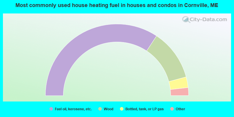
- 68.7%Fuel oil, kerosene, etc.
- 23.0%Wood
- 4.8%Bottled, tank, or LP gas
- 3.1%Electricity
- 0.5%Coal or coke
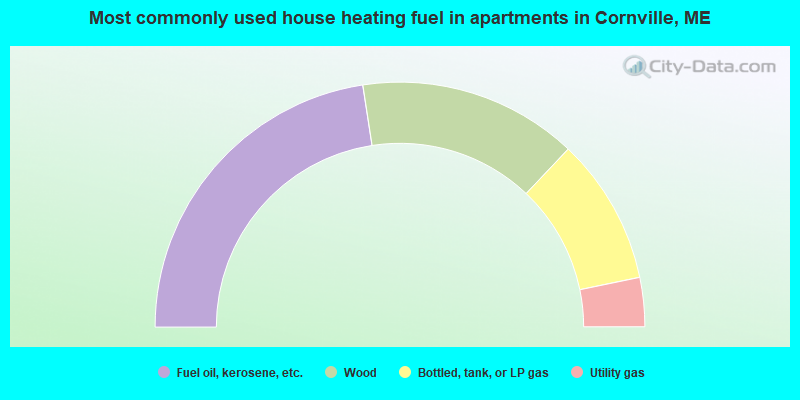
- 45.2%Fuel oil, kerosene, etc.
- 29.0%Wood
- 19.4%Bottled, tank, or LP gas
- 6.5%Utility gas
Cornville compared to Maine state average:
- Unemployed percentage significantly below state average.
- Black race population percentage below state average.
- Hispanic race population percentage significantly below state average.
- Foreign-born population percentage significantly below state average.
- Renting percentage significantly below state average.
- Length of stay since moving in significantly above state average.
- Number of rooms per house significantly below state average.
- House age significantly below state average.
- Percentage of population with a bachelor's degree or higher below state average.