Cromwell, Connecticut
Submit your own pictures of this town and show them to the world
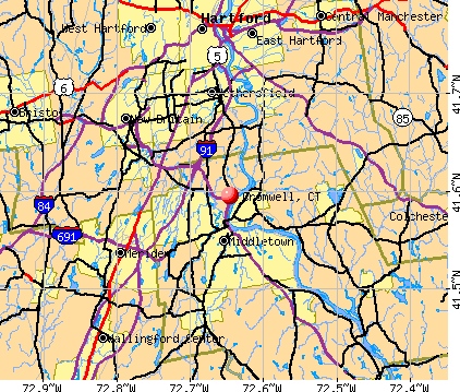
- OSM Map
- General Map
- Google Map
- MSN Map
Population change since 2000: +8.8%
 |
| Males: 6,798 | |
| Females: 7,207 |
| Median resident age: | 43.1 years |
| Connecticut median age: | 39.2 years |
Zip codes: 06416.
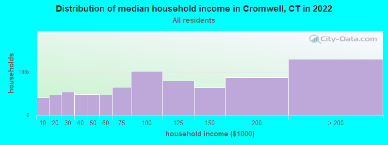
| Cromwell: | $99,458 |
| CT: | $88,429 |
Estimated per capita income in 2022: $53,410 (it was $29,786 in 2000)
Cromwell town income, earnings, and wages data
Estimated median house or condo value in 2022: $294,450 (it was $136,200 in 2000)
| Cromwell: | $294,450 |
| CT: | $347,200 |
Mean prices in 2022: all housing units: $381,367; detached houses: $403,130; townhouses or other attached units: $256,262; in 2-unit structures: $274,238; in 3-to-4-unit structures: $246,924; in 5-or-more-unit structures: $191,256; mobile homes: $82,291
Detailed information about poverty and poor residents in Cromwell, CT


- 12,13286.6%White alone
- 6334.5%Hispanic
- 5523.9%Black alone
- 4623.3%Asian alone
- 2041.5%Two or more races
- 120.09%American Indian alone
- 90.06%Other race alone
- 10.01%Native Hawaiian and Other
Pacific Islander alone
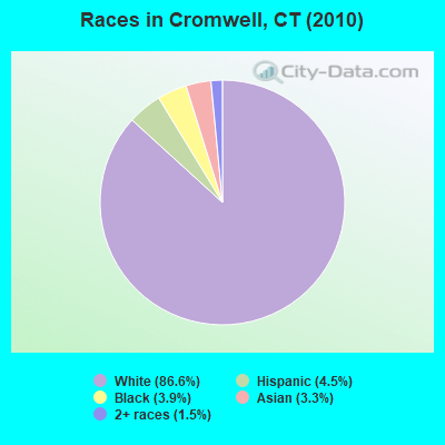
Races in Cromwell detailed stats: ancestries, foreign born residents, place of birth
According to our research of Connecticut and other state lists, there were 14 registered sex offenders living in Cromwell, Connecticut as of April 27, 2024.
The ratio of all residents to sex offenders in Cromwell is 1,000 to 1.
The ratio of registered sex offenders to all residents in this city is lower than the state average.
Type |
2009 |
2010 |
2011 |
2012 |
2013 |
2014 |
2015 |
2016 |
2017 |
2018 |
2019 |
2020 |
2021 |
2022 |
|---|---|---|---|---|---|---|---|---|---|---|---|---|---|---|
| Murders (per 100,000) | 0 (0.0) | 0 (0.0) | 0 (0.0) | 0 (0.0) | 0 (0.0) | 0 (0.0) | 0 (0.0) | 0 (0.0) | 0 (0.0) | 0 (0.0) | 0 (0.0) | 0 (0.0) | 0 (0.0) | 0 (0.0) |
| Rapes (per 100,000) | 2 (14.6) | 1 (7.1) | 1 (7.1) | 1 (7.1) | 0 (0.0) | 1 (7.0) | 0 (0.0) | 0 (0.0) | 2 (14.3) | 3 (21.5) | 1 (7.2) | 3 (21.7) | 0 (0.0) | 2 (13.9) |
| Robberies (per 100,000) | 6 (43.9) | 12 (85.7) | 4 (28.5) | 6 (42.6) | 8 (56.0) | 1 (7.0) | 5 (35.4) | 4 (28.5) | 3 (21.5) | 1 (7.2) | 2 (14.4) | 5 (36.2) | 5 (36.4) | 2 (13.9) |
| Assaults (per 100,000) | 6 (43.9) | 4 (28.6) | 1 (7.1) | 4 (28.4) | 1 (7.0) | 5 (35.2) | 6 (42.4) | 3 (21.4) | 5 (35.8) | 3 (21.5) | 2 (14.4) | 5 (36.2) | 1 (7.3) | 6 (41.8) |
| Burglaries (per 100,000) | 50 (365.6) | 48 (342.7) | 28 (199.6) | 44 (312.6) | 16 (112.0) | 27 (189.8) | 12 (84.9) | 18 (128.2) | 8 (57.3) | 30 (215.1) | 21 (151.1) | 38 (274.9) | 23 (167.3) | 28 (195.0) |
| Thefts (per 100,000) | 311 (2,274) | 290 (2,071) | 298 (2,124) | 235 (1,670) | 257 (1,798) | 275 (1,933) | 302 (2,136) | 330 (2,350) | 225 (1,613) | 205 (1,470) | 325 (2,339) | 343 (2,482) | 259 (1,884) | 382 (2,660) |
| Auto thefts (per 100,000) | 18 (131.6) | 16 (114.2) | 16 (114.0) | 13 (92.4) | 4 (28.0) | 6 (42.2) | 18 (127.3) | 23 (163.8) | 27 (193.5) | 13 (93.2) | 16 (115.2) | 24 (173.6) | 24 (174.5) | 34 (236.8) |
| Arson (per 100,000) | 1 (7.3) | 1 (7.1) | 0 (0.0) | 0 (0.0) | 0 (0.0) | 0 (0.0) | 0 (0.0) | 0 (0.0) | 0 (0.0) | 0 (0.0) | 3 (21.6) | 6 (43.4) | 1 (7.3) | 0 (0.0) |
| City-Data.com crime index | 160.7 | 153.1 | 123.7 | 120.2 | 100.2 | 108.8 | 120.6 | 128.9 | 109.1 | 104.9 | 126.3 | 167.8 | 113.4 | 162.7 |
The City-Data.com crime index weighs serious crimes and violent crimes more heavily. Higher means more crime, U.S. average is 246.1. It adjusts for the number of visitors and daily workers commuting into cities.
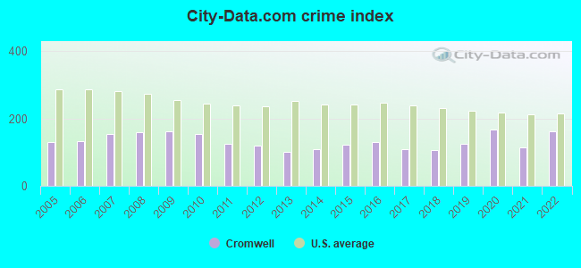
Crime rate in Cromwell detailed stats: murders, rapes, robberies, assaults, burglaries, thefts, arson
Full-time law enforcement employees in 2021, including police officers: 37 (27 officers - 23 male; 4 female).
| Officers per 1,000 residents here: | 1.96 |
| Connecticut average: | 2.10 |
 Recent articles from our blog. Our writers, many of them Ph.D. graduates or candidates, create easy-to-read articles on a wide variety of topics.

 | Does Connecticut Have the Best Pizza in America? (457 replies) |
| Apartment in Middletown/Cromwell area (7 replies) |
| Connecticut This & That (254 replies) |
| Does anyone remember these old stores in CT? (614 replies) |
| Wilton Tax Collector charged me late fees and interest (8 replies) |
| Best Walmart to Shop at (32 replies) |
Latest news from Cromwell, CT collected exclusively by city-data.com from local newspapers, TV, and radio stations
Cromwell, CT City Guides:
Ancestries: Italian (22.8%), Irish (19.7%), Polish (13.6%), English (13.4%), German (11.6%), French (5.9%).
Current Local Time: EST time zone
Incorporated on 05/1851
Elevation: 35 feet
Land area: 12.4 square miles.
Population density: 1,130 people per square mile (low).
1,100 residents are foreign born (4.7% Europe, 1.7% Latin America, 1.3% Asia).
| This town: | 8.5% |
| Connecticut: | 10.9% |
| Cromwell town: | 2.1% ($2,868) |
| Connecticut: | 1.8% ($2,961) |
Nearest city with pop. 50,000+: New Britain, CT  (7.6 miles , pop. 71,538).
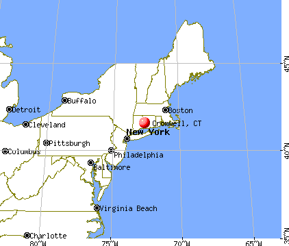
Nearest city with pop. 200,000+: North Hempstead, NY (77.6 miles , pop. 222,611).
Nearest city with pop. 1,000,000+: Bronx, NY (82.0 miles , pop. 1,332,650).
Nearest cities:
), Latitude: 41.61 N, Longitude: 72.67 W
Area code commonly used in this area: 860

Cromwell, Connecticut accommodation & food services, waste management - Economy and Business Data
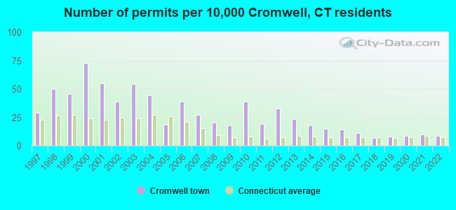
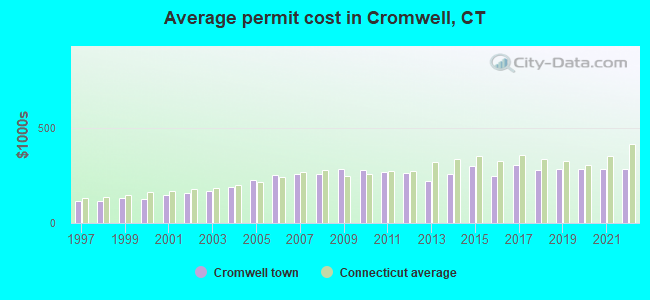
Single-family new house construction building permits:
- 2022: 11 buildings, average cost: $283,600
- 2021: 13 buildings, average cost: $283,600
- 2020: 11 buildings, average cost: $283,400
- 2019: 10 buildings, average cost: $284,100
- 2018: 9 buildings, average cost: $280,100
- 2017: 14 buildings, average cost: $304,500
- 2016: 18 buildings, average cost: $245,900
- 2015: 19 buildings, average cost: $301,500
- 2014: 23 buildings, average cost: $259,400
- 2013: 30 buildings, average cost: $218,800
- 2012: 42 buildings, average cost: $261,100
- 2011: 25 buildings, average cost: $267,800
- 2010: 50 buildings, average cost: $277,100
- 2009: 23 buildings, average cost: $285,600
- 2008: 26 buildings, average cost: $256,600
- 2007: 35 buildings, average cost: $259,900
- 2006: 50 buildings, average cost: $253,600
- 2005: 24 buildings, average cost: $227,600
- 2004: 57 buildings, average cost: $191,400
- 2003: 70 buildings, average cost: $170,800
- 2002: 50 buildings, average cost: $155,700
- 2001: 71 buildings, average cost: $147,600
- 2000: 94 buildings, average cost: $128,100
- 1999: 59 buildings, average cost: $132,100
- 1998: 64 buildings, average cost: $113,700
- 1997: 37 buildings, average cost: $113,600
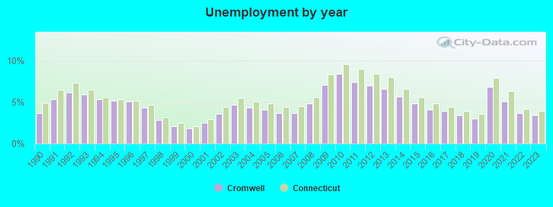
| Here: | 3.4% |
| Connecticut: | 3.9% |
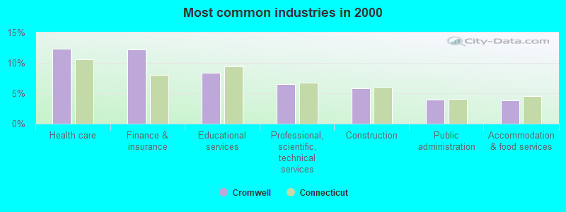
- Health care (12.4%)
- Finance & insurance (12.3%)
- Educational services (8.4%)
- Professional, scientific, technical services (6.5%)
- Construction (5.8%)
- Public administration (4.0%)
- Accommodation & food services (3.8%)
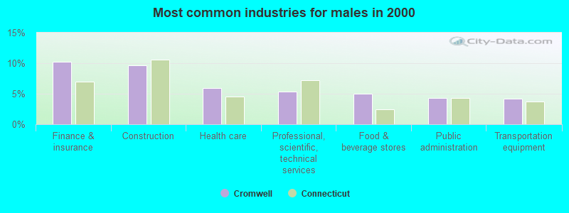
- Finance & insurance (10.2%)
- Construction (9.7%)
- Health care (5.9%)
- Professional, scientific, technical services (5.4%)
- Food & beverage stores (5.0%)
- Public administration (4.4%)
- Transportation equipment (4.2%)
- Health care (18.8%)
- Finance & insurance (14.3%)
- Educational services (13.1%)
- Professional, scientific, technical services (7.7%)
- Accommodation & food services (3.6%)
- Social assistance (3.6%)
- Public administration (3.6%)
- Other office and administrative support workers, including supervisors (5.3%)
- Other sales and related occupations, including supervisors (4.8%)
- Secretaries and administrative assistants (4.3%)
- Other management occupations, except farmers and farm managers (4.2%)
- Computer specialists (3.2%)
- Engineers (3.0%)
- Accountants and auditors (2.8%)
- Other sales and related occupations, including supervisors (5.9%)
- Other management occupations, except farmers and farm managers (5.6%)
- Engineers (5.2%)
- Material recording, scheduling, dispatching, and distributing workers (4.1%)
- Driver/sales workers and truck drivers (3.7%)
- Electrical equipment mechanics and other installation, maintenance, and repair workers, including supervisors (3.3%)
- Other production occupations, including supervisors (3.3%)
- Other office and administrative support workers, including supervisors (8.2%)
- Secretaries and administrative assistants (8.2%)
- Preschool, kindergarten, elementary, and middle school teachers (5.0%)
- Registered nurses (4.1%)
- Other sales and related occupations, including supervisors (3.6%)
- Accountants and auditors (3.5%)
- Computer specialists (3.5%)
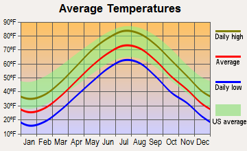
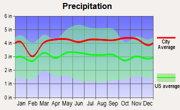
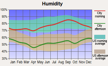
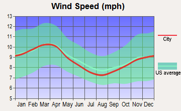
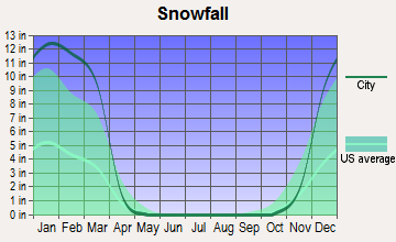
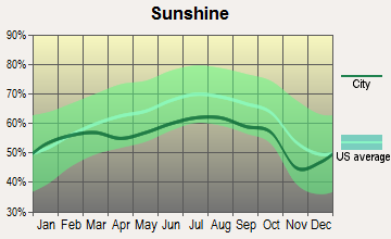
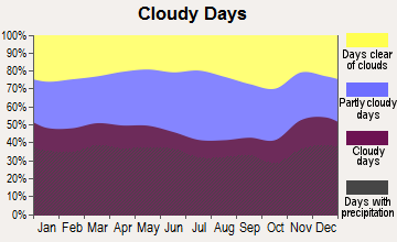
Average climate in Cromwell, Connecticut
Based on data reported by over 4,000 weather stations
(lower is better)
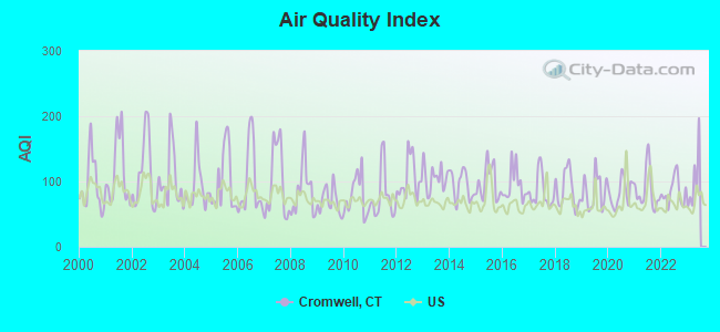
Air Quality Index (AQI) level in 2022 was 84.5. This is about average.
| City: | 84.5 |
| U.S.: | 72.6 |
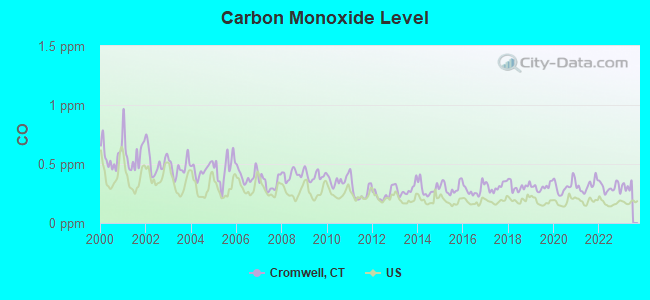
Carbon Monoxide (CO) [ppm] level in 2022 was 0.300. This is about average. Closest monitor was 7.3 miles away from the city center.
| City: | 0.300 |
| U.S.: | 0.251 |
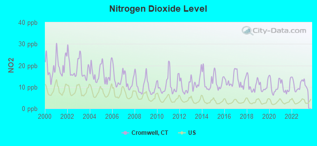
Nitrogen Dioxide (NO2) [ppb] level in 2022 was 10.8. This is significantly worse than average. Closest monitor was 3.5 miles away from the city center.
| City: | 10.8 |
| U.S.: | 5.1 |
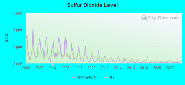
Sulfur Dioxide (SO2) [ppb] level in 2022 was 0.214. This is significantly better than average. Closest monitor was 3.5 miles away from the city center.
| City: | 0.214 |
| U.S.: | 1.515 |
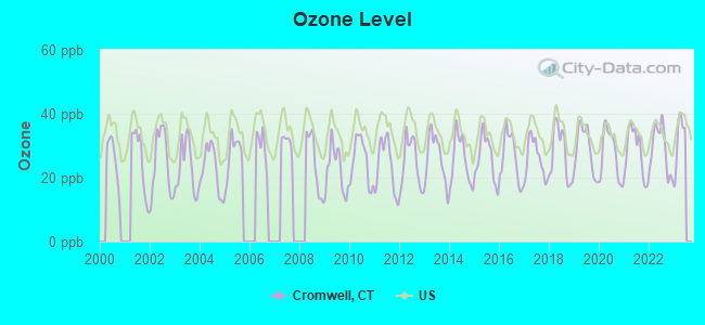
Ozone [ppb] level in 2022 was 28.9. This is about average. Closest monitor was 3.5 miles away from the city center.
| City: | 28.9 |
| U.S.: | 33.3 |
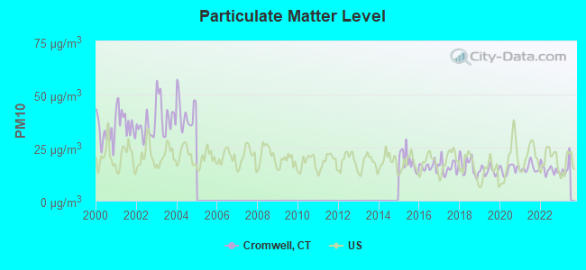
Particulate Matter (PM10) [µg/m3] level in 2022 was 14.6. This is better than average. Closest monitor was 4.6 miles away from the city center.
| City: | 14.6 |
| U.S.: | 19.2 |
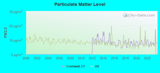
Particulate Matter (PM2.5) [µg/m3] level in 2022 was 7.37. This is about average. Closest monitor was 9.4 miles away from the city center.
| City: | 7.37 |
| U.S.: | 8.11 |
Tornado activity:
Cromwell-area historical tornado activity is near Connecticut state average. It is 26% smaller than the overall U.S. average.
On 10/3/1979, a category F4 (max. wind speeds 207-260 mph) tornado 18.7 miles away from the Cromwell town center killed 3 people and injured 500 people and caused between $50,000,000 and $500,000,000 in damages.
On 7/10/1989, a category F4 tornado 20.0 miles away from the town center injured 40 people and caused between $50,000,000 and $500,000,000 in damages.
Earthquake activity:
Cromwell-area historical earthquake activity is significantly above Connecticut state average. It is 71% smaller than the overall U.S. average.On 10/7/1983 at 10:18:46, a magnitude 5.3 (5.1 MB, 5.3 LG, 5.1 ML, Class: Moderate, Intensity: VI - VII) earthquake occurred 183.1 miles away from the city center
On 4/20/2002 at 10:50:47, a magnitude 5.3 (5.3 ML, Depth: 3.0 mi) earthquake occurred 207.5 miles away from the city center
On 4/20/2002 at 10:50:47, a magnitude 5.2 (5.2 MB, 4.2 MS, 5.2 MW, 5.0 MW) earthquake occurred 206.0 miles away from Cromwell center
On 1/19/1982 at 00:14:42, a magnitude 4.7 (4.5 MB, 4.7 MD, 4.5 LG, Class: Light, Intensity: IV - V) earthquake occurred 141.6 miles away from the city center
On 10/16/2012 at 23:12:25, a magnitude 4.7 (4.7 ML, Depth: 10.0 mi) earthquake occurred 171.4 miles away from the city center
On 8/23/2011 at 17:51:04, a magnitude 5.8 (5.8 MW, Depth: 3.7 mi) earthquake occurred 379.3 miles away from Cromwell center
Magnitude types: regional Lg-wave magnitude (LG), body-wave magnitude (MB), duration magnitude (MD), local magnitude (ML), surface-wave magnitude (MS), moment magnitude (MW)
Natural disasters:
The number of natural disasters in Middlesex County (21) is greater than the US average (15).Major Disasters (Presidential) Declared: 12
Emergencies Declared: 9
Causes of natural disasters: Hurricanes: 6, Storms: 6, Floods: 5, Blizzards: 3, Snowstorms: 3, Winter Storms: 3, Snow: 1, Snowfall: 1, Tropical Storm: 1, Wind: 1 (Note: some incidents may be assigned to more than one category).

Hospitals and medical centers in Cromwell:
- NEW ENGLAND HOME CARE, INC (136 BERLIN ROAD)
- OPTIMUM HOME HEALTH OF CONNECTICUT INC (136 BERLIN RD)
- APPLE REHAB CROMWELL (156 BERLIN ROAD)
- AURORA SENIOR LIVING OF CROMWELL, LLC (385 MAIN ST)
- CROMWELL CREST REST HOME (385 MAIN ST)
- PILGRIM MANOR (52 MISSIONARY RD PO BOX 180)
- RIDGEVIEW HEALTH CARE CENTER, INC (156 BERLIN RD)
Amtrak stations near Cromwell:
- 6 miles: BERLIN (KENSINGTON, DEPOT RD.) . Services: ticket office, partially wheelchair accessible, enclosed waiting area, public restrooms, public payphones, free short-term parking, free long-term parking, call for car rental service, call for taxi service, public transit connection.
- 9 miles: MERIDEN (60 STATE ST.) . Services: ticket office, partially wheelchair accessible, enclosed waiting area, public restrooms, public payphones, vending machines, call for car rental service, call for taxi service, public transit connection.
- 12 miles: HARTFORD (1 UNION PLACE) . Services: ticket office, partially wheelchair accessible, enclosed waiting area, public restrooms, public payphones, full-service food facilities, snack bar, vending machines, ATM, paid short-term parking, paid long-term parking, call for car rental service, taxi stand, intercity bus service, public transit connection.
Colleges/Universities in Cromwell:
Colleges/universities with over 2000 students nearest to Cromwell:
- Wesleyan University (about 4 miles; Middletown, CT; Full-time enrollment: 3,517)
- Central Connecticut State University (about 8 miles; New Britain, CT; FT enrollment: 9,989)
- Goodwin College (about 10 miles; East Hartford, CT; FT enrollment: 3,017)
- Trinity College (about 10 miles; Hartford, CT; FT enrollment: 2,355)
- Capital Community College (about 12 miles; Hartford, CT; FT enrollment: 2,609)
- Manchester Community College (about 12 miles; Manchester, CT; FT enrollment: 4,667)
- Tunxis Community College (about 13 miles; Farmington, CT; FT enrollment: 2,787)
Public high school in Cromwell:
- CROMWELL HIGH SCHOOL (Students: 406, Location: DONALD HARRIS DRIVE, Grades: 9-12)
Private high school in Cromwell:
Public elementary/middle schools in Cromwell:
- EDNA C. STEVENS SCHOOL (Students: 937, Location: 25 COURT STREET, Grades: PK-2)
- CROMWELL MIDDLE SCHOOL (Students: 625, Location: 9 MANN MEMORIAL DRIVE, Grades: 6-8)
- WOODSIDE INTERMEDIATE SCHOOL (Location: 30 WOODSIDE DRIVE, Grades: 3-5)
Points of interest:
Notable locations in Cromwell: Edgewood Country Club (A), Cromwell Fire Department Court Street Station (B), Cromwell Fire Department Coles Road Station (C), Players Club (D), Holy Apostles College and Seminary Library (E), Cromwell Belden Public Library (F), Cromwell Fire Department West Street Station (G). Display/hide their locations on the map
Shopping Centers: Cromwell Square Shopping Center (1), Cromwell Commons Shopping Center (2), Sara Courtney Baker Plaza Shopping Center (3). Display/hide their locations on the map
Churches in Cromwell include: The Church of Jesus Christ of Latter Day Saints (A), Covenant Congregational Church (B), Saint John Church (C), Bethany Church (D). Display/hide their locations on the map
Cemeteries: Old Center Cemetery (1), Old Cemetery (2), New Center Cemetery (3). Display/hide their locations on the map
Lakes, reservoirs, and swamps: New Pond (A), Pearson Pond (B), Ice House Pond (C), Cromwell Pond (D), Boggy Meadow (E), Round Meadow (F), Dead Mans Swamp (G). Display/hide their locations on the map
Streams, rivers, and creeks: Miner Brook (A), Chestnut Brook (B). Display/hide their locations on the map
Parks in Cromwell include: Main Street Historic District (1), Cromwell Meadows State Wildlife Area (2), Cromwell Meadow State Wildlife Area (3), Connecticut River State Wildlife Area (4). Display/hide their locations on the map
Tourist attractions: Cromwell Historical Society (Cultural Attractions- Events- & Facilities; 395 Main Street), Amy's Udder Joy (Nature Centers; 27 North Road).
Hotels: Courtyard by Marriott (4 Sebethe Drive), Comfort Inn Cromwell (111 Berlin Road), Super 8 Motel of Cromwell (1 Industrial Park Road), Holiday Inn Cromwell (4 Sebethe Drive).
Birthplace of: Hal McIntyre - Jazz bandleader.
Drinking water stations with addresses in Cromwell and their reported violations in the past:
CROMWELL FIRE DISTRICT WATER DEPARTMENT (Population served: 14,005, Groundwater):Past monitoring violations:SAFE HARBOR, INC. (Population served: 50, Groundwater):
- Monitoring, Repeat Major (TCR) - In SEP-2005, Contaminant: Coliform (TCR). Follow-up actions: St Violation/Reminder Notice (JAN-10-2006), St Compliance achieved (JAN-23-2006)
- Monitoring and Reporting (DBP) - Between JUL-2005 and SEP-2005, Contaminant: Total Haloacetic Acids (HAA5). Follow-up actions: St Violation/Reminder Notice (JAN-10-2006), St Compliance achieved (JAN-19-2006)
- Monitoring and Reporting (DBP) - Between JUL-2005 and SEP-2005, Contaminant: TTHM. Follow-up actions: St Violation/Reminder Notice (JAN-10-2006), St Compliance achieved (JAN-19-2006)
- Monitoring and Reporting (DBP) - Between JAN-2005 and MAR-2005, Contaminant: Chlorine. Follow-up actions: St Violation/Reminder Notice (JUL-21-2005), St Compliance achieved (JUL-28-2005)
- One minor monitoring violation
- 58 regular monitoring violations
Past health violations:HIGH MEADOW (Population served: 38, Groundwater):Past monitoring violations:
- MCL, Monthly (TCR) - In SEP-2012, Contaminant: Coliform. Follow-up actions: St Public Notif requested (SEP-21-2012), St Violation/Reminder Notice (SEP-21-2012), St Public Notif received (OCT-22-2012), St Compliance achieved (OCT-31-2012), St AO (w/o penalty) issued (JUN-14-2013)
- MCL, Monthly (TCR) - In AUG-2012, Contaminant: Coliform. Follow-up actions: St Public Notif received (AUG-20-2012), St Public Notif requested (SEP-07-2012), St Violation/Reminder Notice (SEP-07-2012), St Compliance achieved (OCT-31-2012), St AO (w/o penalty) issued (JUN-14-2013)
- MCL, Monthly (TCR) - In NOV-2011, Contaminant: Coliform. Follow-up actions: St Public Notif received (NOV-23-2011), St Public Notif requested (DEC-01-2011), St Compliance achieved (DEC-31-2011), St AO (w/o penalty) issued (JUN-14-2013)
- One routine major monitoring violation
Past health violations:DARTMOUTH VILLAGE ELDERLY HOUSING (Population served: 25, Groundwater):Past monitoring violations:
- Public Education - In MAR-01-2005, Contaminant: Lead and Copper Rule. Follow-up actions: St Compliance achieved (JUN-30-2006)
- 16 regular monitoring violations
Past health violations:DOVER CENTER (Address: 5 IRON GATE LANE , Serves VT, Population served: 25, Groundwater):Past monitoring violations:
- MCL, Single Sample - Between JAN-2007 and DEC-2009, Contaminant: Cadmium. Follow-up actions: St Public Notif requested (OCT-21-2009), St Violation/Reminder Notice (OCT-21-2009), St Compliance achieved (DEC-31-2009), St Public Notif received (APR-23-2010)
- Follow-up Or Routine LCR Tap M/R - In OCT-01-2012, Contaminant: Lead and Copper Rule. Follow-up actions: St Public Notif requested (MAY-02-2013), St Formal NOV issued (MAY-02-2013), St Admin Penalty assessed (MAY-02-2013), St Public Notif received (MAY-08-2013)
- 3 routine major monitoring violations
- 2 regular monitoring violations
Past monitoring violations:
- 2 routine major monitoring violations
Drinking water stations with addresses in Cromwell that have no violations reported:
- OAK GROVE SENIOR HOUSING CORP (Population served: 72, Primary Water Source Type: Groundwater)
| This town: | 2.4 people |
| Connecticut: | 2.5 people |
| This town: | 63.5% |
| Whole state: | 66.3% |
| This town: | 6.6% |
| Whole state: | 6.6% |
Likely homosexual households (counted as self-reported same-sex unmarried-partner households)
- Lesbian couples: 0.4% of all households
- Gay men: 0.4% of all households
| This town: | 3.4% |
| Whole state: | 7.9% |
| This town: | 1.3% |
| Whole state: | 3.9% |
People in group quarters in Cromwell in 2010:
- 256 people in nursing facilities/skilled-nursing facilities
- 102 people in other noninstitutional facilities
- 49 people in residential treatment centers for juveniles (non-correctional)
- 19 people in group homes intended for adults
- 7 people in group homes for juveniles (non-correctional)
People in group quarters in Cromwell in 2000:
- 368 people in nursing homes
- 157 people in college dormitories (includes college quarters off campus)
- 65 people in homes for abused, dependent, and neglected children
- 15 people in homes for the mentally retarded
- 8 people in other nonhousehold living situations
Banks with branches in Cromwell (2011 data):
- Liberty Bank: Cromwell Branch at 72 Berlin Road, branch established on 1976/04/30; Cromwell Branch at 534 Main Street, branch established on 1986/08/02. Info updated 2011/01/06: Bank assets: $3,394.1 mil, Deposits: $2,747.0 mil, headquarters in Middletown, CT, positive income, Commercial Lending Specialization, 43 total offices
- People's United Bank: Cromwell Super Stop & Shop Branch at 195 West Street, branch established on 1997/05/28. Info updated 2012/02/16: Bank assets: $27,319.3 mil, Deposits: $20,835.4 mil, headquarters in Bridgeport, CT, positive income, Commercial Lending Specialization, 374 total offices
- Webster Bank, National Association: Cromwell Branch at 5 Coles Road, branch established on 1985/02/19. Info updated 2008/12/23: Bank assets: $18,674.3 mil, Deposits: $13,861.5 mil, headquarters in Waterbury, CT, positive income, Commercial Lending Specialization, 167 total offices, Holding Company: Webster Financial Corporation
- Bank of America, National Association: Cromwell Branch at 34 Shunpike Road, branch established on 2000/02/07. Info updated 2009/11/18: Bank assets: $1,451,969.3 mil, Deposits: $1,077,176.8 mil, headquarters in Charlotte, NC, positive income, 5782 total offices, Holding Company: Bank Of America Corporation
- RBS Citizens, National Association: Cromwell Square Branch at 61 Shunpike Road, branch established on 1975/06/28. Info updated 2007/09/19: Bank assets: $106,940.6 mil, Deposits: $75,690.2 mil, headquarters in Providence, RI, positive income, 1135 total offices, Holding Company: Uk Financial Investments Limited
For population 15 years and over in Cromwell:
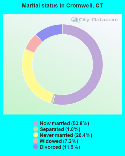
- Never married: 26.4%
- Now married: 53.8%
- Separated: 1.0%
- Widowed: 7.2%
- Divorced: 11.5%
For population 25 years and over in Cromwell:
- High school or higher: 87.0%
- Bachelor's degree or higher: 33.1%
- Graduate or professional degree: 13.3%
- Unemployed: 3.2%
- Mean travel time to work (commute): 21.2 minutes
| Here: | 11.3 |
| Connecticut average: | 12.8 |
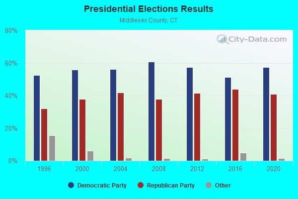
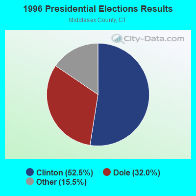
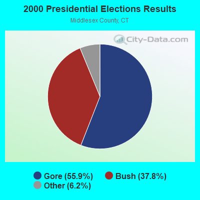
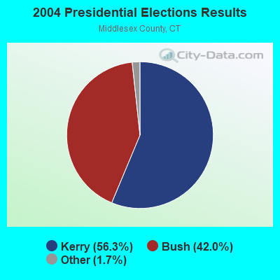
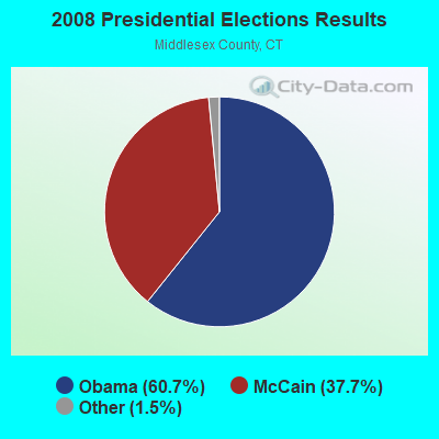
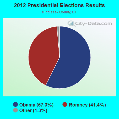
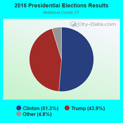

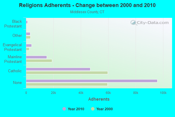
Graphs represent county-level data. Detailed 2008 Election Results
Religion statistics for Cromwell, CT (based on Middlesex County data)
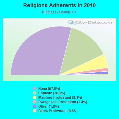
| Religion | Adherents | Congregations |
|---|---|---|
| Catholic | 46,800 | 18 |
| Mainline Protestant | 15,015 | 56 |
| Evangelical Protestant | 3,978 | 29 |
| Other | 2,921 | 11 |
| Black Protestant | 974 | 5 |
| Orthodox | 85 | 1 |
| None | 95,903 | - |
Food Environment Statistics:
| This county: | 1.71 / 10,000 pop. |
| Connecticut: | 2.21 / 10,000 pop. |
| Middlesex County: | 0.98 / 10,000 pop. |
| Connecticut: | 1.02 / 10,000 pop. |
| This county: | 2.56 / 10,000 pop. |
| Connecticut: | 2.27 / 10,000 pop. |
| Middlesex County: | 10.80 / 10,000 pop. |
| State: | 9.19 / 10,000 pop. |
| Middlesex County: | 7.0% |
| Connecticut: | 7.3% |
| Here: | 21.1% |
| Connecticut: | 21.5% |
| Middlesex County: | 13.6% |
| Connecticut: | 15.8% |
| Businesses in Cromwell, CT | ||||
| Name | Count | Name | Count | |
|---|---|---|---|---|
| AT&T | 1 | Lowe's | 1 | |
| Blockbuster | 1 | Marriott | 1 | |
| Burger King | 1 | McDonald's | 2 | |
| CVS | 1 | Nike | 1 | |
| Circle K | 1 | Payless | 1 | |
| Curves | 1 | RadioShack | 1 | |
| Dairy Queen | 1 | Ruby Tuesday | 1 | |
| Dunkin Donuts | 4 | Sears | 1 | |
| Fashion Bug | 1 | Stop & Shop | 1 | |
| FedEx | 2 | Super 8 | 1 | |
| Firestone Complete Auto Care | 1 | T-Mobile | 2 | |
| GNC | 1 | Taco Bell | 1 | |
| H&R Block | 1 | UPS | 3 | |
| Holiday Inn | 1 | Walgreens | 1 | |
| KFC | 1 | Walmart | 1 | |
| Kmart | 1 | Wendy's | 1 | |
Strongest AM radio stations in Cromwell:
- WTIC (1080 AM; 50 kW; HARTFORD, CT; Owner: INFINITY RADIO OPERATIONS INC.)
- WMRD (1150 AM; 2 kW; MIDDLETOWN, CT; Owner: CROSSROADS COMMUNICATIONS, INC.)
- WPOP (1410 AM; 5 kW; HARTFORD, CT; Owner: CAPSTAR TX LIMITED PARTNERSHIP)
- WLAT (910 AM; 5 kW; NEW BRITAIN, CT; Owner: MEGA COMMUNICATIONS OF NEW BRITAIN LICENSEE, LLC)
- WNNZ (640 AM; 50 kW; WESTFIELD, MA; Owner: CLEAR CHANNEL BROADCASTING LICENSES, INC.)
- WRYM (840 AM; 1 kW; NEW BRITAIN, CT)
- WMMW (1470 AM; 2 kW; MERIDEN, CT; Owner: BUCKLEY BROADCASTING CORP OF CT)
- WXCT (990 AM; 2 kW; SOUTHINGTON, CT; Owner: THE ADD RADIO GROUP, INC.)
- WDRC (1360 AM; 5 kW; HARTFORD, CT; Owner: BUCKLEY BROADCASTING CORPORATION)
- WCRN (830 AM; 50 kW; WORCESTER, MA; Owner: CARTER BROADCASTING CORPORATION)
- WALE (990 AM; 50 kW; GREENVILLE, RI; Owner: NORTH AMERICAN BROADCASTING CO., INC.)
- WFAN (660 AM; 50 kW; NEW YORK, NY; Owner: INFINITY BROADCASTING OPERATIONS, INC.)
- WVNE (760 AM; daytime; 25 kW; LEICESTER, MA; Owner: BLOUNT MASSCOM, INC.)
Strongest FM radio stations in Cromwell:
- WRCH (100.5 FM; NEW BRITAIN, CT; Owner: INFINITY RADIO OPERATIONS INC.)
- WKSS (95.7 FM; HARTFORD-MERIDEN, CT; Owner: CAPSTAR TX LIMITED PARTNERSHIP)
- WWYZ (92.5 FM; WATERBURY, CT; Owner: CAPSTAR TX LIMITED PARTNERSHIP)
- WZMX (93.7 FM; HARTFORD, CT; Owner: INFINITY RADIO OPERATIONS INC.)
- WHCN (105.9 FM; HARTFORD, CT; Owner: CAPSTAR TX LIMITED PARTNERSHIP)
- WMRQ (104.1 FM; WATERBURY, CT; Owner: CAPSTAR TX LIMITED PARTNERSHIP)
- WPKT (90.5 FM; MERIDEN, CT; Owner: CONNECTICUT PUBLIC BROADCASTING, INC)
- WDRC-FM (102.9 FM; HARTFORD, CT; Owner: BUCKLEY BROADCASTING CORPORATION)
- WTIC-FM (96.5 FM; HARTFORD, CT; Owner: INFINITY RADIO OPERATIONS INC.)
- WWUH (91.3 FM; WEST HARTFORD, CT; Owner: UNIVERSITY OF HARTFORD)
- WIHS (104.9 FM; MIDDLETOWN, CT; Owner: CONNECTICUT RADIO FELLOWSHIP, INC.)
- WKCI-FM (101.3 FM; HAMDEN, CT; Owner: CLEAR CHANNEL BROADCASTING LICENSES, INC.)
- WCCC-FM (106.9 FM; HARTFORD, CT; Owner: MARLIN BROADCASTING, LLC)
- W227AJ (93.3 FM; NORTHFORD, CT; Owner: SACRED HEART UNIVERSITY)
- WPLR (99.1 FM; NEW HAVEN, CT; Owner: COX RADIO, INC.)
- WJMJ (88.9 FM; HARTFORD, CT; Owner: ST. THOMAS SEMINARY)
- WILI-FM (98.3 FM; WILLIMANTIC, CT; Owner: NUTMEG BROADCASTING COMPANY)
- WAQY (102.1 FM; SPRINGFIELD, MA; Owner: SAGA COMMUNICATIONS OF NEW ENGLAND, LLC)
- WFCS (107.7 FM; NEW BRITAIN, CT; Owner: CENTRAL CONNECTICUT STATE UNIVERSITY)
- WHUS (91.7 FM; STORRS, CT; Owner: THE BD. OF TRUSTEES, THE UNIV. OF CT)
TV broadcast stations around Cromwell:
- WTIC-TV (Channel 61; HARTFORD, CT; Owner: TRIBUNE TELEVISION COMPANY)
- W11BJ (Channel 11; HARTFORD, CT; Owner: COMMUNICATIONS SITE MANAGEMENT LLC)
- WTXX (Channel 20; WATERBURY, CT; Owner: WTXX INC.)
- WVIT (Channel 30; NEW BRITAIN, CT; Owner: OUTLET BROADCASTING, INC)
- WEDH (Channel 24; HARTFORD, CT; Owner: CONNECTICUT PUBLIC BROADCASTING, INC.)
- WUVN (Channel 18; HARTFORD, CT; Owner: ENTRAVISION HOLDINGS, LLC)
- WFSB (Channel 3; HARTFORD, CT; Owner: MEREDITH CORPORATION)
- WTNH (Channel 8; NEW HAVEN, CT; Owner: WTNH BROADCASTING, INC.)
- WHTX-LP (Channel 10; HARTFORD, CT; Owner: ENTRAVISION HOLDINGS, LLC)
- WCTX (Channel 59; NEW HAVEN, CT; Owner: WTNH BROADCASTING, INC.)
- WEDY (Channel 65; NEW HAVEN, CT; Owner: CONNECTICUT PUBLIC BROADCASTING, INC.)
- WHPX (Channel 26; NEW LONDON, CT; Owner: PAXSON HARTFORD LICENSE, INC.)
- WRDM-LP (Channel 13; HARTFORD, CT; Owner: ZGS HARTFORD, INC.)
- WMLD-LP (Channel 6; HARTFORD, CT; Owner: HARVARD BROADCASTING, INC.)
- WHCT-LP (Channel 38; HARTFORD, CT; Owner: VENTURE TECHNOLOGIES GROUP, LLC)
- W51BZ (Channel 51; NEW HAVEN, CT; Owner: it COMMUNICATIONS, INC.)
- WYDN (Channel 48; WORCESTER, MA; Owner: EDUCATIONAL PUBLIC TV CORPORATION)
- WPXQ (Channel 69; BLOCK ISLAND, RI; Owner: OCEAN STATE TELEVISION, L.L.C.)
- WEDN (Channel 53; NORWICH, CT; Owner: CONNECTICUT PUBLIC BROADCASTING, INC.)
- WUTH-CA (Channel 47; HARTFORD, CT; Owner: ENTRAVISION HOLDINGS, LLC)
- National Bridge Inventory (NBI) Statistics
- 51Number of bridges
- 482ft / 147mTotal length
- $13,700,000Total costs
- 1,506,032Total average daily traffic
- 131,169Total average daily truck traffic
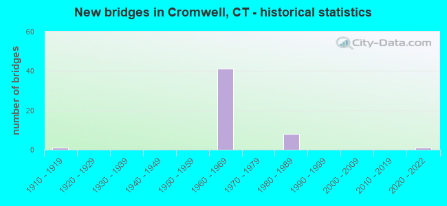
- New bridges - historical statistics
- 11910-1919
- 411960-1969
- 81980-1989
- 12020-2022
FCC Registered Antenna Towers:
19 (See the full list of FCC Registered Antenna Towers in Cromwell)FCC Registered Private Land Mobile Towers:
1 (See the full list of FCC Registered Private Land Mobile Towers in Cromwell, CT)FCC Registered Broadcast Land Mobile Towers:
22 (See the full list of FCC Registered Broadcast Land Mobile Towers)FCC Registered Microwave Towers:
4- 252 Shunpike Road (Lat: 41.633417 Lon: -72.672861), Overall height: 33.5 m, Call Sign: WPJF242,
Assigned Frequencies: 10955.0 MHz, Grant Date: 04/14/2021, Expiration Date: 04/30/2031, Registrant: Fcc-Faa Licensing, LLC, 8932 Suite D Milford Haven Court, Lorton, VA 22079, Phone: (703) 615-6615, Email:
- CT-HFD0132A, 201 Main St (Lat: 41.583417 Lon: -72.649806), Type: Pole, Structure height: 38.1 m, Overall height: 40.8 m, Call Sign: WQMQ219,
Assigned Frequencies: 10735.0 MHz, 19375.0 MHz, 10815.0 MHz, 19475.0 MHz, Grant Date: 11/03/2020, Expiration Date: 10/19/2030, Cancellation Date: 09/14/2021, Certifier: Nadja S Sodos-Wallace, Registrant: T-Mobile Usa, Inc., 12920 Se 38th Street, Bellevue, WA 98006, Phone: (425) 383-8402, Fax: (425) 383-4840, Email:
- CT-HFD0125B, 179 Shunpike Rd (Lat: 41.623139 Lon: -72.679111), Type: Tower, Structure height: 51.8 m, Call Sign: WQMQ277,
Assigned Frequencies: 11225.0 MHz, 11265.0 MHz, 11305.0 MHz, 11305.0 MHz, 11345.0 MHz, 11385.0 MHz, Grant Date: 11/03/2020, Expiration Date: 10/20/2030, Cancellation Date: 09/14/2021, Certifier: Nadja S Sodos-Wallace, Registrant: T-Mobile Usa, Inc., 12920 Se 38th Street, Bellevue, WA 98006, Phone: (425) 383-8402, Fax: (425) 383-4840, Email:
- SHUNPIKEROAD, 179 Shunpike Rd (Lat: 41.623250 Lon: -72.679056), Type: Ltower, Structure height: 51.8 m, Overall height: 56.4 m, Call Sign: WQZR484,
Assigned Frequencies: 11565.0 MHz, 11445.0 MHz, 11565.0 MHz, 11445.0 MHz, 11565.0 MHz, 11445.0 MHz, 11565.0 MHz, 11445.0 MHz, Grant Date: 07/14/2017, Expiration Date: 07/14/2027, Certifier: Wayne A Bartolotta, Registrant: Utility Communications Inc, 920 Sherman Ave, Hamden, CT 06514, Phone: (203) 287-1306, Fax: (203) 248-9167, Email:
FCC Registered Paging Towers:
1- 140 Berlin Road (Lat: 41.607028 Lon: -72.711194), Call Sign: KQZ747,
Assigned Frequencies: 158.700 MHz, Grant Date: 04/27/1999, Expiration Date: 04/01/2009, Cancellation Date: 03/09/2009, Certifier: John T Scott Iii, Registrant: American Messaging Services, LLC, 1720 Lakepointe Drive, #100, Lewisville, TX 75057, Phone: (214) 222-6460, Fax: (972) 353-1912, Email:
FCC Registered Amateur Radio Licenses:
60 (See the full list of FCC Registered Amateur Radio Licenses in Cromwell)FAA Registered Aircraft:
7- Aircraft: GAUTHIER JOSEPH J E CW-SPCL (Category: Land, Seats: 2, Weight: Up to 12,499 Pounds), Engine: LYCOMING 0-320 SERIES (180 HP) (Reciprocating)
N-Number: 22607, N22607, N-22607, Serial Number: 001, Year manufactured: 1995, Airworthiness Date: 03/02/2001, Certificate Issue Date: 09/28/1994
Registrant (Individual): Joseph J E Gauthier, 9 Kowal Dr, Cromwell, CT 06416 - Aircraft: RV AVIATION CT LLC VANS RV6A (Category: Land, Seats: 2, Weight: Up to 12,499 Pounds), Engine: MATTITUCK TMX 360 (180 HP) (Reciprocating)
N-Number: 3158Y, N3158Y, N-3158Y, Serial Number: 25331, Year manufactured: 2008, Airworthiness Date: 10/18/2008, Certificate Issue Date: 05/18/2007
Registrant (LLC): Rv Aviation Ct LLC, 9 Kowal Dr, Cromwell, CT 06416 - Aircraft: CESSNA 172P (Category: Land, Seats: 4, Weight: Up to 12,499 Pounds), Engine: LYCOMING 0-320 SERIES (180 HP) (Reciprocating)
N-Number: 63512, N63512, N-63512, Serial Number: 17275447, Year manufactured: 1981, Airworthiness Date: 11/18/1981, Certificate Issue Date: 11/17/1999
Registrant (Individual): Joseph E Corlis, 17 Redwood Ct, Cromwell, CT 06416 - Aircraft: PIPER PA-28-180 (Category: Land, Seats: 4, Weight: Up to 12,499 Pounds, Speed: 107 mph), Engine: LYCOMING O&VO-360 SER (180 HP) (Reciprocating)
N-Number: 6512J, N6512J, N-6512J, Serial Number: 28-4949, Year manufactured: 1968, Airworthiness Date: 05/14/1968, Certificate Issue Date: 05/02/2001
Registrant (Individual): Nelson Dion, 64 Nooks Hill Rd, Cromwell, CT 06416 - Aircraft: HAWKER BEECHCRAFT CORP G36 (Category: Land, Seats: 6, Weight: Up to 12,499 Pounds), Engine: CONT MOTOR IO-550-B (300 HP) (Reciprocating)
N-Number: 771WG, N771WG, N-771WG, Serial Number: E-3835, Year manufactured: 2008, Airworthiness Date: 07/03/2008, Certificate Issue Date: 11/10/2010
Registrant (Individual): William J Greco, 12 Lower Heatherwood, Cromwell, CT 06416 - Aircraft: CESSNA 172 (Category: Land, Seats: 4, Weight: Up to 12,499 Pounds, Speed: 105 mph), Engine: CONT MOTOR 0-300 SER (145 HP) (Reciprocating)
N-Number: 8142B, N8142B, N-8142B, Serial Number: 29942, Year manufactured: 1957, Airworthiness Date: 06/07/1957, Certificate Issue Date: 02/27/1987
Registrant (Individual): Ronald E Jones, 5 Highridge Rd, Cromwell, CT 06416 - Aircraft: CESSNA 421C (Category: Land, Engines: 2, Seats: 8, Weight: Up to 12,499 Pounds, Speed: 90 mph), Engine: CONT MOTOR GTSI0-520-F-K (435 HP) (Reciprocating)
N-Number: 84HA, N84HA, N-84HA, Serial Number: 421C-1407, Year manufactured: 1984, Airworthiness Date: 07/12/1984, Certificate Issue Date: 10/05/2017
Registrant (LLC): Wheels Up LLC, 162 West St Ste A, Cromwell, CT 06416
2002 - 2018 National Fire Incident Reporting System (NFIRS) incidents
- Fire incident types reported to NFIRS in Cromwell, CT
- 32034.7%Structure Fires
- 28530.9%Outside Fires
- 23725.7%Mobile Property/Vehicle Fires
- 818.8%Other
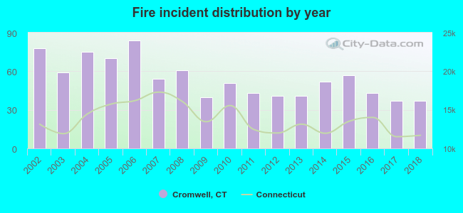 According to the data from the years 2002 - 2018 the average number of fire incidents per year is 54. The highest number of fire incidents - 84 took place in 2006, and the least - 37 in 2017. The data has a decreasing trend.
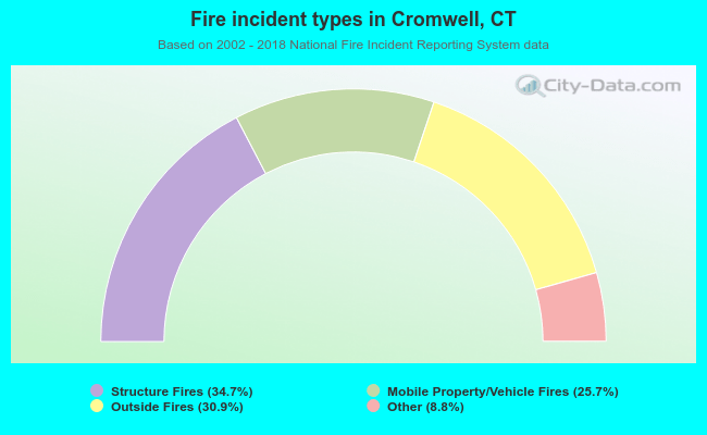 When looking into fire subcategories, the most incidents belonged to: Structure Fires (34.7%), and Outside Fires (30.9%).
Fire-safe hotels and motels in Cromwell, Connecticut:
- Red Lion Hotel Cromwell, 100 Berlin Rd, Cromwell, Connecticut 06416 , Phone: (860) 288-4985, Fax: (860) 635-6970
- Comfort Inn, 111 Berlin Rd, Cromwell, Connecticut 06416 , Phone: (860) 635-4100, Fax: (860) 632-9546
- Red Lion Hotel Cromwell, 100 Berlin Rd, Cromwell, Connecticut 06416 , Phone: (860) 635-2000
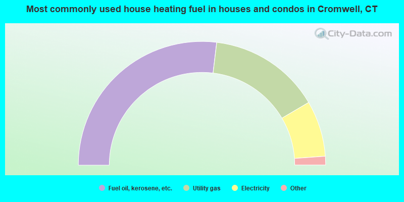
- 53.8%Fuel oil, kerosene, etc.
- 29.3%Utility gas
- 14.6%Electricity
- 0.9%Bottled, tank, or LP gas
- 0.8%Other fuel
- 0.5%Wood
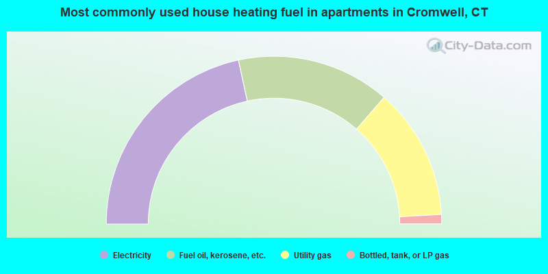
- 43.2%Electricity
- 29.6%Fuel oil, kerosene, etc.
- 25.4%Utility gas
- 1.8%Bottled, tank, or LP gas
Cromwell compared to Connecticut state average:
- Unemployed percentage significantly below state average.
- Black race population percentage below state average.
- Hispanic race population percentage significantly below state average.
- Foreign-born population percentage below state average.
- Renting percentage below state average.
- Length of stay since moving in significantly above state average.
- Number of rooms per house significantly below state average.
- House age significantly below state average.
Cromwell on our top lists:
- #24 on the list of "Top 101 cities with largest percentage of males in industries: fuel dealers (population 5,000+)"
- #30 on the list of "Top 101 cities with largest percentage of males in occupations: financial managers (population 5,000+)"
- #32 on the list of "Top 101 cities with largest percentage of males in occupations: other healthcare support occupations (population 5,000+)"
- #36 on the list of "Top 101 cities with largest percentage of males in industries: food and beverage stores (population 5,000+)"
- #38 on the list of "Top 101 cities with largest percentage of females in industries: fuel dealers (population 5,000+)"
- #39 on the list of "Top 101 cities with largest percentage of females in industries: radio, tv, and computer stores (population 5,000+)"
- #40 on the list of "Top 101 cities with largest percentage of females in occupations: accountants and auditors (population 5,000+)"
- #41 on the list of "Top 101 cities with largest percentage of males in occupations: bookkeeping, accounting, and auditing clerks (population 5,000+)"
- #47 on the list of "Top 101 cities with the largest percentage of people in homes for abused, dependent, and neglected children (population 1,000+)"
- #56 on the list of "Top 101 cities with largest percentage of males in occupations: food and beverage serving workers except waiters/waitresses (population 5,000+)"
- #67 on the list of "Top 101 cities with largest percentage of females in occupations: electricians (population 5,000+)"
- #90 on the list of "Top 101 cities with largest percentage of males in industries: pharmacies and drug stores (population 5,000+)"
- #4 on the list of "Top 101 counties with the highest percentage of residents that visited a dentist within the past year"
- #11 on the list of "Top 101 counties with the best general health status score of residents (1-5), 3 years of data"
- #17 on the list of "Top 101 counties with the lowest number of births per 1000 residents 2007-2013"
- #25 on the list of "Top 101 counties with the highest average weight of females"
- #32 on the list of "Top 101 counties with the largest decrease in the number of births per 1000 residents 2000-2006 to 2007-2013 (pop 50,000+)"

|
|
Total of 280 patent applications in 2008-2024.