Middlefield, Connecticut


Submit your own pictures of this town and show them to the world
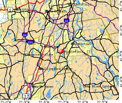
- OSM Map
- General Map
- Google Map
- MSN Map
Population change since 2000: +5.3%
 |
| Males: 2,228 | |
| Females: 2,197 |
| Median resident age: | 44.7 years |
| Connecticut median age: | 39.2 years |
Zip codes: 06455.
| Middlefield: | $97,468 |
| CT: | $88,429 |
Estimated per capita income in 2022: $46,103 (it was $25,711 in 2000)
Middlefield town income, earnings, and wages data
Estimated median house or condo value in 2022: $353,469 (it was $163,500 in 2000)
| Middlefield: | $353,469 |
| CT: | $347,200 |
Mean prices in 2022: all housing units: $381,367; detached houses: $403,130; townhouses or other attached units: $256,262; in 2-unit structures: $274,238; in 3-to-4-unit structures: $246,924; in 5-or-more-unit structures: $191,256; mobile homes: $82,291
Detailed information about poverty and poor residents in Middlefield, CT
Compare current foreclosures near Middlefield, CT:
| Photo | Address | Area | Beds / Baths | Price | Details |
|---|---|---|---|---|---|

|
#1
Main St
Middlefield, CT 06455
|
1,526 sq. feet
|
2 baths 3 beds |
show details | |

|
#2
Seminole Rd
Middlefield, CT 06455
|
576 sq. feet
|
2 baths 2 beds |
show details | |

|
#3
Strong St
New Haven, CT 06512
|
1,122 sq. feet
|
1 baths 3 beds |
$171,600
|
show details |

|
#4
Peck St
Berlin, CT 06037
|
608 sq. feet
|
1 baths 1 beds |
$144,900
|
show details |

|
#5
Roosevelt St
New Britain, CT 06051
|
1,536 sq. feet
|
2 baths 3 beds |
$299,900
|
show details |

|
#6
Royal Oak Lane
Wallingford, CT 06492
|
2,607 sq. feet
|
2 baths 4 beds |
$684,900
|
show details |

|
#7
Spring St
Glastonbury, CT 06033
|
1,284 sq. feet
|
1 baths 3 beds |
$296,400
|
show details |

|
#8
Fairview Ave # U-2
Hamden, CT 06514
|
1,284 sq. feet
|
1 baths 3 beds |
$174,000
|
show details |

|
#9
Railroad Ave
Chester, CT 06412
|
2,092 sq. feet
|
2 baths 4 beds |
$499,900
|
show details |

|
#10
Beechwood Rd
Branford, CT 06405
|
2,204 sq. feet
|
2 baths 4 beds |
$723,500
|
show details |
| Photo | Address | Area | Beds / Baths | Price | Details |
|---|---|---|---|---|---|

|
#11
Bronson Ave
Meriden, CT 06451
|
1,150 sq. feet
|
1 baths 3 beds |
$299,900
|
show details |

|
#12
Branford Rd Unit 150
North Branford, CT 06471
|
851 sq. feet
|
1 baths 2 beds |
$234,900
|
show details |

|
#13
Birchwood Dr
Hamden, CT 06518
|
2,604 sq. feet
|
2 baths 3 beds |
$655,000
|
show details |

|
#14
Willis Ave
Meriden, CT 06450
|
1,008 sq. feet
|
1 baths 2 beds |
$299,900
|
show details |

|
#15
Westchester Rd
Colchester, CT 06415
|
900 sq. feet
|
1 baths 2 beds |
$309,900
|
show details |

|
#16
Sylvan Ave
Waterbury, CT 06706
|
1,350 sq. feet
|
1 baths 4 beds |
show details | |

|
#17
Reskin Dr
Wallingford, CT 06492
|
2,303 sq. feet
|
1 baths 4 beds |
show details | |

|
#18
Main St
Meriden, CT 06451
|
1,008 sq. feet
|
1 baths 3 beds |
show details | |

|
#19
Hollister Dr
East Hartford, CT 06118
|
1,300 sq. feet
|
1 baths 3 beds |
show details | |

|
#20
Melinda Ln
Bristol, CT 06010
|
- sq. feet
|
2 baths 4 beds |
show details |
| Photo | Address | Area | Beds / Baths | Price | Details |
|---|---|---|---|---|---|

|
#21
Ferncrest Dr
East Hartford, CT 06118
|
1,890 sq. feet
|
3 baths 4 beds |
show details | |

|
#22
Fawn Meadow Dr
Naugatuck, CT 06770
|
3,052 sq. feet
|
3 baths 4 beds |
show details | |

|
#23
Old Fairwood Rd
Bethany, CT 06524
|
2,464 sq. feet
|
3 baths 4 beds |
show details | |

|
#24
Mohawk Dr
Wallingford, CT 06492
|
1,524 sq. feet
|
3 baths 4 beds |
show details | |

|
#25
Amity St
Meriden, CT 06450
|
1,568 sq. feet
|
2 baths 3 beds |
show details | |

|
#26
Park Rd
Marlborough, CT 06447
|
1,134 sq. feet
|
1 baths 3 beds |
show details | |

|
#27
Butternut Ln
Rocky Hill, CT 06067
|
1,176 sq. feet
|
1 baths 2 beds |
show details | |

|
#28
Farmington Chase Cre
Farmington, CT 06032
|
1,317 sq. feet
|
1 baths 2 beds |
show details | |

|
#29
Ranslow Dr
Wolcott, CT 06716
|
1,908 sq. feet
|
2 baths 4 beds |
show details | |

|
#30
Tom Swamp Rd
Hamden, CT 06518
|
2,008 sq. feet
|
2 baths 3 beds |
show details |
| Photo | Address | Area | Beds / Baths | Price | Details |
|---|---|---|---|---|---|

|
#31
Horne Cir
Southington, CT 06489
|
1,902 sq. feet
|
2 baths 4 beds |
show details | |

|
#32
Main St
Newington, CT 06111
|
1,512 sq. feet
|
1 baths 4 beds |
show details | |

|
#33
City Ave
New Britain, CT 06051
|
1,932 sq. feet
|
1 baths 3 beds |
show details | |

|
#34
Feather Ln
North Branford, CT 06471
|
4,408 sq. feet
|
2 baths 4 beds |
show details | |

|
#35
Churchill Dr
Newington, CT 06111
|
1,116 sq. feet
|
1 baths 2 beds |
show details | |

|
#36
Benham St
Bristol, CT 06010
|
974 sq. feet
|
1 baths 3 beds |
show details | |

|
#37
Windsor Rd
Hamden, CT 06517
|
1,116 sq. feet
|
3 baths 4 beds |
show details | |

|
#38
21 Webster St
New Britain, CT 06051
|
3 sq. feet
|
2 baths 6 beds |
show details | |

|
#39
Stanley St
New Britain, CT 06051
|
- sq. feet
|
3 baths 6 beds |
show details | |

|
#40
Dover Rd
New Britain, CT 06052
|
2,212 sq. feet
|
2 baths 3 beds |
show details |
| Photo | Address | Area | Beds / Baths | Price | Details |
|---|---|---|---|---|---|

|
#41
Pond St
New Britain, CT 06051
|
2,400 sq. feet
|
2 baths 6 beds |
show details | |

|
#42
Cheshire St
Hartford, CT 06114
|
3,279 sq. feet
|
2 baths 4 beds |
show details | |

|
#43
Broadview Ter
Hartford, CT 06106
|
1,821 sq. feet
|
2 baths 7 beds |
show details | |

|
#44
Avery Ave
Meriden, CT 06450
|
1,508 sq. feet
|
1 baths 3 beds |
show details | |

|
#45
Pratt St
Meriden, CT 06450
|
1,040 sq. feet
|
2 baths 3 beds |
show details | |

|
#46
Hillfield Rd
Hamden, CT 06518
|
2,130 sq. feet
|
3 baths 3 beds |
show details | |

|
#47
Lydale Pl
Meriden, CT 06450
|
1,716 sq. feet
|
2 baths 3 beds |
show details | |

|
#48
Obrien Dr
Meriden, CT 06450
|
1,612 sq. feet
|
2 baths 2 beds |
show details | |

|
#49
Whiting St
Hamden, CT 06514
|
1,508 sq. feet
|
2 baths 4 beds |
show details | |

|
Check over 1 million property listings on Foreclosure.com!
|
browse all offers | |||

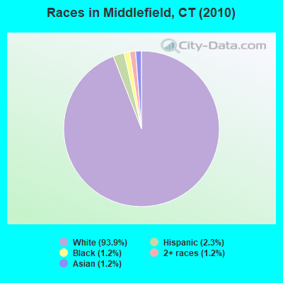
- 4,15793.9%White alone
- 1032.3%Hispanic
- 551.2%Black alone
- 511.2%Asian alone
- 531.2%Two or more races
- 30.07%American Indian alone
- 30.07%Other race alone
Races in Middlefield detailed stats: ancestries, foreign born residents, place of birth
According to our research of Connecticut and other state lists, there were 3 registered sex offenders living in Middlefield, Connecticut as of April 29, 2024.
The ratio of all residents to sex offenders in Middlefield is 1,475 to 1.
The ratio of registered sex offenders to all residents in this city is lower than the state average.
 Recent articles from our blog. Our writers, many of them Ph.D. graduates or candidates, create easy-to-read articles on a wide variety of topics.

 | 2024 Connecticut Town Tournament VI (Celebrating the 10-Year Anniversary & Dazzleman's Memorial) (746 replies) |
| Connecticut TOWN TOURNAMENT V (2022) (831 replies) |
| Seattle to Hartford or New Haven (142 replies) |
| Commutable to Wallingford (25 replies) |
| African American Woman - Hebron, Connecticut - (9 replies) |
| Connecticut Weather Discussion (9637 replies) |
Latest news from Middlefield, CT collected exclusively by city-data.com from local newspapers, TV, and radio stations
Middlefield, CT City Guides:
Ancestries: Italian (26.1%), Irish (22.8%), Polish (21.2%), English (13.6%), German (13.5%), French (6.6%).
Current Local Time: EST time zone
Incorporated on 06/1866
Elevation: 163 feet
Land area: 12.7 square miles.
Population density: 348 people per square mile (very low).
96 residents are foreign born (1.5% Europe, 0.3% Latin America, 0.3% Asia, 0.2% North America).
| This town: | 2.3% |
| Connecticut: | 10.9% |
| Middlefield town: | 1.8% ($3,006) |
| Connecticut: | 1.8% ($2,961) |
Nearest city with pop. 50,000+: Meriden, CT  (4.7 miles , pop. 58,244).
Nearest city with pop. 200,000+: North Hempstead, NY (71.4 miles , pop. 222,611).
Nearest city with pop. 1,000,000+: Bronx, NY (76.2 miles , pop. 1,332,650).
Nearest cities:
), ), Latitude: 41.52 N, Longitude: 72.71 W

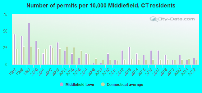
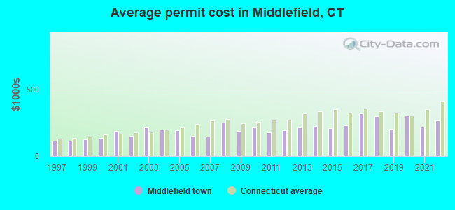
Single-family new house construction building permits:
- 2022: 4 buildings, average cost: $269,800
- 2021: 3 buildings, average cost: $222,300
- 2020: 6 buildings, average cost: $303,700
- 2019: 3 buildings, average cost: $206,700
- 2018: 6 buildings, average cost: $297,700
- 2017: 9 buildings, average cost: $322,100
- 2016: 9 buildings, average cost: $232,900
- 2015: 6 buildings, average cost: $207,800
- 2014: 7 buildings, average cost: $225,200
- 2013: 11 buildings, average cost: $216,600
- 2012: 9 buildings, average cost: $194,600
- 2011: 3 buildings, average cost: $177,100
- 2010: 7 buildings, average cost: $217,500
- 2009: 1 building, cost: $191,400
- 2008: 1 building, cost: $250,000
- 2007: 7 buildings, average cost: $145,400
- 2006: 4 buildings, average cost: $151,600
- 2005: 7 buildings, average cost: $196,000
- 2004: 9 buildings, average cost: $202,100
- 2003: 14 buildings, average cost: $214,400
- 2002: 12 buildings, average cost: $151,600
- 2001: 7 buildings, average cost: $187,000
- 2000: 15 buildings, average cost: $139,300
- 1999: 26 buildings, average cost: $127,600
- 1998: 18 buildings, average cost: $116,200
- 1997: 19 buildings, average cost: $116,700
| Here: | 2.9% |
| Connecticut: | 3.9% |
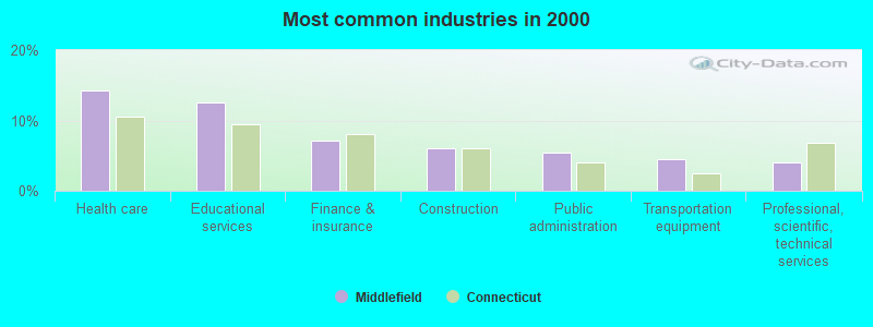
- Health care (14.2%)
- Educational services (12.6%)
- Finance & insurance (7.1%)
- Construction (6.0%)
- Public administration (5.4%)
- Transportation equipment (4.5%)
- Professional, scientific, technical services (4.1%)
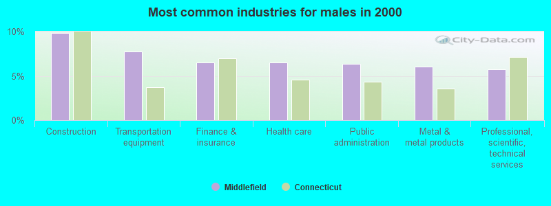
- Construction (9.9%)
- Transportation equipment (7.8%)
- Finance & insurance (6.5%)
- Health care (6.5%)
- Public administration (6.3%)
- Metal & metal products (6.1%)
- Professional, scientific, technical services (5.7%)
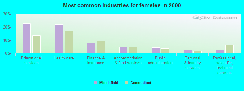
- Educational services (22.7%)
- Health care (22.0%)
- Finance & insurance (7.7%)
- Accommodation & food services (4.5%)
- Public administration (4.5%)
- Personal & laundry services (2.5%)
- Professional, scientific, technical services (2.5%)
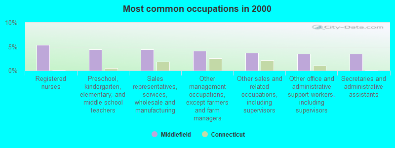
- Registered nurses (5.4%)
- Preschool, kindergarten, elementary, and middle school teachers (4.4%)
- Sales representatives, services, wholesale and manufacturing (4.4%)
- Other management occupations, except farmers and farm managers (4.1%)
- Other sales and related occupations, including supervisors (3.7%)
- Other office and administrative support workers, including supervisors (3.5%)
- Secretaries and administrative assistants (3.5%)
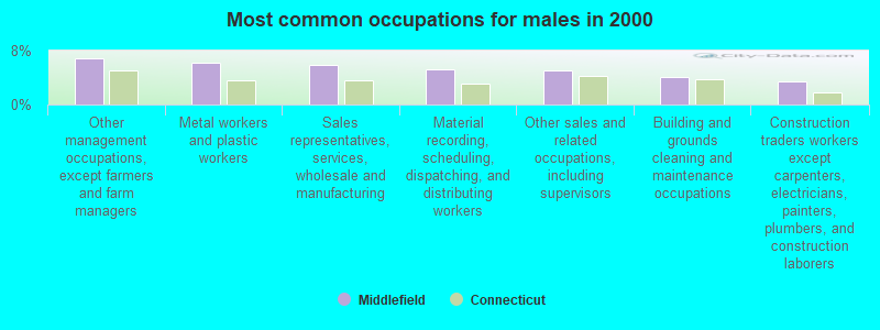
- Other management occupations, except farmers and farm managers (6.8%)
- Metal workers and plastic workers (6.2%)
- Sales representatives, services, wholesale and manufacturing (5.8%)
- Material recording, scheduling, dispatching, and distributing workers (5.3%)
- Other sales and related occupations, including supervisors (5.1%)
- Building and grounds cleaning and maintenance occupations (4.1%)
- Construction traders workers except carpenters, electricians, painters, plumbers, and construction laborers (3.4%)
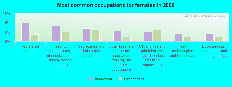
- Registered nurses (10.1%)
- Preschool, kindergarten, elementary, and middle school teachers (8.2%)
- Secretaries and administrative assistants (7.0%)
- Other teachers, instructors, education, training, and library occupations (5.7%)
- Other office and administrative support workers, including supervisors (5.2%)
- Health technologists and technicians (4.1%)
- Bookkeeping, accounting, and auditing clerks (4.0%)
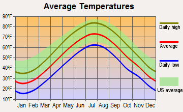
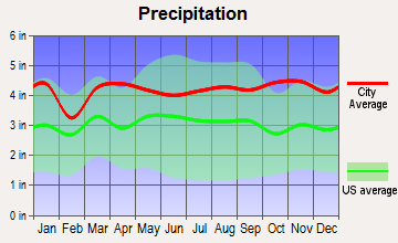
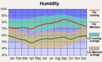
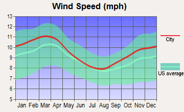
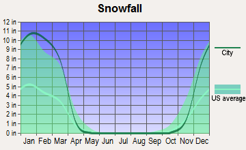
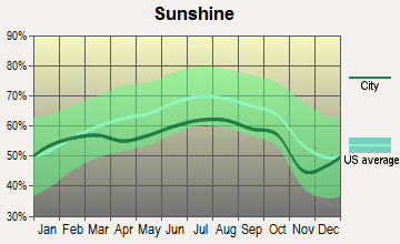
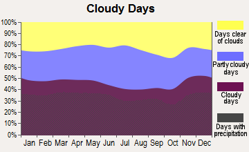
Average climate in Middlefield, Connecticut
Based on data reported by over 4,000 weather stations
(lower is better)
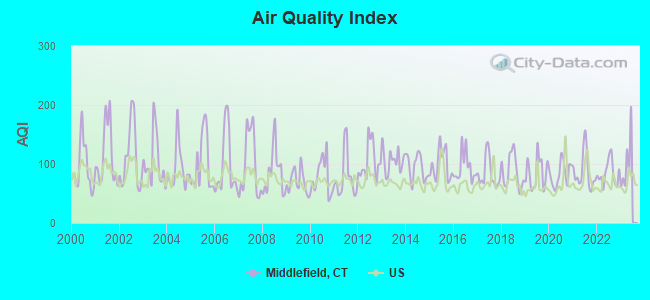
Air Quality Index (AQI) level in 2022 was 84.5. This is about average.
| City: | 84.5 |
| U.S.: | 72.6 |
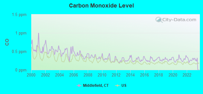
Carbon Monoxide (CO) [ppm] level in 2022 was 0.275. This is about average. Closest monitor was 11.1 miles away from the city center.
| City: | 0.275 |
| U.S.: | 0.251 |
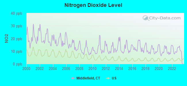
Nitrogen Dioxide (NO2) [ppb] level in 2022 was 11.0. This is significantly worse than average. Closest monitor was 4.5 miles away from the city center.
| City: | 11.0 |
| U.S.: | 5.1 |
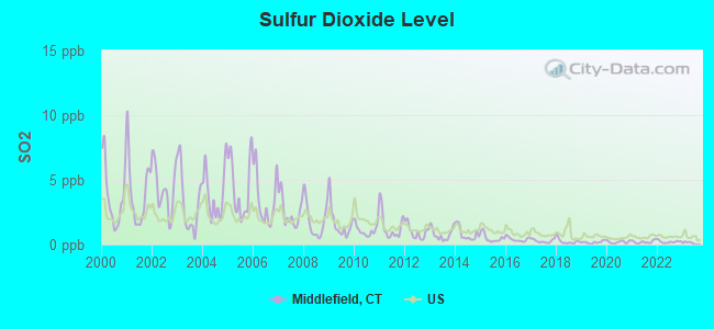
Sulfur Dioxide (SO2) [ppb] level in 2022 was 0.214. This is significantly better than average. Closest monitor was 4.5 miles away from the city center.
| City: | 0.214 |
| U.S.: | 1.515 |
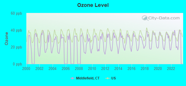
Ozone [ppb] level in 2022 was 28.9. This is about average. Closest monitor was 4.5 miles away from the city center.
| City: | 28.9 |
| U.S.: | 33.3 |
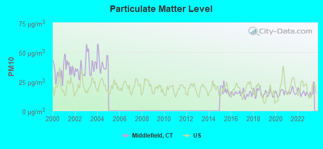
Particulate Matter (PM10) [µg/m3] level in 2022 was 15.2. This is better than average. Closest monitor was 7.2 miles away from the city center.
| City: | 15.2 |
| U.S.: | 19.2 |
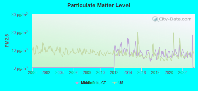
Particulate Matter (PM2.5) [µg/m3] level in 2022 was 7.47. This is about average. Closest monitor was 16.1 miles away from the city center.
| City: | 7.47 |
| U.S.: | 8.11 |
Tornado activity:
Middlefield-area historical tornado activity is near Connecticut state average. It is 30% smaller than the overall U.S. average.
On 7/10/1989, a category F4 (max. wind speeds 207-260 mph) tornado 13.6 miles away from the Middlefield town center injured 40 people and caused between $50,000,000 and $500,000,000 in damages.
On 10/3/1979, a category F4 tornado 25.2 miles away from the town center killed 3 people and injured 500 people and caused between $50,000,000 and $500,000,000 in damages.
Earthquake activity:
Middlefield-area historical earthquake activity is significantly above Connecticut state average. It is 71% smaller than the overall U.S. average.On 10/7/1983 at 10:18:46, a magnitude 5.3 (5.1 MB, 5.3 LG, 5.1 ML, Class: Moderate, Intensity: VI - VII) earthquake occurred 187.7 miles away from Middlefield center
On 4/20/2002 at 10:50:47, a magnitude 5.3 (5.3 ML, Depth: 3.0 mi) earthquake occurred 213.1 miles away from the city center
On 4/20/2002 at 10:50:47, a magnitude 5.2 (5.2 MB, 4.2 MS, 5.2 MW, 5.0 MW) earthquake occurred 211.6 miles away from Middlefield center
On 1/19/1982 at 00:14:42, a magnitude 4.7 (4.5 MB, 4.7 MD, 4.5 LG, Class: Light, Intensity: IV - V) earthquake occurred 148.4 miles away from Middlefield center
On 8/23/2011 at 17:51:04, a magnitude 5.8 (5.8 MW, Depth: 3.7 mi) earthquake occurred 373.4 miles away from Middlefield center
On 10/16/2012 at 23:12:25, a magnitude 4.7 (4.7 ML, Depth: 10.0 mi) earthquake occurred 178.0 miles away from the city center
Magnitude types: regional Lg-wave magnitude (LG), body-wave magnitude (MB), duration magnitude (MD), local magnitude (ML), surface-wave magnitude (MS), moment magnitude (MW)
Natural disasters:
The number of natural disasters in Middlesex County (21) is greater than the US average (15).Major Disasters (Presidential) Declared: 12
Emergencies Declared: 9
Causes of natural disasters: Hurricanes: 6, Storms: 6, Floods: 5, Blizzards: 3, Snowstorms: 3, Winter Storms: 3, Snow: 1, Snowfall: 1, Tropical Storm: 1, Wind: 1 (Note: some incidents may be assigned to more than one category).
Main business address for: ZYGO CORP (OPTICAL INSTRUMENTS & LENSES).
Hospitals and medical centers near Middlefield:
- APPLE REHAB COCCOMO (Nursing Home, about 3 miles away; MERIDEN, CT)
- CONNECTICUT BAPTIST HOMES, INC (Nursing Home, about 3 miles away; MERIDEN, CT)
- CENTRAL CT DIALYSIS CENTER (Dialysis Facility, about 3 miles away; MERIDEN, CT)
- DOGWOOD ACRES (Nursing Home, about 3 miles away; DURHAM, CT)
- WADSWORTH GLEN HEALTH CARE CEN (Nursing Home, about 4 miles away; MIDDLETOWN, CT)
- APPLE REHAB MIDDLETOWN (Nursing Home, about 4 miles away; MIDDLETOWN, CT)
- MERIDEN CENTER (Nursing Home, about 4 miles away; MERIDEN, CT)
Amtrak stations near Middlefield:
- 5 miles: MERIDEN (60 STATE ST.) . Services: ticket office, partially wheelchair accessible, enclosed waiting area, public restrooms, public payphones, vending machines, call for car rental service, call for taxi service, public transit connection.
- 8 miles: WALLINGFORD (37 HALL AVE.) . Services: partially wheelchair accessible, enclosed waiting area, public payphones, free short-term parking, call for car rental service, call for taxi service.
- 9 miles: BERLIN (KENSINGTON, DEPOT RD.) . Services: ticket office, partially wheelchair accessible, enclosed waiting area, public restrooms, public payphones, free short-term parking, free long-term parking, call for car rental service, call for taxi service, public transit connection.
Colleges/universities with over 2000 students nearest to Middlefield:
- Wesleyan University (about 4 miles; Middletown, CT; Full-time enrollment: 3,517)
- Quinnipiac University (about 12 miles; Hamden, CT; FT enrollment: 8,153)
- Central Connecticut State University (about 13 miles; New Britain, CT; FT enrollment: 9,989)
- Tunxis Community College (about 16 miles; Farmington, CT; FT enrollment: 2,787)
- Trinity College (about 16 miles; Hartford, CT; FT enrollment: 2,355)
- Goodwin College (about 17 miles; East Hartford, CT; FT enrollment: 3,017)
- University of Connecticut-Tri-Campus (about 18 miles; Waterbury, CT; FT enrollment: 2,250)
Public elementary/middle schools in Middlefield:
- JOHN LYMAN SCHOOL (Students: 411, Location: 106 WAY ROAD, Grades: PK-4)
- MIDDLEFIELD MEMORIAL SCHOOL (Students: 351, Location: 124 HUBBARD STREET, Grades: 5-6)
Private elementary/middle school in Middlefield:
Points of interest:
Notable locations in Middlefield: Lyman Meadow Golf Club (A), Rockfall (B), Indian Springs Golf Club (C), Middlefield Volunteer Fire Company (D), Middlefield Town Hall (E), Levi E Coe Library (F). Display/hide their locations on the map
Main business address in Middlefield: ZYGO CORP (A). Display/hide its location on the map
Churches in Middlefield include: Middlefield Federated Church (A), Saint Colman Church (B), Victory Tabernacle Church (C). Display/hide their locations on the map
Cemeteries: Saint Sebastian Cemetery (1), North Cemetery (2). Display/hide their locations on the map
Reservoirs: Laurel Brook Reservoir (A), Beseck Lake (B), Black Pond (C), Mount Higby Reservoir (D). Display/hide their locations on the map
Streams, rivers, and creeks: Lyman Meadow Brook (A), Sawmill Brook (B), Wadsworth Brook (C), Hans Brook (D). Display/hide their locations on the map
Parks in Middlefield include: Black Pond State Wildlife Area (1), Wadsworth Falls State Park (2), Durham Meadows State Wildlife Area (3), Cockaponset State Forest (4), Durman Meadows State Wildlife Area (5). Display/hide their locations on the map
Birthplace of: William Lyman (inventor) - Inventor.
Drinking water stations with addresses in Middlefield and their reported violations in the past:
OLD INDIAN TRAIL (Population served: 32, Groundwater):Past monitoring violations:
- 7 regular monitoring violations
Drinking water stations with addresses in Middlefield that have no violations reported:
- BITTERSWEET RIDGE WATER ASSOCIATION (Population served: 40, Primary Water Source Type: Groundwater)
| This town: | 2.5 people |
| Connecticut: | 2.5 people |
| This town: | 71.9% |
| Whole state: | 66.3% |
| This town: | 6.4% |
| Whole state: | 6.6% |
Likely homosexual households (counted as self-reported same-sex unmarried-partner households)
- Lesbian couples: 0.5% of all households
- Gay men: 0.2% of all households
| This town: | 1.5% |
| Whole state: | 7.9% |
| This town: | 1.2% |
| Whole state: | 3.9% |
Banks with branches in Middlefield (2011 data):
- Liberty Bank: Middlefield Branch at 486 Main Street, branch established on 1974/12/07. Info updated 2011/01/06: Bank assets: $3,394.1 mil, Deposits: $2,747.0 mil, headquarters in Middletown, CT, positive income, Commercial Lending Specialization, 43 total offices
For population 15 years and over in Middlefield:
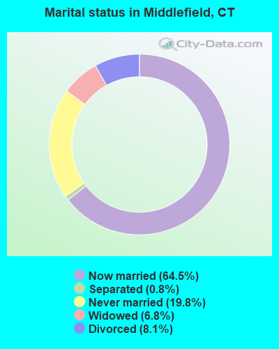
- Never married: 19.8%
- Now married: 64.5%
- Separated: 0.8%
- Widowed: 6.8%
- Divorced: 8.1%
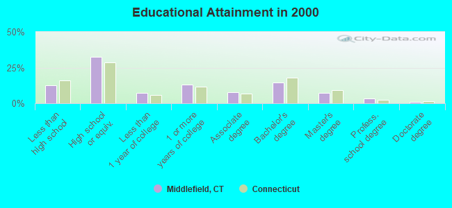
For population 25 years and over in Middlefield:
- High school or higher: 87.2%
- Bachelor's degree or higher: 26.4%
- Graduate or professional degree: 11.6%
- Unemployed: 1.2%
- Mean travel time to work (commute): 22.6 minutes
| Here: | 11.1 |
| Connecticut average: | 12.8 |
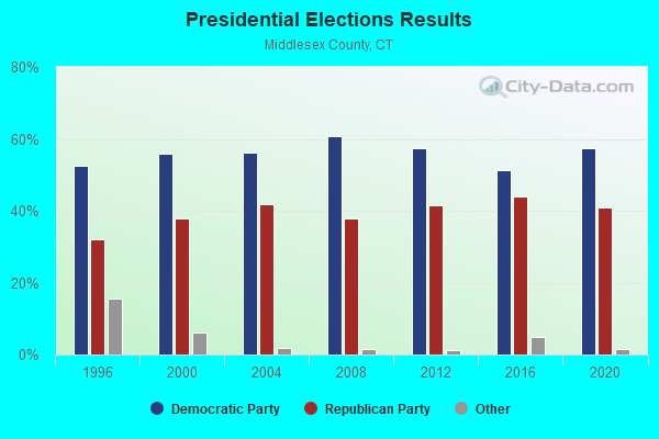
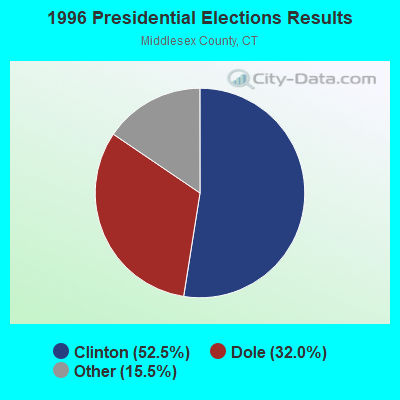
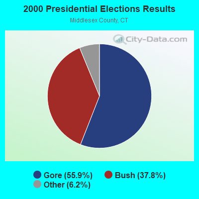
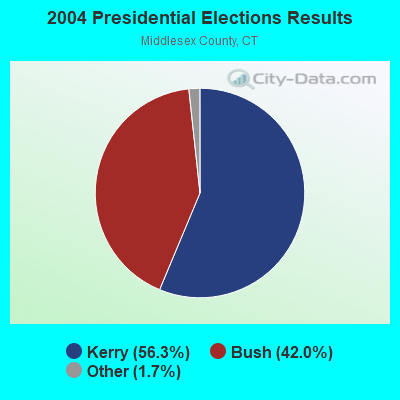
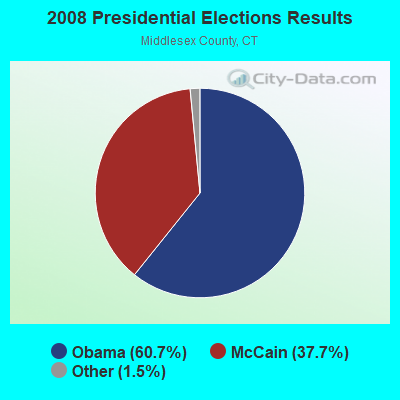
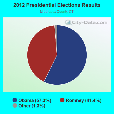
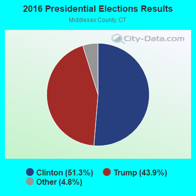

Graphs represent county-level data. Detailed 2008 Election Results
Religion statistics for Middlefield, CT (based on Middlesex County data)
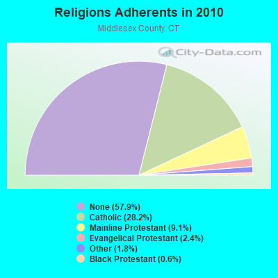
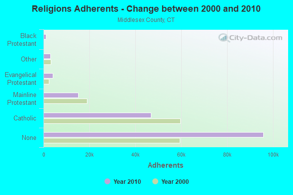
| Religion | Adherents | Congregations |
|---|---|---|
| Catholic | 46,800 | 18 |
| Mainline Protestant | 15,015 | 56 |
| Evangelical Protestant | 3,978 | 29 |
| Other | 2,921 | 11 |
| Black Protestant | 974 | 5 |
| Orthodox | 85 | 1 |
| None | 95,903 | - |
Food Environment Statistics:
| Middlesex County: | 1.71 / 10,000 pop. |
| Connecticut: | 2.21 / 10,000 pop. |
| Middlesex County: | 0.98 / 10,000 pop. |
| Connecticut: | 1.02 / 10,000 pop. |
| Here: | 2.56 / 10,000 pop. |
| Connecticut: | 2.27 / 10,000 pop. |
| Middlesex County: | 10.80 / 10,000 pop. |
| Connecticut: | 9.19 / 10,000 pop. |
| Middlesex County: | 7.0% |
| Connecticut: | 7.3% |
| Middlesex County: | 21.1% |
| State: | 21.5% |
| Middlesex County: | 13.6% |
| Connecticut: | 15.8% |
Strongest AM radio stations in Middlefield:
- WTIC (1080 AM; 50 kW; HARTFORD, CT; Owner: INFINITY RADIO OPERATIONS INC.)
- WMRD (1150 AM; 2 kW; MIDDLETOWN, CT; Owner: CROSSROADS COMMUNICATIONS, INC.)
- WMMW (1470 AM; 2 kW; MERIDEN, CT; Owner: BUCKLEY BROADCASTING CORP OF CT)
- WNNZ (640 AM; 50 kW; WESTFIELD, MA; Owner: CLEAR CHANNEL BROADCASTING LICENSES, INC.)
- WXCT (990 AM; 2 kW; SOUTHINGTON, CT; Owner: THE ADD RADIO GROUP, INC.)
- WLAT (910 AM; 5 kW; NEW BRITAIN, CT; Owner: MEGA COMMUNICATIONS OF NEW BRITAIN LICENSEE, LLC)
- WPOP (1410 AM; 5 kW; HARTFORD, CT; Owner: CAPSTAR TX LIMITED PARTNERSHIP)
- WELI (960 AM; 5 kW; NEW HAVEN, CT; Owner: CLEAR CHANNEL BROADCASTING LICENSES, INC.)
- WCRN (830 AM; 50 kW; WORCESTER, MA; Owner: CARTER BROADCASTING CORPORATION)
- WATR (1320 AM; 5 kW; WATERBURY, CT; Owner: WATR, INC.)
- WFAN (660 AM; 50 kW; NEW YORK, NY; Owner: INFINITY BROADCASTING OPERATIONS, INC.)
- WALE (990 AM; 50 kW; GREENVILLE, RI; Owner: NORTH AMERICAN BROADCASTING CO., INC.)
- WFNW (1380 AM; 5 kW; NAUGATUCK, CT; Owner: CANDIDO DIAS CARRELO)
Strongest FM radio stations in Middlefield:
- WIHS (104.9 FM; MIDDLETOWN, CT; Owner: CONNECTICUT RADIO FELLOWSHIP, INC.)
- WKSS (95.7 FM; HARTFORD-MERIDEN, CT; Owner: CAPSTAR TX LIMITED PARTNERSHIP)
- WWYZ (92.5 FM; WATERBURY, CT; Owner: CAPSTAR TX LIMITED PARTNERSHIP)
- WZMX (93.7 FM; HARTFORD, CT; Owner: INFINITY RADIO OPERATIONS INC.)
- WHCN (105.9 FM; HARTFORD, CT; Owner: CAPSTAR TX LIMITED PARTNERSHIP)
- WMRQ (104.1 FM; WATERBURY, CT; Owner: CAPSTAR TX LIMITED PARTNERSHIP)
- WPKT (90.5 FM; MERIDEN, CT; Owner: CONNECTICUT PUBLIC BROADCASTING, INC)
- WDRC-FM (102.9 FM; HARTFORD, CT; Owner: BUCKLEY BROADCASTING CORPORATION)
- W227AJ (93.3 FM; NORTHFORD, CT; Owner: SACRED HEART UNIVERSITY)
- WRCH (100.5 FM; NEW BRITAIN, CT; Owner: INFINITY RADIO OPERATIONS INC.)
- WKCI-FM (101.3 FM; HAMDEN, CT; Owner: CLEAR CHANNEL BROADCASTING LICENSES, INC.)
- WPLR (99.1 FM; NEW HAVEN, CT; Owner: COX RADIO, INC.)
- WTIC-FM (96.5 FM; HARTFORD, CT; Owner: INFINITY RADIO OPERATIONS INC.)
- WWUH (91.3 FM; WEST HARTFORD, CT; Owner: UNIVERSITY OF HARTFORD)
- WCCC-FM (106.9 FM; HARTFORD, CT; Owner: MARLIN BROADCASTING, LLC)
- WJMJ (88.9 FM; HARTFORD, CT; Owner: ST. THOMAS SEMINARY)
- WYBC-FM (94.3 FM; NEW HAVEN, CT; Owner: YALE BROADCASTING CO., INC.)
- W226AG (93.1 FM; HAMDEN, CT; Owner: SAINT THOMAS SEMINARY)
- WEZN-FM (99.9 FM; BRIDGEPORT, CT; Owner: CXR HOLDINGS, INC.)
- WRXC (90.1 FM; SHELTON, CT; Owner: MONROE BOARD OF EDUCATION)
TV broadcast stations around Middlefield:
- WTIC-TV (Channel 61; HARTFORD, CT; Owner: TRIBUNE TELEVISION COMPANY)
- W11BJ (Channel 11; HARTFORD, CT; Owner: COMMUNICATIONS SITE MANAGEMENT LLC)
- WTXX (Channel 20; WATERBURY, CT; Owner: WTXX INC.)
- WVIT (Channel 30; NEW BRITAIN, CT; Owner: OUTLET BROADCASTING, INC)
- WEDH (Channel 24; HARTFORD, CT; Owner: CONNECTICUT PUBLIC BROADCASTING, INC.)
- WTNH (Channel 8; NEW HAVEN, CT; Owner: WTNH BROADCASTING, INC.)
- WCTX (Channel 59; NEW HAVEN, CT; Owner: WTNH BROADCASTING, INC.)
- WEDY (Channel 65; NEW HAVEN, CT; Owner: CONNECTICUT PUBLIC BROADCASTING, INC.)
- WUVN (Channel 18; HARTFORD, CT; Owner: ENTRAVISION HOLDINGS, LLC)
- W51BZ (Channel 51; NEW HAVEN, CT; Owner: it COMMUNICATIONS, INC.)
- WFSB (Channel 3; HARTFORD, CT; Owner: MEREDITH CORPORATION)
- WHPX (Channel 26; NEW LONDON, CT; Owner: PAXSON HARTFORD LICENSE, INC.)
- WHTX-LP (Channel 10; HARTFORD, CT; Owner: ENTRAVISION HOLDINGS, LLC)
- WHCT-LP (Channel 38; HARTFORD, CT; Owner: VENTURE TECHNOLOGIES GROUP, LLC)
- WRDM-LP (Channel 13; HARTFORD, CT; Owner: ZGS HARTFORD, INC.)
- WMLD-LP (Channel 6; HARTFORD, CT; Owner: HARVARD BROADCASTING, INC.)
- WEDN (Channel 53; NORWICH, CT; Owner: CONNECTICUT PUBLIC BROADCASTING, INC.)
- WEDW (Channel 49; BRIDGEPORT, CT; Owner: CONNECTICUT PUBLIC BROADCASTING, INC.)
- WSAH (Channel 43; BRIDGEPORT, CT; Owner: WSAH LICENSE, INC.)
- National Bridge Inventory (NBI) Statistics
- 18Number of bridges
- 200ft / 61.4mTotal length
- 324,706Total average daily traffic
- 22,960Total average daily truck traffic
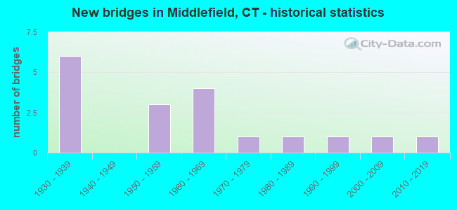
- New bridges - historical statistics
- 61930-1939
- 31950-1959
- 41960-1969
- 11970-1979
- 11980-1989
- 11990-1999
- 12000-2009
- 12010-2019
FCC Registered Cell Phone Towers:
1- 134 Kikapoo Road (59336) (Lat: 41.513611 Lon: -72.745833), Type: Mtower, Structure height: 24.4 m, Overall height: 28.6 m, Call Sign: KNKA239
Assigned Frequencies: 880.020 MHz, 880.020 MHz, 880.020 MHz, 835.020 MHz, 835.020 MHz, 835.020 MHz, 891.510 MHz, 891.510 MHz, 891.510 MHz, 846.510 MHz, 846.510 MHz, 846.510 MHzGrant Date: 09/03/2014, Expiration Date: 10/01/2024, Certifier: David C JatlowRegistrant: At&t Services, Inc., 208 S Akard St, 20f, Dallas, TX 75202, Phone: (855) 699-7073, Fax: (214) 746-6410, Email:
FCC Registered Antenna Towers:
5- Richard Byrne, 393 Jackson Hill Road (Lat: 41.517361 Lon: -72.714167), Type: 48.4, Overall height: 45.8 m, Registrant: Towerco Assets LLC, Afry@towerco.Com, , Cary, Phone: (919) 653-5710
- Richard Byrne, 393 Jackson Hill Road (Lat: 41.517361 Lon: -72.714167), Type: 48.4, Overall height: 45.8 m, Registrant: Towerco Assets LLC, Afry@towerco.Com, , Cary, Phone: (919) 653-5710
- Edward G Roach, 393 Jackson Hill Road (Lat: 41.517361 Lon: -72.714167), Type: 48.4, Structure height: 09007 m, Overall height: 45.8 m, Registrant: Sba 2012 Tc Assets, LLC, Eroach@sbasite.Com, , Boca -Raton, Phone: (561) 995-7670
- Edward G Roach, 393 Jackson Hill Rd (Ct46135-A) (Lat: 41.517361 Lon: -72.714167), Type: 47.2, Structure height: 09007 m, Overall height: 44.5 m, Registrant: Sba 2012 Tc Assets, LLC, Eroach@sbasite.Com, , Boca -Raton, Phone: (561) 995-7670
- Edward G Roach, 393 Jackson Hill Rd (Ct46135-A) (Lat: 41.517361 Lon: -72.714167), Type: 47.2, Structure height: 09007 m, Overall height: 44.5 m, Registrant: Sba 2012 Tc Assets, LLC, Eroach@sbasite.Com, , Boca -Raton, Phone: (561) 995-7670
FCC Registered Broadcast Land Mobile Towers:
5- 396 JACKSON HILL RD, 396 Jackson Hill Rd (Lat: 41.517361 Lon: -72.714194), Type: Mtower, Structure height: 45.7 m, Call Sign: KCC523,
Assigned Frequencies: 453.325 MHz, Grant Date: 10/19/2022, Expiration Date: 01/08/2033, Registrant: Tactical Communications Inc, 29 Soundview Rd, Guilford, CT 06437, Phone: (203) 453-2389, Fax: (203) 458-9247, Email:
- Kickapoo Road Beseck Mountan (Lat: 41.513444 Lon: -72.745639), Call Sign: KAV599, Licensee ID: L00012841,
Assigned Frequencies: 35.8800 MHz, Grant Date: 10/27/1995, Expiration Date: 10/18/2000, Cancellation Date: 12/24/2000, Registrant: Briggs Corp, Brownstone Ave, Portland, CT 06480, Phone: (203) 342-3500
- Lat: 41.515389 Lon: -72.727861, Structure height: 0 m, Call Sign: WPXB698,
Assigned Frequencies: 465.537 MHz, 465.537 MHz, Grant Date: 11/30/2022, Expiration Date: 02/27/2033, Certifier: Terry Parmalee, Registrant: Radio Communciations Associates LLC, 12 Sweetbrier Road, East Granby, CT 06026, Phone: (860) 851-3007, Fax: (860) 658-4144, Email:
- Lat: 41.494000 Lon: -72.711194, Call Sign: WQKG912,
Assigned Frequencies: 462.387 MHz, 467.387 MHz, 452.212 MHz, 457.212 MHz, Grant Date: 05/17/2019, Expiration Date: 05/15/2029, Certifier: John Fresina, Registrant: Cara Enterprises Inc, Salt Lake City, UT 84117-0503, Phone: (801) 278-9728, Fax: (801) 278-7239, Email:
- Lat: 41.501639 Lon: -72.736444, Call Sign: WRKW920,
Assigned Frequencies: 451.562 MHz, 452.787 MHz, 456.562 MHz, 457.062 MHz, 464.587 MHz, Grant Date: 02/24/2021, Expiration Date: 02/24/2031, Certifier: Justin Lonergan, Registrant: Northeastern Communications, Inc., 7 Great Hill Road, Naugatuck, CT 06770, Phone: (203) 575-9008, Email:
FCC Registered Microwave Towers:
4- STATION, End Of Kickapoo Rd (Lat: 41.513139 Lon: -72.746194), Structure height: 6.1 m, Overall height: 9.8 m, Call Sign: WNTT594,
Assigned Frequencies: 21925.0 MHz, Grant Date: 12/07/1993, Expiration Date: 12/07/1998, Phone: (203) 269-4400
- STATION, Kickapoo Rd 2 Mi W Of Center (Lat: 41.513417 Lon: -72.745917), Overall height: 11.6 m, Call Sign: WNTU383,
Assigned Frequencies: 6825.00 MHz, 6865.00 MHz, 6755.00 MHz, Grant Date: 11/19/1998, Expiration Date: 02/08/2009, Cancellation Date: 02/03/2009, Registrant: Schwartz, Woods & Miller, 1233 20th Street, N.W. Suite 610, Washington, DC 20036-7322, Phone: (202) 833-1700, Fax: (202) 833-2351, Email:
- Kickapoo Rd, 2 Mi W Of Ctr Of (Lat: 41.513417 Lon: -72.745639), Structure height: 11.6 m, Call Sign: WPG75,
Assigned Frequencies: 2076.00 MHz, Grant Date: 03/01/1994, Expiration Date: 04/01/2015, Cancellation Date: 02/16/2010, Registrant: Schwartz, Woods & Miller, 1350 Connecticut Avenue, Nw Suite 300, Washington, DC 20036-1717, Phone: (202) 833-1700, Fax: (202) 833-2351, Email:
- Kickapoo Rd, 2 Mi W (Lat: 41.513417 Lon: -72.745917), Structure height: 13.7 m, Overall height: 10.7 m, Call Sign: WBM704,
Assigned Frequencies: 2076.00 MHz, Grant Date: 07/26/1983, Expiration Date: 04/01/2015, Cancellation Date: 02/16/2010, Registrant: Schwartz, Woods & Miller, 1233 20th Street, Nw, Suite 610, Washington, DC 20036-7322, Phone: (202) 833-1700, Fax: (202) 833-2351, Email:
FCC Registered Paging Towers:
3- Mount Beseck (Lat: 41.513417 Lon: -72.745639), Call Sign: WPOL300,
Assigned Frequencies: 454.225 MHz, Grant Date: 03/19/2019, Expiration Date: 04/01/2029, Certifier: Joseph Gottlieb, Registrant: Goosetown Communications, 58 North Harrison Ave, Congers, NY 10920, Phone: (845) 268-7500, Fax: (845) 268-5345, Email:
- End Of Kickapoo Road, 2900' West Of Lake Beseck (Lat: 41.513417 Lon: -72.745639), Call Sign: KNKK858,
Assigned Frequencies: 75.9200 MHz, Grant Date: 08/31/1998, Expiration Date: 07/01/2008, Cancellation Date: 10/05/2004, Certifier: Paul H Kuzia, Registrant: Wilkinson Barker Knauer, LLP, 2300 N Street, N.W., 7th Floor, Washington, DC 20037, Phone: (202) 783-4141, Fax: (202) 783-5851, Email:
- Kickapoo Road (Lat: 41.513444 Lon: -72.745639), Type: Tower, Structure height: 28 m, Call Sign: KNKM752,
Assigned Frequencies: 931.187 MHz, Grant Date: 04/19/1999, Expiration Date: 04/01/2009, Cancellation Date: 05/23/2009, Certifier: Shawn E Endsley, Registrant: Usa Mobility Wireless, Inc., 300 Technology Drive #400, Plano, TX 75074, Phone: (972) 801-1626, Fax: (972) 801-1699, Email:
FCC Registered Amateur Radio Licenses:
15 (See the full list of FCC Registered Amateur Radio Licenses in Middlefield)FAA Registered Aircraft Manufacturers and Dealers:
1 (See the full list of FAA Registered Manufacturers and Dealers in Middlefield)FAA Registered Aircraft:
17 (See the full list of FAA Registered Aircraft)2002 - 2018 National Fire Incident Reporting System (NFIRS) incidents
- Fire incident types reported to NFIRS in Middlefield, CT
- 13747.4%Structure Fires
- 7425.6%Outside Fires
- 5719.7%Mobile Property/Vehicle Fires
- 217.3%Other
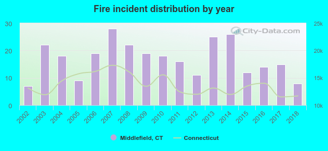 According to the data from the years 2002 - 2018 the average number of fires per year is 17. The highest number of fires - 28 took place in 2007, and the least - 7 in 2002. The data has a growing trend.
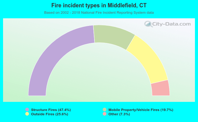 When looking into fire subcategories, the most reports belonged to: Structure Fires (47.4%), and Outside Fires (25.6%).
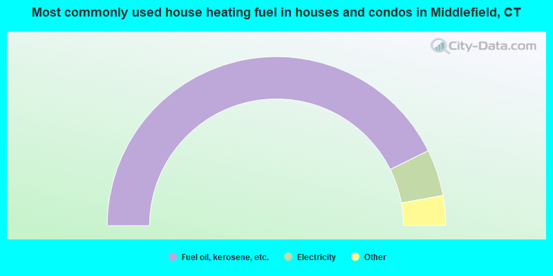
- 85.4%Fuel oil, kerosene, etc.
- 8.9%Electricity
- 3.2%Wood
- 1.9%Bottled, tank, or LP gas
- 0.5%Utility gas
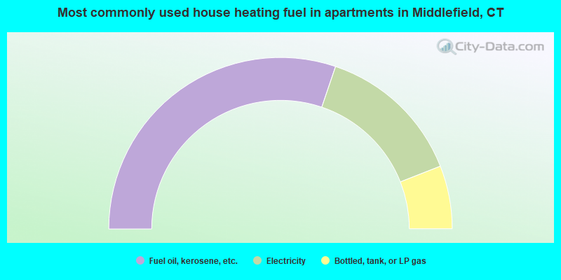
- 60.4%Fuel oil, kerosene, etc.
- 27.7%Electricity
- 11.9%Bottled, tank, or LP gas
Middlefield compared to Connecticut state average:
- Unemployed percentage significantly below state average.
- Black race population percentage significantly below state average.
- Hispanic race population percentage significantly below state average.
- Median age above state average.
- Foreign-born population percentage significantly below state average.
- Renting percentage below state average.
- Length of stay since moving in significantly above state average.
- Number of rooms per house significantly below state average.
- House age significantly below state average.

|
|
Total of 152 patent applications in 2008-2024.