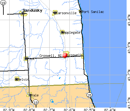
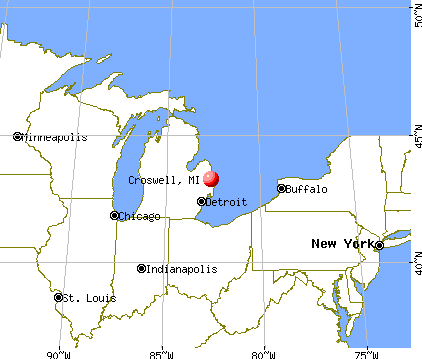
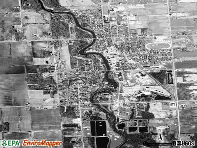
Croswell, Michigan

Croswell: Famous "Mother-in-Law" Swinging Bridge
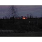
Croswell: Looked outside on a Sunday morning and thought , I need a picture of this!
- add
your
Submit your own pictures of this city and show them to the world
- OSM Map
- General Map
- Google Map
- MSN Map
Population change since 2000: -6.1%
 |
| Males: 1,169 | |
| Females: 1,148 |
| Median resident age: | 41.7 years |
| Michigan median age: | 40.3 years |
Zip codes: 48422.
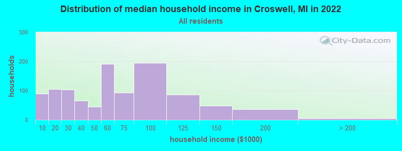
| Croswell: | $54,496 |
| MI: | $66,986 |
Estimated per capita income in 2022: $25,116 (it was $12,686 in 2000)
Croswell city income, earnings, and wages data
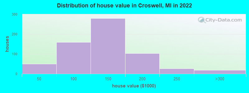
Estimated median house or condo value in 2022: $132,118 (it was $77,800 in 2000)
| Croswell: | $132,118 |
| MI: | $224,400 |
Mean prices in 2022: all housing units: $208,801; detached houses: $218,217; townhouses or other attached units: $163,518; in 2-unit structures: $109,711; in 3-to-4-unit structures: $228,644; in 5-or-more-unit structures: $231,034; mobile homes: $119,827; occupied boats, rvs, vans, etc.: $35,033
Median gross rent in 2022: $737.
(16.7% for White Non-Hispanic residents, 14.3% for Black residents, 5.0% for Hispanic or Latino residents, 4.6% for other race residents, 5.1% for two or more races residents)
Detailed information about poverty and poor residents in Croswell, MI

Compare current foreclosures near Croswell, MI:
| Photo | Address | Area | Beds / Baths | Price | Details |
|---|---|---|---|---|---|

|
#1
Jackson Ct
Croswell, MI 48422
|
- sq. feet
|
- baths - beds |
show details | |

|
#2
Peck Rd
Croswell, MI 48422
|
- sq. feet
|
- baths - beds |
show details | |

|
#3
1/2 Davis St
Croswell, MI 48422
|
- sq. feet
|
- baths - beds |
show details | |

|
#4
Sanilac Ave
Lexington, MI 48450
|
1,200 sq. feet
|
1 baths 3 beds |
$239,900
|
show details |

|
#5
Harrington Rd
Croswell, MI 48422
|
- sq. feet
|
- baths - beds |
show details | |

|
#6
Anderson Ave
Croswell, MI 48422
|
- sq. feet
|
- baths - beds |
show details | |

|
#7
Galbraith Line Rd
Croswell, MI 48422
|
- sq. feet
|
- baths - beds |
show details | |

|
#8
Wildcat Rd
Croswell, MI 48422
|
- sq. feet
|
- baths - beds |
show details | |

|
#9
N Howard Ave
Croswell, MI 48422
|
- sq. feet
|
- baths - beds |
show details | |

|
#10
Cribbins Rd
North Street, MI 48049
|
2,187 sq. feet
|
2 baths 3 beds |
show details |
| Photo | Address | Area | Beds / Baths | Price | Details |
|---|---|---|---|---|---|

|
#11
S Lamotte St
Sandusky, MI 48471
|
1,823 sq. feet
|
1 baths 4 beds |
show details | |

|
#12
Collins Rd
Yale, MI 48097
|
1,703 sq. feet
|
1 baths 3 beds |
show details | |

|
#13
Yale Rd
Yale, MI 48097
|
- sq. feet
|
1 baths 3 beds |
show details | |

|
#14
Mill St
Peck, MI 48466
|
1,900 sq. feet
|
1 baths 4 beds |
show details | |

|
#15
Brown Rd
Avoca, MI 48006
|
1,328 sq. feet
|
1 baths 3 beds |
show details | |

|
#16
Margaret St Apt 13
Sandusky, MI 48471
|
- sq. feet
|
- baths - beds |
show details | |

|
#17
Ojibway Dr
Fort Gratiot, MI 48059
|
- sq. feet
|
- baths - beds |
show details | |

|
#18
5th St
Fort Gratiot, MI 48059
|
- sq. feet
|
- baths - beds |
show details | |

|
#19
Lakeshore Rd
Lexington, MI 48450
|
- sq. feet
|
- baths - beds |
show details | |

|
#20
Margaret St Apt 5
Sandusky, MI 48471
|
- sq. feet
|
- baths - beds |
show details |
| Photo | Address | Area | Beds / Baths | Price | Details |
|---|---|---|---|---|---|

|
#21
W Mechanic St Apt 103
Yale, MI 48097
|
- sq. feet
|
- baths - beds |
show details | |

|
#22
Birch Trail Dr
Port Sanilac, MI 48469
|
- sq. feet
|
- baths - beds |
show details | |

|
#23
Laguna Dr
Fort Gratiot, MI 48059
|
- sq. feet
|
- baths - beds |
show details | |

|
#24
Memoir Dr
Fort Gratiot, MI 48059
|
- sq. feet
|
- baths - beds |
show details | |

|
#25
W Mills St
Sandusky, MI 48471
|
- sq. feet
|
- baths - beds |
show details | |

|
#26
Kimball Dr Unit 1
Fort Gratiot, MI 48059
|
- sq. feet
|
- baths - beds |
show details | |

|
#27
Sandusky Rd
Peck, MI 48466
|
- sq. feet
|
- baths - beds |
show details | |

|
#28
Wildcat Rd
Jeddo, MI 48032
|
- sq. feet
|
- baths - beds |
show details | |

|
#29
S Fulton St
Sandusky, MI 48471
|
- sq. feet
|
- baths - beds |
show details | |

|
#30
Snover Rd
Carsonville, MI 48419
|
- sq. feet
|
- baths - beds |
show details |
| Photo | Address | Area | Beds / Baths | Price | Details |
|---|---|---|---|---|---|

|
#31
Avalon Cir
Lexington, MI 48450
|
- sq. feet
|
- baths - beds |
show details | |

|
#32
Lakeshore Rd Lot 37
Applegate, MI 48401
|
- sq. feet
|
- baths - beds |
show details | |

|
#33
Lakeshore Rd
Applegate, MI 48401
|
- sq. feet
|
- baths - beds |
show details | |

|
#34
S Fulton St
Sandusky, MI 48471
|
- sq. feet
|
- baths - beds |
show details | |

|
#35
North Rd
North Street, MI 48049
|
- sq. feet
|
- baths - beds |
show details | |

|
#36
Lakeshore Rd
Applegate, MI 48401
|
- sq. feet
|
- baths - beds |
show details | |

|
#37
N Ridge Rd
Carsonville, MI 48419
|
- sq. feet
|
- baths - beds |
show details | |

|
#38
Clyde Dr
Fort Gratiot, MI 48059
|
- sq. feet
|
- baths - beds |
show details | |

|
#39
S Lamotte St
Sandusky, MI 48471
|
- sq. feet
|
- baths - beds |
show details | |

|
#40
Worth St
Sandusky, MI 48471
|
- sq. feet
|
- baths - beds |
show details |
| Photo | Address | Area | Beds / Baths | Price | Details |
|---|---|---|---|---|---|

|
#41
E Montevista Dr
Fort Gratiot, MI 48059
|
- sq. feet
|
- baths - beds |
show details | |

|
#42
N Shoreview Dr
Fort Gratiot, MI 48059
|
- sq. feet
|
- baths - beds |
show details | |

|
#43
Shorewood Dr
Fort Gratiot, MI 48059
|
- sq. feet
|
- baths - beds |
show details | |

|
#44
Mill Creek Dr
Avoca, MI 48006
|
- sq. feet
|
- baths - beds |
show details | |

|
#45
Shorewood Blvd
Fort Gratiot, MI 48059
|
- sq. feet
|
- baths - beds |
show details | |

|
#46
Rabidue Rd
North Street, MI 48049
|
- sq. feet
|
- baths - beds |
show details | |

|
#47
Townsend Rd
Applegate, MI 48401
|
- sq. feet
|
- baths - beds |
show details | |

|
#48
Oak Ln
Yale, MI 48097
|
- sq. feet
|
- baths - beds |
show details | |

|
#49
Speaker Rd
Yale, MI 48097
|
- sq. feet
|
- baths - beds |
show details | |

|
Check over 1 million property listings on Foreclosure.com!
|
browse all offers | |||


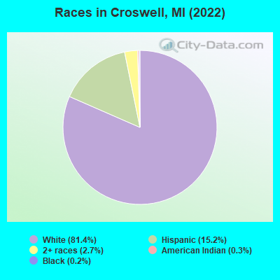
- 2,12581.4%White alone
- 39715.2%Hispanic
- 712.7%Two or more races
- 90.3%American Indian alone
- 60.2%Black alone
- 10.04%Other race alone
Races in Croswell detailed stats: ancestries, foreign born residents, place of birth
According to our research of Michigan and other state lists, there were 14 registered sex offenders living in Croswell, Michigan as of April 28, 2024.
The ratio of all residents to sex offenders in Croswell is 188 to 1.
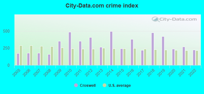
Type |
2009 |
2010 |
2011 |
2012 |
2013 |
2014 |
2015 |
2016 |
2017 |
2018 |
2019 |
2020 |
2021 |
2022 |
|---|---|---|---|---|---|---|---|---|---|---|---|---|---|---|
| Murders (per 100,000) | 1 (40.7) | 1 (40.9) | 0 (0.0) | 0 (0.0) | 0 (0.0) | 1 (42.5) | 0 (0.0) | 0 (0.0) | 0 (0.0) | 1 (44.1) | 0 (0.0) | 0 (0.0) | 0 (0.0) | 0 (0.0) |
| Rapes (per 100,000) | 2 (81.5) | 4 (163.5) | 2 (81.8) | 4 (165.3) | 2 (84.1) | 6 (255.2) | 2 (85.9) | 3 (129.4) | 2 (87.8) | 8 (352.9) | 9 (397.9) | 3 (132.2) | 3 (134.2) | 4 (173.0) |
| Robberies (per 100,000) | 0 (0.0) | 0 (0.0) | 0 (0.0) | 0 (0.0) | 0 (0.0) | 0 (0.0) | 0 (0.0) | 3 (129.4) | 0 (0.0) | 0 (0.0) | 1 (44.2) | 0 (0.0) | 0 (0.0) | 0 (0.0) |
| Assaults (per 100,000) | 4 (162.9) | 8 (326.9) | 7 (286.3) | 9 (371.9) | 7 (294.2) | 8 (340.3) | 9 (386.6) | 13 (560.8) | 9 (395.1) | 5 (220.6) | 5 (221.0) | 6 (264.4) | 7 (313.2) | 1 (43.3) |
| Burglaries (per 100,000) | 15 (611.0) | 20 (817.3) | 32 (1,309) | 14 (578.5) | 6 (252.2) | 17 (723.1) | 8 (343.6) | 11 (474.5) | 4 (175.6) | 4 (176.4) | 1 (44.2) | 5 (220.4) | 9 (402.7) | 4 (173.0) |
| Thefts (per 100,000) | 76 (3,096) | 73 (2,983) | 82 (3,354) | 93 (3,843) | 71 (2,984) | 49 (2,084) | 40 (1,718) | 48 (2,071) | 28 (1,229) | 27 (1,191) | 21 (928.4) | 27 (1,190) | 39 (1,745) | 23 (994.8) |
| Auto thefts (per 100,000) | 2 (81.5) | 9 (367.8) | 1 (40.9) | 2 (82.6) | 1 (42.0) | 1 (42.5) | 1 (43.0) | 3 (129.4) | 3 (131.7) | 0 (0.0) | 1 (44.2) | 5 (220.4) | 1 (44.7) | 7 (302.8) |
| Arson (per 100,000) | 1 (40.7) | 2 (81.7) | 0 (0.0) | 1 (41.3) | 1 (42.0) | 0 (0.0) | 0 (0.0) | 0 (0.0) | 0 (0.0) | 2 (88.2) | 0 (0.0) | 0 (0.0) | 0 (0.0) | 0 (0.0) |
| City-Data.com crime index | 352.3 | 483.9 | 351.7 | 407.4 | 266.5 | 494.7 | 242.3 | 380.9 | 221.2 | 474.6 | 419.5 | 239.3 | 271.6 | 223.2 |
The City-Data.com crime index weighs serious crimes and violent crimes more heavily. Higher means more crime, U.S. average is 246.1. It adjusts for the number of visitors and daily workers commuting into cities.
Crime rate in Croswell detailed stats: murders, rapes, robberies, assaults, burglaries, thefts, arson
Full-time law enforcement employees in 2021, including police officers: 5 (5 officers - 4 male; 1 female).
| Officers per 1,000 residents here: | 2.24 |
| Michigan average: | 1.86 |
 Recent articles from our blog. Our writers, many of them Ph.D. graduates or candidates, create easy-to-read articles on a wide variety of topics.

 | Where in Michigan resembles Western Washington but w/o rain? (43 replies) |
| Top city's in MI (36 replies) |
| Buying Michigan products (25 replies) |
| Where to settle?? (1 reply) |
| Port Huron, MI (17 replies) |
| Want to move (11 replies) |
Latest news from Croswell, MI collected exclusively by city-data.com from local newspapers, TV, and radio stations
Ancestries: German (18.0%), English (9.1%), American (8.0%), Polish (5.8%), Irish (4.4%), Scottish (2.2%).
Current Local Time: EST time zone
Elevation: 736 feet
Land area: 2.28 square miles.
Population density: 1,014 people per square mile (low).
32 residents are foreign born
| This city: | 1.2% |
| Michigan: | 6.9% |
Median real estate property taxes paid for housing units with mortgages in 2022: $1,449 (1.0%)
Median real estate property taxes paid for housing units with no mortgage in 2022: $1,326 (1.2%)
Nearest city with pop. 50,000+: Shelby, MI  (46.4 miles , pop. 65,159).
Nearest city with pop. 200,000+: Detroit, MI (65.8 miles , pop. 951,270).
Nearest city with pop. 1,000,000+: Chicago, IL (275.9 miles , pop. 2,896,016).
Nearest cities:
), ), ), ), Latitude: 43.27 N, Longitude: 82.62 W
Area code: 810
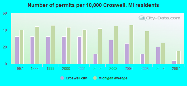
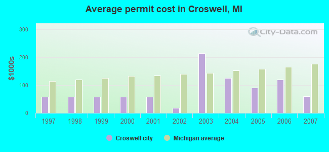
Single-family new house construction building permits:
- 2007: 1 building, cost: $60,000
- 2006: 5 buildings, average cost: $119,000
- 2005: 3 buildings, average cost: $90,000
- 2004: 6 buildings, average cost: $125,000
- 2003: 7 buildings, average cost: $214,300
- 2002: 3 buildings, average cost: $18,300
- 2001: 8 buildings, average cost: $58,000
- 2000: 8 buildings, average cost: $58,000
- 1999: 8 buildings, average cost: $58,000
- 1998: 8 buildings, average cost: $58,000
- 1997: 8 buildings, average cost: $58,000
| Here: | 4.3% |
| Michigan: | 3.5% |
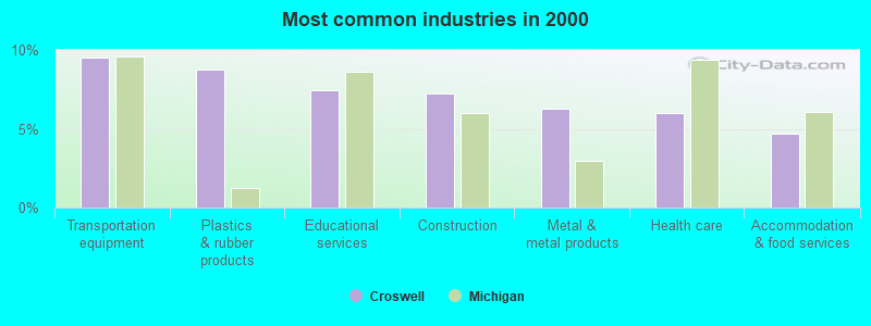
- Transportation equipment (9.5%)
- Plastics & rubber products (8.8%)
- Educational services (7.4%)
- Construction (7.2%)
- Metal & metal products (6.3%)
- Health care (6.0%)
- Accommodation & food services (4.7%)
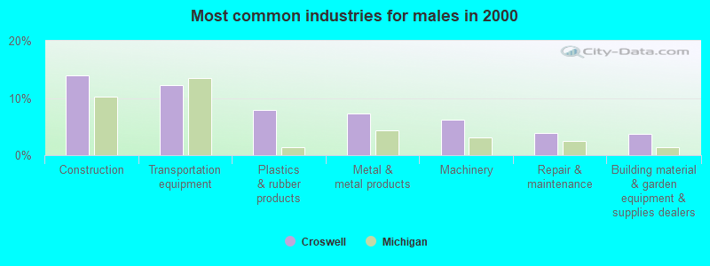
- Construction (13.9%)
- Transportation equipment (12.3%)
- Plastics & rubber products (7.9%)
- Metal & metal products (7.3%)
- Machinery (6.2%)
- Repair & maintenance (3.9%)
- Building material & garden equipment & supplies dealers (3.7%)
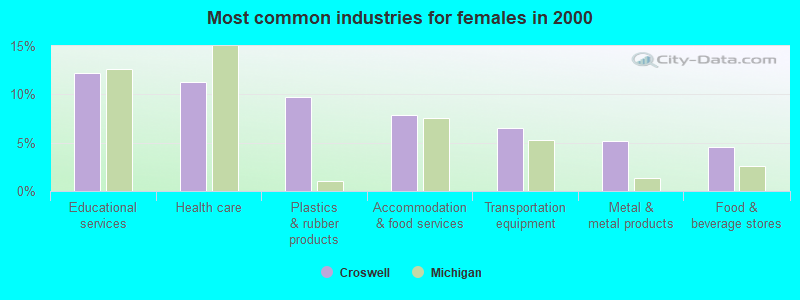
- Educational services (12.3%)
- Health care (11.3%)
- Plastics & rubber products (9.7%)
- Accommodation & food services (7.9%)
- Transportation equipment (6.5%)
- Metal & metal products (5.1%)
- Food & beverage stores (4.5%)
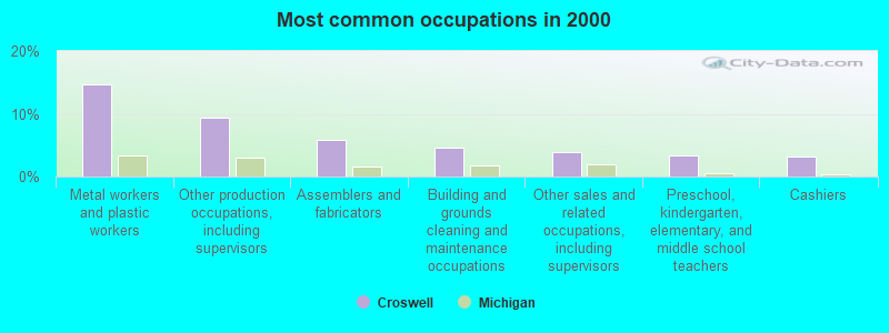
- Metal workers and plastic workers (14.7%)
- Other production occupations, including supervisors (9.3%)
- Assemblers and fabricators (5.9%)
- Building and grounds cleaning and maintenance occupations (4.7%)
- Other sales and related occupations, including supervisors (3.8%)
- Preschool, kindergarten, elementary, and middle school teachers (3.4%)
- Cashiers (3.1%)
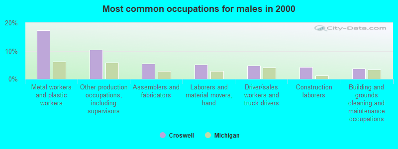
- Metal workers and plastic workers (17.4%)
- Other production occupations, including supervisors (10.5%)
- Assemblers and fabricators (5.5%)
- Laborers and material movers, hand (5.1%)
- Driver/sales workers and truck drivers (4.8%)
- Construction laborers (4.2%)
- Building and grounds cleaning and maintenance occupations (3.7%)
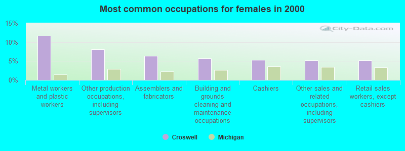
- Metal workers and plastic workers (11.7%)
- Other production occupations, including supervisors (8.1%)
- Assemblers and fabricators (6.3%)
- Building and grounds cleaning and maintenance occupations (5.7%)
- Cashiers (5.3%)
- Other sales and related occupations, including supervisors (5.1%)
- Retail sales workers, except cashiers (5.1%)
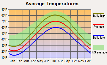
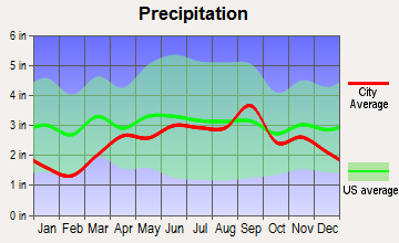
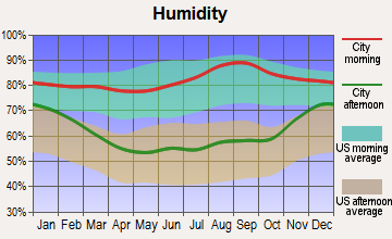
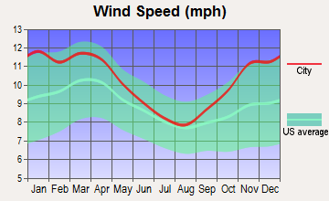
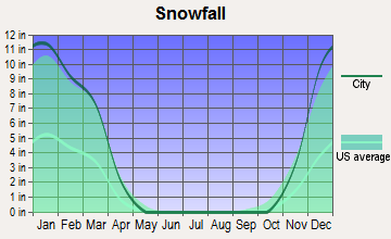
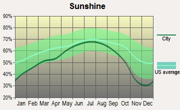
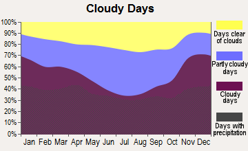
Average climate in Croswell, Michigan
Based on data reported by over 4,000 weather stations
|
|

(lower is better)
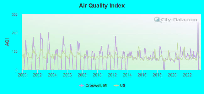
Air Quality Index (AQI) level in 2022 was 78.2. This is about average.
| City: | 78.2 |
| U.S.: | 72.6 |
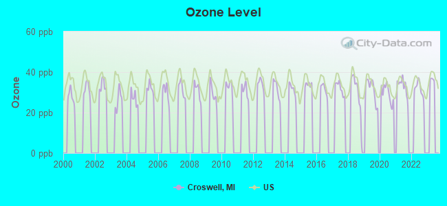
Ozone [ppb] level in 2022 was 31.8. This is about average. Closest monitor was 23.5 miles away from the city center.
| City: | 31.8 |
| U.S.: | 33.3 |
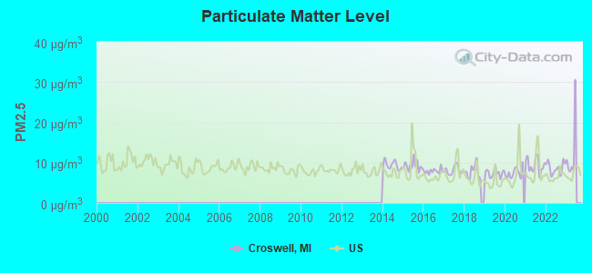
Particulate Matter (PM2.5) [µg/m3] level in 2022 was 8.61. This is about average. Closest monitor was 23.5 miles away from the city center.
| City: | 8.61 |
| U.S.: | 8.11 |
Tornado activity:
Croswell-area historical tornado activity is below Michigan state average. It is 32% smaller than the overall U.S. average.
On 6/8/1953, a category F4 (max. wind speeds 207-260 mph) tornado 11.5 miles away from the Croswell city center injured 23 people and caused between $50,000 and $500,000 in damages.
On 5/21/1953, a category F4 tornado 22.6 miles away from the city center killed 2 people and injured 68 people and caused between $500,000 and $5,000,000 in damages.
Earthquake activity:
Croswell-area historical earthquake activity is significantly above Michigan state average. It is 60% smaller than the overall U.S. average.On 9/25/1998 at 19:52:52, a magnitude 5.2 (4.8 MB, 4.3 MS, 5.2 LG, 4.5 MW, Depth: 3.1 mi, Class: Moderate, Intensity: VI - VII) earthquake occurred 167.6 miles away from the city center
On 1/31/1986 at 16:46:43, a magnitude 5.0 (5.0 MB) earthquake occurred 137.5 miles away from Croswell center
On 7/12/1986 at 08:19:37, a magnitude 4.5 (4.5 MB, Class: Light, Intensity: IV - V) earthquake occurred 209.4 miles away from the city center
On 5/2/2015 at 16:23:07, a magnitude 4.2 (4.2 MW, Depth: 2.8 mi) earthquake occurred 159.5 miles away from Croswell center
On 8/23/2011 at 17:51:04, a magnitude 5.8 (5.8 MW, Depth: 3.7 mi) earthquake occurred 444.9 miles away from the city center
On 6/10/2019 at 14:50:45, a magnitude 4.0 (4.0 MB, Depth: 1.2 mi) earthquake occurred 125.1 miles away from the city center
Magnitude types: regional Lg-wave magnitude (LG), body-wave magnitude (MB), surface-wave magnitude (MS), moment magnitude (MW)
Natural disasters:
The number of natural disasters in Sanilac County (11) is smaller than the US average (15).Major Disasters (Presidential) Declared: 6
Emergencies Declared: 4
Causes of natural disasters: Floods: 6, Storms: 5, Snowstorms: 2, Tornadoes: 2, Blizzard: 1, Hurricane: 1, Winter Storm: 1, Other: 1 (Note: some incidents may be assigned to more than one category).
Hospitals and medical centers near Croswell:
- MEDILODGE OF YALE, INC (Nursing Home, about 13 miles away; YALE, MI)
- HEALTHSTAR HOME CARE (Home Health Center, about 13 miles away; LAKEPORT, MI)
- YALE COMMUNITY HOSPITAL INC (Hospital, about 13 miles away; YALE, MI)
- SANILAC MEDICAL CARE FACILITY (Nursing Home, about 15 miles away; SANDUSKY, MI)
- MCKENZIE MEMORIAL HOSPITAL Critical Access Hospitals (about 15 miles away; SANDUSKY, MI)
- FMC - SANDUSKY (Dialysis Facility, about 16 miles away; SANDUSKY, MI)
- ASSOCIATED HOME CARE (Home Health Center, about 16 miles away; SANDUSKY, MI)
Airports located in Croswell:
- Arnold Field Airport (55G) (Runways: 2, Itinerant Ops: 175, Local Ops: 175)
- Darrell's Landing Airport (4MI8) (Runways: 1)
Colleges/universities with over 2000 students nearest to Croswell:
- St Clair County Community College (about 23 miles; Port Huron, MI; Full-time enrollment: 3,057)
- Oakland University (about 52 miles; Rochester Hills, MI; FT enrollment: 16,449)
- Baker College of Clinton Township (about 52 miles; Clinton Township, MI; FT enrollment: 3,413)
- Baker College of Auburn Hills (about 53 miles; Auburn Hills, MI; FT enrollment: 2,284)
- Mott Community College (about 56 miles; Flint, MI; FT enrollment: 7,394)
- Macomb Community College (about 56 miles; Warren, MI; FT enrollment: 15,669)
- University of Michigan-Flint (about 57 miles; Flint, MI; FT enrollment: 6,284)
Public high school in Croswell:
- CROSWELL-LEXINGTON HIGH SCHOOL (Students: 769, Location: 5461 PECK RD, Grades: 9-12)
Public elementary/middle schools in Croswell:
- CROSWELL-LEXINGTON MIDDLE SCHOOL (Students: 743, Location: 5485 PECK RD, Grades: 5-8)
- FROSTICK SCHOOL (Students: 457, Location: 57 SOUTH HOWARD AVE, Grades: PK-4)
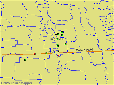
Points of interest:
Notable locations in Croswell: Croswell Station (A), Croswell Emergency Medical Services (B), William Aitkin Memorial Library (C), Croswell Police Department (D), Croswell Fire Department (E). Display/hide their locations on the map
Churches in Croswell include: Saint Patrick Parish (A), Croswell Community Church (B), Croswell Wesleyan Church (C), Croswell United Methodist Church (D), First Presbyterian Church (E), Croswell Community Church (F). Display/hide their locations on the map
Cemetery: Croswell Village Cemetery (1). Display/hide its location on the map
Creek: Mills Creek (A). Display/hide its location on the map
Parks in Croswell include: Harrington Street Park (1), Truman Park (2), Riverbend Park (3). Display/hide their locations on the map
Hotel: Cros-Lex Lodge (5060 Peck Road).
Drinking water stations with addresses in Croswell and their reported violations in the past:
BUEL HILL MOBILE HOME PARK (Population served: 378, Groundwater):Past monitoring violations:COUNTRY HILL PINES (Population served: 150, Groundwater):
- Lead Consumer Notice - In DEC-30-2013, Contaminant: Lead and Copper Rule. Follow-up actions: St Violation/Reminder Notice (FEB-12-2014), St Compliance achieved (MAR-28-2014)
- 3 routine major monitoring violations
Past monitoring violations:
- Lead Consumer Notice - In DEC-30-2013, Contaminant: Lead and Copper Rule. Follow-up actions: St Violation/Reminder Notice (FEB-12-2014), St Compliance achieved (MAR-28-2014)
- 3 routine major monitoring violations
Drinking water stations with addresses in Croswell that have no violations reported:
- CROSWELL, CITY OF (Population served: 2,447, Primary Water Source Type: Groundwater)
| This city: | 2.5 people |
| Michigan: | 2.5 people |
| This city: | 66.8% |
| Whole state: | 66.0% |
| This city: | 8.2% |
| Whole state: | 6.4% |
Likely homosexual households (counted as self-reported same-sex unmarried-partner households)
- Lesbian couples: 0.4% of all households
- Gay men: 0.1% of all households
5 people in workers' group living quarters and job corps centers in 2010
15 people in homes for the mentally retarded in 2000
5 people in other group homes in 2000
Banks with branches in Croswell (2011 data):
- Eastern Michigan Bank: Drive-In Branch, at 65 North Howard Avenue, Loan Center Branch. Info updated 2006/11/03: Bank assets: $259.8 mil, Deposits: $233.8 mil, local headquarters, positive income, Agricultural Specialization, 11 total offices, Holding Company: Eastern Michigan Financial Corporation
- Talmer Bank and Trust: Croswell at 37 N. Howard Street, branch established on 1937/01/01. Info updated 2011/05/03: Bank assets: $2,126.7 mil, Deposits: $1,722.6 mil, headquarters in Troy, MI, positive income, Commercial Lending Specialization, 56 total offices, Holding Company: Talmer Bancorp Inc.
For population 15 years and over in Croswell:
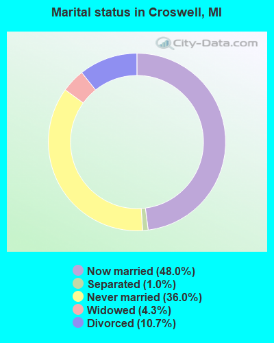
- Never married: 36.0%
- Now married: 48.0%
- Separated: 1.0%
- Widowed: 4.3%
- Divorced: 10.7%
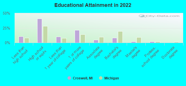
For population 25 years and over in Croswell:
- High school or higher: 88.2%
- Bachelor's degree or higher: 11.4%
- Graduate or professional degree: 3.5%
- Unemployed: 7.4%
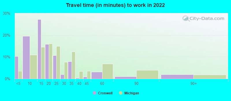
- Mean travel time to work (commute): 28.7 minutes
| Here: | 9.0 |
| Michigan average: | 11.0 |
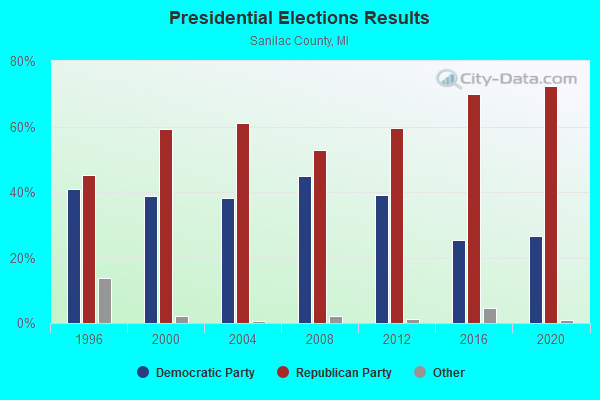
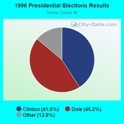
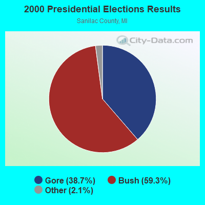
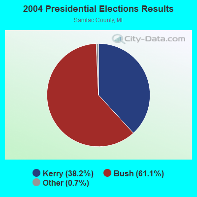
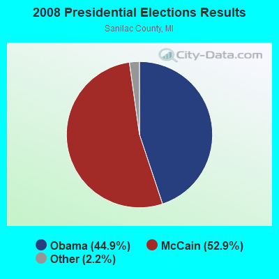
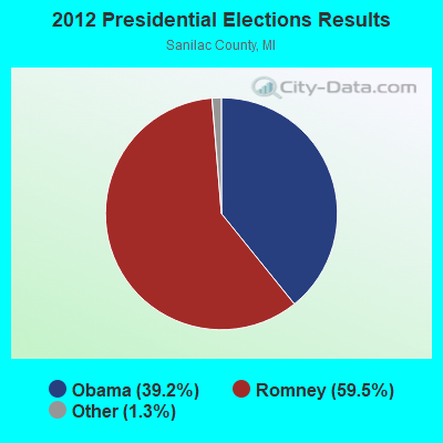
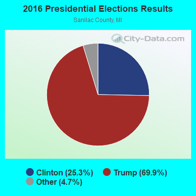
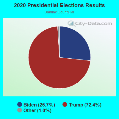
Graphs represent county-level data. Detailed 2008 Election Results
Religion statistics for Croswell, MI (based on Sanilac County data)
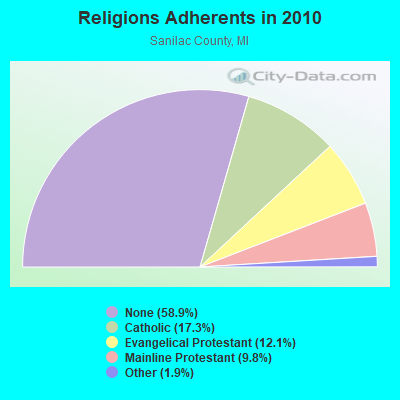
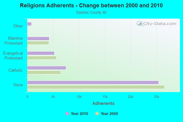
| Religion | Adherents | Congregations |
|---|---|---|
| Catholic | 7,460 | 10 |
| Evangelical Protestant | 5,233 | 40 |
| Mainline Protestant | 4,222 | 31 |
| Other | 813 | 7 |
| None | 25,386 | - |
Food Environment Statistics:
| Sanilac County: | 2.99 / 10,000 pop. |
| Michigan: | 2.34 / 10,000 pop. |
| Sanilac County: | 0.23 / 10,000 pop. |
| Michigan: | 0.18 / 10,000 pop. |
| Here: | 2.76 / 10,000 pop. |
| Michigan: | 1.52 / 10,000 pop. |
| Sanilac County: | 4.37 / 10,000 pop. |
| Michigan: | 2.99 / 10,000 pop. |
| This county: | 6.20 / 10,000 pop. |
| State: | 6.80 / 10,000 pop. |
| Sanilac County: | 9.7% |
| Michigan: | 9.7% |
| This county: | 30.9% |
| Michigan: | 29.7% |
| Sanilac County: | 10.5% |
| Michigan: | 13.4% |
Health and Nutrition:
| Croswell: | 48.7% |
| Michigan: | 50.3% |
| This city: | 45.8% |
| Michigan: | 47.9% |
| Here: | 29.0 |
| Michigan: | 28.7 |
| Croswell: | 21.1% |
| Michigan: | 20.6% |
| Croswell: | 11.6% |
| Michigan: | 10.4% |
| Croswell: | 6.8 |
| Michigan: | 6.8 |
| Croswell: | 35.2% |
| Michigan: | 34.1% |
| Here: | 55.8% |
| Michigan: | 57.0% |
| This city: | 78.9% |
| Michigan: | 79.6% |
More about Health and Nutrition of Croswell, MI Residents
| Local government employment and payroll (March 2022) | |||||
| Function | Full-time employees | Monthly full-time payroll | Average yearly full-time wage | Part-time employees | Monthly part-time payroll |
|---|---|---|---|---|---|
| Police Protection - Officers | 5 | $26,803 | $64,327 | 0 | $0 |
| Health | 4 | $22,463 | $67,389 | 8 | $14,730 |
| Sewerage | 3 | $16,687 | $66,748 | 0 | $0 |
| Streets and Highways | 2 | $8,124 | $48,744 | 0 | $0 |
| Other Government Administration | 2 | $14,292 | $85,752 | 0 | $0 |
| Financial Administration | 2 | $4,606 | $27,636 | 0 | $0 |
| Electric Power | 2 | $14,259 | $85,554 | 0 | $0 |
| Water Supply | 2 | $8,802 | $52,812 | 0 | $0 |
| Parks and Recreation | 1 | $4,019 | $48,228 | 1 | $842 |
| Solid Waste Management | 1 | $4,358 | $52,296 | 0 | $0 |
| Other and Unallocable | 0 | $0 | 1 | $433 | |
| Police - Other | 0 | $0 | 2 | $2,114 | |
| Fire - Other | 0 | $0 | 1 | $482 | |
| Totals for Government | 24 | $124,412 | $62,206 | 13 | $18,602 |
Croswell government finances - Expenditure in 2021 (per resident):
- Current Operations - General - Other: $3,904,000 ($1684.94)
Regular Highways: $1,155,000 ($498.49)
Sewerage: $1,094,000 ($472.16)
Police Protection: $626,000 ($270.18)
Central Staff Services: $187,000 ($80.71)
Solid Waste Management: $176,000 ($75.96)
Local Fire Protection: $123,000 ($53.09)
Financial Administration: $100,000 ($43.16)
Parks and Recreation: $63,000 ($27.19)
Judicial and Legal Services: $58,000 ($25.03)
Health - Other: $49,000 ($21.15)
General Public Buildings: $19,000 ($8.20)
Libraries: $5,000 ($2.16)
- General - Interest on Debt: $89,000 ($38.41)
- Other Capital Outlay - Sewerage: $5,481,000 ($2365.56)
Regular Highways: $141,000 ($60.85)
General - Other: $54,000 ($23.31)
Public Welfare - Other: $18,000 ($7.77)
- Total Salaries and Wages: $1,878,000 ($810.53)
- Water Utilities - Interest on Debt: $16,000 ($6.91)
Croswell government finances - Revenue in 2021 (per resident):
- Charges - Sewerage: $1,149,000 ($495.90)
Other: $1,035,000 ($446.70)
- Federal Intergovernmental - Other: $3,448,000 ($1488.13)
Public Welfare: $14,000 ($6.04)
- Local Intergovernmental - Highways: $73,000 ($31.51)
Public Welfare: $21,000 ($9.06)
- Miscellaneous - Special Assessments: $597,000 ($257.66)
General Revenue - Other: $237,000 ($102.29)
Rents: $59,000 ($25.46)
Donations From Private Sources: $12,000 ($5.18)
Interest Earnings: $11,000 ($4.75)
Sale of Property: $5,000 ($2.16)
- Revenue - Electric Utilities: $3,980,000 ($1717.74)
Water Utilities: $449,000 ($193.79)
- State Intergovernmental - Highways: $375,000 ($161.85)
General Local Government Support: $315,000 ($135.95)
Other: $220,000 ($94.95)
- Tax - Property: $750,000 ($323.69)
Other License: $2,000 ($0.86)
Croswell government finances - Debt in 2021 (per resident):
- Long Term Debt - Outstanding Unspecified Public Purpose: $4,993,000 ($2154.94)
Beginning Outstanding - Unspecified Public Purpose: $3,200,000 ($1381.10)
Issue, Unspecified Public Purpose: $1,919,000 ($828.23)
Retired Unspecified Public Purpose: $126,000 ($54.38)
Croswell government finances - Cash and Securities in 2021 (per resident):
- Other Funds - Cash and Securities: $7,921,000 ($3418.64)
| Businesses in Croswell, MI | ||||
| Name | Count | Name | Count | |
|---|---|---|---|---|
| H&R Block | 1 | McDonald's | 1 | |
| MasterBrand Cabinets | 1 | True Value | 1 | |
Strongest AM radio stations in Croswell:
- WWJ (950 AM; 50 kW; DETROIT, MI; Owner: INFINITY BROADCASTING OPERATIONS, INC.)
- WXYT (1270 AM; 50 kW; DETROIT, MI; Owner: INFINITY BROADCASTING CORP. OF DETROIT)
- WJR (760 AM; 50 kW; DETROIT, MI; Owner: ABC, INC.)
- WMIC (660 AM; daytime; 1 kW; SANDUSKY, MI; Owner: SANILAC BROADCASTING COMPANY)
- WOAP (1080 AM; 50 kW; OWOSSO, MI)
- WFDF (910 AM; 50 kW; FLINT, MI; Owner: ABC, INC.)
- WDFN (1130 AM; 50 kW; DETROIT, MI; Owner: AMFM RADIO LICENSES, L.L.C.)
- WCHB (1200 AM; 50 kW; TAYLOR, MI; Owner: RADIO ONE OF DETROIT, LLC)
- WPHM (1380 AM; 5 kW; PORT HURON, MI; Owner: LIGGETT COMMUNICATIONS, L.L.C.)
- WKNR (850 AM; 50 kW; CLEVELAND, OH; Owner: CARON BROADCASTING, INC.)
- WLSP (1530 AM; daytime; 5 kW; LAPEER, MI; Owner: REGENT BROADCASTING OF FLINT INC.)
- WTAM (1100 AM; 50 kW; CLEVELAND, OH; Owner: JACOR BROADCASTING CORPORATION)
- WUFL (1030 AM; daytime; 5 kW; STERLING HEIGHTS, MI; Owner: FAMILY LIFE BROADCASTING SYSTEM)
Strongest FM radio stations in Croswell:
- WNFR (90.7 FM; SANDUSKY, MI; Owner: ROSS BIBLE CHURCH)
- WBTI (96.9 FM; LEXINGTON, MI; Owner: LIGGETT COMMUNICATIONS, L.L.C.)
- WTGV-FM (97.7 FM; SANDUSKY, MI; Owner: SANILAC BROADCASTING COMPANY)
- WGRT (102.3 FM; PORT HURON, MI; Owner: PORT HURON FAMILY RADIO, INC.)
- WBGV (92.5 FM; MARLETTE, MI; Owner: GB BROADCASTING COMPANY)
- WSAQ (107.1 FM; PORT HURON, MI; Owner: LIGGETT COMMUNICATIONS, L.L.C.)
TV broadcast stations around Croswell:
- WDCP-TV (Channel 35; BAD AXE, MI; Owner: DELTA COLLEGE)
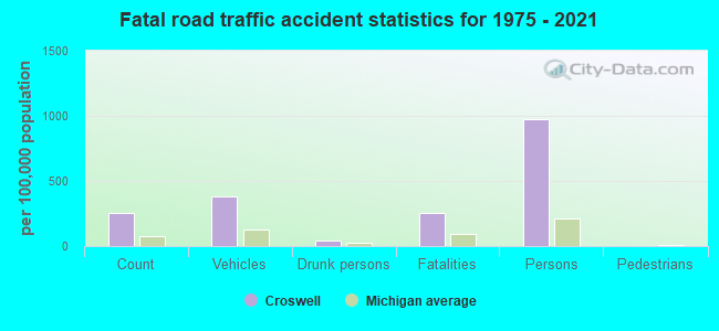
Croswell fatal accident list:
Jul 12, 2003 02:31 AM, Ward St, Vehicles: 1, Persons: 7, Fatalities: 1, Drunk persons involved: 1
Aug 31, 2000 08:20 AM, Sr-90, Lat: 43.264135, Lon: -82.629550, Vehicles: 2, Persons: 4, Fatalities: 1
May 3, 1999 05:38 PM, Sr-90, Lat: 43.264135, Lon: -82.629550, Vehicles: 2, Persons: 3, Fatalities: 1
Jan 10, 1976 09:10 PM, Vehicles: 1, Persons: 3, Fatalities: 1
Jan 10, 1975 09:10 PM, Vehicles: 1, Persons: 3, Fatalities: 1
- National Bridge Inventory (NBI) Statistics
- 9Number of bridges
- 72ft / 22.4mTotal length
- $1,723,000Total costs
- 25,911Total average daily traffic
- 1,561Total average daily truck traffic
- 43,351Total future (year 2007) average daily traffic
FCC Registered Cell Phone Towers:
2- 5247 Wildcat Rd (94864) (Lat: 43.273611 Lon: -82.587778), Type: Gtower, Structure height: 74.7 m, Overall height: 81.7 m, Call Sign: KNKN711, Licensee ID: L00128694
Assigned Frequencies: 869.040 MHz, 869.040 MHz, 869.040 MHz, 824.040 MHz, 824.040 MHz, 824.040 MHz, 890.010 MHz, 890.010 MHz, 890.010 MHz, 845.010 MHz, 845.010 MHz, 845.010 MHzGrant Date: 09/01/2020, Expiration Date: 10/01/2030, Certifier: Michael P GogginRegistrant: At&t Mobility Spectrum, LLC
- 0.5 Miles Se Of Intersection Of Harrington & Wildcat Roads (Lat: 43.273639 Lon: -82.587694), Structure height: 81.6 m, Call Sign: KNKQ268
Assigned Frequencies: 880.020 MHz, 891.510 MHz, 835.020 MHz, 846.510 MHzGrant Date: 08/31/2021, Expiration Date: 10/01/2031, Certifier: Edwin H EichlerRegistrant: Hill & Welch, 1116 Heartfields Drive, Silver Spring, MD 20904, Phone: (202) 321-1448, Fax: (301) 622-2864, Email:
FCC Registered Antenna Towers:
5- Carol McCarty, 5247 Wildcat Rd (Lat: 43.273611 Lon: -82.587778), Type: 81.6, Structure height: 26151 m, Overall height: 74.6 m, Registrant: Hill & Welch, Welchlaw@earthlink.Net, , Silve-r Spring, Phone: (202) 321-1448
- Jacqui Castrichini, Across From 5821 Kilgore Road (Lat: 43.255694 Lon: -82.710583), Type: 76.2, Structure height: 26151 m, Overall height: 74.7 m, Registrant: Jcastrichini@impact7g.Com, 8951 Windsor Parkway, Johns-ton, Phone: (161) 981-8128
- Jessica Dunk, Across From 5821 Kilgore Road (Lat: 43.255694 Lon: -82.710583), Type: 76.2, Structure height: 26151 m, Overall height: 74.7 m, Registrant: Jcastrichini@impact7g.Com, 8951 Windsor Parkway, Johns-ton, Phone: (161) 981-8128
- Jessica Dunk, Across From 5821 Kilgore Road (Lat: 43.255694 Lon: -82.710583), Type: 76.2, Structure height: 26151 m, Overall height: 74.7 m, Registrant: Att Services, Attnrc@att.Com, , Provi-dence, Phone: (855) 699-7073
- 5247 Wildcat Rd (Lat: 43.273611 Lon: -82.587778), Type: 81.6, Overall height: 74.6 m, Registrant: Thumb Cellular Limited Partnership Dba , Pigeo-n, Phone: (517) 453-4333
FCC Registered Broadcast Land Mobile Towers:
8 (See the full list of FCC Registered Broadcast Land Mobile Towers in Croswell, MI)FCC Registered Microwave Towers:
3- Croswell2Ithaca, Lat: 43.188056 Lon: -84.585833, Type: Silo, Structure height: 21 m, Overall height: 22 m, Call Sign: WQKB941,
Assigned Frequencies: 3650.00 MHz, Grant Date: 04/10/2019, Expiration Date: 10/17/2020, Cancellation Date: 12/19/2020, Certifier: Benjamin H Trahan, Registrant: Skyweb Networks, 2710 State Street, Saginaw, MI 48602, Phone: (989) 906-0467, Email:
- Wildcat, Corner Of Wildcat & M-90 (Lat: 43.264528 Lon: -82.589583), Type: Tower, Structure height: 30.5 m, Call Sign: WQNZ850,
Assigned Frequencies: 11325.0 MHz, 11325.0 MHz, 11325.0 MHz, 11325.0 MHz, Grant Date: 06/08/2021, Expiration Date: 07/20/2031, Certifier: Dawn Cubitt, Registrant: Radyn, Inc, Silver Spring, MD 20914, Phone: (301) 493-5171, Fax: (301) 576-4553, Email:
- 1212-CROSWELL, 159 S Howard Ave (Lat: 43.266778 Lon: -82.615694), Type: Silo, Structure height: 48.8 m, Overall height: 57.9 m, Call Sign: WRCN637,
Assigned Frequencies: 17900.0 MHz, 17900.0 MHz, 17900.0 MHz, 17900.0 MHz, 17900.0 MHz, 17900.0 MHz, 17900.0 MHz, 17900.0 MHz, 17900.0 MHz, Grant Date: 11/20/2018, Expiration Date: 11/20/2028, Certifier: Leroy A Koglin Jr, Registrant: Micronet Communications, Inc., 812 Lexington Dr, Plano, TX 75075, Phone: (972) 422-7200, Email:
FCC Registered Paging Towers:
1- 5247 Wildcat Road (Lat: 43.273611 Lon: -82.587694), Overall height: 69.5 m, Call Sign: KNKO294,
Assigned Frequencies: 931.337 MHz, Grant Date: 08/05/2014, Expiration Date: 06/22/2024, Certifier: J. Roy Pottle, Registrant: Wilkinson Barker Knauer, LLP, 1800 M Street, N.W., Suite 800n, Washington, DC 20036, Phone: (202) 783-4141, Fax: (202) 783-5851, Email:
FCC Registered Maritime Coast & Aviation Ground Towers:
1- Arnold Airport (Lat: 43.300028 Lon: -82.611028), Call Sign: KAD6,
Assigned Frequencies: 122.800 MHz, 156.450 MHz, 156.800 MHz, 156.925 MHz, Grant Date: 05/19/1994, Expiration Date: 05/04/1999, Cancellation Date: 05/06/2001, Registrant: Max C Arnold, 4357 Croswell Rd, Croswell, MI 48422
FCC Registered Amateur Radio Licenses:
17 (See the full list of FCC Registered Amateur Radio Licenses in Croswell)FAA Registered Aircraft:
4- Aircraft: DESTINY DESTINY 2000 (Category: Land, Seats: 2, Weight: Up to 12,499 Pounds), Engine: ROTAX 582DCDI (65 HP) (2 Cycle)
N-Number: 3525D, N3525D, N-3525D, Serial Number: 1C0262, Year manufactured: 2001, Airworthiness Date: 07/23/2009, Certificate Issue Date: 10/05/2007
Registrant (Individual): John C Long, 3505 Hall Rd, Croswell, MI 48422 - Aircraft: FLIGHT DESIGN GMBH CTSW (Category: Land, Seats: 2, Weight: Up to 12,499 Pounds), Engine: ROTAX 912S (100 HP) (4 Cycle)
N-Number: 520DW, N520DW, N-520DW, Serial Number: 06-07-14, Year manufactured: 2006, Airworthiness Date: 09/26/2019, Certificate Issue Date: 10/31/2019
Registrant (Individual): Darrell J Witham, 6347 Wildcat Rd, Croswell, MI 48422 - Aircraft: AERONCA 11AC (Category: Land, Seats: 2, Weight: Up to 12,499 Pounds, Speed: 75 mph), Engine: CONT MOTOR A&C65 SERIES (65 HP) (Reciprocating)
N-Number: 86216, N86216, N-86216, Serial Number: 11AC-20, Year manufactured: 1946, Certificate Issue Date: 02/23/1996
Registrant (Individual): Bart N Perry, 4359 Croswell Rd, Croswell, MI 48422 - Aircraft: FLIGHT DESIGN GMBH CTSW (Category: Land, Seats: 2, Weight: Up to 12,499 Pounds), Engine: ROTAX 912S (100 HP) (4 Cycle)
N-Number: 305CT, N305CT, N-305CT, Serial Number: 06-07-14, Year manufactured: 2006, Airworthiness Date: 09/26/2019, Certificate Issue Date: 10/31/2019
Registrant (Individual): Darrell J Witham, 6347 Wildcat Rd, Croswell, MI 48422
2002 - 2018 National Fire Incident Reporting System (NFIRS) incidents
- Fire incident types reported to NFIRS in Croswell, MI
- 14551.8%Structure Fires
- 7426.4%Outside Fires
- 4616.4%Mobile Property/Vehicle Fires
- 155.4%Other
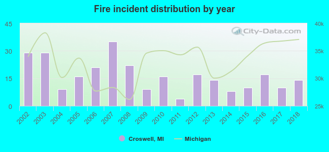 Based on the data from the years 2002 - 2018 the average number of fire incidents per year is 16. The highest number of fire incidents - 35 took place in 2007, and the least - 4 in 2011. The data has a decreasing trend.
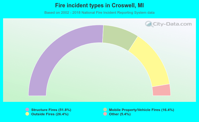 When looking into fire subcategories, the most reports belonged to: Structure Fires (51.8%), and Outside Fires (26.4%).
| Most common first names in Croswell, MI among deceased individuals | ||
| Name | Count | Lived (average) |
|---|---|---|
| John | 65 | 75.0 years |
| William | 55 | 79.1 years |
| Mary | 50 | 77.7 years |
| Robert | 34 | 69.2 years |
| Charles | 31 | 72.5 years |
| James | 24 | 74.1 years |
| Joseph | 22 | 76.7 years |
| Ruth | 20 | 81.0 years |
| Frank | 19 | 76.4 years |
| Harry | 18 | 70.8 years |
| Most common last names in Croswell, MI among deceased individuals | ||
| Last name | Count | Lived (average) |
|---|---|---|
| Smith | 16 | 74.8 years |
| Brown | 14 | 76.6 years |
| Hurley | 13 | 77.2 years |
| Gordon | 12 | 72.5 years |
| Gardner | 12 | 73.1 years |
| Todd | 10 | 78.5 years |
| Studaker | 10 | 78.4 years |
| Westbrook | 9 | 82.4 years |
| Hall | 9 | 74.8 years |
| Hunt | 9 | 82.6 years |
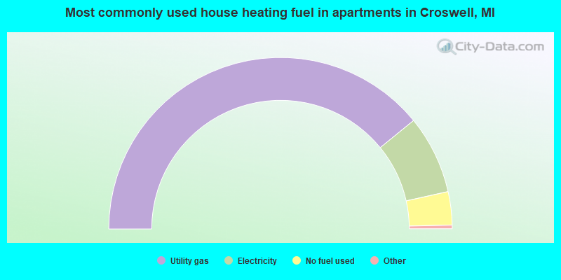
- 96.2%Utility gas
- 2.5%Electricity
- 1.3%Bottled, tank, or LP gas
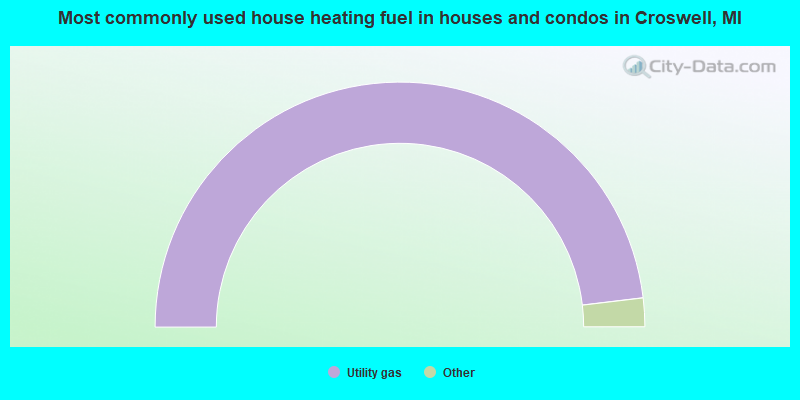
- 78.7%Utility gas
- 14.9%Electricity
- 6.3%No fuel used
Croswell compared to Michigan state average:
- Median house value below state average.
- Unemployed percentage below state average.
- Black race population percentage significantly below state average.
- Hispanic race population percentage above state average.
- Foreign-born population percentage significantly below state average.
- Length of stay since moving in significantly above state average.
- Number of college students below state average.
- Percentage of population with a bachelor's degree or higher below state average.

|
Total of 9 patent applications in 2008-2024.