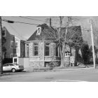
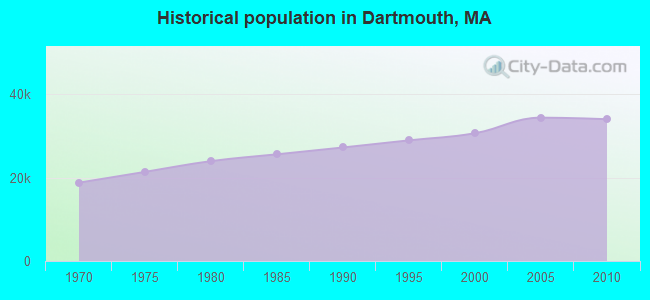
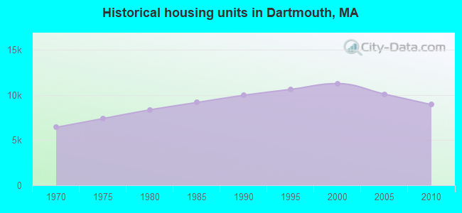
Dartmouth, Massachusetts

Dartmouth: Photograph taken from the Dartmouth landing of the Slocum River
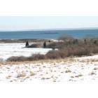
Dartmouth: Winter View of Allens Pond Sanctuary - Dartmouth,MA

Dartmouth: LIttle River Bridge Area South Dartmouth

Dartmouth: CLOUDY, FOGGY, DRIZZLY DAY ON THE PADANARAM HARBOR
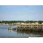
Dartmouth: PADANARAM
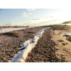
Dartmouth: little river beach snow strip
Dartmouth: LOW TIDE IN PADANARAM HARBOR
Dartmouth: The old Southworth Library on Elm St Padanaram
Dartmouth: Town Hall the old DHS

Dartmouth: ONE OF THE MARSHES ON SMITHNECK RD

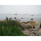
Dartmouth: Panoramic of Little Beach - Dartmouth,MA
- see
15
more - add
your
Submit your own pictures of this town and show them to the world
- OSM Map
- Google Map
- MSN Map
Population change since 2000: +11.0%
 |
| Males: 17,106 | |
| Females: 16,926 |
| Median resident age: | 39.6 years |
| Massachusetts median age: | 39.2 years |
Zip codes: 02747.
| Dartmouth: | $95,137 |
| MA: | $94,488 |
Estimated per capita income in 2022: $49,603 (it was $24,326 in 2000)
Dartmouth town income, earnings, and wages data
Estimated median house or condo value in 2022: $461,074 (it was $157,000 in 2000)
| Dartmouth: | $461,074 |
| MA: | $534,700 |
Mean prices in 2022: all housing units: $449,660; detached houses: $484,124; townhouses or other attached units: $382,766; in 2-unit structures: $322,469; in 3-to-4-unit structures: $355,875; in 5-or-more-unit structures: $269,714; mobile homes: $156,871; occupied boats, rvs, vans, etc.: $49,834
Detailed information about poverty and poor residents in Dartmouth, MA


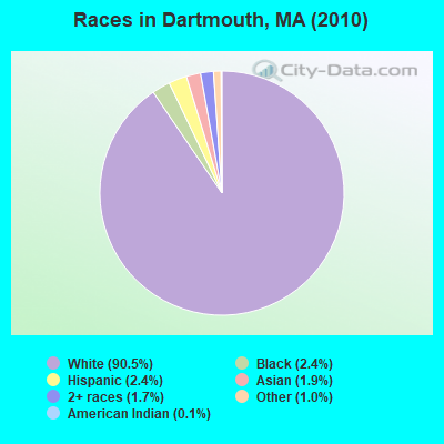
- 30,80290.5%White alone
- 8242.4%Black alone
- 8052.4%Hispanic
- 6421.9%Asian alone
- 5791.7%Two or more races
- 3261.0%Other race alone
- 480.1%American Indian alone
- 60.02%Native Hawaiian and Other
Pacific Islander alone
Races in Dartmouth detailed stats: ancestries, foreign born residents, place of birth
According to our research of Massachusetts and other state lists, there were 7 registered sex offenders living in Dartmouth, Massachusetts as of April 27, 2024.
The ratio of all residents to sex offenders in Dartmouth is 4,862 to 1.
The ratio of registered sex offenders to all residents in this city is much lower than the state average.
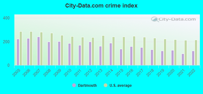
Type |
2009 |
2010 |
2011 |
2012 |
2013 |
2014 |
2015 |
2016 |
2017 |
2018 |
2019 |
2020 |
2021 |
2022 |
|---|---|---|---|---|---|---|---|---|---|---|---|---|---|---|
| Murders (per 100,000) | 0 (0.0) | 0 (0.0) | 0 (0.0) | 0 (0.0) | 0 (0.0) | 1 (2.9) | 0 (0.0) | 0 (0.0) | 0 (0.0) | 2 (5.8) | 0 (0.0) | 1 (2.9) | 0 (0.0) | 0 (0.0) |
| Rapes (per 100,000) | 4 (11.5) | 6 (17.6) | 2 (5.8) | 9 (26.2) | 5 (14.5) | 10 (28.8) | 2 (5.8) | 6 (17.3) | 8 (23.0) | 12 (35.0) | 4 (11.8) | 12 (35.3) | 6 (17.6) | 8 (23.4) |
| Robberies (per 100,000) | 13 (37.3) | 13 (38.2) | 17 (49.7) | 11 (32.0) | 9 (26.0) | 13 (37.5) | 11 (31.9) | 7 (20.2) | 11 (31.6) | 5 (14.6) | 16 (47.0) | 12 (35.3) | 8 (23.4) | 12 (35.1) |
| Assaults (per 100,000) | 73 (209.3) | 48 (141.0) | 49 (143.1) | 53 (154.2) | 35 (101.3) | 48 (138.3) | 43 (124.9) | 59 (170.4) | 54 (155.2) | 47 (136.9) | 57 (167.5) | 48 (141.2) | 43 (125.9) | 70 (204.7) |
| Burglaries (per 100,000) | 146 (418.6) | 142 (417.3) | 159 (464.4) | 193 (561.6) | 157 (454.3) | 125 (360.2) | 92 (267.1) | 99 (285.9) | 87 (250.0) | 55 (160.2) | 41 (120.5) | 37 (108.9) | 39 (114.2) | 35 (102.4) |
| Thefts (per 100,000) | 890 (2,552) | 819 (2,407) | 688 (2,009) | 802 (2,334) | 732 (2,118) | 766 (2,207) | 633 (1,838) | 678 (1,958) | 581 (1,669) | 384 (1,119) | 448 (1,316) | 349 (1,027) | 360 (1,054) | 364 (1,065) |
| Auto thefts (per 100,000) | 38 (108.9) | 34 (99.9) | 34 (99.3) | 16 (46.6) | 25 (72.3) | 31 (89.3) | 24 (69.7) | 27 (78.0) | 39 (112.1) | 20 (58.3) | 18 (52.9) | 21 (61.8) | 10 (29.3) | 9 (26.3) |
| Arson (per 100,000) | 6 (17.2) | 2 (5.9) | 4 (11.7) | 2 (5.8) | 1 (2.9) | 1 (2.9) | 0 (0.0) | 0 (0.0) | 5 (14.4) | 1 (2.9) | 1 (2.9) | 1 (2.9) | 0 (0.0) | 2 (5.8) |
| City-Data.com crime index | 202.3 | 187.2 | 169.0 | 197.8 | 161.9 | 188.4 | 137.0 | 158.6 | 152.1 | 132.0 | 122.3 | 126.6 | 98.7 | 122.0 |
The City-Data.com crime index weighs serious crimes and violent crimes more heavily. Higher means more crime, U.S. average is 246.1. It adjusts for the number of visitors and daily workers commuting into cities.
Crime rate in Dartmouth detailed stats: murders, rapes, robberies, assaults, burglaries, thefts, arson
Full-time law enforcement employees in 2020, including police officers: 86 (71 officers - 67 male; 4 female).
| Officers per 1,000 residents here: | 2.09 |
| Massachusetts average: | 2.59 |
 Recent articles from our blog. Our writers, many of them Ph.D. graduates or candidates, create easy-to-read articles on a wide variety of topics.
Ancestries: Portuguese (40.5%), Irish (12.2%), English (11.1%), French (9.2%), French Canadian (5.0%), Italian (4.7%).
Current Local Time: EST time zone
Incorporated in 1664
Land area: 61.6 square miles.
Population density: 553 people per square mile (low).
4,072 residents are foreign born (10.8% Europe).
| This town: | 13.3% |
| Massachusetts: | 12.2% |
| Dartmouth town: | 1.1% ($1,668) |
| Massachusetts: | 1.3% ($2,336) |
Nearest city with pop. 50,000+: New Bedford, MA  (3.2 miles , pop. 93,768).
Nearest city with pop. 200,000+: Boston, MA (49.3 miles , pop. 589,141).
Nearest city with pop. 1,000,000+: Bronx, NY (160.1 miles , pop. 1,332,650).
Nearest cities:
), ), )Latitude: 41.61 N, Longitude: 70.97 W
Dartmouth tourist attractions:
Dartmouth, Massachusetts accommodation & food services, waste management - Economy and Business Data
Single-family new house construction building permits:
- 2022: 33 buildings, average cost: $371,500
- 2021: 32 buildings, average cost: $325,300
- 2020: 27 buildings, average cost: $351,600
- 2019: 43 buildings, average cost: $392,000
- 2018: 51 buildings, average cost: $294,900
- 2017: 75 buildings, average cost: $314,500
- 2016: 73 buildings, average cost: $317,100
- 2015: 59 buildings, average cost: $314,000
- 2014: 60 buildings, average cost: $282,800
- 2013: 31 buildings, average cost: $232,700
- 2012: 31 buildings, average cost: $414,300
- 2011: 36 buildings, average cost: $389,900
- 2010: 40 buildings, average cost: $277,200
- 2009: 27 buildings, average cost: $296,300
- 2008: 28 buildings, average cost: $348,400
- 2007: 54 buildings, average cost: $349,200
- 2006: 68 buildings, average cost: $256,700
- 2005: 81 buildings, average cost: $243,000
- 2004: 100 buildings, average cost: $299,800
- 2003: 136 buildings, average cost: $137,200
- 2002: 142 buildings, average cost: $137,200
- 2001: 134 buildings, average cost: $137,200
- 2000: 150 buildings, average cost: $137,300
- 1999: 143 buildings, average cost: $110,000
- 1998: 144 buildings, average cost: $110,000
- 1997: 131 buildings, average cost: $110,000
| Here: | 3.7% |
| Massachusetts: | 3.5% |
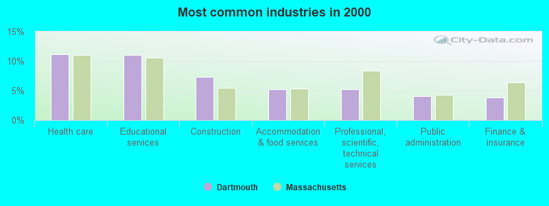
- Health care (11.2%)
- Educational services (11.0%)
- Construction (7.4%)
- Accommodation & food services (5.2%)
- Professional, scientific, technical services (5.2%)
- Public administration (4.0%)
- Finance & insurance (3.8%)
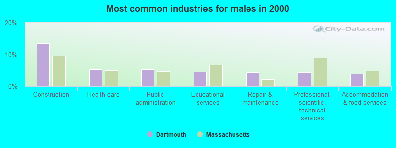
- Construction (13.5%)
- Health care (5.5%)
- Public administration (5.4%)
- Educational services (4.7%)
- Repair & maintenance (4.5%)
- Professional, scientific, technical services (4.5%)
- Accommodation & food services (4.1%)
- Educational services (17.4%)
- Health care (17.0%)
- Accommodation & food services (6.5%)
- Professional, scientific, technical services (6.0%)
- Department & other general merchandise stores (4.5%)
- Finance & insurance (4.4%)
- Social assistance (3.9%)
- Other production occupations, including supervisors (4.4%)
- Other management occupations, except farmers and farm managers (4.2%)
- Other office and administrative support workers, including supervisors (4.1%)
- Other sales and related occupations, including supervisors (3.9%)
- Retail sales workers, except cashiers (3.6%)
- Preschool, kindergarten, elementary, and middle school teachers (3.4%)
- Secretaries and administrative assistants (3.3%)
- Other production occupations, including supervisors (5.9%)
- Other sales and related occupations, including supervisors (5.4%)
- Other management occupations, except farmers and farm managers (4.9%)
- Electrical equipment mechanics and other installation, maintenance, and repair workers, including supervisors (4.7%)
- Vehicle and mobile equipment mechanics, installers, and repairers (4.6%)
- Carpenters (4.3%)
- Driver/sales workers and truck drivers (3.2%)
- Other office and administrative support workers, including supervisors (6.7%)
- Secretaries and administrative assistants (6.4%)
- Preschool, kindergarten, elementary, and middle school teachers (5.6%)
- Retail sales workers, except cashiers (4.4%)
- Other management occupations, except farmers and farm managers (3.5%)
- Bookkeeping, accounting, and auditing clerks (3.3%)
- Cashiers (3.3%)
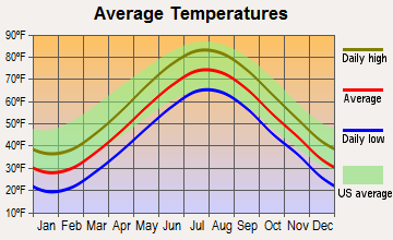
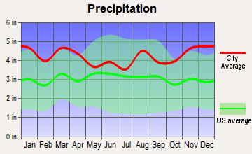
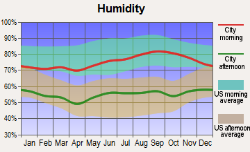
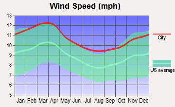
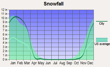
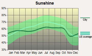
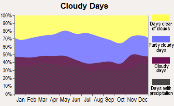
Average climate in Dartmouth, Massachusetts
Based on data reported by over 4,000 weather stations
(lower is better)
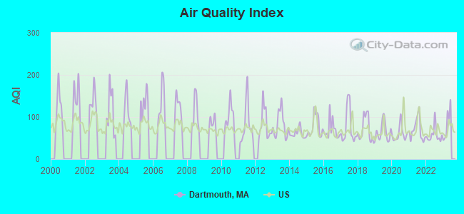
Air Quality Index (AQI) level in 2022 was 56.9. This is better than average.
| City: | 56.9 |
| U.S.: | 72.6 |
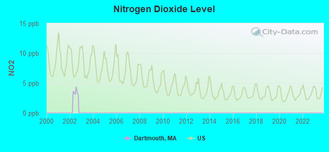
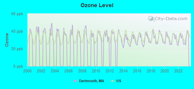
Ozone [ppb] level in 2022 was 30.7. This is about average. Closest monitor was 3.6 miles away from the city center.
| City: | 30.7 |
| U.S.: | 33.3 |
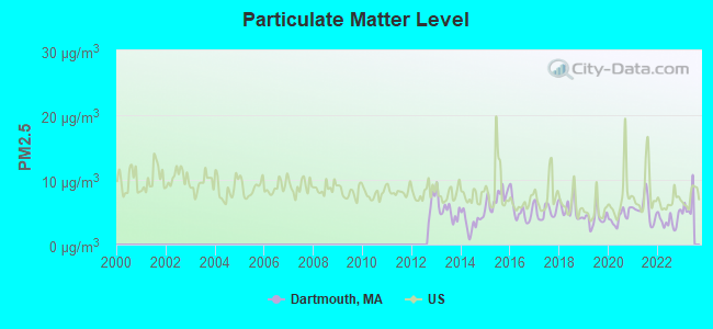
Particulate Matter (PM2.5) [µg/m3] level in 2022 was 3.74. This is significantly better than average. Closest monitor was 2.5 miles away from the city center.
| City: | 3.74 |
| U.S.: | 8.11 |
Tornado activity:
Dartmouth-area historical tornado activity is significantly below Massachusetts state average. It is 72% smaller than the overall U.S. average.
On 6/9/1953, a category F3 (max. wind speeds 158-206 mph) tornado 32.4 miles away from the Dartmouth town center injured 17 people and caused between $500,000 and $5,000,000 in damages.
On 8/28/1970, a category F2 (max. wind speeds 113-157 mph) tornado 3.7 miles away from the town center caused between $5000 and $50,000 in damages.
Earthquake activity:
Dartmouth-area historical earthquake activity is significantly above Massachusetts state average. It is 75% smaller than the overall U.S. average.On 10/7/1983 at 10:18:46, a magnitude 5.3 (5.1 MB, 5.3 LG, 5.1 ML, Class: Moderate, Intensity: VI - VII) earthquake occurred 235.5 miles away from the city center
On 4/20/2002 at 10:50:47, a magnitude 5.3 (5.3 ML, Depth: 3.0 mi) earthquake occurred 243.2 miles away from the city center
On 1/19/1982 at 00:14:42, a magnitude 4.7 (4.5 MB, 4.7 MD, 4.5 LG, Class: Light, Intensity: IV - V) earthquake occurred 134.3 miles away from the city center
On 10/16/2012 at 23:12:25, a magnitude 4.7 (4.7 ML, Depth: 10.0 mi) earthquake occurred 138.1 miles away from the city center
On 4/20/2002 at 10:50:47, a magnitude 5.2 (5.2 MB, 4.2 MS, 5.2 MW, 5.0 MW) earthquake occurred 242.4 miles away from Dartmouth center
On 8/22/1992 at 12:20:32, a magnitude 4.8 (4.8 MB, 3.8 MS, 4.7 LG, Depth: 6.2 mi) earthquake occurred 176.9 miles away from the city center
Magnitude types: regional Lg-wave magnitude (LG), body-wave magnitude (MB), duration magnitude (MD), local magnitude (ML), surface-wave magnitude (MS), moment magnitude (MW)
Natural disasters:
The number of natural disasters in Bristol County (23) is greater than the US average (15).Major Disasters (Presidential) Declared: 12
Emergencies Declared: 11
Causes of natural disasters: Floods: 8, Hurricanes: 7, Storms: 5, Snows: 3, Snowstorms: 3, Winter Storms: 3, Blizzards: 2, Explosion: 1, Heavy Rain: 1, Snowfall: 1, Tropical Storm: 1, Wind: 1 (Note: some incidents may be assigned to more than one category).
Hospitals and medical centers in Dartmouth:
Other hospitals and medical centers near Dartmouth:
- BRANDON WOODS L T C FACILITY (Nursing Home, about 2 miles away; SOUTH DARTMOUTH, MA)
- BRANDON WOODS OF DARTMOUTH (Nursing Home, about 2 miles away; SOUTH DARTMOUTH, MA)
- NEW BEDFORD JEWISH CONVALESCENT HOME, INC (Nursing Home, about 2 miles away; NEW BEDFORD, MA)
- ROYAL TABER STREET NURS AND REHAB CTR (Nursing Home, about 2 miles away; NEW BEDFORD, MA)
- HALLMARK NURSING HOME OF NEW BEDFORD (Nursing Home, about 3 miles away; NEW BEDFORD, MA)
- KINDRED NURSING AND REHABILITATION-HALLMARK (Nursing Home, about 3 miles away; NEW BEDFORD, MA)
- HATHAWAY MANOR EXTENDED CARE (Nursing Home, about 3 miles away; NEW BEDFORD, MA)
Colleges/universities with over 2000 students nearest to Dartmouth:
- University of Massachusetts-Dartmouth (about 3 miles; North Dartmouth, MA; Full-time enrollment: 7,545)
- Bristol Community College (about 11 miles; Fall River, MA; FT enrollment: 5,707)
- Roger Williams University (about 16 miles; Bristol, RI; FT enrollment: 4,375)
- Salve Regina University (about 20 miles; Newport, RI; FT enrollment: 2,349)
- Bridgewater State University (about 26 miles; Bridgewater, MA; FT enrollment: 9,802)
- Brown University (about 27 miles; Providence, RI; FT enrollment: 8,458)
- Rhode Island School of Design (about 27 miles; Providence, RI; FT enrollment: 2,714)
Public high school in Dartmouth:
- DARTMOUTH HIGH (Students: 13, Location: 555 BAKERVILLE ROAD, Grades: 9-12)
Public elementary/middle school in Dartmouth:
- JAMES M. QUINN SCHOOL (Students: 653, Location: 529 HAWTHORN STREET, Grades: KG-5)
Library in Dartmouth:
- DARTMOUTH PUBLIC LIBRARIES (Operating income: $962,617; Location: 732 DARTMOUTH STREET; 92,516 books; 523 e-books; 3,897 audio materials; 6,578 video materials; 2 local licensed databases; 34 state licensed databases; 1 other licensed databases; 86 print serial subscriptions; 2 electronic serial subscriptions)
Points of interest:
Notable locations in Dartmouth: New Bedford Rod and Gun Club (A), Hawthorne Country Club (B), Allendale Country Club (C), New Bedford Country Club (D), New Bedford City Rifle Range (E), Southcoast EMS (F), Dartmouth Fire Department District 2 (G), Dartmouth Fire Department District 3 Station 1 Headquarters (H), Dartmouth Fire Department District 1 Station 1 Headquarters (I), Dartmouth Fire Department District 3 Station 2 (J), Dartmouth Fire Department District 3 Station 3 (K), Roseanne Barker Library and Media Center (L), Doll Museum (M). Display/hide their locations on the map
Shopping Center: North Dartmouth Mall (1). Display/hide its location on the map
Churches in Dartmouth include: Holy Ghost Church (A), Smith Neck Church (B), Apponagansett Church (C), Saint George Church (D). Display/hide their locations on the map
Cemeteries: Evergreen Cemetery (1), Pine Island Cemetery (2), Davis Cemetery (3), Hill Meadow Cemetery (4). Display/hide their locations on the map
Lakes, reservoirs, and swamps: Cedar Dell Lake (A), Allens Pond (B), Georges Pond (C), High Hill Reservoir (D), Cornell Pond (E), Noquochoke Lake (F), Shingle Island Swamp (G), Deerfield Swamp (H). Display/hide their locations on the map
Streams, rivers, and creeks: Shingle Island River (A), Destruction Brook (B), Copicut River (C), Castle Brook (D), Paskamanset River (E), Buttonwood Brook (F). Display/hide their locations on the map
Parks in Dartmouth include: Demarest Lloyd Memorial State Park (1), Apponagansett Point Recreation Area (2), Jones Park (3). Display/hide their locations on the map
Beach: Little Beach (A). Display/hide its location on the map
Tourist attraction: Allens Pond Wildlife Sanctuary (Recreation Areas; 1280 Horseneck Road) (1). Display/hide its approximate location on the map
Birthplace of: Benjamin Tucker - Anarchist, Henry H. Crapo - Politician, John George, Jr. - Politician, William W. Crapo - Politician.
Drinking water stations with addresses in Dartmouth and their reported violations in the past:
DARTMOUTH WATER DIVISION (Population served: 23,492, Purch surface water):Past health violations:
- MCL, Average - Between JUL-2013 and SEP-2013, Contaminant: TTHM. Follow-up actions: St AO (w/o penalty) issued (MAR-18-2014)
- MCL, Monthly (TCR) - In NOV-2010, Contaminant: Coliform. Follow-up actions: St AO (w/o penalty) issued (FEB-18-2011), St Compliance achieved (FEB-18-2011)
- MCL, Monthly (TCR) - In OCT-2010, Contaminant: Coliform. Follow-up actions: St AO (w/o penalty) issued (FEB-10-2011), St Compliance achieved (FEB-10-2011)
- MCL, Monthly (TCR) - In DEC-2009, Contaminant: Coliform. Follow-up actions: St AO (w/o penalty) issued (FEB-25-2010), St Compliance achieved (FEB-25-2010)
| This town: | 2.5 people |
| Massachusetts: | 2.5 people |
| This town: | 71.3% |
| Whole state: | 63.0% |
| This town: | 6.0% |
| Whole state: | 7.0% |
Likely homosexual households (counted as self-reported same-sex unmarried-partner households)
- Lesbian couples: 0.4% of all households
- Gay men: 0.2% of all households
| This town: | 4.5% |
| Whole state: | 9.3% |
| This town: | 1.5% |
| Whole state: | 4.4% |
People in group quarters in Dartmouth in 2010:
- 4,130 people in college/university student housing
- 1,133 people in local jails and other municipal confinement facilities
- 161 people in nursing facilities/skilled-nursing facilities
- 25 people in residential treatment centers for adults
- 15 people in group homes intended for adults
- 11 people in other noninstitutional facilities
People in group quarters in Dartmouth in 2000:
- 2,157 people in college dormitories (includes college quarters off campus)
- 842 people in local jails and other confinement facilities (including police lockups)
- 151 people in nursing homes
- 19 people in religious group quarters
- 16 people in homes for the mentally retarded
- 15 people in other noninstitutional group quarters
- 9 people in other nonhousehold living situations
Banks with branches in Dartmouth (2011 data):
- Bristol County Savings Bank: Dartmouth Branch at 502 State Road, branch established on 2007/01/08. Info updated 2007/09/11: Bank assets: $1,338.8 mil, Deposits: $1,027.4 mil, headquarters in Taunton, MA, positive income, Commercial Lending Specialization, 13 total offices, Holding Company: Beacon Bancorp
- BankFive: Dartmouth Branch at 136 Faunce Corner Mall Road, branch established on 1998/12/15. Info updated 2011/11/15: Bank assets: $720.6 mil, Deposits: $613.3 mil, headquarters in Fall River, MA, positive income, Commercial Lending Specialization, 13 total offices, Holding Company: Bankfive, Mhc
- Sovereign Bank, National Association: Dartmouth Mall Branch at 88-90 North Dartmouth Mall #90, branch established on 1971/04/13. Info updated 2012/01/31: Bank assets: $78,146.9 mil, Deposits: $48,042.9 mil, headquarters in Wilmington, DE, positive income, Commercial Lending Specialization, 718 total offices, Holding Company: Banco Santander, S.A.
- RBS Citizens, National Association: Dartmouth Stop & Shop Branch at 25 Faunce Corner Mall Road, branch established on 2001/12/12. Info updated 2007/09/19: Bank assets: $106,940.6 mil, Deposits: $75,690.2 mil, headquarters in Providence, RI, positive income, 1135 total offices, Holding Company: Uk Financial Investments Limited
For population 15 years and over in Dartmouth:
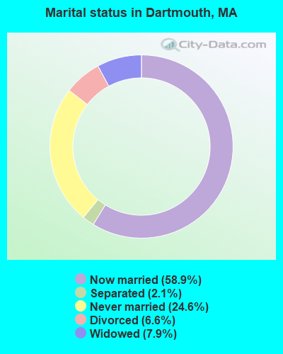
- Never married: 24.6%
- Now married: 58.9%
- Separated: 2.1%
- Widowed: 7.9%
- Divorced: 6.6%
For population 25 years and over in Dartmouth:
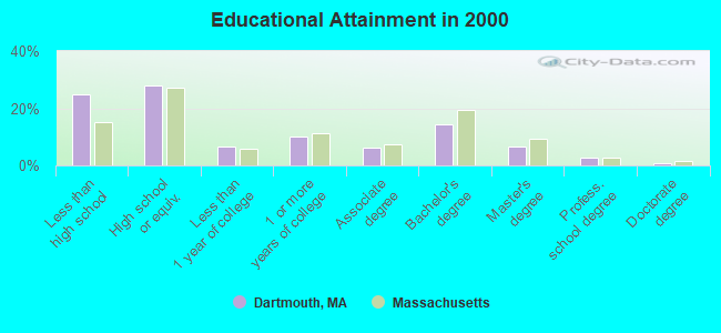
- High school or higher: 75.3%
- Bachelor's degree or higher: 24.6%
- Graduate or professional degree: 10.2%
- Unemployed: 12.0%
- Mean travel time to work (commute): 24.4 minutes
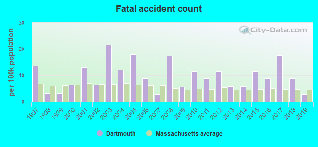
| Here: | 15.7 |
| Massachusetts average: | 13.1 |
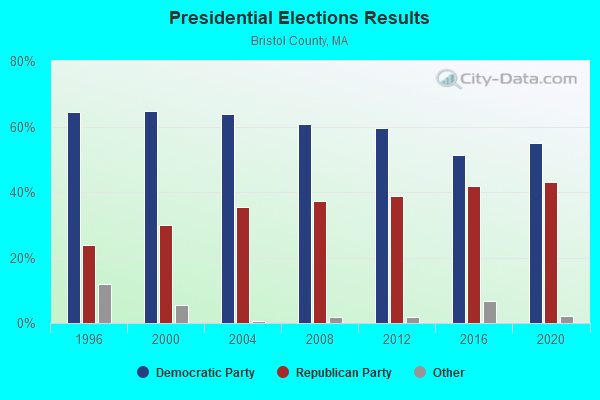
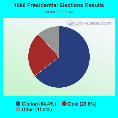
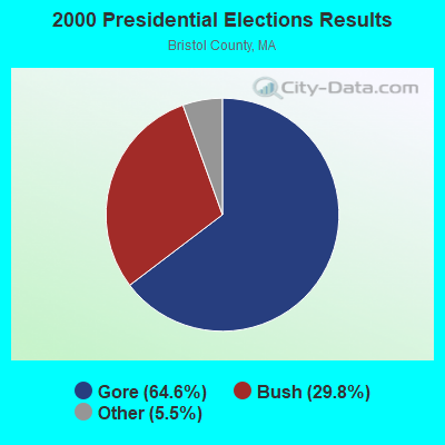
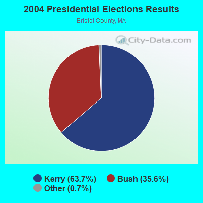
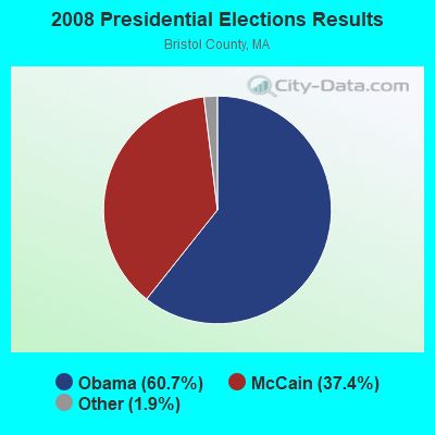
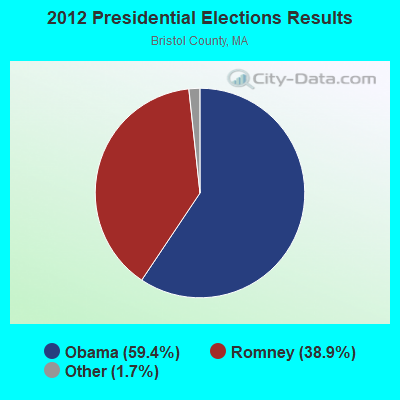

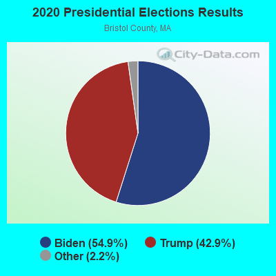
Graphs represent county-level data. Detailed 2008 Election Results
Religion statistics for Dartmouth, MA (based on Bristol County data)
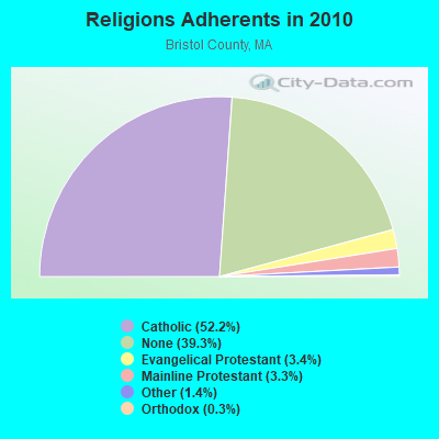
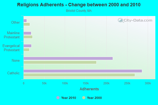
| Religion | Adherents | Congregations |
|---|---|---|
| Catholic | 286,113 | 72 |
| Evangelical Protestant | 18,765 | 128 |
| Mainline Protestant | 18,246 | 83 |
| Other | 7,807 | 33 |
| Orthodox | 1,565 | 4 |
| Black Protestant | 511 | 5 |
| None | 215,278 | - |
Food Environment Statistics:
| Bristol County: | 2.00 / 10,000 pop. |
| Massachusetts: | 1.98 / 10,000 pop. |
| Bristol County: | 0.09 / 10,000 pop. |
| Massachusetts: | 0.05 / 10,000 pop. |
| Bristol County: | 1.93 / 10,000 pop. |
| State: | 2.22 / 10,000 pop. |
| Bristol County: | 2.35 / 10,000 pop. |
| Massachusetts: | 1.77 / 10,000 pop. |
| Bristol County: | 8.20 / 10,000 pop. |
| Massachusetts: | 8.76 / 10,000 pop. |
| Bristol County: | 9.5% |
| State: | 8.1% |
| Bristol County: | 26.9% |
| Massachusetts: | 22.5% |
| This county: | 14.4% |
| Massachusetts: | 16.5% |
4.76% of this county's 2021 resident taxpayers lived in other counties in 2020 ($70,162 average adjusted gross income)
| Here: | 4.76% |
| Massachusetts average: | 6.35% |
0.01% of residents moved from foreign countries ($64 average AGI)
Bristol County: 0.01% Massachusetts average: 0.01%
Top counties from which taxpayers relocated into this county between 2020 and 2021:
| from Plymouth County, MA | |
| from Norfolk County, MA | |
| from Providence County, RI |
4.63% of this county's 2020 resident taxpayers moved to other counties in 2021 ($72,404 average adjusted gross income)
| Here: | 4.63% |
| Massachusetts average: | 7.18% |
0.01% of residents moved to foreign countries ($83 average AGI)
Bristol County: 0.01% Massachusetts average: 0.02%
Top counties to which taxpayers relocated from this county between 2020 and 2021:
| to Plymouth County, MA | |
| to Providence County, RI | |
| to Norfolk County, MA |
| Businesses in Dartmouth, MA | ||||
| Name | Count | Name | Count | |
|---|---|---|---|---|
| Ace Hardware | 1 | Nike | 3 | |
| Cold Stone Creamery | 1 | Pac Sun | 1 | |
| Dunkin Donuts | 4 | Ruby Tuesday | 1 | |
| Finish Line | 1 | Shaw's | 1 | |
| Hollister Co. | 1 | Spencer Gifts | 1 | |
| Honda | 1 | Stop & Shop | 1 | |
| Hot Topic | 1 | Subway | 1 | |
| Journeys | 1 | T-Mobile | 1 | |
| Justice | 1 | Verizon Wireless | 2 | |
| Kohl's | 1 | Victoria's Secret | 1 | |
| MasterBrand Cabinets | 2 | YMCA | 1 | |
| Motherhood Maternity | 1 | |||
Strongest AM radio stations in Dartmouth:
- WBSM (1420 AM; 5 kW; NEW BEDFORD, MA; Owner: CITADEL BROADCASTING COMPANY)
- WNBH (1340 AM; 1 kW; NEW BEDFORD, MA; Owner: HALL COMMUNICATIONS INC.)
- WALE (990 AM; 50 kW; GREENVILLE, RI; Owner: NORTH AMERICAN BROADCASTING CO., INC.)
- WEEI (850 AM; 50 kW; BOSTON, MA; Owner: ENTERCOM BOSTON LICENSE, LLC)
- WBZ (1030 AM; 50 kW; BOSTON, MA; Owner: INFINITY BROADCASTING OPERATIONS, INC.)
- WSAR (1480 AM; 5 kW; FALL RIVER, MA; Owner: BRISTOL COUNTY BROADCASTING, INC.)
- WRKO (680 AM; 50 kW; BOSTON, MA; Owner: ENTERCOM BOSTON LICENSE, LLC)
- WPRO (630 AM; 5 kW; PROVIDENCE, RI; Owner: CITADEL BROADCASTING COMPANY)
- WKOX (1200 AM; 50 kW; FRAMINGHAM, MA; Owner: CAPSTAR TX LIMITED PARTNERSHIP)
- WBIX (1060 AM; 40 kW; NATICK, MA; Owner: LANGER BROADCASTING CORPORATION)
- WCRN (830 AM; 50 kW; WORCESTER, MA; Owner: CARTER BROADCASTING CORPORATION)
- WWZN (1510 AM; 50 kW; BOSTON, MA; Owner: ROSE CITY RADIO CORPORATION)
- WAMG (890 AM; 25 kW; DEDHAM, MA; Owner: MEGA COMMUNICATIONS OF DEDHAM LICENSEE, LLC)
Strongest FM radio stations in Dartmouth:
- WCTK (98.1 FM; NEW BEDFORD, MA; Owner: HALL COMMUNICATIONS, INC.)
- WSMU-FM (91.1 FM; NORTH DARTMOUTH, MA; Owner: UNIVERSITY OF MASSACHUSETTS)
- WFHN (107.1 FM; FAIRHAVEN, MA; Owner: CITADEL BROADCASTING COMPANY)
- WJFD-FM (97.3 FM; NEW BEDFORD, MA; Owner: EDMUND DINIS, TRUSTEE)
- WKKB (100.3 FM; MIDDLETOWN, RI; Owner: CITADEL BROADCASTING COMPANY)
- WFHL (88.1 FM; NEW BEDFORD, MA; Owner: NEW BEDFORD CHRISTIAN RADIO, INC.)
- WWBB (101.5 FM; PROVIDENCE, RI; Owner: CLEAR CHANNEL BROADCASTING LICENSES, INC.)
- WCIB (101.9 FM; FALMOUTH, MA; Owner: QANTUM OF CAPE COD LICENSE COMPANY, LLC)
- WSNE-FM (93.3 FM; TAUNTON, MA; Owner: CAPSTAR TX LIMITED PARTNERSHIP)
- WBRU (95.5 FM; PROVIDENCE, RI; Owner: BROWN BROADCASTING SERVICE, INC.)
- WPRO-FM (92.3 FM; PROVIDENCE, RI; Owner: CITADEL BROADCASTING COMPANY)
- WHJY (94.1 FM; PROVIDENCE, RI; Owner: CAPSTAR TX LIMITED PARTNERSHIP)
- WTWV (101.1 FM; MASHPEE, MA; Owner: BOCH BROADCASTING, L.P.)
- WWLI (105.1 FM; PROVIDENCE, RI; Owner: CITADEL BROADCASTING COMPANY)
- WCAI (90.1 FM; WOODS HOLE, MA; Owner: WGBH EDUCATIONAL FOUNDATION)
- WMVY (92.7 FM; TISBURY, MA; Owner: ARITAUR COMMUNICATIONS, INC.)
- WBOT (97.7 FM; BROCKTON, MA; Owner: RADIO ONE LICENSES, LLC)
- WPLM-FM (99.1 FM; PLYMOUTH, MA; Owner: PLYMOUTH ROCK BROADCASTING CO., INC.)
- WFPB-FM (91.9 FM; FALMOUTH, MA; Owner: UNIVERSITY OF MASSACHUSETTS)
TV broadcast stations around Dartmouth:
- WLWC (Channel 28; NEW BEDFORD, MA; Owner: C-28 FCC LICENSEE SUBSIDIARY, LLC)
- WLNE-TV (Channel 6; NEW BEDFORD, MA; Owner: FREEDOM BROADCASTING OF SOUTHERN NEW ENGLAND, INC.)
- WNAC-TV (Channel 64; PROVIDENCE, RI; Owner: WNAC, LLC)
- WPRI-TV (Channel 12; PROVIDENCE, RI; Owner: TVL BROADCASTING OF RHODE ISLAND, LLC)
- WJAR (Channel 10; PROVIDENCE, RI; Owner: OUTLET BROADCASTING, INC.)
- WWDP (Channel 46; NORWELL, MA; Owner: NORWELL TELEVISION, LLC)
- WSBE-TV (Channel 36; PROVIDENCE, RI; Owner: RHODE ISLAND PUBLIC TELECOM. AUTHORITY)
- WPXQ (Channel 69; BLOCK ISLAND, RI; Owner: OCEAN STATE TELEVISION, L.L.C.)
- WCVB-TV (Channel 5; BOSTON, MA; Owner: WCVB HEARST-ARGYLE TV, INC.)
- WMFP (Channel 62; LAWRENCE, MA; Owner: WSAH LICENSE, INC.)
- WSBK-TV (Channel 38; BOSTON, MA; Owner: VIACOM INC.)
- WLVI-TV (Channel 56; CAMBRIDGE, MA; Owner: WLVI, INC.)
- WBZ-TV (Channel 4; BOSTON, MA; Owner: VIACOM INC.)
- WGBX-TV (Channel 44; BOSTON, MA; Owner: WGBH EDUCATIONAL FOUNDATION)
Medal of Honor Recipients
Medal of Honor Recipient born in Dartmouth: David L. Gifford.
- National Bridge Inventory (NBI) Statistics
- 18Number of bridges
- 187ft / 57.2mTotal length
- $33,159,000Total costs
- 308,486Total average daily traffic
- 8,170Total average daily truck traffic
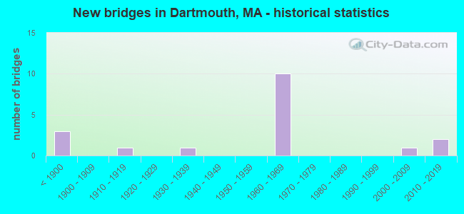
- New bridges - historical statistics
- 3Before 1900
- 11910-1919
- 11930-1939
- 101960-1969
- 12000-2009
- 22010-2019
FCC Registered Cell Phone Towers:
2 (See the full list of FCC Registered Cell Phone Towers in Dartmouth)FCC Registered Antenna Towers:
24 (See the full list of FCC Registered Antenna Towers)FCC Registered Broadcast Land Mobile Towers:
13 (See the full list of FCC Registered Broadcast Land Mobile Towers in Dartmouth, MA)FCC Registered Microwave Towers:
4- ROSE AUTO MA, 411 Faunce Corner Rd (091886) (Lat: 41.666167 Lon: -70.989500), Type: Pole, Structure height: 36.5 m, Overall height: 37.7 m, Call Sign: WQIM519,
Assigned Frequencies: 6256.54 MHz, Grant Date: 03/18/2008, Expiration Date: 03/18/2018, Cancellation Date: 09/18/2009, Certifier: William Chastain, Registrant: Radio Dynamics Corporation, Silver Spring, MD 20914, Phone: (301) 493-5171, Fax: (301) 576-4553, Email:
- UMass Dartmouth, 285 Old Westport Rd. North (Lat: 41.628611 Lon: -71.006167), Type: Bant, Structure height: 61 m, Overall height: 67.1 m, Call Sign: WRNP844,
Assigned Frequencies: 19425.0 MHz, 19375.0 MHz, Grant Date: 08/05/2021, Expiration Date: 08/05/2031, Certifier: Richard K Arruda, Registrant: Micronet Communications, Inc., 812 Lexington Dr, Plano, TX 75075, Phone: (972) 422-7200, Email:
- District 3 Head Qtrs, 140 Cross Road (Lat: 41.642611 Lon: -71.006194), Type: Tower, Structure height: 8.5 m, Overall height: 12.2 m, Call Sign: WRNP845,
Assigned Frequencies: 17865.0 MHz, Grant Date: 08/05/2021, Expiration Date: 08/05/2031, Certifier: Richard K Arruda, Registrant: Micronet Communications, Inc., 812 Lexington Dr, Plano, TX 75075, Phone: (972) 422-7200, Email:
- Old Fall River Road, Old Fall River (Lat: 41.680806 Lon: -71.002333), Type: Tank, Structure height: 31.7 m, Overall height: 33.5 m, Call Sign: WRNP874,
Assigned Frequencies: 17815.0 MHz, Grant Date: 08/05/2021, Expiration Date: 08/05/2031, Certifier: Richard K Arruda, Registrant: Micronet Communications, Inc., 812 Lexington Dr, Plano, TX 75075, Phone: (972) 422-7200, Email:
FCC Registered Amateur Radio Licenses:
39 (See the full list of FCC Registered Amateur Radio Licenses in Dartmouth)FAA Registered Aircraft:
14 (See the full list of FAA Registered Aircraft in Dartmouth)2005 - 2018 National Fire Incident Reporting System (NFIRS) incidents
- Fire incident types reported to NFIRS in Dartmouth, MA
- 78951.8%Outside Fires
- 39926.2%Structure Fires
- 22014.4%Mobile Property/Vehicle Fires
- 1167.6%Other
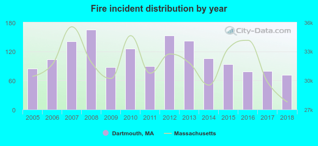 According to the data from the years 2005 - 2018 the average number of fire incidents per year is 108. The highest number of reported fires - 165 took place in 2008, and the least - 71 in 2018. The data has a declining trend.
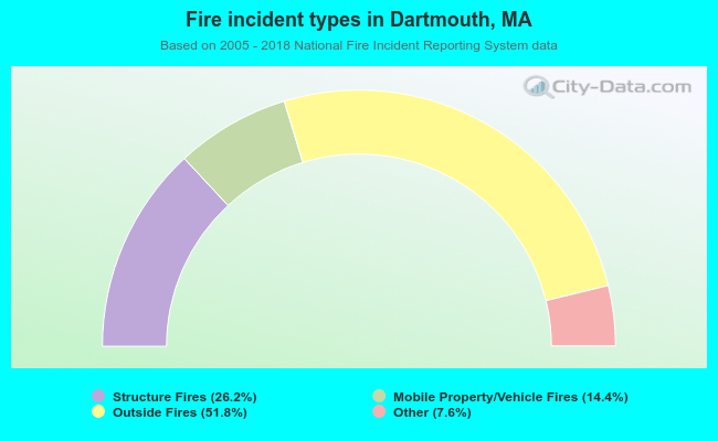 When looking into fire subcategories, the most reports belonged to: Outside Fires (51.8%), and Structure Fires (26.2%).
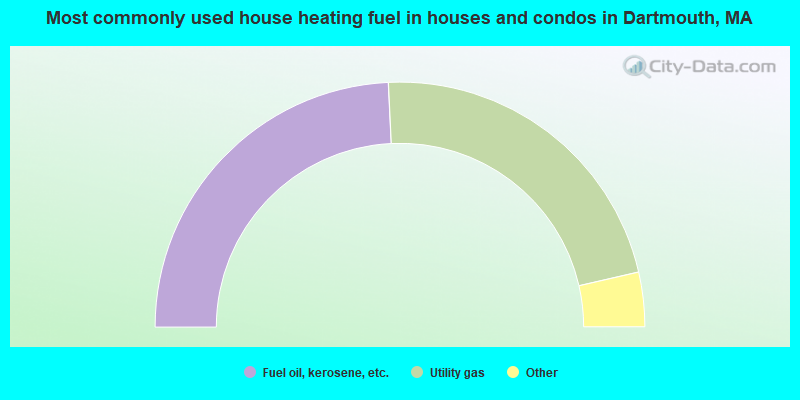
- 48.5%Fuel oil, kerosene, etc.
- 44.3%Utility gas
- 3.1%Bottled, tank, or LP gas
- 2.6%Electricity
- 1.5%Wood
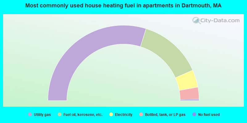
- 59.6%Utility gas
- 27.1%Fuel oil, kerosene, etc.
- 7.5%Electricity
- 5.2%Bottled, tank, or LP gas
- 0.5%No fuel used
Dartmouth compared to Massachusetts state average:
- Black race population percentage below state average.
- Hispanic race population percentage significantly below state average.
- Renting percentage below state average.
- Length of stay since moving in significantly above state average.
- Number of rooms per house significantly below state average.
- House age significantly below state average.
- Institutionalized population percentage above state average.
Dartmouth on our top lists:
- #33 on the list of "Top 101 cities with largest percentage of males in occupations: food processing workers (population 5,000+)"
- #47 on the list of "Top 101 cities with largest percentage of males in industries: alcoholic beverages merchant wholesalers (population 5,000+)"
- #53 on the list of "Top 101 cities with largest percentage of males in industries: miscellaneous manufacturing (population 5,000+)"
- #70 on the list of "Top 101 cities with largest percentage of females in industries: apparel (population 5,000+)"
- #71 on the list of "Top 101 cities with largest percentage of males in industries: apparel, fabrics, and notions merchant wholesalers (population 5,000+)"
- #73 on the list of "Top 101 cities with largest percentage of males in occupations: nursing, psychiatric, and home health aides (population 5,000+)"
- #81 on the list of "Top 101 cities with largest percentage of females in industries: water transportation (population 5,000+)"
- #83 on the list of "Top 101 cities with largest percentage of males in industries: retail florists (population 5,000+)"
- #85 on the list of "Top 101 cities with largest percentage of males in industries: textile mills and textile products (population 5,000+)"
- #86 on the list of "Top 101 cities with largest percentage of females in occupations: special education teachers (population 5,000+)"
- #90 on the list of "Top 101 cities with largest percentage of females in occupations: plant and system operators (population 5,000+)"
- #93 on the list of "Top 101 cities with largest percentage of females in industries: miscellaneous manufacturing (population 5,000+)"
- #95 on the list of "Top 101 cities with largest percentage of females in occupations: textile, apparel, and furnishings workers (population 5,000+)"
- #96 on the list of "Top 101 cities with largest percentage of females in industries: petroleum and coal products (population 5,000+)"
- #99 on the list of "Top 101 cities with largest percentage of females in occupations: occupational and physical therapist assistants and aides (population 5,000+)"
- #24 (02747) on the list of "Top 101 zip codes with the largest percentage of Portuguese first ancestries"
- #14 on the list of "Top 101 counties with the lowest percentage of residents that keep firearms around their homes"
- #29 on the list of "Top 101 counties with the lowest percentage of residents relocating to foreign countries in 2011 (pop. 50,000+)"
- #32 on the list of "Top 101 counties with the most Catholic congregations"
- #34 on the list of "Top 101 counties with the highest percentage of residents that smoked 100+ cigarettes in their lives"
- #41 on the list of "Top 101 counties with the most Catholic adherents"

|
|
Total of 129 patent applications in 2008-2024.