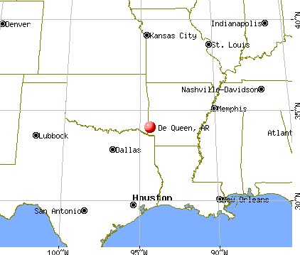
De Queen, Arkansas
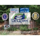
De Queen: De Queen Heart of Tri-Lakes Country
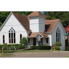
De Queen: First Presbyterian Church (Oldest church in Dueen)
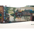
De Queen: Mural dedicated to local Indian heritage.
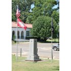
De Queen: Memorial to fallen soldiers from World War's I, II, Korean and Viernam.
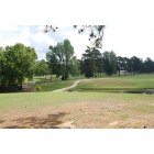
De Queen: De Queen's Golf Course & Country Club
- add
your
Submit your own pictures of this city and show them to the world
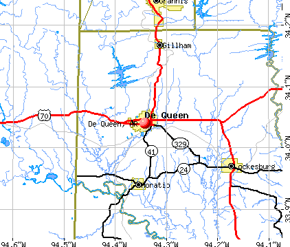
- OSM Map
- General Map
- Google Map
- MSN Map
Population change since 2000: +4.8%
 |
| Males: 2,759 | |
| Females: 3,283 |
| Median resident age: | 33.4 years |
| Arkansas median age: | 38.9 years |
Zip codes: 71832.
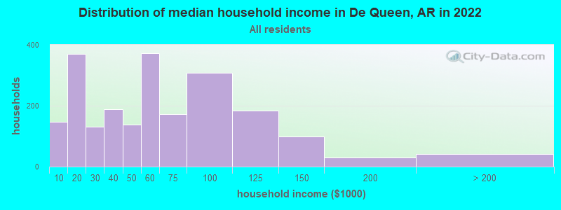
| De Queen: | $54,322 |
| AR: | $55,432 |
Estimated per capita income in 2022: $22,891 (it was $12,968 in 2000)
De Queen city income, earnings, and wages data
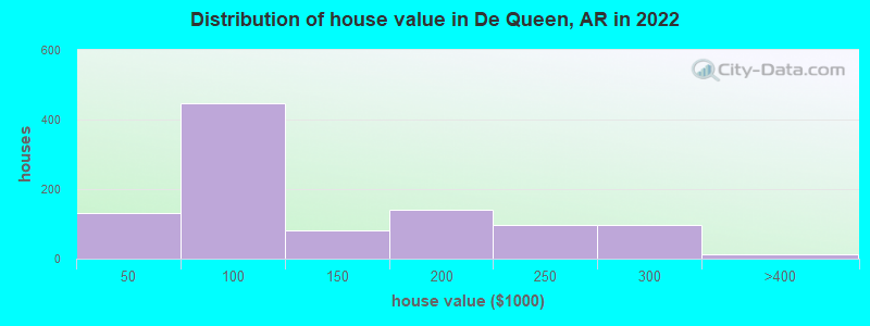
Estimated median house or condo value in 2022: $103,296 (it was $51,000 in 2000)
| De Queen: | $103,296 |
| AR: | $179,800 |
Mean prices in 2022: all housing units: $124,988; detached houses: $139,125; mobile homes: $14,123
Median gross rent in 2022: $659.
(11.9% for White Non-Hispanic residents, 1.7% for Black residents, 19.4% for Hispanic or Latino residents, 16.7% for American Indian residents, 100.0% for Native Hawaiian and other Pacific Islander residents, 17.1% for other race residents, 37.5% for two or more races residents)
Detailed information about poverty and poor residents in De Queen, AR
Compare current foreclosures near De Queen, AR:
| Photo | Address | Area | Beds / Baths | Price | Details |
|---|---|---|---|---|---|

|
#1
Peterson Ln
De Queen, AR 71832
|
2,186 sq. feet
|
2 baths 3 beds |
show details | |

|
#2
Northgate Dr
De Queen, AR 71832
|
2,784 sq. feet
|
3 baths 4 beds |
show details | |

|
#3
W Robinson Rd
De Queen, AR 71832
|
1,305 sq. feet
|
1 baths - beds |
show details | |

|
#4
Westwood Dr
De Queen, AR 71832
|
2,224 sq. feet
|
2 baths - beds |
show details | |

|
#5
Broken Pine St
De Queen, AR 71832
|
1,211 sq. feet
|
1 baths - beds |
show details | |

|
#6
W Coulter Ave
De Queen, AR 71832
|
968 sq. feet
|
1 baths - beds |
show details | |

|
#7
Wommack Ln
De Queen, AR 71832
|
- sq. feet
|
- baths - beds |
show details | |

|
#8
Westwood Dr
De Queen, AR 71832
|
- sq. feet
|
- baths - beds |
show details | |

|
#9
Geneva Church Rd
De Queen, AR 71832
|
- sq. feet
|
- baths - beds |
show details | |

|
#10
Broken Pine St
De Queen, AR 71832
|
- sq. feet
|
- baths - beds |
show details |
| Photo | Address | Area | Beds / Baths | Price | Details |
|---|---|---|---|---|---|

|
#11
Process Hts
De Queen, AR 71832
|
- sq. feet
|
- baths - beds |
show details | |

|
#12
Long Meadow Dr
De Queen, AR 71832
|
- sq. feet
|
- baths - beds |
show details | |

|
#13
Barnhart Rd
Horatio, AR 71842
|
1,032 sq. feet
|
1 baths - beds |
show details | |

|
#14
Stancil Ln
Gillham, AR 71841
|
1,680 sq. feet
|
1 baths - beds |
show details | |

|
#15
Froglevel Rd
Horatio, AR 71842
|
672 sq. feet
|
1 baths - beds |
show details | |

|
#16
Melrose Rd
Lockesburg, AR 71846
|
1,721 sq. feet
|
2 baths - beds |
show details | |

|
#17
Frachiseur Rd
Grannis, AR 71944
|
1,812 sq. feet
|
1 baths - beds |
show details | |

|
#18
Peridot Rd
Haworth, OK 74740
|
- sq. feet
|
- baths - beds |
show details | |

|
#19
Old Dierks Hwy
Lockesburg, AR 71846
|
- sq. feet
|
- baths - beds |
show details | |

|
#20
Wise Ln
Grannis, AR 71944
|
- sq. feet
|
- baths - beds |
show details |
| Photo | Address | Area | Beds / Baths | Price | Details |
|---|---|---|---|---|---|

|
#21
Little River 65
Foreman, AR 71836
|
- sq. feet
|
- baths - beds |
show details | |

|
Check over 1 million property listings on Foreclosure.com!
|
browse all offers | |||


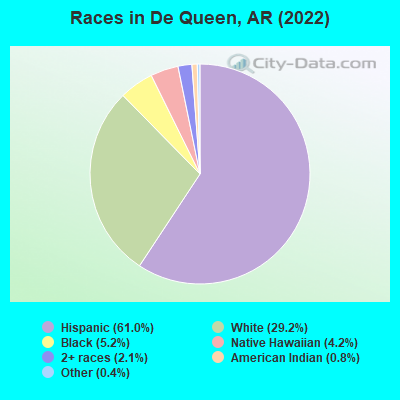
- 3,77461.0%Hispanic
- 1,80629.2%White alone
- 3195.2%Black alone
- 2624.2%Native Hawaiian and Other
Pacific Islander alone - 1292.1%Two or more races
- 510.8%American Indian alone
- 250.4%Other race alone
According to our research of Arkansas and other state lists, there were 5 registered sex offenders living in De Queen, Arkansas as of April 28, 2024.
The ratio of all residents to sex offenders in De Queen is 1,340 to 1.
The ratio of registered sex offenders to all residents in this city is much lower than the state average.
Type |
2009 |
2010 |
2011 |
2012 |
2013 |
2014 |
2015 |
2016 |
2017 |
2018 |
2019 |
2020 |
2021 |
2022 |
|---|---|---|---|---|---|---|---|---|---|---|---|---|---|---|
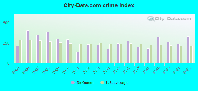
| Murders (per 100,000) | 0 (0.0) | 0 (0.0) | 0 (0.0) | 0 (0.0) | 0 (0.0) | 0 (0.0) | 0 (0.0) | 2 (29.7) | 0 (0.0) | 0 (0.0) | 0 (0.0) | 0 (0.0) | 2 (31.3) | 3 (49.4) |
| Rapes (per 100,000) | 1 (16.8) | 6 (91.0) | 0 (0.0) | 3 (44.7) | 4 (60.3) | 2 (29.6) | 5 (73.7) | 2 (29.7) | 4 (61.0) | 1 (15.2) | 10 (151.7) | 4 (61.3) | 2 (31.3) | 4 (65.9) |
| Robberies (per 100,000) | 0 (0.0) | 4 (60.7) | 4 (60.2) | 1 (14.9) | 1 (15.1) | 1 (14.8) | 2 (29.5) | 1 (14.9) | 1 (15.3) | 1 (15.2) | 0 (0.0) | 3 (46.0) | 0 (0.0) | 0 (0.0) |
| Assaults (per 100,000) | 17 (284.8) | 19 (288.1) | 8 (120.4) | 16 (238.5) | 6 (90.4) | 12 (177.8) | 10 (147.5) | 19 (282.6) | 12 (183.1) | 17 (258.0) | 23 (348.9) | 19 (291.1) | 11 (172.2) | 22 (362.5) |
| Burglaries (per 100,000) | 96 (1,608) | 63 (955.4) | 59 (888.0) | 56 (834.8) | 58 (874.0) | 44 (652.0) | 51 (752.1) | 51 (758.5) | 40 (610.2) | 44 (667.9) | 64 (970.7) | 60 (919.4) | 49 (767.2) | 29 (477.8) |
| Thefts (per 100,000) | 160 (2,680) | 105 (1,592) | 60 (903.1) | 142 (2,117) | 133 (2,004) | 101 (1,497) | 145 (2,138) | 124 (1,844) | 96 (1,465) | 107 (1,624) | 106 (1,608) | 111 (1,701) | 80 (1,253) | 100 (1,648) |
| Auto thefts (per 100,000) | 9 (150.8) | 11 (166.8) | 4 (60.2) | 1 (14.9) | 13 (195.9) | 7 (103.7) | 7 (103.2) | 4 (59.5) | 10 (152.6) | 4 (60.7) | 4 (60.7) | 11 (168.6) | 8 (125.3) | 7 (115.3) |
| Arson (per 100,000) | 0 (0.0) | 1 (15.2) | 1 (15.1) | 1 (14.9) | 1 (15.1) | 4 (59.3) | 0 (0.0) | 2 (29.7) | 1 (15.3) | 2 (30.4) | 0 (0.0) | 0 (0.0) | 3 (47.0) | 2 (33.0) |
| City-Data.com crime index | 302.2 | 292.5 | 145.2 | 232.3 | 227.8 | 177.5 | 243.8 | 275.9 | 203.5 | 184.9 | 328.2 | 266.9 | 235.9 | 332.7 |
The City-Data.com crime index weighs serious crimes and violent crimes more heavily. Higher means more crime, U.S. average is 246.1. It adjusts for the number of visitors and daily workers commuting into cities.
Crime rate in De Queen detailed stats: murders, rapes, robberies, assaults, burglaries, thefts, arson
Full-time law enforcement employees in 2021, including police officers: 16 (16 officers - 15 male; 1 female).
| Officers per 1,000 residents here: | 2.51 |
| Arkansas average: | 2.25 |
 Recent articles from our blog. Our writers, many of them Ph.D. graduates or candidates, create easy-to-read articles on a wide variety of topics.

 | Why so many Hispanics in Rogers and Springdale? (87 replies) |
| Best driving route from NWA to Texarkana (7 replies) |
| Looking for information about Camden,Ar (22 replies) |
| Best place to live in Arkansas? (476 replies) |
| What's your favorite town name in Arkansas? (121 replies) |
| Moving to SW AR from NE--Need advice (10 replies) |
Latest news from De Queen, AR collected exclusively by city-data.com from local newspapers, TV, and radio stations
Ancestries: Irish (6.6%), American (2.3%), English (1.8%).
Current Local Time: CST time zone
Incorporated on 01/09/1897
Elevation: 422 feet
Land area: 5.63 square miles.
Population density: 1,074 people per square mile (low).
1,717 residents are foreign born (25.0% Latin America).
| This city: | 27.8% |
| Arkansas: | 5.0% |
| De Queen city: | 0.6% ($315) |
| Arkansas: | 0.7% ($500) |
Nearest city with pop. 50,000+: Fort Smith, AR  (92.0 miles , pop. 80,268).
Nearest city with pop. 200,000+: Shreveport, LA (113.6 miles , pop. 200,145).
Nearest city with pop. 1,000,000+: Dallas, TX (165.2 miles , pop. 1,188,580).
Nearest cities:
), ), ), ), Latitude: 34.04 N, Longitude: 94.34 W
Daytime population change due to commuting: +1,254 (+20.3%)
Workers who live and work in this city: 1,875 (67.9%)
Area code: 870
De Queen, Arkansas accommodation & food services, waste management - Economy and Business Data
Single-family new house construction building permits:
- 2022: 7 buildings, average cost: $33,300
- 2021: 6 buildings, average cost: $33,300
- 2020: 5 buildings, average cost: $33,300
- 2019: 5 buildings, average cost: $33,300
- 2018: 5 buildings, average cost: $33,300
- 2017: 4 buildings, average cost: $33,300
- 2016: 4 buildings, average cost: $33,300
- 2015: 3 buildings, average cost: $33,300
- 2014: 8 buildings, average cost: $37,800
- 2013: 9 buildings, average cost: $37,800
- 2012: 10 buildings, average cost: $90,000
- 2011: 3 buildings, average cost: $23,300
- 2010: 2 buildings, average cost: $40,000
- 2009: 4 buildings, average cost: $20,000
- 2008: 4 buildings, average cost: $16,700
- 2007: 6 buildings, average cost: $16,700
- 2006: 11 buildings, average cost: $65,000
- 2005: 10 buildings, average cost: $75,000
- 2004: 7 buildings, average cost: $66,600
- 2003: 6 buildings, average cost: $66,600
- 2002: 5 buildings, average cost: $66,600
- 2001: 8 buildings, average cost: $75,800
- 2000: 7 buildings, average cost: $75,800
- 1999: 6 buildings, average cost: $39,000
- 1998: 4 buildings, average cost: $80,000
- 1997: 10 buildings, average cost: $53,900
| Here: | 4.0% |
| Arkansas: | 3.4% |
Population change in the 1990s: +1,094 (+23.4%).
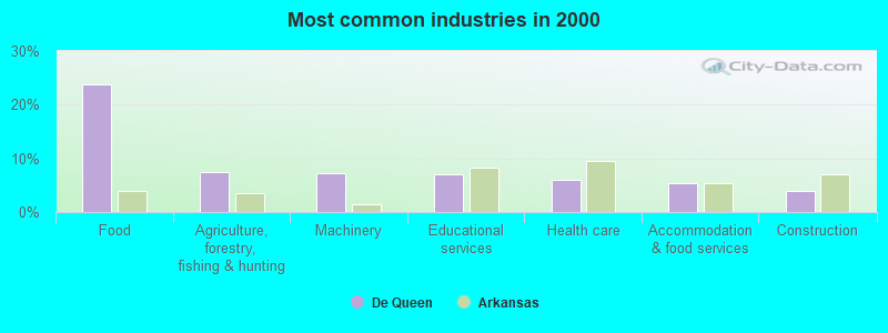
- Food (23.8%)
- Agriculture, forestry, fishing & hunting (7.4%)
- Machinery (7.3%)
- Educational services (7.1%)
- Health care (6.0%)
- Accommodation & food services (5.5%)
- Construction (4.0%)
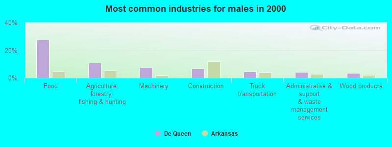
- Food (27.5%)
- Agriculture, forestry, fishing & hunting (11.1%)
- Machinery (7.7%)
- Construction (6.6%)
- Truck transportation (4.5%)
- Administrative & support & waste management services (4.3%)
- Wood products (3.5%)
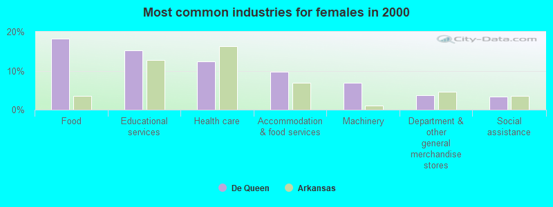
- Food (18.2%)
- Educational services (15.3%)
- Health care (12.4%)
- Accommodation & food services (9.7%)
- Machinery (6.8%)
- Department & other general merchandise stores (3.8%)
- Social assistance (3.4%)
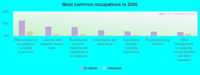
- Other production occupations, including supervisors (12.7%)
- Laborers and material movers, hand (7.8%)
- Building and grounds cleaning and maintenance occupations (7.5%)
- Assemblers and fabricators (4.8%)
- Agricultural workers, including supervisors (3.9%)
- Food processing workers (3.7%)
- Other management occupations, except farmers and farm managers (3.3%)
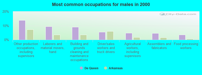
- Other production occupations, including supervisors (13.9%)
- Laborers and material movers, hand (9.4%)
- Building and grounds cleaning and maintenance occupations (9.1%)
- Driver/sales workers and truck drivers (5.5%)
- Agricultural workers, including supervisors (4.7%)
- Assemblers and fabricators (4.6%)
- Food processing workers (3.6%)
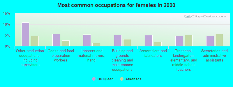
- Other production occupations, including supervisors (10.9%)
- Cooks and food preparation workers (5.7%)
- Laborers and material movers, hand (5.4%)
- Building and grounds cleaning and maintenance occupations (5.1%)
- Assemblers and fabricators (5.0%)
- Preschool, kindergarten, elementary, and middle school teachers (4.8%)
- Secretaries and administrative assistants (4.8%)
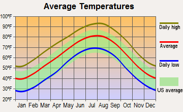
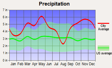
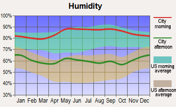
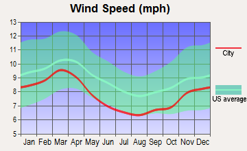
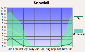
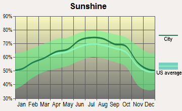
Average climate in De Queen, Arkansas
Based on data reported by over 4,000 weather stations
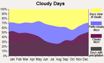
|
|


Tornado activity:
De Queen-area historical tornado activity is slightly below Arkansas state average. It is 59% greater than the overall U.S. average.
On 4/2/1982, a category F5 (max. wind speeds 261-318 mph) tornado 13.4 miles away from the De Queen city center injured 29 people and caused between $500,000 and $5,000,000 in damages.
On 4/2/1982, a category F4 (max. wind speeds 207-260 mph) tornado 8.4 miles away from the city center killed 3 people and injured 23 people and caused between $500,000 and $5,000,000 in damages.
Earthquake activity:
De Queen-area historical earthquake activity is significantly above Arkansas state average. It is 522% greater than the overall U.S. average.On 11/6/2011 at 03:53:10, a magnitude 5.7 (5.7 MW, Depth: 3.2 mi, Class: Moderate, Intensity: VI - VII) earthquake occurred 172.0 miles away from De Queen center
On 9/3/2016 at 12:02:44, a magnitude 5.8 (5.8 MW, Depth: 3.5 mi) earthquake occurred 220.4 miles away from De Queen center
On 5/17/2012 at 08:12:00, a magnitude 4.8 (4.8 MW, Depth: 3.1 mi, Class: Light, Intensity: IV - V) earthquake occurred 146.2 miles away from De Queen center
On 11/7/2016 at 01:44:24, a magnitude 5.0 (5.0 MW, Depth: 2.8 mi) earthquake occurred 194.0 miles away from the city center
On 2/28/2011 at 05:00:50, a magnitude 4.7 (4.7 MW, Depth: 2.0 mi) earthquake occurred 141.4 miles away from the city center
On 1/21/1982 at 00:33:54, a magnitude 4.7 (4.5 MB, 4.7 LG, 4.5 LG) earthquake occurred 144.5 miles away from De Queen center
Magnitude types: regional Lg-wave magnitude (LG), body-wave magnitude (MB), moment magnitude (MW)
Natural disasters:
The number of natural disasters in Sevier County (12) is smaller than the US average (15).Major Disasters (Presidential) Declared: 9
Emergencies Declared: 2
Causes of natural disasters: Storms: 8, Floods: 7, Tornadoes: 5, Winds: 2, Winter Storms: 2, Hurricane: 1, Other: 1 (Note: some incidents may be assigned to more than one category).
Hospitals and medical centers in De Queen:
- DE QUEEN MEDICAL CENTER, INC (Voluntary non-profit - Other, provides emergency services, 1306 WEST COLLIN RAYE DRIVE)
- DEQUEEN HOME HEALTH, AN AMEDISYS COMPANY (304 WEST COLLIN RAYE DRIVE, SUITE 106 A)
- SEVIER COUNTY HEALTH UNIT (304 NORTH FOURTH STREET)
- 1SEVIER HEALTHCARE (1206 COLLIN RAYE DRIVE)
- BROOKEWOOD NURSING AND REHAB (322 WEST COLLIN RAYE DRIVE)
- BROOKWOOD NURSING CENTER (HWY 70 W BOX 71)
Airports and heliports located in De Queen:
- J Lynn Helms Sevier County Airport (DEQ) (Runways: 1, Itinerant Ops: 1,500, Local Ops: 6,000, Military Ops: 200)
- Community Hospital Of De Queen Heliport (01AR)
College/University in De Queen:
Colleges/universities with over 2000 students nearest to De Queen:
- Texarkana College (about 45 miles; Texarkana, TX; Full-time enrollment: 2,629)
- Carl Albert State College (about 72 miles; Poteau, OK; FT enrollment: 2,041)
- Northeast Texas Community College (about 72 miles; Mount Pleasant, TX; FT enrollment: 2,320)
- Paris Junior College (about 74 miles; Paris, TX; FT enrollment: 3,875)
- Henderson State University (about 74 miles; Arkadelphia, AR; FT enrollment: 3,528)
- National Park Community College (about 78 miles; Hot Springs, AR; FT enrollment: 2,237)
- Southern Arkansas University Main Campus (about 83 miles; Magnolia, AR; FT enrollment: 3,005)
Public high schools in De Queen:
- DEQUEEN HIGH SCHOOL (Location: 1803 W COULTER DR, Grades: 10-12)
- DEQUEEN JUNIOR HIGH SCHOOL (Location: 1803 W COLTER DR, Grades: 8-9)
Public elementary/middle schools in De Queen:
- DEQUEEN ELEMENTARY SCHOOL (Location: 233 TREATING PLANT RD, Grades: 3-5)
- DEQUEEN MIDDLE SCHOOL (Location: 1803 W COULTER DR, Grades: 6-7)
- DEQUEEN PRIMARY (Location: 235 TREATING PLANT RD, Grades: KG-2)
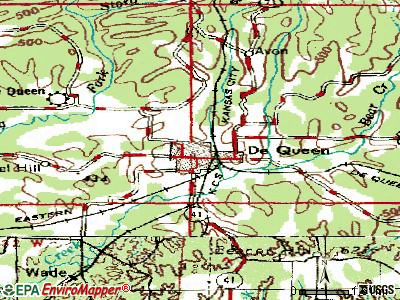
Points of interest:
Notable locations in De Queen: Bear Creek Junction (A), Sevier County Courthouse (B), Ridgeview Lodge Nursing Home (C), De Queen Manor Nursing Home (D), De Queen Police Department (E), South Central Arkansas Drug Task Force (F), Sevier County Sheriff Office (G), De Queen Fire Station (H), Southwest Emergency Medical Service - DeQueen (I), Lifenet, Incorporated - De Queen (Ambulance Services) (J). Display/hide their locations on the map
Shopping Center: Town North Shopping Center (1). Display/hide its location on the map
Cemeteries: Herman Direk Memorial Park (1), Redman Cemetery (2). Display/hide their locations on the map
Tourist attraction: Sevier County Historical Society Museum (717 North Maple Avenue).
Hotels: De Queen Country Club & Lodging (133 Club House Drive), Western Plaza Inn (110 Highway 71 North), Aztec TANZ (110 Highway 71 North), Dequeen Courtyard Inn (111 Highway 71 North), Scottish Inns (150 Highway 71 North), Palace Motel (607 West Collin Raye Drive).
Courts: Sevier County - de Queen- Municipal Court Probation Officer (Courthouse), Sevier County - de Queen- Municipal Court Clerk (Courthouse).
Birthplace of: Collin Raye - Country singer, Wes Watkins - Politician.
| This city: | 3.2 people |
| Arkansas: | 2.5 people |
| This city: | 72.6% |
| Whole state: | 67.6% |
| This city: | 6.6% |
| Whole state: | 5.7% |
Likely homosexual households (counted as self-reported same-sex unmarried-partner households)
- Lesbian couples: 0.2% of all households
- Gay men: 0.2% of all households
People in group quarters in De Queen in 2010:
- 144 people in nursing facilities/skilled-nursing facilities
- 25 people in local jails and other municipal confinement facilities
- 4 people in correctional residential facilities
People in group quarters in De Queen in 2000:
- 133 people in nursing homes
- 21 people in homes for the physically handicapped
- 8 people in homes for the mentally retarded
- 7 people in local jails and other confinement facilities (including police lockups)
Banks with branches in De Queen (2011 data):
- First National Bank: Highway 70 Branch at 504 Collin Raye Drive, branch established on 1980/01/29; Dequeen Main Branch at 121 South Third Street, branch established on 2007/08/17. Info updated 2012/01/13: Bank assets: $718.1 mil, Deposits: $547.7 mil, headquarters in Hot Springs, AR, positive income, Commercial Lending Specialization, 31 total offices, Holding Company: First National Security Company
- First State Bank of DeQueen: First State Bank Of Dequeen at 402 West Collin Raye Drive, branch established on 1974/11/01; North Side Branch at 310 N Third St, branch established on 1979/05/02. Info updated 2006/11/03: Bank assets: $179.7 mil, Deposits: $154.8 mil, local headquarters, positive income, Agricultural Specialization, 6 total offices, Holding Company: First State Bancshares, Inc.
- BancorpSouth Bank: Dequeen Branch at 1011 West Collin Raye Drive, branch established on 1889/01/01. Info updated 2007/07/18: Bank assets: $12,990.3 mil, Deposits: $10,863.8 mil, headquarters in Tupelo, MS, positive income, Commercial Lending Specialization, 271 total offices, Holding Company: Bancorpsouth, Inc.
For population 15 years and over in De Queen:

- Never married: 33.9%
- Now married: 45.9%
- Separated: 0.2%
- Widowed: 6.2%
- Divorced: 13.8%
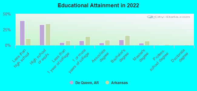
For population 25 years and over in De Queen:
- High school or higher: 57.6%
- Bachelor's degree or higher: 12.0%
- Graduate or professional degree: 3.8%
- Unemployed: 5.5%
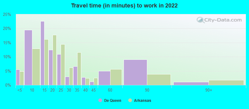
- Mean travel time to work (commute): 21.2 minutes
| Here: | 20.8 |
| Arkansas average: | 11.4 |
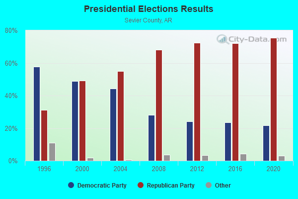
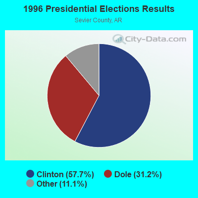
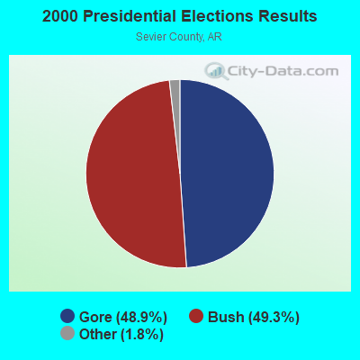
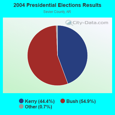
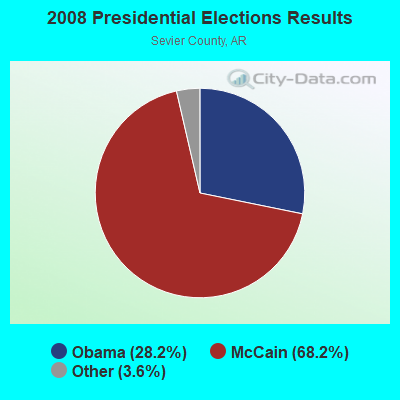
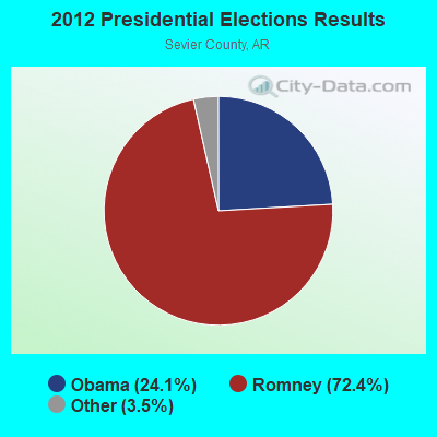

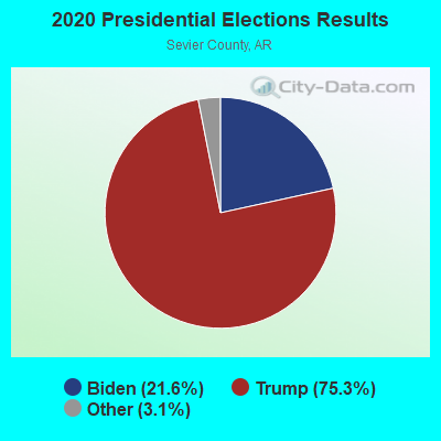
Graphs represent county-level data. Detailed 2008 Election Results
Religion statistics for De Queen, AR (based on Sevier County data)
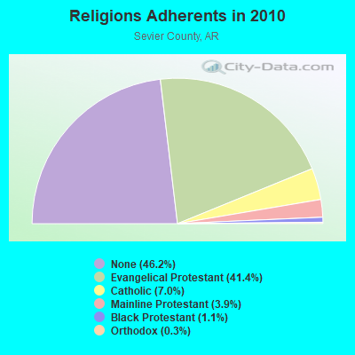
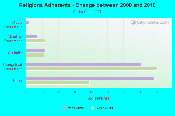
| Religion | Adherents | Congregations |
|---|---|---|
| Evangelical Protestant | 7,062 | 37 |
| Catholic | 1,200 | 1 |
| Mainline Protestant | 664 | 9 |
| Black Protestant | 196 | 1 |
| Orthodox | 51 | 1 |
| Other | 1 | 1 |
| None | 7,884 | - |
Food Environment Statistics:
| This county: | 2.46 / 10,000 pop. |
| State: | 2.02 / 10,000 pop. |
| Here: | 0.62 / 10,000 pop. |
| State: | 0.59 / 10,000 pop. |
| Sevier County: | 7.38 / 10,000 pop. |
| Arkansas: | 4.94 / 10,000 pop. |
| This county: | 3.08 / 10,000 pop. |
| State: | 6.66 / 10,000 pop. |
| This county: | 10.3% |
| State: | 9.8% |
| Sevier County: | 30.5% |
| State: | 29.1% |
| Sevier County: | 17.1% |
| Arkansas: | 13.6% |
Health and Nutrition:
| Here: | 44.9% |
| Arkansas: | 48.2% |
| De Queen: | 42.8% |
| State: | 44.2% |
| De Queen: | 28.5 |
| Arkansas: | 28.9 |
| This city: | 22.8% |
| State: | 21.6% |
| Here: | 10.8% |
| Arkansas: | 11.3% |
| Here: | 6.8 |
| Arkansas: | 6.8 |
| De Queen: | 30.4% |
| Arkansas: | 34.0% |
| This city: | 53.1% |
| Arkansas: | 54.4% |
| De Queen: | 78.6% |
| Arkansas: | 78.0% |
More about Health and Nutrition of De Queen, AR Residents
| Local government employment and payroll (March 2022) | |||||
| Function | Full-time employees | Monthly full-time payroll | Average yearly full-time wage | Part-time employees | Monthly part-time payroll |
|---|---|---|---|---|---|
| Police Protection - Officers | 18 | $72,061 | $48,041 | 0 | $0 |
| Water Supply | 10 | $35,477 | $42,572 | 0 | $0 |
| Sewerage | 7 | $24,226 | $41,530 | 0 | $0 |
| Financial Administration | 7 | $28,518 | $48,888 | 0 | $0 |
| Streets and Highways | 6 | $20,381 | $40,762 | 0 | $0 |
| Parks and Recreation | 5 | $16,745 | $40,188 | 0 | $0 |
| Firefighters | 5 | $19,608 | $47,059 | 0 | $0 |
| Solid Waste Management | 4 | $11,879 | $35,637 | 0 | $0 |
| Judicial and Legal | 4 | $15,186 | $45,558 | 0 | $0 |
| Other and Unallocable | 1 | $2,303 | $27,636 | 0 | $0 |
| Totals for Government | 67 | $246,386 | $44,129 | 0 | $0 |
De Queen government finances - Expenditure in 2021 (per resident):
- Current Operations - Police Protection: $1,209,000 ($200.10)
Water Utilities: $868,000 ($143.66)
Sewerage: $758,000 ($125.46)
Financial Administration: $661,000 ($109.40)
Regular Highways: $492,000 ($81.43)
Local Fire Protection: $417,000 ($69.02)
Parks and Recreation: $395,000 ($65.38)
Solid Waste Management: $253,000 ($41.87)
Judicial and Legal Services: $247,000 ($40.88)
- General - Interest on Debt: $102,000 ($16.88)
- Intergovernmental to Local - Other - General - Other: $59,000 ($9.76)
De Queen government finances - Revenue in 2021 (per resident):
- Charges - Sewerage: $1,535,000 ($254.05)
Solid Waste Management: $400,000 ($66.20)
Parks and Recreation: $36,000 ($5.96)
- Miscellaneous - Fines and Forfeits: $168,000 ($27.81)
Interest Earnings: $105,000 ($17.38)
Rents: $53,000 ($8.77)
- Revenue - Water Utilities: $1,554,000 ($257.20)
- State Intergovernmental - Highways: $529,000 ($87.55)
General Local Government Support: $167,000 ($27.64)
- Tax - General Sales and Gross Receipts: $1,586,000 ($262.50)
Property: $301,000 ($49.82)
Public Utilities Sales: $220,000 ($36.41)
De Queen government finances - Debt in 2021 (per resident):
- Long Term Debt - Beginning Outstanding - Unspecified Public Purpose: $2,539,000 ($420.23)
Outstanding Unspecified Public Purpose: $1,839,000 ($304.37)
Retired Unspecified Public Purpose: $700,000 ($115.86)
De Queen government finances - Cash and Securities in 2021 (per resident):
- Other Funds - Cash and Securities: $7,381,000 ($1221.62)
| Businesses in De Queen, AR | ||||
| Name | Count | Name | Count | |
|---|---|---|---|---|
| Baskin-Robbins | 1 | Nike | 1 | |
| Chevrolet | 1 | Pizza Hut | 1 | |
| FedEx | 1 | RadioShack | 1 | |
| Ford | 1 | SONIC Drive-In | 1 | |
| H&R Block | 1 | Subway | 1 | |
| KFC | 1 | U-Haul | 1 | |
| La-Z-Boy | 1 | Walmart | 1 | |
| McDonald's | 1 | |||
Strongest AM radio stations in De Queen:
- KEEL (710 AM; 50 kW; SHREVEPORT, LA; Owner: CITICASTERS LICENSES, L.P.)
- KWKH (1130 AM; 50 kW; SHREVEPORT, LA; Owner: CITICASTERS LICENSES, L.P.)
- KGHT (880 AM; 50 kW; SHERIDAN, AR; Owner: METROPOLITAN RADIO GROUP, INC.)
- KWXI (670 AM; daytime; 5 kW; GLENWOOD, AR; Owner: PGR COMMUNICATIONS, INC.)
- KAAY (1090 AM; 50 kW; LITTLE ROCK, AR; Owner: CITADEL BROADCASTING COMPANY)
- KPYN (900 AM; 10 kW; ATLANTA, TX; Owner: FAMILY WORSHIP CENTER CHURCH, INC.)
- KFXR (1190 AM; 50 kW; DALLAS, TX; Owner: CLEAR CHANNEL BROADCASTING LICENSES, INC.)
- KRMG (740 AM; 50 kW; TULSA, OK; Owner: CXR HOLDINGS, INC.)
- KRLD (1080 AM; 50 kW; DALLAS, TX; Owner: TEXAS INFINITY BROADCASTING L.P.)
- WBAP (820 AM; 50 kW; FORT WORTH, TX; Owner: WBAP-KSCS OPERATING, LTD.)
- KFAQ (1170 AM; 50 kW; TULSA, OK; Owner: JOURNAL BROADCAST CORPORATION)
- KTFS (940 AM; 2 kW; TEXARKANA, TX; Owner: ARKLATEX, LLC)
- KESS (1270 AM; 50 kW; FORT WORTH, TX; Owner: KESS-AM LICENSE CORP.)
Strongest FM radio stations in De Queen:
- KBPU (88.7 FM; DE QUEEN, AR; Owner: AMERICAN FAMILY ASSOCIATION)
- KDQN-FM (92.1 FM; DE QUEEN, AR; Owner: JAY W. BUNYARD & ANNE W. BUNYARD)
- KKBI (106.1 FM; BROKEN BOW, OK; Owner: J.D.C. RADIO, INC.)
- KTTG (96.3 FM; MENA, AR; Owner: PEARSON BROADCASTING OF MENA, INC.)
TV broadcast stations around De Queen:
- K08KF (Channel 8; De QUEEN, AR; Owner: FIRST ASSEMBLY OF GOD)
- K28DJ (Channel 28; BROKEN BOW, OK; Owner: TRUSTEES OF J.B.CALLAHAM R.T.)
- K63BA (Channel 63; IDABEL, OK; Owner: OKLAHOMA EDUCATIONAL TELEVISION AUTHORITY)
- National Bridge Inventory (NBI) Statistics
- 33Number of bridges
- 433ft / 132mTotal length
- $114,490,000Total costs
- 75,771Total average daily traffic
- 8,021Total average daily truck traffic
- 82,697Total future (year 2007) average daily traffic

- New bridges - historical statistics
- 11920-1929
- 21930-1939
- 81940-1949
- 41960-1969
- 91970-1979
- 11980-1989
- 11990-1999
- 32000-2009
- 22010-2019
- 22020-2022
FCC Registered Antenna Towers:
20 (See the full list of FCC Registered Antenna Towers in De Queen)FCC Registered Broadcast Land Mobile Towers:
7- Lat: 33.994444 Lon: -94.285444, Call Sign: WPJK930,
Assigned Frequencies: 39.1800 MHz, 37.1000 MHz, Grant Date: 01/12/2013, Expiration Date: 03/30/2023, Cancellation Date: 06/03/2023, Certifier: Dick Tallman, Registrant: Lindsey Communications, Inc, 213 Main Street, Horatio, AR 71842, Phone: (870) 832-3891, Fax: (870) 832-6102, Email:
- 301 Stillwell (Lat: 34.036222 Lon: -94.340472), Call Sign: WZP376,
Assigned Frequencies: 153.455 MHz, 153.545 MHz, 153.620 MHz, 158.220 MHz, 158.235 MHz, Grant Date: 04/01/2005, Expiration Date: 04/11/2015, Cancellation Date: 06/13/2015, Registrant: Universal Licensing Service, 3419 Via Lido Suite 609, Newport Beach, CA 92663-3908, Phone: (877) 677-3639, Fax: (949) 723-2025
- Hwy 70 71 Approx 1200 Ft W Of Int W Cr 102 (Lat: 34.045944 Lon: -94.277694), Type: Tower, Structure height: 5 m, Overall height: 7 m, Call Sign: WPMW881,
Assigned Frequencies: 452.275 MHz, Grant Date: 02/06/2024, Expiration Date: 03/03/2034, Certifier: Don Stemple, Registrant: Sevier County Water Assoc., 479 Dequeen Lake Rd, Dequeen, AR 71832, Phone: (870) 642-5289, Fax: (870) 642-6484, Email:
- 812 E Townsend (Lat: 34.050389 Lon: -94.329639), Call Sign: KCL728,
Assigned Frequencies: 153.710 MHz, Grant Date: 05/17/2005, Expiration Date: 07/19/2015, Cancellation Date: 09/19/2015, Registrant: Business Radio Licensing, 26941 Cabot Rd 134, Laguna Hills, CA 92653, Phone: (949) 348-8510, Email:
- De Queen Station 124 N Port N Arthur St & De Queen Ave (Lat: 34.039278 Lon: -94.336028), Call Sign: KCK356, Licensee ID: L00003692,
Assigned Frequencies: 160.260 MHz, 160.305 MHz, 160.350 MHz, 160.740 MHz, 161.250 MHz, Grant Date: 03/23/1999, Expiration Date: 05/10/2004, Cancellation Date: 07/21/2003, Registrant: Kansas City Southern Railway Co, 4601 Shreveport Blanchard Hwy, Shreveport, LA 71107-5797, Phone: (318) 227-7262
- RADIO SHOP, Dq & E Rr Depot (Lat: 34.036028 Lon: -94.334861), Type: Bant, Structure height: 12 m, Overall height: 18 m, Call Sign: KKF848,
Assigned Frequencies: 160.230 MHz, 160.785 MHz, 161.445 MHz, 161.505 MHz, Grant Date: 07/13/2022, Expiration Date: 07/17/2032, Certifier: Tom Williams, Registrant: Dequeen &eastern Railroad LLC, 412 E Lockesburg Street, Dequeen, AR 71832, Phone: (870) 642-1355, Fax: (870) 642-1368, Email:
- 606 E Collin Raye Drive (Lat: 34.045000 Lon: -94.324167), Call Sign: WPWY735,
Assigned Frequencies: 469.212 MHz, 469.037 MHz, 469.237 MHz, 469.062 MHz, 469.262 MHz, 469.087 MHz, 469.287 MHz, 469.112 MHz, 469.312 MHz, 469.137 MHz... (+21 more), Grant Date: 02/11/2003, Expiration Date: 02/11/2013, Cancellation Date: 04/13/2013, Certifier: Diane Baribeau, Registrant: Panasonic Information Systems Company, 1707 N Randall Road E1-D9, Elgin, IL 60123-7847, Phone: (847) 468-5318, Fax: (847) 468-5331, Email:
FCC Registered Microwave Towers:
5 (See the full list of FCC Registered Microwave Towers in this town)FCC Registered Paging Towers:
2 (See the full list of FCC Registered Paging Towers)FCC Registered Maritime Coast & Aviation Ground Towers:
1 (See the full list of FCC Registered Maritime Coast & Aviation Ground Towers)FCC Registered Amateur Radio Licenses:
28 (See the full list of FCC Registered Amateur Radio Licenses in De Queen)FAA Registered Aircraft:
8 (See the full list of FAA Registered Aircraft in De Queen)2006 - 2018 National Fire Incident Reporting System (NFIRS) incidents
- Fire incident types reported to NFIRS in De Queen, AR
- 11752.5%Outside Fires
- 6529.1%Structure Fires
- 3616.1%Mobile Property/Vehicle Fires
- 52.2%Other
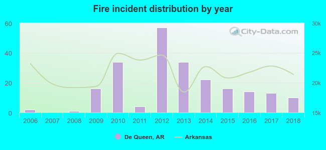 According to the data from the years 2006 - 2018 the average number of fire incidents per year is 17. The highest number of reported fire incidents - 57 took place in 2012, and the least - 0 in 2007. The data has a rising trend.
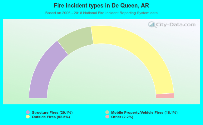 When looking into fire subcategories, the most incidents belonged to: Outside Fires (52.5%), and Structure Fires (29.1%).
| Most common first names in De Queen, AR among deceased individuals | ||
| Name | Count | Lived (average) |
|---|---|---|
| James | 80 | 72.6 years |
| John | 71 | 78.8 years |
| Mary | 66 | 80.1 years |
| William | 62 | 78.9 years |
| Charles | 47 | 72.5 years |
| Robert | 37 | 72.4 years |
| Roy | 27 | 71.5 years |
| George | 24 | 75.3 years |
| Thomas | 23 | 79.6 years |
| Ruth | 22 | 80.3 years |
| Most common last names in De Queen, AR among deceased individuals | ||
| Last name | Count | Lived (average) |
|---|---|---|
| Smith | 66 | 76.3 years |
| Jones | 36 | 76.0 years |
| Miller | 26 | 74.5 years |
| Johnson | 24 | 74.8 years |
| Wilson | 23 | 72.9 years |
| Cox | 23 | 78.9 years |
| Taylor | 22 | 73.8 years |
| Brown | 22 | 81.3 years |
| Williams | 21 | 76.0 years |
| Davis | 21 | 80.1 years |
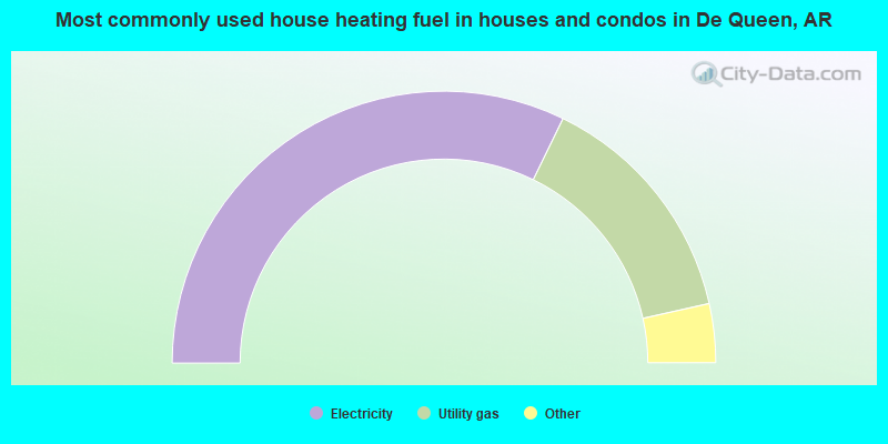
- 64.5%Electricity
- 28.6%Utility gas
- 3.3%Bottled, tank, or LP gas
- 2.8%Wood
- 0.8%No fuel used

- 65.5%Electricity
- 34.5%Utility gas
De Queen compared to Arkansas state average:
- Median house value below state average.
- Unemployed percentage below state average.
- Black race population percentage below state average.
- Hispanic race population percentage significantly above state average.
- Median age significantly below state average.
- Foreign-born population percentage significantly above state average.
De Queen on our top lists:
- #6 on the list of "Top 101 cities with largest percentage of females in industries: manufacturing (population 5,000+)"
- #7 on the list of "Top 101 cities with largest percentage of males in occupations: material moving occupations (population 5,000+)"
- #23 on the list of "Top 101 cities with largest percentage of females in occupations: material moving occupations (population 5,000+)"
- #29 on the list of "Top 101 cities with largest percentage of males in industries: manufacturing (population 5,000+)"
- #43 on the list of "Top 101 cities with largest percentage of males in occupations: production occupations (population 5,000+)"
- #51 on the list of "Top 101 cities with the most people carpooling to work (population 5,000+)"
- #52 on the list of "Top 101 cities with the largest percentage of people in homes for the physically handicapped (population 1,000+)"
- #58 on the list of "Top 101 cities with the largest city-data.com crime index increase from 2011 to 2012 (population 5,000+)"
- #62 on the list of "Top 101 cities with the most people below the poverty level, excluding cities with 15% or more of residents in college and with the median age below 28 (population 5,000+)"
- #67 on the list of "Top 101 cities with the least people having Master's or Doctorate degrees (population 5,000+)"
- #76 on the list of "Top 101 cities with largest percentage of females in occupations: production occupations (population 5,000+)"
- #97 on the list of "Top 100 least-educated cities (pop. 5,000+)"
- #76 on the list of "Top 101 counties with highest percentage of residents voting for 3rd party candidates in the 2012 Presidential Election"