District 25, Hagerstown, Maryland
Submit your own pictures of this city and show them to the world
- OSM Map
- General Map
- Google Map
- MSN Map

| Males: 4,104 | |
| Females: 4,625 |
| Median resident age: | 35.0 years |
| Maryland median age: | 36.0 years |
Zip code: 21740
| District 25, Hagerstown: | $51,144 |
| MD: | $94,991 |
Estimated per capita income in 2022: $24,691 (it was $14,566 in 2000)
District 25, Hagerstown income, earnings, and wages data
Estimated median house or condo value in 2022: $204,392 (it was $81,800 in 2000)
| District 25, Hagerstown: | $204,392 |
| MD: | $398,100 |
Mean prices in 2022: all housing units: $304,947; detached houses: $319,990; townhouses or other attached units: $236,260; in 2-unit structures: $528,214; in 3-to-4-unit structures: $218,469; in 5-or-more-unit structures: $125,300; mobile homes: $118,381
District 25, Hagerstown, MD residents, houses, and apartments details
Detailed information about poverty and poor residents in District 25, Hagerstown, MD
Compare current foreclosures near your location:
| Photo | Address | Area | Beds / Baths | Price | Details |
|---|---|---|---|---|---|

|
#1
N Rhodes St
Pretty Prairie, KS 67570
|
1,725 sq. feet
|
2 baths 4 beds |
show details | |

|
#2
S Goddard Rd
Goddard, KS 67052
|
1,054 sq. feet
|
2 baths 2 beds |
show details | |

|
#3
W 21st St N
Cheney, KS 67025
|
3,190 sq. feet
|
3 baths 5 beds |
show details | |

|
#4
E Winterset St
Goddard, KS 67052
|
816 sq. feet
|
1 baths 2 beds |
show details | |

|
#5
NE Waterloo Ave
Murdock, KS 67111
|
1,220 sq. feet
|
1 baths 3 beds |
show details | |

|
#6
W 39th St S
Goddard, KS 67052
|
4,221 sq. feet
|
3 baths 3 beds |
show details | |

|
#7
E Arlington Rd
Haven, KS 67543
|
960 sq. feet
|
1 baths 2 beds |
show details | |

|
#8
S 391st St W
Cheney, KS 67025
|
2,558 sq. feet
|
3 baths 3 beds |
show details | |

|
#9
SE Viney Ave
Murdock, KS 67111
|
- sq. feet
|
- baths - beds |
show details | |

|
#10
W Main St
Mount Hope, KS 67108
|
- sq. feet
|
- baths - beds |
show details |
| Photo | Address | Area | Beds / Baths | Price | Details |
|---|---|---|---|---|---|

|
#11
N 189th Cir W
Colwich, KS 67030
|
- sq. feet
|
- baths - beds |
show details | |

|
#12
N Main St
Goddard, KS 67052
|
- sq. feet
|
- baths - beds |
show details | |

|
#13
Martens Ct
Goddard, KS 67052
|
- sq. feet
|
- baths - beds |
show details | |

|
#14
E 4th Ave Apt 1
Cheney, KS 67025
|
- sq. feet
|
- baths - beds |
show details | |

|
#15
W Maple St Lot D
Goddard, KS 67052
|
- sq. feet
|
- baths - beds |
show details | |

|
#16
W 47th St S
Garden Plain, KS 67050
|
- sq. feet
|
- baths - beds |
show details | |

|
#17
S 339th St W
Cheney, KS 67025
|
- sq. feet
|
- baths - beds |
show details | |

|
#18
E Casey Dr
Goddard, KS 67052
|
- sq. feet
|
- baths - beds |
show details | |

|
Check over 1 million property listings on Foreclosure.com!
|
browse all offers | |||

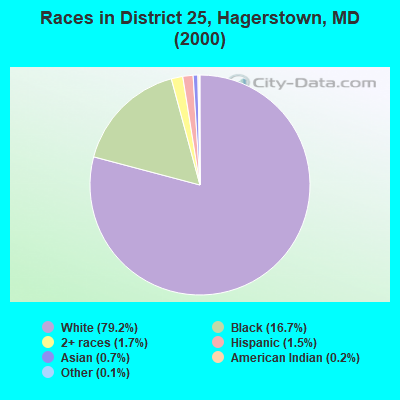
- 6,29879.2%White alone
- 1,32616.7%Black alone
- 1351.7%Two or more races
- 1161.5%Hispanic
- 520.7%Asian alone
- 150.2%American Indian alone
- 100.1%Other race alone
- 10.01%Native Hawaiian and Other
Pacific Islander alone
Races in District 25, Hagerstown detailed stats: ancestries, foreign born residents, place of birth
 Recent articles from our blog. Our writers, many of them Ph.D. graduates or candidates, create easy-to-read articles on a wide variety of topics.
Current Local Time: EST time zone
Land area: 1.40 square miles.
Population density: 6,230 people per square mile (high).
| District 25, Hagerstown: | 1.4% ($1,119) |
| Maryland: | 1.2% ($1,782) |
Nearest city with pop. 50,000+: Frederick, MD  (22.6 miles , pop. 52,767).
Nearest city with pop. 200,000+: Washington, DC (63.7 miles , pop. 572,059).
Nearest city with pop. 1,000,000+: Philadelphia, PA (139.3 miles , pop. 1,517,550).
Nearest cities:
), ), ), ), ), ), Latitude: 39.65 N, Longitude: 77.73 W

| Here: | 2.2% |
| Maryland: | 2.0% |
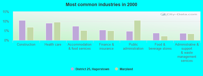
- Construction (10.4%)
- Health care (9.0%)
- Accommodation & food services (7.4%)
- Finance & insurance (5.5%)
- Public administration (4.7%)
- Food & beverage stores (3.9%)
- Administrative & support & waste management services (3.7%)
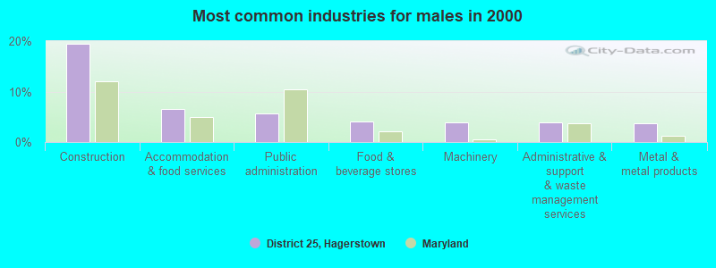
- Construction (19.4%)
- Accommodation & food services (6.6%)
- Public administration (5.6%)
- Food & beverage stores (4.1%)
- Machinery (3.9%)
- Administrative & support & waste management services (3.9%)
- Metal & metal products (3.7%)
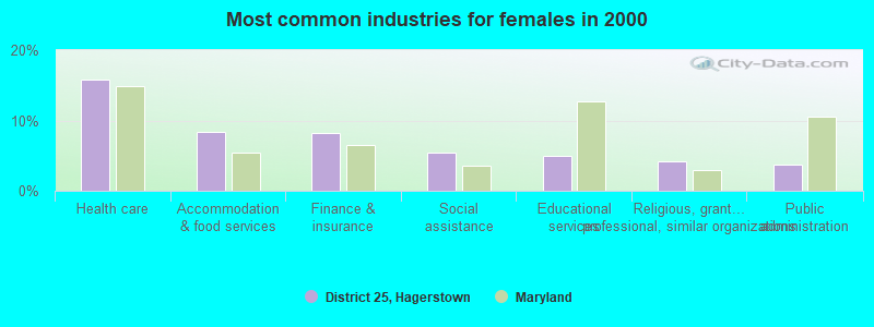
- Health care (15.8%)
- Accommodation & food services (8.3%)
- Finance & insurance (8.1%)
- Social assistance (5.4%)
- Educational services (4.9%)
- Religious, grantmaking, civic, professional, similar organizations (4.2%)
- Public administration (3.8%)
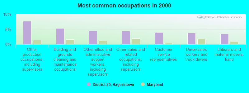
- Other production occupations, including supervisors (7.7%)
- Building and grounds cleaning and maintenance occupations (5.4%)
- Other office and administrative support workers, including supervisors (4.5%)
- Other sales and related occupations, including supervisors (4.4%)
- Customer service representatives (4.1%)
- Driver/sales workers and truck drivers (3.8%)
- Laborers and material movers, hand (3.5%)
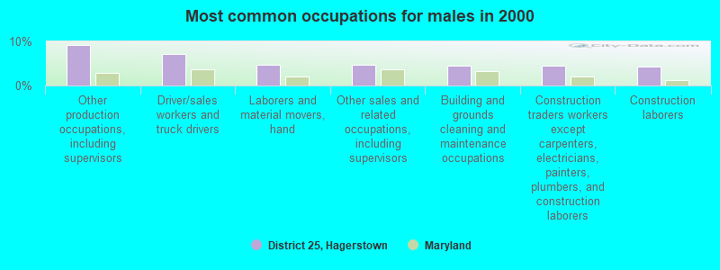
- Other production occupations, including supervisors (9.2%)
- Driver/sales workers and truck drivers (7.1%)
- Laborers and material movers, hand (4.7%)
- Other sales and related occupations, including supervisors (4.6%)
- Building and grounds cleaning and maintenance occupations (4.6%)
- Construction traders workers except carpenters, electricians, painters, plumbers, and construction laborers (4.5%)
- Construction laborers (4.3%)
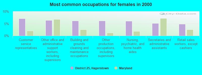
- Customer service representatives (7.1%)
- Other office and administrative support workers, including supervisors (6.4%)
- Building and grounds cleaning and maintenance occupations (6.2%)
- Other production occupations, including supervisors (6.2%)
- Nursing, psychiatric, and home health aides (6.1%)
- Secretaries and administrative assistants (5.1%)
- Retail sales workers, except cashiers (4.8%)
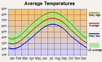
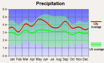
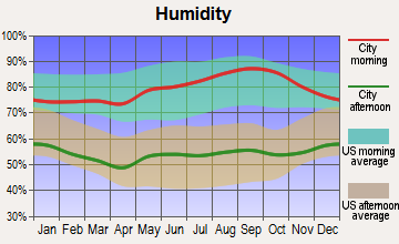
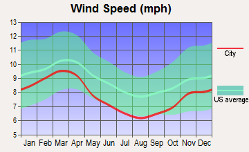
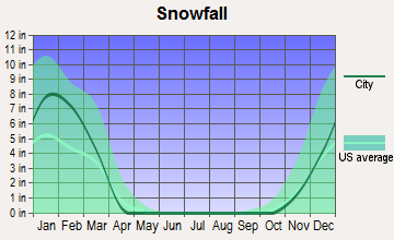
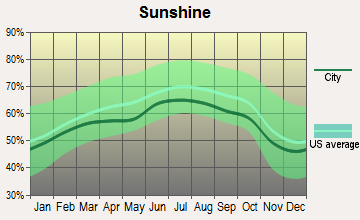
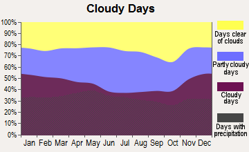
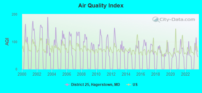
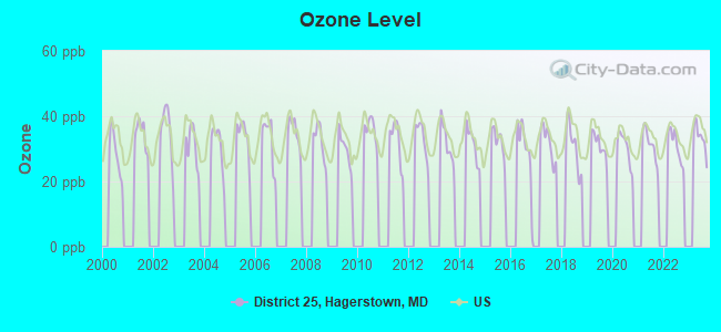
Average climate in District 25, Hagerstown, Maryland
Based on data reported by over 4,000 weather stations
Tornado activity:
District 25, Hagerstown-area historical tornado activity is near Maryland state average. It is 9% smaller than the overall U.S. average.
On 5/22/1983, a category F3 (max. wind speeds 158-206 mph) tornado 25.7 miles away from the District 25, Hagerstown city center caused between $5000 and $50,000 in damages.
On 4/16/1961, a category F3 tornado 29.8 miles away from the city center caused between $50,000 and $500,000 in damages.
Earthquake activity:
District 25, Hagerstown-area historical earthquake activity is significantly above Maryland state average. It is 55% smaller than the overall U.S. average.On 8/23/2011 at 17:51:04, a magnitude 5.8 (5.8 MW, Depth: 3.7 mi, Class: Moderate, Intensity: VI - VII) earthquake occurred 120.9 miles away from the city center
On 9/25/1998 at 19:52:52, a magnitude 5.2 (4.8 MB, 4.3 MS, 5.2 LG, 4.5 MW, Depth: 3.1 mi) earthquake occurred 189.4 miles away from District 25, Hagerstown center
On 1/16/1994 at 01:49:16, a magnitude 4.6 (4.6 MB, 4.6 LG, Depth: 3.1 mi, Class: Light, Intensity: IV - V) earthquake occurred 101.2 miles away from the city center
On 8/25/2011 at 05:07:52, a magnitude 4.5 (4.5 ML, Depth: 4.2 mi) earthquake occurred 118.5 miles away from the city center
On 1/31/1986 at 16:46:43, a magnitude 5.0 (5.0 MB) earthquake occurred 225.1 miles away from the city center
On 12/9/2003 at 20:59:18, a magnitude 4.5 (4.5 ML, Depth: 6.2 mi) earthquake occurred 131.3 miles away from District 25, Hagerstown center
Magnitude types: regional Lg-wave magnitude (LG), body-wave magnitude (MB), local magnitude (ML), surface-wave magnitude (MS), moment magnitude (MW)
Natural disasters:
The number of natural disasters in Washington County (15) is near the US average (15).Major Disasters (Presidential) Declared: 9
Emergencies Declared: 5
Causes of natural disasters: Hurricanes: 5, Floods: 3, Snowstorms: 3, Winter Storms: 3, Blizzard: 1, Heavy Rain: 1, Snowfall: 1, Storm: 1, Tropical Storm: 1, Other: 1 (Note: some incidents may be assigned to more than one category).
Hospitals and medical centers near District 25, Hagerstown:
- GARLOCK MANOR NURSING HOME (Nursing Home, about 1 miles away; HAGERSTOWN, MD)
- POTOMAC CENTER (Hospital, about 1 miles away; HAGERSTOWN, MD)
- COFFMAN NURSING HOME (Nursing Home, about 2 miles away; HAGERSTOWN, MD)
- WASHINGTON COUNTY HOSP. ECF (Nursing Home, about 2 miles away; HAGERSTOWN, MD)
- WESTERN MARYLAND CENTER (Hospital, about 2 miles away; HAGERSTOWN, MD)
- WESTERN MD HOSPITAL CENTER (Nursing Home, about 2 miles away; HAGERSTOWN, MD)
- JULIA MANOR HEALTH CARE CENTER (Nursing Home, about 2 miles away; HAGERSTOWN, MD)
Amtrak stations near District 25, Hagerstown:
- 6 miles: HAGERSTOWN (GREYHOUND STA., 10527 SHARPSTOWN PK.) - Bus Station . Services: enclosed waiting area, public restrooms, public payphones, snack bar.
- 19 miles: MARTINSBURG (229 E. MARTIN ST.) . Services: fully wheelchair accessible, enclosed waiting area, public restrooms, public payphones, paid short-term parking, taxi stand, public transit connection.
Colleges/universities with over 2000 students nearest to District 25, Hagerstown:
- Hagerstown Community College (about 4 miles; Hagerstown, MD; Full-time enrollment: 3,220)
- Shepherd University (about 16 miles; Shepherdstown, WV; FT enrollment: 3,745)
- Mount St Mary's University (about 21 miles; Emmitsburg, MD; FT enrollment: 2,313)
- Frederick Community College (about 22 miles; Frederick, MD; FT enrollment: 3,798)
- American Public University System (about 26 miles; Charles Town, WV; FT enrollment: 43,829)
- Gettysburg College (about 30 miles; Gettysburg, PA; FT enrollment: 2,772)
- Shippensburg University of Pennsylvania (about 31 miles; Shippensburg, PA; FT enrollment: 7,051)
Points of interest:
Notable locations in District 25, Hagerstown: Hagerstown Fire Department (A), Hagerstown Police Department (B), Western Enterprise Fire Company 4 (C), Pioneer Hook and Ladder Company 1 (D). Display/hide their locations on the map
Churches in District 25, Hagerstown include: Asbury United Methodist Church (A), Calvary Brethren Church (B), Calvary Holiness Church (C), Calvary Temple Apostolic Church (D), Christs Reformed Church (E), Church of God of Hagerstown (F), Ebenezer African Methodist Episcopal Church (G), First Baptist Church (H), Grace United Methodist Church (I). Display/hide their locations on the map
Cemeteries: Zion Cemetery (1), Saint Marys Graveyard (2), Ebenezer Cemetery (3). Display/hide their locations on the map
Parks in District 25, Hagerstown include: Potomac-Broadway Historic District (1), Hagerstown Commercial Core Historic District (2), Hellane Park (3), Wheaton Park (4). Display/hide their locations on the map
| This city: | 2.6 people |
| Maryland: | 2.6 people |
| This city: | 64.2% |
| Whole state: | 67.1% |
| This city: | 10.9% |
| Whole state: | 6.4% |
Likely homosexual households (counted as self-reported same-sex unmarried-partner households)
- Lesbian couples: 0.5% of all households
- Gay men: 0.4% of all households
| This city: | 18.4% |
| Whole state: | 8.5% |
| This city: | 10.3% |
| Whole state: | 4.2% |
People in group quarters in District 25, Hagerstown in 2010:
- 125 people in emergency and transitional shelters (with sleeping facilities) for people experiencing homelessness
- 19 people in other noninstitutional facilities
- 15 people in group homes intended for adults
People in group quarters in District 25, Hagerstown in 2000:
- 132 people in homes for the mentally retarded
- 64 people in other noninstitutional group quarters
- 39 people in other nonhousehold living situations
- 2 people in religious group quarters
For population 15 years and over in District 25, Hagerstown:
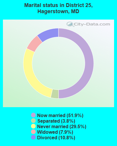
- Never married: 29.5%
- Now married: 51.9%
- Separated: 3.8%
- Widowed: 7.9%
- Divorced: 10.8%
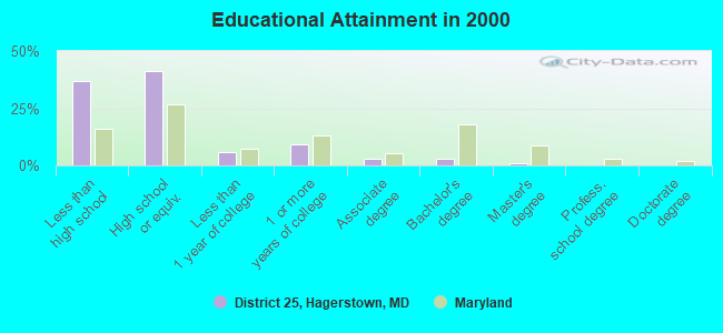
For population 25 years and over in District 25, Hagerstown:
- High school or higher: 63.1%
- Bachelor's degree or higher: 4.1%
- Graduate or professional degree: 1.1%
- Unemployed: 7.8%
- Mean travel time to work (commute): 17.7 minutes
| Here: | 10.7 |
| Maryland average: | 12.7 |
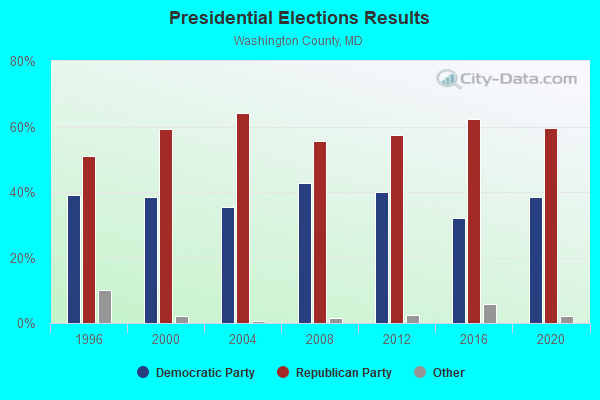
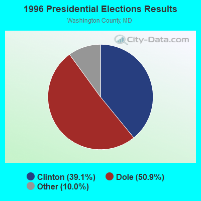
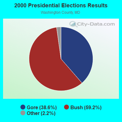
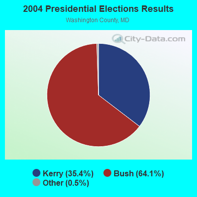
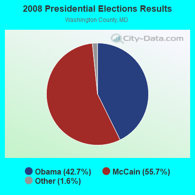
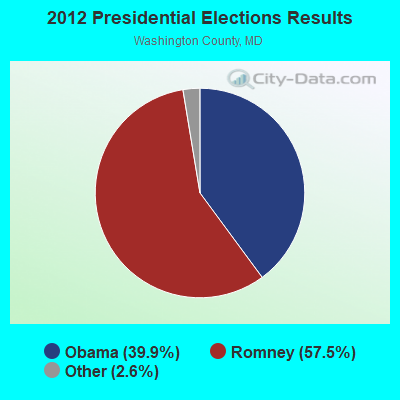
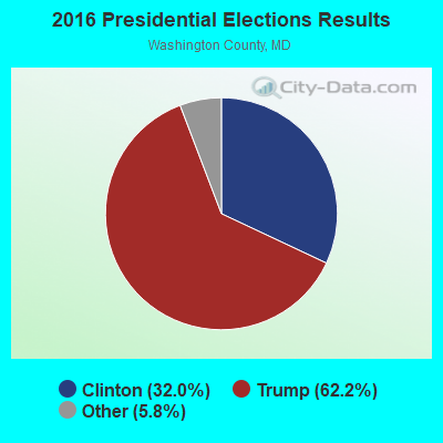
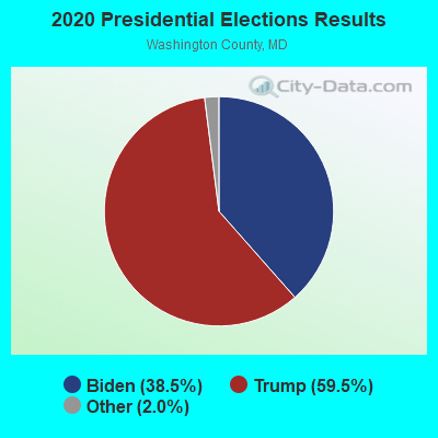
Graphs represent county-level data. Detailed 2008 Election Results
Religion statistics for District 25, Hagerstown, MD (based on Washington County data)
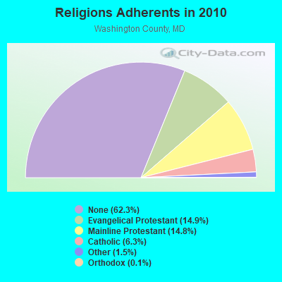
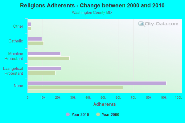
| Religion | Adherents | Congregations |
|---|---|---|
| Evangelical Protestant | 21,941 | 117 |
| Mainline Protestant | 21,837 | 79 |
| Catholic | 9,350 | 8 |
| Other | 2,244 | 11 |
| Orthodox | 163 | 2 |
| Black Protestant | 97 | 2 |
| None | 91,798 | - |
Food Environment Statistics:
| This county: | 1.73 / 10,000 pop. |
| State: | 1.96 / 10,000 pop. |
| Washington County: | 0.14 / 10,000 pop. |
| Maryland: | 0.07 / 10,000 pop. |
| Washington County: | 1.04 / 10,000 pop. |
| Maryland: | 1.22 / 10,000 pop. |
| This county: | 2.83 / 10,000 pop. |
| Maryland: | 2.05 / 10,000 pop. |
| Here: | 6.43 / 10,000 pop. |
| Maryland: | 5.40 / 10,000 pop. |
| Here: | 10.2% |
| Maryland: | 9.1% |
| Here: | 28.8% |
| Maryland: | 26.7% |
| Washington County: | 12.9% |
| Maryland: | 15.5% |
Strongest AM radio stations in District 25, Hagerstown:
- WJEJ (1240 AM; 1 kW; HAGERSTOWN, MD; Owner: HAGERSTOWN BROADCASTING COMPANY)
- WARK (1490 AM; 1 kW; HAGERSTOWN, MD; Owner: MANNING BROADCASTING, INC.)
- WHAG (1410 AM; 1 kW; HALFWAY, MD; Owner: DAME BROADCASTING, LLC)
- WCBM (680 AM; 50 kW; BALTIMORE, MD; Owner: WCBM MARYLAND, INC.)
- WMET (1150 AM; 50 kW; GAITHERSBURG, MD; Owner: BELTWAY ACQUISITION CORPORATION)
- WTRI (1520 AM; daytime; 17 kW; BRUNSWICK, MD; Owner: JMK COMMUNICATIONS, INC.)
- WBAL (1090 AM; 50 kW; BALTIMORE, MD; Owner: HEARST RADIO, INC.)
- WGOP (700 AM; daytime; 25 kW; WALKERSVILLE, MD; Owner: BIRACH BROADCASTING CORPORATION)
- WTEM (980 AM; 50 kW; WASHINGTON, DC; Owner: AMFM RADIO LICENSES, L.L.C.)
- WFMD (930 AM; 5 kW; FREDERICK, MD; Owner: CAPSTAR TX LIMITED PARTNERSHIP)
- WXTR (820 AM; 4 kW; FREDERICK, MD; Owner: BONNEVILLE HOLDING COMPANY)
- WTOP (1500 AM; 50 kW; WASHINGTON, DC; Owner: BONNEVILLE HOLDING COMPANY)
- WCBG (1590 AM; 5 kW; CHAMBERSBURG, PA; Owner: M. BELMONT VERSTANDIG, INC.)
Strongest FM radio stations in District 25, Hagerstown:
- W228AB (93.5 FM; PARAMOUNT, ETC., MD; Owner: FAMILY STATIONS, INC.)
- WDLD (96.7 FM; HALFWAY, MD; Owner: DAME BROADCASTING, LLC)
- WAYZ-FM (104.7 FM; HAGERSTOWN, MD; Owner: HJV LIMITED PARTNERSHIP)
- WETH (89.1 FM; HAGERSTOWN, MD; Owner: GREATER WASHINGTON EDUCATIONAL TELECOMMUNICATIONS ASSN.)
- WKMZ (95.9 FM; WILLIAMSPORT, MD; Owner: PRETTYMAN BROADCASTING COMPANY)
- WCRH (90.5 FM; WILLIAMSPORT, MD; Owner: CEDAR RIDGE CHILDREN'S HOME & SCHOOL, INC)
- WARX (106.9 FM; HAGERSTOWN, MD; Owner: MANNING BROADCASTING INC.)
- WFRE (99.9 FM; FREDERICK, MD; Owner: CAPSTAR TX LIMITED PARTNERSHIP)
- W219BX (91.7 FM; FREDERICK, MD; Owner: CEDAR RIDGE CHILDREN'S HOME & SCHOOL, INC)
- WEEO-FM (103.7 FM; MCCONNELLSBURG, PA; Owner: ALLEGHENY MOUNTAIN NETWORK)
- W219BE (91.7 FM; WAYNESBORO, PA; Owner: MARANATHA BIBLE INSTITUTE, NDBA)
- WWVZ (103.9 FM; BRADDOCK HEIGHTS, MD; Owner: BONNEVILLE HOLDING COMPANY)
- WQCM (94.3 FM; GREENCASTLE, PA; Owner: DAME BROADCASTING, LLC)
- WSRT (92.1 FM; MERCERSBURG, PA; Owner: M. BELMONT VERSTANDIG, INC.)
- WLTF (97.5 FM; MARTINSBURG, WV; Owner: PRETTYMAN BROADCASTING COMPANY)
- WAFY (103.1 FM; MIDDLETOWN, MD; Owner: FREDERICK BROADCASTING LLC)
- W228BA (93.5 FM; LEESBURG, VA; Owner: CSN INTERNATIONAL)
- WIKZ (95.1 FM; CHAMBERSBURG, PA; Owner: DAME BROADCASTING, LLC)
- WTRM (91.3 FM; WINCHESTER, VA; Owner: TIMBER RIDGE MINISTRIES, INC.)
- WINC-FM (92.5 FM; WINCHESTER, VA; Owner: MID ATLANTIC NETWORK, INC.)
TV broadcast stations around District 25, Hagerstown:
- W42CK (Channel 42; HAGERSTOWN, MD; Owner: THREE ANGELS BROADCASTING)
- WHAG-TV (Channel 25; HAGERSTOWN, MD; Owner: QUORUM OF MARYLAND LICENSE, LLC)
- WWPB (Channel 31; HAGERSTOWN, MD; Owner: MARYLAND PUBLIC BROADCASTING COMMISSION)
- WJAL (Channel 68; HAGERSTOWN, MD; Owner: ENTRAVISION HOLDINGS, LLC)
- W51CY (Channel 51; CHAMBERSBURG, PA; Owner: WBDC BROADCASTING, INC.)
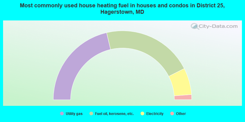
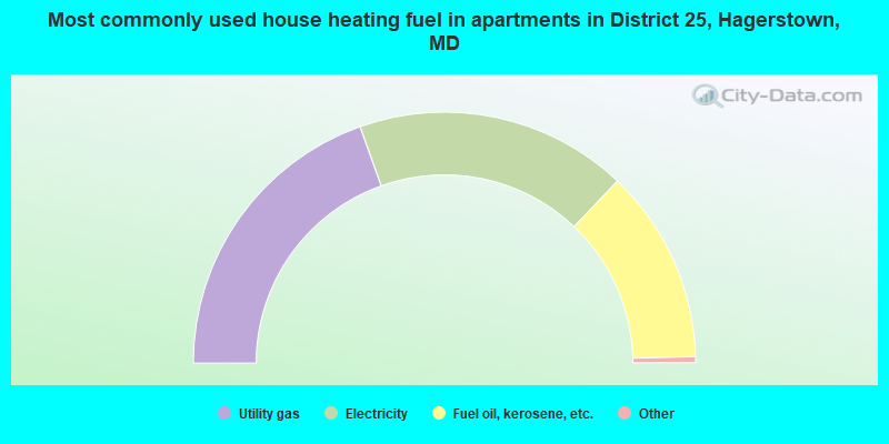
- 42.6%Utility gas
- 42.4%Fuel oil, kerosene, etc.
- 12.5%Electricity
- 1.6%Bottled, tank, or LP gas
- 0.8%Wood
- 39.1%Utility gas
- 35.1%Electricity
- 25.0%Fuel oil, kerosene, etc.
- 0.4%Other fuel
- 0.4%Bottled, tank, or LP gas
District 25, Hagerstown compared to Maryland state average:
- Median household income below state average.
- Median house value below state average.
- Unemployed percentage below state average.
- Black race population percentage below state average.
- Hispanic race population percentage significantly below state average.
- Foreign-born population percentage significantly below state average.
- Renting percentage above state average.
- Length of stay since moving in significantly above state average.
- Number of rooms per house significantly below state average.
- House age significantly below state average.
- Number of college students below state average.
- Percentage of population with a bachelor's degree or higher significantly below state average.
District 25, Hagerstown on our top lists:
- #2 on the list of "Top 101 cities with largest percentage of females in occupations: customer service representatives (population 5,000+)"
- #3 on the list of "Top 101 cities with largest percentage of males in industries: leather and allied products (population 5,000+)"
- #7 on the list of "Top 101 cities with largest percentage of females in industries: leather and allied products (population 5,000+)"
- #9 on the list of "Top 101 cities with largest percentage of males in industries: office supplies and stationery stores (population 5,000+)"
- #10 on the list of "Top 101 cities with largest percentage of males in occupations: electricians (population 5,000+)"
- #21 on the list of "Top 101 cities with largest percentage of females in industries: religious, grantmaking, civic, professional, and similar organizations (population 5,000+)"
- #34 on the list of "Top 101 cities with largest percentage of females in occupations: plant and system operators (population 5,000+)"
- #36 on the list of "Top 101 cities with largest percentage of males in industries: religious, grantmaking, civic, professional, and similar organizations (population 5,000+)"
- #42 on the list of "Top 101 cities with largest percentage of males in occupations: construction laborers (population 5,000+)"
- #42 on the list of "Top 101 cities with largest percentage of females in industries: petroleum and coal products (population 5,000+)"
- #48 on the list of "Top 101 cities with largest percentage of females in industries: nonmetallic mineral products (population 5,000+)"
- #50 on the list of "Top 101 cities with largest percentage of females in occupations: nursing, psychiatric, and home health aides (population 5,000+)"
- #50 on the list of "Top 101 cities with largest percentage of females in occupations: textile, apparel, and furnishings workers (population 5,000+)"
- #53 on the list of "Top 101 cities with the most people taking a taxi to work (population 5,000+)"
- #53 on the list of "Top 101 cities with largest percentage of females in industries: furniture and home furnishing merchant wholesalers (population 5,000+)"
- #55 on the list of "Top 101 cities with largest percentage of males in industries: rail transportation (population 5,000+)"
- #56 on the list of "Top 101 cities with largest percentage of females in industries: electrical and electronic goods merchant wholesalers (population 5,000+)"
- #63 on the list of "Top 101 cities with largest percentage of males in industries: hardware, plumbing and heating equipment, and supplies merchant wholesalers (population 5,000+)"
- #67 on the list of "Top 101 cities with largest percentage of females in industries: apparel (population 5,000+)"
- #67 on the list of "Top 101 cities with the largest percentage of people in homes for the mentally retarded (population 1,000+)"
- #31 (21740) on the list of "Top 101 zip codes with the most beauty salons in 2005"
- #67 on the list of "Top 101 counties with the lowest percentage of residents relocating to foreign countries in 2011"
- #77 on the list of "Top 101 counties with the lowest percentage of residents that exercised in the past month"