El Paso, Wisconsin
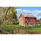
Submit your own pictures of this town and show them to the world
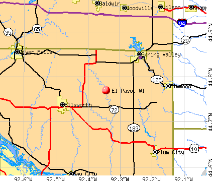
- OSM Map
- General Map
- Google Map
- MSN Map
Population change since 2000: -1.3%
 |
| Males: 357 | |
| Females: 324 |
| Median resident age: | 41.7 years |
| Wisconsin median age: | 42.6 years |
Zip codes: 54011.
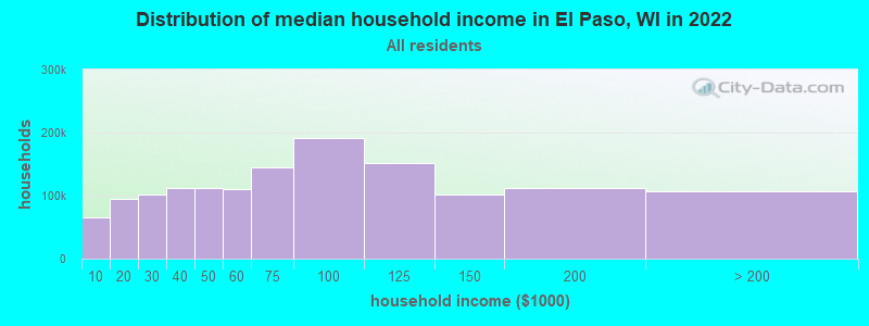
| El Paso: | $81,033 |
| WI: | $70,996 |
Estimated per capita income in 2022: $38,065 (it was $19,441 in 2000)
El Paso town income, earnings, and wages data
Estimated median house or condo value in 2022: $342,807 (it was $141,300 in 2000)
| El Paso: | $342,807 |
| WI: | $252,800 |
Detailed information about poverty and poor residents in El Paso, WI
Compare current foreclosures near El Paso, WI:
| Photo | Address | Area | Beds / Baths | Price | Details |
|---|---|---|---|---|---|

|
#1
Phelps St
Red Wing, MN 55066
|
1,456 sq. feet
|
2 baths 4 beds |
show details | |

|
#2
Central Ave
Red Wing, MN 55066
|
1,515 sq. feet
|
1 baths 2 beds |
show details | |

|
#3
Norwood St
Red Wing, MN 55066
|
1,622 sq. feet
|
1 baths 2 beds |
show details | |

|
#4
Plum St
Red Wing, MN 55066
|
967 sq. feet
|
1 baths 3 beds |
show details | |

|
#5
College Ave
Red Wing, MN 55066
|
1,020 sq. feet
|
1 baths 2 beds |
show details | |

|
#6
9th St
Red Wing, MN 55066
|
1,188 sq. feet
|
1 baths 3 beds |
show details | |

|
#7
Norwood St
Red Wing, MN 55066
|
859 sq. feet
|
- baths - beds |
show details | |

|
#8
950th St
River Falls, WI 54022
|
- sq. feet
|
- baths - beds |
show details | |

|
#9
West Ave
Red Wing, MN 55066
|
1,252 sq. feet
|
- baths - beds |
show details | |

|
#10
Norwood St
Red Wing, MN 55066
|
1,149 sq. feet
|
- baths - beds |
show details |
| Photo | Address | Area | Beds / Baths | Price | Details |
|---|---|---|---|---|---|

|
#11
11th Ave
Baldwin, WI 54002
|
- sq. feet
|
- baths - beds |
show details | |

|
#12
Seymour St
Red Wing, MN 55066
|
1,568 sq. feet
|
- baths - beds |
show details | |

|
#13
450th St
Ellsworth, WI 54011
|
- sq. feet
|
- baths - beds |
show details | |

|
#14
940th St, Apt 1
River Falls, WI 54022
|
- sq. feet
|
- baths - beds |
show details | |

|
#15
Roosevelt Ave
Red Wing, MN 55066
|
1,049 sq. feet
|
- baths - beds |
show details | |

|
#16
Cemetery Rd Apt 8
River Falls, WI 54022
|
- sq. feet
|
- baths - beds |
show details | |

|
#17
Hi Park Ave
Red Wing, MN 55066
|
1,412 sq. feet
|
- baths - beds |
show details | |

|
#18
W Maple Ave
Red Wing, MN 55066
|
- sq. feet
|
- baths - beds |
show details | |

|
#19
Tee Up Ln
Red Wing, MN 55066
|
2,680 sq. feet
|
- baths - beds |
show details | |

|
#20
Carol Dr
Red Wing, MN 55066
|
1,089 sq. feet
|
- baths - beds |
show details |
| Photo | Address | Area | Beds / Baths | Price | Details |
|---|---|---|---|---|---|

|
#21
12th Ave
Baldwin, WI 54002
|
- sq. feet
|
- baths - beds |
show details | |

|
#22
Foursome St
Red Wing, MN 55066
|
1,244 sq. feet
|
- baths - beds |
show details | |

|
#23
Newton St
Baldwin, WI 54002
|
- sq. feet
|
- baths - beds |
show details | |

|
#24
Cherry St
Red Wing, MN 55066
|
2,128 sq. feet
|
- baths - beds |
show details | |

|
#25
Franklin St
Red Wing, MN 55066
|
- sq. feet
|
- baths - beds |
show details | |

|
#26
450th Ave
Ellsworth, WI 54011
|
- sq. feet
|
- baths - beds |
show details | |

|
#27
250th St
Woodville, WI 54028
|
- sq. feet
|
- baths - beds |
show details | |

|
#28
Beltline Rd
Spring Valley, WI 54767
|
- sq. feet
|
- baths - beds |
show details | |

|
#29
S Maple St
Ellsworth, WI 54011
|
- sq. feet
|
- baths - beds |
show details | |

|
#30
Newman Ave
Spring Valley, WI 54767
|
- sq. feet
|
- baths - beds |
show details |
| Photo | Address | Area | Beds / Baths | Price | Details |
|---|---|---|---|---|---|

|
#31
747th St
River Falls, WI 54022
|
- sq. feet
|
- baths - beds |
show details | |

|
#32
18th Ave
Baldwin, WI 54002
|
- sq. feet
|
- baths - beds |
show details | |

|
#33
174th Ave
Hager City, WI 54014
|
- sq. feet
|
- baths - beds |
show details | |

|
#34
Westervelt Avenue Way W
Frontenac, MN 55026
|
1,140 sq. feet
|
- baths - beds |
show details | |

|
#35
S Main St Apt 2
Woodville, WI 54028
|
- sq. feet
|
- baths - beds |
show details | |

|
#36
Potter St
Red Wing, MN 55066
|
1,036 sq. feet
|
- baths - beds |
show details | |

|
#37
Bush St Apt 211
Red Wing, MN 55066
|
- sq. feet
|
- baths - beds |
show details | |

|
#38
20th St
Red Wing, MN 55066
|
967 sq. feet
|
- baths - beds |
show details | |

|
#39
S Church St Apt 20
Woodville, WI 54028
|
- sq. feet
|
- baths - beds |
show details | |

|
#40
9th St
Red Wing, MN 55066
|
- sq. feet
|
- baths - beds |
show details |
| Photo | Address | Area | Beds / Baths | Price | Details |
|---|---|---|---|---|---|

|
#41
Arkin St
Red Wing, MN 55066
|
- sq. feet
|
- baths - beds |
show details | |

|
#42
Us Highway 12
Woodville, WI 54028
|
- sq. feet
|
- baths - beds |
show details | |

|
#43
Finvold St
Woodville, WI 54028
|
- sq. feet
|
- baths - beds |
show details | |

|
#44
W Park St
Baldwin, WI 54002
|
- sq. feet
|
- baths - beds |
show details | |

|
#45
30th Ave
Baldwin, WI 54002
|
- sq. feet
|
- baths - beds |
show details | |

|
#46
S Main St
Elmwood, WI 54740
|
- sq. feet
|
- baths - beds |
show details | |

|
#47
Burton St
Red Wing, MN 55066
|
- sq. feet
|
- baths - beds |
show details | |

|
#48
E Johnson St
River Falls, WI 54022
|
- sq. feet
|
- baths - beds |
show details | |

|
#49
Hilden Dr
Ellsworth, WI 54011
|
- sq. feet
|
- baths - beds |
show details | |

|
Check over 1 million property listings on Foreclosure.com!
|
browse all offers | |||

- 66197.1%White alone
- 172.5%Hispanic
- 10.1%Black alone
- 10.1%American Indian alone
- 10.1%Two or more races
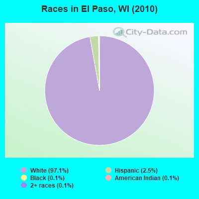
Races in El Paso detailed stats: ancestries, foreign born residents, place of birth
 Recent articles from our blog. Our writers, many of them Ph.D. graduates or candidates, create easy-to-read articles on a wide variety of topics.

 | consolidated Milwaukee County? (5 replies) |
| Is Milwaukee really that dangerous? (130 replies) |
| Milwaukee one of the poorest cities in America (67 replies) |
| Friendliness? (125 replies) |
| don't move to wisconsin (237 replies) |
| Why does Hurley have so many strip clubs? (16 replies) |
Latest news from El Paso, WI collected exclusively by city-data.com from local newspapers, TV, and radio stations
Ancestries: German (53.9%), Norwegian (24.6%), Irish (14.2%), Swedish (6.8%), English (4.8%), Czech (3.5%).
Current Local Time: CST time zone
Elevation: 910 feet
Land area: 35.1 square miles.
Population density: 19 people per square mile (very low).
2 residents are foreign born
| This town: | 0.3% |
| Wisconsin: | 3.6% |
| El Paso town: | 1.0% ($1,431) |
| Wisconsin: | 2.0% ($2,245) |
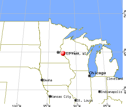
Nearest city with pop. 50,000+: Eau Claire, WI  (41.3 miles , pop. 61,704).
Nearest city with pop. 200,000+: St. Paul, MN (41.7 miles , pop. 287,151).
Nearest city with pop. 1,000,000+: Chicago, IL (307.6 miles , pop. 2,896,016).
Nearest cities:
), ), ), ), ), )Latitude: 44.73 N, Longitude: 92.32 W
Area code commonly used in this area: 715

| Here: | 3.5% |
| Wisconsin: | 2.7% |
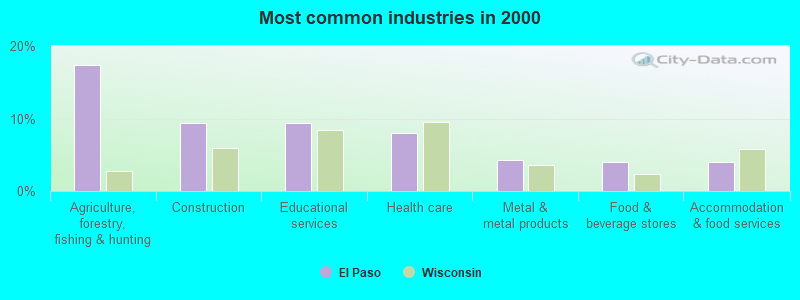
- Agriculture, forestry, fishing & hunting (17.4%)
- Construction (9.4%)
- Educational services (9.4%)
- Health care (7.9%)
- Metal & metal products (4.2%)
- Food & beverage stores (4.0%)
- Accommodation & food services (4.0%)
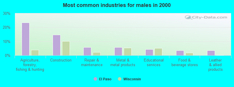
- Agriculture, forestry, fishing & hunting (23.5%)
- Construction (14.6%)
- Repair & maintenance (5.8%)
- Metal & metal products (5.8%)
- Educational services (4.4%)
- Food & beverage stores (3.5%)
- Leather & allied products (3.5%)
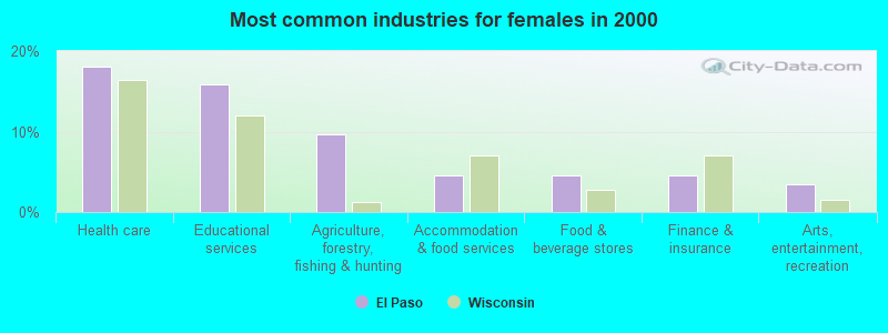
- Health care (18.1%)
- Educational services (15.8%)
- Agriculture, forestry, fishing & hunting (9.6%)
- Accommodation & food services (4.5%)
- Food & beverage stores (4.5%)
- Finance & insurance (4.5%)
- Arts, entertainment, recreation (3.4%)

- Farmers and farm managers (13.9%)
- Other sales and related occupations, including supervisors (4.7%)
- Other production occupations, including supervisors (4.0%)
- Preschool, kindergarten, elementary, and middle school teachers (3.7%)
- Nursing, psychiatric, and home health aides (3.5%)
- Other office and administrative support workers, including supervisors (3.2%)
- Carpenters (3.2%)
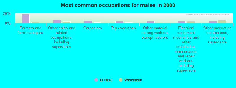
- Farmers and farm managers (19.0%)
- Other sales and related occupations, including supervisors (7.5%)
- Carpenters (5.8%)
- Top executives (4.4%)
- Other material moving workers, except laborers (4.4%)
- Electrical equipment mechanics and other installation, maintenance, and repair workers, including supervisors (4.4%)
- Other production occupations, including supervisors (4.0%)

- Nursing, psychiatric, and home health aides (7.9%)
- Farmers and farm managers (7.3%)
- Preschool, kindergarten, elementary, and middle school teachers (5.6%)
- Secretaries and administrative assistants (5.6%)
- Other office and administrative support workers, including supervisors (5.6%)
- Health technologists and technicians (5.1%)
- Information and record clerks, except customer service representatives (5.1%)
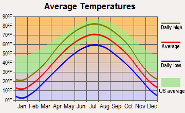
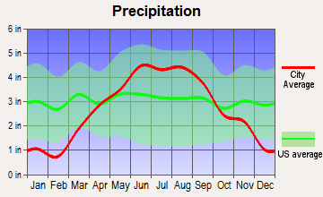
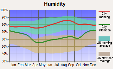
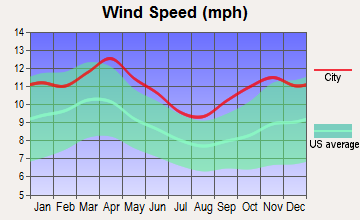
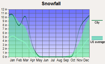
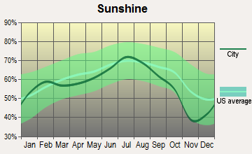
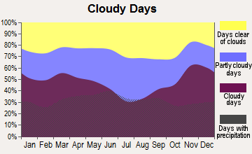
Average climate in El Paso, Wisconsin
Based on data reported by over 4,000 weather stations
Tornado activity:
El Paso-area historical tornado activity is near Wisconsin state average. It is 24% greater than the overall U.S. average.
On 6/4/1958, a category F5 (max. wind speeds 261-318 mph) tornado 11.7 miles away from the El Paso town center killed 21 people and injured 74 people and caused between $5,000,000 and $50,000,000 in damages.
On 9/12/1951, a category F3 (max. wind speeds 158-206 mph) tornado 13.9 miles away from the town center injured one person and caused between $50,000 and $500,000 in damages.
Earthquake activity:
El Paso-area historical earthquake activity is significantly above Wisconsin state average. It is 64% smaller than the overall U.S. average.On 7/9/1975 at 14:54:15, a magnitude 4.6 (4.6 MB, Class: Light, Intensity: IV - V) earthquake occurred 192.4 miles away from the city center
On 6/5/1993 at 01:24:53, a magnitude 4.1 (4.1 LG, Depth: 6.2 mi) earthquake occurred 204.1 miles away from the city center
On 3/4/1983 at 06:32:18, a magnitude 4.6 (4.4 MB, 4.6 LG, 4.4 ML) earthquake occurred 351.4 miles away from El Paso center
On 6/28/2004 at 06:10:52, a magnitude 4.2 (4.2 MW, Depth: 6.2 mi) earthquake occurred 284.7 miles away from El Paso center
On 10/20/1995 at 15:57:18, a magnitude 3.7 (3.7 LG, Depth: 3.1 mi, Class: Light, Intensity: II - III) earthquake occurred 232.7 miles away from the city center
On 2/9/1994 at 08:45:35, a magnitude 3.1 (3.1 LG, Depth: 3.1 mi) earthquake occurred 132.5 miles away from El Paso center
Magnitude types: regional Lg-wave magnitude (LG), body-wave magnitude (MB), local magnitude (ML), moment magnitude (MW)
Natural disasters:
The number of natural disasters in Pierce County (12) is smaller than the US average (15).Major Disasters (Presidential) Declared: 10
Emergencies Declared: 2
Causes of natural disasters: Floods: 8, Storms: 6, Tornadoes: 5, Heavy Rains: 2, Drought: 1, Flash Flood: 1, Hurricane: 1, Wind: 1, Other: 1 (Note: some incidents may be assigned to more than one category).
Hospitals and medical centers near El Paso:
- PIETY PLACE (Nursing Home, about 8 miles away; ELLSWORTH, WI)
- PIERCE CTY HOME CARE (Home Health Center, about 8 miles away; ELLSWORTH, WI)
- ELLSWORTH CARE CTR (Nursing Home, about 9 miles away; ELLSWORTH, WI)
- HERITAGE OF ELMWOOD NH (Nursing Home, about 10 miles away; ELMWOOD, WI)
- PLUM CITY CARE CTR (Nursing Home, about 10 miles away; PLUM CITY, WI)
- BALDWIN AREA MED CTR Critical Access Hospitals (about 11 miles away; BALDWIN, WI)
- PARK VIEW HOME (Nursing Home, about 16 miles away; WOODVILLE, WI)
Operable nuclear power plants near El Paso:
- 17 miles: Prairie Island 1 and 2 in Red Wing, MN.
Colleges/universities with over 2000 students nearest to El Paso:
- University of Wisconsin-River Falls (about 17 miles; River Falls, WI; Full-time enrollment: 5,868)
- University of Wisconsin-Stout (about 23 miles; Menomonie, WI; FT enrollment: 8,120)
- Inver Hills Community College (about 37 miles; Inver Grove Heights, MN; FT enrollment: 4,049)
- Dakota County Technical College (about 38 miles; Rosemount, MN; FT enrollment: 2,478)
- Century College (about 39 miles; White Bear Lake, MN; FT enrollment: 7,393)
- Metropolitan State University (about 40 miles; Saint Paul, MN; FT enrollment: 6,159)
- Chippewa Valley Technical College (about 41 miles; Eau Claire, WI; FT enrollment: 4,038)
Points of interest:
Cemeteries: Lost Creek Cemetery (1), Saint Josephs Catholic Cemetery (2). Display/hide their locations on the map
Creeks: Cave Creek (A), Brush Creek (B), Lost Creek (C). Display/hide their locations on the map
| This town: | 2.7 people |
| Wisconsin: | 2.4 people |
| This town: | 78.7% |
| Whole state: | 64.4% |
| This town: | 6.3% |
| Whole state: | 7.3% |
No gay or lesbian households reported
| This town: | 4.9% |
| Whole state: | 8.7% |
| This town: | 2.3% |
| Whole state: | 3.7% |
For population 15 years and over in El Paso:
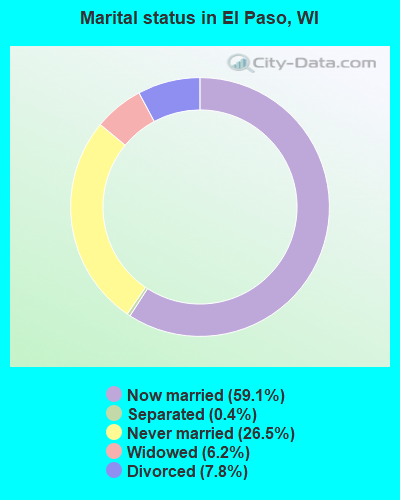
- Never married: 26.5%
- Now married: 59.1%
- Separated: 0.4%
- Widowed: 6.2%
- Divorced: 7.8%
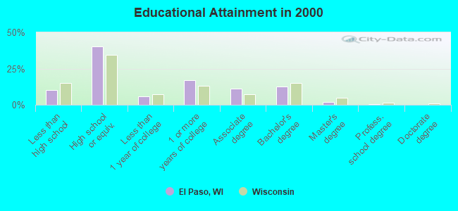
For population 25 years and over in El Paso:
- High school or higher: 89.6%
- Bachelor's degree or higher: 15.5%
- Graduate or professional degree: 3.0%
- Unemployed: 2.4%
- Mean travel time to work (commute): 30.3 minutes
| Here: | 9.7 |
| Wisconsin average: | 11.0 |
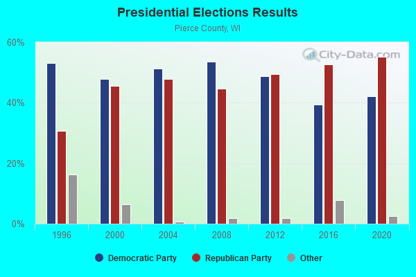

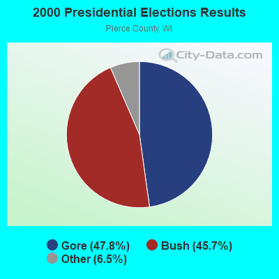


Graphs represent county-level data. Detailed 2008 Election Results
Religion statistics for El Paso, WI (based on Pierce County data)
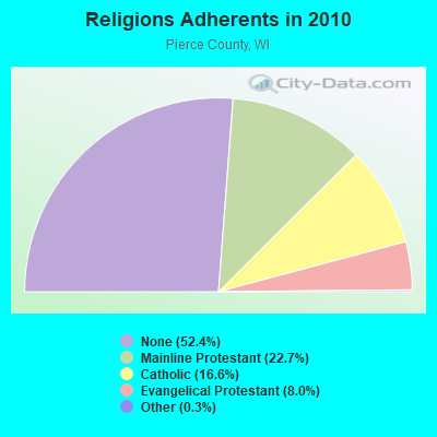
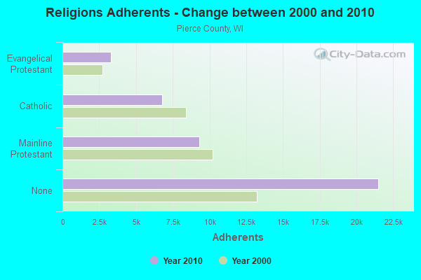
| Religion | Adherents | Congregations |
|---|---|---|
| Mainline Protestant | 9,316 | 29 |
| Catholic | 6,790 | 6 |
| Evangelical Protestant | 3,275 | 20 |
| Other | 137 | 2 |
| None | 21,501 | - |
Food Environment Statistics:
| Pierce County: | 1.51 / 10,000 pop. |
| Wisconsin: | 1.86 / 10,000 pop. |
| Pierce County: | 3.77 / 10,000 pop. |
| State: | 4.12 / 10,000 pop. |
| Here: | 7.29 / 10,000 pop. |
| Wisconsin: | 8.64 / 10,000 pop. |
| This county: | 6.4% |
| State: | 7.6% |
| Pierce County: | 26.7% |
| State: | 27.5% |
| Pierce County: | 10.4% |
| State: | 13.0% |
Strongest AM radio stations in El Paso:
- WCTS (1030 AM; 50 kW; MAPLEWOOD, MN; Owner: CNTL. BAPT. THEO/AL SEMI MINNEAPOLIS)
- WDGY (630 AM; 8 kW; HUDSON, WI; Owner: 630 RADIO, INCORPORATED)
- KSTP (1500 AM; 50 kW; ST. PAUL, MN; Owner: KSTP-AM, LLC (DELAWARE))
- KTIS (900 AM; 25 kW; MINNEAPOLIS, MN; Owner: NORTHWESTERN COLLEGE)
- WMEQ (880 AM; 10 kW; MENOMONIE, WI; Owner: CAPSTAR TX LIMITED PARTNERSHIP)
- WCCO (830 AM; 50 kW; MINNEAPOLIS, MN; Owner: INFINITY MEDIA CORPORATION)
- KFAN (1130 AM; 50 kW; MINNEAPOLIS, MN; Owner: AMFM RADIO LICENSES, L.L.C.)
- WEBC (560 AM; 50 kW; DULUTH, MN)
- WIXK (1590 AM; daytime; 5 kW; NEW RICHMOND, WI; Owner: WIXK-AM, LLC)
- WMGT (1220 AM; 5 kW; STILLWATER, MN; Owner: ENDURANCE BROADCASTING, LLC)
- WAYY (790 AM; 5 kW; EAU CLAIRE, WI; Owner: MAVERICK MEDIA OF EAU CLAIRE LICENSE LLC)
- WXCE (1260 AM; 5 kW; AMERY, WI; Owner: LAKE COUNTRY BROADCASTING CORPORATION)
- KCUE (1250 AM; 1 kW; RED WING, MN; Owner: SORENSON BROADCASTING CORP.)
Strongest FM radio stations in El Paso:
- W211AY (90.1 FM; MENOMONIE, WI; Owner: CALVARY CHAPEL OF TWIN FALLS, INC.)
- WVSS (90.7 FM; MENOMONIE, WI; Owner: BD. OF REGENTS, UNIVERSITY OF WISCONSIN SYSTEM)
- KWNG (105.9 FM; RED WING, MN; Owner: SORENSON BROADCASTING CORPORATION)
- WHWC (88.3 FM; MENOMONIE, WI; Owner: STATE OF WISCONSIN - EDUCATIONAL COMMUNICATIONS BOARD)
- WXPT (104.1 FM; ST. LOUIS PARK, MN; Owner: THE AUDIO HOUSE, INC.)
- KNOW-FM (91.1 FM; MINNEAPOLIS-ST. PAUL, MN; Owner: MINNESOTA PUBLIC RADIO)
- WLTE (102.9 FM; MINNEAPOLIS, MN; Owner: INFINITY MEDIA CORPORATION)
- WDMO (95.9 FM; DURAND, WI; Owner: ZOE COMMUNICATIONS, INC.)
- KSTP-FM (94.5 FM; ST. PAUL, MN; Owner: KSTP-FM, LLC, A DELAWARE LLC)
- KLCH (94.9 FM; LAKE CITY, MN; Owner: WAITT RADIO, INC.)
- KEEY-FM (102.1 FM; ST. PAUL, MN; Owner: AMFM RADIO LICENSES, L.L.C.)
- KTIS-FM (98.5 FM; MINNEAPOLIS, MN; Owner: NORTHWESTERN COLLEGE)
- KDWB-FM (101.3 FM; RICHFIELD, MN; Owner: AMFM RADIO LICENSES, L.L.C.)
- KQRS-FM (92.5 FM; GOLDEN VALLEY, MN; Owner: KQRS, Inc.)
- KSJN (99.5 FM; MINNEAPOLIS, MN; Owner: MINNESOTA PUBLIC RADIO)
- KXXR (93.7 FM; MINNEAPOLIS, MN; Owner: KQRS, INC.)
- WEVR-FM (106.3 FM; RIVER FALLS, WI; Owner: HANTEN BROADCASTING COMPANY, INC.)
- KMFX-FM (102.5 FM; LAKE CITY, MN; Owner: CLEAR CHANNEL BROADCASTING LICENSES, INC.)
- WCAL (89.3 FM; NORTHFIELD, MN; Owner: ST. OLAF COLLEGE)
- K297AF (107.3 FM; RED WING, MN; Owner: KRCH OF MINNESOTA, INC.)
TV broadcast stations around El Paso:
- WHWC-TV (Channel 28; MENOMONIE, WI; Owner: STATE OF WISCONSIN - EDUCATIONAL COMMUNICATIONS BOARD)
- KMSP-TV (Channel 9; MINNEAPOLIS, MN; Owner: FOX TELEVISION STATIONS, INC.)
- KARE (Channel 11; MINNEAPOLIS, MN; Owner: MULTIMEDIA HOLDINGS CORPORATION)
- KSTP-TV (Channel 5; ST. PAUL, MN; Owner: HUBBARD BROADCASTING, INC.)
- KTCA-TV (Channel 2; ST. PAUL, MN; Owner: TWIN CITIES PUBLIC TELEVISION, INC.)
- WCCO-TV (Channel 4; MINNEAPOLIS, MN; Owner: CBS BROADCASTING INC.)
- KTCI-TV (Channel 17; ST. PAUL, MN; Owner: TWIN CITIES PUBLIC TELEVISION, INC.)
- KSTC-TV (Channel 45; MINNEAPOLIS, MN; Owner: HUBBARD BROADCASTING, INC.)
- KMWB (Channel 23; MINNEAPOLIS, MN; Owner: KLGT LICENSEE, LLC)
- WFTC (Channel 29; MINNEAPOLIS, MN; Owner: FOX TELEVISION STATIONS, INC.)
- KXLT-TV (Channel 47; ROCHESTER, MN; Owner: SHOCKLEY BROADCASTING, LLC)
- WQOW-TV (Channel 18; EAU CLAIRE, WI; Owner: WXOW-WQOW TELEVISION, INC.)
- W55AP (Channel 55; RIVER FALLS, WI; Owner: STATE OF WISCONSIN - EDUCATIONAL COMMUNICATIONS BOARD)
- National Bridge Inventory (NBI) Statistics
- 16Number of bridges
- 285ft / 86.9mTotal length
- $481,000Total costs
- 17,171Total average daily traffic
- 1,224Total average daily truck traffic
- 21,007Total future (year 2039) average daily traffic
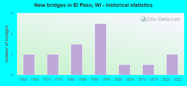
- New bridges - historical statistics
- 21960-1969
- 21970-1979
- 31980-1989
- 51990-1999
- 12000-2009
- 12010-2019
- 22020-2022
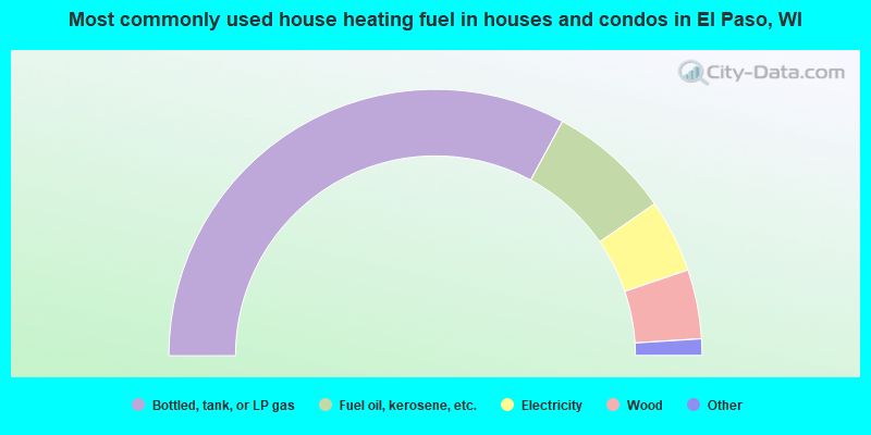
- 65.8%Bottled, tank, or LP gas
- 14.9%Fuel oil, kerosene, etc.
- 8.9%Electricity
- 8.4%Wood
- 1.0%Utility gas
- 1.0%Coal or coke
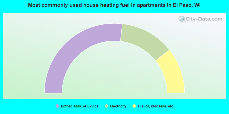
- 53.6%Bottled, tank, or LP gas
- 25.0%Electricity
- 21.4%Fuel oil, kerosene, etc.
El Paso compared to Wisconsin state average:
- Unemployed percentage significantly below state average.
- Black race population percentage significantly below state average.
- Hispanic race population percentage significantly below state average.
- Foreign-born population percentage significantly below state average.
- Renting percentage significantly below state average.
- Length of stay since moving in significantly above state average.
- Number of rooms per house significantly below state average.
- House age significantly below state average.