Erin Prairie, Wisconsin
Submit your own pictures of this town and show them to the world
- OSM Map
- Google Map
- MSN Map
Population change since 2000: +4.6%
 |
| Males: 359 | |
| Females: 329 |
| Median resident age: | 43.9 years |
| Wisconsin median age: | 42.6 years |
Zip codes: 54017.
| Erin Prairie: | $115,395 |
| WI: | $70,996 |
Estimated per capita income in 2022: $44,595 (it was $23,772 in 2000)
Erin Prairie town income, earnings, and wages data
Estimated median house or condo value in 2022: $396,738 (it was $157,100 in 2000)
| Erin Prairie: | $396,738 |
| WI: | $252,800 |
Mean prices in 2022: all housing units: $389,131; detached houses: $412,715; townhouses or other attached units: $252,608; in 2-unit structures: $215,935; in 3-to-4-unit structures: $266,397; in 5-or-more-unit structures: $383,008; mobile homes: $70,238
Detailed information about poverty and poor residents in Erin Prairie, WI


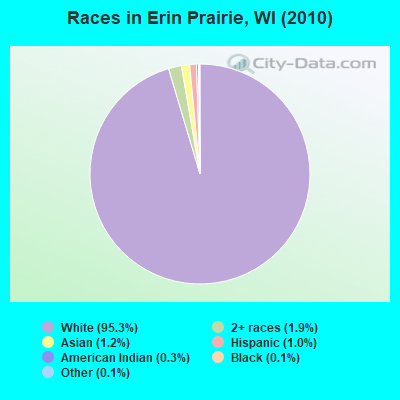
- 65695.3%White alone
- 131.9%Two or more races
- 81.2%Asian alone
- 71.0%Hispanic
- 20.3%American Indian alone
- 10.1%Black alone
- 10.1%Other race alone
Races in Erin Prairie detailed stats: ancestries, foreign born residents, place of birth
 Recent articles from our blog. Our writers, many of them Ph.D. graduates or candidates, create easy-to-read articles on a wide variety of topics.
Ancestries: German (52.1%), Norwegian (27.8%), Irish (15.2%), Swedish (8.5%), Polish (7.0%), French (5.3%).
Current Local Time: CST time zone
Land area: 35.5 square miles.
Population density: 19 people per square mile (very low).
2 residents are foreign born
| This town: | 0.3% |
| Wisconsin: | 3.6% |
| Erin Prairie town: | 1.5% ($2,329) |
| Wisconsin: | 2.0% ($2,245) |
Nearest city with pop. 50,000+: St. Paul, MN  (34.8 miles , pop. 287,151).
Nearest city with pop. 1,000,000+: Chicago, IL (327.3 miles , pop. 2,896,016).
Nearest cities:
), ), ), ), ), )Latitude: 45.09 N, Longitude: 92.43 W
Area code commonly used in this area: 715
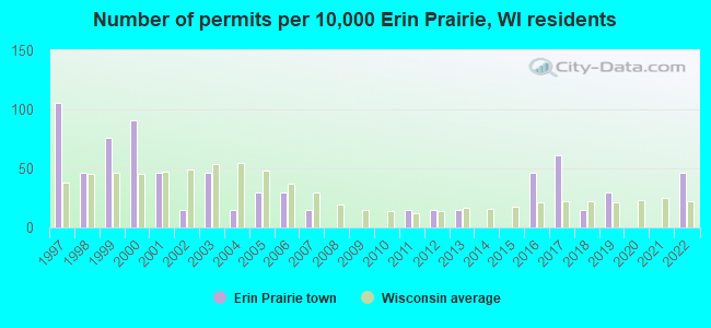
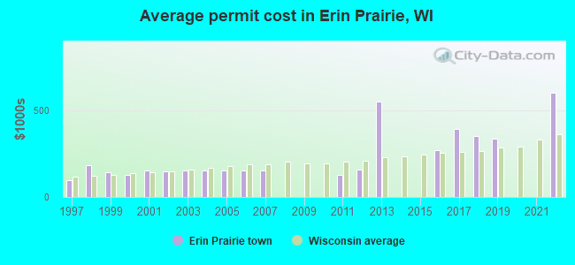
Single-family new house construction building permits:
- 2022: 3 buildings, average cost: $603,300
- 2019: 2 buildings, average cost: $337,500
- 2018: 1 building, cost: $352,000
- 2017: 4 buildings, average cost: $393,700
- 2016: 3 buildings, average cost: $272,300
- 2013: 1 building, cost: $550,000
- 2012: 1 building, cost: $160,000
- 2011: 1 building, cost: $127,000
- 2007: 1 building, cost: $153,700
- 2006: 2 buildings, average cost: $153,700
- 2005: 2 buildings, average cost: $153,700
- 2004: 1 building, cost: $153,700
- 2003: 3 buildings, average cost: $153,700
- 2002: 1 building, cost: $150,000
- 2001: 3 buildings, average cost: $153,300
- 2000: 6 buildings, average cost: $127,200
- 1999: 5 buildings, average cost: $145,000
- 1998: 3 buildings, average cost: $183,300
- 1997: 7 buildings, average cost: $99,300
| Here: | 3.5% |
| Wisconsin: | 2.7% |
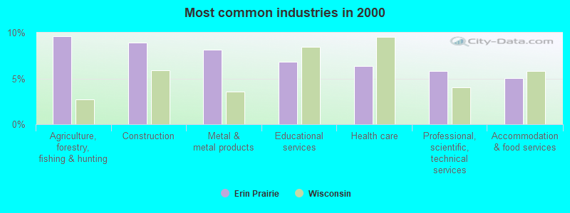
- Agriculture, forestry, fishing & hunting (9.6%)
- Construction (8.9%)
- Metal & metal products (8.1%)
- Educational services (6.9%)
- Health care (6.3%)
- Professional, scientific, technical services (5.8%)
- Accommodation & food services (5.1%)
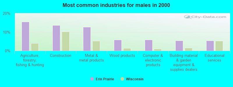
- Agriculture, forestry, fishing & hunting (15.5%)
- Construction (13.7%)
- Metal & metal products (12.8%)
- Wood products (5.9%)
- Computer & electronic products (5.9%)
- Building material & garden equipment & supplies dealers (5.5%)
- Educational services (5.5%)
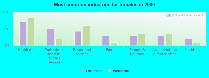
- Health care (14.3%)
- Professional, scientific, technical services (9.7%)
- Educational services (8.6%)
- Food (5.7%)
- Finance & insurance (5.7%)
- Accommodation & food services (5.7%)
- Machinery (4.0%)
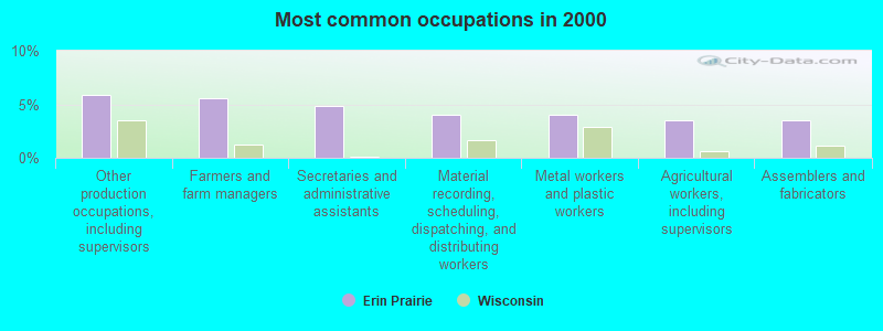
- Other production occupations, including supervisors (5.8%)
- Farmers and farm managers (5.6%)
- Secretaries and administrative assistants (4.8%)
- Material recording, scheduling, dispatching, and distributing workers (4.1%)
- Metal workers and plastic workers (4.1%)
- Agricultural workers, including supervisors (3.6%)
- Assemblers and fabricators (3.6%)
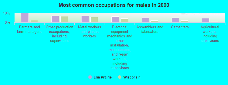
- Farmers and farm managers (10.0%)
- Other production occupations, including supervisors (7.3%)
- Metal workers and plastic workers (7.3%)
- Electrical equipment mechanics and other installation, maintenance, and repair workers, including supervisors (6.4%)
- Assemblers and fabricators (5.5%)
- Carpenters (5.0%)
- Agricultural workers, including supervisors (4.6%)

- Secretaries and administrative assistants (10.9%)
- Waiters and waitresses (5.7%)
- Advertising, marketing, promotions, public relations, and sales managers (5.1%)
- Retail sales workers, except cashiers (5.1%)
- Preschool, kindergarten, elementary, and middle school teachers (4.6%)
- Other sales and related occupations, including supervisors (4.6%)
- Other management occupations, except farmers and farm managers (4.0%)
Average climate in Erin Prairie, Wisconsin
Based on data reported by over 4,000 weather stations


Tornado activity:
Erin Prairie-area historical tornado activity is near Wisconsin state average. It is 16% greater than the overall U.S. average.
On 6/4/1958, a category F5 (max. wind speeds 261-318 mph) tornado 13.7 miles away from the Erin Prairie town center killed 21 people and injured 74 people and caused between $5,000,000 and $50,000,000 in damages.
On 5/6/1965, a category F4 (max. wind speeds 207-260 mph) tornado 32.4 miles away from the town center killed 6 people and injured 158 people and caused between $5,000,000 and $50,000,000 in damages.
Earthquake activity:
Erin Prairie-area historical earthquake activity is significantly above Wisconsin state average. It is 62% smaller than the overall U.S. average.On 7/9/1975 at 14:54:15, a magnitude 4.6 (4.6 MB, Class: Light, Intensity: IV - V) earthquake occurred 180.2 miles away from Erin Prairie center
On 6/5/1993 at 01:24:53, a magnitude 4.1 (4.1 LG, Depth: 6.2 mi) earthquake occurred 192.2 miles away from Erin Prairie center
On 3/4/1983 at 06:32:18, a magnitude 4.6 (4.4 MB, 4.6 LG, 4.4 ML) earthquake occurred 348.7 miles away from the city center
On 10/20/1995 at 15:57:18, a magnitude 3.7 (3.7 LG, Depth: 3.1 mi, Class: Light, Intensity: II - III) earthquake occurred 220.7 miles away from the city center
On 6/28/2004 at 06:10:52, a magnitude 4.2 (4.2 MW, Depth: 6.2 mi) earthquake occurred 307.3 miles away from the city center
On 2/9/1994 at 08:45:35, a magnitude 3.1 (3.1 LG, Depth: 3.1 mi) earthquake occurred 125.9 miles away from the city center
Magnitude types: regional Lg-wave magnitude (LG), body-wave magnitude (MB), local magnitude (ML), moment magnitude (MW)
Natural disasters:
The number of natural disasters in St. Croix County (1) is a lot smaller than the US average (15).Major Disasters (Presidential) Declared: 1
Causes of natural disasters: Other: 1 (Note: some incidents may be assigned to more than one category).
Hospitals and medical centers near Erin Prairie:
- DEERFIELD CARE CENTER, LLC (Nursing Home, about 7 miles away; NEW RICHMOND, WI)
- WESTFIELDS HOSPITAL Critical Access Hospitals (about 7 miles away; NEW RICHMOND, WI)
- AMERICAN HERITAGE CARE CTR (Nursing Home, about 8 miles away; HAMMOND, WI)
- BALDWIN CARE CENTER (Nursing Home, about 10 miles away; BALDWIN, WI)
- PARK VIEW HOME (Nursing Home, about 12 miles away; WOODVILLE, WI)
- GLENHAVEN (Nursing Home, about 14 miles away; GLENWOOD CITY, WI)
- BALDWIN AREA MED CTR Critical Access Hospitals (about 15 miles away; BALDWIN, WI)
Colleges/universities with over 2000 students nearest to Erin Prairie:
- University of Wisconsin-River Falls (about 19 miles; River Falls, WI; Full-time enrollment: 5,868)
- Century College (about 28 miles; White Bear Lake, MN; FT enrollment: 7,393)
- University of Wisconsin-Stout (about 28 miles; Menomonie, WI; FT enrollment: 8,120)
- Metropolitan State University (about 33 miles; Saint Paul, MN; FT enrollment: 6,159)
- Saint Paul College (about 35 miles; Saint Paul, MN; FT enrollment: 4,778)
- Inver Hills Community College (about 36 miles; Inver Grove Heights, MN; FT enrollment: 4,049)
- Bethel University (about 36 miles; Saint Paul, MN; FT enrollment: 4,061)
Points of interest:
Notable location: Erin Prairie Townhall (A). Display/hide its location on the map
Church in Erin Prairie: Saint Patricks Church (A). Display/hide its location on the map
Lakes and reservoirs: Casey Lake (A), 2 Reservoir (B). Display/hide their locations on the map
Streams, rivers, and creeks: Dry Run (A), South Fork Willow River (B). Display/hide their locations on the map
Park in Erin Prairie: Casey Lake State Wildlife Area (1). Display/hide its location on the map
| This town: | 2.7 people |
| Wisconsin: | 2.4 people |
| This town: | 77.5% |
| Whole state: | 64.4% |
| This town: | 7.4% |
| Whole state: | 7.3% |
Likely homosexual households (counted as self-reported same-sex unmarried-partner households)
- Lesbian couples: 0.8% of all households
- Gay men: 0.4% of all households
| This town: | 3.0% |
| Whole state: | 8.7% |
| This town: | 0.7% |
| Whole state: | 3.7% |
For population 15 years and over in Erin Prairie:
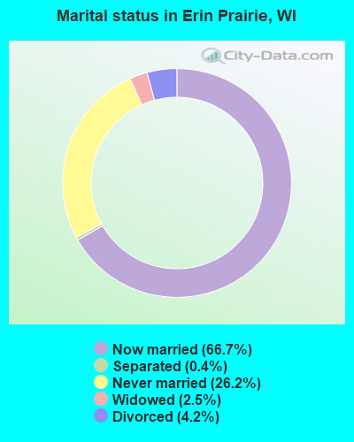
- Never married: 26.2%
- Now married: 66.7%
- Separated: 0.4%
- Widowed: 2.5%
- Divorced: 4.2%
For population 25 years and over in Erin Prairie:
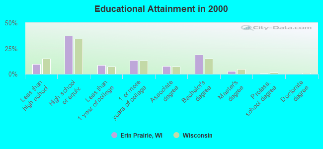
- High school or higher: 90.1%
- Bachelor's degree or higher: 22.4%
- Graduate or professional degree: 3.6%
- Unemployed: 3.9%
- Mean travel time to work (commute): 26.6 minutes
| Here: | 9.1 |
| Wisconsin average: | 11.0 |

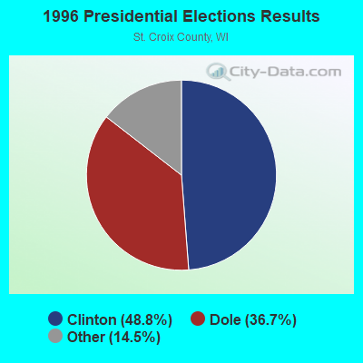
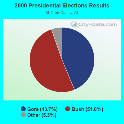


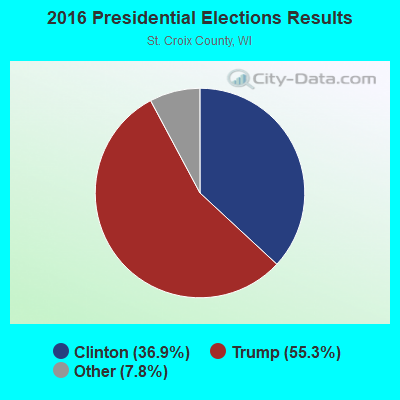
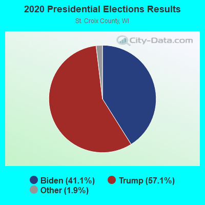
Graphs represent county-level data. Detailed 2008 Election Results
Religion statistics for Erin Prairie, WI (based on St. Croix County data)
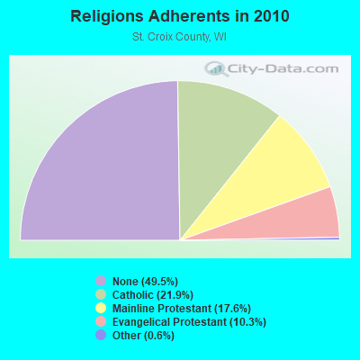
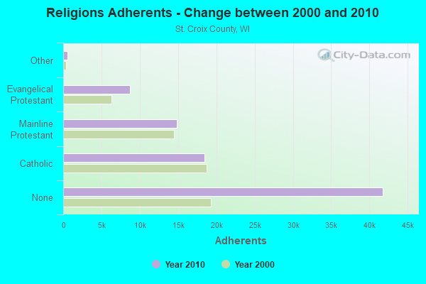
| Religion | Adherents | Congregations |
|---|---|---|
| Catholic | 18,471 | 9 |
| Mainline Protestant | 14,848 | 30 |
| Evangelical Protestant | 8,725 | 34 |
| Other | 537 | 5 |
| None | 41,764 | - |
Food Environment Statistics:
| This county: | 1.11 / 10,000 pop. |
| Wisconsin: | 1.86 / 10,000 pop. |
| St. Croix County: | 0.12 / 10,000 pop. |
| State: | 0.11 / 10,000 pop. |
| Here: | 4.82 / 10,000 pop. |
| State: | 4.12 / 10,000 pop. |
| St. Croix County: | 8.27 / 10,000 pop. |
| Wisconsin: | 8.64 / 10,000 pop. |
| This county: | 6.4% |
| Wisconsin: | 7.6% |
| St. Croix County: | 26.1% |
| Wisconsin: | 27.5% |
| St. Croix County: | 12.7% |
| Wisconsin: | 13.0% |
Strongest AM radio stations in Erin Prairie:
- WIXK (1590 AM; daytime; 5 kW; NEW RICHMOND, WI; Owner: WIXK-AM, LLC)
- WCTS (1030 AM; 50 kW; MAPLEWOOD, MN; Owner: CNTL. BAPT. THEO/AL SEMI MINNEAPOLIS)
- WDGY (630 AM; 8 kW; HUDSON, WI; Owner: 630 RADIO, INCORPORATED)
- KSTP (1500 AM; 50 kW; ST. PAUL, MN; Owner: KSTP-AM, LLC (DELAWARE))
- KTIS (900 AM; 25 kW; MINNEAPOLIS, MN; Owner: NORTHWESTERN COLLEGE)
- WCCO (830 AM; 50 kW; MINNEAPOLIS, MN; Owner: INFINITY MEDIA CORPORATION)
- WXCE (1260 AM; 5 kW; AMERY, WI; Owner: LAKE COUNTRY BROADCASTING CORPORATION)
- KFAN (1130 AM; 50 kW; MINNEAPOLIS, MN; Owner: AMFM RADIO LICENSES, L.L.C.)
- WMGT (1220 AM; 5 kW; STILLWATER, MN; Owner: ENDURANCE BROADCASTING, LLC)
- WMEQ (880 AM; 10 kW; MENOMONIE, WI; Owner: CAPSTAR TX LIMITED PARTNERSHIP)
- WMIN (740 AM; daytime; 1 kW; HUDSON, WI; Owner: WRPX, INC.)
- WEBC (560 AM; 50 kW; DULUTH, MN)
- KUOM (770 AM; daytime; 5 kW; MINNEAPOLIS, MN)
Strongest FM radio stations in Erin Prairie:
- WXPT (104.1 FM; ST. LOUIS PARK, MN; Owner: THE AUDIO HOUSE, INC.)
- WHWC (88.3 FM; MENOMONIE, WI; Owner: STATE OF WISCONSIN - EDUCATIONAL COMMUNICATIONS BOARD)
- KNOW-FM (91.1 FM; MINNEAPOLIS-ST. PAUL, MN; Owner: MINNESOTA PUBLIC RADIO)
- WLTE (102.9 FM; MINNEAPOLIS, MN; Owner: INFINITY MEDIA CORPORATION)
- KSTP-FM (94.5 FM; ST. PAUL, MN; Owner: KSTP-FM, LLC, A DELAWARE LLC)
- KEEY-FM (102.1 FM; ST. PAUL, MN; Owner: AMFM RADIO LICENSES, L.L.C.)
- KTIS-FM (98.5 FM; MINNEAPOLIS, MN; Owner: NORTHWESTERN COLLEGE)
- KDWB-FM (101.3 FM; RICHFIELD, MN; Owner: AMFM RADIO LICENSES, L.L.C.)
- KQRS-FM (92.5 FM; GOLDEN VALLEY, MN; Owner: KQRS, Inc.)
- KSJN (99.5 FM; MINNEAPOLIS, MN; Owner: MINNESOTA PUBLIC RADIO)
- KXXR (93.7 FM; MINNEAPOLIS, MN; Owner: KQRS, INC.)
- WVSS (90.7 FM; MENOMONIE, WI; Owner: BD. OF REGENTS, UNIVERSITY OF WISCONSIN SYSTEM)
- W211AY (90.1 FM; MENOMONIE, WI; Owner: CALVARY CHAPEL OF TWIN FALLS, INC.)
- WEVR-FM (106.3 FM; RIVER FALLS, WI; Owner: HANTEN BROADCASTING COMPANY, INC.)
- WMEQ-FM (92.1 FM; MENOMONIE, WI; Owner: CAPSTAR TX LIMITED PARTNERSHIP)
- WFMP (107.1 FM; COON RAPIDS, MN; Owner: WFMP-FM, LLC)
TV broadcast stations around Erin Prairie:
- KMSP-TV (Channel 9; MINNEAPOLIS, MN; Owner: FOX TELEVISION STATIONS, INC.)
- KARE (Channel 11; MINNEAPOLIS, MN; Owner: MULTIMEDIA HOLDINGS CORPORATION)
- KTCA-TV (Channel 2; ST. PAUL, MN; Owner: TWIN CITIES PUBLIC TELEVISION, INC.)
- KSTP-TV (Channel 5; ST. PAUL, MN; Owner: HUBBARD BROADCASTING, INC.)
- WHWC-TV (Channel 28; MENOMONIE, WI; Owner: STATE OF WISCONSIN - EDUCATIONAL COMMUNICATIONS BOARD)
- WCCO-TV (Channel 4; MINNEAPOLIS, MN; Owner: CBS BROADCASTING INC.)
- KTCI-TV (Channel 17; ST. PAUL, MN; Owner: TWIN CITIES PUBLIC TELEVISION, INC.)
- KSTC-TV (Channel 45; MINNEAPOLIS, MN; Owner: HUBBARD BROADCASTING, INC.)
- KMWB (Channel 23; MINNEAPOLIS, MN; Owner: KLGT LICENSEE, LLC)
- WFTC (Channel 29; MINNEAPOLIS, MN; Owner: FOX TELEVISION STATIONS, INC.)
- W55AP (Channel 55; RIVER FALLS, WI; Owner: STATE OF WISCONSIN - EDUCATIONAL COMMUNICATIONS BOARD)
- National Bridge Inventory (NBI) Statistics
- 18Number of bridges
- 85ft / 25.6mTotal length
- 14,344Total average daily traffic
- 563Total average daily truck traffic
- 18,164Total future (year 2039) average daily traffic
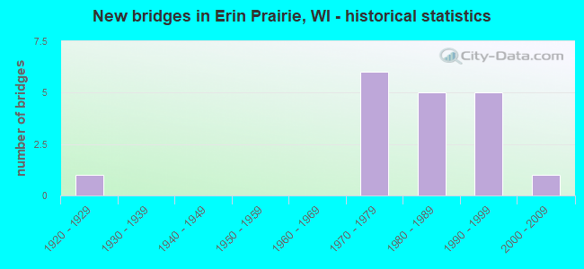
- New bridges - historical statistics
- 11920-1929
- 61970-1979
- 51980-1989
- 51990-1999
- 12000-2009
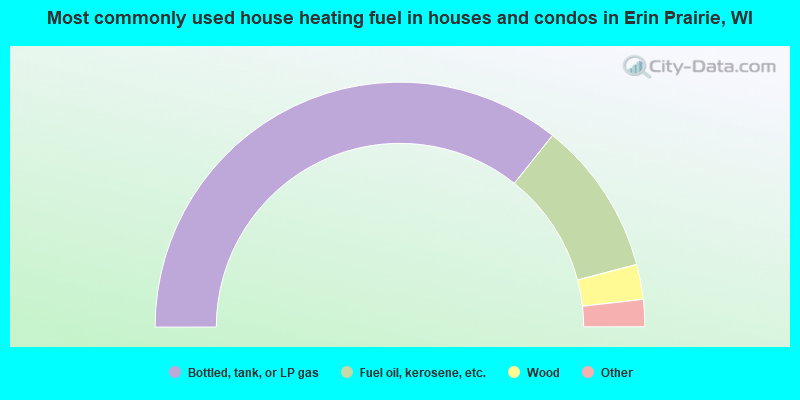
- 71.4%Bottled, tank, or LP gas
- 20.4%Fuel oil, kerosene, etc.
- 4.6%Wood
- 2.0%Electricity
- 1.5%Utility gas
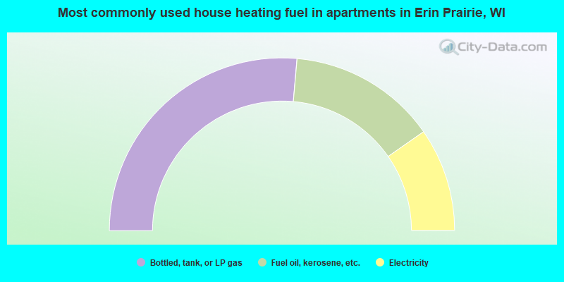
- 52.8%Bottled, tank, or LP gas
- 27.8%Fuel oil, kerosene, etc.
- 19.4%Electricity
Erin Prairie compared to Wisconsin state average:
- Median household income above state average.
- Median house value above state average.
- Unemployed percentage significantly below state average.
- Black race population percentage significantly below state average.
- Hispanic race population percentage significantly below state average.
- Foreign-born population percentage significantly below state average.
- Renting percentage below state average.
- Length of stay since moving in significantly above state average.
- Number of rooms per house significantly below state average.
- House age significantly below state average.